DE102006044293A1 - Computerized method for mobile object localization, involves measuring characteristics of number of base stations using reference map, where base station characterizes field transmitted by base station at object - Google Patents
Computerized method for mobile object localization, involves measuring characteristics of number of base stations using reference map, where base station characterizes field transmitted by base station at object Download PDFInfo
- Publication number
- DE102006044293A1 DE102006044293A1 DE102006044293A DE102006044293A DE102006044293A1 DE 102006044293 A1 DE102006044293 A1 DE 102006044293A1 DE 102006044293 A DE102006044293 A DE 102006044293A DE 102006044293 A DE102006044293 A DE 102006044293A DE 102006044293 A1 DE102006044293 A1 DE 102006044293A1
- Authority
- DE
- Germany
- Prior art keywords
- base station
- feature
- location
- base stations
- path
- Prior art date
- Legal status (The legal status is an assumption and is not a legal conclusion. Google has not performed a legal analysis and makes no representation as to the accuracy of the status listed.)
- Ceased
Links
Classifications
-
- H—ELECTRICITY
- H04—ELECTRIC COMMUNICATION TECHNIQUE
- H04B—TRANSMISSION
- H04B17/00—Monitoring; Testing
- H04B17/30—Monitoring; Testing of propagation channels
- H04B17/309—Measuring or estimating channel quality parameters
- H04B17/318—Received signal strength
-
- G—PHYSICS
- G01—MEASURING; TESTING
- G01S—RADIO DIRECTION-FINDING; RADIO NAVIGATION; DETERMINING DISTANCE OR VELOCITY BY USE OF RADIO WAVES; LOCATING OR PRESENCE-DETECTING BY USE OF THE REFLECTION OR RERADIATION OF RADIO WAVES; ANALOGOUS ARRANGEMENTS USING OTHER WAVES
- G01S5/00—Position-fixing by co-ordinating two or more direction or position line determinations; Position-fixing by co-ordinating two or more distance determinations
- G01S5/02—Position-fixing by co-ordinating two or more direction or position line determinations; Position-fixing by co-ordinating two or more distance determinations using radio waves
- G01S5/0252—Radio frequency fingerprinting
- G01S5/02521—Radio frequency fingerprinting using a radio-map
- G01S5/02524—Creating or updating the radio-map
-
- H—ELECTRICITY
- H04—ELECTRIC COMMUNICATION TECHNIQUE
- H04W—WIRELESS COMMUNICATION NETWORKS
- H04W64/00—Locating users or terminals or network equipment for network management purposes, e.g. mobility management
-
- H—ELECTRICITY
- H04—ELECTRIC COMMUNICATION TECHNIQUE
- H04B—TRANSMISSION
- H04B17/00—Monitoring; Testing
- H04B17/30—Monitoring; Testing of propagation channels
- H04B17/391—Modelling the propagation channel
Landscapes
- Engineering & Computer Science (AREA)
- Physics & Mathematics (AREA)
- Computer Networks & Wireless Communication (AREA)
- Signal Processing (AREA)
- Quality & Reliability (AREA)
- Electromagnetism (AREA)
- General Physics & Mathematics (AREA)
- Radar, Positioning & Navigation (AREA)
- Remote Sensing (AREA)
- Mobile Radio Communication Systems (AREA)
- Position Fixing By Use Of Radio Waves (AREA)
Abstract
Description
Die Erfindung betrifft ein Verfahren und eine Vorrichtung zur rechnergestützten Lokalisation eines mobilen Objekts.The The invention relates to a method and a device for computer-assisted localization a mobile object.
Aus dem Stand der Technik sind verschiedene merkmalsbasierte Ortungsverfahren von mobilen Nutzern bzw. Endgeräten in drahtlosen Kommunikationsnetzen bekannt. Dabei werden als Merkmale z.B. die Feldstärken von Feldern durch das mobile Objekt gemessen, wobei die Felder in dem Kommunikationsnetz von einer Mehrzahl von Basisstationen erzeugt und ausgesendet werden. Als Kommunikationsnetze werden beispielsweise DECT-Netze (DECT = Digital Enhanced Cordless Telecommunications), WLAN-Netze (WLAN = Wireless Local Area Network) sowie die Mobilfunknetze GSM (GSM = Global System for Mobile Communication) und UMTS (UMTS = Universal Mobile Telecommunication System) eingesetzt.Out The prior art has various feature-based location methods from mobile users or terminals known in wireless communication networks. Here are as characteristics e.g. the field strengths of fields measured by the mobile object, with the fields in the communication network generated by a plurality of base stations and sent out. As communication networks, for example DECT networks (DECT = Digital Enhanced Cordless Telecommunications), WLAN networks (WLAN = Wireless Local Area Network) and GSM (GSM = Global System for Mobile Communication) and UMTS (UMTS = Universal Mobile Telecommunication System) is used.
Bei der merkmalsbasierten Ortung werden so genannte Referenzkarten verwendet, in denen für eine Vielzahl von Stützstellen eine Beziehung zwischen der räumlichen Position der Stützstelle und merkmalsabhängigen Größen der einzelnen Basisstationen hinterlegt ist. Merkmalsabhängige Größen sind beispielsweise in einem feldstärkebasierten Verfahren die Feldstärke des von einer Basisstation ausgesendeten Feldes an der räumlichen Position der Stützstelle oder die an der Basisstation gemessene Feldstärke eines Feldes, das von einem Objekt ausgesendet wird, welches sich an der räumlichen Position der Stützstelle befindet. Durch die Messung der Feldstärke an einer beliebigen Position und durch Vergleich des gemessenen Wertes mit den feldstärkeabhängigen Größen an den Stützstellen der Referenzkarte kann die Position des Objekts ermittelt werden. Bei dem aus dem Stand der Technik bekannten feldstärkebasierten Verfahren ist eine Kalibrierung bzw. Einmessung von Referenzmustern erforderlich, um eine ausreichende Genau igkeit in strukturierten Umgebungen zu erreichen. Diese Kalibrierung ist personal- und kostenintensiv und umso aufwändiger, je höher die gewünschte Genauigkeit ist.at feature based locating uses so-called reference maps in which for a variety of support points a relationship between the spatial Position of the support point and feature-dependent Sizes of individual base stations is deposited. Are feature-dependent variables for example, in a field strength based Method the field strength of the field emitted by a base station at the spatial Position of the support point or the field strength of a field measured at the base station, that of a Object is emitted, which is based on the spatial position of the support point located. By measuring the field strength at any position and by comparing the measured value with the field strength dependent quantities to the reference points The reference card can be used to determine the position of the object. In the field strength based known from the prior art Method is a calibration or measurement of reference patterns necessary to have sufficient accuracy in structured To reach environments. This calibration is labor intensive and costly and all the more elaborate the higher the desired Accuracy is.
Neben einer Kalibrierung mit Referenzmustern ist es aus dem Stand der Technik ferner bekannt, die Position der empfangsstärksten Basisstation in dem mobilen Objekt über einfache Trilaterationsmodelle zu ermitteln, beispielsweise unter der Annahme einer radialen Feldausbreitung. Bei solchen Verfahren werden wenige Parameter benötigt, welche über wenige Referenzmessungen angepasst werden können. Diese Verfahren haben jedoch den Nachteil, dass deren erreichte Genauigkeit deutlich geringer ist als bei Verfahren, bei denen eine Referenzkarte mit einer Vielzahl von Messungen erstellt wird.Next a calibration with reference patterns, it is from the state of Technik also known, the position of the strongest receiving base station in the mobile object via to determine simple trilateration models, for example under the assumption of a radial field propagation. In such procedures few parameters are needed which over few reference measurements can be adjusted. These procedures have but the disadvantage that their achieved accuracy significantly lower is as in procedures where a reference card with a variety of measurements is created.
Aufgabe der Erfindung ist es, ein einfaches Lokalisationsverfahren zu schaffen, welches eine hohe Genauigkeit aufweist und mit geringem Aufwand ohne die Durchführung einer Vielzahl von Referenzmessungen zu installieren ist.task the invention is to provide a simple localization method, which has a high accuracy and with little effort without the implementation a variety of reference measurements is to install.
Diese Aufgabe wird durch die unabhängigen Patentansprüche gelöst. Weiterbildungen der Erfindung sind in den abhängigen Ansprüchen definiert.These Task is by the independent claims solved. Further developments of the invention are defined in the dependent claims.
In dem erfindungsgemäßen Verfahren werden mit Hilfe eines merkmalsbasierten Ortungsverfahrens die Merkmale von mehreren Basisstationen gemessen und hieraus unter Verwendung einer Referenzkarte die Position des Objekts geortet. Das Merkmal einer Basisstation ist hierbei ein Merkmal, welches mit einem Feld assoziiert ist, wobei das Feld ein von der Basisstation ausgesendetes Feld an der Position des Objekts oder ein von dem Objekt ausgesendetes Feld an der Basisstation ist. Durch das Feld wird somit eine Beziehung zwischen einer einzelnen Basisstation und der Position des Objekts im Raum geschaffen. Das Verfahren wird hierbei in einem ersten Schritt mit einer Referenzkarte initialisiert, welche eine Vielzahl von Stützstellen umfasst, wobei eine Stützstelle jeweils durch eine Position und einen der Position zugeordneten merkmalsabhängi gen Wert repräsentiert wird. Hier um im Folgenden wird unter merkmalsabhängigem Wert ein Wert verstanden, der von den zuvor beschriebenen Merkmalen der Basisstationen abhängt. Insbesondere kann der merkmalsabhängige Wert ein Merkmalsvektor sein, der die Merkmale aller Basisstationen umfasst. In einem feldstärkebasierten Verfahren ist der merkmalsabhängige Wert beispielsweise ein feldstärkeabhängiger Wert. Insbesondere kann der Wert in einem solchen Verfahren ein Feldstärkevektor sein, der die Feldstärken von jeder Basisstation als Einträge umfasst. Die Feldstärken der Basisstationen können hierbei die Feldstärken von von den Basisstationen ausgesendeten Feldern an der Objektposition sein. Sie können jedoch auch die Feldstärken von von dem Objekt ausgesendeten Feldern am Ort der einzelnen Basisstationen sein. Das erfindungsgemäße Verfahren ist nicht auf die Verwendung von feldstärkebasierten Ortungsverfahren beschränkt, es können insbesondere als Ortungsverfahren auch laufzeitbasierte bzw. winkelbasierte Ortungsverfahren eingesetzt werden. Bei laufzeitbasierten Ortungsverfahren wird die Position eines Objekts über die Laufzeit eines Feldes ermittelt. Bei winkelbasierten Ortungsverfahren wird die Position eines Objekts über die räumlichen Winkel bestimmt, in welchen ein Feld auf ein Objekt bzw. eine Basisstation trifft.In the method according to the invention, the features of several base stations are measured with the aid of a feature-based locating method, and the position of the object is located therefrom using a reference card. The feature of a base station here is a feature associated with a field, the field being a field transmitted by the base station at the position of the object or a field transmitted by the object at the base station. The field thus establishes a relationship between a single base station and the position of the object in space. In this case, the method is initialized in a first step with a reference card which comprises a multiplicity of interpolation points, wherein a interpolation point is represented in each case by a position and a feature-dependent value associated with the position. Hereinafter, the feature-dependent value is understood to mean a value which depends on the features of the base stations described above. In particular, the feature-dependent value may be a feature vector comprising the features of all base stations. For example, in a field strength based method, the feature dependent value is a field strength dependent value. In particular, the value in such a method may be a field strength vector comprising the field strengths of each base station as entries. In this case, the field strengths of the base stations can be the field strengths of fields transmitted by the base stations at the object position. However, they can also be the field strengths of fields emitted by the object at the location of the individual base stations. The method according to the invention is not limited to the use of field-strength-based location methods; in particular, time-based or angle-based location methods can be used as locating methods. In runtime-based location methods, the position of an object is determined over the runtime of a field. In angle-based locating methods, the position of an object is determined by the spatial angles is true in which a field meets an object or a base station.
Nach der Initialisierung wird im Betrieb eine Mehrzahl von Ortungen durchgeführt, mit denen jeweils ein gemessener merkmalsabhängiger Wert und hieraus eine geortete Position des Objekts über das merkmalsbasierte Ortungsverfahren unter Verwendung der vorgegebenen Referenzkarte ermittelt werden. Dabei werden für zumindest einen Teil der Ortungen jeweils eine oder mehrere Aktualisierungen der vorgegebenen Referenzkarte durchgeführt, bei welchen die merkmalsabhängigen Werte an den Stützstellen der Referenzkarte in einer vorbestimmten Umgebung um eine Objektposition mit einem Korrekturterm korrigiert werden, wobei der Korrekturterm von der Differenz zwischen dem gemessenen merkmalsabhängigen Wert der jeweiligen Ortung und dem merkmalsabhängigen Wert an einer Stützstelle in der vorbestimmten Umgebung abhängt. Die vorbestimmte Umge bung kann hierbei je nach Anforderungen beliebig gewählt werden und insbesondere auch das gesamte Gebiet der Referenzkarte umfassen.To During initialization, a plurality of localizations is performed during operation, with each one a measured feature-dependent value and from this one located position of the object over the feature-based location method using the given Reference card can be determined. Here are at least a part of the Locations one or more updates of the given reference card carried out, where the feature-dependent Values at the interpolation points the reference card in a predetermined environment around an object position be corrected with a correction term, the correction term from the difference between the measured feature-dependent value the respective location and the feature-dependent value at a support point depends in the predetermined environment. The predetermined environment can be chosen arbitrarily depending on the requirements and in particular also cover the entire territory of the reference card.
Die Objektposition, um welche die vorbestimmte Umgebung angeordnet ist, kann hierbei beispielsweise eine vorbekannte Position sein, das heißt es ist in dem Verfahren bekannt, an welcher Stelle sich das Objekt befindet, wenn eine entsprechende Ortung durchgeführt wird. In diesem Fall dient das erfindungsgemäße Verfahren zur hochgenauen Kalibrierung einer Referenzkarte, ohne dass das Verfahren zur Ortung von unbekannten Positionen genutzt wird. Die Objektposition kann jedoch auch eine unbekannte Position sein, welche die durch die jeweilige Ortung ermittelte geortete Position ist. In diesem Fall wird bei der Durchführung des Verfahrens eine Ortung und simultan eine Kalibrierung und damit Verbesserung der Ortungsgenauigkeit durchgeführt. Die Aktualisierung der Referenzkarte gemäß dem erfindungsgemäßen Verfahrens kann hierbei immer zum Zeitpunkt der jeweiligen Ortung durchgeführt werden, es besteht jedoch auch die Möglichkeit, dass der Schritt erst nach Ablauf einer vorbestimmten Anzahl von Ortungen durchgeführt wird, wobei dann vorzugsweise alle Objektpositionen bis zur vorhergehenden Ortung mit einem Korrekturterm korrigiert werden.The Object position around which the predetermined environment is arranged Here, for example, may be a known position, the is called it is known in the process where the object is located, if a corresponding location is carried out. In this case serves the inventive method for the high-precision calibration of a reference card, without the Method of locating unknown positions is used. The However, object position can also be an unknown position, which is the determined location determined by the respective location. In this case, when performing the method becomes a location and simultaneously a calibration and thus improvement of the positioning accuracy carried out. The update of the reference card according to the inventive method can always be done at the time of the respective location, but there is also the possibility that the step is only after a predetermined number of Locations performed is, then preferably all object positions to the previous Positioning can be corrected with a correction term.
Die bei der Initialisierung des Verfahrens vorgegebene Referenzkarte kann beispielsweise mit einem Wellenausbreitungsmodell berechnet werden. Als Wellenausbreitungsmodell kann beispielsweise ein radiales Ausbreitungsmodell, ein MWM-Ausbreitungsmodell (MWM = Multi Wall Model) oder ein DPM-Ausbreitungsmodell (DPM = Dominant Path Model) eingesetzt werden. Diese Ausbreitungsmodelle werden noch näher in der detaillierten Beschreibung erläutert. Durch die Verwendung solcher Wellenausbreitungsmodelle kann einfach und schnell bei der Initialisierung des Verfahrens eine Referenzkarte vorgegeben werden, ohne dass aufwändige Referenzmessungen an einer Vielzahl von Positionen durchgeführt werden müssen. Es reicht insbesondere aus, dass die Parameter des Ausbreitungsmodells durch eine einfache Selbstvermessung der Basisstationen ermittelt werden.The at the initialization of the method given reference card can for example be calculated with a wave propagation model become. As a wave propagation model, for example, a radial propagation model, a MWM propagation model (MWM = Multi Wall Model) or a DPM propagation model (DPM = Dominant Path Model). These propagation models will be even closer explained in the detailed description. By use Such wave propagation models can be easily and quickly at the Initialization of the procedure a reference card can be preset, without that elaborate Reference measurements are performed at a variety of positions have to. It is sufficient in particular that the parameters of the propagation model by a simple self-measurement of the base stations are determined.
In einer bevorzugten Ausführungsform wird die Mehrzahl von Ortungen jeweils mit Hilfe eines Fingerprinting-Verfahrens durchgeführt. Das Fingerprinting-Verfahren ist hinlänglich aus dem Stand der Technik bekannt und wird noch näher in der detaillierten Beschreibung erläutert. Gegebenenfalls können jedoch auch andere Verfahren zur Ortung eingesetzt werden, beispielsweise Verfahren, welche eine wahrscheinlichkeitstheoretische Kostenfunktion auf der Basis der für den Korrekturterm ermittelten Differenzen einsetzen, um hiermit die geortete Position zu ermitteln.In a preferred embodiment The majority of locators are each using a fingerprinting method carried out. The fingerprinting method is well-known in the art known and will be even closer explained in the detailed description. However, if necessary Other methods of locating be used, for example Method, which is a probabilistic cost function on the basis of for use the correction term differences to hereby use the to determine the location determined.
In einer besonders bevorzugten Ausführungsform der Erfindung nimmt die Größe des Korrekturterms mit zunehmendem Abstand von der Objektposition betragsmäßig ab, wodurch der Tatsache Rechnung getragen wird, dass der Fehler gemäß dem Korrekturterm nur lokal Einfluss auf den merkmalsabhängigen Wert hat.In a particularly preferred embodiment The invention includes the size of the correction term increasing the distance from the object position in terms of amount, whereby the fact is taken into account that the error according to the correction term only has local influence on the feature-dependent value.
In einer besonders bevorzugten Ausführungsform der Erfindung hängt der Korrekturterm von einer Gaußfunktion mit Zentrum in der Objektposition ab. Ferner hängt auch die vorbestimmte Umgebung um die Objektposition von einem Parameter der Gaußfunktion ab, nämlich von der Standardabweichung der Gaußfunktion. Die vorbestimmte Umgebung ist hierbei vorzugsweise durch einen Umkreis um das Zentrum der Gaußfunktion mit einem Radius gegeben, welcher größer oder gleich der Standardabweichung und insbesondere ein Vielfaches, vorzugsweise das Dreifache, der Standardabweichung ist. Die Werte der Gaußfunktion außerhalb dieses Umkreises sind derart klein, dass sie vernachlässigt werden können. Dadurch, dass nur noch bestimmte Stützstellen in der Umgebung um die Objektposition berücksichtigt werden, benötigt das Verfahren weniger Rechenzeit.In a particularly preferred embodiment the invention depends the correction term of a Gaussian function with center in the object position. Furthermore, the predetermined environment also depends around the object position of a parameter of the Gaussian function from, namely from the standard deviation of the Gaussian function. The predetermined one Environment here is preferably by a radius around the center the Gaussian function given a radius which is greater than or equal to the standard deviation and in particular a multiple, preferably three times, the Standard deviation is. The values of the Gaussian function outside of this perimeter are so small that they are neglected can. Due to the fact that only certain support points in the environment around considers the object position be needed the procedure less computing time.
Vorzugsweise ist die Standardabweichung der Gaußfunktion derart gewählt, dass sie von dem Abstand der Stützstellen der Referenzkarte abhängt und insbesondere zwischen dem Stütz stellenabstand und einem Fünffachen des Stützstellenabstands liegt. Um die Rechenzeit des Verfahrens zu reduzieren, wird in einer weiteren bevorzugten Variante der Erfindung die Gaußfunktion durch eine Funktion approximiert, welche mit zunehmenden Abstand vom Zentrum auf Null abfällt und insbesondere bei einem Wert größer oder gleich der Standardabweichung, vorzugsweise bei einem Dreifachen der Standardabweichung, Null ist. Eine derartige Funktion ist beispielsweise in der detaillierten Beschreibung in Gleichung (10) genannt.Preferably, the standard deviation of the Gaussian function is chosen such that it depends on the distance of the support points of the reference card and in particular between the support point distance and a fivefold of the interpolation point distance. In order to reduce the computing time of the method, in a further preferred variant of the invention, the Gaussian function is approximated by a function which decreases to zero with increasing distance from the center, and is zero, in particular at a value greater than or equal to the standard deviation, preferably at a triple of the standard deviation. Such a function is mentioned, for example, in the detailed description in equation (10).
In einer besonders bevorzugten Ausführungsform der Erfindung ist der gemessene merkmalsabhängige Wert ein am Objekt oder an den Basisstationen gemessener Merkmalsvektor, insbesondere ein Feldstärkevektor, zum Zeitpunkt der Ortung und die vorgegebene Referenzkarte ist eine Orts-Merkmalskarte, bei welcher die merkmalsabhängigen Werte Merkmalsvektoren für die Positionen der Stützstellen sind, wobei ein Merkmalsvektor als Einträge die Merkmale der Basisstationen für die entsprechende Position umfasst. Ggf. kann der merkmalsabhängige Wert auch eine Distanz sein, so dass die Referenzkarte eine Orts-Distanzkarte darstellt. Hierbei wird beispielsweise ein Wellenausbreitungsmodell genutzt, um von Feldstärkewerten auf dominante Distanzen zu schließen, welche in der Orts-Distanzkarte hinterlegt sind. In diesem Fall kann die Ortung über eine Trilaterationsrechnung bzw. eine Multilaterationsrechnung bei mehr als drei Basisstationen durchgeführt werden.In a particularly preferred embodiment According to the invention, the measured feature - dependent value is an object or at the base stations measured feature vector, in particular a Field vector, at the time of locating and the given reference card is one Location feature map, where the feature-dependent values are feature vectors for the Positions of the supporting points are, with a feature vector as entries the characteristics of the base stations for the corresponding position includes. Possibly. can be the feature-dependent value also be a distance so that the reference map represents a location distance map. For example, a wave propagation model is used here, around field strength values to close on dominant distances, which deposited in the local distance map are. In this case, the location can be via a trilateration calculation or a Multilaterationsrechnung be performed at more than three base stations.
In
einer besonders bevorzugten Ausführungsform
der Erfindung ist der Korrekturterm SUPD für eine Stützstelle
k innerhalb der vorbestimmten Umgebung durch folgende Funktion gegeben
bzw. hängt
von folgender Funktion ab: ![]()
wobei kΔp
ein Differenzmerkmalsvektor mit jeweils einem Eintrag für das Merkmal
einer Basisstation von N Basisstationen ist,
wobei der Differenzmerkmalsvektor kΔp
entweder definiert ist als:
oder definiert ist als: ![]()
where k Δp is a difference feature vector with one entry each for the feature of a base station of N base stations,
wherein the difference feature vector k Δp is either defined as:
or defined as:
Gemäß den genannten
Alternativen zur Berechnung von kΔp wird als
Wert für kΔp
entweder ein Vektor verwendet, der unabhängig von der Stützstelle
ist, die korrigiert wird, oder es wird ein Wert verwendet, in dem der
Wert des Merkmals an der betrachteten Stützstelle gemäß der Orts-Merkmalskarte
einfließt.
Die soeben definierte Variante des Verfahrens wird beispielsweise
zur Durchführung
eines so genannten unüberwachten Lernens
eingesetzt, bei dem zum Zeitpunkt der jeweiligen Ortung nicht bekannt
ist, an welcher Stelle sich das Objekt befindet. Dies bedeutet,
dass als Objektposition die durch die jeweilige Ortung ermittelte
geortete Position des Objekts verwendet wird. Es ist jedoch auch
möglich,
dass der Weg des mobilen Objekts vorgegeben ist und die Objektposition
zum Zeitpunkt der jeweiligen Ortung vorbekannt ist. Vorzugsweise
bewegt sich das Objekt dabei auf einem oder mehreren vorbestimmten
Wegabschnitten zwischen jeweils zwei Basisstationen, wobei auf dem
jeweiligen Wegabschnitt Q Objektpositionen vorbekannt sind und an
diesen Objektpositionen jeweils eine Ortung durchgeführt wird.
Vorzugsweise ist der Korrekturterm SUPD (r,
q) dabei an der Objektposition q (q = 1, ..., Q) aus den Q Objektpositionen
auf einem Wegabschnitt wie folgt definiert: 
wobei ζ ein positiver
Term ist, der sicherstellt, dass der Nenner nicht Null wird, wobei ζ vorzugsweise
kleiner als 1 ist und insbesondere 0,3 beträgt,
wobei qΔp ein Differenzmerkmalsvektor
mit jeweils einem Eintrag für
das Merkmal einer Basisstation von N Basisstationen ist,
wobei
der Differenzfeldstärkevektor qΔp
definiert ist als:
where ζ is a positive term which ensures that the denominator does not become zero, where ζ is preferably less than 1 and in particular 0.3,
where q Δp is a difference feature vector with one entry each for the feature of a base station of N base stations,
wherein the difference field strength vector q Δp is defined as:
Gemäß dieser Variante wird die Aktualisierung der Orts-Merkmalskarte immer nach Durchlaufen eines vorbestimmten Wegabschnitts durchgeführt, wobei bei der Aktualisierung die Summe aller Gaußfunktionen an den Positionen des Wegabschnitts berücksichtigt wird. Bei dieser Variante des Verfahrens handelt es sich um ein überwachtes Lernverfahren, da die Objektpositionen beim Lernverfahren vorbekannt sind.According to this Variant is always updating the location feature map after going through a predetermined path section performed, wherein in the update the sum of all Gaussian functions is taken into account at the positions of the route section. At this Variant of the procedure is a supervised learning procedure, since the object positions are already known in the learning process.
In einer bevorzugten Variante des soeben genannten Verfahrens ist der Abstand zwischen aufeinander folgenden Objektpositionen konstant und die Standardabweichung hängt von diesem konstanten Abstand ab und ist insbesondere direkt proportional zu dem konstanten Abstand.In a preferred variant of the just mentioned method is the Distance between successive object positions constant and the standard deviation depends from this constant distance and in particular is directly proportional to the constant distance.
In einer besonders bevorzugten Variante des überwachten Lernverfahrens läuft das mobile Objekt eine Sequenz von vorbestimmten Wegabschnitten ab, wobei die Reihenfolge der abgelaufenen Wegabschnitte mit Hilfe einer Kostenfunktion geeignet ermittelt wird. Die Kostenfunktion gibt hierbei vorzugsweise für einen jeweiligen Wegabschnitt an, wie groß der maximale Abstand einer Objektposition auf dem Wegabschnitt zur nächstgelegenen Basisstation oder zu einer bereits durchlaufenen nächstgelegenen Objektposition ist. Mit einer solchen Kostenfunktion wird erreicht, dass möglichst schnell ein großes Areal von Objektpositionen durch das Verfahren abgedeckt wird.In a particularly preferred variant of the supervised learning process that runs mobile object a sequence of predetermined path sections, the order of the expired route sections with the help of a Cost function is determined suitable. The cost function gives in this case preferably for a respective path section, how large the maximum distance of a Object position on the route section to the nearest base station or to an already traversed nearest object position is. With such a cost function is achieved that possible fast a big one Area of object positions is covered by the procedure.
In dem erfindungsgemäßen Verfahren kann das merkmalsbasierten Ortungsverfahren ein feldstärkebasiertes und/oder laufzeitbasiertes und/oder winkelbasiertes Ortungsverfahren umfassen. Vorzugsweise berücksichtigt das laufzeitbasierte Ortungsverfahren dabei nur solche Felder, welche eine Mindestsignalstärke am Objekt aufweisen.In the method according to the invention For example, the feature-based location method may be field strength-based and / or term-based and / or angle-based location method include. Preferably considered the term-based location method only those fields, which a minimum signal strength at Have object.
Das merkmalsbasierte Ortungsverfahren kann beliebige Felder verwenden, insbesondere Felder eines DECT- und/oder WLAN- und/oder Mobilfunk-Netzes.The feature-based locator can use any fields in particular fields of a DECT and / or WLAN and / or mobile network.
Neben dem soeben beschriebenen erfindungsgemäßen Verfahren betrifft die Erfindung ferner eine Vorrichtung zur rechnergestützten Ortung eines mobilen Objekts mit Hilfe eines merkmalsbasierten Ortungsverfahrens, mit dem die Merkmale von mehreren Basisstationen gemessen werden und hieraus unter Verwendung einer Referenzkarte die Position des Objekts geortet wird, wobei die Vorrichtung umfasst: wenigstens eine Antenne zum Empfang der Felder der Basisstationen und/oder zum Aussenden von Feldern zum Empfang durch die Basisstationen sowie eine Auswerteeinheit zum Auswerten der gemessenen Merkmale der Basisstationen. Die Auswerteeinheit ist dabei derart ausgestaltet, dass mit ihr das oben beschriebene erfindungsgemäße Verfahren durchführbar ist.Next The method according to the invention just described relates to The invention also relates to a device for computer-aided positioning a mobile object using a feature-based location method, with which the characteristics of several base stations are measured and from this, using a reference map, the position of the Object is located, the device comprising at least one Antenna for receiving the fields of the base stations and / or for broadcasting from fields to the reception by the base stations as well as an evaluation unit for evaluating the measured characteristics of the base stations. The evaluation unit is designed in such a way that with her the above described inventive method feasible is.
Ausführungsbeispiele der Erfindung werden nachfolgend anhand der beigefügten Figuren detailliert beschrieben.embodiments The invention will be described below with reference to the attached figures described in detail.
Es zeigen:It demonstrate:
In den nachfolgend beschriebenen Ausführungsformen des erfindungsgemäßen Verfahrens wird ein mobiles Objekt betrachtet, welches über wenigstens eine Antenne verfügt, mit der die Feldstärken von mehreren Basisstationen in der Umgebung des Objekts empfangen und gemessen werden können. Jede Basisstation sendet hierbei drahtlos Signale mit einer bestimmten Leistung (d.h. mit einem bestimmten Feldstärkewert) aus. Diese drahtlos übermittelten Signale verteilen sich im Raum, wobei sie reflektiert, gebeugt und absorbiert werden, und zwar durch Personen und andere Objekte im Raum, wie z.B. Wände, Maschinen oder Büromöbel in der Umgebung.In the embodiments of the method according to the invention described below a mobile object is considered which has at least one antenna features, with the field strengths received from multiple base stations in the vicinity of the object and can be measured. Each base station transmits wireless signals with a specific one Performance (i.e., with a particular field strength value). These wirelessly transmitted Signals are distributed in space, reflecting, bending and reflecting be absorbed by people and other objects in the Space, such as Walls, Machines or office furniture in the Surroundings.
In den hier beschriebenen Ausführungsformen des erfindungsgemäßen Verfahrens wird das Propagationsprofil für jede Basisstation in der Form einer zwei- oder dreidimensionalen Karte beschrieben, wobei jede Position in der Karte eindeutig mit einem empfangenen Feldstärkewert für jede Basisstation verknüpft ist. Der empfangene Feldstärkewert wird im Folgenden auch als RSS-Wert (RSS = Received Signal Strength) bezeichnet. Eine derartige Karte verknüpft somit Positionskoordinaten mit RSS-Werten von Basisstationen und die Verwendung von solchen Karten, welche auch als "Radio Maps" bezeichnet werden, ist aus dem Stand der Technik bekannt. Im Folgenden werden solche Karten als Orts-Feldstärkekarten (abgekürzt RM) bezeichnet und sie entsprechen in der hier beschriebenen speziellen Variante des erfindungsgemäßen Verfahrens den in den Ansprüchen definierten Referenzkarten. Die Karte beschreibt eine Oberfläche in einem kontinuierlichen Raum und kann entweder eine kontinuierliche Repräsentation von z.B. einem Satz von Funktionen sein oder eine diskrete Repräsentation als eine Matrix von aufgezeichneten Werten, welche aus der kontinuierlichen Karte entnommen wurden.In the embodiments described herein the method according to the invention becomes the propagation profile for each base station in the form of a two- or three-dimensional Map, with each position in the map clearly using a received field strength value for every Linked base station is. The received field strength value is also referred to below as the RSS value (RSS = Received Signal Strength) designated. Such a map thus links position coordinates with RSS values of base stations and the use of such Maps, which are also called "Radio Maps " are known from the prior art. The following will be such maps as location field strength maps (abbreviated RM) and they correspond in the special one described here Variant of the method according to the invention in the claims defined reference cards. The map describes a surface in one continuous space and can either be a continuous representation from e.g. a set of functions or a discrete representation as a matrix of recorded values resulting from the continuous Card were taken.
Im Folgenden wird eine Orts-Feldstärkekarte verwendet, welche eine diskrete Repräsentation von Feldstärkewerten an unterschiedlichen Positionen bzw. Stützstellen im Raum darstellt.in the Following is a location field strength map which uses a discrete representation of field strength values represents at different positions or support points in the room.
Die
Orts-Feldstärkekarte
RM ist für
K Stützstellen
definiert, wobei ein Satz von allen Stützstellen POSRM im
Raum definiert ist durch folgende Matrix:
Im
Folgenden wird eine Umgebung mit N Basisstationen BS betrachtet,
wobei die Orts-Feldstärkekarte
RM als ein Satz von K Vektoren von RSS-Werten dargestellt werden
kann und wobei jeder dieser Vektoren die Dimension N für die Feldstärken der
N Basisstationen aufweist. Auf diese Weise ergibt sich eine Matrixdarstellung
für die
Orts-Feldstärkekarte
RM, welche wie folgt lautet: 
Hierbei ist der Ausdruck kpRM der k-te Vektor von RSS-Werten aus der Menge von K Stützstellen und der Ausdruck kpRMn ist der Feldstärkewert für die Basisstation n des Vektors kpRM.Here, the expression k p RM is the k-th vector of RSS values from the set of K nodes and the expression k p RMn is the field strength value for the base station n of the vector k p RM .
Bei fester Anzahl von Stützstellen müssen die Stützstellen noch geeignet im Raum verteilt werden. Es besteht hierbei die Möglichkeit, dass ein Gitter mit gleichmäßigem Abstand verwendet wird, wobei die Distanz zwischen den Gitterpunkten bekannt ist. Ferner können die Positionen von zuvor gemessenen Trainingsdaten als die Gitterpunkte verwendet werden.With a fixed number of interpolation points, the interpolation points still have to be properly distributed in the room. There is the possibility that a grid with even spacing is used, whereby the distance between the grid points is known. Furthermore, the positions of previously measured training data as the grid points are used.
Um nunmehr mit Hilfe der oben definierten Orts-Feldstärkekarte aus gemessenen Feldstärkewerten am Objekt die Position zu orten, wird in den hier beschriebenen Ausführungsform ein Fingerprinting-Verfahren (auch als "Pattern Matching" bezeichnet) eingesetzt. Dieses Verfahren ist hinlänglich aus dem Stand der Technik bekannt und wird deshalb im Folgenden nur kurz umrissen.Around now with the help of the above defined field strength map from measured field strength values on Object locate the position is in the embodiment described here a fingerprinting method (also called "pattern matching") used. This method is sufficient known from the prior art and is therefore below only briefly outlined.
Die Orts-Feldstärkekarte beschreibt die Feldstärke als eine Funktion der Position, das heißt sie bildet die zwei- bzw. dreidimensionalen Positionsvektoren in N-dimensionale Feldstärkevektoren ab. Das umgekehrte Problem, d.h, eine Position aus dem Feldstärkevektor zu ermitteln, wird als Lokalisations-Abschätzung bzw. Lokalisation bezeichnet und stellt den Schritt der Ortung dar, wie er beispielsweise allgemein in Schritt b) des Anspruchs 1 definiert ist.The Location field-strength map describes the field strength as a function of position, that is, it forms the two- or three-dimensional position vectors in N-dimensional field strength vectors from. The reverse problem, that is, a position from the field strength vector to determine is called a localization estimate or localization and represents the step of locating, such as general in step b) of claim 1 is defined.
Typischerweise
gibt es keine analytische Beschreibung der inversen Funktion, durch
welche die Orts-Feldstärkekarte
erzeugt wurde. Die Lokalisations-Aufgabe kann deshalb wie folgt
definiert werden:
Ausgehend von einer Orts-Feldstärkekarte
RM, welche die Feldstärke-Verteilung
in einem Raum für
N Basisstationen BS beschreibt, und für einen vorgegebenen gemessenen
Feldstärkevektor
pmeas = [pmeas1 pmeas2 ... pmeasN]T, der an einer unbekannten Position posmeas = [xmeas ymeas] bestimmt wurde, muss die Position kposRM in der Orts-Feldstärkekarte
RM gefunden werden, so dass eine vorgegebene Kostenfunktion zwischen
pmeas und dem Feldstärkevektor kpRM minimiert wird. Dies kann auf verschiedene
Art und Weise erreicht werden, aber für die hier gestellte Aufgabe
eignen sich am besten Pattern-Matching-Algorithmen, da pmeas als
ein Muster betrachtet werden kann, welches auf ein gegebenes Modell,
dargestellt durch die Orts-Feldstärkekarte
RM, abgebildet werden muss.Typically, there is no analytical description of the inverse function by which the location field map was generated. The localization task can therefore be defined as follows:
Starting from a local field strength map RM, which describes the field strength distribution in a space for N base stations BS, and for a given measured field strength vector p meas = [p meas1 p meas2 ... p measN ] T , which is at an unknown position pos meas = [x meas y meas ] has been determined, the position k pos RM must be found in the location field strength map RM, so that a given cost function between p meas and the field strength vector k p RM is minimized. This can be achieved in a number of ways, but pattern matching algorithms are best suited for the task set forth here, since p meas can be considered as a pattern which is based on a given model represented by the location field strength map RM, must be displayed.
In den hier beschriebenen Ausführungsformen verwendet der Pattern-Matching-Algorithmus einen sequentiellen Durchgang durch den Suchraum, um nach derjenigen Position kposRM in der Orts-Feldstärkekarte zu suchen, welche folgende Kostenfunktion minimiert.In the embodiments described herein, the pattern matching algorithm uses a sequential pass through the search space to search for the position k pos RM in the spatial field strength map that minimizes the following cost function.
![]()
![]()
Hierbei steht der Index h für die h-te Position hposRMin dem Suchraum und n ist der Index der Basisstationen. pmeas n ist das n-te Element des gemessenen Feldstärkevektors pmeas, und hpRM n ist das n-te Element des Feldstärkevektors hpRM, der aus der Orts-Feldstärkekarte RM stammt.Here, the index h stands for the hth position h pos RM in the search space and n is the index of the base stations. p meas n is the nth element of the measured field strength vector p meas , and h p RM n is the nth element of the field strength vector h p RM originating from the location field strength map RM.
Der Index H, bei dem die Kostenfunktion Γ minimal ist, d.h. H = argmin(Γ), liefert die nächstgelegene räumliche Position in dem Modell (d.h. in der Orts-Feldstärkekarte) für dieses Muster. Der Ausdruck "nächstgelegen" bezieht sich direkt auf eine Abstandsmessung, welche in der Kostenfunktion definiert ist. Die Gleichung (3) liefert beispielsweise das Quadrat der euklidischen Distanz im N-dimensionalen Raum. Der Wert HposRM als die nächstliegende Übereinstimmung mit dem Suchmuster kennzeichnet den soeben beschriebenen "Nearest-Neighbour-Algorithmus" (NN). Das obige Verfahren wird in allen nachfolgend beschriebenen Ausführungsformen dazu genutzt, um aus dem gemessenen Feldstärkevektor pmeas die geortete Position zu ermitteln.The index H, where the cost function Γ is minimal, ie H = argmin (Γ), provides the closest spatial position in the model (ie, in the location field map) for that pattern. The term "nearest" refers directly to a distance measurement defined in the cost function. For example, equation (3) provides the square of the Euclidean distance in N-dimensional space. The value H pos RM as the closest match to the search pattern identifies the "nearest neighbor algorithm" (NN) just described. The above method is used in all the embodiments described below to determine from the measured field strength vector p meas the located position.
Das erfindungsgemäße Verfahren zeichnet sich dadurch aus, dass anfangs eine mit einfachen Mitteln bestimmte Orts-Feldstärkekarte zur Ortung eingesetzt werden kann, wobei die Feldstärkekarte bei zumindest einem Teil der Ortungsschritte entsprechend aktualisiert wird, um sie an die vorliegende Umgebung genau anzupassen. Im Folgenden wird beschrieben, auf welche Weise in den hier beschriebenen Ausführungsformen die anfänglich vorliegende Orts-Feldstärkekarte bestimmt werden kann. Bei der anfänglichen Bestimmung der Orts-Feldstärkekarte werden nur die gegenseitigen Vermessungen für jede Ba sisstation verwendet. Mit diesen wenigen Messungen ist das anfängliche Modell nicht sehr genau, jedoch kann das Modell auf schnelle Weise erstellt werden, ohne dass ein Techniker zur Vermessung der Orts-Feldstärkekarte eingesetzt werden muss. Die Erzeugung des anfänglichen Modells in den hier beschriebenen Ausführungsformen stellt somit eine Art Selbstkalibrierung des Lokalisationssystems dar. Die Selbstkalibrierung ist unabhängig von den weiter unten beschriebenen Schritten der Aktualisierung der Orts-Feldstärkekarte.The inventive method is characterized by the fact that initially determined by simple means Location field-strength map can be used for locating, with the field strength map updated at least part of the locating steps accordingly to adapt it to the environment. Hereinafter It will be described in what manner in the embodiments described herein initially present location field strength map can be determined. In the initial determination of the location field strength map only the mutual measurements are used for each base station. With these few measurements, the initial model is not very accurate, however, the model can be created quickly, without that a technician to survey the location field strength map must be used. The generation of the initial model in here described embodiments thus provides a kind of self-calibration of the localization system The self-calibration is independent of those described below Steps of updating the location field strength map.
Zur
Erstellung der anfänglichen
Orts-Feldstärkekarte
werden theoretische Feldstärke-Ausbreitungsmodelle
verwendet, welche üblicherweise
den Feldstärkewert
als eine Funktion der Distanz definieren und durch folgende Gleichung
charakterisiert sind:
Hierbei stellt p die Leistung (die Feldstärke) in logarithmischer Darstellung dar, wobei die Feldstärke von dem Abstand d und den festen Parametern der Ausgangsleistung p0 und des Verlustfaktors γ abhängt. Für die Funktion f(d) wird üblicherweise 10·log(d) verwendet, wie in der Druckschrift [1] definiert ist, wobei eine Minimaldistanz d0 für die Verwendung des Modells definiert werden muss, um Singularitäten zu vermeiden. Die Minimaldistanz stellt ein Problem bei der Wellenausbreitung in Gebäuden dar, da dort ein Empfänger sehr nahe an einer Basisstation sein kann. Ferner stellt das anfängliche Modell für die Wellenausbreitung in Gebäuden eine sehr starke Näherung dar, so dass selbst ein einfacheres Wellenausbreitungs-Gesetz als gemäß Gleichung (4) keine größeren Fehler mit sich bringt, jedoch einfacher zu einer Abschätzung aus den wenigen Messwerten führt. Deshalb wurde in den nachfolgenden Ausführungsformen eine lineare Funktion f(d) = d gewählt.Here, p represents the power (the field strength) in a logarithmic representation, the field strength depending on the distance d and the fixed parameters of the output power p 0 and the loss factor γ. For the function f (d), typically 10 · log (d) is used, as defined in reference [1], where a minimum distance d 0 must be defined for the use of the model in order to avoid singularities. The minimum distance presents a problem with wave propagation in buildings, because there a receiver can be very close to a base station. Furthermore, the initial model for wave propagation in buildings is a very close approximation, so even a simpler wave propagation law than Equation (4) does not cause major errors, but more easily results in estimation from the few measurements. Therefore, in the following embodiments, a linear function f (d) = d was chosen.
Basierend auf der obigen Gleichung (4) werden in den hier beschriebenen Ausführungsformen der Erfindung zwei verschiedene Modelle eingesetzt, um die Feldstärkevektoren an mehreren Stützstellen in der Orts-Feldstärkekarte bei der Initialisierung des Verfahrens festzulegen. Insbesondere wird das radiale Modell und das DPM-Modell (DPM = Dominant Path Model) betrachtet, wobei beide Modelle hinlänglich aus dem Stand der Technik bekannt sind.Based on the above equation (4) are used in the embodiments described herein The invention uses two different models to the field strength vectors at several support points in the local field strength map at the initialization of the procedure. Especially becomes the radial model and the DPM model (DPM = Dominant Path Model), both models well in the prior art are known.
In dem radialen Modell wird von einer radialen Symmetrie ausgegangen, so dass die Gleichung (4) direkt für jede Basisstation BS angewendet wird, was wiederum bedeutet, dass die von einem mobilen Objekt empfangene Feldstärke ausschließlich von dem Abstand zu der jeweiligen Basisstation abhängt. Bei der Initialisierung misst jede Basisstation BS den RSS-Wert von den N-1 benachbarten Basisstationen, so dass die zwei Parameter p0 und γ für jede Basisstation mit der Methode der kleinsten Quadrate (so genannter "Least Squares Fit") ermittelt werden können.Radial symmetry is assumed in the radial model, so equation (4) is applied directly to each base station BS, which in turn means that the field strength received by a mobile object depends solely on the distance to the respective base station. At initialization, each base station BS measures the RSS value from the N-1 neighboring base stations so that the two parameters p 0 and γ for each base station can be determined using the least squares fit method.
Das
nachfolgend beschriebene DPM-Modell, welches beispielsweise aus
den Druckschriften [4] und [5] bekannt ist, basiert auf einer Verbesserung
des aus der Druckschrift [1] bekannten MWM-Modell (MWM = Multi Wall
Model). Das MWM-Modell verwendet eine modifizierte Variante der
Gleichung (4), welche die Wände
mit berücksichtigt,
durch welche das Feldstärkesignal
auf dem direkten Weg zwischen einer sendenden Basisstation und bestimmten
Messpunkten laufen muss. Die modifizierte Gleichung lautet wie folgt: ![]()
![]()
Hierbei stellt der Ausdruck WAF den Wandabschwächungsfaktor dar, der ein Parameter ist, der von der Dicke der Wand und den dielektrischen Eigenschaften des Wandmaterials abhängt. Im Allgemeinen kann jede Wand ihren eigenen WAF-Faktor aufweisen. In einem einfachen Modell können verschiedene Wandty pen definiert werden. Durch die in Gleichung (5) definierte Summation können auch Ausbreitungspfade berücksichtigt werden, bei denen mehr als eine Wand durchschritten wird. Um das durch die Gleichung (5) charakterisierte Modell zu verwenden, muss eine Beschreibung der Position und Ausrichtung der Wände und/oder Gegenstände im Raum vorliegen, beispielsweise in der Form eines Gebäudeplans, der als Bild in bekannten Grafikformaten (z.B. jpeg, gif, usw.) vorliegt oder von einem CAD-System zur Verfügung gestellt wird.in this connection The term WAF represents the wall attenuation factor that is a parameter is that of the thickness of the wall and the dielectric properties depends on the wall material. In general, each wall can have its own WAF factor. In a simple model can different wall types are defined. By in equation (5) defined summation can also considers propagation paths where more than one wall is crossed. To that to use the model characterized by equation (5) a description of the position and orientation of the walls and / or objects in the room, for example in the form of a building plan, as an image in familiar graphics formats (e.g., jpeg, gif, etc.) present or from a CAD system to disposal is provided.
Der größte Nachteil an dem MWM-Verfahren besteht darin, dass es nur direkte Pfade zwischen Empfänger und Sender betrachtet. Ein direkter Pfad muss nicht notwendigerweise mit demjenigen Pfad übereinstimmen, auf dem die stärkste Feldstärke empfangen wird (so genannter dominanter Pfad). Es kommt somit oft zu einer Abschätzung eines RSS-Werts, die geringer als der tatsächliche RSS-Wert an der betrachteten Objektposition ist.Of the biggest disadvantage At the MWM procedure is that there are only direct paths between receiver and transmitter considered. A direct path does not necessarily have to to agree with the path on the strongest field strength is received (so-called dominant path). It often happens to an estimate an RSS value that is less than the actual RSS value at the considered object position is.
Um dieses Problem zu lösen, berechnen hinlänglich aus dem Stand der Technik bekannte Ray-Tracing-Algorithmen alle möglichen Pfade zwischen Sender und Empfänger und summieren die einzelnen Beiträge dieser Pfade auf, wodurch eine bessere Abschätzung der Feldstärke als nur durch das MWM-Verfahren erhalten wird. Jedoch benötigt die Berechnung von allen Pfaden für jede Position sehr viel Rechenzeit. Insbesondere ist nicht nur die Anzahl der Pfade groß, sondern es wird auch eine hohe Genauigkeit der betrachteten Karte für den Algorithmus benötigt.Around to solve this problem, calculate adequately prior art ray-tracing algorithms all potential Paths between transmitter and receiver and sum up the individual contributions of these paths, thereby a better estimate the field strength than only obtained by the MWM method. However, that needs Calculation of all paths for every position a lot of computing time. In particular, not only is the Number of paths big, but it is also a high accuracy of the considered card for the Algorithm needed.
Das DPM-Modell liegt zwischen den beiden Techniken des MWM-Verfahrens und der Ray-Tracing-Algorithmen. Es verwendet Informationen aus der Umgebungskarte, um den dominanten Pfad zu ermitteln, der den höchsten Beitrag zur Signalstärke im gesamten Signal aufweist. Der DPM-Pfad kann länger als der MWM-Pfad sein und kann sich auch durch Wände fortsetzen. In dem DPM-Verfahren wird nur der dominante Pfad verwendet, um die empfangene Feldstärke in einer betrachteten Objektposition abzuschätzen. Das Modell wird weiterhin durch die Gleichung (5) beschrieben, es wird jedoch nur die Länge des dominanten Pfades und die entsprechenden Wände auf diesem Pfad betrachtet. Durch das DPM-Verfahren werden bessere Ergebnisse als mit dem MWM-Verfahren erhalten, und es hat sich gezeigt, dass die Ergebnisse fast so gut sind, wie die Ergebnisse, die mit den aufwändigen Ray-Tracing-Algorithmen ermittelt werden.The DPM model lies between the two techniques of the MWM method and the ray tracing algorithms. It uses information from the environment map to find the dominant path that has the highest contribution to signal strength in the entire signal. The DPM path may be longer than the MWM path and may continue through walls. In the DPM method, only the dominant path is used to estimate the received field strength in a considered object position. The Mo dell is further described by Equation (5), but only the length of the dominant path and the corresponding walls on that path are considered. The DPM method gives better results than the MWM method, and it has been shown that the results are almost as good as the results obtained with the sophisticated ray-tracing algorithms.
In dem DPM-Modell kann der dominante Pfad mit Hilfe der folgenden Schritte berechnet werden (siehe auch Druckschrift [6]):In The DPM model can be the dominant path using the following steps be calculated (see also reference [6]):
Schritt 1:Step 1:
Erzeuge eine Vektor-Strukturkarte. Definiere die Raumstruktur und den Raumindex. Erzeuge eine symmetrische Raum-Verbindungs-Matrix C1. Falls der Raum i und der Raum j die gleichen Wände teilen, setze C1 (i, j) = 1, ansonsten setze C1 (i, j) = ∞.Create a vector tree map. Define the room structure and the room index. Create a symmetric space-connection matrix C1. If the Space i and space j share the same walls, set C1 (i, j) = 1, otherwise set C1 (i, j) = ∞.
Schritt 2:Step 2:
Erkenne die Räume, in denen der Sender und der Empfänger positioniert sind, unter Verwendung des in der Druckschrift [7] definierten Algorithmus. Falls der Sender und der Empfänger in dem gleichen Raum positioniert sind, gehe direkt zu dem nachfolgenden Schritt 3. Ansonsten suche die kürzeste Raumverbindung von dem Raum des Senders zu dem Raum des Empfängers in der Matrix C1 mit Hilfe des aus dem Stand der Technik bekannten Dijkstra-Algorithmus (siehe Druckschrift [8]). Der Kostenwert für den kürzesten Pfad ist die Anzahl der durchdrungenen Wände.realize the rooms, in which the transmitter and the receiver using the method described in reference [7]. defined algorithm. If the sender and the receiver are in are positioned in the same room, go directly to the subsequent room Step 3. Otherwise, search for the shortest Room connection from the room of the transmitter to the room of the receiver in the matrix C1 using the known from the prior art Dijkstra algorithm (see reference [8]). The cost of the shortest Path is the number of walls penetrated.
Schritt 3:Step 3:
Kombiniere den Raum des Senders, den Raum des Empfängers und die Räume in dem kürzesten Pfad durch Weglassen der Wände, die sich die Räume teilen.Combine the room of the sender, the room of the receiver and the rooms in the shortest path by omitting the walls, the rooms themselves share.
Schritt 4:Step 4:
Erkenne konvexe Ecken in dem derart kombinierten Raum und erzeuge eine symmetrische Verbindungs-Matrix C2 zwischen dem Sender, dem Empfänger und den konvexen Ecken. Falls es kein Objekt zwischen dem Punkt i und dem Punkt j gibt, entspricht C2 (i, j) dem Abstand zwischen dem Punkt i und dem Punkt j. Ansonsten wird C2 (i, j) auf ∞ gesetzt.realize convex corners in the space thus combined and create a symmetrical Connection matrix C2 between the transmitter, the receiver and the convex corners. If there is no object between the point i and Given the point j, C2 (i, j) corresponds to the distance between the Point i and the point j. Otherwise, C2 (i, j) is set to ∞.
Schritt 5:Step 5:
Finde den kürzesten Pfad zwischen dem Sender und dem Empfänger in der Matrix C2 über den oben erwähnten Dijkstra-Algorithmus. Der Kostenwert des kürzesten Pfades ist durch die Summe der Distanzen gegeben. Dieser kürzeste Pfad wird als gebeugter Pfad bezeichnet.Find the shortest Path between the transmitter and the receiver in the matrix C2 over the mentioned above Dijkstra's algorithm. The cost of the shortest Path is given by the sum of the distances. This shortest path is called a diffracted path.
Schritt 6:Step 6:
Verwende gegenseitige Feldstärke-Messungen, um die Parameter p0, γ und WAF in dem DPM-Modell anhand eines Least-Square-Fits abzuschätzen.Use mutual field strength measurements to estimate the parameters p 0 , γ, and WAF in the DPM model using a least squares fit.
Schritt 7:Step 7:
Berechne den Verlust auf dem direkten Pfad zwischen Sender und Empfänger und für den gebeugten Pfad, der in Schritt 5 erhalten wurde. Falls der Verlust auf dem gebeugten Pfad geringer ist als auf dem direkten Pfad, wird der gebeugte Pfad als der dominante Pfad verwendet. Ansonsten wird der direkte Pfad als der dominante Pfad verwendet.Calculate the loss on the direct path between sender and receiver and for the bent one Path obtained in step 5. If the loss on the diffracted path is less than on the direct path, the diffracted path is used as the dominant path. Otherwise, the direct path is used as the dominant path.
Schließlich wird mit Hilfe der Information aus der geografischen Karte und dem DPM-Modell die anfängliche Orts-Feldstärkekarte erhalten. Dies erfolgt dadurch, dass für jede Position in der Orts-Feldstärkekarte die Länge des dominanten Pfades bestimmt wird und daraus dann die entsprechende Feldstärke an der jeweiligen Position mit der Formel (5) erhalten wird. Es liegt dann eine diskrete Orts-Feldstärkekarte vor, bei der für jede Stützstelle die örtliche Position und der entsprechende Feldstärkevektor angegeben ist.Finally will using the information from the geographic map and the DPM model the initial one Location field-strength map receive. This is done by having for each position in the location field strength map the length of the dominant path and then the corresponding one field strength is obtained at the respective position with the formula (5). It Then there is a discrete location field strength map, in which for each support point the local Position and the corresponding field strength vector is specified.
Die hier beschriebenen Ausführungsformen des erfindungsgemäßen Verfahrens verwenden eine Orts-Feldstärkekarte, welche auf beliebige Weise erzeugt wurde, wobei insbesondere eines der oben beschriebenen Verfahren zur Generierung einer solchen Orts-Feldstärkekarte verwendet wird. Die anfängliche Orts-Feldstärkekarte ist hierbei nur sehr grob und weist nicht die erwünschte Genauigkeit zur exakten Lokalisation von Objekten auf. Deshalb wird erfindungsgemäß eine Aktualisierung der Feldstärkekarte z.B. immer dann durchgeführt, wenn die Position eines mobilen Objekts gerade geortet wird. In den nachfolgend beschriebenen Ausführungsformen wird ein Online-Lernverfahren verwendet, bei der neue Ortungen dazu verwendet werden, um die anfängliche Orts-Feldstärkekarte zu modifizieren und dadurch die Lokalisations-Genauigkeit zu verbessern.The Embodiments described herein the method according to the invention use a location field strength map, which has been generated in any manner, in particular one the method described above for generating such a location field strength map is used. The initial location field strength map This is only very rough and does not have the desired accuracy for the exact localization of objects. Therefore, according to the invention, an update the field strength map e.g. always done then when the location of a mobile object is being located. In The embodiments described below become an online learning method used, where new locations are used to the initial Location field-strength map to modify and thereby improve the localization accuracy.
Dass
Lernverfahren ist dabei ein Verfahren, welches auf der so genannten
Kohonen-Selbstorganisierungs-Karte (siehe Druckschrift [2]) beruht.
Die Aktualisierung wird mit einem Korrekturterm für den Fehler
erreicht, wobei dieser Korrekturterm als so genannte "Update-Surface" bzw. Aktualisierungs- Fläche bezeichnet wird.
Diese Aktualisierungs-Fläche
wird zu den einzelnen Feldstärkewerten
der Orts-Feldstärkekarte
addiert, um hierdurch die Genauigkeit der Feldstärkewerte an den einzelnen Stützstellen
zu verbessern. Die Aktualisierungs-Flächen werden für jede Basisstation
BSn ermittelt und basieren auf dem lokalen Fehler Δpn, der definiert ist als:
Gemäß dieser Definition vereint die Aktualisierungs-Fläche zwei wichtige Informationsquellen, nämlich zum einen den lokalen Fehler Δp des Feldstärkewerts und zum anderen den Gewichtungsfaktor f(r), der die Relevanz des Fehlers als eine Funktion der Distanz wiedergibt.According to this Definition, the update surface combines two important sources of information, namely to a local error Δp of the field strength value and second, the weighting factor f (r), which determines the relevance of the Error as a function of distance.
Die
Distanz bzw. der Radius r zwischen der zentralen Position cpos und einer beliebigen Funktion pos =
[x y] ist hierbei definiert als: ![]()
![]()
Der
Gewichtungsfaktor wird in der hier beschriebenen Ausführungsform
durch eine Gaußsche
Oberfläche
wie folgt definiert: ![]()
![]()
Dieser
Gewichtungsfaktor wurde bereits in dem Dokument [2] beschrieben.
Da eine Gaußglocke
im Wesentlichen Null bei dem Dreifachen der Standardabweichung,
d.h. bei 3σ,
vom Zentrum der Glocke ist, wird die Funktion gemäß der Gleichung
(9) in einer bevorzugten Ausführungsform
der hier beschriebenen Erfindung durch folgende Funktion angenähert: 
Gemäß dieser Funktion wird eine Adaptionsbreite adw festgelegt, welche vorzugsweise bei 3σ liegt. Alle Funktionswerte außerhalb dieser Adaptionsbreite werden auf Null gesetzt. Dies bedeutet, dass Feldstärkewerte für Positionen mit einem Abstand größer als 3σ vom Zentrum der Gaußglocke nicht aktualisiert werden. Man macht sich hierbei die Tatsache zunutze, dass ein lokaler Fehler nur in einem bestimmten Umkreis um den betrachteten Messpunkt von Relevanz ist, da bei weiter entfernten Stützstellen weitere Einflüsse das Messergebnis verfälschen können.According to this Function is an adaptation width adw set, which preferably is at 3σ. All Function values outside this adaptation width is set to zero. This means that Field strength values for positions with a distance greater than 3σ from the center the Gauss bell not be updated. One uses the fact, that a local error only in a certain radius around the considered Measuring point of relevance, as at more remote nodes other influences falsify the measurement result can.
Während des Lernverfahrens, insbesondere bei der Erzeugung der Aktualisierungs-Fläche, gibt es zwei Möglichkeiten, den lokalen Fehler, der gemäß Gleichung (6) definiert ist, zu bestimmen.During the Learning process, especially in the generation of the update surface there are two ways the local error, according to equation (6) is defined.
Gemäß einer
Variante wird der zentrale Fehler betrachtet, bei dem die gemessene
Feldstärke
pmeas = cp mit der
georteten Position posRM(cp)
in der Feldstärkekarte
verknüpft
wird. Die geortete Position wird hierbei vorzugsweise mit dem Fingerprinting-Verfahren
bestimmt. Diese geortete Position wird als Zentrum der Aktualisierungs-Fläche verwendet,
das heißt cpos = posRM (cp). Der lokale Fehler kΔp berechnet
sich an jeder Position kposRM in
der Orts-Feldstärkekarte
für alle
Basisstationen wie folgt:
Bei der Verwendung des zentralen Fehlers ist kΔp = Δp für alle k konstant und hängt nur von der Wahl von cpos ab. Der Satz von allen kΔp für alle K Stützstellen in der Orts-Feldstärkekarte erzeugt dann Aktualisierungs-Flächen mit konstanten Werten, und zwar jeweils eine Aktualisierungs-Fläche für jede Basisstation. Der Lokalisierungsfehler Δp stellt somit einen Vektor mit konstanten Multiplikatoren in Gleichung (7) dar.Using the central error, k Δp = Δp is constant for all k and depends only on the choice of c pos. The set of all k Δp for all K nodes in the spatial field map then generates update areas with constant values, one update area for each base station. The localization error Δp thus represents a vector with constant multipliers in equation (7).
Durch
eine kleine Veränderung
der Gleichung (11) wird der zentrale Fehler in einen Nachbarschaftsfehler
umgewandelt, der wie folgt definiert ist:
Gemäß dem soeben beschriebenen Verfahren kann eine Aktualisierung der Orts-Feldstärkekarte durch Gaußfunktionen erreicht werden, deren Zentrum durch eine geortete Position gegeben ist, welche mit Hilfe des oben beschriebenen Fingerprinting-Verfahrens ermittelt wurde. Es handelt sich hierbei um ein unüberwachtes Lernen, da zu keiner Zeit die tatsächliche Position des Objektes bekannt ist, sondern immer die geortete Position als Zentrum der Aktualisierungs-Fläche verwendet wird.According to the just described method can be an update of the location field strength map by Gaussian functions be reached, whose center is given by a located position which is using the fingerprinting method described above was determined. It is an unsupervised one Learning, since at no time the actual position of the object is known, but always the located position as the center of Update surface is used.
In einer weiteren Variante der Erfindung kann das obige Verfahren jedoch auch zu einem überwachten Lernen genutzt werden, wie nachfolgend beschrieben wird.In However, in a further variant of the invention, the above method can also to supervised learning be used as described below.
Im Folgenden wird ein so genanntes Path-Presetting-Verfahren (auch als PPS-Verfahren bezeichnet) betrachtet. Dieses Verfahren dient insbesondere zur Kalibrierung einer Orts-Feldstärkekarte. Dabei läuft ein Techniker mit dem mobilen Objekt das Gebiet der Orts-Feldstärkekarte ab, wobei beim Ablaufen des Gebiets bekannt ist, an welchen Positionen sich das mobile Objekt befindet. Der Techniker läuft von einer Basisstation zur nächsten und muss dabei angeben, bei welcher Basisstation er startet und bei welcher Basisstation er ankommt. Alle Ortungsmessungen zwischen den Basisstationen erfolgen auf einem definierten Pfad und an definierten Messpunkten, wobei zu Testzwecken eine gerade Linie mit gleichmäßig beabstandeten Messpunkten betrachtet wird. Im Unterschied zum unüberwachten Lernen ist für jeden neu gemessenen Feldstärkevektor cp die Position cpos direkt als Position auf dem definierten Pfad bekannt. Diese bekannte Position wird als Zentrum der verwendeten Aktualisierungs-Fläche eingesetzt. Da die Position cpos auf vorbekannten Informationen basiert, wird dieses Kalibrationsverfahren als überwachtes Lernen bezeichnet.In the following, a so-called path presetting method (also referred to as PPS method) is considered. This method is used in particular for calibrating a local field strength map. In doing so, a technician with the mobile object runs the area of the location field strength map, it being known when running off the area at which positions the mobile object is located. The technician walks from one base station to the next and has to indicate at which base station he starts and at which base station he arrives. All locating measurements between the base stations take place on a defined path and at defined measuring points, whereby a straight line with uniformly spaced measuring points is considered for test purposes. In contrast to unsupervised learning, for each newly measured field strength vector c p the position c pos is known directly as a position on the defined path. This known position is used as the center of the update surface used. Since the position c pos is based on previously known information, this calibration method is referred to as supervised learning.
Die Wahl der Pfade, die bei der Kalibrierung durch das mobile Objekt durchlaufen werden, soll der Anforderung Rechnung tragen, dass ein möglichst großes Gebiet der Orts-Feldstärkekarte abgedeckt wird. Insbesondere können Pfade, welche sich über lange Distanzen erstrecken, einen besseren gelernten Datensatz liefern als Pfade, die nur nahe beieinander liegende Basisstationen verbinden. Deshalb hat die Sequenz der abgelaufenen Pfade direkten Einfluss auf die Qualität der Kalibrierung. Für N Basisstationen BS existieren (N2-N)/2 unterschiedliche direkte Verbindungspfade und im Folgenden wird eine bevorzugte Variante beschrieben, in welcher Reihenfolge das mobile Objekt die Pfade ablaufen soll, um eine gute Kalibrierung zu erreichen.The choice of paths that are traversed during the calibration by the mobile object should take into account the requirement that the largest possible area of the local field strength map is covered. In particular, paths extending over long distances may provide a better learned data set than paths connecting only closely spaced base stations. Therefore, the sequence of the expired paths has a direct influence on the quality of the calibration. For N base stations BS, (N 2 -N) / 2 exist different direct connection paths and in the following a preferred variant is described in which order the mobile object should run the paths in order to achieve a good calibration.
Zunächst wird
die Matrix path(i,j) definiert, welche Q
geordnete kollineare Positionen zwischen den Basisstationen BSi
und BSj umfasst (posBSi = 1pos,
posBSj = Qpos).
Jede Position qpos in dem Pfad path(i,j) (wobei q = { 1, 2, ..., Q}) definiert
auch die Position des Zentrums der verwendeten Aktualisierungs-Flächen, d.h. cpos = cqpos. Der
Pfad path(i,j) lässt sich als Vektor wie folgt
schreiben: 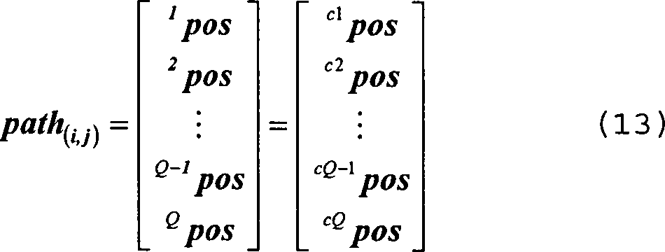
Hierbei
stellt jeder Eintrag eine zwei- bzw. dreidimensionale Position der
Messpunkte auf dem Pfad dar. Wie bereits erwähnt, sind die einzelnen Positionen
gleichmäßig beabstandet, so
dass der Abstand Δpath(i,j) zwischen aufeinander folgenden Positionen
im path(i,j) wie folgt berechnet werden
kann: ![]()
![]()
Um
eine gute Abdeckung der Orts-Feldstärkekarte durch abgelaufene
Pfade zu erreichen, wird eine so genannte Pfad-Kostenfunktion betrachtet, bei der zunächst die
Distanz von jeder angenommenen Position qpos
auf einem Pfad zu der nächsten
Basisstation betrachtet wird. Diese Distanz wird als qdBS bezeichnet und lautet wie folgt: 
Mit
Hilfe dieser Funktion wird ein Kostenwert Γpath für einen
Pfad dadurch berechnet, dass das Maximum aus allen Distanzen gemäß Gleichung
(15) für
einen Pfad zwischen den Basisstationen i und j ausgewählt ist.
Somit ergibt sich folgende Kostenfunktion: ![]()
![]()
Diese Pfad-Kostenfunktion gibt wieder, wie stark das Gebiet, durch das der Pfad verläuft, von Basisstationen entfernt ist. Um eine gute Kalibrierung zu erreichen, werden gemäß der hier beschriebenen Variante des erfindungsgemäßen Verfahrens zunächst Pfade mit hohen Pfadkosten durchlaufen. Das heißt, die Pfade werden in absteigender Reihenfolge ihrer Kosten durch das mobile Objekt durchlaufen. Es sei hierbei angemerkt, dass die Wahl der Pfade selbst durch bestimmte Einschränkungen beeinflusst werden kann, beispielsweise dadurch, dass zuvor bereits angenommene Positionen dynamisch bei der Berechnung neuer Pfadkosten berücksichtigt werden.These Path cost function returns how strong the area is by which the path runs, away from base stations. To achieve a good calibration, be according to the here described variant of the method according to the invention initially paths go through with high path costs. That is, the paths are in descending order Order of their costs through the mobile object go through. It It should be noted that the choice of paths themselves by certain restrictions can be influenced, for example, by the fact that previously assumed positions dynamically when calculating new path costs considered become.
Jeder Pfad kann nunmehr als ein Satz von Messpunkten betrachtet werden, wobei jeder dieser Messpunkte mit einem lokalen Fehler gemäß oben beschriebener Gleichung (6) verknüpft ist. Aus diesem Grund wird in der hier beschriebenen Ausführungsform ein Pfad als gesamtes betrachtet und blockweise adaptiert, wohingegen in der zuvor beschriebenen Ausführungsform nach jeder Ortung in einem Messpunkt eine Adaption der Orts-Feldstärkekarte erfolgen kann. In der nun beschriebenen Ausführungsform werden jedoch alle Positionen, welche zu einem betrachteten Pfad gehören, bei der Berechnung der Aktualisierungs-Fläche berücksichtigt. Somit findet die Aktualisierung immer erst nach dem Durchqueren eines Pfades durch das mobile Objekt statt.Each path can now be considered as a set of measurement points, each of these measurement points being associated with a local error according to equation (6) described above. For this reason, in the embodiment described here, a path is considered as a whole and adapted block by block, whereas in the embodiment described above, after each location in a measuring point, an adaptation of the local field strength map can take place. In the embodiment now described, however, all Positions which belong to a path under consideration are taken into account in the calculation of the update area. Thus, the update always takes place only after traversing a path through the mobile object.
In der hier beschriebenen Variante werden als Gewichtung des lokalen Fehlers wiederum die Gaußsche Fläche gemäß Gleichung (9) verwendet. Diese Fläche basiert auf dem zentralen Fehler, der durch die Gleichung (11) gegeben ist. Um alle Positionen auf einem Pfad zwischen den Basisstationen BSi und BSj gleichzeitig zu berücksichtigen, sind einige Modifikationen bei der Zusammensetzung der Aktualisierungs-Fläche gemacht worden.In The variant described here will be considered as weighting the local Error again the Gaussian area according to equation (9) used. This area is based on the central error given by equation (11) is. To all positions on a path between the base stations To consider BSi and BSj simultaneously, some modifications are made in the composition of the update surface Service.
Die erste Modifikation besteht darin, dass die Standardabweichung σ proportional zu dem gleichmäßigen Abstand zwischen den Positionen auf dem Pfad gemacht wurde, das heißt proportional zu Δpath(i,j). Es gilt somit σ = ϕ·Δpath(i,j). Dies bedeutet, dass jeder Pfad eine eigene Standardabweichung σ für ein festes ϕ aufweist, sofern Δpath(i,j) für jeden Pfad unterschiedlich ist.The first modification is that the standard deviation σ is proportional to the uniform distance between the positions taken on the path, that is proportional to Δpath (i, j). Thus, σ = φ · Δpath (i, j) . This means that each path has its own standard deviation σ for a fixed φ, as long as Δpath (i, j) is different for each path.
Die Sequenz der Positionen entlang des Pfads erzeugt eine Sequenz von Gaußglocken für jede Position auf dem Pfad, wobei die Gaußglocken miteinander überlappen. Es sollte deshalb eine Art von Normalisierung verwendet werden, um zu erreichen, dass die Summe aller Gaußglocken entlang des Pfads in den Grenzen der ursprünglichen lokalen Fehlerwerte auf der Aktualisierungs-Fläche liegt. Die hier verwendete Normalisierung basiert auf der so genannten "Partitioning-To-One-Normalisation", welche in radialen Netzwerken verwendet wird (siehe Druckschrift [3]).The Sequence of positions along the path generates a sequence of gaussian bells for every Position on the path, with the Gaussian bells overlapping each other. Therefore, some sort of normalization should be used to achieve that the sum of all Gaussian bells along the path in the limits of the original local error values lies on the update surface. The one used here Normalization is based on the so-called "partitioning-to-one normalization", which in radial Networks is used (see reference [3]).
Ähnlich zur
Gleichung (8) wird der Radius r für die zentrale Position cpos und für die q-te Position cqpos auf einem Pfad wie folgt als qr definiert: ![]()
![]()
Dementsprechend
modifiziert sich der in Gleichung (11) definierte lokale Fehler
für eine
Sequenz an Pfadpositionen cqpos wie folgt:
Unter
Verwendung von qr und qΔp in der
Gleichung (7) bzw. (9) ergibt sich als normalisierte Aktualisierungs-Fläche für die q-te
Pfadposition qpos und für die Basisstation n folgender
Term: 
Hierbei ist ζ ein positiver Term, um sicherzustellen, dass der Nenner niemals Null wird, was bedeutet, dass die normalisierten Gaußschen Oberflächen auch tatsächlich auf Null an Positionen in großer Entfernung vom Zentrum abfallen. Es ist hierbei insbesondere zu berücksichtigen, dass die Wahl von ζ auch Deformationen in der Oberfläche einführt. Falls ζ zu groß ist, reskaliert sich die Oberfläche zu kleineren Werten. Falls ζ zu klein ist, nimmt die Oberfläche rechteckige Formen anstatt einer Glocke an, obwohl die Oberfläche auf Eins nor malisiert ist. Es hat sich gezeigt, dass ein bevorzugter Wert für ζ bei 0,3 liegt.in this connection is ζ on positive term, to ensure that the denominator never zero which means that the normalized Gaussian surfaces, too indeed zero at positions in large Distance from the center. It is in particular too consider, that the choice of ζ too Deformations in the surface introduces. If ζ closed is great rescales the surface to smaller values. If ζ too small is, takes the surface Rectangular shapes instead of a bell, though the surface is on One is normalized. It has been shown that a preferred Value for ζ at 0.3 lies.
Der wesentliche Unterschied zwischen der soeben beschriebenen Kalibrierung mit dem PPS-Verfahren und der Kalibrierung mit unüberwachtem Lernen besteht darin, dass beim unüberwachten Lernen bei jeder neuen Messung des Feldstärkewerts cp die Position cpos ausschließlich aus dem bei der Ortung verwendeten Modell abgeleitet wird, insbesondere mit dem Fingerprinting-Verfahren. Dies bedeutet, dass die mit der ursprünglich verwendeten Orts-Feldstärkekarte abgeschätzten Positionen verwendet werden, um das Modell (das heißt die Orts-Feldstärkekarte) zu aktualisieren, und zwar ohne das Wissen über die tatsächliche Position des Objekts.The main difference between the just described calibration with the PPS method and the unsupervised learning calibration is that, with unsupervised learning, each time the field strength value c p is measured, the position c pos is derived exclusively from the model used in the location, in particular with the fingerprinting method. This means that the positions estimated using the originally used local field strength map are used to update the model (ie, the location field map) without knowing the actual position of the object.
Ein weiterer wichtiger Unterschied zwischen dem unüberwachten und dem überwachten Lernen besteht darin, dass beim unüberwachten Lernen die Messungen an jedem Ort in der Orts-Feldstärkekarte vorgenommen werden können und sich nicht nur auf direkte Pfade zwischen zwei Basisstationen beschränken, wie dies beim PPS-Verfahren der Fall ist. Es können somit mehr Punkte beim Lernen berücksichtigt werden.Another important difference between unsupervised and supervised learning is that in unsupervised learning, the measurements can be made anywhere in the location field map and not just limited to direct paths between two base stations, such as this is the case with the PPS procedure. It can thus be considered more points in learning.
Ein weiterer Unterschied besteht darin, dass beim unüberwachten Lernen die Aktualisierung der Orts-Feldstärkekarte bei jeder neuen Messung durchgeführt wird, wohingegen die Aktualisierung im PPS-Verfahren erst nach Durchlaufen eines Pfades durchgeführt werden kann.One Another difference is that in unsupervised learning, updating the location field strength map performed every new measurement whereas the update in the PPS procedure will only take place after a path can be.
Im Folgenden werden experimentelle Ergebnisse vorgestellt, welche auf von den Erfindern durchgeführte Experimente beruhen, mit welchen Objekte mit den zuvor beschriebenen Varianten des erfindungsgemäßen Verfahrens lokalisiert wurden.in the Following are experimental results presented on performed by the inventors Experiments are based on what objects with the previously described Variants of the method according to the invention were located.
Das erfindungsgemäße Verfahren wurde für unterschiedliche Umgebungen in Bürogebäuden getestet. Als anfängliches Modell wurde sowohl das radiale Modell als auch das DPM-Modell für jede Umgebung und sowohl für das überwachte Lernverfahren als auch für das unüberwachte Lernverfahren verwendet.The inventive method was for different environments tested in office buildings. As an initial one Model was both the radial model and the DPM model for each environment and as well as that supervised Learning method as well as for the unsupervised one Learning method used.
Zur Bestimmung des Lokalisationsfehlers wurde die gesamte Messung betrachtet. Es wurde der mittlere Fehler der Positionsabschätzung berechnet. Der Fehler selbst ist die Distanz zwischen der abgeschätzten Position und der tatsächlichen Position, bei der die Messung durchgeführt wurde. Jede Position wurde dreimal gemessen und hieraus wurde der Durchschnitt gebildet.to Determination of the localization error was considered the entire measurement. The mean error of the position estimate was calculated. The mistake itself is the distance between the estimated position and the actual one Position at which the measurement was taken. Every position was measured three times and from this the average was formed.
Für das überwachte Lernen wurde eine Orts-Feldstärkekarte auf der Basis eines regelmäßig beabstandeten Gitters verwendet, wobei jede Stützstelle von der anderen um einen Meter versetzt ist. Die tatsächlichen Messpositionen waren nicht exakt kollinear mit den direkten Pfaden zwischen den Basisstationen. Jedoch wurden die Positionen so gewählt, dass sie so nahe wie möglich an dem direkten Pfad lagen. Somit konnte davon ausgegangen werden, dass Δpath(i,j) für jeden Pfad konstant ist. Der Lokalisationsfehler wurde immer dann berechnet, wenn ein einzelner Pfad zwischen zwei Basisstationen durch das mobile Objekt abgelaufen worden ist. Bei den weiter unten erläuterten Diagrammen ist somit auf der Abszisse die Nummer des Pfads wiedergegeben.For supervised learning, a local field strength map based on a regularly spaced grid was used, with each interpolation point offset from the other by one meter. The actual measurement positions were not exactly collinear with the direct paths between the base stations. However, the positions were chosen to be as close as possible to the direct path. Thus it could be assumed that Δpath (i, j) is constant for each path. The localization error was calculated whenever a single path between two base stations was expired by the mobile object. In the diagrams explained below, the number of the path is thus reproduced on the abscissa.
Für das unüberwachte Lernen wurden die Stützstellen der Orts-Feldstärkekarte durch die tatsächlichen Messpositionen gebildet. Der Lokalisationsfehler wurde bei jeder neuen Messung berechnet. Die Messungen wurden zufällig aus einem Satz von Messungen gewählt, wobei wiederholte Messungen ohne Einschränkungen erlaubt waren. Sowohl für das überwachte als auch für das unüberwachte Lernen wurden die Kontrollparameter K und ϕ variiert.For the unsupervised Learning became the support points the location field strength map through the actual Measuring positions formed. The localization error was at each calculated new measurement. The measurements were random a set of measurements, where repeated measurements were allowed without restrictions. Either for the supervised as well as for the unsupervised one Learning the control parameters K and φ were varied.
Pfad
Nr. 1: von Basisstation BS8 nach Basisstation BS3
Pfad Nr.
2: von Basisstation BS3 nach Basisstation BS1
Pfad Nr. 3: von
Basisstation BS1 nach Basisstation BS8
Pfad Nr. 4: von Basisstation
BS8 nach Basisstation BS2
Pfad Nr. 5: von Basisstation BS2
nach Basisstation BS9
Pfad Nr. 6: von Basisstation BS9 nach
Basisstation BS8
Pfad Nr. 7: von Basisstation BS8 nach Basisstation
BS6
Pfad Nr. 8: von Basisstation BS6 nach Basisstation BS3
Pfad
Nr. 9: von Basisstation BS3 nach Basisstation BS2
Pfad Nr.
10: von Basisstation BS2 nach Basisstation BS1
Path # 1: from base station BS8 to base station BS3
Path no. 2: from base station BS3 to base station BS1
Path No. 3: from base station BS1 to base station BS8
Path # 4: from base station BS8 to base station BS2
Path No. 5: from base station BS2 to base station BS9
Path no. 6: from base station BS9 to base station BS8
Path no. 7: from base station BS8 to base station BS6
Path # 8: from base station BS6 to base station BS3
Path # 9: from base station BS3 to base station BS2
Path no. 10: from base station BS2 to base station BS1
Pfad Nr. 1: von Basisstation
BS2 nach Basisstation BS9
Pfad Nr. 2: von Basisstation BS9
nach Basisstation BS12
Pfad Nr. 3: von Basisstation BS12 nach
Basisstation BS8
Pfad Nr. 4: von Basisstation BS8 nach Basisstation
BS7
Pfad Nr. 5: von Basisstation BS7 nach Basisstation BS14
Pfad
Nr. 6: von Basisstation BS14 nach Basisstation BS12
Pfad Nr.
7: von Basisstation BS12 nach Basisstation BS13
Pfad Nr. 8:
von Basisstation BS13 nach Basisstation BS5
Pfad Nr. 9: von
Basisstation BS5 nach Basisstation BS11
Pfad Nr. 10: von Basisstation
BS11 nach Basisstation BS3.
Path # 1: from base station BS2 to base station BS9
Path no. 2: from base station BS9 to base station BS12
Path # 3: from base station BS12 to base station BS8
Path # 4: from base station BS8 to base station BS7
Path # 5: from base station BS7 to base station BS14
Path # 6: from base station BS14 to base station BS12
Path # 7: from base station BS12 to base station BS13
Path # 8: from base station BS13 to base station BS5
Path # 9: from base station BS5 to base station BS11
Path No. 10: from base station BS11 to base station BS3.
Wie sich aus den vorangegangenen Ausführungen ergibt, wird mit dem erfindungsgemäßen Lokalisationsverfahren eine sehr gute Lokalisations-Genauigkeit erreicht, wobei die Installations- und Instandhaltungskosten für das Verfahren sehr gering sind. Insbesondere ist keine anfängliche Kalibrierung des Verfahrens mit Hilfe von Referenzmessungen notwendig, da die Kalibrierung durch die Aktualisierung der Orts-Feldstärkekarte während des Verfahrens selbst durchgeführt wird. Das Verfahren beginnt hierbei mit einem anfänglichen Wellenausbreitungsmodell mit geringer Komplexität, dessen Parameter durch wenige Messungen, beispielsweise durch eine Selbstvermessung der Basisstationen, ermittelt wurden. Man erkennt, dass bei der Verwendung des DPM-Modells die Genauigkeit des Verfahrens besser ist als bei der Verwendung des einfachen radialen Modells. Die ursprünglichen Orts-Feldstärkekarten werden erfindungsgemäß während des Lernverfahrens online adaptiert, wobei zwischen einem unüberwachten Lernverfahren und einem überwachten Lernverfahren unterschieden wird. Beim unüberwachten Lernverfahren werden simultan die Lokalisation und die Aktualisierung der Orts- Feldstärkekarte durchgeführt. Demgegenüber wird beim überwachten Lernverfahren ein bekannter Pfad vorgegeben, auf dem sich das mobile Objekt bewegt. Die mit dem Verfahren erreichte Genauigkeit ist vergleichbar mit Lokalisations-Algorithmen, welche Referenzmessungen verwenden, wobei es in dem erfindungsgemäßen Verfahren jedoch nicht erforderlich ist, solche Referenzmessungen vor dem Start des Verfahrens durchzuführen.As is apparent from the foregoing, is with the Localization method according to the invention achieved a very good localization accuracy, whereby the installation and maintenance costs for the process is very low. In particular, no initial Calibration of the procedure with reference measurements necessary since the calibration by updating the location field strength map while the procedure itself becomes. The process starts with an initial wave propagation model with low complexity, its parameters by a few measurements, for example by a Self-measurement of the base stations, were determined. One recognises, that when using the DPM model, the accuracy of the process is better than using the simple radial model. The originals Location field-strength map are inventively during the Learning method adapted online, being between an unsupervised Learning process and a supervised Learning process is distinguished. When unsupervised learning process will be simultaneously the localization and updating of the local field strength map carried out. In contrast, is monitored Learning method given a known path on which the mobile Object moves. The accuracy achieved with the method is comparable with localization algorithms, which use reference measurements, wherein in the method according to the invention However, such reference measurements are not required prior to Start the procedure.
Literaturverzeichnis:Bibliography:
- [1] T. S. Rappaport, Wireless Communications Principles und Practice, 2nd Ed., Prentice Hall Inc., 2002.[1] TS Rappaport, Wireless Communications Principles and Practice, 2nd Ed., Prentice Hall Inc. 2002.
- [2] T. Kohonen, "The self-organizing map," Proceedings of the IEEE, vol. 78, no. 9, pp. 1464–1480, September 1990.[2] T. Kohonen, "The self-organizing map, "Proceedings of the IEEE, vol. 78, no. 9, pp. 1464-1480, September 1990.
- [3] M. Schlang, M. Haft und K. A. Fuchs, "A comparison of RBF and MLP networks for reconstruction of focal events from bioelectric/biomagnetic field patterns," in Mustererkennung 1994 Erkennen and Lernen, 16. DAGM Symposium and 18. Workshop of the ÖAGM, 1994.[3] M. Schlang, M. Haft and K.A. Fuchs, "A Comparison of RBF and MLP networks for reconstruction of focal events from bioelectric / biomagnetic field patterns, "in Pattern Recognition 1994 Recognize and Learn, 16th DAGM Symposium and 18th Workshop of the ÖAGM, 1994th
- [4] G. Wölfle, R. Wahl, P. Wertz, P. Wildbolz and F. Landstorfer, "Dominant path prediction model for indoor scenarios", German Microwave Conference (GeMIC) 2005, April 2005.[4] G. Wölfle, R. Wahl, P. Wertz, P. Wildbolz and F. Landstorfer, "Dominant path prediction model for indoor scenarios ", German Microwave Conference (GeMIC) 2005, April 2005.
- [5] G. Wölfle, and F. Landstorfer, "Dominant paths for the field strength prediction," 48th IEEE Vehicular Technology Conference (VTC) 1998, pp. 552–556, May 1998.[5] G. Wölfle, and F. Landstorfer, "Dominant paths for the field strength prediction," 48 th IEEE Vehicular Technology Conference (VTC) 1998, pp. 552-556, May 1998.
- [6] H. Wang, Fusion of Information Sources for Indoor Positioning with Field Strength Measurements, Master Thesis, TU-München, 2005.[6] H. Wang, Fusion of Information Sources for Indoor Positioning with Field Strength Measurements, Master Thesis, TU Munich, 2005.
- [7] M. Shimrat, "Algorithm 112: position of point relative to polygon," Communications of the ACM, vol. 5, no. 8, pp. 434, August 1962.[7] M. Shimrat, "Algorithm 112: position of point relative to polygon, "Communications of the ACM, vol. 5, no. 8, pp. 434, August 1962.
- [8] Robert W. Floyd, "Algorithm 97: shortest path," Communications of the ACM, vol. 5, no. 6, pp. 345, 1962.[8] Robert W. Floyd, "Algorithm 97: shortest path, "Communications of the ACM, vol. 5, no. 6, pp. 345, 1962.
Claims (26)

Priority Applications (5)
| Application Number | Priority Date | Filing Date | Title |
|---|---|---|---|
| AT06830564T ATE515167T1 (en) | 2006-03-31 | 2006-12-12 | METHOD AND DEVICE FOR DETERMINING THE LOCATION OF A MOBILE OBJECT |
| US11/991,588 US8102314B2 (en) | 2006-03-31 | 2006-12-12 | Method and apparatus for determining the location of a mobile object |
| PCT/EP2006/069616 WO2007118518A1 (en) | 2006-03-31 | 2006-12-12 | Method and apparatus for determining the location of a mobile object |
| EP06830564A EP2002680B1 (en) | 2006-03-31 | 2006-12-12 | Method and apparatus for determining the location of a mobile object |
| CN200680032561.3A CN101352061B (en) | 2006-03-31 | 2006-12-12 | For determining the on-site method and apparatus of mobile object |
Applications Claiming Priority (2)
| Application Number | Priority Date | Filing Date | Title |
|---|---|---|---|
| EP06006833 | 2006-03-31 | ||
| EP06006833 | 2006-03-31 |
Publications (1)
| Publication Number | Publication Date |
|---|---|
| DE102006044293A1 true DE102006044293A1 (en) | 2007-10-25 |
Family
ID=36764714
Family Applications (1)
| Application Number | Title | Priority Date | Filing Date |
|---|---|---|---|
| DE102006044293A Ceased DE102006044293A1 (en) | 2006-03-31 | 2006-09-20 | Computerized method for mobile object localization, involves measuring characteristics of number of base stations using reference map, where base station characterizes field transmitted by base station at object |
Country Status (6)
| Country | Link |
|---|---|
| US (1) | US8102314B2 (en) |
| EP (1) | EP2002680B1 (en) |
| CN (1) | CN101352061B (en) |
| AT (1) | ATE515167T1 (en) |
| DE (1) | DE102006044293A1 (en) |
| WO (1) | WO2007118518A1 (en) |
Cited By (8)
| Publication number | Priority date | Publication date | Assignee | Title |
|---|---|---|---|---|
| WO2009132915A1 (en) * | 2008-04-30 | 2009-11-05 | Siemens Aktiengesellschaft | Method for computer-aided localization of a mobile object using a feature-based positioning method |
| DE102008047212A1 (en) | 2008-06-09 | 2009-12-10 | Siemens Aktiengesellschaft | Method for computer-based localization of mobile object by multi-channel wireless local area network, involves transmitting field by mobile object, and partly receiving field by multiple base stations |
| DE102009016230A1 (en) | 2008-09-12 | 2010-03-25 | Siemens Aktiengesellschaft | Method and device for the computer-aided classification of measurements for the feature-based location of a mobile object in a predetermined area |
| DE102009055871A1 (en) | 2009-04-22 | 2010-10-28 | Siemens Aktiengesellschaft | Method for the computer-aided processing of measurements of features of a radio network |
| DE102010011982A1 (en) | 2009-09-29 | 2011-04-07 | Siemens Aktiengesellschaft | Method for the computer-aided creation and / or updating of a reference map for a satellite-based location of an object |
| EP2492707A1 (en) * | 2011-02-28 | 2012-08-29 | Mitsubishi Electric R&D Centre Europe B.V. | Method for determining a map of an area associated to a base station |
| DE102011007486A1 (en) * | 2011-04-15 | 2012-10-18 | Siemens Aktiengesellschaft | A method for computer-aided learning of a reference map based on measurements of features of a radio network |
| CN106383334A (en) * | 2016-08-31 | 2017-02-08 | 广西科技大学 | Mobile object detecting method based on sound waves and wireless positioning |
Families Citing this family (30)
| Publication number | Priority date | Publication date | Assignee | Title |
|---|---|---|---|---|
| US8948513B2 (en) * | 2009-01-27 | 2015-02-03 | Apple Inc. | Blurring based content recognizer |
| US9217788B2 (en) | 2009-03-19 | 2015-12-22 | Cork Institute Of Technology | Location and tracking system |
| US8812015B2 (en) | 2009-10-01 | 2014-08-19 | Qualcomm Incorporated | Mobile device locating in conjunction with localized environments |
| US9116003B2 (en) | 2009-10-01 | 2015-08-25 | Qualcomm Incorporated | Routing graphs for buildings |
| US8880103B2 (en) | 2009-10-12 | 2014-11-04 | Qualcomm Incorporated | Method and apparatus for transmitting indoor context information |
| US8698671B2 (en) * | 2009-10-16 | 2014-04-15 | Qualcomm Incorporated | Binning venues into categories based on propagation characteristics |
| US9389085B2 (en) | 2010-01-22 | 2016-07-12 | Qualcomm Incorporated | Map handling for location based services in conjunction with localized environments |
| CN102316478B (en) * | 2010-07-05 | 2014-07-16 | 宏碁股份有限公司 | Method for calculating current position, method for preventing communication device from being stolen and communication device |
| US8523075B2 (en) | 2010-09-30 | 2013-09-03 | Apple Inc. | Barcode recognition using data-driven classifier |
| US8905314B2 (en) | 2010-09-30 | 2014-12-09 | Apple Inc. | Barcode recognition using data-driven classifier |
| US9491604B2 (en) * | 2010-10-22 | 2016-11-08 | Blackberry Limited | Method and system for placing an emergency phone call from a mobile communication device to an enterprise |
| US8933841B2 (en) | 2010-12-13 | 2015-01-13 | The Governing Council Of The University Of Toronto | System and method for localization |
| CN102092591B (en) * | 2010-12-15 | 2013-01-09 | 中国神华能源股份有限公司 | Walking distance correction device of stacker |
| US9118776B2 (en) * | 2011-06-03 | 2015-08-25 | Apple Inc. | Location monitoring feature of a mobile device for activating an application subsystem |
| ITRM20110691A1 (en) * | 2011-12-29 | 2013-06-30 | Bruno Biscontini | PROCEDURE FOR LOCALIZING A TARGET IN A CLOSED ENVIRONMENT. |
| WO2013149378A1 (en) * | 2012-04-05 | 2013-10-10 | Telefonaktiebolaget L M Ericsson (Publ) | Positioning accuracy estimation |
| CN102711239B (en) * | 2012-05-10 | 2015-07-15 | 电子科技大学 | RSS (received signal strength) fingerprint database based secondary fuzzy clustering indoor-positioning method |
| CN103796301A (en) * | 2012-10-30 | 2014-05-14 | 北京清科时代科技有限公司 | Method of correcting positioning position error |
| US9677890B2 (en) * | 2013-01-10 | 2017-06-13 | Intel Corporation | Positioning and mapping based on virtual landmarks |
| CN103501538B (en) * | 2013-10-12 | 2016-03-30 | 清华大学 | Based on the indoor orientation method of multipath energy fingerprint |
| CN103561463B (en) * | 2013-10-24 | 2016-06-29 | 电子科技大学 | A kind of RBF neural indoor orientation method based on sample clustering |
| US20150330795A1 (en) * | 2014-05-15 | 2015-11-19 | Qualcomm Incorporated | Method to Dynamically Adjust Assistance Data for Improved Indoor Positioning Performance |
| CN104640205B (en) * | 2015-02-09 | 2018-08-28 | 重庆邮电大学 | The mobile phone positioning system and method for field strength and difference fingerprint are utilized under the conditions of macro base station |
| WO2017039495A1 (en) | 2015-08-31 | 2017-03-09 | Telefonaktiebolaget Lm Ericsson (Publ) | Method and network node for deciding a probability that a first user equipment is located in a building |
| CN107330429B (en) * | 2017-05-17 | 2021-03-09 | 北京捷通华声科技股份有限公司 | Certificate item positioning method and device |
| KR102121274B1 (en) * | 2018-05-10 | 2020-06-10 | 한양대학교 산학협력단 | Method for estimating analytic weight least squrares based on robust filter, unsupervised clustering |
| TWI674425B (en) * | 2018-07-09 | 2019-10-11 | 佐臻股份有限公司 | Device for accurately establishing the relative and absolute position of the 3D space in the space |
| CN110460965B (en) * | 2019-06-27 | 2021-09-07 | 星贝瑞有限公司 | System for dynamically identifying mobile device responding by radio signal and method thereof |
| GB2596824B (en) * | 2020-07-07 | 2022-11-30 | CellXion Ltd | Restricting access to a mobile communications network |
| EP4319235A1 (en) | 2022-08-05 | 2024-02-07 | Siemens Aktiengesellschaft | A method for teaching an electronic computing device, a computer program product, a computer-readable storage medium as well as an electronic computing device |
Family Cites Families (12)
| Publication number | Priority date | Publication date | Assignee | Title |
|---|---|---|---|---|
| GB2311697B (en) * | 1996-03-22 | 1999-07-28 | Matsushita Electric Ind Co Ltd | Wireless communication system and method and system for detection of position of radio mobile station |
| GB2337386B (en) * | 1996-09-09 | 2001-04-04 | Dennis J Dupray | Location of a mobile station |
| US6269246B1 (en) * | 1998-09-22 | 2001-07-31 | Ppm, Inc. | Location determination using RF fingerprinting |
| US6839560B1 (en) * | 1999-02-25 | 2005-01-04 | Microsoft Corporation | Using a derived table of signal strength data to locate and track a user in a wireless network |
| US6799047B1 (en) * | 1999-02-25 | 2004-09-28 | Microsoft Corporation | Locating and tracking a user in a wireless network through environmentally profiled data |
| GB0105910D0 (en) * | 2001-03-09 | 2001-04-25 | Cellular Design Services Ltd | Measurement-based prediction method for radiation path loss |
| ATE365337T1 (en) * | 2001-09-05 | 2007-07-15 | Newbury Networks Inc | POSITION DETECTION AND LOCATION TRACKING IN A WIRELESS NETWORK |
| US6832090B2 (en) * | 2001-09-10 | 2004-12-14 | Qualcomm Incorporated | System and method for identification of transmitters with limited information |
| US7406116B2 (en) * | 2003-03-28 | 2008-07-29 | University Of Maryland | Method and system for determining user location in a wireless communication network |
| US7116988B2 (en) * | 2004-03-16 | 2006-10-03 | Airespace, Inc. | Location of wireless nodes using signal strength weighting metric |
| US7359718B2 (en) * | 2004-04-30 | 2008-04-15 | Hong Kong Applied Science And Technology Research Institute Co., Ltd. | Location determination and location tracking in wireless networks |
| WO2006017266A2 (en) * | 2004-07-12 | 2006-02-16 | William Marsh Rice University | System and method for localization over a wireless network |
-
2006
- 2006-09-20 DE DE102006044293A patent/DE102006044293A1/en not_active Ceased
- 2006-12-12 US US11/991,588 patent/US8102314B2/en not_active Expired - Fee Related
- 2006-12-12 AT AT06830564T patent/ATE515167T1/en active
- 2006-12-12 WO PCT/EP2006/069616 patent/WO2007118518A1/en active Application Filing
- 2006-12-12 EP EP06830564A patent/EP2002680B1/en not_active Not-in-force
- 2006-12-12 CN CN200680032561.3A patent/CN101352061B/en not_active Expired - Fee Related
Cited By (17)
| Publication number | Priority date | Publication date | Assignee | Title |
|---|---|---|---|---|
| DE102008038451A1 (en) | 2008-04-30 | 2009-11-05 | Siemens Aktiengesellschaft | Method for the computer-assisted localization of a mobile object with the aid of a feature-based locating method |
| WO2009132915A1 (en) * | 2008-04-30 | 2009-11-05 | Siemens Aktiengesellschaft | Method for computer-aided localization of a mobile object using a feature-based positioning method |
| DE102008047212B4 (en) * | 2008-06-09 | 2012-04-26 | Siemens Aktiengesellschaft | Method and device for the computer-assisted localization of a mobile object |
| DE102008047212A1 (en) | 2008-06-09 | 2009-12-10 | Siemens Aktiengesellschaft | Method for computer-based localization of mobile object by multi-channel wireless local area network, involves transmitting field by mobile object, and partly receiving field by multiple base stations |
| DE102009016230A1 (en) | 2008-09-12 | 2010-03-25 | Siemens Aktiengesellschaft | Method and device for the computer-aided classification of measurements for the feature-based location of a mobile object in a predetermined area |
| US8630235B2 (en) | 2008-09-12 | 2014-01-14 | Siemens Aktiengesellschaft | Method and apparatus for the computer-aided classification of measurements for the feature-based positioning of a mobile object in a predetermined region |
| DE102009016230B4 (en) * | 2008-09-12 | 2013-12-19 | Siemens Aktiengesellschaft | Method and device for the feature-based location of a mobile object by means of a reference card or for the unsupervised learning of a reference card for feature-based location |
| DE102009055871A1 (en) | 2009-04-22 | 2010-10-28 | Siemens Aktiengesellschaft | Method for the computer-aided processing of measurements of features of a radio network |
| WO2010121915A3 (en) * | 2009-04-22 | 2011-03-24 | Siemens Aktiengesellschaft | Method for the computer-assisted processing of measurements of features in a radio network |
| WO2010121915A2 (en) | 2009-04-22 | 2010-10-28 | Siemens Aktiengesellschaft | Method for the computer-assisted processing of measurements of features in a radio network |
| US9069053B2 (en) | 2009-04-22 | 2015-06-30 | Siemens Aktiengesellschaft | Method for the computer-assisted processing of measurements of features in a radio network |
| WO2011038976A1 (en) | 2009-09-29 | 2011-04-07 | Siemens Aktiengesellschaft | Method for the computer-supported creation and/or updating of a reference map for a satellite-supported positioning of an object |
| DE102010011982A1 (en) | 2009-09-29 | 2011-04-07 | Siemens Aktiengesellschaft | Method for the computer-aided creation and / or updating of a reference map for a satellite-based location of an object |
| EP2492707A1 (en) * | 2011-02-28 | 2012-08-29 | Mitsubishi Electric R&D Centre Europe B.V. | Method for determining a map of an area associated to a base station |
| DE102011007486A1 (en) * | 2011-04-15 | 2012-10-18 | Siemens Aktiengesellschaft | A method for computer-aided learning of a reference map based on measurements of features of a radio network |
| DE102011007486B4 (en) * | 2011-04-15 | 2015-03-26 | Siemens Aktiengesellschaft | A method for computer-aided learning of a reference map based on measurements of features of a radio network |
| CN106383334A (en) * | 2016-08-31 | 2017-02-08 | 广西科技大学 | Mobile object detecting method based on sound waves and wireless positioning |
Also Published As
| Publication number | Publication date |
|---|---|
| EP2002680B1 (en) | 2011-06-29 |
| CN101352061A (en) | 2009-01-21 |
| WO2007118518A1 (en) | 2007-10-25 |
| US20100103048A1 (en) | 2010-04-29 |
| CN101352061B (en) | 2016-05-04 |
| EP2002680A1 (en) | 2008-12-17 |
| ATE515167T1 (en) | 2011-07-15 |
| US8102314B2 (en) | 2012-01-24 |
Similar Documents
| Publication | Publication Date | Title |
|---|---|---|
| EP2002680B1 (en) | Method and apparatus for determining the location of a mobile object | |
| EP2335442B1 (en) | Apparatus and method for estimating an orientation of a mobile terminal | |
| DE69927256T2 (en) | METHOD AND RADIO SYSTEM FOR CALCULATING THE TIME DIFFERENCE BETWEEN TRANSMITTERS | |
| EP1769261B1 (en) | Device and method for determining the current position of a mobile device | |
| DE69928333T2 (en) | Pattern recognition based position determination | |
| DE602004005970T2 (en) | OBJECT POSITIONING | |
| DE602004002854T2 (en) | SYSTEM AND METHOD FOR SPEKTRAL CORRECTED FLASH DETECTION | |
| DE602004012119T2 (en) | METHOD AND DEVICE FOR USING A GEOGRAPHIC POSITION FOR DETERMINING WHEN TO BE EXITED FROM AN EXISTING WIRELESS COMMUNICATIONS COVERING NETWORK | |
| EP1606965B1 (en) | Method and device for adapting a radio network model to the conditions of a real radio network | |
| EP1917820B1 (en) | Method and arrangement for determination of radio coverage in a multi-cellular mobile radio system | |
| DE10196811T5 (en) | Algorithm for locating a remote terminal | |
| DE102013104727A1 (en) | Method and apparatus for determining the position of a mobile communication device | |
| DE102013003176A1 (en) | PROCESS AND DEVICE FOR POSITION DETERMINATION USING QUASI-FINGERPRINTING | |
| DE102009049672A1 (en) | Concept for generating experiences to update a reference database | |
| EP2385389A1 (en) | Device and method for calibrating a radio-based position determining device | |
| DE4207290C2 (en) | Method for assigning frequencies to transmitters for picocellular radio networks | |
| DE112019001979T5 (en) | REAL-TIME SPREADING ANALYSIS FOR COMMUNICATION SYSTEMS | |
| DE102018001499B3 (en) | Radar device with array antenna and method for source localization by a two-dimensional Radargruppenantenne | |
| DE60318128T2 (en) | METHOD FOR PRODUCING SHUTTERS BASED ON THE POSITION OF A MOBILE OPERATING DEVICE IN A MOBILE RADIO NETWORK, MOBILE RADIO NETWORK AND COMPUTER PROGRAM THEREFOR | |
| DE60303031T2 (en) | Method and system for assessing interference between cells in the upward direction | |
| EP2150833A1 (en) | Device for determining a device position | |
| DE112004002467T5 (en) | Method and device for locating a decentralized unit | |
| DE102007042019B4 (en) | Method and device for position determination and navigation | |
| DE102019110998A1 (en) | Vehicle Positioning System Arrangements, System, Use and Method | |
| DE112022001966T5 (en) | BASE STATION, RADIO COMMUNICATION METHOD AND RADIO COMMUNICATION SYSTEM |
Legal Events
| Date | Code | Title | Description |
|---|---|---|---|
| OP8 | Request for examination as to paragraph 44 patent law | ||
| R002 | Refusal decision in examination/registration proceedings | ||
| R003 | Refusal decision now final |
Effective date: 20121110 |
|
| R081 | Change of applicant/patentee |
Owner name: SIEMENS ENTERPRISE COMMUNICATIONS GMBH & CO. K, DE Free format text: FORMER OWNER: SIEMENS AKTIENGESELLSCHAFT, 80333 MUENCHEN, DE Effective date: 20130314 |
|
| R082 | Change of representative |
Representative=s name: FRITZSCHE PATENT, DE Effective date: 20130314 Representative=s name: FRITZSCHE PATENTANWAELTE, DE Effective date: 20130314 |