CN201837726U - Locator capable of networking with low power consumption based on single-chip microcomputer (SCM) - Google Patents
Locator capable of networking with low power consumption based on single-chip microcomputer (SCM) Download PDFInfo
- Publication number
- CN201837726U CN201837726U CN2010205798195U CN201020579819U CN201837726U CN 201837726 U CN201837726 U CN 201837726U CN 2010205798195 U CN2010205798195 U CN 2010205798195U CN 201020579819 U CN201020579819 U CN 201020579819U CN 201837726 U CN201837726 U CN 201837726U
- Authority
- CN
- China
- Prior art keywords
- module
- chip microcomputer
- sensor
- data transmission
- wireless data
- Prior art date
- Legal status (The legal status is an assumption and is not a legal conclusion. Google has not performed a legal analysis and makes no representation as to the accuracy of the status listed.)
- Expired - Fee Related
Links
Images


Classifications
-
- Y—GENERAL TAGGING OF NEW TECHNOLOGICAL DEVELOPMENTS; GENERAL TAGGING OF CROSS-SECTIONAL TECHNOLOGIES SPANNING OVER SEVERAL SECTIONS OF THE IPC; TECHNICAL SUBJECTS COVERED BY FORMER USPC CROSS-REFERENCE ART COLLECTIONS [XRACs] AND DIGESTS
- Y02—TECHNOLOGIES OR APPLICATIONS FOR MITIGATION OR ADAPTATION AGAINST CLIMATE CHANGE
- Y02D—CLIMATE CHANGE MITIGATION TECHNOLOGIES IN INFORMATION AND COMMUNICATION TECHNOLOGIES [ICT], I.E. INFORMATION AND COMMUNICATION TECHNOLOGIES AIMING AT THE REDUCTION OF THEIR OWN ENERGY USE
- Y02D30/00—Reducing energy consumption in communication networks
- Y02D30/70—Reducing energy consumption in communication networks in wireless communication networks
Landscapes
- Position Fixing By Use Of Radio Waves (AREA)
- Testing Or Calibration Of Command Recording Devices (AREA)
Abstract
本实用新型涉及一种基于单片机的低功耗可组网定位仪。含有控制模块、GPS模块、无线数据传输模块、传感器模块、显示及报警模块,所述控制模块采用51系列的任一种单片机,控制模块外接GPS模块、无线数据传输模块、传感器模块、显示及报警模块,所述无线数据传输模块选用多通道微功率嵌入式无线数传模块;传感器模块包括MEMS压力传感器和地磁传感器;GPS模块、MEMS压力传感器和地磁传感器传感器采集气压、温度和地磁信息传输到控制模块,核心处理器将采集的各种信息进行综合处理并通过无线数据传输模块将信息传到网络上各节点设备,并通过显示模块显示。本实用新型定位仪既能测出所在地三维空间信息,又能测出温度、气压,可为用户提供更加实用快捷的服务。
The utility model relates to a single-chip microcomputer-based low-power-consumption networkable locator. Contains control module, GPS module, wireless data transmission module, sensor module, display and alarm module, the control module adopts any single chip microcomputer of 51 series, and the control module is externally connected with GPS module, wireless data transmission module, sensor module, display and alarm module, the wireless data transmission module selects a multi-channel micropower embedded wireless data transmission module; the sensor module includes a MEMS pressure sensor and a geomagnetic sensor; Module, the core processor will comprehensively process the various information collected and transmit the information to each node device on the network through the wireless data transmission module, and display it through the display module. The locator of the utility model can not only measure the three-dimensional space information of the location, but also can measure the temperature and air pressure, and can provide users with more practical and efficient services.
Description
技术领域technical field
本实用新型涉及一种定位仪,特别是涉及一种基于单片机的低功耗可组网定位仪。 The utility model relates to a locator, in particular to a low power consumption and networkable locator based on a single-chip microcomputer. the
背景技术Background technique
随着GPS(英文Global Position System的字头简称,即全球定位系统,利用导航卫星为全球用户提供实时的、高精度的三维速度的时间信息)应用研究的不断深入, 大量GPS 用户设备已用于舰船、飞机的导航、导弹卫星测控、精密授时、作战训练、石油资源开发等方面。近年来, 车辆的跟踪和导航、农业、公安和旅游等也纳入GPS 的应用范围。目前作为GPS 典型集成应用系统(如个人导航系统、GPS车辆监控系统等)的核心技术,都涉及到如何在移动环境下完成GPS数据的采集与无线网络传输。国内外对该技术的实现主要是采用笔记本电脑、PDA 或价精密专用硬件作为硬件平台,以及GPS、GPRS或GSM 等相关外设。由于系统涉及的硬件较多,项目投资和开发周期较长,后期运营成本高,因此这些系统只能应用于某些行业,使用受到限制。 With the continuous deepening of GPS (the abbreviation of the prefix of Global Position System in English, that is, Global Positioning System, which uses navigation satellites to provide real-time, high-precision three-dimensional speed time information for global users), a large number of GPS user equipment has been used Ship and aircraft navigation, missile satellite measurement and control, precision timing, combat training, oil resource development, etc. In recent years, vehicle tracking and navigation, agriculture, public security and tourism have also been included in the scope of GPS applications. At present, as the core technology of typical GPS integrated application systems (such as personal navigation systems, GPS vehicle monitoring systems, etc.), all involve how to complete GPS data collection and wireless network transmission in a mobile environment. The realization of this technology at home and abroad mainly uses notebook computers, PDAs or high-precision special hardware as the hardware platform, and related peripherals such as GPS, GPRS or GSM. Due to the large amount of hardware involved in the system, long project investment and development cycle, and high post-operation costs, these systems can only be applied to certain industries and their use is limited. the
实用新型内容Utility model content
本实用新型针对现有的GPS定位仪价格高、功能不够完善、操作麻烦且无法免费通信的不足,提出一种基于单片机的低功耗可组网定位仪,既能测得所处位置的三维空间信息和气压、温度环境信息,又能通过无线数传进行小流量数据通信,将各种信息传输到同一网络的其他定位仪上。 The utility model aims at the deficiencies of the existing GPS locator, such as high price, insufficient functions, cumbersome operation and inability to communicate for free, and proposes a single-chip microcomputer-based low-power-consumption networkable locator, which can measure the three-dimensional position of the location. Spatial information, air pressure, temperature environment information, and small flow data communication can be carried out through wireless data transmission, and various information can be transmitted to other locators on the same network. the
本实用新型所采用的技术方案: The technical scheme adopted in the utility model:
一种基于单片机的低功耗可组网定位仪,含有控制模块、GPS模块、无线数据传输模块、传感器模块、显示及报警模块,所述控制模块采用51系列任一种单片机为核心处理器,控制模块外接GPS模块、无线数据传输模块、传感器模块、显示及报警模块,所述无线数据传输模块选用多通道微功率嵌入式无线数传模块;传感器模块包括MEMS压力传感器和地磁传感器;控制模块连接显示及报警模块并通过无线数据传输模块将信息传到网络上各节点设备。A single-chip microcomputer-based low-power network locator, including a control module, a GPS module, a wireless data transmission module, a sensor module, a display and an alarm module, and the control module uses any single-chip microcomputer of the 51 series as the core processor, The control module is externally connected with a GPS module, a wireless data transmission module, a sensor module, a display and an alarm module, and the wireless data transmission module selects a multi-channel micropower embedded wireless data transmission module; the sensor module includes a MEMS pressure sensor and a geomagnetic sensor; the control module connects The display and alarm module transmits the information to each node device on the network through the wireless data transmission module.
所述的基于单片机的低功耗可组网定位仪,GPS模块选用C3-470CGPS模块;无线数据传输模块选用多通道微功率嵌入式无线数传模块APC230-43;控制模块核心处理器采用中国宏晶公司的STC12C5A60S2单片机,所述单片机外接存储电路、按键控制电路、震荡电路、复位电路,存储电路采用 AT24c1024存储器;GPS模块和无线数据传输模块分别通过相应的控制端口和数据端口连接单片机。 For the low-power network locator based on the single-chip microcomputer, the GPS module selects the C3-470CGPS module; the wireless data transmission module selects the multi-channel micropower embedded wireless data transmission module APC230-43; the core processor of the control module adopts China Acer The STC12C5A60S2 single-chip microcomputer of Jing Company, the single-chip microcomputer is externally connected with a storage circuit, a button control circuit, an oscillation circuit, and a reset circuit, and the storage circuit adopts an AT24c1024 memory; the GPS module and the wireless data transmission module are respectively connected to the single-chip microcomputer through corresponding control ports and data ports. the
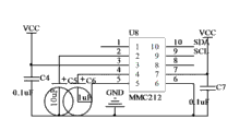
所述的基于单片机的低功耗可组网定位仪,MEMS压力传感器采用BMP085,地磁传感器采用MEMS两轴磁传感器MMC212;压力传感器BMP085通过I2C总线直接与处理器相连,(测量大气压以及环境温度,并通过气压矫正高度);地磁传感器通过相应的控制端口和数据端口连接单片机,测量所在处磁场在X,Y方向的分量信息,由单片机通过算法得到北极方向。 The low-power networkable locator based on the single-chip microcomputer, the MEMS pressure sensor adopts BMP085, the geomagnetic sensor adopts MEMS two-axis magnetic sensor MMC212; the pressure sensor BMP085 is directly connected to the processor through the I 2 C bus, (measures atmospheric pressure and environment Temperature, and the altitude is corrected by air pressure); the geomagnetic sensor is connected to the single-chip microcomputer through the corresponding control port and data port, and measures the component information of the magnetic field in the X and Y directions where it is located, and the north pole direction is obtained by the single-chip microcomputer through an algorithm.
所述的基于单片机的低功耗可组网定位仪,传感器模块包括加速度传感器,所述加速度传感器采用美国Freescale公司的一款单芯片MMA7260三轴加速度传感器;所述加速度传感器分别通过相应的控制端口和数据端口连接单片机。 In the low-power consumption networking locator based on the single-chip microcomputer, the sensor module includes an acceleration sensor, and the acceleration sensor adopts a single-chip MMA7260 three-axis acceleration sensor from Freescale Corporation of the United States; the acceleration sensor passes through the corresponding control port respectively. Connect the microcontroller with the data port. the
所述的基于单片机的低功耗可组网定位仪,显示及报警模块中显示模块采用NOKIA 5110 LCD液晶显示屏,所述LCD液晶显示屏采用串行接口与单片机通讯连接,报警模块采用一扬声器接入一级放大器电路,所述放大器控制基极通过一耦合电阻连接单片机的相应I/0输出端口。 In the low power consumption networking locator based on the single-chip microcomputer, the display module in the display and alarm module adopts a NOKIA 5110 LCD liquid crystal display, and the LCD liquid crystal display adopts a serial interface to communicate with the single-chip microcomputer, and the alarm module adopts a loudspeaker A primary amplifier circuit is connected, and the control base of the amplifier is connected to the corresponding I/0 output port of the single-chip microcomputer through a coupling resistor. the
本实用新型的有益积极效果: Beneficial positive effects of the utility model:
1、本实用新型基于单片机的低功耗可组网定位仪,将无线传感器网络技术应用到传统的空间信息服务中,既能获取空间信息又能获取环境参数,还能进行免费通信。本实用新型将革命性的改变传统的基于位置的服务机制,使作为主体的人、作为客体的真实世界以及经由网络传输的数字世界三者无缝的结合起来,实现不受任何时间和空间局限的互动,最终目的是根本性地改变人与数字地球、人与现实世界的交互方式,能够为任何基于空间的作业系统如导航、数字战场、智能交通、旅游、探险、娱乐等提供全新的作业模式。应用领域和应用前景将更加广阔。1. The utility model is a single-chip microcomputer-based low-power networkable locator, and applies wireless sensor network technology to traditional spatial information services. It can obtain both spatial information and environmental parameters, as well as free communication. The utility model revolutionizes the traditional location-based service mechanism, seamlessly combines the person as the subject, the real world as the object, and the digital world transmitted through the network, and realizes that it is not limited by any time and space. The ultimate goal is to fundamentally change the interaction between people and the digital earth, and between people and the real world, and can provide new operations for any space-based operating system such as navigation, digital battlefield, intelligent transportation, tourism, exploration, entertainment, etc. model. The application field and application prospect will be broader.
2、本实用新型基于单片机的低功耗可组网定位仪,既能测出所在地三维空间信息,又能测出温度、气压,最终通过由无线数传构建的优先级主站授权无线网络,将信息传输到其他设备上。可为用户提供更加实用快捷的服务。采用的单片机和传感器等各功能模块均具备功耗低、体积小的特点,采用常用3.7V手机锂电池可轻松满足需求,使本定位仪常时间稳定运行。 2. The utility model is a single-chip microcomputer-based low-power networkable locator, which can not only measure the three-dimensional space information of the location, but also measure the temperature and air pressure, and finally authorize the wireless network through the priority master station constructed by wireless data transmission. Transfer information to other devices. It can provide users with more practical and efficient services. The single-chip microcomputer and sensor and other functional modules used have the characteristics of low power consumption and small size. The common 3.7V mobile phone lithium battery can easily meet the demand, so that the locator can run stably for a long time. the
附图说明Description of drawings
图1:本实用新型基于单片机的低功耗可组网定位仪原理框图; Figure 1: The principle block diagram of the utility model-based single-chip microcomputer-based low-power network locator;
图2:可组网定位仪控制模块电路原理示意图;Figure 2: Schematic diagram of the circuit principle of the control module of the networkable locator;
图3:GPS模块与单片机的接口电路;Figure 3: The interface circuit between the GPS module and the microcontroller;
图4:无线数据传输模块与单片机的接口电路;Figure 4: The interface circuit between the wireless data transmission module and the microcontroller;
图5:压力传感器模块BMP085电路原理图;Figure 5: Circuit schematic diagram of pressure sensor module BMP085;
图6:两轴地磁传感器MMC212电路原理图;Figure 6: Circuit schematic diagram of two-axis geomagnetic sensor MMC212;
图7:三轴加速度传感器电路原理图;Figure 7: Schematic diagram of the triaxial acceleration sensor circuit;
图8:显示及报警模块及其与单片机的接口电路。Figure 8: Display and alarm module and its interface circuit with microcontroller.
具体实施方式Detailed ways
实施例一:参见图1,本实用新型基于单片机的低功耗可组网定位仪,含有控制模块、GPS模块、无线数据传输模块、传感器模块、显示及报警模块,所述控制模块采用51系列的任一种单片机为核心处理器,控制模块外接GPS模块、无线数据传输模块、传感器模块、显示及报警模块,所述无线数据传输模块选用多通道微功率嵌入式无线数传模块;传感器模块包括MEMS压力传感器和地磁传感器;控制模块通过核心处理器将GPS模块、传感器模块采集的各种信息进行综合处理,通过无线数据传输模块将信息传到网络上各节点设备,并将处理得到的三维、气压、高度信息通过显示模块显示。 Embodiment 1: Referring to Figure 1, the utility model is based on a single-chip microcomputer-based low-power network locator, including a control module, a GPS module, a wireless data transmission module, a sensor module, a display and an alarm module, and the control module adopts 51 series Any single-chip microcomputer is the core processor, and the control module is externally connected to a GPS module, a wireless data transmission module, a sensor module, a display and an alarm module, and the wireless data transmission module is selected from a multi-channel micropower embedded wireless data transmission module; the sensor module includes MEMS pressure sensor and geomagnetic sensor; the control module comprehensively processes various information collected by the GPS module and sensor module through the core processor, transmits the information to each node device on the network through the wireless data transmission module, and transfers the processed 3D, Air pressure and altitude information are displayed through the display module. the
实施例二:参见图2~图6,图8。本实施例基于单片机的低功耗可组网定位仪,GPS模块选用C3-470CGPS模块;无线数据传输模块选用多通道微功率嵌入式无线数传模块APC230-43;控制模块核心处理器采用中国宏晶公司的STC12C5A60S2单片机,所述单片机外接存储电路、按键控制电路、震荡电路、复位电路,存储电路采用 AT24c1024存储器;GPS模块和无线数据传输模块分别通过相应的控制端口和数据端口连接单片机。 MEMS压力传感器采用BMP085,地磁传感器采用MEMS两轴磁传感器MMC212;压力传感器BMP085通过I2C总线直接与处理器相连,(测量大气压以及环境温度,并通过气压矫正高度);地磁传感器通过相应的控制端口和数据端口连接单片机,测量所在处磁场在X,Y方向的分量信息,由单片机通过算法得到北极方向。显示及报警模块中显示模块采用NOKIA 5110 LCD液晶显示屏,所述LCD液晶显示屏采用串行接口与单片机通讯连接,报警模块采用一扬声器接入一级放大器电路,所述放大器控制基极通过一耦合电阻连接单片机的相应I/0输出端口。 Embodiment 2: Refer to Fig. 2 to Fig. 6 and Fig. 8 . This embodiment is based on a single-chip microcomputer-based low-power network locator. The GPS module uses the C3-470CGPS module; the wireless data transmission module uses the multi-channel micropower embedded wireless data transmission module APC230-43; The STC12C5A60S2 single-chip microcomputer of Crystal Company, the single-chip microcomputer is externally connected with a storage circuit, a button control circuit, an oscillation circuit, and a reset circuit, and the storage circuit adopts an AT24c1024 memory; the GPS module and the wireless data transmission module are respectively connected to the single-chip microcomputer through corresponding control ports and data ports. The MEMS pressure sensor adopts BMP085, and the geomagnetic sensor adopts MEMS two-axis magnetic sensor MMC212; the pressure sensor BMP085 is directly connected to the processor through the I 2 C bus (measures atmospheric pressure and ambient temperature, and corrects the altitude through air pressure); the geomagnetic sensor is controlled by the corresponding The port and the data port are connected to the single-chip microcomputer, and the component information of the magnetic field in the X and Y directions is measured, and the north pole direction is obtained by the single-chip microcomputer through an algorithm. In the display and alarm module, the display module adopts a NOKIA 5110 LCD liquid crystal display, and the LCD liquid crystal display adopts a serial interface to communicate with the single-chip computer. The coupling resistor is connected to the corresponding I/0 output port of the microcontroller.
实施例三:本实施例基于单片机的低功耗可组网定位仪,与实施例二不同的是:传感器模块包括加速度传感器,所述加速度传感器采用美国Freescale公司的一款单芯片MMA7260三轴加速度传感器;所述加速度传感器分别通过相应的控制端口和数据端口连接单片机。 Embodiment 3: This embodiment is based on a single-chip microcomputer-based low-power network locator. The difference from
控制模块包括核心处理器、外围存储电路、按键控制电路、震荡电路、复位电路;核心处理器采用中国宏晶公司的增强型51单片机STC12C5A60S2作为核心处理器,该单片机采用宏晶第六代加密技术无法解密,超强抗干扰能力,速度快,多IO口(双串口,集成AD转换),片内RAM存储量大,支持掉电唤醒功能,超低功耗,适用于电池供电系统。价格低廉,功能强大,非常适合用于便携设备上。外围存储器采用 AT24c1024 1,048,576bits超大存储、I2C数据通信,具有掉电保护功能,方便存储查询、记录数据。采用五个按键(S1上翻键、S2下翻键、S3选择键、S4返回键、S5 ok键)完成对探测仪的整体操作,还能通过传感器模块的三轴加速度传感器进行简单换屏显示,方便快捷。 The control module includes a core processor, a peripheral storage circuit, a key control circuit, an oscillation circuit, and a reset circuit; the core processor adopts the enhanced 51 single-chip microcomputer STC12C5A60S2 of China Hongjing Company as the core processor, and the single-chip microcomputer adopts the sixth generation of encryption technology of Hongjing Unable to decrypt, super anti-interference ability, fast speed, multiple IO ports (dual serial ports, integrated AD conversion), large on-chip RAM storage capacity, support power-down wake-up function, ultra-low power consumption, suitable for battery-powered systems. Inexpensive, powerful, very suitable for use on portable devices. The peripheral memory adopts AT24c1024 1,048,576bits super large storage, I 2 C data communication, and has power-down protection function, which is convenient for storing, querying and recording data. Five keys (S1 up key, S2 down key, S3 selection key, S4 return key, S5 ok key) are used to complete the overall operation of the detector, and the three-axis acceleration sensor of the sensor module can also be used to simply change the screen display ,Convenient.
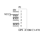
GPS具备定位和授时功能。本定位仪中内嵌GPS模块接收卫星信号,具备显示当前的经纬度、高度、时间数据,显示当前的前进方向、速度,记录并显示航迹的功能。可选用C3-470CGPS模块。C3-470C主要特点如下:(1)体积小,精巧外型:35mm × 35mm × 3mm,内置天线,便于内嵌在可携式装置。(2)精度高:可搜索多达20个卫星频道,使位置精准度小于10m。(3)高灵敏性-155dBm。(4)定位时间短、适应复杂环境:全球定位系统集成DSP与实时时钟(RTC)的ARM7TDMI处理器和4MB的FLASH存储器,强大的数据处理能力使更新速率达到1HZ。(5)功耗低:整机功耗仅20mA。(6)使用范围广:海拔高度高达60,000英尺。与单片机的接口电路见图3。 GPS has positioning and timing functions. The GPS module embedded in the locator receives satellite signals, and has the functions of displaying the current latitude, longitude, altitude, and time data, displaying the current heading and speed, and recording and displaying the track. C3-470CGPS module can be selected. The main features of C3-470C are as follows: (1) Small size, exquisite appearance: 35mm × 35mm × 3mm, built-in antenna, easy to be embedded in portable devices. (2) High precision: up to 20 satellite channels can be searched, making the position accuracy less than 10m. (3) High sensitivity -155dBm. (4) Short positioning time and adapt to complex environments: GPS integrates DSP and real-time clock (RTC) ARM7TDMI processor and 4MB FLASH memory, powerful data processing capability makes the update rate reach 1HZ. (5) Low power consumption: the power consumption of the whole machine is only 20mA. (6) Wide range of use: the altitude is up to 60,000 feet. See Figure 3 for the interface circuit with the microcontroller. the
无线数据传输模块选用APC230-43 多通道微功率嵌入式无线数传模块。传输距离较远、信道多、功耗低。模块采用高效的循环交织纠检错编码,GFSK的调制方式,抗干扰和灵敏度都比教高,最大可以纠24bits连续突发错误。1800米传输距离。工作频率418-455MHz(1KHz步进),多频道的选择(大于100个频道)。USART接口,可在线修改串口速率,发射功率,射频速率等各种参数。超大的256bytes数据缓冲区,适合大数据量传输。 内置看门狗,保证长期可靠运行。与单片机接线电路见图4。APC230-43 的通信信道是半双工的,可以完成一点对一点,一点对多点的通讯。这二种方式首先需要设1个主站,其余为从站,所有站点都必须设置一个唯一的地址。通信的协调由主站控制,主站采用带地址码的数据帧发送数据或命令,所有从站全部都接收,并将接收到的地址码与本机地址码比较,地址不同则不做响应,若地址码相同,则将接收的数据传送出去。组网必须保证在任何一个瞬间,同一个频点通信网中只有一个电台处于发送状态,以免相互干扰。主站通过查询方式将发送权授予从站,等待从站发送通信请求。APC230-43 可以设置多个频道,所以可以在一个区域实现多个网络并存。 The wireless data transmission module uses APC230-43 multi-channel micropower embedded wireless data transmission module. The transmission distance is long, the channels are many, and the power consumption is low. The module adopts high-efficiency cyclic interleaving error correction code, GFSK modulation method, anti-interference and sensitivity are higher than teaching, and can correct up to 24bits continuous burst errors. 1800 meters transmission distance. Working frequency 418-455MHz (1KHz step), multi-channel selection (more than 100 channels). USART interface, which can modify various parameters such as serial port rate, transmit power, and radio frequency rate online. Large 256bytes data buffer, suitable for large data transmission. Built-in watchdog to ensure long-term reliable operation. See Figure 4 for the wiring circuit with the microcontroller. The communication channel of APC230-43 is half-duplex, which can complete one-to-one and one-to-multipoint communication. These two methods first need to set up a master station, and the rest are slave stations. All stations must set a unique address. The coordination of communication is controlled by the master station. The master station uses the data frame with address code to send data or commands, and all the slave stations receive it, and compare the received address code with the address code of the machine. If the address is different, no response is made. If the address codes are the same, the received data will be sent out. The networking must ensure that at any moment, only one radio station in the same frequency point communication network is in the sending state to avoid mutual interference. The master station grants the sending right to the slave station by way of inquiry, and waits for the slave station to send a communication request. APC230-43 can set multiple channels, so multiple networks can coexist in one area. the
本系统独创优先级主站授权协议组网协议。采用单一的点对多点通信协议构建的是星形网络。其组网简单,但网络覆盖面积小,利用率低。网络可靠性较差,主站故障能导致整个无线网络的瘫痪。系统采用优先级主站授权协议,即提前设置所有站点的优先级,优先级最高的为核心主站。通过以下方式实现网络功能:I 核心主站轮询并更新从站的信息,若发现一定时间内没有监听到某一从站A信息,核心主站查询最后一次收到从站A的信息,找出当前离从站A最后位置最近的从站B,并将主站权限授予从站B。此时B成为代理主站,任务是监听从站A的信息。监听完毕后,将信息反馈给核心主站,并交还主站权限。 II 若从站在一定时间内没有收到核心主站或代理主站的查询信息即可认为核心主站出了故障,此时网络中的最高优先级级从站自动转变为核心主站,执行主站权,不再交付主站权限。既保证了同频道通信条件,又增强了无线网络的覆盖范围,大大提高了其可靠性与实用性。 This system creates an original priority master station authorization protocol networking protocol. A star network is constructed using a single point-to-multipoint communication protocol. Its networking is simple, but the network coverage area is small and the utilization rate is low. The network reliability is poor, and the failure of the master station can lead to the paralysis of the entire wireless network. The system adopts the priority master station authorization protocol, that is, the priority of all stations is set in advance, and the highest priority is the core master station. The network function is realized in the following way: I The core master station polls and updates the information of the slave station. If it finds that the information of a slave station A has not been monitored within a certain period of time, the core master station queries the last received information of the slave station A, and finds Find the slave station B that is closest to the last position of slave station A, and grant the master station authority to slave station B. At this time, B becomes the acting master station, and the task is to monitor the information of slave station A. After the monitoring is completed, the information is fed back to the core master station, and the authority of the master station is returned. II If the slave station does not receive the query information from the core master station or the proxy master station within a certain period of time, it can be considered that the core master station has failed. At this time, the highest priority slave station in the network will automatically change to the core master station, and execute Master station right, master station right is no longer delivered. It not only ensures the communication condition of the same channel, but also enhances the coverage of the wireless network, and greatly improves its reliability and practicability. the
系统采用了此种通信协议,同一频道的节点设备均可得到其他节点的各种信息。同一区域又允许多个网络并存。应用本设备的旅游、探险、登山等团队可轻松获得队友信息,既方便管理,又能在关键时刻及时呼叫和营救队友。 The system adopts this communication protocol, and the node devices of the same channel can obtain various information of other nodes. Multiple networks are allowed to coexist in the same area. Teams such as tourism, expedition, and mountaineering using this device can easily obtain teammate information, which is not only convenient for management, but also can call and rescue teammates in time at critical moments. the
传感器模块包含多个传感器:BMP085是一款高精度、超低能耗的MEMS压力传感器,可以应用在移动设备中。它的性能卓越,绝对精度最低可以达到0.03hPa,并且耗电极低,只有3μA。BMP085采用强大的8-pin陶瓷无引线芯片承载(LCC)超薄封装,含温度输出,可以通过I2C总线直接与各种微处理器相连。主要特点:压力范围:300—1100hPa(海拔9000米-500米);电源电压:1.8V — 3.6V(VDDA) 1.62V — 3.6V(VDDD);工作温度范围:-40℃~85℃;尺寸:5.0mmx5.0x1.2mm;低功耗:5μA 在标准模式,待机电流0.1μA;高精度:低功耗模式分辨率为0.06hPa(0.5米)高线性分辨率为0.03hPa(0.25米);温度精度:0.1℃;反应时间:7.5ms。利用 BMP085的上述优势,本定位仪不仅具备准确测量大气压强、环境温度的功能,而且可以通过气压矫正高度。通过分析大气压力和环境温度的变化可以进行短期预报天气。 The sensor module contains multiple sensors: BMP085 is a high-precision, ultra-low-power MEMS pressure sensor that can be used in mobile devices. It has excellent performance, the absolute accuracy can reach as low as 0.03hPa, and the power consumption is extremely low, only 3μA. BMP085 adopts a powerful 8-pin ceramic leadless chip carrier (LCC) ultra-thin package, including temperature output, and can be directly connected to various microprocessors through the I 2 C bus. Main features: pressure range: 300—1100hPa (9000m-500m above sea level); power supply voltage: 1.8V—3.6V (VDDA) 1.62V—3.6V (VDDD); working temperature range: -40°C~85°C; size : 5.0mmx5.0x1.2mm; low power consumption: 5μA in standard mode, standby current 0.1μA; high precision: low power consumption mode resolution is 0.06hPa (0.5m) high linear resolution is 0.03hPa (0.25m); Temperature accuracy: 0.1°C; Response time: 7.5ms. Using the above-mentioned advantages of BMP085, this locator not only has the function of accurately measuring atmospheric pressure and ambient temperature, but also can correct the altitude through air pressure. Short-term weather forecasts can be made by analyzing changes in atmospheric pressure and ambient temperature.
地磁传感器使用MEMS两轴磁传感器MMC212测量所在处磁场在X,Y方向的分量,通过算法得到北极方向。 The geomagnetic sensor uses the MEMS two-axis magnetic sensor MMC212 to measure the components of the magnetic field in the X and Y directions, and obtain the North Pole direction through an algorithm. the
显示及报警模块:定位仪采用NOKIA5110手机84x48LCD液晶作为显示模块。该模块广泛应用于各类便携式设备的显示系统。采用串行接口与主处理器进行通信,接口信号线数量大幅度减少。支持多种串行通信协议,传输速率高达 4Mbps,可全速写入显示数据,无等待时间。LCD 控制器/驱动器芯片已绑定到 LCD 晶片上,模块体积小。采用采用低电压供电,正常显示时的工作电流在 200μA 以下,且具有掉电模式。选用此LCD即可清晰方便显示所需信息,又能减少不必要的功耗适合长期的出行旅游活动。选用蜂鸣器进行发生,方便提示和报警。本定位仪各功能模块均具备功耗低、体积小的特点,采用常用3.7V手机锂电池可轻松满足需求,使本定位仪常时间稳定运行。 Display and alarm module: The locator adopts NOKIA5110 mobile phone 84x48LCD liquid crystal as the display module. This module is widely used in display systems of various portable devices. The serial interface is used to communicate with the main processor, and the number of interface signal lines is greatly reduced. Support a variety of serial communication protocols, the transmission rate is up to 4Mbps, and the display data can be written at full speed without waiting time. The LCD controller/driver chip is bonded to the LCD chip, and the module is small in size. It adopts low-voltage power supply, the working current is below 200μA during normal display, and it has a power-down mode. Selecting this LCD can clearly and conveniently display the required information, and can reduce unnecessary power consumption, which is suitable for long-term travel and tourism activities. The buzzer is selected for generation, which is convenient for prompting and alarming. Each functional module of the locator has the characteristics of low power consumption and small size. The common 3.7V mobile phone lithium battery can easily meet the demand, so that the locator can run stably for a long time. the
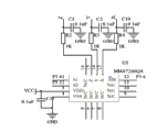
系统采用美国Freescale最新推出的一款低成本单芯片MMA7260三轴加速度传感器。该微型电容式加速度传感器融合了信号调理、单级低通滤波器和温度补偿技术,并提供四种加速度测量范围(-1.5g—+1.5g、-2.0g—+2.0g、-4.0g—+4.0g、-6.0g—+6.0g)。MMA7260还有很高的灵敏度,当选择-1.5g—+1.5g的测量范围时,灵敏度达到800mv/g。它采用6mm x 6mm x 1.45mm QFN的封装,体积小。同时MMA7260提供休眠模式,是电池充电的手持设备产品的理想之选。它具有三轴向检测功能,在便携式设备能够智能的回应方向、位置、移动的变化。可使本设备具有摇动切换屏幕显示能还能检测人体姿态,人倒自动报警的功能,使本定位仪在营救方面更加有效。 The system uses a low-cost single-chip MMA7260 three-axis acceleration sensor newly launched by Freescale in the United States. The miniature capacitive acceleration sensor combines signal conditioning, single-stage low-pass filter and temperature compensation technology, and provides four acceleration measurement ranges (-1.5g—+1.5g, -2.0g—+2.0g, -4.0g— +4.0g, -6.0g—+6.0g). MMA7260 also has high sensitivity. When the measurement range of -1.5g—+1.5g is selected, the sensitivity reaches 800mv/g. It comes in a 6mm x 6mm x 1.45mm QFN package with a small footprint. At the same time, the MMA7260 provides a sleep mode, which is an ideal choice for battery-charging handheld devices. It has a three-axis detection function, and can intelligently respond to changes in direction, position, and movement in portable devices. The device can be shaken to switch the screen display, and can also detect human body posture, and the function of automatic alarm when people fall down, so that the locator is more effective in rescue. the
Claims (5)
Priority Applications (1)
| Application Number | Priority Date | Filing Date | Title |
|---|---|---|---|
| CN2010205798195U CN201837726U (en) | 2010-10-28 | 2010-10-28 | Locator capable of networking with low power consumption based on single-chip microcomputer (SCM) |
Applications Claiming Priority (1)
| Application Number | Priority Date | Filing Date | Title |
|---|---|---|---|
| CN2010205798195U CN201837726U (en) | 2010-10-28 | 2010-10-28 | Locator capable of networking with low power consumption based on single-chip microcomputer (SCM) |
Publications (1)
| Publication Number | Publication Date |
|---|---|
| CN201837726U true CN201837726U (en) | 2011-05-18 |
Family
ID=44007833
Family Applications (1)
| Application Number | Title | Priority Date | Filing Date |
|---|---|---|---|
| CN2010205798195U Expired - Fee Related CN201837726U (en) | 2010-10-28 | 2010-10-28 | Locator capable of networking with low power consumption based on single-chip microcomputer (SCM) |
Country Status (1)
| Country | Link |
|---|---|
| CN (1) | CN201837726U (en) |
Cited By (2)
| Publication number | Priority date | Publication date | Assignee | Title |
|---|---|---|---|---|
| CN104406595A (en) * | 2014-11-27 | 2015-03-11 | 哈尔滨金都太阳能科技有限公司 | Integrated information sub-display for automatic position tracker |
| CN109962984A (en) * | 2019-03-31 | 2019-07-02 | 联想(北京)有限公司 | A kind of control method and electronic equipment |
-
2010
- 2010-10-28 CN CN2010205798195U patent/CN201837726U/en not_active Expired - Fee Related
Cited By (2)
| Publication number | Priority date | Publication date | Assignee | Title |
|---|---|---|---|---|
| CN104406595A (en) * | 2014-11-27 | 2015-03-11 | 哈尔滨金都太阳能科技有限公司 | Integrated information sub-display for automatic position tracker |
| CN109962984A (en) * | 2019-03-31 | 2019-07-02 | 联想(北京)有限公司 | A kind of control method and electronic equipment |
Similar Documents
| Publication | Publication Date | Title |
|---|---|---|
| CN103914952B (en) | Mountain torrent geological disasters monitoring devices based on thing networking | |
| WO2013182147A1 (en) | Mobile terminal and method for obtaining location information about mobile terminal | |
| CN208638381U (en) | A signal detection terminal and system based on NB-IoT | |
| CN103327450B (en) | Centralized calculation GPS receiver and localization method thereof based on mobile communications network | |
| CN101986765A (en) | Singlechip-based low-power consumption networking positioning instrument | |
| CN104764480B (en) | Method and device for judging movement from indoor to outdoor | |
| CN103903390A (en) | Locatable wearing type tumbling monitoring system | |
| CN104181615B (en) | A kind of microclimate environment and physical message monitor general-purpose platform in real time | |
| CN201837726U (en) | Locator capable of networking with low power consumption based on single-chip microcomputer (SCM) | |
| CN102866411A (en) | Geological survey safety system | |
| CN203349840U (en) | Multifunctional pedometer | |
| CN103453981A (en) | Vibration sensor node module with positioning function | |
| CN207396746U (en) | A kind of high-precision vehicle carried pick device and system based on lora transmission | |
| CN103453982A (en) | Sound sensor node module with positioning function | |
| CN201707061U (en) | Short message telemetering multiparameter recorder | |
| CN212624333U (en) | Location bracelet and location bracelet system | |
| CN116319913A (en) | Online automatic monitoring system and method for carbon dioxide gas concentration | |
| CN202582736U (en) | Human pyroelectric sensor node module with positioning function | |
| CN206945729U (en) | A kind of flow velocity instrument apparatus | |
| CN221802772U (en) | Transmission tower monitoring system | |
| CN204085526U (en) | A kind of digital electronic compass | |
| Yang et al. | A coal mine environmental monitor system with localization function based on ZigBee-compliant platform | |
| CN202582720U (en) | Node mould of sound sensor with positioning function | |
| CN217386155U (en) | smart watch | |
| Cui et al. | The design of localization in wireless sensor network node based on JENNIC platform |
Legal Events
| Date | Code | Title | Description |
|---|---|---|---|
| C14 | Grant of patent or utility model | ||
| GR01 | Patent grant | ||
| C17 | Cessation of patent right | ||
| CF01 | Termination of patent right due to non-payment of annual fee |
Granted publication date: 20110518 Termination date: 20121028 |