CN114924224B - High-precision positioning method in tunnel based on multi-frequency carrier phase - Google Patents
High-precision positioning method in tunnel based on multi-frequency carrier phase Download PDFInfo
- Publication number
- CN114924224B CN114924224B CN202210537722.5A CN202210537722A CN114924224B CN 114924224 B CN114924224 B CN 114924224B CN 202210537722 A CN202210537722 A CN 202210537722A CN 114924224 B CN114924224 B CN 114924224B
- Authority
- CN
- China
- Prior art keywords
- positioning
- frequency
- rfid
- tunnel
- solution
- Prior art date
- Legal status (The legal status is an assumption and is not a legal conclusion. Google has not performed a legal analysis and makes no representation as to the accuracy of the status listed.)
- Active
Links
Images


Classifications
-
- G—PHYSICS
- G01—MEASURING; TESTING
- G01S—RADIO DIRECTION-FINDING; RADIO NAVIGATION; DETERMINING DISTANCE OR VELOCITY BY USE OF RADIO WAVES; LOCATING OR PRESENCE-DETECTING BY USE OF THE REFLECTION OR RERADIATION OF RADIO WAVES; ANALOGOUS ARRANGEMENTS USING OTHER WAVES
- G01S5/00—Position-fixing by co-ordinating two or more direction or position line determinations; Position-fixing by co-ordinating two or more distance determinations
- G01S5/02—Position-fixing by co-ordinating two or more direction or position line determinations; Position-fixing by co-ordinating two or more distance determinations using radio waves
- G01S5/0252—Radio frequency fingerprinting
Abstract
The invention discloses a high-precision positioning method in a tunnel based on multi-frequency carrier phases, which comprises the following steps: (1) building an RFID positioning system; (2) Simulating an ultrahigh frequency RFID multipath channel model in a limited space; (3) Performing spatial filtering anti-interference processing by using the RFID positioning system built in the step (1), and performing simulation by using the multipath channel model simulated in the step (2) when performing the spatial filtering anti-interference processing; (4) After the spatial filtering anti-interference processing is completed, ranging and positioning based on a WMMSENS method are carried out, the coordinates to be positioned are solved by using a least square method, and dense multipath interference is resisted by adopting a tag array spatial filtering method; the weighted least mean square error carrier phase ranging method based on the adjacent solution search is provided for solving the problem of phase ambiguity; and finally, solving the positioning coordinates by using a least square method, so that high-precision positioning in the tunnel can be realized.
Description
Technical Field
The invention relates to the technical field of positioning of complex underground spaces such as tunnels, galleries and the like, in particular to a high-precision positioning method in a tunnel based on multi-frequency carrier phases.
Background
The high-precision target positioning is an important research content of personnel safety and disaster relief and rescue in complex underground environments such as tunnels, galleries and the like, and is also a key technology for realizing machine cooperative work and high-efficiency unmanned intelligent production in the future.
In the aspect of tunnel/roadway positioning technology, a positioning system mainly adopts a passive RFID technology. The prior RFID positioning equipment mainly depends on a received signal strength value (RSSI), is mainly divided into an RSSI positioning algorithm based on a model and a fingerprint, has low positioning complexity based on the model and simple system structure, is greatly influenced by multipath, and has generally lower precision; the RSSI positioning algorithm based on the fingerprint needs to establish a fingerprint library of signal intensity and label position, then compares the actually acquired signal intensity with the fingerprint library, and accurately estimates the target position according to a matching criterion, but under the tunnel/roadway driving environment, the fingerprint is enabled to fail faster along with the continuous change of the working space.
In recent years, with the improvement of hardware level, many RFID devices are currently capable of providing phase information, and a high-precision positioning method for acquiring distance information by using the phase information is more and more popular to students, but there is a contradiction between the ranging precision and the maximum non-ambiguous distance. Solving the whole-cycle ambiguity based on a targeting method and solving the phase ambiguity problem by using an Extended Kalman Filter (EKF) and a Rauch-Tung-Striebel (RTS) smoother, wherein the two algorithms only consider the distance information acquisition under the single frequency condition, and avoid the problem that positioning errors cannot be accumulated when solving the phase ambiguity; the method comprises the steps of fitting an ideal phase difference Euclidean distance and an actual distance between reference tags by using position information of the reference tags, so as to realize distance estimation between the tags, or installing a reader antenna on a mobile robot, and positioning the tags by fusing tag phase information and robot mileage information.
In a tunnel operation environment with limited space, frequent reflection and scattering of electromagnetic waves can cause problems of dense multipath and large phase error, and the existing anti-multipath interference and phase ranging algorithm is not applicable under the condition.
Disclosure of Invention
Aiming at the technical defects, the invention aims to provide a multi-frequency carrier phase-based high-precision positioning method in a tunnel, which is used for resisting dense multipath interference by adopting a tag array spatial filtering method; the weighted least mean square error carrier phase ranging method based on the adjacent solution search is provided for solving the problem of phase ambiguity; and finally, solving the positioning coordinates by using a least square method, so that high-precision positioning in the tunnel can be realized.
In order to solve the technical problems, the invention adopts the following technical scheme:
the invention provides a high-precision positioning method in a tunnel based on multi-frequency carrier phases, which comprises the following steps:
(1) Building an RFID positioning system;
(2) Simulating an ultrahigh frequency RFID multipath channel model in a limited space;
(3) Performing spatial filtering anti-interference processing by using the RFID positioning system built in the step (1), and performing simulation by using the multipath channel model simulated in the step (2) when performing the spatial filtering anti-interference processing;
(4) After the spatial filtering anti-interference processing is completed, the distance measurement and positioning based on the WMMSENS method are carried out, and the coordinates to be positioned are solved by using a least square method.
Preferably, the RFID positioning system in step (1) comprises a reader, an RFID antenna, a passive tag, a computer, which are connected to each other.
Preferably, the RFID positioning system is built in a tunnel with the width of 4.6 meters and the height of 5 meters, positioning datum points of the passive tags are distributed in a grid with the size of 0.6mx0.6m, the RFID antenna and the passive tags are kept at the same horizontal plane, and the RFID antenna comprises the following coordinates from left to right: (0, 0), (0.6, -0.1), (1.2, 0).
Preferably, step (3) uses the multipath channel model simulated in step (2) to simulate the path gain G of the deterministic multipath channel between the reader and the passive tag p The method comprises the following steps:


wherein: lambda is the wavelength; d, d 0 Is the direct path length; d, d i Is the ith reflection path length; Γ -shaped structure i The reflection coefficient of the ith reflection path; k is wave number; n is the total number of indirect paths; h is a complex factor;
the phase of the passive tag signal received by the reader is phi= -2kd 0 +2rag(H)+n 0 Wherein arg (H) is the angle of the plurality of H; n is n 0 Is errors caused by Gaussian noiseAnd (3) difference.
Preferably, the step (3) specifically includes:
(31) A reader using an RFID positioning system sequentially transmits a plurality of frequencies and records its estimated direction angle θ i ;
(32) Obtaining the median theta of each frequency direction angle M ;
(33) Obtaining the difference between each frequency direction angle and the median
(34) Obtaining the median of the differences
(35) Removing and removing ρ is an outlier threshold.
Preferably, the step (4) specifically includes:
(41) The data of the passive tags at 9 test points with the interval of 0.6m are collected sequentially by using a reader and an RFID antenna of an RFID positioning system;
(42) Filtering the data acquired in the step (41) by using a computer;
(43) After the data is subjected to filtering processing, a WMMSENS multi-frequency carrier phase ranging algorithm is utilized to perform ranging processing; the method specifically comprises the following steps:
(43a) For different noise parameters of different carriers, a weighted vector W is introduced for processing, and the mean square error is expressed as:


(43b) Setting the frequencyf i The true phase value of (2) is phi i Error is variance sigma i Gaussian noise n of (1) i Frequency f i The distance estimate of (2) is:

the weighted distance estimate is:

(43c) The weighting vector W is solved using the following formula:


will be described in Carry-in +.>
 Obtaining:


noise at each frequency is independent of each other, namely:


setting:

A=[1,1,...,1] 1*K
using lagrangian multiplication division:

wherein W is * For the optimal weighting vector; μ is a lagrange multiplier vector;
(43d) According to the solving weighting vector W, solving the solution of the fuzzy number vector by introducing a method of adjacent solution searching and discrete point removing, and setting the current fuzzy number vector as n= [ n ] 1 ,n 2 ,...,n K ]If there is a fuzzy number vector n '= [ n ]' 1 ,n′ 2 ,...,n′ K ]Satisfy |n '' i -n i I.ltoreq.1 (i=1, 2,..k), then n' is said to be the adjacent solution to n, and when the full-period solution at the previous time is known, the adjacent solution is directly searched to solve the current solution, and the specific steps are as follows:
(43d1) Solving a previous full period solution n and all adjacent solutions n 'thereof according to the estimated distance of the previous moment' j Is a weighted mean square error of (2)
(43d2) For a pair of Sorting, namely finding out the solution with the minimum mean square error as the current optimal solution +.>
(43d3) Solving the estimated distance d of each frequency i Estimating distance from current optimal solution Difference of->
(43d4) Find the median of the differences And remove->
 The above discrete frequency data;
(43d5) Repeating steps (43 d 1), (43 d 2) using the frequency data from which the discrete data has been removed;
(43d6) Performing the next iteration;
(44) Let the antenna coordinates be fixed coordinates (x 1 ,y 1 ),(x 2 ,y 2 ),…,(x n ,y n ) The method comprises the steps of carrying out a first treatment on the surface of the The coordinates of the label to be positioned are (x, y); measuring the distance d between the antenna and the positioning tag according to the steps (41) - (43) 1 ,d 2 ,…,d n Obtaining an equation set:

the first term minus the second term, the second term minus the third term, and so on, are represented in matrix form:
AX=B
wherein:
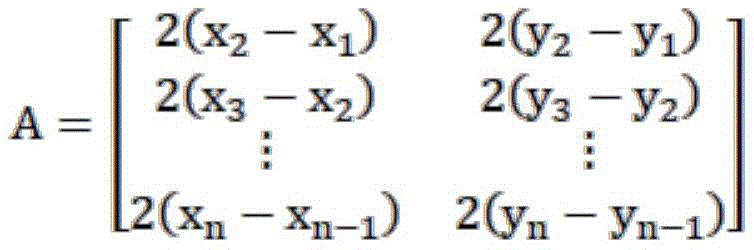


the least squares method is used to minimize the sum of squares of the solutions, namely:
E(X)=(AX-B) T (AX-B)
and (3) deriving and enabling the derivative to be equal to 0, and obtaining the position coordinate X:
X=(A T A) -1 (A T B)。
the invention has the beneficial effects that:
the invention adopts a label array airspace filtering method to resist dense multipath interference; the weighted least mean square error carrier phase ranging method based on the adjacent solution search is provided for solving the problem of phase ambiguity; finally, the positioning coordinates are solved by using a least square method, and the method can realize high-precision positioning in the tunnel.
Drawings
In order to more clearly illustrate the embodiments of the invention or the technical solutions in the prior art, the drawings that are required in the embodiments or the description of the prior art will be briefly described, it being obvious that the drawings in the following description are only some embodiments of the invention, and that other drawings may be obtained according to these drawings without inventive effort for a person skilled in the art.
Fig. 1 is a schematic diagram of an experimental platform for researching a multi-frequency carrier phase-based high-precision positioning algorithm in a tunnel according to an embodiment of the invention.
Fig. 2 is a schematic diagram of a multipath channel model studied by a multi-frequency carrier phase based in-tunnel high-precision positioning algorithm according to an embodiment of the present invention.
Fig. 3 is a schematic diagram of a filtering result and a true value subtracted absolute value result based on a spatial filtering anti-interference method test in an embodiment of the present invention.
Detailed Description
The following description of the embodiments of the present invention will be made clearly and completely with reference to the accompanying drawings, in which it is apparent that the embodiments described are only some embodiments of the present invention, but not all embodiments. All other embodiments, which can be made by those skilled in the art based on the embodiments of the invention without making any inventive effort, are intended to be within the scope of the invention.
The embodiment provides a high-precision positioning method in a tunnel based on multi-frequency carrier phases, which specifically comprises the following steps:
s0: building an RFID positioning system; simulating an ultrahigh frequency RFID multipath channel model in a limited space;
s1: providing a spatial filtering algorithm based on Multi-frequency direction angle estimation (Multi-Frequency Directional Angle Estimation, MFDAE) to inhibit dense multipath interference in a tunnel;
s2: a weighted minimum mean square error (Weighted Minimum Mean Square Error based on Near solution Search, WMMSENS) multi-frequency carrier phase ranging method based on adjacent solution search is provided, and the problem of phase ambiguity is solved;
s3: and (5) realizing the calculation of the target position in the tunnel by a least square method.
In step S1, the proposed concept and steps of a spatial filtering algorithm based on multifrequency direction angle estimation are as follows:
the communication in the tunnel has Gaussian noise and dense multipath effect, so an MFDAE spatial filtering algorithm is proposed, and the algorithm is specifically implemented as follows:
the filtering weight vector is required to know the incident direction of the signal on one hand, and the signal autocorrelation matrix is required to be reversible on the other hand, and for the carrier signal, the reversibility cannot be ensured by directly obtaining the autocorrelation matrix.
Assuming that the input signal has only multipath interference and no gaussian noise, a linear array input signal can be obtained:

proposing carrier e jωt Obtaining:

the first two terms are multiplied and expressed in exponential form:

is provided with Its autocorrelation function is:

is provided with Then for all of the above formulas i=2, 3,..n, there is:
T 1,i [r 1,1 ,r 1,2 ,...,r 1,N ]=[r i,1 ,r i,2 ,...,r i,N ]
the rank of R is therefore 1, which is irreversible; if the weight vector W is required, rank increasing is required for R; the following gives an ascending rank method based on subarray correlation matrix averaging:
firstly, taking the situation of averaging of two subarrays, and obtaining the average of autocorrelation matrixes of 1-N-1 label signals and 2-N label signals:

let k be i Is that The i-th row vector is then for->
 And (3) performing elementary transformation to obtain:


it can be seen that Rank of 2. Similarly, if an m×m full rank autocorrelation matrix is to be obtained, an average value of M m×m subarrays may be taken, and the filtering weight may be obtained when the matrix is full rank.
Under the condition that an angle estimation error possibly occurs when the direction angle estimation is performed, the phase of a signal filtered by a weighted vector based on the error direction angle also has a larger error, and an MFDAE spatial filtering algorithm is provided for solving the problem, and the specific implementation steps of the algorithm are as follows:
s11, the reader sequentially transmits a plurality of frequencies to respectively carry out the above spatial filtering processing method and records the estimated direction angle theta i ;
S12, obtaining the median theta of each frequency direction angle M ;
S13, obtaining the difference value between each frequency direction angle and the median />
/>
S14, obtaining the median of the difference
S15, rejecting ρ is an outlier threshold.
The carrier frequency adopted by the ultrahigh frequency RFID is between 860MHz and 960MHz, the wavelength of the carrier frequency is 31-35 cm, and in the positioning process in a tunnel, the positioning target most exceeds the range, so that the problem of integer period ambiguity can be generated, and in practice, the following three problems are generally encountered when a direct integer period ambiguity solving algorithm is used for ranging: 1. the noise parameters of the measured phases will be different due to the different carrier frequencies; 2. due to the influence of noise, the complexity of the optimal integer period fuzzy number algorithm is high, and the solving difficulty is high; 3. the probability of solving errors is high due to the existence of large phase errors.
In step S2, a weighted minimum mean square error multi-frequency carrier phase ranging method based on neighbor solution search is proposed:
specifically, the WMMSENS multi-frequency carrier phase ranging algorithm comprises the following steps:
for the problem of different noise parameters of different carriers, a weighting vector W is introduced, and the mean square error is expressed as:


the calculation algorithm of the weighting vector W is given, and the frequency f is set i The true phase value of (2) is phi i Error is variance sigma i Gaussian noise n of (1) i Frequency f i The distance estimate of (2) is:

the weighted distance estimate is:

selecting W requires minimizing the estimated distance error, i.e., W is a solution to the problem:


will be described in Carry-in +.>
 Obtaining the product


Noise at each frequency is independent of each other, namely:


setting:

A=[1,1,...,1] 1*K
using lagrangian multiplication division:

wherein W is * For the optimal weighting vector; μ is the lagrange multiplier vector.
Aiming at the problems of higher complexity and large phase error of the traditional algorithm, a method for searching adjacent solutions and removing discrete points is introduced, and the current fuzzy number vector is set as n= [ n ] 1 ,n 2 ,...,n K ]If there is a fuzzy number vector n '=n' 1 ,n′ 2 ,...,n′ K ]Satisfy |n '' i -n i I.ltoreq.1 (i=1, 2,..k), then n' is said to be the adjacent solution to n; in the actual positioning process, the label coordinates are not completely random, and the common offset of the coordinates at the current moment and the coordinates at the previous moment is smaller, so that when the whole period solution at the previous moment is known, the adjacent solution is directly searched to solve the current solution; the specific method comprises the following steps:
s21: solving a previous full period solution n and all adjacent solutions n 'thereof according to the estimated distance of the previous moment' j Is a weighted mean square error of (2)
S22: for a pair of Sorting, namely finding out the solution with the minimum mean square error as the current optimal solution +.>
S23: solving the estimated distance d of each frequency i Estimating distance from current optimal solution Difference of->
S24: find the median of the differences And remove->
 The above discrete frequency data;
s25: repeating the steps S21, S22 by using the frequency data from which the discrete data have been removed;
s26: the next iteration is performed.
In step S3, the target position in the tunnel is resolved by the least square method, and the positioning algorithm based on the least square method is as follows:
let the antenna coordinates be fixed coordinates (x 1 ,y 1 ),(x 2 ,y 2 ),…,(x n ,y n ) The method comprises the steps of carrying out a first treatment on the surface of the The coordinates of the tag to be located are (x, y). The distance between the antenna and the positioning tag is measured as d according to the method 1 ,d 2 ,…,d n The method comprises the steps of carrying out a first treatment on the surface of the To sum up, the equation set can be obtained:

the first term minus the second term, the second term minus the third term, and so on, and then expressed as a matrix:
AX=B
wherein:


the least square method is the least sum of squares solution error, i.e.:
E(X)=(AX-B) T (AX-B)
and (3) solving X and enabling E to be the smallest, and then:
X(A T ) -1 (A T B)
to sum up, the specific flow of the positioning method of this embodiment is:


as shown in fig. 1 to 2, the embodiment builds an RFID positioning system, where the RFID positioning system includes an Impinj R2000 reader module, an RFID antenna, a passive tag, and a computer that are connected to each other, and the positioning system is disposed in a tunnel with a width of 4.6 meters and a height of 5 meters.
In the positioning scene, the positioning datum points of the passive tags are distributed in a standard 0.6mx0.6m size grid, and the RFID antenna and the passive tags keep the same horizontal plane. The RFID antenna coordinates are respectively from left to right: (0,0), (0.6, -0.1), (1.2,0). When ranging and positioning are carried out, firstly, moving the passive tag to a corresponding test point, using a computer to send a phase acquisition instruction to a reader module to acquire a phase, keeping the tag in a static state, and sequentially frequency-modulating and sending 865-925Mhz frequency-modulated signals by the reader, wherein the frequency-hopping interval is 10MHz.
In order to conveniently show the performance of the anti-interference method, the simulation is carried out by adopting the channel response model shown in fig. 2, the label coordinates are obtained by uniformly distributing in a 3X3m space to obtain an initial point, then the initial point is slowly changed by Gaussian distribution with a variance of 0.01, sampling is carried out 100 times, the reader-writer coordinates are (0, 2), the multipath number is 6, the multipath reflection coefficient is 0.3, the incident angle is sampled by uniform random distribution, the SNR is 5, the reflection coefficient is 0.3, the frequency is (850,860,870,880,890,900,910,920) MHz, the discrete threshold is 2, and the absolute value result is obtained by subtracting the filtering result from the true value as shown in fig. 3 for conveniently observing the performance of the algorithm.
In the environment of fig. 1, firstly, using a reader and an RFID antenna to collect data at 9 test points shown in fig. 1 in sequence, then using a computer to filter the collected data, and then carrying out centralized processing according to the method of the embodiment to solve the coordinates to be positioned.
In the embodiment, the measured phase error mean value reaches 1.5 degrees by using the MFDAE spatial filtering anti-interference method, and is always kept below 5 degrees.
The positioning error between the positioning data measured by the method of the embodiment and the actual test point is smaller, and the positioning method of the embodiment is not affected by the distance and has stronger robustness.
It will be apparent to those skilled in the art that various modifications and variations can be made to the present invention without departing from the spirit or scope of the invention. Thus, it is intended that the present invention also include such modifications and alterations insofar as they come within the scope of the appended claims or the equivalents thereof.
Claims (6)
1. The method for positioning the tunnel with high precision based on the multi-frequency carrier phase is characterized by comprising the following steps:
(1) Building an RFID positioning system;
(2) Simulating an ultrahigh frequency RFID multipath channel model in a limited space;
(3) Performing spatial filtering anti-interference processing by using the RFID positioning system built in the step (1), and performing simulation by using the multipath channel model simulated in the step (2) when performing the spatial filtering anti-interference processing;
(4) After the spatial filtering anti-interference processing is completed, the distance measurement and positioning based on the WMMSENS method are carried out, and the coordinates to be positioned are solved by using a least square method.
2. The method of high-precision positioning in a tunnel based on multi-frequency carrier phase according to claim 1, wherein the RFID positioning system in step (1) comprises a reader, an RFID antenna, a passive tag, and a computer connected to each other.
3. The method for positioning in a tunnel with high precision based on multi-frequency carrier phases according to claim 2, wherein the RFID positioning system is built in a tunnel with a width of 4.6 meters and a height of 5 meters, positioning reference points of the passive tags are distributed in a grid with a size of 0.6m x0.6m, the RFID antenna and the passive tags are kept at the same horizontal plane, and the coordinates of the RFID antenna are respectively as follows from left to right: (0, 0), (0.6, -0.1), (1.2, 0).
4. The method of high-precision positioning in a tunnel based on multi-frequency carrier phase as claimed in claim 2, wherein the step (3) uses the multipath channel model simulated in the step (2) to simulate the path gain G of the deterministic multipath channel between the reader and the passive tag p The method comprises the following steps:


wherein: lambda is the wavelength; d, d 0 Is the direct path length; d, d i Is the ith reflection path length; Γ -shaped structure i The reflection coefficient of the ith reflection path; k is wave number; n is the total number of indirect paths; h is a complex factor;
the phase of the passive tag signal received by the reader is phi= -2kd 0 +2arg(H)+n 0 Wherein arg (H) is the angle of the plurality of H; n is n 0 Is an error caused by gaussian noise.
5. The method for positioning in a tunnel with high precision based on multi-frequency carrier phase as claimed in claim 1, wherein the step (3) specifically comprises:
(31) A reader using an RFID positioning system sequentially transmits a plurality of frequencies and records its estimated direction angle θ i ;
(32) Obtaining the median theta of each frequency direction angle M ;
(33) Obtaining the difference between each frequency direction angle and the median
(34) Obtaining the median of the differences
(35) Removing and removing ρ is an outlier threshold.
6. The method for positioning in a tunnel with high precision based on multi-frequency carrier phase as claimed in claim 1, wherein the step (4) specifically comprises:
(41) During experiments, the data of the passive tags of 9 test points with the interval of 0.6m are sequentially collected by using a reader and an RFID antenna of an RFID positioning system;
(42) Filtering the data acquired in the step (41) by using a computer;
(43) After the data is subjected to filtering processing, a WMMSENS multi-frequency carrier phase ranging algorithm is utilized to perform ranging processing; the method specifically comprises the following steps:
(43a) For different noise parameters of different carriers, a weighted vector W is introduced for processing, and the mean square error is expressed as:


(43b) Setting frequency f i The true phase value of (2) is phi i Error is variance sigma i Gaussian noise n of (1) i Frequency f i The distance estimate of (2) is:

the weighted distance estimate is:

(43c) The weighting vector W is solved using the following formula:


will be described in Carry-in +.>
 Obtaining:


noise at each frequency is independent of each other, namely:


setting:

A=[1,1,...,1] 1*K
using lagrangian multiplication division:

wherein W is * For the optimal weighting vector; μ is a lagrange multiplier vector;
(43d) According to the solving weighting vector W, solving the solution of the fuzzy number vector by introducing a method of adjacent solution searching and discrete point removing, and setting the current fuzzy number vector as n= [ n ] 1 ,n 2 ,...,n K ]If there is a fuzzy number vector n '= [ n ]' 1 ,n′ 2 ,...,n′ K ]Satisfy |n '' i -n i I is less than or equal to 1 (i=1, 2,..k), then n 'is called n' as the adjacent solution, and when the whole period solution of the previous moment is known, the adjacent solution is directly searched to solve the current solution, and the specific steps are as follows:
(43d1) Solving a previous full period solution n and all adjacent solutions n 'thereof according to the estimated distance of the previous moment' j Is a weighted mean square error of (2)
(43d2) For a pair of Sorting, namely finding out the solution with the minimum mean square error as the current optimal solution +.>
(43d3) Solving the estimated distance d of each frequency i Estimating distance from current optimal solution Difference of->
(43d4) Find the median of the differences And remove->
 The above discrete frequency data;
(43d5) Repeating steps (43 d 1), (43 d 2) using the frequency data from which the discrete data has been removed;
(43d6) Performing the next iteration;
(44) Let the antenna coordinates be fixed coordinates (x 1 ,y 1 ),(x 2 ,y 2 ),…,(x n ,y n ) The method comprises the steps of carrying out a first treatment on the surface of the The coordinates of the label to be positioned are (x, y); measuring the distance d between the antenna and the positioning tag according to the steps (41) - (43) 1 ,d 2 ,…,d n Obtaining an equation set:

the first term minus the second term, the second term minus the third term, and so on, are represented in matrix form:
AX=B
wherein:


the least squares method is used to minimize the sum of squares of the solutions, namely:
E(X)=(AX-B) T (AX-B)
and (3) deriving and enabling the derivative to be equal to 0, and obtaining the position coordinate X:
X=(A T A) -1 (A T B)。
Priority Applications (1)
| Application Number | Priority Date | Filing Date | Title |
|---|---|---|---|
| CN202210537722.5A CN114924224B (en) | 2022-05-17 | 2022-05-17 | High-precision positioning method in tunnel based on multi-frequency carrier phase |
Applications Claiming Priority (1)
| Application Number | Priority Date | Filing Date | Title |
|---|---|---|---|
| CN202210537722.5A CN114924224B (en) | 2022-05-17 | 2022-05-17 | High-precision positioning method in tunnel based on multi-frequency carrier phase |
Publications (2)
| Publication Number | Publication Date |
|---|---|
| CN114924224A CN114924224A (en) | 2022-08-19 |
| CN114924224B true CN114924224B (en) | 2023-05-02 |
Family
ID=82809621
Family Applications (1)
| Application Number | Title | Priority Date | Filing Date |
|---|---|---|---|
| CN202210537722.5A Active CN114924224B (en) | 2022-05-17 | 2022-05-17 | High-precision positioning method in tunnel based on multi-frequency carrier phase |
Country Status (1)
| Country | Link |
|---|---|
| CN (1) | CN114924224B (en) |
Families Citing this family (1)
| Publication number | Priority date | Publication date | Assignee | Title |
|---|---|---|---|---|
| CN116299173B (en) * | 2023-01-06 | 2023-09-29 | 中铁武汉电气化局集团有限公司 | Tunnel positioning method and system based on laser ranging and RFID technology |
Citations (2)
| Publication number | Priority date | Publication date | Assignee | Title |
|---|---|---|---|---|
| CN111948602A (en) * | 2020-08-17 | 2020-11-17 | 南京工程学院 | Two-dimensional UWB indoor positioning method based on improved Taylor series |
| CN112101051A (en) * | 2020-09-05 | 2020-12-18 | 西安电子科技大学 | Vehicle positioning method and system based on ultrahigh frequency RFID |
Family Cites Families (5)
| Publication number | Priority date | Publication date | Assignee | Title |
|---|---|---|---|---|
| US8188908B2 (en) * | 2010-01-29 | 2012-05-29 | Amtech Systems, LLC | System and method for measurement of distance to a tag by a modulated backscatter RFID reader |
| CN102213755B (en) * | 2011-04-02 | 2012-10-31 | 中国矿业大学(北京) | Ultra wide band location method and system in coal mine well |
| CN105242241A (en) * | 2015-10-28 | 2016-01-13 | 国家电网公司 | Indoor positioning method based on Wi-Fi |
| US10337835B2 (en) * | 2016-05-11 | 2019-07-02 | Rivada Research LLC | Method and system for using enhanced location-based information to guide munitions |
| CN111208500A (en) * | 2019-05-30 | 2020-05-29 | 中国矿业大学 | Development machine pose parameter detection method based on passive RFID |
-
2022
- 2022-05-17 CN CN202210537722.5A patent/CN114924224B/en active Active
Patent Citations (2)
| Publication number | Priority date | Publication date | Assignee | Title |
|---|---|---|---|---|
| CN111948602A (en) * | 2020-08-17 | 2020-11-17 | 南京工程学院 | Two-dimensional UWB indoor positioning method based on improved Taylor series |
| CN112101051A (en) * | 2020-09-05 | 2020-12-18 | 西安电子科技大学 | Vehicle positioning method and system based on ultrahigh frequency RFID |
Also Published As
| Publication number | Publication date |
|---|---|
| CN114924224A (en) | 2022-08-19 |
Similar Documents
| Publication | Publication Date | Title |
|---|---|---|
| Chai et al. | Reference tag supported RFID tracking using robust support vector regression and Kalman filter | |
| Karanam et al. | Tracking from one side: Multi-person passive tracking with WiFi magnitude measurements | |
| Niitsoo et al. | Convolutional neural networks for position estimation in tdoa-based locating systems | |
| He et al. | Tilejunction: Mitigating signal noise for fingerprint-based indoor localization | |
| CN105676171B (en) | Single channel Dual base stations ultrashort wave signals space-location method | |
| CN104519571B (en) | A kind of indoor orientation method based on RSS | |
| CN107102292B (en) | A kind of target bearing tracking based on bayes method | |
| CN105549005A (en) | Dynamic target direction of arrive tracking method based on mesh dividing | |
| CN103945531B (en) | Method for WLAN indoor positioning Radio Map updating based on information entropy | |
| Peng et al. | Deep convolutional neural network for passive RFID tag localization via joint RSSI and PDOA fingerprint features | |
| CN114924224B (en) | High-precision positioning method in tunnel based on multi-frequency carrier phase | |
| Djosic et al. | Multi-algorithm UWB-based localization method for mixed LOS/NLOS environments | |
| CN108459296A (en) | A kind of nested array Wave arrival direction estimating methods based on management loading out of place | |
| Aomumpai et al. | Optimal placement of reference nodes for wireless indoor positioning systems | |
| Vashist et al. | Indoor wireless localization using consumer-grade 60 GHz equipment with machine learning for intelligent material handling | |
| Ledergerber et al. | Angle of arrival estimation based on channel impulse response measurements | |
| CN107656239B (en) | Coherent information source direction finding method based on polarization sensitive array | |
| CN107037423A (en) | Multi-object tracking method is filtered with reference to the PHD of amplitude information | |
| US20170082722A1 (en) | Kalman filtered correlation intefereomtry geolocation | |
| Song et al. | Fingerprinting localization method based on toa and particle filtering for mines | |
| Koledoye et al. | Improved MDS-based localization with non-line-of-sight RF links | |
| Henninger et al. | A computationally efficient 2D MUSIC approach for 5G and 6G sensing networks | |
| Borenović et al. | Space partitioning strategies for indoor WLAN positioning with cascade-connected ANN structures | |
| Farnham | Indoor localisation of iot devices by dynamic radio environment mapping | |
| CN107341424B (en) | A kind of precise phase calculation method based on the estimation of RFID multipath |
Legal Events
| Date | Code | Title | Description |
|---|---|---|---|
| PB01 | Publication | ||
| PB01 | Publication | ||
| SE01 | Entry into force of request for substantive examination | ||
| SE01 | Entry into force of request for substantive examination | ||
| GR01 | Patent grant | ||
| GR01 | Patent grant |