CN113236249A - Self-adaptive cutting method for fusing geological baselines - Google Patents
Self-adaptive cutting method for fusing geological baselines Download PDFInfo
- Publication number
- CN113236249A CN113236249A CN202110114128.0A CN202110114128A CN113236249A CN 113236249 A CN113236249 A CN 113236249A CN 202110114128 A CN202110114128 A CN 202110114128A CN 113236249 A CN113236249 A CN 113236249A
- Authority
- CN
- China
- Prior art keywords
- coal
- geological
- cutting
- coal seam
- analysis
- Prior art date
- Legal status (The legal status is an assumption and is not a legal conclusion. Google has not performed a legal analysis and makes no representation as to the accuracy of the status listed.)
- Granted
Links
- 238000005520 cutting process Methods 0.000 title claims abstract description 81
- 238000000034 method Methods 0.000 title claims abstract description 41
- 239000003245 coal Substances 0.000 claims abstract description 193
- 238000005065 mining Methods 0.000 claims abstract description 84
- 238000005259 measurement Methods 0.000 claims abstract description 27
- 238000004458 analytical method Methods 0.000 claims description 28
- 230000008569 process Effects 0.000 claims description 17
- 238000007619 statistical method Methods 0.000 claims description 6
- 230000000694 effects Effects 0.000 claims description 5
- 238000004422 calculation algorithm Methods 0.000 claims description 3
- 238000011161 development Methods 0.000 claims description 3
- 238000011156 evaluation Methods 0.000 claims description 3
- 230000007246 mechanism Effects 0.000 claims description 3
- 238000011160 research Methods 0.000 claims description 3
- 230000002441 reversible effect Effects 0.000 claims description 2
- 230000003044 adaptive effect Effects 0.000 claims 6
- 230000008859 change Effects 0.000 description 22
- 238000005516 engineering process Methods 0.000 description 6
- 230000002159 abnormal effect Effects 0.000 description 5
- 238000004891 communication Methods 0.000 description 5
- 238000004364 calculation method Methods 0.000 description 4
- 238000005553 drilling Methods 0.000 description 4
- 238000003384 imaging method Methods 0.000 description 3
- 230000009467 reduction Effects 0.000 description 3
- 238000009991 scouring Methods 0.000 description 3
- 101000957437 Homo sapiens Mitochondrial carnitine/acylcarnitine carrier protein Proteins 0.000 description 2
- 102100038738 Mitochondrial carnitine/acylcarnitine carrier protein Human genes 0.000 description 2
- 230000009471 action Effects 0.000 description 2
- 239000003086 colorant Substances 0.000 description 2
- 230000000977 initiatory effect Effects 0.000 description 2
- 239000011435 rock Substances 0.000 description 2
- 238000005211 surface analysis Methods 0.000 description 2
- 230000008719 thickening Effects 0.000 description 2
- 230000005641 tunneling Effects 0.000 description 2
- 230000005856 abnormality Effects 0.000 description 1
- 238000012790 confirmation Methods 0.000 description 1
- 238000012937 correction Methods 0.000 description 1
- 238000013499 data model Methods 0.000 description 1
- 230000003247 decreasing effect Effects 0.000 description 1
- 230000007547 defect Effects 0.000 description 1
- 238000013461 design Methods 0.000 description 1
- 238000001514 detection method Methods 0.000 description 1
- 238000010586 diagram Methods 0.000 description 1
- 238000000605 extraction Methods 0.000 description 1
- 238000011010 flushing procedure Methods 0.000 description 1
- 238000000265 homogenisation Methods 0.000 description 1
- 238000007781 pre-processing Methods 0.000 description 1
- 238000012545 processing Methods 0.000 description 1
- 238000004904 shortening Methods 0.000 description 1
- 230000003068 static effect Effects 0.000 description 1
- 230000009466 transformation Effects 0.000 description 1
Images


Classifications
-
- E—FIXED CONSTRUCTIONS
- E21—EARTH OR ROCK DRILLING; MINING
- E21C—MINING OR QUARRYING
- E21C41/00—Methods of underground or surface mining; Layouts therefor
- E21C41/16—Methods of underground mining; Layouts therefor
- E21C41/18—Methods of underground mining; Layouts therefor for brown or hard coal
-
- E—FIXED CONSTRUCTIONS
- E21—EARTH OR ROCK DRILLING; MINING
- E21C—MINING OR QUARRYING
- E21C35/00—Details of, or accessories for, machines for slitting or completely freeing the mineral from the seam, not provided for in groups E21C25/00 - E21C33/00, E21C37/00 or E21C39/00
- E21C35/24—Remote control specially adapted for machines for slitting or completely freeing the mineral
Landscapes
- Engineering & Computer Science (AREA)
- Mining & Mineral Resources (AREA)
- Life Sciences & Earth Sciences (AREA)
- General Life Sciences & Earth Sciences (AREA)
- Geochemistry & Mineralogy (AREA)
- Geology (AREA)
- Mechanical Engineering (AREA)
- Remote Sensing (AREA)
- Excavating Of Shafts Or Tunnels (AREA)
- Management, Administration, Business Operations System, And Electronic Commerce (AREA)
Abstract
The invention discloses a self-adaptive cutting method fusing geological baselines, which fuses and analyzes geological data and measurement data, constructs a multi-attribute comprehensive mining working face geological baseline model, performs grid division on a coal bed digital model in the trend and the inclination of a working face, and performs coal bed digital model cutting according to a coal mining plan.
Description
Technical Field
The invention belongs to the field of input cutting methods, and particularly relates to a self-adaptive cutting method fusing geological baselines.
Background
The prior technical scheme is a memory cutting technology of a coal mining machine, and the memory cutting technology is characterized in that the coal mining machine is manually operated to cut coal, so that passive coal cutting of the coal mining machine is realized, the action process of the coal mining machine is recorded and stored, and a control instruction is issued to the coal mining machine to realize the memory coal cutting of the coal mining machine. The prior art can obtain good application effect aiming at a mine with good working face environment, and if the application to complex geological environment still has many problems, more manual intervention is needed.
Disclosure of Invention
The invention aims to overcome the defects and provide a self-adaptive cutting method fusing geological baselines, which can carry out self-correction on mining equipment of a fully mechanized mining face according to specific conditions of different geological environments of different mines.
In order to achieve the above object, the present invention comprises the steps of:
s1, integrating and analyzing geological data and measurement data, and constructing a multi-attribute fully mechanized coal mining face geological baseline model by using an interpolation algorithm;
s2, researching the mining process, setting the step length of the model mesh, carrying out mesh division on the coal bed digital model in the trend and the trend of the working face, and projecting the mesh to a two-dimensional horizontal plane;
s3, cutting a coal seam digital model according to a coal mining plan, projecting curved surfaces of a top plate and a bottom plate of the coal seam to a two-dimensional horizontal plane respectively, calculating a plane coordinate of an intersection point of a straight line segment and a grid line and elevations of the top plate and the bottom plate corresponding to the straight line segment, and sequentially connecting obtained control points of the top plate and the bottom plate according to the direction of the straight line segment to obtain an interface curve of the top plate and the bottom plate as a cutting curve;
s4, cutting is executed according to the cutting curve, and the cutting execution effect is evaluated;
and S5, correcting the planning curve according to the evaluation of the cutting execution effect.
The geological measurement comprises roadway mark point measurement, roadway gradient measurement, bottom plate elevation, top plate elevation, coal thickness, coal bed occurrence and drilling positioning measurement.
The method comprises the steps of constructing a multi-attribute fully mechanized coal mining face geological baseline model, and performing coal seam thickness statistical analysis, coal seam thickness variation coefficient analysis, coal seam dip angle variation analysis, coal seam thickness variation trend analysis and geological abnormal body analysis.
In S3, the working face is taken as a research unit, and the development of various exploration technologies is combined to carry out comprehensive analysis on the geological condition of the working face, wherein the comprehensive analysis content comprises the following steps: the method comprises the following steps of coal seam thickness statistical analysis, coal seam thickness variation coefficient analysis, coal seam inclination angle variation analysis, coal seam thickness variation trend analysis and geological anomaly analysis.
Planning the obtained cutting curve according to the multi-attribute geological baseline model of the fully mechanized mining face, presetting the running speeds and the turning-back point positions of the coal mining machine in different process sections by combining the coal mining process of the coal mining machine, setting a speed-reducing mechanism in advance, and controlling the speed reduction and reversing of the coal mining machine at the turning-back position.
The coal mining machine operates according to the planned cutting curve, and the cutting height of the roller is adjusted in a self-adaptive mode so as to ensure that the coal mining machine is matched with the planned cutting curve; when the coal mining machine enters the other quadrant triangle coal stages to operate, the coal mining machine receives a command of the turning point position in the accurate control, and planning deceleration, shutdown and reverse action are carried out according to the turning point position.
Compared with the prior art, the method provided by the invention integrates and analyzes geological data and measurement data, constructs a multi-attribute comprehensive mining working face geological baseline model, performs grid division on a coal bed digital model in the trend and the inclination of the working face, and performs coal bed number model cutting according to a coal mining plan.
Drawings
FIG. 1 is a diagram illustrating measured data of an air intake lane, an air return lane, and a cutting hole according to an embodiment of the present invention; wherein, (a) the return airway and (b) the intake airway;
FIG. 2 is a contour plot of the thickness of a coal seam in an embodiment of the present invention;
FIG. 3 is a graph illustrating changes in dip angle of a coal seam in accordance with an embodiment of the present invention;
FIG. 4 is a graph illustrating the trend of the thickness of a coal seam for 1 time in an embodiment of the present invention;
FIG. 5 is a graph of the remaining trend of coal seam thickness 1 time in accordance with an embodiment of the present invention;
FIG. 6 is a graph illustrating the 2-time trend in coal seam thickness in an example of the present invention;
FIG. 7 is a graph of a working surface notch wave CACT imaging according to an embodiment of the present invention;
FIG. 8 is a CDM image of a reflection channel wave of a return airway of a working face according to an embodiment of the present invention;
Detailed Description
The invention is further described below with reference to the accompanying drawings.
Based on coal mine roadway fine measurement, geological data and measurement data are fused and analyzed, and a multi-attribute comprehensive mining working surface geological baseline model is constructed by utilizing an interpolation algorithm. And (3) setting the grid step length of the model by researching the mining process, carrying out grid division on the coal bed digital model in the trend and the inclination of the working face, and projecting the grid to a two-dimensional horizontal plane. And cutting a coal bed digital model according to a coal mining plan, projecting the curved surfaces of the top plate/the bottom plate of the coal bed to a two-dimensional horizontal plane respectively, calculating the plane coordinates of the intersection points of the straight line sections and the grid lines and the elevations of the top plate/the bottom plate corresponding to the straight line sections, and sequentially connecting the obtained top plate/bottom plate control points according to the direction of the straight line sections to obtain a top plate/bottom plate interface curve. In the process of tunneling, part of abnormal structures including fault, coal thickness and thinning area, crushing area and the like can be exposed. After the fully mechanized mining working face is formed, other geological information, mainly including coal thickness information and coal seam fluctuation information, is disclosed by the air inlet roadway, the air return roadway and the cutting holes. In general, the main body of the roadway section is located in a coal seam, and if the coal seam is thick, a part of top coal and bottom coal are left; if the thickness of the coal seam is relatively consistent with the design height of the roadway, the roadway top and bottom plates are basically superposed; when the coal seam is thin, the bottom or the top of the coal can be cut in the actual coal mining process. If top and bottom coal is not left in the tunneling process, the inclination angle and the inclination of the coal bed at the local position can be measured, and the fluctuation form of the coal bed is quantized.
Example (b):
the roadway exposure information is not only key hard data for establishing the fully mechanized working face static geological model, but also key reference data for developing other mine geophysical prospecting, so the roadway fine measurement work is the basis for constructing the transparent working face model.
1) Measuring instrument
According to the measurement requirement, the measuring instrument adopted at this time is a total station.
2) Measuring range and method
The roadway measurement range is the whole air intake roadway and the whole air return roadway of a certain fully mechanized mining face, and the roadway space information and the coordinate position of a drilling hole opening are measured; the cutting measuring range is the whole fully mechanized mining face. In order to meet the requirement of fine measurement, the laneway is subjected to fine measurement, and the specific content comprises the following steps:
(1) measuring roadway mark points: shortening the distance between the marking points, marking at the distance of 60m, wherein the precision of the marking points is the basis of all roadway measurement;
(2) roadway gradient measurement: measuring at an interval of 20m, and performing high-precision measurement on the gradient by using a total station;
(3) bottom plate elevation: synchronously measuring with the gradient of the roadway, and calibrating the elevation by combining the mark points;
(4) top plate elevation: synchronously measuring with the gradient of the roadway, and calibrating the elevation by combining the mark points;
(5) and (3) coal thickness: measuring the thickness synchronously with the gradient of the roadway, drawing a geological realistic graph according to the data information of each measuring point, and marking information such as a bottom plate, a top plate, the thickness of coal, gangue and the like;
(6) and (3) coal bed occurrence: synchronously measuring with the gradient of the roadway, and measuring the occurrence in the roadway;
(7) and (3) drilling positioning measurement: the position and the angle of the opening of each drill hole are included, and three target points are used for controlling each hole opening so as to finally calculate the coordinate position of the hole center.
3) Measurement results
The coordinate measurement of 33 mark points, 94 crushing points and 174 drilling holes of the air inlet and return tunnels on a working face of a certain mine is completed.
And drawing a realistic drawing according to the actual measurement data of the air inlet and return lanes and the cutting holes, as shown in figure 1.
Accurate data basis is provided for subsequent detection through high-precision measurement of coordinates of two roadways and the hole openings of all drill holes.
The project is used as a research unit, and is combined with the development of various exploration technologies to comprehensively analyze the geological condition of the working face, and the main contents comprise: performing statistical analysis on the thickness of the coal bed; analyzing the variation coefficient of the coal seam thickness; analyzing the change of the dip angle of the coal bed; analyzing the change trend of the coal seam thickness; and (5) analyzing the geological abnormal body.
1) Coal seam thickness statistics
The thickness of the coal in the working face range is 1.3m to 3.43m, and the average thickness of the coal is about 2.72m, as shown in table 1 according to the thickness data of the coal layer in the working face range.
TABLE 1 statistical table of thickness of coal seam on certain working face of certain mine

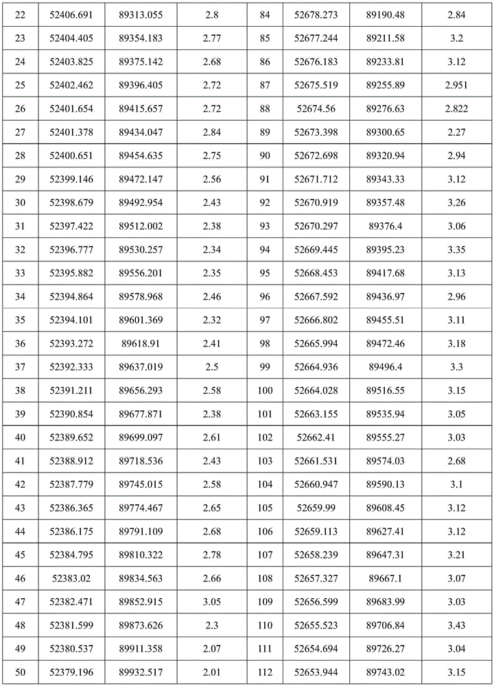

The thickness change of the coal seam in a working face of a certain coal mine is obtained according to the data in the table 1, as shown in fig. 2, it can be seen from the figure that the thickness of the coal seam in the working face is integrally represented by the characteristics of gradually increasing from the cutting hole to the mining stopping line and decreasing from the north to the south, the coal seam in the range of about 100m away from the cutting hole is thinner, the coal seam in the range of about 200m away from the mining stopping line is thicker, and the thickness is more than 3 m.
Analyzing the variation coefficient of the coal seam thickness:
the coal seam thickness variation coefficient calculation formula is as follows:
γ=s/xm

in the formula: gamma is the variation coefficient of coal thickness; n is the total number of coal points participating in evaluation; xm is the average coal thickness, m; s is the standard deviation of coal thickness variation; xi is the actually measured coal thickness m of the coal points.
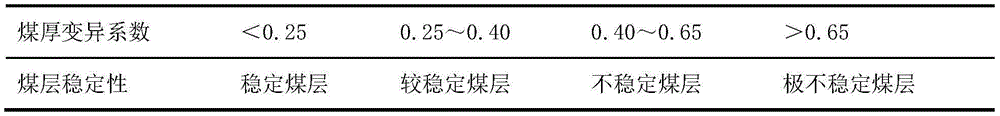
According to the coal seam thickness data listed in the table 1, the variation coefficient of the coal seam thickness in the working surface is 25.71%, and the stable coal seam in the working surface is obtained according to the standard in the table 2.
TABLE 2 reference table for variation coefficient of coal seam thickness
And (3) analyzing the change of the inclination angle of the coal seam:
according to the written data in the working face, the dip angle values of the coal seam in the working face conveying lane, the return airway and the cutting hole are counted and shown in a table 3, wherein in view of the trend that the elevation of the coal seam roof is increased from the cutting hole to the mining stopping line, the positive value in the dip angle statistic value of the coal seam represents the dip angle, and the negative value represents the dip angle.
TABLE 3 statistics table for dip angle of coal seam on certain working face of certain mine
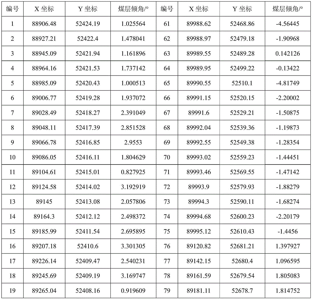

According to the data in table 3, it can be seen that the dip angle of the coal seam in the working surface range is generally-0.5-2.5 degrees, and the dip angle of the coal seam is relatively large in the middle of the working surface. And the change in the inclination of the coal seam in the working face is plotted as shown in fig. 3.
Analyzing the change trend of the coal seam thickness:
(1) preprocessing original data;
because the coordinates of the original data are all a plane rectangular coordinate system, the horizontal coordinates of the original data are eight, the vertical coordinates of the original data are seven, and the coal seam thickness value is only 1-2, under the condition, huge level differences can be generated between the coordinate values and the coal seam thickness value, different weight coefficients are endowed for coordinate variables and geological variables, normal equation set ill conditions can be caused as a result, the practical significance of calculation can be lost, and even overflow can be generated during calculation. The method only performs dimensional unification on the coordinate values, minimizes the coordinate values, and then equalizes the coordinate values to meet the requirement of trend analysis. The method comprises the following specific steps:
carrying out minimization transformation on a coordinate:
ui=xi-xmin 3.3
vi=yi-ymin 3.4
carrying out homogenization change:


multiplying ui 'and vi' by a coefficient C (the coefficient C is unified with the elevation value of the coal bed floor, and is taken as 10) respectively, so that the coordinate data meet the requirement of trend analysis processing, and after calculation is finished, converting the data into an original data format and outputting the original data format.
(2) Analyzing the thickness trend of the coal seam;
the trend analysis can be used for separating the information of the overall trend change and the local abnormity of the coal seam thickness, if the trend change reflects the overall regional form of the coal seam thickness, the local change can represent the local thickening or thinning of the coal seam thickness, and the trend change and the local change of the coal seam thickness are researched by using a trend surface analysis method, so that the change rule of the coal seam thickness in the region can be revealed.
Since the change of the terrestrial features in the space is both regular and random, the observed value of the terrestrial features at any point in the space can be regarded as the sum of the regional change features (trends) and the local change features (anomalies). The trend analysis is a multivariate statistical analysis method which divides the geoscience variable into regional variation component and local variation component, and identifies, separates and measures the trend and the abnormity of the geoscience variable by fitting a line (one-dimensional), a plane (two-dimensional) or a hypersurface (three-dimensional space) to the observed value of the geoscience variable in the space. The formula is as follows:
Ωground=ΩZone(s)+ΩDeflection
ΩDeflection=ΩOffice+ΩFollowed by
Wherein omegaZone(s)A part which reflects regular change under the control of regional factors (regional geological structure) of geological variables, namely regional change trend; omegaOfficeReflecting abnormal changes caused by local geological factors in a small range.
The trend surface analysis is a mathematical geological method used for reflecting the change property of the rock stratum curved surface in the space trend, analyzing the change rule and researching the local abnormity of the rock stratum curved surface. The data after the dimensional unification of the method is used for carrying out trend analysis on the thickness of the coal seam of a certain working face of a certain coal mine for 1-2 times, and a trend equation is shown in a table 4.
TABLE 4 equation table of thickness trend of coal seam on working face of certain mine


As can be seen from the trend surface graph (shown in figure 4) of the coal seam thickness for 1 time, the contour line of the coal seam thickness trend in a certain working surface of a certain mine is in a nearly parallel line state, and the change trend of the coal seam thickness is shown to be gradually reduced from the North West to the south east. The remaining graph (as shown in figure 5) of the trend surface of 1-time coal seam thickness is mainly in a positive remaining area on the working surface, and the coal seam thickness has a local thickening tendency; the negative surplus area is mainly in the southeast corner near the open-off cut range and the northwest area of the working face, and the thickness of the coal seam has a local thinning tendency.
As can be seen from the trend surface graph (figure 6) of the coal seam thickness of 2 times, the change trend of the coal seam thickness in a certain working surface of a certain mine is characterized by the fact that the cut hole is thin and the middle part is thick, and the coal seam thickness is the thinnest relative to other areas within the range of 0-50 m away from the southeast corner of the cut hole.
Analyzing a geological abnormal body;
a coal seam scouring belt is arranged at the position of a cutting hole of a certain working face close to an air inlet roadway, the range of the coal seam scouring belt is defined according to the tank wave CACT imaging result as shown in figure 7, and the area of the coal seam scouring belt is about 15090m2(ii) a And in the process of working face extraction, the hand-cut eye is subjected to writing and evidence obtaining, and the existence of the flushing zone in the range is verified.
In the result of CDM imaging of the reflected channel waves of the return airway of a certain working face, a reflecting interface exists inside the working face, and the area is analyzed and considered to have geological abnormality; in the working face, the position area is obtained, the handwriting evidence is carried out on the incisions, and the existence of the coal thickness abnormity in the range is confirmed as shown in figure 8.
The key technology for planning and cutting of the coal mining machine is as follows:
(1) heightening technology based on planning cutting
A refined top and bottom plate digital elevation model is constructed in advance by transparent geological modeling, the position and the posture of the coal mining machine are monitored by a real-time data sensing system of the coal mining machine, the current cutting boundary point of the roller is calculated, the current cutting boundary point and the top and bottom plate digital elevation model are subjected to superposition analysis, and finally the roller height adjustment value is determined. And the obtained roller adjustment value is issued to a coal mining machine controller for storage and corresponding control instructions are sent out, so that the automatic adjustment of the height of the coal mining machine roller is realized.
And (3) fusing a big data intelligent analysis decision-making system according to the transparent geological model, planning an obtained cutting curve, presetting the running speed and the turning back point position of the coal mining machine in different process sections by combining 22 coal mining processes of the coal mining machine, and controlling the speed reduction and reversing of the coal mining machine at the turning back position by setting a program advance speed reduction mechanism. And (3) the coal mining machine exits the planning cutting mode due to human interference or other factors, and the program of the coal mining machine automatically adjusts the speed to the set speed of the process section through speed comparison after entering the planning cutting mode again, so that the planning cutting speed of the coal mining machine is automatically adjusted.
Planning cutting control of the coal mining machine;
and performing big data decision analysis by combining the coal face multiple sensors through the established geological data model of the coal face to form a planned cutting curve, issuing the planned cutting curve to a coal cutter control system, and automatically cutting by the coal cutter control system according to the planned cutting curve.
The planning cutting process of the coal mining machine is as follows:
(1) communication confirmation
Before planning cutting, the coal mining machine firstly needs to confirm whether the communication between the coal mining machine and the precise control center is normal or not and whether the communication between the coal mining machine and the inertial navigation system is normal or not. 4C7, 4C8 and 4C9 data come from planning data of the accurate control center, and if the coal mining machine fails to communicate with the accurate control center, the 4C7, 4C8 and 4C9 ground colors are displayed in red and are normally bright. The 4CF data come from an inertial navigation system of the coal mining machine, and if the coal mining machine fails to communicate with the inertial navigation system, the 4CF ground color shows that the red color is normally bright.
(2) Planning cutting curve issuing
And after the coal mining machine and the accurate control center and the coal mining machine and the inertial navigation system are communicated and confirmed to be normal, the accurate control center issues a planned cutting curve to the coal mining machine.
(3) Planning cutting initiation
After the planned cutting curve is issued, quadrant setting is required. And setting an interface for planning a cutting quadrant, and setting the interface through the accurate control center according to the actual quadrant position of the coal mining machine. And after the quadrant setting is finished, entering a planning cutting mode, and operating the coal mining machine according to a planning direction.
(4) Planning cutting execution
During the execution of planned cutting, in the process of cutting coal in the middle parts of quadrants 1 and 12, the coal mining machine operates according to a planned cutting curve, and the cutting height of the drum is adaptively adjusted to ensure that the cutting height is matched with the planned cutting curve; when the coal mining machine enters the rest quadrant triangle coal stages to operate, the coal mining machine receives a turning point position command in accurate control, and planning, decelerating, stopping, reversing and other actions are carried out according to the turning point position. The execution process can be checked in real time through a planning cutting display system interface.
(5) Planning cutting exit
And when the operation is finished, the exit instruction can be issued by the accurate control center to finish.
Claims (6)
1. An adaptive cutting method for fusing geological baselines is characterized by comprising the following steps:
s1, integrating and analyzing geological data and measurement data, and constructing a multi-attribute fully mechanized coal mining face geological baseline model by using an interpolation algorithm;
s2, researching the mining process, setting the step length of the model mesh, carrying out mesh division on the coal bed digital model in the trend and the trend of the working face, and projecting the mesh to a two-dimensional horizontal plane;
s3, cutting a coal seam digital model according to a coal mining plan, projecting curved surfaces of a top plate and a bottom plate of the coal seam to a two-dimensional horizontal plane respectively, calculating a plane coordinate of an intersection point of a straight line segment and a grid line and elevations of the top plate and the bottom plate corresponding to the straight line segment, and connecting obtained control points of the top plate and the bottom plate according to the direction of the straight line segment in sequence to obtain an interface curve of the top plate and the bottom plate as a cutting curve;
s4, cutting is executed according to the cutting curve, and the cutting execution effect is evaluated;
and S5, correcting the planning curve according to the evaluation of the cutting execution effect.
2. The adaptive slicing method fused with geological baselines according to claim 1, wherein geological measurements include roadway landmark measurements, roadway slope measurements, floor elevation, roof elevation, coal thickness, coal seam occurrence and borehole positioning measurements.
3. The adaptive cutting method fused with geological baselines according to claim 1, wherein the geological baseline model of the multi-attribute fully mechanized mining face is constructed by performing coal seam thickness statistical analysis, coal seam thickness variation coefficient analysis, coal seam inclination angle variation analysis, coal seam thickness variation trend analysis and geological anomaly analysis.
4. The adaptive cutting method for fusing geologic baselines according to claim 1, wherein in S3, the working surface is taken as a research unit, and the comprehensive analysis of the geologic condition of the working surface is performed in combination with the development of various exploration techniques, and the contents of the comprehensive analysis include: the method comprises the following steps of coal seam thickness statistical analysis, coal seam thickness variation coefficient analysis, coal seam inclination angle variation analysis, coal seam thickness variation trend analysis and geological anomaly analysis.
5. The adaptive cutting method fusing the geological baseline according to claim 1, wherein the obtained cutting curve is planned according to a multi-attribute comprehensive mining working face geological baseline model, the running speeds and the turning back point positions of the coal mining machine in different process sections are preset by combining the coal mining process of the coal mining machine, and an advance deceleration mechanism is set to control the deceleration and reversing of the coal mining machine at the turning back position.
6. The adaptive cutting method fused with the geological baseline according to claim 1, wherein a coal mining machine operates according to a planned cutting curve, and the cutting height of a roller is adaptively adjusted to ensure the matching with the planned cutting curve; when the coal mining machine enters the other quadrant triangle coal stages to operate, the coal mining machine receives a turning point position command in the accurate control, and planning deceleration, stopping and reverse actions are carried out according to the turning point position.
Priority Applications (1)
| Application Number | Priority Date | Filing Date | Title |
|---|---|---|---|
| CN202110114128.0A CN113236249B (en) | 2021-01-27 | 2021-01-27 | Self-adaptive cutting method for fusing geological baselines |
Applications Claiming Priority (1)
| Application Number | Priority Date | Filing Date | Title |
|---|---|---|---|
| CN202110114128.0A CN113236249B (en) | 2021-01-27 | 2021-01-27 | Self-adaptive cutting method for fusing geological baselines |
Publications (2)
| Publication Number | Publication Date |
|---|---|
| CN113236249A true CN113236249A (en) | 2021-08-10 |
| CN113236249B CN113236249B (en) | 2024-08-13 |
Family
ID=77130180
Family Applications (1)
| Application Number | Title | Priority Date | Filing Date |
|---|---|---|---|
| CN202110114128.0A Active CN113236249B (en) | 2021-01-27 | 2021-01-27 | Self-adaptive cutting method for fusing geological baselines |
Country Status (1)
| Country | Link |
|---|---|
| CN (1) | CN113236249B (en) |
Cited By (3)
| Publication number | Priority date | Publication date | Assignee | Title |
|---|---|---|---|---|
| CN113513315A (en) * | 2021-08-13 | 2021-10-19 | 中煤科工开采研究院有限公司 | Cutting visualization and adjustment method for top and bottom plates of fully mechanized coal mining face |
| CN114033365A (en) * | 2021-09-29 | 2022-02-11 | 武汉长盛煤安科技有限公司 | Coal mining machine, early warning method of coal mining machine and electronic equipment |
| CN119878293A (en) * | 2025-01-13 | 2025-04-25 | 中国矿业大学 | Coal seam thickening zone identification method based on perforating information |
Citations (7)
| Publication number | Priority date | Publication date | Assignee | Title |
|---|---|---|---|---|
| CN106050228A (en) * | 2016-07-21 | 2016-10-26 | 太重煤机有限公司 | Three-drum shearer and shearing method of ultra-thick seams |
| CN106194181A (en) * | 2016-08-08 | 2016-12-07 | 西安科技大学 | Intelligent work surface coal-rock interface identification method based on geologic data |
| CN106296817A (en) * | 2016-08-08 | 2017-01-04 | 西安科技大学 | A kind of work surface coal seam based on geologic data three-dimensional modeling method |
| CN109630110A (en) * | 2019-01-18 | 2019-04-16 | 天地科技股份有限公司 | A kind of adaptive cutting control method of Seams thickness and electronic equipment |
| CN111364993A (en) * | 2020-03-20 | 2020-07-03 | 中国矿业大学 | Coal caving method based on coal seam geographic information system |
| CN111485880A (en) * | 2020-04-14 | 2020-08-04 | 北京龙软科技股份有限公司 | A method and device for generating intelligent mining prediction cutting line in coal mining face |
| CN112001982A (en) * | 2020-09-04 | 2020-11-27 | 陕西陕煤黄陵矿业有限公司 | Intelligent cutting method and system of shearer based on CT cutting of coal seam digital model |
-
2021
- 2021-01-27 CN CN202110114128.0A patent/CN113236249B/en active Active
Patent Citations (7)
| Publication number | Priority date | Publication date | Assignee | Title |
|---|---|---|---|---|
| CN106050228A (en) * | 2016-07-21 | 2016-10-26 | 太重煤机有限公司 | Three-drum shearer and shearing method of ultra-thick seams |
| CN106194181A (en) * | 2016-08-08 | 2016-12-07 | 西安科技大学 | Intelligent work surface coal-rock interface identification method based on geologic data |
| CN106296817A (en) * | 2016-08-08 | 2017-01-04 | 西安科技大学 | A kind of work surface coal seam based on geologic data three-dimensional modeling method |
| CN109630110A (en) * | 2019-01-18 | 2019-04-16 | 天地科技股份有限公司 | A kind of adaptive cutting control method of Seams thickness and electronic equipment |
| CN111364993A (en) * | 2020-03-20 | 2020-07-03 | 中国矿业大学 | Coal caving method based on coal seam geographic information system |
| CN111485880A (en) * | 2020-04-14 | 2020-08-04 | 北京龙软科技股份有限公司 | A method and device for generating intelligent mining prediction cutting line in coal mining face |
| CN112001982A (en) * | 2020-09-04 | 2020-11-27 | 陕西陕煤黄陵矿业有限公司 | Intelligent cutting method and system of shearer based on CT cutting of coal seam digital model |
Cited By (4)
| Publication number | Priority date | Publication date | Assignee | Title |
|---|---|---|---|---|
| CN113513315A (en) * | 2021-08-13 | 2021-10-19 | 中煤科工开采研究院有限公司 | Cutting visualization and adjustment method for top and bottom plates of fully mechanized coal mining face |
| CN113513315B (en) * | 2021-08-13 | 2023-12-08 | 中煤科工开采研究院有限公司 | Cutting visualization and adjusting method for top and bottom plates of fully mechanized mining face |
| CN114033365A (en) * | 2021-09-29 | 2022-02-11 | 武汉长盛煤安科技有限公司 | Coal mining machine, early warning method of coal mining machine and electronic equipment |
| CN119878293A (en) * | 2025-01-13 | 2025-04-25 | 中国矿业大学 | Coal seam thickening zone identification method based on perforating information |
Also Published As
| Publication number | Publication date |
|---|---|
| CN113236249B (en) | 2024-08-13 |
Similar Documents
| Publication | Publication Date | Title |
|---|---|---|
| LU501938B1 (en) | Method and system for intelligent analysis of big data on unmanned mining in mine | |
| EP3413098B1 (en) | Geologic structural model generation | |
| CN109630110A (en) | A kind of adaptive cutting control method of Seams thickness and electronic equipment | |
| Sun et al. | Building displacement measurement and analysis based on UAV images | |
| CN113236249A (en) | Self-adaptive cutting method for fusing geological baselines | |
| CN112883559A (en) | Planning cutting method and device based on big data system, storage medium and electronic device | |
| US20090299709A1 (en) | Virtual petroleum system | |
| CN118608709A (en) | Real-time 3D modeling of earthwork engineering, calculation of earthwork quantity and construction progress monitoring method based on drone measurement | |
| CN114943178A (en) | A three-dimensional geological model modeling method, device and computer equipment | |
| CN117593477B (en) | Three-dimensional geological map filling method integrating unmanned aerial vehicle three-dimensional model and geological map | |
| CN119200595B (en) | A coal mining robot integrating mechanical exploration and its autonomous navigation operation method | |
| CN110608721A (en) | A method and device for detecting the internal structure of a cave based on an unmanned aerial vehicle | |
| CN117369254A (en) | Gas prevention and control robot cluster control method and system based on complex geological conditions | |
| Pavlov et al. | Geosteering based on resistivity data and evolutionary optimization algorithm | |
| CN105844710B (en) | A kind of data detection method during geologic body gridding | |
| CN101587597B (en) | Construction method of complex-structure block geological model based on geological rule constraint | |
| WO2023223281A1 (en) | Automated monitoring of constructional sites | |
| CN120974408A (en) | A method for detecting deep concealed mineral deposits based on multi-source geological data fusion | |
| CN120469479A (en) | Efficient acquisition method and system for complex terrain geological exploration data based on UAV clusters | |
| CN120431285A (en) | Fault modeling method, device, equipment and storage medium based on seismic data | |
| CN113376697B (en) | Static correction method and device based on three-dimensional near-surface model | |
| CN119533221A (en) | A green and intelligent blasting rock breaking system and method | |
| CN114563819B (en) | Efficient interpretation method based on target fracture sensitivity attribute | |
| US11940589B2 (en) | Analyzing borehole paths using stratigraphic turning points | |
| CN118607773A (en) | An intelligent calculation method for the safety of excavation footage under different inclination angles of long-distance pipelines |
Legal Events
| Date | Code | Title | Description |
|---|---|---|---|
| PB01 | Publication | ||
| PB01 | Publication | ||
| SE01 | Entry into force of request for substantive examination | ||
| SE01 | Entry into force of request for substantive examination | ||
| GR01 | Patent grant | ||
| GR01 | Patent grant |