CN113077458A - Cloud and shadow detection method and system in remote sensing image - Google Patents
Cloud and shadow detection method and system in remote sensing image Download PDFInfo
- Publication number
- CN113077458A CN113077458A CN202110456805.7A CN202110456805A CN113077458A CN 113077458 A CN113077458 A CN 113077458A CN 202110456805 A CN202110456805 A CN 202110456805A CN 113077458 A CN113077458 A CN 113077458A
- Authority
- CN
- China
- Prior art keywords
- shadow
- cloud
- data
- remote sensing
- data set
- Prior art date
- Legal status (The legal status is an assumption and is not a legal conclusion. Google has not performed a legal analysis and makes no representation as to the accuracy of the status listed.)
- Granted
Links
Images


Classifications
-
- G—PHYSICS
- G06—COMPUTING OR CALCULATING; COUNTING
- G06T—IMAGE DATA PROCESSING OR GENERATION, IN GENERAL
- G06T7/00—Image analysis
- G06T7/0002—Inspection of images, e.g. flaw detection
-
- G—PHYSICS
- G06—COMPUTING OR CALCULATING; COUNTING
- G06N—COMPUTING ARRANGEMENTS BASED ON SPECIFIC COMPUTATIONAL MODELS
- G06N3/00—Computing arrangements based on biological models
- G06N3/02—Neural networks
- G06N3/04—Architecture, e.g. interconnection topology
- G06N3/045—Combinations of networks
-
- G—PHYSICS
- G06—COMPUTING OR CALCULATING; COUNTING
- G06N—COMPUTING ARRANGEMENTS BASED ON SPECIFIC COMPUTATIONAL MODELS
- G06N3/00—Computing arrangements based on biological models
- G06N3/02—Neural networks
- G06N3/08—Learning methods
- G06N3/084—Backpropagation, e.g. using gradient descent
-
- G—PHYSICS
- G06—COMPUTING OR CALCULATING; COUNTING
- G06T—IMAGE DATA PROCESSING OR GENERATION, IN GENERAL
- G06T7/00—Image analysis
- G06T7/10—Segmentation; Edge detection
- G06T7/187—Segmentation; Edge detection involving region growing; involving region merging; involving connected component labelling
-
- G—PHYSICS
- G06—COMPUTING OR CALCULATING; COUNTING
- G06T—IMAGE DATA PROCESSING OR GENERATION, IN GENERAL
- G06T2207/00—Indexing scheme for image analysis or image enhancement
- G06T2207/10—Image acquisition modality
- G06T2207/10032—Satellite or aerial image; Remote sensing
Landscapes
- Engineering & Computer Science (AREA)
- Theoretical Computer Science (AREA)
- Physics & Mathematics (AREA)
- General Physics & Mathematics (AREA)
- Biophysics (AREA)
- Evolutionary Computation (AREA)
- Health & Medical Sciences (AREA)
- Life Sciences & Earth Sciences (AREA)
- Artificial Intelligence (AREA)
- Biomedical Technology (AREA)
- Software Systems (AREA)
- Computational Linguistics (AREA)
- Data Mining & Analysis (AREA)
- Computer Vision & Pattern Recognition (AREA)
- General Health & Medical Sciences (AREA)
- Molecular Biology (AREA)
- Computing Systems (AREA)
- General Engineering & Computer Science (AREA)
- Mathematical Physics (AREA)
- Quality & Reliability (AREA)
- Image Analysis (AREA)
- Image Processing (AREA)
Abstract
The invention relates to a method and a system for detecting cloud and shadow in a remote sensing image, wherein the method comprises the steps of obtaining a data set of a test remote sensing image; inputting a test remote sensing image data set into the deep learning cloud detection model to obtain cloud and shadow distribution data; the deep learning cloud detection model is obtained by training a deep convolution neural network through a training sample set; the method for acquiring the training sample set comprises the following steps: acquiring a cloud and cloud shadow verification data set and a remote sensing image sample set of the same region; and expanding according to the cloud and the mark range of the shadow in the cloud shadow mark data set, and performing sample enhancement on the expanded shadow range and the corresponding region in the remote sensing image sample set to obtain the training sample set. According to the invention, the cloud and the mark range of the cloud shadow in the cloud shadow verification data set are expanded to obtain the expanded shadow area, so that the information expression accuracy of the sample is enhanced, and the detection precision can be improved.
Description
Technical Field
The invention relates to the technical field of image detection, in particular to a method and a system for detecting cloud and shadow in a remote sensing image.
Background
High-quality satellite remote sensing data is an important data source for carrying out ground surface coverage change monitoring, disaster assessment and resource investigation, but due to objective weather, most remote sensing images are affected by cloud and shadow to different degrees when being obtained, so that the acquisition of satellite images in a key period is limited, and the accuracy and integrity of corresponding information extraction are affected.
Cloud and shadow detection and repair are important methods for improving the utilization rate of satellite images and improving the information extraction precision. However, when a cloud and shadow detection model is constructed, due to the fact that the quantity and representativeness of training data are limited, repeated and mass-existing feature patterns can cause model over-learning in an iterative model optimization process, a small amount of objectively-existing features are generally difficult to capture well by the model, a data enhancement mode in a broad sense cannot effectively enhance deep-learning cloud and shadow detection training data, and finally the detection model is low in precision and poor in generalization.
Disclosure of Invention
The invention aims to provide a method and a system for detecting cloud and shadow in a remote sensing image, which can improve the detection precision.
In order to achieve the purpose, the invention provides the following scheme:
a method for detecting cloud and shadow in remote sensing images comprises the following steps:
acquiring a test remote sensing image data set;
inputting the test remote sensing image data set into a deep learning cloud detection model to obtain cloud and shadow distribution data; the deep learning cloud detection model is obtained by training a deep convolution neural network through a training sample set;
the method for acquiring the training sample set comprises the following steps:
acquiring a cloud and cloud shadow remote sensing image sample set and a marked data set of the same region;
and expanding according to the marking range of the shadow in the marking data set, and performing sample enhancement on the remote sensing image sample set by adopting the expanded shadow area to obtain the training sample set.
Preferably, the performing sample enhancement by using the expanded shadow region and the remote sensing image sample set to obtain the training sample set includes:
determining a region corresponding to the shadow region in the remote sensing image sample set as a target region;
merging the shadow region and the target region to obtain a first data set;
expanding the first data set to obtain a second data set;
and performing random linear disturbance on all image tile data in the second data set to obtain the training sample set.
Preferably, the merging the shadow region and the target region to obtain a first data set includes:
deleting the region without cloud interference in the target region to obtain a first region;
and merging the shadow area and the first area to obtain a first data set.
Preferably, the augmenting the first data set comprises:
cutting the picture data in the first data set into a plurality of image tile data with the same pixel size;
and if the image tile data contains cloud or shadow, translating, rotating or copying the image tile data.
Preferably, the random linear perturbation is performed on all image tile data in the second data set, including:
performing four independent random perturbations on each image tile data in the second data set according to a mode of y being kx + b;
wherein y is the image tile data after the disturbance enhancement, x is the image tile data, k is a first random parameter, and b is a second random parameter.
Preferably, the value range of the first random parameter is [1,1.5], and the value range of the second random parameter is [0,0.05 ].
Preferably, the determination method of the deep learning cloud detection model is as follows:
equally dividing all image tile data in the training sample set into a plurality of intervals according to the category proportion;
alternately extracting the image tile data from a plurality of the intervals by a random hierarchical sampling method;
inputting the extracted image tile data into the deep convolutional neural network, calculating the precision of the deep convolutional neural network under each iteration number by adopting a UNet framework, stopping iteration if a preset precision threshold is reached, determining the deep convolutional neural network reaching the preset precision threshold as the deep learning cloud detection model, and continuing training iteration if the preset precision threshold is not reached.
A cloud and shadow detection system in remote sensing images, comprising:
the acquisition unit is used for acquiring a test remote sensing image data set;
the testing unit is used for inputting the testing remote sensing image data set into a deep learning cloud detection model to obtain cloud and shadow distribution data; the deep learning cloud detection model is obtained by training a deep convolution neural network through a training sample set;
a training set obtaining unit, configured to obtain the training sample set; the training set obtaining unit specifically includes:
the system comprises a data set acquisition unit, a data processing unit and a data processing unit, wherein the data set acquisition unit is used for acquiring cloud and cloud shadow remote sensing image sample sets and marked data sets in the same region;
and the sample enhancement unit is used for expanding according to the marking range of the shadow in the marking data set and enhancing the sample of the remote sensing image sample set by adopting the expanded shadow area to obtain the training sample set.
Preferably, the sample enhancement unit includes:
the determining unit is used for determining a region corresponding to the shadow region in the remote sensing image sample set as a target region;
a merging unit, configured to merge the shadow region and the target region to obtain a first data set;
the expansion unit is used for expanding the first data set to obtain a second data set;
and the disturbance unit is used for carrying out random linear disturbance on all the image tile data in the second data set to obtain the training sample set.
Preferably, the extension unit includes:
a cropping subunit, configured to crop the picture data in the first data set into a plurality of image tile data with the same pixel size;
an expansion subunit, configured to translate, rotate, or copy the image tile data if the image tile data includes a cloud or a shadow.
Preferably, the disturbing unit includes:
a perturbation subunit, configured to perform four independent random perturbations on each image tile data in the second data set according to a manner of y ═ kx + b;
wherein y is the image tile data after the disturbance enhancement, x is the image tile data, k is a first random parameter, and b is a second random parameter.
According to the specific embodiment provided by the invention, the invention discloses the following technical effects:
in the invention, a test remote sensing image data set is obtained; inputting a test remote sensing image data set into the deep learning cloud detection model to obtain cloud and shadow distribution data; the deep learning cloud detection model is obtained by training a deep convolution neural network through a training sample set; the method for acquiring the training sample set comprises the following steps: acquiring a cloud and cloud shadow mark data set and a remote sensing image sample set of the same region; and expanding according to the cloud and the mark range of the shadow in the cloud shadow mark data set, and performing sample enhancement on the expanded shadow range and the corresponding region in the remote sensing image sample set to obtain the training sample set. According to the cloud and cloud shadow verification data set and the method, the marking range of the shadow in the cloud and cloud shadow verification data set is expanded to obtain the expanded shadow area, so that the expressiveness of the cloud shadow sample is enhanced, the edge part in the cloud shadow sample is complemented, and the information expression accuracy of the sample is enhanced. The method combines the shadow area and the area corresponding to the remote sensing image sample set and enhances the sample, so that the method can ensure that different equalized samples are contacted in the model training iteration process, ensure the stability of gradient reduction in each iteration and further improve the detection precision.
Drawings
In order to more clearly illustrate the embodiments of the present invention or the technical solutions in the prior art, the drawings needed to be used in the embodiments will be briefly described below, and it is obvious that the drawings in the following description are only some embodiments of the present invention, and it is obvious for those skilled in the art to obtain other drawings without inventive exercise.
FIG. 1 is a flow chart of a method of cloud and shadow detection in remote sensing images according to the present invention;
FIG. 2 is a flow chart of an overall cloud and shadow detection process in an embodiment of the invention;
fig. 3 is a block diagram of a cloud and shadow detection system in a remote sensing image according to the present invention.
Detailed Description
The technical solutions in the embodiments of the present invention will be clearly and completely described below with reference to the drawings in the embodiments of the present invention, and it is obvious that the described embodiments are only a part of the embodiments of the present invention, and not all of the embodiments. All other embodiments, which can be derived by a person skilled in the art from the embodiments given herein without making any creative effort, shall fall within the protection scope of the present invention.
The invention aims to provide a method and a system for detecting cloud and shadow in a remote sensing image, which can improve the detection precision.
In order to make the aforementioned objects, features and advantages of the present invention comprehensible, embodiments accompanied with figures are described in further detail below.
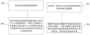
Fig. 1 is a flowchart of a method for detecting cloud and shadow in a remote sensing image according to the present invention, and as shown in fig. 1, the method for detecting cloud and shadow in a remote sensing image according to the present invention includes:
step 100: acquiring a test remote sensing image data set;
step 200: inputting the test remote sensing image data set into a deep learning cloud detection model to obtain cloud and shadow distribution data; the deep learning cloud detection model is obtained by training a deep convolution neural network through a training sample set;
the method for acquiring the training sample set comprises the following steps:
step 201: acquiring a cloud and cloud shadow remote sensing image sample set and a marked data set of the same region;
step 202: and expanding according to the marking range of the shadow in the marking data set, and performing sample enhancement on the remote sensing image sample set by adopting the expanded shadow area to obtain the training sample set.
Specifically, the label dataset is an L8-Biome dataset.
Optionally, the remote sensing image sample set is an Fmask sample set.
In this embodiment, the marking range of the cloud shadow in the L8-Biome data set is expanded, so as to increase the coverage range of the cloud shadow in the marking. The dilated shaded regions are then merged with the corresponding Fmask samples. The combination operation does not damage the range of the original cloud and cloud shadow marks in the Fmask, and only replaces the region without cloud interference in the Fmask. The enhancement method does complement the target and has a certain 'swelling' effect, and the expression of cloud and shadow samples is enhanced.
Preferably, the performing sample enhancement by using the expanded shadow region and the remote sensing image sample set to obtain the training sample set includes:
determining a region corresponding to the shadow region in the remote sensing image sample set as a target region;
merging the shadow region and the target region to obtain a first data set;
expanding the first data set to obtain a second data set;
and performing random linear disturbance on all image tile data in the second data set to obtain the training sample set.
Preferably, the merging the shadow region and the target region to obtain a first data set includes:
deleting the region without cloud interference in the target region to obtain a first region;
and merging the shadow area and the first area to obtain a first data set.
Preferably, the augmenting the first data set comprises:
cutting the picture data in the first data set into a plurality of image tile data with the same pixel size;
and if the image tile data contains cloud or shadow, translating, rotating or copying the image tile data.
In this embodiment, on the basis of completing the enhancement of the cloud and shadow expressiveness in the step, in order to avoid the problems of gradient disappearance, explosion, overfitting and the like in the training process, the number of cloud and shadow samples is further increased by adopting three modes of translation, rotation and pure copying, and then the sample balancing strategy is used to ensure the sample balancing in the training process.
The specific method comprises the following steps:
(1) cutting the cloud and shadow sample marking data and the corresponding remote sensing image into tile data with uniform pixel size, namely each time the model is independently and positively propagated and received;
(2) if the clipped tile data contains cloud and shadow categories, randomly selecting one of three methods of translation, rotation and pure copy to expand the tile;
(3) in order to ensure that the cloud shadow can be detected and learned in each propagation process in the iterative process, a sample balancing method in the training process is provided.
In general, the class in the DCNN training sample set with m classes is Ncls={0,1(,...,m)}。
For each training tile P in the set of training samplesnpAt least one, and at most m classes, where np is the number of picture elements in the tile. For each type of tile, the area fraction occupied is:
and:
with absolute sample equalisation ratio So that the area ratio of each class in each training tile can use vector (R)0,R1、…Rm) Then each tile can be represented as a coordinate in m-dimensional space of (R)0,R1、…Rm) The sample point of (2) indicates that the greater the distance between the sample point and the absolute equilibrium point, the more unbalanced the sample.
In remote sensing image cloud/shadow detection, the target types in the samples can be cloud, cloud shadow and other three types, and then the three types of samples are placed in a three-dimensional space middle plane (x + y + z is 1, 0< ═ x, y, z < ═ 1), and the whole data set can be divided into a plurality of intervals in an equal division mode by taking absolute equilibrium points (1/3,1/3 and 1/3) as the center of a circle. Samples in different intervals have different levels of sample equalization. Based on the dividing method, samples in different intervals are alternately extracted one sample at a time and put into a model training set by a random layered sampling method, model iterative training is carried out for 8 times every time, so that the model is ensured to contact with different equalized samples in the process of each iteration, and the gradient reduction stability in each iteration is ensured. It is noted that the number of sample equalization levels should be an integer multiple of the number of tiles used per iteration of the model to ensure that no drift occurs. This step is an enhancement based on sample equalization.
Preferably, the random linear perturbation is performed on all image tile data in the second data set, including:
performing four independent random perturbations on each image tile data in the second data set according to a mode of y being kx + b;
wherein y is the image tile data after the disturbance enhancement, x is the image tile data, k is a first random parameter, and b is a second random parameter.
Preferably, the value range of the first random parameter is [1,1.5], and the value range of the second random parameter is [0,0.05 ].
In this embodiment, after the problem of limited cloud shadow recognition performance is solved by enhancing the expressiveness of cloud and shadow samples and enhancing based on sample equalization in the step, cross-sensor generalization enhancement processing is performed to solve the problem of spectral differences between images acquired by different satellite sensors.
And the pixel values of the image are subjected to random linear disturbance to be close to the spectral distribution of the target data source. The linear disturbance unit is required to be the whole data of all four bands, and if different linear disturbances are performed on each band, internal relevant characteristics of each band in the data may be damaged, effective characteristics are damaged, and more redundant characteristics are generated.
And based on the basic training data set, performing linear disturbance on each training tile according to the condition that y is kx + b, wherein y is an enhancement result, x is an input tile, and values of k and b are randomly selected in a certain range. And (3) carrying out four independent random disturbances on each training tile, wherein the value range of k is [1,1.5], and the value range of b is [0,0.05 ].
Preferably, the determination method of the deep learning cloud detection model is as follows:
equally dividing all image tile data in the training sample set into a plurality of intervals according to the category proportion;
alternately extracting the image tile data from a plurality of the intervals by a random hierarchical sampling method;
inputting the extracted image tile data into the deep convolutional neural network, calculating the precision of the deep convolutional neural network under each iteration number by adopting a UNet framework, stopping iteration if a preset precision threshold is reached, determining the deep convolutional neural network reaching the preset precision threshold as the deep learning cloud detection model, and continuing training iteration if the preset precision threshold is not reached.
In this embodiment, the enhanced huge data set is used for deep learning cloud detection model training. This step is model training.
The basic principle is as follows: in the DCNN training, data are propagated in a network in a tensor form, and the scheme describes the data tensor by using a shape vector T containing four data, namely the number, the number of wave bands of each tile data, the width of each wave band image and the length of each wave band image.
In the training and application of the DCNN, the model can complete the forward propagation process, namely, the DCNN model f is used for extracting the characteristics of a batch of input data X and summarizing and outputting Y.
In the model training process, the model carries out optimization of model parameters through back propagation. That is, for the output of the DCNN forward propagation, Y ═ f (X) of the labeled sample X corresponding to the input datarefAnd constructing a model loss L according to a loss function g:
Lp=g(X,Xref);
where p is a parameter that can be learned in the model, minimizing L by gradient descentpAnd further optimizing and updating each parameter in f, and completing one back propagation, namely completing one model training iteration.
The specific process is as follows:
(1) convolution-based feature extraction
Convolution operation mode of Yi=Wi@ X + bias, wherein YiThe ith feature map, W, output for the convolutional layeriFor the corresponding ith convolution operator, @ denotes the convolution operation, X denotes the input feature map, and bias is the added offset after convolution.
(2) Model training using UNet framework
Inputting the sample data enhanced by the above steps, inputting the tensor shape as (48, 4, 256, 256), setting the basic learning rate as 1e-9, and setting the maximum iteration number as 1.72e7 times, namely 100 iteration rounds. After 100 complete iterations (epochs) of the training set, the overall accuracy of UNet at model training remains around 90%.
Evaluation indexes are as follows:
overall Accuracy (OA):
intersection over, IoU:
recall (Recall):
accuracy (Precision):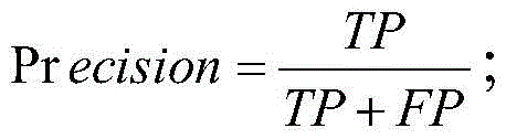
F1-score:
compared with the model precision which is not enhanced by data, the cloud shadow missing part is enhanced greatly, and the recall value of the shadow class is 0.490.
Optionally, the remote sensing image is input into the DCNN model obtained through the training in the above steps, cloud and shadow coverage detection in the image range is automatically completed, and the output result is cloud and shadow distribution data.
Fig. 3 is a module connection diagram of the cloud and shadow detection system in the remote sensing image, as shown in fig. 3, the cloud and shadow detection system in the remote sensing image provided by the present invention includes:
and the acquisition unit is used for acquiring the test remote sensing image data set.
The testing unit is used for inputting the testing remote sensing image data set into a deep learning cloud detection model to obtain cloud and shadow distribution data; the deep learning cloud detection model is obtained by training a deep convolution neural network through a training sample set.
A training set obtaining unit, configured to obtain the training sample set; the training set obtaining unit specifically includes:
the system comprises a data set acquisition unit, a data processing unit and a data processing unit, wherein the data set acquisition unit is used for acquiring cloud and cloud shadow remote sensing image sample sets and marked data sets in the same region;
and the sample enhancement unit is used for expanding according to the marking range of the shadow in the marking data set and enhancing the sample of the remote sensing image sample set by adopting the expanded shadow area to obtain the training sample set.
Preferably, the sample enhancement unit includes:
and the determining unit is used for determining the area corresponding to the shadow area in the remote sensing image sample set as a target area.
And the merging unit is used for merging the shadow area and the target area to obtain a first data set.
And the expansion unit is used for expanding the first data set to obtain a second data set.
And the disturbance unit is used for carrying out random linear disturbance on all the image tile data in the second data set to obtain the training sample set.
Preferably, the extension unit includes:
a cropping subunit, configured to crop the picture data in the first data set into a plurality of image tile data with the same pixel size;
an expansion subunit, configured to translate, rotate, or copy the image tile data if the image tile data includes a cloud or a shadow.
Preferably, the disturbing unit includes:
a perturbation subunit, configured to perform four independent random perturbations on each image tile data in the second data set according to a manner of y ═ kx + b;
wherein y is the image tile data after the disturbance enhancement, x is the image tile data, k is a first random parameter, and b is a second random parameter.
The invention has the following beneficial effects:
(1) through the enhancement of the cloud shadow sample expressiveness in the steps, the edge part in the cloud shadow sample is complemented, the information expression accuracy of the sample is enhanced, and the shadow boundary obtained by the trained model has an obvious over-detection phenomenon, so that most shadow edges are effectively detected, and the cloud or cloud shadow fuzzy edges can be effectively ensured not to interfere with subsequent image application after cloud removal. The cloud shadow detection method and the cloud shadow detection system improve the cloud shadow detection performance, reduce the shadow omission condition of the model by enhancing the optimization of the data set, and have an expansion mode beneficial to practical application.
(2) According to the enhancement based on sample balance in the steps, the invention can ensure that different balanced samples are contacted in the model training iteration process, and ensure the stability of gradient reduction in each iteration. The cloud shadow detection precision of the model is improved.
(3) Generally, data spectrums acquired by different satellite sensors are different, and the data spectrums are subjected to data enhancement in the step-by-step cross-sensor generalization enhancement, so that the spectrum expression in the training process of a (DCNN) deep convolution neural network is increased, the generalization performance of a model among different spectrum distributions is improved, and the generalization application among different data sources can be better performed. The method has a certain promotion effect on cloud and shadow detection of Sentinel-2 and GF-1 based on DCNN. Particularly, the cloud shadow detection performance of the DCNN model in the GF-1 data set is remarkably improved. The method improves the cross-sensor generalization performance, and the model obtained by training the sample after data enhancement can be suitable for various sensor data and has higher precision improvement.
The embodiments in the present description are described in a progressive manner, each embodiment focuses on differences from other embodiments, and the same and similar parts among the embodiments are referred to each other. For the system disclosed by the embodiment, the description is relatively simple because the system corresponds to the method disclosed by the embodiment, and the relevant points can be referred to the method part for description.
The principles and embodiments of the present invention have been described herein using specific examples, which are provided only to help understand the method and the core concept of the present invention; meanwhile, for a person skilled in the art, according to the idea of the present invention, the specific embodiments and the application range may be changed. In view of the above, the present disclosure should not be construed as limiting the invention.
Claims (10)
1. A method for detecting cloud and shadow in remote sensing images is characterized by comprising the following steps:
acquiring a test remote sensing image data set;
inputting the test remote sensing image data set into a deep learning cloud detection model to obtain cloud and shadow distribution data; the deep learning cloud detection model is obtained by training a deep convolution neural network through a training sample set;
the method for acquiring the training sample set comprises the following steps:
acquiring a cloud and cloud shadow remote sensing image sample set and a marked data set of the same region;
and expanding according to the marking range of the shadow in the marking data set, and performing sample enhancement on the remote sensing image sample set by adopting the expanded shadow area to obtain the training sample set.
2. The method for detecting cloud and shadow in remote sensing images according to claim 1, wherein the obtaining of the training sample set by sample enhancement of the shadow area obtained after expansion and the remote sensing image sample set comprises:
determining a region corresponding to the shadow region in the remote sensing image sample set as a target region;
merging the shadow region and the target region to obtain a first data set;
expanding the first data set to obtain a second data set;
and performing random linear disturbance on all image tile data in the second data set to obtain the training sample set.
3. The method for detecting cloud and shadow in remote sensing images according to claim 2, wherein said merging the shadow region with the target region to obtain a first data set comprises:
deleting the region without cloud interference in the target region to obtain a first region;
and merging the shadow area and the first area to obtain a first data set.
4. The method of claim 2, wherein the augmenting the first data set comprises:
cutting the picture data in the first data set into a plurality of image tile data with the same pixel size;
and if the image tile data contains cloud or shadow, translating, rotating or copying the image tile data.
5. The method of claim 2, wherein the randomly perturbing the image tile data in the second data set comprises:
performing four independent random perturbations on each image tile data in the second data set according to a mode of y being kx + b;
wherein y is the image tile data after the disturbance enhancement, x is the image tile data, k is a first random parameter, and b is a second random parameter.
6. The method for detecting the cloud and the shadow in the remote sensing image according to claim 5, wherein the value range of the first random parameter is [1,1.5], and the value range of the second random parameter is [0,0.05 ].
7. The method for detecting cloud and shadow in remote sensing images according to claim 1, wherein the method for determining the deep learning cloud detection model comprises the following steps:
equally dividing all image tile data in the training sample set into a plurality of intervals according to the category proportion;
alternately extracting the image tile data from a plurality of the intervals by a random hierarchical sampling method;
inputting the extracted image tile data into the deep convolutional neural network, calculating the precision of the deep convolutional neural network under each iteration number by adopting a UNet framework, stopping iteration if a preset precision threshold is reached, determining the deep convolutional neural network reaching the preset precision threshold as the deep learning cloud detection model, and continuing training iteration if the preset precision threshold is not reached.
8. A cloud and shadow detection system in remote sensing images, comprising:
the acquisition unit is used for acquiring a test remote sensing image data set;
the testing unit is used for inputting the testing remote sensing image data set into a deep learning cloud detection model to obtain cloud and shadow distribution data; the deep learning cloud detection model is obtained by training a deep convolution neural network through a training sample set;
a training set obtaining unit, configured to obtain the training sample set; the training set obtaining unit specifically includes:
the system comprises a data set acquisition unit, a data processing unit and a data processing unit, wherein the data set acquisition unit is used for acquiring cloud and cloud shadow remote sensing image sample sets and marked data sets in the same region;
and the sample enhancement unit is used for expanding according to the marking range of the shadow in the marking data set and enhancing the sample of the remote sensing image sample set by adopting the expanded shadow area to obtain the training sample set.
9. The system of claim 8, wherein the sample enhancement unit comprises:
the determining unit is used for determining a region corresponding to the shadow region in the remote sensing image sample set as a target region;
a merging unit, configured to merge the shadow region and the target region to obtain a first data set;
the expansion unit is used for expanding the first data set to obtain a second data set;
and the disturbance unit is used for carrying out random linear disturbance on all the image tile data in the second data set to obtain the training sample set.
10. The system for detecting clouds and shadows in remote-sensing images according to claim 9, wherein the extension unit includes:
a cropping subunit, configured to crop the picture data in the first data set into a plurality of image tile data with the same pixel size;
an expansion subunit, configured to translate, rotate, or copy the image tile data if the image tile data includes a cloud or a shadow.
Priority Applications (1)
| Application Number | Priority Date | Filing Date | Title |
|---|---|---|---|
| CN202110456805.7A CN113077458B (en) | 2021-04-25 | 2021-04-25 | Cloud and shadow detection method and system in remote sensing image |
Applications Claiming Priority (1)
| Application Number | Priority Date | Filing Date | Title |
|---|---|---|---|
| CN202110456805.7A CN113077458B (en) | 2021-04-25 | 2021-04-25 | Cloud and shadow detection method and system in remote sensing image |
Publications (2)
| Publication Number | Publication Date |
|---|---|
| CN113077458A true CN113077458A (en) | 2021-07-06 |
| CN113077458B CN113077458B (en) | 2023-09-19 |
Family
ID=76618971
Family Applications (1)
| Application Number | Title | Priority Date | Filing Date |
|---|---|---|---|
| CN202110456805.7A Active CN113077458B (en) | 2021-04-25 | 2021-04-25 | Cloud and shadow detection method and system in remote sensing image |
Country Status (1)
| Country | Link |
|---|---|
| CN (1) | CN113077458B (en) |
Cited By (1)
| Publication number | Priority date | Publication date | Assignee | Title |
|---|---|---|---|---|
| CN115995005A (en) * | 2023-03-22 | 2023-04-21 | 航天宏图信息技术股份有限公司 | Crop extraction method and device based on single-period high-resolution remote sensing image |
Citations (5)
| Publication number | Priority date | Publication date | Assignee | Title |
|---|---|---|---|---|
| CN106327452A (en) * | 2016-08-14 | 2017-01-11 | 曾志康 | Fragmented remote sensing image synthesis method and device for cloudy and rainy region |
| CN109670060A (en) * | 2018-12-10 | 2019-04-23 | 北京航天泰坦科技股份有限公司 | A kind of remote sensing image semi-automation mask method based on deep learning |
| WO2020015326A1 (en) * | 2018-07-19 | 2020-01-23 | 山东科技大学 | Remote sensing image cloud shadow detection method supported by earth surface type data |
| CN111161218A (en) * | 2019-12-10 | 2020-05-15 | 核工业北京地质研究院 | High-resolution remote sensing image change detection method based on twin convolutional neural network |
| CN111259955A (en) * | 2020-01-15 | 2020-06-09 | 国家测绘产品质量检验测试中心 | Method and system for reliable property detection of geographical national condition monitoring result |
-
2021
- 2021-04-25 CN CN202110456805.7A patent/CN113077458B/en active Active
Patent Citations (5)
| Publication number | Priority date | Publication date | Assignee | Title |
|---|---|---|---|---|
| CN106327452A (en) * | 2016-08-14 | 2017-01-11 | 曾志康 | Fragmented remote sensing image synthesis method and device for cloudy and rainy region |
| WO2020015326A1 (en) * | 2018-07-19 | 2020-01-23 | 山东科技大学 | Remote sensing image cloud shadow detection method supported by earth surface type data |
| CN109670060A (en) * | 2018-12-10 | 2019-04-23 | 北京航天泰坦科技股份有限公司 | A kind of remote sensing image semi-automation mask method based on deep learning |
| CN111161218A (en) * | 2019-12-10 | 2020-05-15 | 核工业北京地质研究院 | High-resolution remote sensing image change detection method based on twin convolutional neural network |
| CN111259955A (en) * | 2020-01-15 | 2020-06-09 | 国家测绘产品质量检验测试中心 | Method and system for reliable property detection of geographical national condition monitoring result |
Cited By (2)
| Publication number | Priority date | Publication date | Assignee | Title |
|---|---|---|---|---|
| CN115995005A (en) * | 2023-03-22 | 2023-04-21 | 航天宏图信息技术股份有限公司 | Crop extraction method and device based on single-period high-resolution remote sensing image |
| CN115995005B (en) * | 2023-03-22 | 2023-08-01 | 航天宏图信息技术股份有限公司 | Crop extraction method and device based on single-period high-resolution remote sensing image |
Also Published As
| Publication number | Publication date |
|---|---|
| CN113077458B (en) | 2023-09-19 |
Similar Documents
| Publication | Publication Date | Title |
|---|---|---|
| CN112836610B (en) | Land use change and carbon reserve quantitative estimation method based on remote sensing data | |
| CN110136170B (en) | Remote sensing image building change detection method based on convolutional neural network | |
| Biard et al. | Automated detection of weather fronts using a deep learning neural network | |
| CN118736425B (en) | Remote sensing image building change detection method and system based on morphological constraint | |
| CN110543906B (en) | Automatic skin recognition method based on Mask R-CNN model | |
| CN112001293B (en) | Remote sensing image object classification method combining multi-scale information and encoding and decoding network | |
| CN107230197B (en) | An objective method for determining the intensity of tropical cyclones based on satellite cloud images and RVM | |
| CN118447322A (en) | Wire surface defect detection method based on semi-supervised learning | |
| CN108446616B (en) | Road extraction method based on full convolution neural network ensemble learning | |
| CN109284779A (en) | Object detection method based on deep fully convolutional network | |
| CN113837134A (en) | A Wetland Vegetation Recognition Method Based on Object-Oriented Deep Learning Model and Transfer Learning | |
| CN114037679B (en) | A product image defect detection method and device based on unsupervised feature combination | |
| CN113108918A (en) | Method for inverting air temperature by using thermal infrared remote sensing data of polar-orbit meteorological satellite | |
| CN110992366A (en) | Image semantic segmentation method and device and storage medium | |
| CN117746252A (en) | A landslide detection method based on improved lightweight YOLOv7 | |
| CN116543315A (en) | Target detection method of remote sensing image based on foreground attention network | |
| CN119848780A (en) | Multisource data fusion and analysis method for river and lake remote sensing monitoring | |
| CN117710833B (en) | Surveying and mapping geographic information data collection method and related device based on cloud computing | |
| CN114998719A (en) | A forest fire prediction method based on deep learning and multi-source remote sensing data | |
| CN110852149A (en) | Vegetation index prediction method, system and equipment based on classification and regression tree algorithm | |
| CN113077458A (en) | Cloud and shadow detection method and system in remote sensing image | |
| CN112241676A (en) | A method for automatic identification of terrain debris | |
| US12057336B2 (en) | Estimating heights of defects in a wafer by scaling a 3D model using an artificial neural network | |
| CN114359300A (en) | An optimization method, device, system and storage medium for an image segmentation model | |
| CN116912582B (en) | Strong robustness hyperspectral target detection method based on characterization model |
Legal Events
| Date | Code | Title | Description |
|---|---|---|---|
| PB01 | Publication | ||
| PB01 | Publication | ||
| SE01 | Entry into force of request for substantive examination | ||
| SE01 | Entry into force of request for substantive examination | ||
| GR01 | Patent grant | ||
| GR01 | Patent grant |