CN112415552B - Vehicle position determining method and device and electronic equipment - Google Patents
Vehicle position determining method and device and electronic equipment Download PDFInfo
- Publication number
- CN112415552B CN112415552B CN202011289191.XA CN202011289191A CN112415552B CN 112415552 B CN112415552 B CN 112415552B CN 202011289191 A CN202011289191 A CN 202011289191A CN 112415552 B CN112415552 B CN 112415552B
- Authority
- CN
- China
- Prior art keywords
- vehicle
- lane
- road
- probability
- line
- Prior art date
- Legal status (The legal status is an assumption and is not a legal conclusion. Google has not performed a legal analysis and makes no representation as to the accuracy of the status listed.)
- Active
Links
Images


Classifications
-
- G—PHYSICS
- G01—MEASURING; TESTING
- G01S—RADIO DIRECTION-FINDING; RADIO NAVIGATION; DETERMINING DISTANCE OR VELOCITY BY USE OF RADIO WAVES; LOCATING OR PRESENCE-DETECTING BY USE OF THE REFLECTION OR RERADIATION OF RADIO WAVES; ANALOGOUS ARRANGEMENTS USING OTHER WAVES
- G01S19/00—Satellite radio beacon positioning systems; Determining position, velocity or attitude using signals transmitted by such systems
- G01S19/38—Determining a navigation solution using signals transmitted by a satellite radio beacon positioning system
- G01S19/39—Determining a navigation solution using signals transmitted by a satellite radio beacon positioning system the satellite radio beacon positioning system transmitting time-stamped messages, e.g. GPS [Global Positioning System], GLONASS [Global Orbiting Navigation Satellite System] or GALILEO
- G01S19/42—Determining position
-
- G—PHYSICS
- G01—MEASURING; TESTING
- G01C—MEASURING DISTANCES, LEVELS OR BEARINGS; SURVEYING; NAVIGATION; GYROSCOPIC INSTRUMENTS; PHOTOGRAMMETRY OR VIDEOGRAMMETRY
- G01C21/00—Navigation; Navigational instruments not provided for in groups G01C1/00 - G01C19/00
- G01C21/26—Navigation; Navigational instruments not provided for in groups G01C1/00 - G01C19/00 specially adapted for navigation in a road network
- G01C21/28—Navigation; Navigational instruments not provided for in groups G01C1/00 - G01C19/00 specially adapted for navigation in a road network with correlation of data from several navigational instruments
- G01C21/30—Map- or contour-matching
-
- G—PHYSICS
- G01—MEASURING; TESTING
- G01C—MEASURING DISTANCES, LEVELS OR BEARINGS; SURVEYING; NAVIGATION; GYROSCOPIC INSTRUMENTS; PHOTOGRAMMETRY OR VIDEOGRAMMETRY
- G01C21/00—Navigation; Navigational instruments not provided for in groups G01C1/00 - G01C19/00
- G01C21/20—Instruments for performing navigational calculations
-
- G—PHYSICS
- G01—MEASURING; TESTING
- G01C—MEASURING DISTANCES, LEVELS OR BEARINGS; SURVEYING; NAVIGATION; GYROSCOPIC INSTRUMENTS; PHOTOGRAMMETRY OR VIDEOGRAMMETRY
- G01C21/00—Navigation; Navigational instruments not provided for in groups G01C1/00 - G01C19/00
- G01C21/26—Navigation; Navigational instruments not provided for in groups G01C1/00 - G01C19/00 specially adapted for navigation in a road network
-
- G—PHYSICS
- G06—COMPUTING OR CALCULATING; COUNTING
- G06F—ELECTRIC DIGITAL DATA PROCESSING
- G06F18/00—Pattern recognition
- G06F18/20—Analysing
- G06F18/24—Classification techniques
- G06F18/241—Classification techniques relating to the classification model, e.g. parametric or non-parametric approaches
- G06F18/2415—Classification techniques relating to the classification model, e.g. parametric or non-parametric approaches based on parametric or probabilistic models, e.g. based on likelihood ratio or false acceptance rate versus a false rejection rate
-
- G—PHYSICS
- G06—COMPUTING OR CALCULATING; COUNTING
- G06F—ELECTRIC DIGITAL DATA PROCESSING
- G06F2218/00—Aspects of pattern recognition specially adapted for signal processing
- G06F2218/12—Classification; Matching
Landscapes
- Engineering & Computer Science (AREA)
- Radar, Positioning & Navigation (AREA)
- Remote Sensing (AREA)
- Physics & Mathematics (AREA)
- General Physics & Mathematics (AREA)
- Automation & Control Theory (AREA)
- Computer Networks & Wireless Communication (AREA)
- Theoretical Computer Science (AREA)
- Data Mining & Analysis (AREA)
- Artificial Intelligence (AREA)
- Life Sciences & Earth Sciences (AREA)
- Bioinformatics & Cheminformatics (AREA)
- Bioinformatics & Computational Biology (AREA)
- Computer Vision & Pattern Recognition (AREA)
- Evolutionary Biology (AREA)
- Evolutionary Computation (AREA)
- General Engineering & Computer Science (AREA)
- Probability & Statistics with Applications (AREA)
- Navigation (AREA)
- Traffic Control Systems (AREA)
Abstract
本申请公开了一种车辆位置的确定方法、装置及电子设备,涉及人工智能技术领域、自动驾驶技术领域、智能交通技术领域、计算机视觉技术领域。具体实现方案为:在确定车辆所处道路时,可以先获取待定位车辆的当前位置,及当前位置的前方道路的特征信息;并在导航地图中确定包括当前位置的预设区域内的至少一条道路;再根据前方道路的特征信息,确定待定位车辆处于各道路中的每个车道的概率;根据每个车道的概率,确定待定位车辆所处的目标道路;这样通过车道级的概率分布,定位待定位车辆最终所处的目标道路,可以在一定程度上提高定位的准确度,解决了现有技术中无法确定车辆当前所处道路的问题,从而可以准确地为用户出行提供辅助。

The present application discloses a method, device and electronic device for determining the position of a vehicle, and relates to the technical field of artificial intelligence, the technical field of automatic driving, the technical field of intelligent transportation, and the technical field of computer vision. The specific implementation scheme is: when determining the road where the vehicle is located, the current position of the vehicle to be positioned and the characteristic information of the road ahead of the current position can be obtained first; and at least one of the preset areas including the current position is determined in the navigation map Then, according to the characteristic information of the road ahead, determine the probability that the vehicle to be positioned is in each lane of each road; according to the probability of each lane, determine the target road where the vehicle to be positioned is located; in this way, through the probability distribution of the lane level, By locating the target road where the vehicle to be located is ultimately located, the accuracy of the positioning can be improved to a certain extent, which solves the problem that the current road of the vehicle cannot be determined in the prior art, so that it can accurately provide assistance for the user to travel.
Description
技术领域technical field
本申请涉及计算机技术领域,尤其涉及一种车辆位置的确定方法、装置及电子设备,具体可用于人工智能技术领域、自动驾驶技术领域、智能交通技术领域、计算机视觉技术领域。The present application relates to the field of computer technology, and in particular, to a method, device and electronic device for determining the position of a vehicle, which can be specifically used in the field of artificial intelligence technology, automatic driving technology, intelligent transportation technology, and computer vision technology.
背景技术Background technique
导航地图(SD Map)是一种广泛应用在行人、车辆的粗粒度道路定位以及路径规划导航等领域的地图。该导航地图的定位原理为:根据全球定位系统(Global PositioningSystem,GPS)定位的当前位置与导航地图中查找到的临近道路的中心线之间的距离,以及车身航向角与该邻近道路的航向角之间的差异,确定车辆当前所处道路。Navigation map (SD Map) is a map widely used in the fields of coarse-grained road positioning of pedestrians and vehicles, and route planning and navigation. The positioning principle of the navigation map is: the distance between the current position located according to the Global Positioning System (GPS) and the center line of the adjacent road found in the navigation map, and the heading angle of the vehicle body and the heading angle of the adjacent road The difference between them determines the road the vehicle is currently on.
然而,在实际场景中,由于导航地图路网复杂,尤其是在多并行道路的场景,若车辆与其中两条道路的中心线之间的距离相同,则无法确定车辆当前所处道路,从而无法准确地为用户出行提供辅助。However, in the actual scene, due to the complex road network of the navigation map, especially in the scene of multiple parallel roads, if the distance between the vehicle and the centerlines of two of the roads is the same, the road the vehicle is currently on cannot be determined, so it is impossible to determine the current road. Accurately provide assistance for user travel.
发明内容SUMMARY OF THE INVENTION
本申请提供了一种车辆位置的确定方法、装置及电子设备,可以在一定程度上提高定位的准确度,解决了现有技术中无法确定车辆当前所处道路的问题,从而可以准确地为用户出行提供辅助。The present application provides a method, device and electronic device for determining the position of a vehicle, which can improve the accuracy of positioning to a certain extent, solve the problem that the current road of the vehicle cannot be determined in the prior art, and can accurately provide users with accurate information. Travel assistance is provided.
根据本申请的一方面,提供了一种车辆位置的确定方法,该车辆位置的确定方法可以包括:According to an aspect of the present application, a method for determining the position of a vehicle is provided, and the method for determining the position of the vehicle may include:
获取待定位车辆的当前位置,及所述当前位置的前方道路的特征信息。其中,所述特征信息包括车道线的条数、各车道线的类型、及所述待定位车辆与各车道线之间的相对位置关系。Acquire the current position of the vehicle to be positioned and the feature information of the road ahead of the current position. The feature information includes the number of lane lines, the type of each lane line, and the relative positional relationship between the vehicle to be positioned and each lane line.
在导航地图中确定包括所述当前位置的预设区域内的至少一条道路。At least one road within a preset area including the current location is determined in the navigation map.
根据所述前方道路的特征信息,确定所述待定位车辆处于各所述道路中的每个车道的概率。According to the characteristic information of the road ahead, determine the probability that the vehicle to be located is in each lane of each of the roads.
根据所述待定位车辆处于各所述道路中的每个车道的概率,确定所述待定位车辆所处的目标道路。The target road on which the vehicle to be located is located is determined according to the probability that the vehicle to be located is located in each lane of the roads.
根据本申请的另一方面,提供了一种车辆位置的确定装置,该车辆位置的确定装置可以包括:According to another aspect of the present application, a vehicle position determination device is provided, and the vehicle position determination device may include:
获取模块,用于获取待定位车辆的当前位置,及所述当前位置的前方道路的特征信息;其中,所述特征信息包括车道线的条数、各车道线的类型、及所述待定位车辆与各车道线之间的相对位置关系。The acquisition module is used to acquire the current position of the vehicle to be positioned and the feature information of the road ahead of the current position; wherein the feature information includes the number of lane lines, the type of each lane line, and the vehicle to be positioned The relative positional relationship with each lane line.
处理模块,用于在导航地图中确定包括所述当前位置的预设区域内的至少一条道路;并根据所述前方道路的特征信息,确定所述待定位车辆处于各所述道路中的每个车道的概率;再根据所述待定位车辆处于各所述道路中的每个车道的概率,确定所述待定位车辆所处的目标道路。a processing module, configured to determine at least one road in a preset area including the current position in the navigation map; and determine that the vehicle to be positioned is on each of the roads according to the feature information of the road ahead The probability of the lane; and then determine the target road where the vehicle to be located is located according to the probability that the vehicle to be located is located in each lane of the roads.
根据本申请的另一方面,提供了一种电子设备,包括:According to another aspect of the present application, an electronic device is provided, comprising:
至少一个处理器;以及at least one processor; and
与所述至少一个处理器通信连接的存储器;其中,a memory communicatively coupled to the at least one processor; wherein,
所述存储器存储有可被所述至少一个处理器执行的指令,所述指令被所述至少一个处理器执行,以使所述至少一个处理器能够执行上述第一方面所述的车辆位置的确定方法。The memory stores instructions executable by the at least one processor, the instructions being executed by the at least one processor to enable the at least one processor to perform the determination of the vehicle position of the first aspect above method.
根据本申请的另一方面,提供了一种存储有计算机指令的非瞬时计算机可读存储介质,所述计算机指令用于使所述计算机执行上述第一方面所述的车辆位置的确定方法。According to another aspect of the present application, there is provided a non-transitory computer-readable storage medium storing computer instructions, the computer instructions being used to cause the computer to execute the method for determining the vehicle position according to the first aspect.
根据本申请的另一方面,提供了一种计算机程序产品,所述程序产品包括:计算机程序,所述计算机程序存储在可读存储介质中,电子设备的至少一个处理器可以从所述可读存储介质读取所述计算机程序,所述至少一个处理器执行所述计算机程序使得电子设备执行上述第一方面所述的车辆位置的确定方法。According to another aspect of the present application, a computer program product is provided, the program product comprising: a computer program, the computer program being stored in a readable storage medium, from which at least one processor of an electronic device can read The storage medium reads the computer program, and the at least one processor executes the computer program to cause the electronic device to execute the method for determining the vehicle position according to the first aspect.
根据本申请的技术方案,在确定车辆所处道路时,可以先获取待定位车辆的当前位置,及当前位置的前方道路的特征信息;其中,特征信息包括车道线的条数、各车道线的类型、及待定位车辆与各车道线之间的相对位置关系;并在导航地图中确定包括当前位置的预设区域内的至少一条道路;再根据前方道路的特征信息,确定待定位车辆处于各道路中的每个车道的概率;根据待定位车辆处于各道路中的每个车道的概率,确定待定位车辆所处的目标道路;这样通过车道级的概率分布,定位待定位车辆最终所处的目标道路,可以在一定程度上提高定位的准确度,解决了现有技术中无法确定车辆当前所处道路的问题,从而可以准确地为用户出行提供辅助。According to the technical solution of the present application, when determining the road where the vehicle is located, the current position of the vehicle to be positioned and the characteristic information of the road ahead of the current position can be obtained first; wherein the characteristic information includes the number of lane lines, the number of lane lines of each lane type, and the relative positional relationship between the vehicle to be located and each lane line; and determine at least one road in the preset area including the current position in the navigation map; and then determine the vehicle to be located according to the feature information of the road ahead. The probability of each lane in the road; according to the probability that the vehicle to be located is in each lane of each road, the target road where the vehicle to be located is determined; in this way, through the probability distribution of the lane level, the final location of the vehicle to be located is located. The target road can improve the positioning accuracy to a certain extent, solve the problem that the current road of the vehicle cannot be determined in the prior art, and thus can accurately provide assistance for the user to travel.
应当理解,本部分所描述的内容并非旨在标识本申请的实施例的关键或重要特征,也不用于限制本申请的范围。本申请的其它特征将通过以下的说明书而变得容易理解。It should be understood that the content described in this section is not intended to identify key or critical features of the embodiments of the application, nor is it intended to limit the scope of the application. Other features of the present application will become readily understood from the following description.
附图说明Description of drawings
附图用于更好地理解本方案,不构成对本申请的限定。其中:The accompanying drawings are used for better understanding of the present solution, and do not constitute a limitation to the present application. in:
图1是本申请实施例提供的一种并行道路场景的示意图;1 is a schematic diagram of a parallel road scene provided by an embodiment of the present application;
图2是根据本申请第一实施例提供的车辆位置的确定方法的流程示意图;2 is a schematic flowchart of a method for determining a vehicle position according to a first embodiment of the present application;
图3是根据本申请第一实施例提供的前方道路的示意图;3 is a schematic diagram of a road ahead provided according to the first embodiment of the present application;
图4是根据本申请第一实施例提供的预设区域内的至少一条道路的示意图;4 is a schematic diagram of at least one road in a preset area provided according to the first embodiment of the present application;
图5是根据本申请第二实施例提供的车辆位置的确定装置的结构示意图;5 is a schematic structural diagram of an apparatus for determining a vehicle position provided according to a second embodiment of the present application;
图6是根据本申请实施例的车辆位置的确定方法的电子设备的框图。FIG. 6 is a block diagram of an electronic device of a method for determining a vehicle position according to an embodiment of the present application.
具体实施方式Detailed ways
以下结合附图对本申请的示范性实施例做出说明,其中包括本申请实施例的各种细节以助于理解,应当将它们认为仅仅是示范性的。因此,本领域普通技术人员应当认识到,可以对这里描述的实施例做出各种改变和修改,而不会背离本申请的范围和精神。同样,为了清楚和简明,以下的描述中省略了对公知功能和结构的描述。Exemplary embodiments of the present application are described below with reference to the accompanying drawings, which include various details of the embodiments of the present application to facilitate understanding, and should be considered as exemplary only. Accordingly, those of ordinary skill in the art will recognize that various changes and modifications of the embodiments described herein can be made without departing from the scope and spirit of the present application. Also, descriptions of well-known functions and constructions are omitted from the following description for clarity and conciseness.
在本申请的实施例中,“至少一个”是指一个或者多个,“多个”是指两个或两个以上。“和/或”,描述关联对象的关联关系,表示可以存在三种关系,例如,A和/或B,可以表示:单独存在A,同时存在A和B,单独存在B这三种情况,其中A,B可以是单数或者复数。在本申请的文字描述中,字符“/”一般表示前后关联对象是一种“或”的关系。In the embodiments of the present application, "at least one" refers to one or more, and "a plurality" refers to two or more. "And/or", which describes the association relationship of the associated objects, means that there can be three kinds of relationships, for example, A and/or B, which can mean that A exists alone, A and B exist at the same time, and B exists alone, where A and B can be singular or plural. In the text description of this application, the character "/" generally indicates that the contextual object is an "or" relationship.
本申请实施例提供的车辆位置的确定方法可以应用于基于导航地图的车辆导航系统中。其中,导航地图是一种广泛应用在行人、车辆的粗粒度道路定位以及路径规划导航等领域的地图。导航地图(SD Map)不同于高精地图,高精地图中包括的车道信息比较丰富,例如车道线颜色、车道线的条数、以及车道线的类型以及车道的宽度等信息,而导航地图中包括的车道信息比较单一,仅包括车道数目。在基于导航地图的车辆导航系统中,车辆位置的确定装置根据车辆当前所处的道路进行导航提示时,需要先通过车辆中的GPS定位车辆的当前位置,并根据GPS定位的当前位置与导航地图中查找到的临近道路的中心线之间的距离,以及车身航向角与该邻近道路的航向角之间的差异,确定车辆当前所处道路;只有在确定车辆当前所处道路之后,才能基于导航地图进行准确的导航提示,例如,在前方第一个红绿灯处向左前方行驶,或者,在前方第一个红绿灯处向右前方行驶等,从而为用户的出行提供辅助。The method for determining the vehicle position provided by the embodiments of the present application can be applied to a vehicle navigation system based on a navigation map. Among them, the navigation map is a map widely used in the fields of coarse-grained road positioning of pedestrians and vehicles, and route planning and navigation. The navigation map (SD Map) is different from the high-precision map. The high-precision map includes more lane information, such as the color of the lane line, the number of lane lines, the type of lane line, and the width of the lane. The included lane information is relatively simple, including only the number of lanes. In the vehicle navigation system based on the navigation map, when the device for determining the vehicle position provides a navigation prompt according to the road where the vehicle is currently located, it is necessary to locate the current position of the vehicle through the GPS in the vehicle first, and then locate the current position according to the GPS positioning and the navigation map. The distance between the centerlines of the adjacent roads found in , and the difference between the body heading angle and the heading angle of the adjacent road, determine the road the vehicle is currently on; only after the road the vehicle is currently on can be based on navigation The map provides accurate navigation prompts, such as driving to the left at the first traffic light ahead, or driving to the right at the first traffic light ahead, etc., so as to provide assistance for the user's travel.
然而,在实际场景中,由于导航地图路网复杂,尤其是在多并行道路的场景,可能由于GPS定位的经纬度信息存在误差,基于该经纬度信息定位的车辆位置与其中两条道路的中心线之间的距离相同,若车辆位置与其中两条道路的中心线之间的距离相同,则无法确定车辆当前所处道路,从而无法准确地为用户出行提供辅助。However, in actual scenarios, due to the complex road network of the navigation map, especially in the scenario of multiple parallel roads, there may be errors in the latitude and longitude information of GPS positioning. If the distance between the vehicle position and the centerline of the two roads is the same, the road the vehicle is currently on cannot be determined, so that it cannot accurately provide assistance for the user to travel.
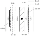
举例来说,在多并行道路的场景中,可参见图1所示,图1是本申请实施例提供的一种并行道路场景的示意图,该并行道路场景中包括并行的道路1和道路2,由于GPS定位的经纬度信息存在误差,使得该经纬度信息定位的车辆位置在道路1和道路2之间的绿化带中,并且该车辆位置与道路1的中心线1之间的距离S1、和当前定位的车辆位置与道路2的中心线2之间的距离S2近似相等,在该种情况下,无法确定车辆当前处于道路1和道路2中的哪个道路,从而无法准确地为用户出行提供辅助。For example, in a scenario of multiple parallel roads, reference can be made to FIG. 1 , which is a schematic diagram of a parallel road scene provided by an embodiment of the present application, and the parallel road scene includes parallel roads 1 and 2, Due to the error in the longitude and latitude information of GPS positioning, the position of the vehicle located by the longitude and latitude information is in the green belt between road 1 and road 2, and the distance S1 between the vehicle position and the centerline 1 of road 1, and the current positioning The distance S2 between the position of the vehicle and the centerline 2 of road 2 is approximately equal. In this case, it is impossible to determine which road among road 1 and road 2 the vehicle is currently on, so that it cannot accurately provide assistance for the user to travel.
为了在一定程度上准确地确定车辆当前所处道路,从而解决现有技术中无法确定车辆当前所处道路的问题,可以考虑借助当前导航地图中仅有的车道数目确定车辆当前所处道路。在借助当前导航地图中仅有的车道数目确定车辆当前所处道路时,考虑到若确定出的当前所处道路准确,则车辆行驶道路上的车道线数量与导航地图中的道路上的车道线数量匹配,并且车辆与各车道线之间的位置关系也匹配,例如车辆的左侧有一条车道线,右侧有两条车道线等,根据匹配结果就可以推算出车辆处于各道路中的每个车道的概率,再根据车辆处于各道路中的每个车道的概率,确定出车辆所处道路,这样可以在一定程度上提高定位的准确度,解决了现有技术中无法确定车辆当前所处道路的问题,从而可以准确地为用户出行提供辅助。In order to accurately determine the road on which the vehicle is currently located to a certain extent, so as to solve the problem that the road on which the vehicle currently locates cannot be determined in the prior art, it may be considered to determine the road on which the vehicle currently locates by using the number of lanes in the current navigation map. When determining the road the vehicle is currently on with the help of the number of lanes in the current navigation map, consider that if the determined road is accurate, the number of lane lines on the road where the vehicle travels is the same as the lane lines on the road in the navigation map. The number matches, and the positional relationship between the vehicle and each lane line is also matched. For example, there is one lane line on the left side of the vehicle and two lane lines on the right side. The probability of each lane, and then determine the road where the vehicle is located according to the probability that the vehicle is in each lane of each road, which can improve the accuracy of positioning to a certain extent, and solve the problem that the existing technology cannot determine the current location of the vehicle. Road problems, so that users can accurately provide assistance for travel.
基于上述构思,本申请实施例提供了一种车辆位置的确定方法,在确定车辆所处道路时,可以先获取待定位车辆的当前位置,及当前位置的前方道路的特征信息;其中,特征信息包括车道线的条数、各车道线的类型、及待定位车辆与各车道线之间的相对位置关系;并在导航地图中确定包括当前位置的预设区域内的至少一条道路;再根据前方道路的特征信息,确定待定位车辆处于各道路中的每个车道的概率;根据待定位车辆处于各道路中的每个车道的概率,确定待定位车辆所处的目标道路。Based on the above concept, an embodiment of the present application provides a method for determining the position of a vehicle. When determining the road where the vehicle is located, the current position of the vehicle to be located and the characteristic information of the road ahead of the current position can be obtained first; wherein, the characteristic information Including the number of lane lines, the type of each lane line, and the relative positional relationship between the vehicle to be located and each lane line; and determine at least one road in the preset area including the current position in the navigation map; The characteristic information of the road is used to determine the probability of the vehicle to be located in each lane of each road; the target road where the vehicle to be located is determined according to the probability of the vehicle to be located in each lane of each road.
可以理解的是,车道线的类型可以包括道路边缘线类型和非道路边缘线类型。道路边缘线类型的道路边缘线可以作为匹配的基准,用于辅助确定车辆所处的目标道路。车辆与车道线之间的相对位置关系是指车道线在车辆的左侧,或者车道线在车辆的右侧。It can be understood that the types of lane lines may include road edge line types and non-road edge line types. The road edge line of the road edge line type can be used as a matching reference to assist in determining the target road where the vehicle is located. The relative positional relationship between the vehicle and the lane line means that the lane line is on the left side of the vehicle, or the lane line is on the right side of the vehicle.
示例的,预设区域可以为一个圆形区域,例如,预设区域可以以当前位置为圆点,以预设长度为半径的一个圆形区域;或者,预设区域也可以为一个矩形区域,例如,预设区域可以以当前位置为中心点,以预设长度为对角线的一个矩形区域;或者,预设区域也可以为一个包括当前位置的不规则的区域,具体可以根据实际需要进行设置。For example, the preset area may be a circular area, for example, the preset area may be a circular area with the current position as a dot and a preset length as a radius; or, the preset area may also be a rectangular area, For example, the preset area may be a rectangular area with the current position as the center point and the preset length as the diagonal; alternatively, the preset area may also be an irregular area including the current position, which can be implemented according to actual needs. set up.
在本申请实施例中,通过设置预设区域,并在导航地图中确定包括当前位置的预设区域内的至少一条道路,其原因在于:虽然GPS定位会出现误差,但是其误差范围有限,因此,无需在较大区域内的道路中,对各道路进行一一筛选确定车辆当前所处道路,只需要在包括当前位置的预设区域内的道路中,确定车辆当前所处道路即可,这样可以有效地减少数据的处理量,从而提高处理效率。In the embodiment of the present application, by setting a preset area, and determining at least one road in the preset area including the current position in the navigation map, the reason is that although there will be errors in GPS positioning, the error range is limited, so , it is not necessary to screen each road one by one to determine the road where the vehicle is currently located in the roads in a larger area, it is only necessary to determine the road where the vehicle is currently located in the roads in the preset area including the current location, so that The amount of data processing can be effectively reduced, thereby improving processing efficiency.
可以看出,本申请实施例中,在确定车辆所处道路时,可以先获取待定位车辆的当前位置,及当前位置的前方道路的特征信息;其中,特征信息包括车道线的条数、各车道线的类型、及待定位车辆与各车道线之间的相对位置关系;并在导航地图中确定包括当前位置的预设区域内的至少一条道路;再根据前方道路的特征信息,确定待定位车辆处于各道路中的每个车道的概率;根据待定位车辆处于各道路中的每个车道的概率,确定待定位车辆所处的目标道路;这样通过车道级的概率分布,定位待定位车辆最终所处的目标道路,可以在一定程度上提高定位的准确度,解决了现有技术中无法确定车辆当前所处道路的问题,从而可以准确地为用户出行提供辅助。It can be seen that in the embodiment of the present application, when determining the road where the vehicle is located, the current position of the vehicle to be located and the characteristic information of the road ahead of the current position can be obtained first; The type of lane line and the relative positional relationship between the vehicle to be positioned and each lane line; and at least one road in the preset area including the current position is determined in the navigation map; and then according to the feature information of the road ahead, determine the to-be-positioned The probability that the vehicle is located in each lane of each road; according to the probability that the vehicle to be located is located in each lane of each road, the target road where the vehicle to be located is determined; in this way, through the probability distribution of the lane level, the location of the vehicle to be located is finally determined. The target road where the vehicle is located can improve the accuracy of positioning to a certain extent, and solve the problem that the current road of the vehicle cannot be determined in the prior art, so that it can accurately provide assistance for the user to travel.
下面,将通过具体的实施例对本申请提供的车辆位置的确定方法进行详细地说明。可以理解的是,下面这几个具体的实施例可以相互结合,对于相同或相似的概念或过程可能在某些实施例不再赘述。Hereinafter, the method for determining the vehicle position provided by the present application will be described in detail through specific embodiments. It can be understood that the following specific embodiments may be combined with each other, and the same or similar concepts or processes may not be repeated in some embodiments.
实施例一Example 1
图2是根据本申请第一实施例提供的车辆位置的确定方法的流程示意图,该车辆位置的确定方法可以由软件和/或硬件装置执行,例如,该硬件装置可以为车辆位置的确定装置,该车辆位置的确定装置可以为终端或者服务器。2 is a schematic flowchart of a method for determining a vehicle position according to a first embodiment of the present application. The method for determining a vehicle position may be performed by software and/or a hardware device, for example, the hardware device may be a vehicle position determining device, The device for determining the vehicle position may be a terminal or a server.
示例的,请参见图2所示,该车辆位置的确定方法可以包括:By way of example, referring to FIG. 2 , the method for determining the vehicle position may include:
S201、获取待定位车辆的当前位置,及当前位置的前方道路的特征信息。S201. Acquire the current position of the vehicle to be positioned and the feature information of the road ahead of the current position.
其中,待定位车辆的当前位置可以用待定位车辆当前所在的经纬度信息表示,特征信息包括车道线的条数、各车道线的类型、及待定位车辆与各车道线之间的相对位置关系。可以理解的是,前方道路是指处于当前位置的待定位车辆行驶方向上的前方道路。The current position of the vehicle to be located can be represented by the latitude and longitude information of the vehicle to be located, and the feature information includes the number of lane lines, the type of each lane line, and the relative positional relationship between the vehicle to be located and each lane line. It can be understood that the road ahead refers to the road ahead in the traveling direction of the vehicle to be located at the current position.
示例的,在获取待定位车辆的当前位置时,可以通过车辆自身设置的GPS获取待定位车辆的当前位置;也可以通过摄像头采集车辆前方的图像信息,进行图像匹配获取到待定位车辆的当前位置,也可以通过其它方式获取待定位车辆的当前位置,具体可以根据实际需要进行设置,在此,本申请实施例只是以通过车辆自身设置的GPS获取待定位车辆的当前位置为例进行说明,但并不代表本申请实施例仅局限于此。For example, when obtaining the current position of the vehicle to be positioned, the current position of the vehicle to be positioned can be obtained through the GPS set by the vehicle itself; the current position of the vehicle to be positioned can also be obtained through image matching by collecting image information in front of the vehicle through a camera. , the current position of the vehicle to be located can also be obtained in other ways, which can be specifically set according to actual needs. Here, the embodiment of the present application only uses the GPS set by the vehicle itself to obtain the current position of the vehicle to be located. It does not mean that the embodiments of the present application are limited to this.
示例的,在获取当前位置的前方道路的特征信息时,可以预先在待定位车辆的前方位置安装视觉传感器,并通过视觉传感器采集前方道路的特征信息,视觉传感器反馈的采集结果包括前方道路的特性信息,包括前方道路中包括的车道线的条数、各车道线的类型、及待定位车辆与各车道线之间的相对位置关系。For example, when acquiring the feature information of the road ahead of the current position, a vision sensor may be installed in advance in front of the vehicle to be positioned, and the feature information of the road ahead is collected by the vision sensor, and the collection result fed back by the visual sensor includes the characteristics of the road ahead. Information, including the number of lane lines included in the road ahead, the type of each lane line, and the relative positional relationship between the vehicle to be positioned and each lane line.
示例的,请参见图3所示,图3是根据本申请第一实施例提供的前方道路的示意图,可以先通过待定位车辆中的GPS获取车辆当前所在位置的经纬度信息,并根据该经纬度信息确定待定位车辆当前位置;并通过待定位车辆上安装的视觉传感器检测当前位置的前方道路中包括的车道线的条数、各车道线的类型、及待定位车辆与各车道线之间的相对位置关系,参见图3可以看出,通过视觉传感器检测到前方道路中包括三条条车道线以及该三条条车道线的类型,待定位车辆与该三条车道线之间的相对位置关系为:最左侧车道线在车辆的左侧,中间车道线和最右侧车道线均在车辆的右侧。可以理解的是,该三条车道线有可能是车辆当前道路中的所有车道线,也有可能是部分车道线。3 is a schematic diagram of the road ahead provided according to the first embodiment of the present application, the longitude and latitude information of the current location of the vehicle can be obtained through the GPS in the vehicle to be located, and the longitude and latitude information can be obtained according to the longitude and latitude information. Determine the current position of the vehicle to be positioned; and detect the number of lane lines included in the road ahead of the current position, the type of each lane line, and the relative relationship between the vehicle to be positioned and each lane line through the visual sensor installed on the vehicle to be positioned As can be seen from Figure 3, the visual sensor detects that the road ahead includes three lane lines and the types of the three lane lines. The relative positional relationship between the vehicle to be located and the three lane lines is: the leftmost The side lane line is on the left side of the vehicle, and the middle lane line and the rightmost lane line are on the right side of the vehicle. It can be understood that the three lane lines may be all lane lines on the current road of the vehicle, or may be part of the lane lines.
在通过GPS获取待定位车辆的当前位置后,可以在导航地图中查找确定包括当前位置的预设区域内的至少一条道路,即执行下述S202,从而在该至少一条道路中确定出待定位车辆当前所处道路。After the current position of the vehicle to be positioned is obtained through GPS, at least one road in the preset area including the current position can be searched and determined in the navigation map, that is, the following S202 is performed, so that the vehicle to be positioned is determined in the at least one road current road.
S202、在导航地图中确定包括当前位置的预设区域内的至少一条道路。S202. Determine at least one road in a preset area including the current position in the navigation map.
其中,至少一条的数量也可以为一个,也可以为多个,具体可以根据实际需要进行设置,在此,对于至少一条的取值,本申请实施例不做进一步地限制。The number of at least one item may also be one or multiple, and may be set according to actual needs. Here, the value of at least one item is not further limited in this embodiment of the present application.
示例的,预设区域可以为一个圆形区域,例如,预设区域可以以当前位置为圆点,以预设长度为半径的一个圆形区域;或者,预设区域也可以为一个矩形区域,例如,预设区域可以以当前位置为中心点,以预设长度为对角线的一个矩形区域;或者,预设区域也可以为一个包括当前位置的不规则的区域,具体可以根据实际需要进行设置。For example, the preset area may be a circular area, for example, the preset area may be a circular area with the current position as a dot and a preset length as a radius; or, the preset area may also be a rectangular area, For example, the preset area may be a rectangular area with the current position as the center point and the preset length as the diagonal; alternatively, the preset area may also be an irregular area including the current position, which can be implemented according to actual needs. set up.
在通过待定位车辆中的GPS获取车辆当前所在位置的经纬度信息,并根据该经纬度信息确定待定位车辆当前位置后,可以在导航地图中确定包括当前位置的预设区域内的至少一条道路,例如,可以以经纬度信息为圆点,确定预设半径区域的至少一条道路,可结合图4所示,图4是根据本申请第一实施例提供的预设区域内的至少一条道路的示意图,假设在导航地图中确定包括当前位置的预设区域内的道路包括图4所示的道路1和道路2。其中,道路1中包括四条车道线,最左侧车道线和最右侧车道线均为道路边缘线,中间两条车道线为非道路边缘线,该四条车道线形成三个车道,从左到右依次为车道1、车道2以及车道3;道路2包括三条车道线,最左侧车道线和最右侧车道线均为道路边缘线,中间一条为非道路边缘线,该三条线形成两个车道,从左到右依次为车道4以及车道5。After obtaining the latitude and longitude information of the current position of the vehicle through the GPS of the vehicle to be positioned, and determining the current position of the vehicle to be positioned according to the latitude and longitude information, at least one road in the preset area including the current position can be determined in the navigation map, for example , the latitude and longitude information can be used as dots to determine at least one road in the preset radius area, which can be combined with FIG. 4 . FIG. 4 is a schematic diagram of at least one road in the preset area provided according to the first embodiment of the present application. In the navigation map, it is determined that the roads within the preset area including the current position include the road 1 and the road 2 shown in FIG. 4 . Among them, Road 1 includes four lane lines, the leftmost lane line and the rightmost lane line are both road edge lines, and the two middle lane lines are non-road edge lines. The four lane lines form three lanes, from left to The right is lane 1, lane 2 and lane 3; road 2 includes three lane lines, the leftmost lane line and the rightmost lane line are both road edge lines, and the middle one is a non-road edge line, the three lines form two Lanes, from left to right, are lane 4 and lane 5.
在导航地图中确定出包括当前位置的预设区域内的至少一条道路之后,就可以根据前方道路的特征信息,在至少一个道路中确定出待定位车辆当前所处道路,即执行下述S203-S204:After at least one road in the preset area including the current position is determined in the navigation map, the road where the vehicle to be located is currently located in the at least one road may be determined according to the feature information of the road ahead, that is, the following S203- S204:
S203、根据前方道路的特征信息,确定待定位车辆处于各道路中的每个车道的概率。S203. Determine the probability that the vehicle to be positioned is in each lane of each road according to the feature information of the road ahead.
示例的,在根据前方道路的特征信息,确定待定位车辆处于各道路中的每个车道的概率时,可以包括至少两种可能的实现方式:For example, when determining the probability that the vehicle to be positioned is in each lane of each road according to the feature information of the road ahead, at least two possible implementations may be included:
在一种可能的实现方式中,若前方道路的特征信息中包括的各车道线的类型均为非道路边缘线类型,说明前方道路中不存在道路边缘线可以作为距离匹配的基准,因此,在该种可能的实现方式中,只需要根据车道线的条数、及待定位车辆与各车道线之间的相对位置关系进行车道线匹配,得到待定位车辆处于各道路中的每个车道的第一概率,并将第一概率确定待定位车辆处于各道路中的每个车道的概率。In a possible implementation manner, if the types of lane lines included in the feature information of the road ahead are all non-road edge line types, it means that there is no road edge line on the road ahead, which can be used as the benchmark for distance matching. In this possible implementation, it is only necessary to perform lane line matching according to the number of lane lines and the relative positional relationship between the vehicle to be positioned and each lane line, to obtain the number of lane lines where the vehicle to be positioned is located in each lane of each road. a probability, and the first probability determines the probability that the vehicle to be located is in each lane of each road.
在另一种可能的实现方式中,若前方道路的特征信息中包括的所有车道线的类型中存在道路边缘线类型,说明前方道路中存在道路边缘线可以作为距离匹配的基准,因此,在该种可能的实现方式中,该特征信息还包括待定位车辆与道路边缘线之间的距离,可以先根据车道线的条数、及待定位车辆与各车道线之间的相对位置关系进行车道线匹配,得到待定位车辆处于各道路中的每个车道的第一概率,并根据待定位车辆与道路边缘线之间的距离,确定待定位车辆处于各道路中的每个车道的第二概率;再根据第一概率和第二概率共同确定为待定位车辆处于各道路中的每个车道的概率。In another possible implementation, if there is a road edge line type in all the lane line types included in the feature information of the road ahead, it means that the road edge line exists in the road ahead and can be used as a reference for distance matching. Therefore, in this In a possible implementation manner, the feature information also includes the distance between the vehicle to be positioned and the road edge line, and the lane marking can be carried out according to the number of lane lines and the relative positional relationship between the vehicle to be positioned and each lane line. Matching to obtain the first probability that the vehicle to be positioned is in each lane of each road, and according to the distance between the vehicle to be positioned and the road edge line, determine the second probability of the vehicle to be positioned in each lane of each road; Then according to the first probability and the second probability, it is jointly determined as the probability that the vehicle to be positioned is in each lane of each road.
示例的,在根据第一概率和第二概率共同确定待定位车辆处于各道路中的每个车道的概率时,可以通过不断的观测,确定待定位车辆处于各道路中的每个车道的概率,具体可参见下述公式1:Exemplarily, when jointly determining the probability that the vehicle to be positioned is in each lane of each road according to the first probability and the second probability, the probability that the vehicle to be positioned is in each lane of each road can be determined through continuous observation, For details, please refer to the following formula 1:

其中,L0=log(p(x)/1-p(x)),p(x)为车道x的先验概率分布,x表示所有车道组成的向量,P(x|zt)包括了在同一t时刻不同的观测得到的第一概率和第二概率,zt为当前时刻的观测向量,随着新的观测向量zt不断引入,lt得以递推式估计。通过对lt(x)进行反变换,即可得到后验概率分布p(x│z1:t)。其中,P(x|z1:t)是指基于1到t时刻观测后,待定位车辆处于道路x的概率。举例说明,在初始状态下,道路上有四个车道,在无任何观测z的前提下,可以认为p(x0)=p(x1)=p(x2)=p(x3)=1/4=0.25。Among them, L 0 =log(p(x)/1-p(x)), p(x) is the prior probability distribution of lane x, x represents the vector composed of all lanes, and P(x|z t ) includes For the first probability and the second probability obtained from different observations at the same time t, z t is the observation vector at the current time. With the continuous introduction of new observation vectors z t , lt can be estimated recursively. By inverse transformation of l t (x), the posterior probability distribution p(x│z1:t) can be obtained. Among them, P(x|z1:t) refers to the probability that the vehicle to be located is on the road x after the observation from time 1 to t. For example, in the initial state, there are four lanes on the road, without any observation z, it can be considered that p(x0)=p(x1)=p(x2)=p(x3)=1/4= 0.25.
继续结合上述图3和图4所示,在根据图3所示的前方道路的特征信息,确定待定位车辆处于图4所示的各道路中的每个车道的概率时,在一种可能的实现方式中,假设图3所示的三条车道线均为非道路边缘线类型,说明前方道路中不存在道路边缘线可以作为距离匹配的基准,因此,在该种可能的实现方式中,可以仅通过车道线条数匹配,确定待定位车辆处于图4所示的道路1和道路2中各个道路的概率。具体过程为:图3所示的待定位车辆的左侧有一条车道线,右边有两条车道线;在进行车道线条数匹配时,由于图4所示的道路1中的车道1满足左侧有一条车道线,右侧有两条车道线,与图3所示的待定位车辆与车道线之间的相对位置关系匹配,说明待定位车辆当前可能处于车道1的概率较大,则可以确定出待定位车辆处于该车道1的第一概率;同理,由于图4所示的道路1中的车道2同样满足左侧有一条车道线,右侧有两条车道线,与图3所示的待定位车辆与车道线之间的相对位置关系匹配,说明待定位车辆当前可能处于车道2的概率较大,则可以确定出待定位车辆处于该车道2的第一概率;由于图4所示的道路1中的车道3满足左侧有一条车道线,但其右侧仅有一条车道线,与图3所示的待定位车辆与车道线之间的相对位置关系不匹配,说明待定位车辆当前可能处于车道3的概率较小,同样可以确定出待定位车辆处于该车道3的第一概率;且待定位车辆处于该车道1的第一概率和待定位车辆处于该车道2的第一概率均大于待定位车辆处于该车道3的第一概率;采用类似的方法,可以分别确定出待定位车辆处于图4所示的道路2中的车道4的第一概率和待定位车辆处于道路2中的车道5的第一概率。Continuing to combine the above-mentioned Fig. 3 and Fig. 4, when determining the probability that the vehicle to be located is in each lane of each road shown in Fig. 4 according to the feature information of the road ahead shown in Fig. 3, in a possible In the implementation manner, it is assumed that the three lane lines shown in FIG. 3 are all non-road edge line types, indicating that there is no road edge line in the road ahead, which can be used as the benchmark for distance matching. Therefore, in this possible implementation, only By matching the number of lane lines, the probability that the vehicle to be positioned is located on each of the roads 1 and 2 shown in FIG. 4 is determined. The specific process is as follows: the vehicle to be located shown in Fig. 3 has one lane line on the left side and two lane lines on the right side; when the number of lane lines is matched, since the lane 1 in the road 1 shown in Fig. 4 satisfies the left side There is one lane line and two lane lines on the right side, which match the relative positional relationship between the vehicle to be located and the lane lines shown in Figure 3, indicating that the vehicle to be located may be currently in lane 1 with a high probability, it can be determined The first probability that the vehicle to be located is in the lane 1; similarly, since the lane 2 in the road 1 shown in Figure 4 also satisfies that there is one lane line on the left and two lane lines on the right, which is the same as that shown in Figure 3 The relative positional relationship between the vehicle to be located and the lane line matches the relative positional relationship between the vehicle to be located and the lane line, indicating that the probability that the vehicle to be located may be currently in lane 2 is high, then the first probability that the vehicle to be located is in lane 2 can be determined; Lane 3 in road 1 satisfies that there is a lane line on the left side, but there is only one lane line on the right side, which does not match the relative positional relationship between the vehicle to be located and the lane line shown in Figure 3, indicating that the vehicle to be located. The probability that the vehicle to be located is currently in lane 3 is relatively small, and the first probability that the vehicle to be located is located in lane 3 can also be determined; and the first probability that the vehicle to be located is located in lane 1 and the first probability that the vehicle to be located is located in lane 2 are greater than the first probability that the vehicle to be located is in the lane 3; using a similar method, the first probability that the vehicle to be located is in the lane 4 of the road 2 shown in FIG. 4 and the vehicle to be located in the road 2 can be determined respectively. The first probability of lane 5.
在分别确定出待定位车辆处于图4所示的道路1中的车道1的第一概率、待定位车辆处于道路1中的车道2的第一概率、待定位车辆处于道路1中的车道3的第一概率、待定位车辆处于道路2中的车道4的第一概率、以及待定位车辆处于道路2中的车道5的第一概率后,由于图3所示的三条车道线均为非道路边缘线类型,说明前方道路中不存在道路边缘线可以作为距离匹配的基准,因此,在该种可能的实现方式中,可以直接将计算得到的待定位车辆处于图4所示的道路1中的车道1的第一概率,确定为待定位车辆处于道路1中的车道1的概率;将计算得到的待定位车辆处于道路1中的车道2的第一概率,确定为待定位车辆处于道路1中的车道2的概率,将计算得到的待定位车辆处于道路1中的车道3的第一概率,确定为待定位车辆处于道路1中的车道3的概率,将计算得到的待定位车辆处于道路2中的车道4的第一概率,确定为待定位车辆处于道路2中的车道4的概率,将计算得到的待定位车辆处于道路2中的车道5的第一概率,确定为待定位车辆处于道路2中的车道5的概率,从而得到待定位车辆处于图4所示的道路1和道路2中各个车道的概率。After determining the first probability that the vehicle to be positioned is in lane 1 of road 1 shown in FIG. 4 , the first probability that the vehicle to be positioned is in lane 2 of road 1 , and the probability that the vehicle to be positioned is in lane 3 of road 1 After the first probability, the first probability that the vehicle to be located is in lane 4 of road 2, and the first probability that the vehicle to be located is in lane 5 of road 2, since the three lane lines shown in FIG. 3 are all non-road edges Line type, indicating that there is no road edge line in the road ahead can be used as the benchmark for distance matching. Therefore, in this possible implementation, the calculated to-be-located vehicle can be directly placed in the lane of road 1 shown in FIG. 4 . The first probability of 1 is determined as the probability that the vehicle to be located is in lane 1 of road 1; the calculated first probability of the vehicle to be located in lane 2 of road 1 is determined as the probability that the vehicle to be located is in road 1. The probability of lane 2, the calculated first probability that the vehicle to be positioned is in lane 3 of road 1 is determined as the probability that the vehicle to be positioned is in lane 3 of road 1, and the calculated vehicle to be positioned is in road 2. The first probability of the vehicle to be located in the lane 4 of the road 2 is determined as the probability of the vehicle to be located in the lane 4 of the road 2, and the calculated first probability of the vehicle to be located in the lane 5 of the road 2 is determined as the vehicle to be located in the road 2. The probability of the lane 5 in the , so as to obtain the probability that the vehicle to be located is in each lane of the road 1 and the road 2 shown in FIG. 4 .
继续结合图3和图4所示,在另一种可能的实现方式中,假设图3所示的三条车道线的类型中存在道路边缘线类型,例如,三条车道线中最左侧车道线为道路边缘线,其它两条均为非道路边缘线,由于包括道路边缘线,说明前方道路中存在道路边缘线可以作为距离匹配的基准,因此,在该种可能的实现方式中,可以在通过车道线条数匹配的基础上,进一步结合待定位车辆与道路边缘线之间的距离匹配,共同确定待定位车辆处于图4所示的道路1和道路2中各个道路的概率。具体过程为:可以先计算待定位车辆处于图4所示的道路1和道路2中各个车道的第一概率,可以理解的是,在计算待定位车辆处于图4所示的道路1和道路2中各个车道的第一概率时,其计算方法与上述可能的实现方式中计算待定位车辆处于图4所示的道路1和道路2中各个车道的第一概率的计算方法相同,可参见上述可能的实现方式中计算待定位车辆处于图4所示的道路1和道路2中各个车道的第一概率的计算方法的相关描述,在此,本申请实施例不再进行赘述,从而确定出待定位车辆处于图4所示的道路1中的车道1的第一概率、待定位车辆处于道路1中的车道2的第一概率、待定位车辆处于道路1中的车道3的第一概率、待定位车辆处于道路2中的车道4的第一概率、以及待定位车辆处于道路2中的车道5的第一概率。Continuing to combine as shown in FIG. 3 and FIG. 4, in another possible implementation, it is assumed that there is a road edge line type in the types of the three lane lines shown in FIG. 3, for example, the leftmost lane line among the three lane lines is The road edge line and the other two are non-road edge lines. Since the road edge line is included, it means that there is a road edge line in the road ahead and can be used as the benchmark for distance matching. Therefore, in this possible implementation, it can be used in the passing lane. On the basis of matching the number of lines, further combining the distance matching between the vehicle to be located and the road edge line, the probability that the vehicle to be located is on each road in Road 1 and Road 2 shown in FIG. 4 is jointly determined. The specific process is as follows: the first probability that the vehicle to be located is located in each lane of road 1 and road 2 shown in When the first probability of each lane in the above-mentioned possible implementation manner is the same as the calculation method of calculating the first probability that the vehicle to be located is in each lane in road 1 and road 2 shown in FIG. 4 , please refer to the above possible The relevant description of the calculation method for calculating the first probability that the vehicle to be located is in each lane of the road 1 and the road 2 shown in FIG. 4 in the implementation manner of FIG. 4 . Here, the embodiment of the present application will not be repeated, so as to determine the to-be-located vehicle. The first probability that the vehicle is in lane 1 of road 1 shown in FIG. 4, the first probability that the vehicle to be located is in lane 2 of road 1, the first probability that the vehicle to be located is in lane 3 of road 1, the first probability that the vehicle to be located is in lane 3 of road 1, and the first probability that the vehicle to be located is in lane 2 of road 1. A first probability that the vehicle is in lane 4 of road 2 , and a first probability that the vehicle to be located is in lane 5 of road 2 .
在分别确定出待定位车辆处于图4所示的道路1和道路2中各个车道的第一概率后,由于图3所示的三条车道线包括道路边缘线,说明前方道路中存在道路边缘线可以作为距离匹配的基准,因此,在该种可能的实现方式中,由于图3所示的待定位车辆与最左侧道路边缘线之间的截距为S1,且S1小于一个标准车道线的宽度,由于图4所示的道路1中车道1的左侧车道线为道路边缘线,因此,图4所示的道路1中的车道1的宽度满足图3所示的车辆与道路边缘线之间的距离关系,说明待定位车辆当前可能处于车道1的概率较大,则可以确定出待定位车辆处于该车道1的第二概率,同时,也可以确定出待定位车辆处于道路1中车道2和车道3各自对应的第二概率;同理由于图4所示的道路2中车道4的左侧车道线为道路边缘线,因此,图4所示的道路2中的车道4的宽度也满足图3所示的车辆与道路边缘线之间的距离关系,说明待定位车辆当前可能处于车道4的概率较大,则可以确定出待定位车辆处于该车道4的第二概率,同时,也可以确定出待定位车辆处于道路2中车道5对应的第二概率。After determining the first probability that the vehicle to be located is in each lane of road 1 and road 2 shown in FIG. 4, since the three lane lines shown in FIG. As a reference for distance matching, in this possible implementation, since the intercept between the vehicle to be positioned and the leftmost road edge line shown in FIG. 3 is S1, and S1 is smaller than the width of a standard lane line , since the left lane line of the lane 1 in the road 1 shown in FIG. 4 is the road edge line, the width of the lane 1 in the road 1 shown in FIG. 4 satisfies the width between the vehicle and the road edge line shown in FIG. 3 distance relationship, indicating that the probability that the vehicle to be located may be currently in lane 1 is relatively high, then the second probability that the vehicle to be located is located in lane 1 can be determined, and at the same time, it can also be determined that the vehicle to be located is located in lane 2 and lane 2 in road 1. The second probability corresponding to each lane 3; for the same reason, the left lane line of the lane 4 in the road 2 shown in FIG. 4 is the road edge line, so the width of the lane 4 in the road 2 shown in FIG. The distance relationship between the vehicle and the road edge line shown in 3 shows that the probability that the vehicle to be located may be currently in lane 4 is relatively high, then the second probability that the vehicle to be located is in lane 4 can be determined, and at the same time, it can also be determined The second probability corresponding to the vehicle to be located in the lane 5 in the road 2 is obtained.
上述在确定待定位车辆处于图4所示的道路1和道路2中各个车道的第二概率时,只是以三条车道线包括最左侧一条道路边缘线为例进行说明,可以理解的是,若三条车道线中最右侧车道线也是道路边缘线,则针对于道路1和道路2中的每一个车道,基于图3所示的待定位车辆与最右侧道路边缘线之间的截距为S3,也可以计算得到另一组第二概率,在该种情况下,在确定待定位车辆处于道路1和道路2中各个车道的最终第二概率时,可以根据待定位车辆处于道路1和道路2中各个车道的两个第二概率,共同确定待定位车辆处于道路1和道路2中各个车道的最终第二概率。When determining the second probability that the vehicle to be located is in each lane in road 1 and road 2 shown in FIG. 4 , only three lane lines including the leftmost road edge line are used as an example for description. It can be understood that if The rightmost lane line among the three lane lines is also the road edge line, then for each lane in Road 1 and Road 2, the intercept between the vehicle to be positioned and the rightmost road edge line shown in Figure 3 is: S3, another set of second probabilities can also be obtained by calculation. In this case, when determining the final second probability that the vehicle to be located is located in each lane of road 1 and road 2, the vehicle to be located can be located on road 1 and road The two second probabilities of each lane in 2 jointly determine the final second probability that the vehicle to be positioned is in each lane in road 1 and road 2.
在分别确定出待定位车辆处于图4所示的道路1和道路2中各个车道的第一概率和第二概率之后,针对道路1和道路2中的每一个车道,以道路1中的车道1为例,则可以根据待定位车辆处于图4所示的道路1中的车道1的第一概率和待定位车辆处于车道1的第二概率共同确定待定位车辆处于道路1中的车道1的概率,从而得到待定位车辆处于图4所示的道路1和道路2中各个车道的概率。After determining the first probability and the second probability that the vehicle to be located is in each lane of road 1 and road 2 shown in FIG. 4 , for each lane of road 1 and road 2 For example, the probability that the vehicle to be located is in lane 1 of road 1 can be jointly determined according to the first probability that the vehicle to be located is located in lane 1 of road 1 shown in FIG. 4 and the second probability that the vehicle to be located is located in lane 1 , so as to obtain the probability that the vehicle to be located is in each lane of road 1 and road 2 shown in FIG. 4 .
这样在得到待定位车辆处于各道路中的每个车道的概率后,就可以根据待定位车辆处于各道路中的每个车道的概率,确定待定位车辆所处的目标道路,即执行下述S204;这样通过车道级的概率分布,定位待定位车辆最终所处的目标道路,可以在一定程度上提高定位的准确度,解决了现有技术中无法确定车辆当前所处道路的问题,从而可以准确地为用户出行提供辅助。In this way, after obtaining the probability that the vehicle to be located is located in each lane of each road, the target road where the vehicle to be located can be determined according to the probability that the vehicle to be located is located in each lane of each road, that is, the following S204 is performed. ; In this way, the target road where the vehicle to be located is finally located through the probability distribution of the lane level can improve the positioning accuracy to a certain extent, and solve the problem that the current road of the vehicle cannot be determined in the prior art, so that the vehicle can be accurately located. Provide assistance for users to travel.
S204、根据待定位车辆处于各道路中的每个车道的概率,确定待定位车辆所处的目标道路。S204: Determine the target road where the vehicle to be located is located according to the probability that the vehicle to be located is located in each lane of each road.
示例的,在根据待定位车辆处于各道路中的每个车道的概率,确定待定位车辆所处的目标道路时,与现有技术类似的是,同样是根据待定位车辆当前位置与各道路中的基准线之间的距离、及待定位车辆的车身航向角与各道路航向角之间的角度差异,确定待定位车辆处于各道路的概率;再在待定位车辆处于各道路的概率中,确定最大概率对应的道路;并将最大概率对应的道路确定为待定位车辆所处的目标道路,从而确定出待定位车辆当前所处的目标道路。但是,与现有技术中不同的是,在本申请实施例中,不是直接将各道路的中心线作为道路中的基准线,而是通过根据待定位车辆处于各道路中每个车道的概率,计算确定各道路中的基准线。For example, when determining the target road where the vehicle to be located is located according to the probability that the vehicle to be located is located in each lane of each road, similar to the prior art, it is also based on the relationship between the current position of the vehicle to be located and the road in each road. The distance between the reference lines and the angle difference between the body heading angle of the vehicle to be positioned and the heading angle of each road, determine the probability that the vehicle to be positioned is on each road; and then determine the probability that the vehicle to be positioned is on each road. The road corresponding to the maximum probability is determined; and the road corresponding to the maximum probability is determined as the target road where the vehicle to be located is located, so as to determine the current target road where the vehicle to be located is located. However, unlike the prior art, in the embodiment of the present application, the center line of each road is not directly used as the reference line in the road, but by the probability that the vehicle to be positioned is in each lane of each road, The calculation determines the baseline in each road.
其中,在计算各道路航向角时,由于导航地图会提供地图道路中心线的一系列采样点经纬度以及车道数信息,通过这一系列采样点经纬度和车道数可以计算得到各道路航向角,可通过道路航向角theta=arctan(dy/dx)描述,其中,dy表示正北方向的移动距离,dx表示正东方向的移动距离。在确定车辆自身航向角时,可以基于GPS获取的位置轨迹,并采用类似原理计算得到车辆自身航向角。Among them, when calculating the heading angle of each road, since the navigation map will provide a series of latitude and longitude of sampling points and the number of lanes of the map road centerline, the heading angle of each road can be calculated through the latitude and longitude of the sampling point and the number of lanes. The road heading angle is described by theta=arctan(dy/dx), where dy represents the moving distance in the true north direction, and dx represents the moving distance in the true east direction. When determining the vehicle's own heading angle, the vehicle's own heading angle can be calculated based on the position trajectory obtained by GPS and using a similar principle.
示例的,在根据待定位车辆处于各道路中每个车道的概率,确定各道路中的基准线时,确定各车道的左侧车道线的特征值,特征值用于标识左侧车道线,以3条车道为例,第一条车道的左侧车道线的特征值可以为0,第二条车道的左侧车道线的特征值可以为1,第三条车道的左侧车道线的特征值可以为2等;分别计算各车道的左侧车道线的特征值与待定位车辆处于各道路中每个车道的概率的乘积,并计算各乘积的和,针对每条道路,以道路中最左侧车道线为基准,将与最左侧车道线的距离为第一距离的平行线确定为基准线,第一距离为根据各乘积的和确定的。For example, when determining the reference line in each road according to the probability that the vehicle to be located is in each lane of each road, the eigenvalue of the left lane line of each lane is determined, and the eigenvalue is used to identify the left lane line to Taking three lanes as an example, the eigenvalue of the left lane line of the first lane can be 0, the eigenvalue of the left lane line of the second lane can be 1, and the eigenvalue of the left lane line of the third lane It can be 2, etc.; calculate the product of the feature value of the left lane line of each lane and the probability that the vehicle to be positioned is in each lane of each road, and calculate the sum of each product. The side lane line is used as the reference, and the parallel line whose distance from the leftmost lane line is the first distance is determined as the reference line, and the first distance is determined according to the sum of the products.
继续结合上述S203中关于图3和图4的相关描述,在根据待定位车辆处于图4所示的道路1和道路2中各个车道的概率确定道路1和车道2的基准线时,针对图4所示的道路1,假设道路1中的车道1的左侧车道线的特征值为0,车道2的左侧车道线的特征值为1,车道3的左侧车道线的特征值为2,且通过上述S203计算得到待定位车辆处于车道1的概率为0.4,待定位车辆处于车道2的概率为0.4,及待定位车辆处于车道3的概率为0.2,分别计算各车道的左侧车道线的特征值与待定位车辆处于各道路中每个车道的概率的乘积,并计算各乘积的和,即计算0*0.4+1*0.4+2*0.2=0.8;再计算0.8*标准车道宽度3.75的乘积,乘积为3,则以道路1中最左侧车道线为基准,将与最左侧车道线的距离为3米的平行线确定为道路1中的基准线1,从而确定出道路1中的基准线1;同理,针对图4所示的道路2,假设道路2中的车道4的左侧车道线的特征值为0,车道5的左侧车道线的特征值为1,且通过上述S203计算得到待定位车辆处于车道4的概率为0.6,待定位车辆处于车道5的概率为0.4,分别计算各车道的左侧车道线的特征值与待定位车辆处于各道路中每个车道的概率的乘积,并计算各乘积的和,即计算0*0.6+1*0.4=0.4;再计算0.4*标准车道宽度3.75的乘积,乘积为1.5,则以道路2中最左侧车道线为基准,将与最左侧车道线的距离为1.5米的平行线确定为道路2中的基准线2,从而确定出道路2中的基准线2。Continuing to combine the relevant descriptions of FIG. 3 and FIG. 4 in the above S203, when determining the reference lines of road 1 and lane 2 according to the probability that the vehicle to be located is in each lane of road 1 and road 2 shown in FIG. 4, for FIG. 4 As shown in road 1, assuming that the eigenvalue of the left lane line of lane 1 in road 1 is 0, the eigenvalue of the left lane line of lane 2 is 1, and the eigenvalue of the left lane line of lane 3 is 2, And through the above calculation in S203, the probability that the vehicle to be located is in lane 1 is 0.4, the probability that the vehicle to be located is in lane 2 is 0.4, and the probability that the vehicle to be located is in lane 3 is 0.2, respectively. Calculate the probability of the left lane line of each lane. The product of the feature value and the probability that the vehicle to be located is in each lane of each road, and the sum of each product is calculated, that is, 0*0.4+1*0.4+2*0.2=0.8; then calculate 0.8*standard lane width 3.75 Product, the product is 3, then the leftmost lane line in road 1 is used as the benchmark, and the parallel line with a distance of 3 meters from the leftmost lane line is determined as the benchmark line 1 in road 1, so as to determine the road 1. for the reference line 1 of The above S203 calculates that the probability that the vehicle to be positioned is in lane 4 is 0.6, and the probability that the vehicle to be positioned is in lane 5 is 0.4. Calculate the product of probabilities, and calculate the sum of each product, that is, calculate 0*0.6+1*0.4=0.4; then calculate the product of 0.4*standard lane width 3.75, the product is 1.5, then take the leftmost lane line in road 2 as the benchmark , the parallel line with the distance of 1.5 meters from the leftmost lane line is determined as the reference line 2 in the road 2, so as to determine the reference line 2 in the road 2.
在分别确定出道路1和道路2中的基准线后,就可以根据待定位车辆当前位置与道路1中的基准线1之间的距离、及待定位车辆的车身航向角与各道路航向角之间的角度差异,确定待定位车辆处于道路1的概率;并根据待定位车辆当前位置与道路2中的基准线2之间的距离、及待定位车辆的车身航向角与各道路航向角之间的角度差异,确定待定位车辆处于道路2的概率;再在这两个概率中确定较大的概率,假设待定位车辆处于道路1的概率大于待定位车辆处于道路2的概率,则将道路1确定为待定位车辆当前所处的目标道路。After the reference lines in Road 1 and Road 2 are respectively determined, the distance between the current position of the vehicle to be positioned and the reference line 1 in Road 1 and the difference between the body heading angle of the vehicle to be positioned and the heading angles of each road can be determined. Determine the probability that the vehicle to be located is on road 1; and based on the distance between the current position of the vehicle to be located and the reference line 2 in road 2, and the distance between the body heading angle of the vehicle to be located and the heading angle of each road Determine the probability of the vehicle to be located on road 2; then determine the larger probability among these two probabilities, assuming that the probability of the vehicle to be located on road 1 is greater than the probability of the vehicle to be located on road 2, then road 1 Determined as the target road where the vehicle to be located is currently located.
可以看出,本申请实施例中,在确定车辆所处道路时,可以先获取待定位车辆的当前位置,及当前位置的前方道路的特征信息;其中,特征信息包括车道线的条数、各车道线的类型、及待定位车辆与各车道线之间的相对位置关系;并在导航地图中确定包括当前位置的预设区域内的至少一条道路;再根据前方道路的特征信息,确定待定位车辆处于各道路中的每个车道的概率;根据待定位车辆处于各道路中的每个车道的概率,确定待定位车辆所处的目标道路;这样可以在一定程度上提高定位的准确度,解决了现有技术中无法确定车辆当前所处道路的问题,从而可以准确地为用户出行提供辅助。It can be seen that in the embodiment of the present application, when determining the road where the vehicle is located, the current position of the vehicle to be located and the characteristic information of the road ahead of the current position can be obtained first; The type of lane line and the relative positional relationship between the vehicle to be positioned and each lane line; and at least one road in the preset area including the current position is determined in the navigation map; and then according to the feature information of the road ahead, determine the to-be-positioned The probability that the vehicle is in each lane of each road; according to the probability that the vehicle to be located is in each lane of each road, the target road where the vehicle to be located is determined; this can improve the accuracy of positioning to a certain extent, and solve the problem of This solves the problem in the prior art that the road the vehicle is currently on cannot be determined, so that it can accurately provide assistance for the user to travel.
实施例二Embodiment 2
图5是根据本申请第二实施例提供的车辆位置的确定装置50的结构示意图,示例的,请参见图5所示,该车辆位置的确定装置50可以包括:FIG. 5 is a schematic structural diagram of a vehicle
获取模块501,用于获取待定位车辆的当前位置,及当前位置的前方道路的特征信息;其中,特征信息包括车道线的条数、各车道线的类型、及待定位车辆与各车道线之间的相对位置关系。The
处理模块502,用于在导航地图中确定包括当前位置的预设区域内的至少一条道路;并根据前方道路的特征信息,确定待定位车辆处于各道路中的每个车道的概率;再根据待定位车辆处于各道路中的每个车道的概率,确定待定位车辆所处的目标道路。The
可选的,处理模块502包括第一处理模块、第二处理模块以及第三处理模块。Optionally, the
第一处理模块,用于根据待定位车辆处于各道路中每个车道的概率,确定各道路中的基准线。The first processing module is configured to determine the reference line in each road according to the probability that the vehicle to be positioned is in each lane in each road.
第二处理模块,用于根据待定位车辆当前位置与各基准线之间的距离、及待定位车辆的车身航向角与各道路航向角之间的角度差异,确定待定位车辆处于各道路的概率。The second processing module is used to determine the probability that the vehicle to be located is on each road according to the distance between the current position of the vehicle to be located and each reference line, and the angle difference between the body heading angle of the vehicle to be located and the heading angle of each road .
第三处理模块,根据待定位车辆处于各道路的概率,确定待定位车辆所处的目标道路。The third processing module determines the target road where the vehicle to be located is located according to the probability that the vehicle to be located is located on each road.
可选的,第三处理模块包括第一处理子模块和第二处理子模块。Optionally, the third processing module includes a first processing submodule and a second processing submodule.
第一处理子模块,用于在待定位车辆处于各道路的概率中,确定最大概率对应的道路。The first processing sub-module is configured to determine the road corresponding to the maximum probability among the probabilities that the vehicle to be located is on each road.
第二处理子模块,用于将最大概率对应的道路确定为待定位车辆所处的目标道路。The second processing sub-module is configured to determine the road corresponding to the maximum probability as the target road where the vehicle to be positioned is located.
可选的,第一处理模块还包括第三处理子模块和第四处理子模块。Optionally, the first processing module further includes a third processing submodule and a fourth processing submodule.
第三处理子模块,用于确定各车道的左侧车道线的特征值,特征值用于标识左侧车道线。The third processing sub-module is used to determine the eigenvalues of the left lane lines of each lane, and the eigenvalues are used to identify the left lane lines.
第四处理子模块,用于根据各车道的左侧车道线的特征值,及待定位车辆处于各道路中每个车道的概率,确定各道路中的基准线。The fourth processing sub-module is used for determining the reference line in each road according to the characteristic value of the left lane line of each lane and the probability that the vehicle to be positioned is in each lane in each road.
可选的,第四处理子模块包括第一处理单元和第二处理单元。Optionally, the fourth processing sub-module includes a first processing unit and a second processing unit.
第一处理单元,用于分别计算各车道的左侧车道线的特征值与待定位车辆处于各道路中每个车道的概率的乘积。The first processing unit is configured to calculate the product of the feature value of the left lane line of each lane and the probability that the vehicle to be positioned is in each lane of each road.
第二处理单元,用于根据各乘积,确定各道路中的基准线。The second processing unit is configured to determine the reference line in each road according to each product.
可选的,第二处理单元,具体用于针对每条道路,以道路中最左侧车道线为基准,将与最左侧车道线的距离为第一距离的平行线确定为基准线,第一距离为根据各乘积的和确定的。Optionally, the second processing unit is specifically configured to, for each road, take the leftmost lane line in the road as a benchmark, and determine a parallel line whose distance from the leftmost lane line is the first distance as the benchmark line, and the first A distance is determined from the sum of the products.
可选的,处理模块502还包括第四处理模块和第五处理模块。Optionally, the
第四处理模块,用于根据车道线的条数、及待定位车辆与各车道线之间的相对位置关系进行车道线匹配,得到待定位车辆处于各道路中的每个车道的第一概率。The fourth processing module is configured to perform lane line matching according to the number of lane lines and the relative positional relationship between the vehicle to be positioned and each lane line, to obtain a first probability that the vehicle to be positioned is in each lane of each road.
第五处理模块,用于根据各车道线的类型和第一概率,确定待定位车辆处于各道路中的每个车道的概率。The fifth processing module is configured to determine the probability that the vehicle to be positioned is in each lane of each road according to the type of each lane line and the first probability.
可选的,第五处理模块包括第五处理子模块、第六处理子模块和第七处理子模块。Optionally, the fifth processing module includes a fifth processing sub-module, a sixth processing sub-module and a seventh processing sub-module.
第五处理子模块,用于若各车道线的类型均为非道路边缘线类型,则将第一概率确定所述待定位车辆处于各道路中的每个车道的概率。The fifth processing sub-module is configured to determine the probability that the vehicle to be positioned is in each lane of each road with a first probability if the types of each lane line are all non-road edge line types.
第六处理子模块,用于若所有车道线的类型中存在道路边缘线类型,则特征信息还包括待定位车辆与道路边缘线之间的距离,根据待定位车辆与道路边缘线之间的距离,确定待定位车辆处于各道路中的每个车道的第二概率。The sixth processing sub-module is used for if there is a road edge line type in all types of lane lines, the feature information also includes the distance between the vehicle to be located and the road edge line, according to the distance between the vehicle to be located and the road edge line , determine the second probability that the vehicle to be located is in each lane of each road.
第七处理子模块,用于根据第一概率和第二概率,确定待定位车辆处于各道路中的每个车道的概率。The seventh processing sub-module is configured to determine the probability that the vehicle to be positioned is in each lane of each road according to the first probability and the second probability.
本申请实施例提供的车辆位置的确定装置,可以执行上述任一实施例中的车辆位置的确定方法的技术方案,其实现原理以及有益效果与车辆位置的确定方法的实现原理及有益效果类似,可参见车辆位置的确定方法的实现原理及有益效果,此处不再进行赘述。The device for determining the vehicle position provided by the embodiment of the present application can implement the technical solution of the method for determining the vehicle position in any of the above embodiments, and its implementation principle and beneficial effects are similar to those of the method for determining the vehicle position, Reference can be made to the implementation principle and beneficial effects of the method for determining the vehicle position, which will not be repeated here.
本申请还提供了一种计算机程序产品,程序产品包括:计算机程序,计算机程序存储在可读存储介质中,电子设备的至少一个处理器可以从可读存储介质读取计算机程序,至少一个处理器执行计算机程序使得电子设备执行上述任一实施例提供的方案,其实现原理以及有益效果与车辆位置的确定方法的实现原理及有益效果类似,可参见车辆位置的确定方法的实现原理及有益效果,此处不再进行赘述。The present application also provides a computer program product, the program product includes: a computer program, the computer program is stored in a readable storage medium, at least one processor of the electronic device can read the computer program from the readable storage medium, at least one processor Executing the computer program causes the electronic device to execute the solution provided by any of the above-mentioned embodiments, and its realization principle and beneficial effects are similar to those of the method for determining the vehicle position, and can refer to the realization principle and beneficial effects of the method for determining the vehicle position, No further description is given here.
根据本申请的实施例,本申请还提供了一种电子设备和一种可读存储介质。According to the embodiments of the present application, the present application further provides an electronic device and a readable storage medium.
如图6所示,图6是根据本申请实施例的车辆位置的确定方法的电子设备的框图。电子设备旨在表示各种形式的数字计算机,诸如,膝上型计算机、台式计算机、工作台、个人数字助理、服务器、刀片式服务器、大型计算机、和其它适合的计算机。电子设备还可以表示各种形式的移动装置,诸如,个人数字处理、蜂窝电话、智能电话、可穿戴设备和其它类似的计算装置。本文所示的部件、它们的连接和关系、以及它们的功能仅仅作为示例,并且不意在限制本文中描述的和/或者要求的本申请的实现。As shown in FIG. 6 , FIG. 6 is a block diagram of an electronic device of a method for determining a vehicle position according to an embodiment of the present application. Electronic devices are intended to represent various forms of digital computers, such as laptops, desktops, workstations, personal digital assistants, servers, blade servers, mainframe computers, and other suitable computers. Electronic devices may also represent various forms of mobile devices, such as personal digital processors, cellular phones, smart phones, wearable devices, and other similar computing devices. The components shown herein, their connections and relationships, and their functions are by way of example only, and are not intended to limit implementations of the application described and/or claimed herein.
如图6所示,该电子设备包括:一个或多个处理器601、存储器602,以及用于连接各部件的接口,包括高速接口和低速接口。各个部件利用不同的总线互相连接,并且可以被安装在公共主板上或者根据需要以其它方式安装。处理器可以对在电子设备内执行的指令进行处理,包括存储在存储器中或者存储器上以在外部输入/输出装置(诸如,耦合至接口的显示设备)上显示GUI的图形信息的指令。在其它实施方式中,若需要,可以将多个处理器和/或多条总线与多个存储器一起使用。同样,可以连接多个电子设备,各个设备提供部分必要的操作(例如,作为服务器阵列、一组刀片式服务器、或者多处理器系统)。图6中以一个处理器601为例。As shown in FIG. 6, the electronic device includes: one or
存储器602即为本申请所提供的非瞬时计算机可读存储介质。其中,所述存储器存储有可由至少一个处理器执行的指令,以使所述至少一个处理器执行本申请所提供的车辆位置的确定方法。本申请的非瞬时计算机可读存储介质存储计算机指令,该计算机指令用于使计算机执行本申请所提供的车辆位置的确定方法。The
存储器602作为一种非瞬时计算机可读存储介质,可用于存储非瞬时软件程序、非瞬时计算机可执行程序以及模块,如本申请实施例中的车辆位置的确定方法对应的程序指令/模块(例如,附图5所示的获取模块501和处理模块502)。处理器601通过运行存储在存储器602中的非瞬时软件程序、指令以及模块,从而执行服务器的各种功能应用以及数据处理,即实现上述方法实施例中的车辆位置的确定方法。As a non-transitory computer-readable storage medium, the
存储器602可以包括存储程序区和存储数据区,其中,存储程序区可存储操作系统、至少一个功能所需要的应用程序;存储数据区可存储根据车辆位置的确定方法的电子设备的使用所创建的数据等。此外,存储器602可以包括高速随机存取存储器,还可以包括非瞬时存储器,例如至少一个磁盘存储器件、闪存器件、或其他非瞬时固态存储器件。在一些实施例中,存储器602可选包括相对于处理器601远程设置的存储器,这些远程存储器可以通过网络连接至车辆位置的确定方法的电子设备。上述网络的实例包括但不限于互联网、企业内部网、局域网、移动通信网及其组合。The
车辆位置的确定方法的电子设备还可以包括:输入装置603和输出装置604。处理器601、存储器602、输入装置603和输出装置604可以通过总线或者其他方式连接,图6中以通过总线连接为例。The electronic device of the vehicle position determination method may further include: an
输入装置603可接收输入的数字或字符信息,以及产生与车辆位置的确定方法的电子设备的用户设置以及功能控制有关的键信号输入,例如触摸屏、小键盘、鼠标、轨迹板、触摸板、指示杆、一个或者多个鼠标按钮、轨迹球、操纵杆等输入装置。输出装置604可以包括显示设备、辅助照明装置(例如,LED)和触觉反馈装置(例如,振动电机)等。该显示设备可以包括但不限于,液晶显示器(LCD)、发光二极管(LED)显示器和等离子体显示器。在一些实施方式中,显示设备可以是触摸屏。The
此处描述的系统和技术的各种实施方式可以在数字电子电路系统、集成电路系统、专用ASIC(专用集成电路)、计算机硬件、固件、软件、和/或它们的组合中实现。这些各种实施方式可以包括:实施在一个或者多个计算机程序中,该一个或者多个计算机程序可在包括至少一个可编程处理器的可编程系统上执行和/或解释,该可编程处理器可以是专用或者通用可编程处理器,可以从存储系统、至少一个输入装置、和至少一个输出装置接收数据和指令,并且将数据和指令传输至该存储系统、该至少一个输入装置、和该至少一个输出装置。Various implementations of the systems and techniques described herein can be implemented in digital electronic circuitry, integrated circuit systems, application specific ASICs (application specific integrated circuits), computer hardware, firmware, software, and/or combinations thereof. These various embodiments may include being implemented in one or more computer programs executable and/or interpretable on a programmable system including at least one programmable processor that The processor, which may be a special purpose or general-purpose programmable processor, may receive data and instructions from a storage system, at least one input device, and at least one output device, and transmit data and instructions to the storage system, the at least one input device, and the at least one output device an output device.
这些计算机程序(也称作程序、软件、软件应用、或者代码)包括可编程处理器的机器指令,并且可以利用高级过程和/或面向对象的编程语言、和/或汇编/机器语言来实施这些计算机程序。如本文使用的,术语“机器可读介质”和“计算机可读介质”指的是用于将机器指令和/或数据提供给可编程处理器的任何计算机程序产品、设备、和/或装置(例如,磁盘、光盘、存储器、可编程逻辑装置(PLD)),包括,接收作为机器可读信号的机器指令的机器可读介质。术语“机器可读信号”指的是用于将机器指令和/或数据提供给可编程处理器的任何信号。These computer programs (also referred to as programs, software, software applications, or codes) include machine instructions for programmable processors and may be implemented using high-level procedural and/or object-oriented programming languages, and/or assembly/machine languages Computer program. As used herein, the terms "machine-readable medium" and "computer-readable medium" refer to any computer program product, apparatus, and/or apparatus for providing machine instructions and/or data to a programmable processor ( For example, magnetic disks, optical disks, memories, programmable logic devices (PLDs), including machine-readable media that receive machine instructions as machine-readable signals. The term "machine-readable signal" refers to any signal used to provide machine instructions and/or data to a programmable processor.
为了提供与用户的交互,可以在计算机上实施此处描述的系统和技术,该计算机具有:用于向用户显示信息的显示装置(例如,CRT(阴极射线管)或者LCD(液晶显示器)监视器);以及键盘和指向装置(例如,鼠标或者轨迹球),用户可以通过该键盘和该指向装置来将输入提供给计算机。其它种类的装置还可以用于提供与用户的交互;例如,提供给用户的反馈可以是任何形式的传感反馈(例如,视觉反馈、听觉反馈、或者触觉反馈);并且可以用任何形式(包括声输入、语音输入或者、触觉输入)来接收来自用户的输入。To provide interaction with a user, the systems and techniques described herein may be implemented on a computer having a display device (eg, a CRT (cathode ray tube) or LCD (liquid crystal display) monitor) for displaying information to the user ); and a keyboard and pointing device (eg, a mouse or trackball) through which a user can provide input to the computer. Other kinds of devices can also be used to provide interaction with the user; for example, the feedback provided to the user can be any form of sensory feedback (eg, visual feedback, auditory feedback, or tactile feedback); and can be in any form (including acoustic input, voice input, or tactile input) to receive input from the user.
可以将此处描述的系统和技术实施在包括后台部件的计算系统(例如,作为数据服务器)、或者包括中间件部件的计算系统(例如,应用服务器)、或者包括前端部件的计算系统(例如,具有图形用户界面或者网络浏览器的用户计算机,用户可以通过该图形用户界面或者该网络浏览器来与此处描述的系统和技术的实施方式交互)、或者包括这种后台部件、中间件部件、或者前端部件的任何组合的计算系统中。可以通过任何形式或者介质的数字数据通信(例如,通信网络)来将系统的部件相互连接。通信网络的示例包括:局域网(LAN)、广域网(WAN)和互联网。The systems and techniques described herein may be implemented on a computing system that includes back-end components (eg, as a data server), or a computing system that includes middleware components (eg, an application server), or a computing system that includes front-end components (eg, a user's computer having a graphical user interface or web browser through which a user may interact with implementations of the systems and techniques described herein), or including such backend components, middleware components, Or any combination of front-end components in a computing system. The components of the system may be interconnected by any form or medium of digital data communication (eg, a communication network). Examples of communication networks include: Local Area Networks (LANs), Wide Area Networks (WANs), and the Internet.
计算机系统可以包括客户端和服务器。客户端和服务器一般远离彼此并且通常通过通信网络进行交互。通过在相应的计算机上运行并且彼此具有客户端-服务器关系的计算机程序来产生客户端和服务器的关系。A computer system can include clients and servers. Clients and servers are generally remote from each other and usually interact through a communication network. The relationship of client and server arises by computer programs running on the respective computers and having a client-server relationship to each other.
根据本申请实施例的技术方案,在确定车辆所处道路时,可以先获取待定位车辆的当前位置,及当前位置的前方道路的特征信息;其中,特征信息包括车道线的条数、各车道线的类型、及待定位车辆与各车道线之间的相对位置关系;并在导航地图中确定包括当前位置的预设区域内的至少一条道路;再根据前方道路的特征信息,确定待定位车辆处于各道路中的每个车道的概率;根据待定位车辆处于各道路中的每个车道的概率,确定待定位车辆所处的目标道路;这样通过车道级的概率分布,定位待定位车辆最终所处的目标道路,可以在一定程度上提高定位的准确度,解决了现有技术中无法确定车辆当前所处道路的问题,从而可以准确地为用户出行提供辅助。According to the technical solutions of the embodiments of the present application, when determining the road where the vehicle is located, the current position of the vehicle to be located and the characteristic information of the road ahead of the current position can be obtained first; wherein the characteristic information includes the number of lane lines, the number of lanes The type of line and the relative positional relationship between the vehicle to be positioned and each lane line; and at least one road in the preset area including the current position is determined in the navigation map; and then according to the feature information of the road ahead, the vehicle to be positioned is determined. The probability of each lane in each road; according to the probability of the vehicle to be located in each lane of each road, determine the target road where the vehicle to be located is located; in this way, through the probability distribution of the lane level, locate the final location of the vehicle to be located. The target road where the vehicle is located can improve the accuracy of positioning to a certain extent, solve the problem that the current road of the vehicle cannot be determined in the prior art, and thus can accurately provide assistance for the user to travel.
应该理解,可以使用上面所示的各种形式的流程,重新排序、增加或删除步骤。例如,本发申请中记载的各步骤可以并行地执行也可以顺序地执行也可以不同的次序执行,只要能够实现本申请公开的技术方案所期望的结果,本文在此不进行限制。It should be understood that steps may be reordered, added or deleted using the various forms of flow shown above. For example, the steps described in the present application can be performed in parallel, sequentially or in different orders, and as long as the desired results of the technical solutions disclosed in the present application can be achieved, no limitation is imposed herein.
上述具体实施方式,并不构成对本申请保护范围的限制。本领域技术人员应该明白的是,根据设计要求和其他因素,可以进行各种修改、组合、子组合和替代。任何在本申请的精神和原则之内所作的修改、等同替换和改进等,均应包含在本申请保护范围之内。The above-mentioned specific embodiments do not constitute a limitation on the protection scope of the present application. It should be understood by those skilled in the art that various modifications, combinations, sub-combinations and substitutions may occur depending on design requirements and other factors. Any modifications, equivalent replacements and improvements made within the spirit and principles of this application shall be included within the protection scope of this application.
Claims (17)
Priority Applications (4)
| Application Number | Priority Date | Filing Date | Title |
|---|---|---|---|
| CN202011289191.XA CN112415552B (en) | 2020-11-17 | 2020-11-17 | Vehicle position determining method and device and electronic equipment |
| EP21194735.3A EP3901826A3 (en) | 2020-11-17 | 2021-09-03 | Vehicle position determining method, apparatus and electronic device |
| KR1020210120265A KR102591280B1 (en) | 2020-11-17 | 2021-09-09 | Method, apparatus and electronic device for determining vehicle position |
| JP2021166831A JP7262545B2 (en) | 2020-11-17 | 2021-10-11 | Vehicle position determination method, vehicle position determination device, electronic device, computer-readable storage medium, and computer program |
Applications Claiming Priority (1)
| Application Number | Priority Date | Filing Date | Title |
|---|---|---|---|
| CN202011289191.XA CN112415552B (en) | 2020-11-17 | 2020-11-17 | Vehicle position determining method and device and electronic equipment |
Publications (2)
| Publication Number | Publication Date |
|---|---|
| CN112415552A CN112415552A (en) | 2021-02-26 |
| CN112415552B true CN112415552B (en) | 2022-04-15 |
Family
ID=74831603
Family Applications (1)
| Application Number | Title | Priority Date | Filing Date |
|---|---|---|---|
| CN202011289191.XA Active CN112415552B (en) | 2020-11-17 | 2020-11-17 | Vehicle position determining method and device and electronic equipment |
Country Status (4)
| Country | Link |
|---|---|
| EP (1) | EP3901826A3 (en) |
| JP (1) | JP7262545B2 (en) |
| KR (1) | KR102591280B1 (en) |
| CN (1) | CN112415552B (en) |
Families Citing this family (26)
| Publication number | Priority date | Publication date | Assignee | Title |
|---|---|---|---|---|
| CN115451992B (en) * | 2021-06-07 | 2025-04-29 | 沈阳美行科技股份有限公司 | Lane positioning method, system, electronic device and storage medium |
| CN113232658B (en) * | 2021-06-28 | 2022-06-28 | 驭势(上海)汽车科技有限公司 | Vehicle positioning method and device, electronic equipment and storage medium |
| CN114299464B (en) * | 2021-08-11 | 2025-11-21 | 腾讯科技(深圳)有限公司 | Lane positioning method, device and equipment |
| CN113804214B (en) * | 2021-11-19 | 2022-05-03 | 智道网联科技(北京)有限公司 | Vehicle positioning method and device, electronic equipment and computer readable storage medium |
| CN114092911B (en) * | 2021-11-23 | 2023-08-01 | 北京百度网讯科技有限公司 | Road identification method, device, electronic equipment and storage medium |
| CN113997954B (en) * | 2021-11-29 | 2023-11-21 | 广州文远知行科技有限公司 | Method, device and equipment for predicting vehicle driving intention and readable storage medium |
| CN116255990A (en) * | 2021-12-10 | 2023-06-13 | 北京百度网讯科技有限公司 | Vehicle navigation method, device, vehicle and storage medium |
| CN113916242B (en) * | 2021-12-14 | 2022-03-25 | 腾讯科技(深圳)有限公司 | Lane positioning method and device, storage medium and electronic equipment |
| CN114495483A (en) * | 2021-12-14 | 2022-05-13 | 江苏航天大为科技股份有限公司 | Millimeter wave radar-based vehicle abnormal driving behavior identification method |
| CN114312786B (en) * | 2021-12-16 | 2024-07-30 | 北京百度网讯科技有限公司 | Navigation method, navigation device, electronic equipment and storage medium |
| CN116486651A (en) * | 2022-01-17 | 2023-07-25 | 北京骑胜科技有限公司 | A vehicle driving warning method, device, computer equipment, medium and product |
| DE102022102200A1 (en) * | 2022-01-31 | 2023-08-03 | Bayerische Motoren Werke Aktiengesellschaft | Method for supporting a user of a vehicle during automated lateral guidance of the vehicle on a road with a junction, computing device and driver assistance system |
| CN114593739B (en) * | 2022-03-17 | 2023-11-21 | 长沙慧联智能科技有限公司 | Vehicle global positioning method and device based on visual detection and reference line matching |
| CN114396959B (en) * | 2022-03-25 | 2022-08-30 | 华砺智行(武汉)科技有限公司 | Lane matching positioning method, device, equipment and medium based on high-precision map |
| CN114913503B (en) * | 2022-04-14 | 2023-12-29 | 北京集度科技有限公司 | Cue point determination method, device, server, vehicle and storage medium |
| CN115292661A (en) * | 2022-07-06 | 2022-11-04 | 上海仙途智能科技有限公司 | Lane center line smoothing method and device, computer-readable storage medium and terminal |
| JP2024025040A (en) * | 2022-08-10 | 2024-02-26 | 株式会社Soken | Own vehicle position estimation device and own vehicle position estimation method |
| CN115195788A (en) * | 2022-08-18 | 2022-10-18 | 中国第一汽车股份有限公司 | Path correction method and device applied to vehicle and electronic equipment |
| CN115203352B (en) * | 2022-09-13 | 2022-11-29 | 腾讯科技(深圳)有限公司 | Lane level positioning method and device, computer equipment and storage medium |
| CN115824235B (en) * | 2022-11-17 | 2024-08-16 | 腾讯科技(深圳)有限公司 | Lane positioning method, device, computer equipment and readable storage medium |
| CN115775455B (en) * | 2022-11-23 | 2024-10-25 | 驭势(上海)汽车科技有限公司 | Method, device, equipment, medium and vehicle for predicting traveling probability |
| CN115761683A (en) * | 2022-12-07 | 2023-03-07 | 广东鲲鹏空间信息技术有限公司 | Road network matching method, road network matching device, terminal equipment and storage medium |
| CN115979205A (en) * | 2023-03-13 | 2023-04-18 | 安徽蔚来智驾科技有限公司 | Target heading angle detection method, computer readable storage medium and electronic device |
| CN116466336A (en) * | 2023-03-14 | 2023-07-21 | 森思泰克河北科技有限公司 | Method and device for determining vehicle position, radar, storage medium |
| CN116380088B (en) * | 2023-06-05 | 2023-08-29 | 小米汽车科技有限公司 | Vehicle positioning method, device, vehicle and storage medium |
| CN119169829A (en) * | 2024-08-20 | 2024-12-20 | 中国第一汽车股份有限公司 | CIPV vehicle identification method, device, vehicle and storage medium |
Family Cites Families (15)
| Publication number | Priority date | Publication date | Assignee | Title |
|---|---|---|---|---|
| DE102011118708B4 (en) * | 2011-11-16 | 2015-03-12 | Audi Ag | Method for operating a motor vehicle and a motor vehicle equipped therewith |
| CN105674992A (en) * | 2014-11-20 | 2016-06-15 | 高德软件有限公司 | Navigation method and apparatus |
| DE112015006622B4 (en) * | 2015-06-15 | 2025-02-06 | Mitsubishi Electric Corporation | lane determination device and lane determination method |
| KR101782362B1 (en) * | 2015-12-14 | 2017-10-13 | 현대자동차주식회사 | Vehicle, and control method for the same |
| JP6978470B2 (en) * | 2016-02-10 | 2021-12-08 | 株式会社ゼンリン | Driving support system, program |
| JP6898052B2 (en) * | 2017-08-02 | 2021-07-07 | アルパイン株式会社 | Travel lane detector |
| CN108318043B (en) * | 2017-12-29 | 2020-07-31 | 百度在线网络技术(北京)有限公司 | Method, apparatus, and computer-readable storage medium for updating electronic map |
| KR102541561B1 (en) * | 2018-02-12 | 2023-06-08 | 삼성전자주식회사 | Method of providing information for driving vehicle and apparatus thereof |
| CN110657812A (en) * | 2018-06-29 | 2020-01-07 | 比亚迪股份有限公司 | Vehicle positioning method and device and vehicle |
| JP7156924B2 (en) * | 2018-11-29 | 2022-10-19 | 株式会社Soken | Lane boundary setting device, lane boundary setting method |
| CN111380546B (en) * | 2018-12-28 | 2024-12-13 | 沈阳美行科技股份有限公司 | Vehicle positioning method, device, electronic device and medium based on parallel roads |
| CN111380539B (en) * | 2018-12-28 | 2023-04-07 | 沈阳美行科技股份有限公司 | Vehicle positioning and navigation method and device and related system |
| CN111380538B (en) * | 2018-12-28 | 2023-01-24 | 沈阳美行科技股份有限公司 | Vehicle positioning method, navigation method and related device |
| CN111521192A (en) * | 2019-02-01 | 2020-08-11 | 阿里巴巴集团控股有限公司 | Positioning method, navigation information display method, positioning system and electronic equipment |
| CN110979346B (en) * | 2019-11-29 | 2021-08-31 | 北京百度网讯科技有限公司 | Method, device and device for determining lane in which vehicle is located |
-
2020
- 2020-11-17 CN CN202011289191.XA patent/CN112415552B/en active Active
-
2021
- 2021-09-03 EP EP21194735.3A patent/EP3901826A3/en not_active Withdrawn
- 2021-09-09 KR KR1020210120265A patent/KR102591280B1/en active Active
- 2021-10-11 JP JP2021166831A patent/JP7262545B2/en active Active
Also Published As
| Publication number | Publication date |
|---|---|
| JP2022003347A (en) | 2022-01-11 |
| KR102591280B1 (en) | 2023-10-20 |
| CN112415552A (en) | 2021-02-26 |
| EP3901826A3 (en) | 2022-03-30 |
| EP3901826A2 (en) | 2021-10-27 |
| KR20210118001A (en) | 2021-09-29 |
| JP7262545B2 (en) | 2023-04-21 |
Similar Documents
| Publication | Publication Date | Title |
|---|---|---|
| CN112415552B (en) | Vehicle position determining method and device and electronic equipment | |
| CN110979346B (en) | Method, device and device for determining lane in which vehicle is located | |
| US11468689B2 (en) | Method and apparatus for detecting obstacle, electronic device and storage medium | |
| US11867513B2 (en) | Method, apparatus, device and storage medium for determining lane where vehicle located | |
| CN113723141B (en) | Vehicle positioning method and device, electronic equipment, vehicle and storage medium | |
| JP7194217B2 (en) | Obstacle speed determination method, device, electronic device, storage medium and computer program | |
| JP7328282B2 (en) | Method, device, device and storage medium for positioning vehicle | |
| CN111611901B (en) | Vehicle retrograde detection method, device, equipment and storage medium | |
| CN112541437A (en) | Vehicle positioning method and device, electronic equipment and storage medium | |
| CN111753765A (en) | Detection method, device, device and storage medium for sensing device | |
| US20210291878A1 (en) | Method and apparatus for annotating virtual lane at crossing | |
| EP3851799A2 (en) | Determine traffic checkpoint method and apparatus, electronic device, and medium | |
| CN111324115A (en) | Obstacle position detection fusion method and device, electronic equipment and storage medium | |
| CN110514211B (en) | Positioning method, apparatus, equipment and medium | |
| CN111323802B (en) | Intelligent driving vehicle positioning method, device and equipment | |
| EP3985637A2 (en) | Method and apparatus for outputting vehicle flow direction, roadside device, and cloud control platform | |
| CN111932611B (en) | Object position acquisition method and device | |
| CN111597287A (en) | Map generation method, device and device | |
| CN111400537B (en) | Road element information acquisition method and device and electronic equipment | |
| CN114488237A (en) | Positioning method, device, electronic device and intelligent driving method | |
| US20220003566A1 (en) | Vehicle position determining method, apparatus and electronic device | |
| CN111612851A (en) | Method, apparatus, device and storage medium for calibrating a camera | |
| CN118172408A (en) | Vehicle posture determination method, device, electronic equipment and medium | |
| CN115540881B (en) | High-precision map matching method and device, electronic equipment and storage medium | |
| CN111252069A (en) | Method and device for changing lane of vehicle |
Legal Events
| Date | Code | Title | Description |
|---|---|---|---|
| PB01 | Publication | ||
| PB01 | Publication | ||
| SE01 | Entry into force of request for substantive examination | ||
| SE01 | Entry into force of request for substantive examination | ||
| GR01 | Patent grant | ||
| GR01 | Patent grant |