CN111308552B - A method for co-locating shock sources with low-density fixed stations and high-density mobile phones - Google Patents
A method for co-locating shock sources with low-density fixed stations and high-density mobile phones Download PDFInfo
- Publication number
- CN111308552B CN111308552B CN202010210919.9A CN202010210919A CN111308552B CN 111308552 B CN111308552 B CN 111308552B CN 202010210919 A CN202010210919 A CN 202010210919A CN 111308552 B CN111308552 B CN 111308552B
- Authority
- CN
- China
- Prior art keywords
- point
- points
- mobile phone
- station
- simulation
- Prior art date
- Legal status (The legal status is an assumption and is not a legal conclusion. Google has not performed a legal analysis and makes no representation as to the accuracy of the status listed.)
- Active
Links
- 238000000034 method Methods 0.000 title claims abstract description 19
- 230000035939 shock Effects 0.000 title abstract description 7
- 238000012544 monitoring process Methods 0.000 claims abstract description 15
- 238000004088 simulation Methods 0.000 claims description 25
- 238000011156 evaluation Methods 0.000 claims description 10
- 239000011435 rock Substances 0.000 claims description 5
- 230000001960 triggered effect Effects 0.000 claims description 3
- 238000013459 approach Methods 0.000 claims description 2
- 239000003245 coal Substances 0.000 description 4
- 230000001133 acceleration Effects 0.000 description 2
- 230000009286 beneficial effect Effects 0.000 description 1
- 238000001514 detection method Methods 0.000 description 1
- 238000010586 diagram Methods 0.000 description 1
- 238000005065 mining Methods 0.000 description 1
- 238000011160 research Methods 0.000 description 1
Images


Classifications
-
- G—PHYSICS
- G01—MEASURING; TESTING
- G01V—GEOPHYSICS; GRAVITATIONAL MEASUREMENTS; DETECTING MASSES OR OBJECTS; TAGS
- G01V1/00—Seismology; Seismic or acoustic prospecting or detecting
- G01V1/28—Processing seismic data, e.g. for interpretation or for event detection
- G01V1/30—Analysis
-
- G—PHYSICS
- G01—MEASURING; TESTING
- G01V—GEOPHYSICS; GRAVITATIONAL MEASUREMENTS; DETECTING MASSES OR OBJECTS; TAGS
- G01V2210/00—Details of seismic processing or analysis
- G01V2210/60—Analysis
- G01V2210/65—Source localisation, e.g. faults, hypocenters or reservoirs
Landscapes
- Engineering & Computer Science (AREA)
- Remote Sensing (AREA)
- Physics & Mathematics (AREA)
- Life Sciences & Earth Sciences (AREA)
- Acoustics & Sound (AREA)
- Environmental & Geological Engineering (AREA)
- Geology (AREA)
- General Life Sciences & Earth Sciences (AREA)
- General Physics & Mathematics (AREA)
- Geophysics (AREA)
- Mobile Radio Communication Systems (AREA)
- Geophysics And Detection Of Objects (AREA)
Abstract
一种低密度固定台站和高密度移动手机的冲击地压震源协同定位方法,其步骤为:1)构建手机与台站协同监测网络;2)确定手机与台站所构成的双曲面;3)通过模拟点沿双曲面确定震源;4)不断更新全局最优点和自身最优点;5)确定震源点或震源范围。发明通过上述方法,提供了一种监测成本低、定位精度高的冲击地压震源协同定位方法。

A method for co-locating the shock source of a low-density fixed station and a high-density mobile phone, the steps of which are: 1) constructing a collaborative monitoring network between the mobile phone and the station; 2) determining the hyperboloid formed by the mobile phone and the station; 3 ) Determining the hypocenter along the hyperboloid by simulating points; 4) Constantly updating the global optimal point and its own optimal point; 5) Determining the hypocenter point or the hypocenter range. Through the above method, the invention provides a method for co-locating shock sources with low monitoring cost and high positioning accuracy.
Description
技术领域technical field
本发明属于煤矿开采冲击地压监测定位领域,尤其涉及一种低密度固定台站和高密度移动手机的冲击地压震源协同定位。The invention belongs to the field of rockburst monitoring and positioning in coal mining, and particularly relates to a low-density fixed station and a high-density mobile phone for the coordinated positioning of rockburst sources.
背景技术Background technique
冲击地压是是煤矿井下工作面或巷道周围煤岩体弹性能突然释放而产生的动力灾害,往往造成井下巷道垮塌和地面晃动,引发灾害。目前国内冲击地压区域微震监测系统大多从国外引进,系统台站所用检波器大多为速度或者加速度传感器,定位精度高,但由于系统价格昂贵,机构复杂,导致测点安装较少,存在大量的监测盲区,冲击地压震源的精确定位成为冲击地压监测预警的急需。现代社会智能手机普及,手机内置加速度传感器相对于井下微震监测系统台站所用检波器检测精度低,但使用人员数量广泛,具有高密度特点,将两者有机结合,将是一种新的研究方向。目前尚未查到利用固定台站与智能手机协同进行煤矿动力灾害震源定位的方法。Rockburst is a dynamic disaster caused by the sudden release of elastic energy of coal and rock mass around the underground working face or roadway of a coal mine, which often causes the collapse of the underground roadway and ground shaking, causing disasters. At present, most of the microseismic monitoring systems in the rockburst area in China are imported from abroad. Most of the geophones used in the system stations are speed or acceleration sensors, which have high positioning accuracy. Monitoring blind spots and precise location of rockburst source have become urgent needs for rockburst monitoring and early warning. Smartphones are popular in modern society. Compared with the geophones used in underground microseismic monitoring system stations, the built-in acceleration sensors in mobile phones have lower detection accuracy. However, the number of users is extensive and it has the characteristics of high density. The organic combination of the two will be a new research direction. . At present, no method has been found to use fixed stations and smartphones to coordinate the location of the seismic source of coal mine dynamic disasters.
发明内容SUMMARY OF THE INVENTION
本发明的目的是提供一种低密度固定台站和高密度移动手机的冲击地压震源协同定位方法,低密度固定台站表示在一个监测范围内只有一个或者少量台站,高密度移动手机表示在一个监测范围内有大量的移动手机,以扩大监测范围,提高系统定位精度。The purpose of the present invention is to provide a method for co-locating shock sources with low-density fixed stations and high-density mobile phones. There are a large number of mobile phones in a monitoring range to expand the monitoring range and improve the positioning accuracy of the system.
为了实现上述目的,本发明创造采用的技术方案为:一种低密度固定台站和高密度移动手机的冲击地压震源协同定位方法,其步骤为:In order to achieve the above-mentioned purpose, the technical scheme adopted by the present invention is as follows: a method for co-locating a ground pressure shock source with a low-density fixed station and a high-density mobile phone, the steps of which are:
1)构建手机与台站协同监测网络;1) Build a collaborative monitoring network between mobile phones and stations;
记录台站地理位置和触发时间,记录手机的手机编号、GPS位置信息、触发时间等信息。Record the location and trigger time of the station, record the mobile phone number, GPS location information, trigger time and other information of the mobile phone.
2)确定手机与台站所构成的双曲面;2) Determine the hyperboloid formed by the mobile phone and the station;
分别以触发手机和固定台站为焦点、震源到手机和台站的距离差,确定出多个双曲面。Taking the triggering mobile phone and the fixed station as the focus, and the distance difference between the epicenter and the mobile phone and the station, several hyperboloids are determined.
3)通过模拟点沿双曲面确定震源;3) Determine the hypocenter along the hyperboloid by simulating points;
每一个模拟点根据步骤1)找到其对应的双曲面之后使其沿着双曲面向下移动。Each simulation point finds its corresponding hyperboloid according to step 1) and then moves it down along the hyperboloid.
4)不断更新全局最优点和自身最优点;4) Constantly update the global optimum and its own optimum;
每次模拟点向下移动再次到达双曲面后,更新全局最优点和局部最优点。The global and local optimum points are updated each time the simulated point moves down to the hyperboloid again.
5)确定震源点或震源范围;5) Determine the epicenter or the range of the epicenter;
重复步骤3)步骤4)直到所有模拟点到全局最优点的总和小于一个定值。Repeat steps 3) and 4) until the sum of all simulated points to the global optimum is less than a fixed value.
本发明创造的有益效果为:本发明将少量固定台站和大量移动手机监测数据结合,按照一定流程两者协同定位,降低成本,提高定位精度。同时定位结果可以是一个点,也可以确定出一个区域范围,满足定位要求。The beneficial effects created by the present invention are as follows: the present invention combines a small number of fixed stations and a large number of mobile phone monitoring data, and coordinately locate the two according to a certain process, thereby reducing costs and improving positioning accuracy. At the same time, the positioning result can be a point or an area range can be determined to meet the positioning requirements.
附图说明Description of drawings
图1为本发明协同定位流程图。FIG. 1 is a flow chart of co-location according to the present invention.
图2为固定台站和移动手机协同定位平面示意图。FIG. 2 is a schematic plan view of the co-location of a fixed station and a mobile phone.
具体实施方式Detailed ways
一种低密度固定台站和高密度移动手机的冲击地压震源协同定位方法,其步骤为:A method for co-locating a shock source for a low-density fixed station and a high-density mobile phone, the steps of which are:
1)构建手机与台站协同监测网络;1) Build a collaborative monitoring network between mobile phones and stations;
冲击地压发生时,选择最先触发的台站,与周围触发手机建立协同监测网络,记录台站地理位置和触发时间,记录手机的手机编号、GPS位置信息、触发时间等信息。When rockburst occurs, select the first triggering station, establish a collaborative monitoring network with surrounding triggering mobile phones, record the location and triggering time of the station, and record the mobile phone number, GPS location information, triggering time and other information of the mobile phone.
2)确定手机与台站所构成的双曲面;2) Determine the hyperboloid formed by the mobile phone and the station;
冲击地压发生时,分别以触发手机和固定台站为焦点,结合震源到手机和台站的距离差,确定出多个双曲面函数fi(x,y,z):When rock burst occurs, with the triggering mobile phone and the fixed station as the focus, combined with the distance difference between the source and the mobile phone and the station, several hyperbolic functions f i (x, y, z) are determined:

其中,i为第i个手机用户,(x0,y0,z0)为台站坐标,
3)通过模拟点沿双曲面确定震源;3) Determine the hypocenter along the hyperboloid by simulating points;
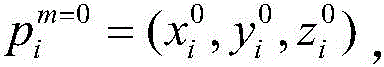
3.1)记录所有手机初始位置


其中n为触发的手机数;m为迭代的次数,即更新全局最优点和自身最优点的次数,初始时m=0。Among them, n is the number of mobile phones triggered; m is the number of iterations, that is, the number of times to update the global optimal point and its own optimal point, and initially m=0.
3.2)以手机初始点位置开始,随机一个三维速度进行迭代,让所有模拟点进行速度与位置更新,模拟点为三维点,是更新过程中的迭代点,其中,速度更新公式:3.2) Starting from the initial point position of the mobile phone, iterate with a random three-dimensional speed, and update the speed and position of all simulated points. The simulated point is a three-dimensional point, which is the iterative point in the update process. Among them, the speed update formula:

位置更新公式:Position update formula:
模拟点

直到模拟点更新后,满足评价函数,所述评价函数:Until the simulation point is updated, the evaluation function is satisfied, and the evaluation function is:
f(x)=S1-S2-ΔSi f(x)=S 1 -S 2 -ΔS i
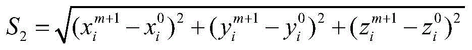
其中,S1为模拟点到台站的距离,S2为模拟点到手机初始点的距离Among them, S 1 is the distance from the simulated point to the station, and S 2 is the distance from the simulated point to the initial point of the mobile phone

其中:


当f(x)达到预设值,满足评价函数,证明已找到步骤2)中的双曲面;当f(x大于预设值时,说明模拟点还未找到步骤2)中的双曲面,ω不变;当f(x)小于预设值时,说明模拟点已经穿过步骤2)中的双曲面,令迭代速度方向取反,同时ω减小。When f(x) reaches the preset value and satisfies the evaluation function, it proves that the hyperboloid in step 2) has been found; when f(x) is greater than the preset value, it means that the simulation point has not found the hyperboloid in step 2), ω It does not change; when f(x) is less than the preset value, it means that the simulation point has passed through the hyperboloid in step 2), and the iterative velocity direction is reversed, and ω is reduced at the same time.
4)不断更新全局最优点和自身最优点;4) Constantly update the global optimum and its own optimum;
具体方法为:当95%的模拟点满足评价函数时,更新所有模拟点的自身最优点

5)确定震源点或震源范围;5) Determine the epicenter or the range of the epicenter;
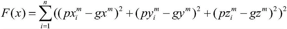
具体方法为:重复步骤3)、4)的迭代,使所有模拟点沿着双曲面向震源方向靠近,如图2所示,为固定台站和移动手机协同定位平面示意图,第一次计算的震源点为初始的全局最优点,图中五角星1点,随着迭代的进行,所有模拟点的更新,全局最优点也随之变化,经过m次对全局最优点的更新,所有模拟点到五角星m点距离的和F(x)满足小于一个定值ε时,终止迭代。The specific method is: repeating the iterations of steps 3) and 4) to make all the simulated points approach the source direction along the hyperboloid, as shown in Figure 2, which is a schematic diagram of the co-location of the fixed station and the mobile phone. The first calculated The source point is the initial global optimal point, and the five-pointed star is 1 point in the figure. As the iteration progresses, all simulation points are updated, and the global optimal point also changes. After m times of updating the global optimal point, all simulation points reach When the sum F(x) of the distances of the m points of the pentagram is less than a fixed value ε, the iteration is terminated.

其中,F(x)为目标函数,(gxm,gym,gzm)为全局最优点的位置,因为在每次迭代中,全局最优点为所有模拟点更新后位置的平均数,每次迭代对于所有模拟点来说,都只有一个全局最优点。ε为我们设定值即所有模拟点离全局最优点gbest的距离之和,当ε为0时,说明所有模拟点到全局最优点的距离全为0,即全部汇聚在全局最优点,则gbest点确定为震源点;当ε>0时,模拟点会汇聚在gbest点距离和为ε的空间范围内,可以确定震源附近的一个空间范围。Among them, F(x) is the objective function, (gx m , gy m , gz m ) is the position of the global optimal point, because in each iteration, the global optimal point is the average number of updated positions of all simulated points, and each time Iteration There is only one global optimum for all simulation points. ε is the value we set, that is, the sum of the distances from all simulated points to the global optimal point gbest. When ε is 0, it means that the distances from all simulated points to the global optimal point are all 0, that is, all converge in the global optimal point, then gbest The point is determined as the hypocenter point; when ε>0, the simulated points will converge in the space range of the distance from the gbest point and ε, and a spatial range near the hypocenter can be determined.
Claims (3)


Priority Applications (1)
| Application Number | Priority Date | Filing Date | Title |
|---|---|---|---|
| CN202010210919.9A CN111308552B (en) | 2020-03-24 | 2020-03-24 | A method for co-locating shock sources with low-density fixed stations and high-density mobile phones |
Applications Claiming Priority (1)
| Application Number | Priority Date | Filing Date | Title |
|---|---|---|---|
| CN202010210919.9A CN111308552B (en) | 2020-03-24 | 2020-03-24 | A method for co-locating shock sources with low-density fixed stations and high-density mobile phones |
Publications (2)
| Publication Number | Publication Date |
|---|---|
| CN111308552A CN111308552A (en) | 2020-06-19 |
| CN111308552B true CN111308552B (en) | 2022-07-19 |
Family
ID=71155395
Family Applications (1)
| Application Number | Title | Priority Date | Filing Date |
|---|---|---|---|
| CN202010210919.9A Active CN111308552B (en) | 2020-03-24 | 2020-03-24 | A method for co-locating shock sources with low-density fixed stations and high-density mobile phones |
Country Status (1)
| Country | Link |
|---|---|
| CN (1) | CN111308552B (en) |
Families Citing this family (1)
| Publication number | Priority date | Publication date | Assignee | Title |
|---|---|---|---|---|
| CN114047546B (en) * | 2021-11-18 | 2023-06-16 | 辽宁大学 | Crowd-sensing spiral ore vibration positioning method based on sensor three-dimensional space joint arrangement |
Citations (1)
| Publication number | Priority date | Publication date | Assignee | Title |
|---|---|---|---|---|
| CN107884822A (en) * | 2017-11-13 | 2018-04-06 | 北京矿冶研究总院 | Method for improving positioning precision of mining micro-seismic source |
Family Cites Families (6)
| Publication number | Priority date | Publication date | Assignee | Title |
|---|---|---|---|---|
| US8854219B2 (en) * | 2012-04-26 | 2014-10-07 | International Business Machines Corporation | System, method and program product for providing populace movement sensitive weather forecasts |
| US10133460B2 (en) * | 2014-03-26 | 2018-11-20 | Unanimous A.I., Inc. | Systems and methods for collaborative synchronous image selection |
| WO2017083556A1 (en) * | 2015-11-11 | 2017-05-18 | The Regents Of The University Of California | Myshake: smartphone-based earthquake early warning system |
| CN106982258B (en) * | 2017-04-06 | 2018-02-23 | 厦门帝嘉科技有限公司 | Earthquake early-warning system |
| CN109991658B (en) * | 2019-03-04 | 2021-02-05 | 成都理工大学 | A method for locating microseismic events based on the "source-station" velocity model |
| CN110650244A (en) * | 2019-09-24 | 2020-01-03 | 华东交通大学 | Intelligent mobile phone earthquake abnormal event detection method based on STA/LTA + DTW and intelligent mobile phone |
-
2020
- 2020-03-24 CN CN202010210919.9A patent/CN111308552B/en active Active
Patent Citations (1)
| Publication number | Priority date | Publication date | Assignee | Title |
|---|---|---|---|---|
| CN107884822A (en) * | 2017-11-13 | 2018-04-06 | 北京矿冶研究总院 | Method for improving positioning precision of mining micro-seismic source |
Also Published As
| Publication number | Publication date |
|---|---|
| CN111308552A (en) | 2020-06-19 |
Similar Documents
| Publication | Publication Date | Title |
|---|---|---|
| CN103605151B (en) | Based on the Distributed Cluster ripple shallow-layer microseism localization method of phase measurement | |
| CN107884822B (en) | Method for improving positioning precision of mining micro-seismic source | |
| CN103105624B (en) | Longitudinal and transversal wave time difference positioning method based on base data technology | |
| WO2022078514A1 (en) | Three-dimensional speed geological modeling method capable of random distribution of structures and wave speeds | |
| CN105785436B (en) | Mining micro-seismic monitoring method | |
| EA200601140A1 (en) | METHOD OF SEISMIC PROTECTION BUILDINGS IN COMPLEX GEOLOGICAL FORMATIONS | |
| CN105807316B (en) | Ground observation microseism velocity model corrections method based on amplitude superposition | |
| CN103389489B (en) | Micro earthquake monitoring and positioning method based on highly-deviated well | |
| CN108414983B (en) | A Microseismic Location Technology Based on Reverse Time Ray Tracing Method | |
| CN105842735A (en) | Complex-velocity-distribution regional rock micro-seismic seismic source positioning method | |
| CN110609321B (en) | Micro seismic source positioning method based on speed model database | |
| CN103105622B (en) | Based on the homotype ripple time difference positioning method of database technology | |
| Guidotti et al. | Numerical study on the role of basin geometry and kinematic seismic source in 3D ground motion simulation of the 22 February 2011 Mw 6.2 Christchurch earthquake | |
| CN112596106A (en) | Method for gravity-seismic joint inversion of density interface distribution in spherical coordinate system | |
| CN105549077B (en) | The microseism seismic source location method calculated based on multistage multiple dimensioned grid likeness coefficient | |
| CN111308552B (en) | A method for co-locating shock sources with low-density fixed stations and high-density mobile phones | |
| CN109444955A (en) | Interpolation method is disturbed when the bilinearity of three dimensional seismic raytracing is walked | |
| CN117313340B (en) | Intelligent design method for blasting scheme | |
| CN106443793A (en) | Space-time bivariant forward modeling method | |
| LaFehr | Gravity, isostasy, and crustal structure in the southern Cascade Range | |
| WO2021260563A3 (en) | System and method for subsurface structural interpretation | |
| Nazaruddin et al. | Intraplate earthquake occurrence and distribution in Peninsular Malaysia over the past 100 years | |
| CN114371493A (en) | A kind of satellite positioning point spatial position description and correction method, device and equipment | |
| WO2014040338A1 (en) | Method and device for obtaining optimization coefficient and for related wave field simulation | |
| CN120315031A (en) | A method and system for intelligent positioning of microseismic events |
Legal Events
| Date | Code | Title | Description |
|---|---|---|---|
| PB01 | Publication | ||
| PB01 | Publication | ||
| SE01 | Entry into force of request for substantive examination | ||
| SE01 | Entry into force of request for substantive examination | ||
| GR01 | Patent grant | ||
| GR01 | Patent grant |