CN109727255B - Building three-dimensional model segmentation method - Google Patents
Building three-dimensional model segmentation method Download PDFInfo
- Publication number
- CN109727255B CN109727255B CN201811444255.1A CN201811444255A CN109727255B CN 109727255 B CN109727255 B CN 109727255B CN 201811444255 A CN201811444255 A CN 201811444255A CN 109727255 B CN109727255 B CN 109727255B
- Authority
- CN
- China
- Prior art keywords
- electronic map
- building
- dimensional
- range
- vector data
- Prior art date
- Legal status (The legal status is an assumption and is not a legal conclusion. Google has not performed a legal analysis and makes no representation as to the accuracy of the status listed.)
- Active
Links
Images

Abstract
The invention aims to provide a building three-dimensional model segmentation method, which comprises the following steps: 1) Importing a two-dimensional electronic map into GIS software, and dividing the two-dimensional electronic map into electronic maps to be divided; 2) Converting the raster data of the electronic map to be divided into vector data, and merging to obtain merged vector data; 3) Coordinate correction is carried out on the fused vector data through GIS software, and boundary coordinates of each building to be segmented are obtained; 4) Acquiring a three-dimensional electronic map, matching each boundary coordinate with the three-dimensional electronic map, if buildings in the three-dimensional electronic map are all located in a range defined by the corresponding boundary coordinates, expanding each boundary coordinate to form a plurality of dividing lines, and otherwise, returning to the step 3); 5) And cutting the three-dimensional model falling into the range of each partition line through space analysis to finish the partition of the three-dimensional model of the building. The method overcomes the defects of the prior art, and has the characteristics of low cost, science, high efficiency and low technical difficulty.
Description
Technical Field
The invention relates to the field of computer graphics and geographic information science, in particular to a building three-dimensional model segmentation method.
Background
The live-action three-dimensional technology is increasingly popularized, but due to the technology, a live-action three-dimensional model is only a continuous three-dimensional surface skin, and a single building three-dimensional model is difficult to extract. In order to realize two-dimensional and three-dimensional linkage, some researchers propose to extract three-dimensional models such as buildings and the like by various methods or manually construct the part of models, and the mode is low in efficiency or high in realization cost. Later-period scholars try to cut building parts of the live-action three-dimensional model by using two-dimensional plane information of the large-scale topographic map, but the large-scale topographic map belongs to national secrets and is difficult to obtain by general production units, so that the application universality of the technical direction is limited.
Disclosure of Invention
The invention aims to provide a building three-dimensional model segmentation method, which overcomes the defects of the prior art and has the characteristics of low cost, science, high efficiency and low technical difficulty.
The technical scheme of the invention is as follows:
a building three-dimensional model segmentation method comprises the following steps:
1) Importing a two-dimensional electronic map containing a measuring area range in GIS software, and dividing the area of the measuring area range to be used as an electronic map to be divided;
2) Graying and vectorizing the electronic map to be segmented to obtain a vector data map of the segmented electronic map, inputting a gray value range corresponding to a building, filtering out pixel points of which the gray values are located in the gray value range in the vector data map, and fusing and merging adjacent pixel points to obtain a fused vector data map with gray areas of all buildings;
3) Coordinate correction is carried out on the fusion vector data through GIS software, boundary coordinates of each building to be segmented are obtained, and therefore the boundary range of each building to be segmented is obtained;
4) Acquiring a three-dimensional electronic map with the same coordinate system as the electronic map to be segmented, matching each boundary range with the three-dimensional electronic map, if buildings in the three-dimensional electronic map are all located in the corresponding boundary range, taking the boundary range as a segmentation line, and otherwise, returning to the step 3) to re-correct the boundary coordinates which do not meet the matching condition;
5) And cutting the three-dimensional model falling into the range of each parting line through space analysis to finish the building three-dimensional model segmentation.
Preferably, the two-dimensional electronic map including the survey area range is a two-dimensional electronic map without a label acquired on the internet, or boundary data issued by a supervisor part.
Preferably, the step 1) comprises the following steps:
11 Estimating the size of a two-dimensional electronic map containing a survey area range;
12 ) if the size exceeds 2000 x 2000 pixels, performing a slicing process according to the total number of pixels, wherein the size of each map is not larger than 2000 x 2000 pixels;
13 Obtaining each electronic map containing the obtaining range, wherein the maps are the electronic maps to be divided, and performing the operations of the steps 2) to 5) on each map.
Preferably, the step 2) is specifically:
21 Graying and vectorizing the electronic map to be segmented to obtain a vector data map of the segmented electronic map;
22 Selecting any one of the landmark buildings, obtaining a gray value range of the landmark building area, filtering the vector data image of the divided electronic map by using the gray value range, and obtaining a pixel of which the gray value is in the gray range;
23 Carrying out fusion and combination on the pixels obtained in the step 22) through a fusion function in spatial analysis to obtain a fused vector data diagram.
Preferably, the step 3) is specifically:
and selecting corner data of the corresponding building in the fused vector data to carry out coordinate correction of the four-parameter model, so as to obtain corrected vector data and boundary coordinates of the building to be segmented.
Preferably, the step 4) is specifically:
41 Obtaining a three-dimensional electronic map with the same coordinate system as the electronic map to be segmented, and superposing and matching the corrected vector data with the three-dimensional electronic map;
42 If the buildings in the three-dimensional electronic map are all located in the range defined by the corresponding boundary coordinates, expanding each boundary coordinate for 2 meters outwards to form a plurality of dividing lines, and entering step 5); otherwise, returning to the step 3) to re-correct the boundary coordinates which do not meet the matching condition.
Preferably, the three-dimensional electronic map is obtained by the following method:
acquiring a vertical image and an oblique image through oblique photography, performing on-site measurement on a ground control point to obtain a ground control point parameter, performing aerial triangulation by combining the vertical image, the oblique image and the ground control point parameter, then densely matching a digital earth surface model, then constructing a TIN model to obtain an initial model, and performing 3D texture mapping on the initial model to obtain a three-dimensional electronic map consisting of three-dimensional models.
Preferably, the GIS software is SuperMap5.3.3.
The building three-dimensional model segmentation method adopts the easily-obtained network two-dimensional electronic map to carry out preprocessing to obtain the vector data of the boundary range corresponding to the building, and then carries out the segmentation of the building model on the three-dimensional map, thereby greatly reducing the operation complexity and the segmentation time, simultaneously reducing the threshold and the cost of image acquisition, improving the application range of the method, and being applicable to small and medium-sized companies without basic geographic information data accumulation.
Drawings
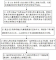
FIG. 1 is a schematic flow chart of a method for segmenting a three-dimensional model of a building according to the present invention;
fig. 2 is a schematic view of a partition line of the building three-dimensional model partition method provided in embodiment 1.
Detailed Description
The invention is explained in detail below with reference to the figures and examples.
Example 1
As shown in fig. 1-2, the method for segmenting a three-dimensional model of a building provided in this embodiment includes the following steps:
a building three-dimensional model segmentation method comprises the following steps:
1) Importing a two-dimensional electronic map containing a measuring area range in GIS software, and dividing the area of the measuring area range to be used as an electronic map to be divided;
the method specifically comprises the following steps: 11 Estimating the size of a two-dimensional electronic map containing a survey area range;
12 ) if the size exceeds 2000 x 2000 pixels, performing a slicing process according to the total number of pixels, wherein the size of each map is not larger than 2000 x 2000 pixels;
13 Obtaining each electronic map containing the obtaining range, wherein the maps are the electronic maps to be divided, and performing the operations of the steps 2) to 5) on each map;
2) Graying and vectorizing the electronic map to be segmented to obtain a vector data map of the segmented electronic map, inputting a gray value range corresponding to a building, filtering out pixel points of which the gray values are located in the gray value range in the vector data map, and fusing and merging adjacent pixel points to obtain a fused vector data map with gray areas of all buildings;
the method comprises the following specific steps: 21 Graying and vectorizing the electronic map to be segmented to obtain a vector data map of the segmented electronic map;
22 Selecting any one of the landmark buildings, obtaining a gray value range of a region of the landmark building, filtering the vector data map of the divided electronic map by using the gray value range, and obtaining a pixel of which the gray value is in the gray value range;
23 Carrying out fusion and combination on the pixels obtained in the step 22) through a fusion function in spatial analysis to obtain a fused vector data diagram;
3) Coordinate correction is carried out on the fusion vector data through GIS software to obtain boundary coordinates of each building to be segmented, and therefore the boundary range of each building to be segmented is obtained;
the method comprises the following specific steps: selecting corner point data of a corresponding building in the fused vector data to carry out coordinate correction of the four-parameter model, so as to obtain corrected vector data and boundary coordinates of the building to be segmented;
4) Acquiring a three-dimensional electronic map with the same coordinate system as the electronic map to be segmented, matching each boundary range with the three-dimensional electronic map, if buildings in the three-dimensional electronic map are all located in the corresponding boundary range, taking the boundary range as a segmentation line, and otherwise, returning to the step 3) to re-correct the boundary coordinates which do not meet the matching condition;
the method specifically comprises the following steps:
41 Obtaining a three-dimensional electronic map with the same coordinate system as the electronic map to be segmented, and superposing and matching the corrected vector data with the three-dimensional electronic map;
42 If the buildings in the three-dimensional electronic map are all located in the range defined by the corresponding boundary coordinates, expanding each boundary coordinate by 2 meters outwards to form a plurality of parting lines, and entering the step 5); otherwise, returning to the step 3) to re-correct the boundary coordinates which do not meet the matching condition;
5) And cutting the three-dimensional model falling into the range of each partition line through space analysis to finish the partition of the three-dimensional model of the building.
The two-dimensional electronic map containing the measuring area range is a two-dimensional electronic map without labels acquired on the Internet or boundary data issued by a supervisor part;
the three-dimensional electronic map is obtained by the following method: the method comprises the steps of collecting vertical images and oblique images through oblique photography, carrying out on-site measurement on ground control points to obtain ground control point parameters, combining the vertical images, the oblique images and the ground control point parameters, carrying out aerial triangulation, then densely matching digital earth surface models, then constructing a TIN model to obtain an initial model, carrying out 3D texture mapping on the initial model, and obtaining a three-dimensional electronic map formed by three-dimensional models.
The GIS software adopted in this embodiment is supermap5.3.3, the two-dimensional electronic map without tags adopted is a Google road network map without tags, and the two-dimensional electronic map selected in this embodiment is a map with a scale of 1:3000 to 1:15000 electronic map with resolution of 1.18 m; the corresponding gray scale range of the building is 0 to 255, and 2000 x 2000 pixels are arranged in the size of the electronic map to be divided; as shown in fig. 2, the method of the present embodiment can effectively divide the area of the building.
Claims (8)
1. A building three-dimensional model segmentation method is characterized by comprising the following steps:
1) Importing a two-dimensional electronic map containing a measuring area range in GIS software, and dividing the area of the measuring area range to be used as an electronic map to be divided;
2) Graying and vectorizing the electronic map to be segmented to obtain a vector data map of the segmented electronic map, inputting a gray value range corresponding to a building, filtering out pixel points of which the gray values are located in the gray value range in the vector data map, and fusing and merging adjacent pixel points to obtain a fused vector data map with gray areas of all buildings;
3) Coordinate correction is carried out on the fusion vector data through GIS software, boundary coordinates of each building to be segmented are obtained, and therefore the boundary range of each building to be segmented is obtained;
4) Acquiring a three-dimensional electronic map with the same coordinate system as the electronic map to be segmented, matching each boundary range with the three-dimensional electronic map, if buildings in the three-dimensional electronic map are all located in the corresponding boundary range, taking the boundary range as a segmentation line, and otherwise, returning to the step 3) to re-correct the boundary coordinates which do not meet the matching condition;
5) And cutting the three-dimensional model falling into the range of each partition line through space analysis to finish the partition of the three-dimensional model of the building.
2. The building three-dimensional model segmentation method according to claim 1, characterized in that: the two-dimensional electronic map containing the measuring area range is a two-dimensional electronic map without labels acquired on the Internet or boundary data issued by a main pipe part.
3. The building three-dimensional model segmentation method according to claim 1, characterized in that:
the step 1) comprises the following steps:
11 Estimating the size of a two-dimensional electronic map containing a survey area range;
12 ) if the size exceeds 2000 x 2000 pixels, performing a slicing process according to the total number of pixels, wherein the size of each map is not larger than 2000 x 2000 pixels;
13 Obtaining each electronic map containing the obtaining range, wherein the maps are the electronic maps to be divided, and performing the operations of the steps 2) to 5) on each map.
4. The building three-dimensional model segmentation method according to claim 1, wherein the step 2) is specifically as follows:
21 Graying and vectorizing the electronic map to be segmented to obtain a vector data map of the segmented electronic map;
22 Selecting any one of the landmark buildings, obtaining a gray value range of the landmark building area, filtering the vector data image of the divided electronic map by using the gray value range, and obtaining a pixel of which the gray value is in the gray range;
23 Carrying out fusion and combination on the pixels obtained in the step 22) through a fusion function in spatial analysis to obtain a fused vector data diagram.
5. The building three-dimensional model segmentation method according to claim 3, characterized in that: the step 3) is specifically as follows:
and selecting corner data of the corresponding building in the fused vector data to carry out coordinate correction of the four-parameter model, so as to obtain corrected vector data and boundary coordinates of the building to be segmented.
6. The building three-dimensional model segmentation method according to claim 4, characterized in that: the step 4) is specifically as follows:
41 Obtaining a three-dimensional electronic map with the same coordinate system as the electronic map to be segmented, and superposing and matching the corrected vector data with the three-dimensional electronic map;
42 If the buildings in the three-dimensional electronic map are all located in the range defined by the corresponding boundary coordinates, expanding each boundary coordinate for 2 meters outwards to form a plurality of dividing lines, and entering step 5); otherwise, returning to the step 3) to re-correct the boundary coordinates which do not meet the matching condition.
7. The building three-dimensional model segmentation method according to claim 1, characterized in that:
the three-dimensional electronic map is obtained by the following method:
acquiring a vertical image and an oblique image through oblique photography, performing on-site measurement on a ground control point to obtain a ground control point parameter, performing aerial triangulation by combining the vertical image, the oblique image and the ground control point parameter, then densely matching a digital earth surface model, then constructing a TIN model to obtain an initial model, and performing 3D texture mapping on the initial model to obtain a three-dimensional electronic map consisting of three-dimensional models.
8. The building three-dimensional model segmentation method according to claim 1, characterized in that: the GIS software is SuperMap5.3.3.
Priority Applications (1)
| Application Number | Priority Date | Filing Date | Title |
|---|---|---|---|
| CN201811444255.1A CN109727255B (en) | 2018-11-29 | 2018-11-29 | Building three-dimensional model segmentation method |
Applications Claiming Priority (1)
| Application Number | Priority Date | Filing Date | Title |
|---|---|---|---|
| CN201811444255.1A CN109727255B (en) | 2018-11-29 | 2018-11-29 | Building three-dimensional model segmentation method |
Publications (2)
| Publication Number | Publication Date |
|---|---|
| CN109727255A CN109727255A (en) | 2019-05-07 |
| CN109727255B true CN109727255B (en) | 2022-11-18 |
Family
ID=66294712
Family Applications (1)
| Application Number | Title | Priority Date | Filing Date |
|---|---|---|---|
| CN201811444255.1A Active CN109727255B (en) | 2018-11-29 | 2018-11-29 | Building three-dimensional model segmentation method |
Country Status (1)
| Country | Link |
|---|---|
| CN (1) | CN109727255B (en) |
Families Citing this family (3)
| Publication number | Priority date | Publication date | Assignee | Title |
|---|---|---|---|---|
| CN111273877B (en) * | 2019-12-31 | 2022-07-19 | 宝略科技(浙江)有限公司 | Linkage display platform and linkage method for live-action three-dimensional data and two-dimensional grid picture |
| CN113140022B (en) * | 2020-12-25 | 2022-11-11 | 杭州今奥信息科技股份有限公司 | Digital mapping method, system and computer readable storage medium |
| CN113822999B (en) * | 2021-09-22 | 2024-02-23 | 杭州趣村游文旅集团有限公司 | Building segmentation method of digital rural three-dimensional model |
Citations (5)
| Publication number | Priority date | Publication date | Assignee | Title |
|---|---|---|---|---|
| JP2000329552A (en) * | 1999-05-20 | 2000-11-30 | Gen Tec:Kk | Three-dimensional map preparing method |
| CN101290222A (en) * | 2008-06-13 | 2008-10-22 | 北京天下图数据技术有限公司 | Method for rapidly constructing three-dimensional architecture scene through real orthophotos |
| CN101872492A (en) * | 2010-06-09 | 2010-10-27 | 中国科学院深圳先进技术研究院 | Multi-angle map implementation method of three-dimensional simulation city |
| CN104318605A (en) * | 2014-10-23 | 2015-01-28 | 南京大学 | Parallel lamination rendering method of vector solid line and three-dimensional terrain |
| CN104658039A (en) * | 2015-02-12 | 2015-05-27 | 南京市测绘勘察研究院有限公司 | Urban digital map three-dimensional modeling manufacturing method |
-
2018
- 2018-11-29 CN CN201811444255.1A patent/CN109727255B/en active Active
Patent Citations (5)
| Publication number | Priority date | Publication date | Assignee | Title |
|---|---|---|---|---|
| JP2000329552A (en) * | 1999-05-20 | 2000-11-30 | Gen Tec:Kk | Three-dimensional map preparing method |
| CN101290222A (en) * | 2008-06-13 | 2008-10-22 | 北京天下图数据技术有限公司 | Method for rapidly constructing three-dimensional architecture scene through real orthophotos |
| CN101872492A (en) * | 2010-06-09 | 2010-10-27 | 中国科学院深圳先进技术研究院 | Multi-angle map implementation method of three-dimensional simulation city |
| CN104318605A (en) * | 2014-10-23 | 2015-01-28 | 南京大学 | Parallel lamination rendering method of vector solid line and three-dimensional terrain |
| CN104658039A (en) * | 2015-02-12 | 2015-05-27 | 南京市测绘勘察研究院有限公司 | Urban digital map three-dimensional modeling manufacturing method |
Non-Patent Citations (1)
| Title |
|---|
| 侧视地图中建筑物轮廓线提取的三维城市模型法;朱园媛等;《测绘学报》;20150915(第09期);全文 * |
Also Published As
| Publication number | Publication date |
|---|---|
| CN109727255A (en) | 2019-05-07 |
Similar Documents
| Publication | Publication Date | Title |
|---|---|---|
| CN110717983B (en) | Building elevation three-dimensional reconstruction method based on knapsack type three-dimensional laser point cloud data | |
| Cheng et al. | 3D building model reconstruction from multi-view aerial imagery and lidar data | |
| CN107767382A (en) | The extraction method and system of static three-dimensional map contour of building line | |
| EP2849117B1 (en) | Methods, apparatuses and computer program products for automatic, non-parametric, non-iterative three dimensional geographic modeling | |
| CN108921943B (en) | Road three-dimensional model modeling method based on lane-level high-precision map | |
| CN114612488A (en) | Building-integrated information extraction method, computer device, and storage medium | |
| CN109727255B (en) | Building three-dimensional model segmentation method | |
| CN110660125B (en) | Three-dimensional modeling device for power distribution network system | |
| CN115564926B (en) | Three-dimensional patch model construction method based on image building structure learning | |
| CN112990086A (en) | Remote sensing image building detection method and device and computer readable storage medium | |
| CN103839286B (en) | The true orthophoto of a kind of Object Semanteme constraint optimizes the method for sampling | |
| CN103871072A (en) | Method for automatic extraction of orthoimage embedding line based on projection digital elevation models | |
| CN104268941A (en) | Hot spot forming method and device for simulated three-dimensional map | |
| Wang et al. | A method for detecting windows from mobile LiDAR data | |
| CN116051980B (en) | Building identification method, system, electronic equipment and medium based on oblique photography | |
| CN109118576A (en) | Large scene three-dimensional reconstruction system and method for reconstructing based on BDS location-based service | |
| Habib et al. | Integration of lidar and airborne imagery for realistic visualization of 3d urban environments | |
| Nakagawa et al. | Panoramic rendering-based polygon extraction from indoor mobile LiDAR data | |
| CN112884026A (en) | Image recognition assisted power transmission line laser LiDAR point cloud classification method | |
| Yu et al. | A cue line based method for building modeling from LiDAR and satellite imagery | |
| Luo et al. | 3D building reconstruction from LIDAR data | |
| Carpanese et al. | Automated estimation of building height through image processing | |
| CN107292814B (en) | Digital mapping method and system in true three-dimensional environment by using Lidar data | |
| CN115828110B (en) | Water system space feature similarity detection method, device, storage medium and apparatus | |
| Hu et al. | A high-precision automatic extraction method for shedding diseases of painted cultural relics based on three-dimensional fine color model |
Legal Events
| Date | Code | Title | Description |
|---|---|---|---|
| PB01 | Publication | ||
| PB01 | Publication | ||
| SE01 | Entry into force of request for substantive examination | ||
| SE01 | Entry into force of request for substantive examination | ||
| GR01 | Patent grant | ||
| GR01 | Patent grant |