CN102483466A - Cdp electromagnetic marine data aquisition and processing - Google Patents
Cdp electromagnetic marine data aquisition and processing Download PDFInfo
- Publication number
- CN102483466A CN102483466A CN2010800377760A CN201080037776A CN102483466A CN 102483466 A CN102483466 A CN 102483466A CN 2010800377760 A CN2010800377760 A CN 2010800377760A CN 201080037776 A CN201080037776 A CN 201080037776A CN 102483466 A CN102483466 A CN 102483466A
- Authority
- CN
- China
- Prior art keywords
- data
- receiver
- transmitter
- cdp
- electromagnetic
- Prior art date
- Legal status (The legal status is an assumption and is not a legal conclusion. Google has not performed a legal analysis and makes no representation as to the accuracy of the status listed.)
- Pending
Links
Images

Classifications
-
- G—PHYSICS
- G01—MEASURING; TESTING
- G01V—GEOPHYSICS; GRAVITATIONAL MEASUREMENTS; DETECTING MASSES OR OBJECTS; TAGS
- G01V3/00—Electric or magnetic prospecting or detecting; Measuring magnetic field characteristics of the earth, e.g. declination, deviation
- G01V3/12—Electric or magnetic prospecting or detecting; Measuring magnetic field characteristics of the earth, e.g. declination, deviation operating with electromagnetic waves
-
- G—PHYSICS
- G01—MEASURING; TESTING
- G01V—GEOPHYSICS; GRAVITATIONAL MEASUREMENTS; DETECTING MASSES OR OBJECTS; TAGS
- G01V3/00—Electric or magnetic prospecting or detecting; Measuring magnetic field characteristics of the earth, e.g. declination, deviation
- G01V3/08—Electric or magnetic prospecting or detecting; Measuring magnetic field characteristics of the earth, e.g. declination, deviation operating with magnetic or electric fields produced or modified by objects or geological structures or by detecting devices
- G01V3/083—Controlled source electromagnetic [CSEM] surveying
Landscapes
- Physics & Mathematics (AREA)
- Engineering & Computer Science (AREA)
- Remote Sensing (AREA)
- Life Sciences & Earth Sciences (AREA)
- Electromagnetism (AREA)
- Geology (AREA)
- Environmental & Geological Engineering (AREA)
- General Life Sciences & Earth Sciences (AREA)
- General Physics & Mathematics (AREA)
- Geophysics (AREA)
- Geophysics And Detection Of Objects (AREA)
- Radar Systems Or Details Thereof (AREA)
- Water Treatment By Electricity Or Magnetism (AREA)
- Measurement Of Velocity Or Position Using Acoustic Or Ultrasonic Waves (AREA)
Abstract
A method and apparatus for the acquisition, processing and inversion of marine CSEM data are disclosed. According to the invention, the system provides data acquisition and processing of the responses measured simultaneously by multiple receivers placed in the near zone and partly in the intermediate zone at different distances around the transmitter.
Description
Method and apparatus with Yu Haiyang CSEM Data Acquisition, processing and conversion has been described.According to the present invention, this system provides by near region that is arranged in transmitter different distance place on every side and the data that part is arranged in the response that a plurality of receiver measured simultaneously in the mesozone and obtains and handle.
The conventional method of CSEM (Controlling Source electromagnetism) exploration is to accomplish through on the seabed, locating a plurality of electromagnetic recorders along straight line.Strong current source (transmitter) is positioned aboard ship, and current impulse is pushed in the cable that is immersed in the seawater and can generate an electromagnetic field, and this electromagnetic field has brought out the electromagnetic field in the submarine structure.The electromagnetic field that record is generated is to be used for later analysis.CSEM is at for example US 2003/0052685A (Eyring plucked instrument etc.; 2003), US 6628119B1 (Ai Desimu etc.; 2003), WO 02/14906A1 (Eyring plucked instrument etc., 2002), WO 03/034096A1 (hot Kazakhstan etc., 2003), WO 03/048812A1 (McGregor etc.; 2003) and among the WO 2007/053025 (Ba Ersukefu etc., 2007) be described.
The known problem of CSEM exploration is that the expectation electromagnetic signal of in submarine structure, responding to and the electromagnetic signal that is derived from earth magnetism vibrations, morning and evening tides, current, wind and surge and other internal signal of being produced by instrument (ADC (analog to digital converter), drift electrode etc.) and mobile transmitter and receiver cable are distinguished mutually.All these signals are all write down and are commonly referred to as " noise ".Be used to suppress the known technology so-called " stacking (stacking) " of noise.
This stacking technology comprises to be used long and measurement that repeat, and this has reduced the throughput rate of CSEM exploration.Simultaneously, this technology only is the situation energy minimization noise enough just of the random function of time at noise.Many times, noise source is not from relying on the source of time, for example, is derived from the inclination, current of local anomaly, the call wire of submarine topography etc.In these cases, in time stacking is otiose.
Yet, in these cases, can adopt the another kind of mode that suppresses noise, i.e. stacking in spatial domain.This method is called as common depth point (CDP) or is called as common midpoint (CMP) in some cases, and is widely used in the seismology.The basic design of CDP method is common lamella stacking (accumulation is with the average) wave reflection from the diverse location that is arranged in source and receiver.In addition, the border of its hypothetical layer tilt slightly (less than 3 the degree).Sand not (US 4430643) proposed this method is used for the processing of radar data in 1984.People such as Bei Luofu have confirmed CDP is handled the successful example of high-frequency electromagnetic (EM) data that are applied to GPR (GPR).
Yet seismology is on the one hand with high frequency E M depth measurement, have the different of principle with the CSEM depth measurement on the other hand.Radar carries out work (from 10MHz to 5MHz) with very high frequency range, and the EM field is corresponding to the ripple formula identical with the earthquake field.In this case, the CDP seismic technology can directly be used on the EM data.But in high like this frequency range, decay in the seawater of conduction with in the underground structure very apace in the EM field, therefore can not be used for the exploration of hydrocarbon.
Strack (US 0071709A1,2008) has proposed a kind ofly will be called as method that " common midpoint " EM data (CMP) and subsequently " conventional TEC time error correction (normal moveout correction) " add up as the seismology method.According to this method, all EM measurements all are recalculated into apparent resistivity and are averaged then.For the calculating of apparent resistivity, use the progressive and long distance (skew) in later stage, be actually direct current mode, and do not utilize transient state through big skew.Therefore, with regard to considering hydrocarbon, this probing has low spatial resolution.
People such as thomson (US 7502690B2,2009) have proposed the processing (t-CSEM technology) mainly as the t-CSEM data of geological data.He mentions, and in principle, the EM field of in the t-CSEM technology, using is different with the earthquake field, but still residual (it is not present in the diffusion EM field) of EM field analyzed in suggestion, then with data and some experience weights stacking mutually.Through adopting such restriction, result who receives and their resolution can not be to be detected.
The object of the invention is to correct or reduce at least one defective of prior art.
Characteristic specified realizes in instructions and the appended claims of this purpose through below.
The purpose of this invention is to provide the new and improved CSEM data capture method that is used to obtain about the quality data of the more big figure of subsea hydrocarbon structure.
Another object of the present invention provides new and improved CSEM disposal route, so that can suppress the noise that causes by the local earth magnetism heterogeneity in cross section, by instrument, current etc.
Another purpose of the present invention provides and suppresses new and improved CSEM method, and this method has the possibility that the processing of process that control data obtains and data is carried out simultaneously.
The present invention relates to be used for new method and the equipment that electromagnetism (EM) data are obtained, handled and change, be used to provide effective accumulation (stacking) of the EM response of the information that comprises underground structure (stratum) and electrical characteristics (resistivity).This information can come together to confirm whether hydrocarbon or water are arranged with earthquake, well logging and other geology and geophysical data in oil reservoir.
The new method that the present invention provides a kind of electromagnetic data of the CSEM of being used for probing to obtain.This method further is named as Controlling Source electromagnetism common depth point (CSEM CDP), and this method is based on the thought of the associating stacking of the response electromagnetic signal in time domain and the spatial domain, and its purpose is to minimize any noise and maximization signal to noise ratio (S/N ratio).
Preferably, two conditions are as the basis of CSEM CDP:
A) applied depth detecting method must operate in the time domain, and
B) landform and other stratum change near the depth measurement zone smoothly.
Preferably, along profile (profile) or before be identified as among a series of crowd that possibly comprise the subsea hydrocarbon oil reservoir and accomplish electromagnetic surveying.Each CDP crowd is made up of a plurality of receivers on the seabed that is mounted and is operated in the transmitter near region on every side.
Apply the current impulse with cliffy summit on the cable of transmitter in immersing seawater, receiver is then measured the EM response.
Preferably, all receiver all is positioned at transmitter different distances (skew) and locates; That is to say, enough far to avoid influencing IP (induced polarization) effect and enough closely to have the measurement acceptable signal-to-interference ratio.
Preferably, be stored in during the exploration all original electromagnetic datas, and said equipment carries out in real time in essence the processing and the conversion of the marine electromagnetic data of being stored according to operator's order by the receiver record.
Preferably; Change together between transmitter and the receiver around the transmitter apart from r (promptly satisfy the condition of near region---that is to say; Enough big enough decay and enough little consistent the registration) all data of locating to measure to provide EM to respond to be used for the IP effect; And the result of conversion relates to the center of circle of radius r, and the center of circle is CDP.
This process can be controlled through the measurement and the accumulation of data constantly, and if be necessary that the operator can install other receivers so that the acceptable result quality to be provided.
After the acceptable result in receiving a common depth point (CDP), transmitter and a plurality of receiver can be moved to along the next point in profile or zone.
In first aspect; The present invention relates more particularly to be used for the method for obtaining, handling and change to by the marine electromagnetic data that system write down; Said system is made up of the equipment of a plurality of synchronous workings; When electromagnetic field is installed in impulse generator on the boat deck when pumping into current impulse in the seawater and exciting; Said equipment is arranged to deposit electromagnetic field and is installed on the seabed or near the seabed, said marine electromagnetic data is common depth point (CDP) marine electromagnetic data, it is characterized in that; Said CDP marine electromagnetic data is to be in the data of electing in a plurality of raw data of the electromagnetic field that measures the time domain from the distance between transmitter and receiver (skew), and said distance meets the following conditions:
A) the CDP marine electromagnetic data only is made up of the power mode (galvanic mode) of electromagnetic field; And
B) all receivers all are positioned at the r that satisfies condition
1<r<r
2Distance (skew) locate r wherein
1Be the distance with transmitter, and compare with measured response signal in this distance induced polarization effects not obvious, and r
2Be the distance with transmitter, and compare still quite greatly in the response signal that this distance measures with noise that and receiver still is positioned at by condition
 In the near region of determined electromagnetic field.
Said process can comprise with respect to be present in that the resistivity of the layer in the earth and the vertical extent of said layer change said CDP electromagnetic data.
Said common depth point (CDP) electromagnetic data can be operated through the realization marine electromagnetic surveys that may further comprise the steps and obtain:
Transmitter is installed; This transmitter is identified as the polygonal center of the selected receiver pulsed emission current in seawater in the zone that possibly comprise the subsea hydrocarbon oil reservoir before be disposed in, a plurality of receivers that are used to deposit the electromagnetic field response simultaneously be installed in around the transmitter, satisfy above-mentioned condition a) and b) a distance;
Deposit and handle electromagnetic field response, show response and assess they whether satisfy above-mentioned condition a) and b); Do not satisfy in some or all of data under the situation of these conditions, change the position and the duplicate measurements of register;
Be that the resistivity on said stratum and the vertical extent on said stratum distribute initial parameters, to satisfy above-mentioned condition a) and b) all data of obtaining carry out associating conversions, and confirm the resistivity and the vertical extent on said stratum;
Repeat conversion with different initial models, and assess the thickness and the resistivity precision of the layer of being found;
The condition that satisfies the above-mentioned validity that is used for confirming common depth point (CDP) electromagnetic data a) and b) selected receiver polygon inner additional receiver is installed, and if the precision that is obtained do not meet the demands then obtain common depth point (CDP) electromagnetic data times without number;
Before be identified as in the zone that possibly contain the subsea hydrocarbon oil reservoir and transmitter and receiver moved to contiguous receiver polygon from current receiver polygon along specified profile, and repeat above-described institute in steps;
Before be identified as and repeat above-described all operations on the All Ranges that possibly contain the subsea hydrocarbon oil reservoir, connect all parts that (stitch) is made up of the resistivity and the vertical extent of said layer, and the visual constructed resistivity pattern of 3D.
In second aspect; The present invention relates more particularly to be used for the equipment that obtains, handles and change of marine electromagnetic data; It is characterized in that said marine electromagnetic data can be to be in common depth point (CDP) marine electromagnetic data of selecting in a plurality of electromagnetic field records that measure the time domain from the distance that satisfies following condition (skew) between transmitter and receiver:
A) the CDP marine electromagnetic data only is made up of the power mode of electromagnetic field; And
B) receiver is positioned at the r that satisfies condition
1<r<r
2Distance (skew) locate r wherein
1Be the distance with transmitter, and compare with measured response signal in this distance induced polarization effects not obvious, and r
2Be the distance with transmitter, and in this distance, the response signal that measures is compared still quite big with noise, and receiver still is positioned at the near region of the electromagnetic field that is produced by transmitter.
Said equipment can comprise:
Be used to store the device of operating the original electromagnetic data that receives from marine electromagnetic surveys;
Principal computer, this principal computer comprise the device that is used to accept operator's order and are used to receive from the data of the said device that is used to store raw data and with said operator's order and send the device of AP unit to raw data; And
AP unit, this AP unit are used for receiving said order and said raw data from said principal computer, and order according to said operator and to handle and to change said data, and the result is visual in fact in real time;
Yet, said operator order relate to satisfy according to above clauses and subclauses a) and b) the 3D of processing and conversion, constructed object module of selection, the CDP data of in time and space, accumulating of data of CDP condition visual, about the approval of constructed object module with continue to measure or change the judgement of necessity of the position of transmitter and receiver.
For the shortcoming of the existing method of the advantage of understanding the present invention and other and further purpose and characteristics, the method that proposed of the present invention better and the marine electromagnetic surveys that is used for hydrocarbon, please come the following description of this invention of reference with reference to accompanying drawing.
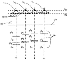
Fig. 1 has described on ground level, according to the scheme (Ba Ersukefu etc., 2007 years) of the technological common CSEM profile exploration of TEMP-VEL.The profile T of transmitter Tr
PProfile R with receiver Rz1, Rz2, Rz3 etc.
PBetween distance (skew) be r
1, and r
2The near region of EM field and the zone of mesozone have been confirmed;
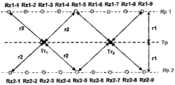
Fig. 2 has described part side view, partial plan (the profile T of transmitter and receiver of the simple embodiment of CSEM CDP array
P, R
P). Numeral 1,2,3,4 illustrates the position in 4 common depth point zones.Each zone comprises by along transmitter profile T
PThe location transmitter Tr and along receiver profile R
PThe crowd that 5 receiver Rz of location form.4 schematic sections are derived from 4 data sets, about the crowd's of 4 common depth points the conversion of uniting.
Fig. 3 has described on ground level, another example of CSEM CDP embodiment.Because along 2 profile R
P1 and R
PThe receiver of 2 installations is measured response signal simultaneously, so the efficient of exploration has increased.
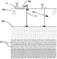
Fig. 4 shows the side view of common schematic device array.
In the accompanying drawings, Tr, Tr
1..., Tr
4Expression is used at seawater and comprises having different resistivity ρ
1, ρ
2, ρ
3, ρ
4The underground structure of one or more layers of Lb in the transmitter of induction field.Transmitter Tr, Tr
1..., Tr
4Be installed in the seawater Sw of the top that is arranged in seabed Sb, and carry out the signal communication (see figure 4) with signal generator Sg, signal generator Sg is disposed on the ship V on the ocean surface S.T
PExpression transmitter profile.
A plurality of receiver Rz, Rz1..., Rz9; Rz1-1..., Rz1-9; Rz2-1..., Rz2-9 is used to write down field intensity and signal value is delivered to the data storage device (not shown).R
P, R
P1 and R
P2 expression receiver profiles.
The principal computer (not shown) comprises and is used to accept the device of operator's order and be used to receive the device from the data of said data storage device.
AP unit (not shown) is used to receive said order and the said data from principal computer, and according to the said data of said operator's command conversion with carry out the result visual in real time basically.
Among Fig. 1 of the ground level of the emitter/receiver scheme in showing common CSEM profile exploration, r
1The profile T of expression transmitter Tr
PProfile R with receiver Rz1, Rz2, Rz3 etc.
PBetween distance (skew), and r
2The distance (skew) to the condition of the near region of EM field or mesozone is satisfied in definition.
In Fig. 3 of the ground level that shows the emitter/receiver scheme of surveying to CSEM CDP profile, Rz1-1..., Rz1-5, Rz2-1..., Rz2-5 represent the polygonal example of so-called receiver around the transmitter Tr1.The included receiver of receiver polygon showed satisfy the near region condition apart from r
2
As everyone knows, in order to increase signal to noise ratio (S/N ratio), adopt dual mode that the signal from electric field result's measurement is accumulated the accumulation on promptly temporal accumulation and the space.Temporal accumulation is easily for all existing CSEM methods.
Yet, be not that all existing CSEM methods that are used for the exploration of hydrocarbon marine electromagnetic can both be improved through spatial summation.This can be through being operated in the frequency domain and based on method (for example, SBL method (Eyring plucked instrument etc., 2003 of geometric sounding principle; Ai Desimu etc., 2002,2003; Greer etc., 2004; McGregor etc., 2000,2003,2004; Friend section etc., 2004; Wei Kelangde etc., 2004; Xin Ha etc., 2003 etc.) low spatial resolution explain that wherein, revise the ocean of this method well-known direct current probing method that to be C. Shi Lunbeigeer propose the twenties in 19th century.
Only when being applied to the transient electromagnetic method of operating with the power mode of the EM field in the near region, the accumulation on the space is only possible; For example, TEMP-VEL and TEMP-OEL method are only used the vertical component of electric field.
To being positioned at source (transmitter) Tr
1..., Tr
4N interior among a small circle receiver Rz1 on every side ..., the vertical component of the electric field among the RzN is measured simultaneously and on average can be increased and the factor
 Proportional signal to noise ratio (S/N ratio); Since these receivers Rz1 ..., the noise among the RzN is incoherent; This is because come the vertical component of the electric field of self noise mainly to be caused by local heterogeneity, for being positioned at not comprovincial all receivers, can not be identical therefore.
Yet, 2 restrictions are arranged, make and use directly on average cannot of signal.
The first, the induced signal that comprises about the useful information in cross section depends on the distance (skew) between transmitter and the receiver, therefore has different amplitude at the different distances place.
The second, this useful signal is complicated by induced polarization effects institute, and induced polarization effects has been covered signal and made the conversion of the data that obtain and explanation become difficult.
The problem of these restrictions can be resolved through the appropriate selection of distance (skew).Conditions must be fulfilled in desirable CDP zone (annulus) r
1<r<r
2, wherein, r
1Be the inside radius (skew) of ring, r
2It is external radius.Two radiuses can both find from following consideration.
Ultimate range (r
2The border) confirms by the end in the far field of EM field.In time domain, the border in far field takes place at time t place, wherein at its symbol of the time t EM of place signal change.Time t mainly depends on the electricalresistivity (up to~500) and the distance (skew) of sedimentogeneous rock:
 Ultimate range r
2Be selected, so that can be no less than t
MaxEffective conversion, wherein t are provided in the time range of/t>30
MaxIt is the maximum time (this time is confirmed by noise level) that signal is deposited.For example, if ρ=2 Ω m, t
Max=10s and t~0.3s, r<1.7km so.
Ultimate range r
2Be selected, so that can be no less than t
MaxEffective conversion, wherein t are provided in the time range of/t>30
MaxIt is the maximum time (this time is confirmed by noise level) that signal is deposited.For example, if ρ=2 Ω m, t
Max=10s and t~0.3s, r<1.7km so.
The IP effect is forced service range r>r
IPHere, r
IPBe in the enough little distance of its place's IP effect.For example, at IP~0.3% (background value) and ρ=2 Ω m places, apart from r
IP>1km provides at time t
MaxThe enough conditions in=10s place with IP distortion suppression to 30%.
Therefore, in our example, the CDP zone is positioned at the annulus of 1km<r<1.7km.
Spatial summation in the CDP method is realized by the method for the 1D conversion plan through using a plurality of transient processes simultaneously; That is to say, and be positioned at a r
1, r
2..., r
NIn the corresponding experimental Response Ez (r of receiver
1), Ez (r
2) ..., Ez (r
N) the certain minimization function of search of parameter of the branch layer cross section that is directed against
 Wherein, Rz
1, Rz
2..., Rz
NBe and the corresponding calculating of the model that is found back response.Last part provides the Tr-Rz to the crowd
1-Rz
2... public result.
Wherein, Rz
1, Rz
2..., Rz
NBe and the corresponding calculating of the model that is found back response.Last part provides the Tr-Rz to the crowd
1-Rz
2... public result.
The simplest profile scheme of transmitter shown in Figure 1 and receiver position can be used in the CSEM CDP exploration of using the TEMP-VEL/OEL method.In the phase one, the whole responses that measure at each some place are by stacking in time, and that kind as shown in Figure 2 then is apart from r
1<r<r
2In they are divided into groups and are used for 1D conversion.
Fig. 3 shows the senior geometric distortion of CDP method, two receiver profile Rp1 wherein, and Rp2 is used simultaneously.If be necessary to improve the precision of data, then can increase the number of receiver.
Can be used to produce through application and handle and conversion is measured the device that raw data obtains simultaneously and increased the efficient of exploration, and if be necessary that decision increases receiver and duplicate measurements.
Reference list
The United States Patent (USP) publication

Other patents
WO 0,2/1,490,6A1 02/2002 Eyring plucked instrument etc.
WO 03,/03,409,6A1 04/2003 hot Kazakhstan etc.
WO 03,/04,881,2A1 06/2003 McGregor etc.
WO/2007/053025 05/2007 Ba Ersukefu etc.
Other publications:
Bei Luofu A., Sa Boku G., this woods P. of crin, Pulse GPR research.http: //radio.rphf.spbstu.ru/a263/pulsepic.
Husky husband A.D. and Cox C.S; Nineteen eighty-two: Controlled Electromagnetic Sources for Measuring Electrical conductivity Beneath the Oceans 1.Forawrd Problem and Model Study. geophysics research magazine; 87; B7, the 5327-5338 page or leaf.
Husky husband A.D., Constable S.C., Margaret Edwards R.N.; 1991: Electrical Exploration Methods for the Seafloor. the 12nd chapter.Receive than accounting for editor, applied geophysics, v.2, geophysics, tesla, Oklahoma, 931-966 page or leaf are explored by society.
Qi Siman S.J., Margaret Edwards R.N., husky husband A.D.; 1987: On the theory of sea floor conductivity mapping using transient electromagnetic system. geophysics, V.52, N2,204-217 page or leaf.
Cox C.S., Constable S.C., husky husband A.D., weber S.C.; 1986:Controlled source electromagnetic sounding of the oceanic lithosphere. nature, 320, the 52-54 page or leaf Margaret Edwards R.N., Lip river L.K., moral lourie dust J.M.; 1981: On measuring the electrical conductivity of the oceanic crust by a modified magnetometric resistivity method: geophysics's research magazine.V.68,11609-11615 page or leaf.
Margaret Edwards R.N., husky husband A.D.; 1986: On the theory of a transient electric dipole-dipole method for mapping the conductivity of the sea floor. geophysics, V.51, the 984-987 page or leaf.
Ai Dengsimu T., Eyring plucked instrument S., McGregor L.M., Constable S., the hot M.C. that breathes out, Claes Johanson S.E., empty N. and I Si Tedao H.; 2002: Sea Bed Logging (SBL), a new method for remote and direct identification of hydrocarbon filled layers in deepwater areas. first arrival, March 20,144-152 page or leaf.
Greer A.A.., McGregor L.M., Weir R.; 2004: Remote mapping of hydrocarbon extent using marine Active Source EM sounding. the 66th EAGE meeting and exhibition, Paris, France ,-10 days on the 6th June in 2004.
Breathe out Bel E., A Sheer U., Oldenburg D.W.; 2002: Inversion of 3D time domain electromagnetic data using an all-at-once approach: the 72nd report that annual international conference is submitted: geophysics was explored by society.
Ao Waer R.N., Lip river L.K., moral lourie dust J.M.; 1981: On measuring the electrical conductivity of the oceanic crust by a modified magnetometric resistivity method: geophysics's research magazine, 86, the 11609-11615 pages or leaves.
Kaufman A.A. and Kai Le G.V.; Nineteen eighty-three: Frequency and transient soundings: Amsterdam, like to think only your scientific publication company, the 411-454 page or leaf.
McGregor L., the hot M. that breathes out; 2000: Use of marine controlled-source electromagnetic sounding for sub-basalt exploration. geophysics was explored, v.48, and the 1091-1106 page or leaf.
McGregor L., Tompkins M., dimension is heard R., buckle N., 2004: Marine active source EM sounding for hydrocarbon detection. the 66th EAGE meeting and exhibition, Paris, France ,-10 days on the 6th June in 2004.
Tompkins M., Weir R., McGregor L.; 2004: Sensitivity to hydrocarbon targets using marine active source EM sounding:Diffusive EM mapping method. the 66th EAGE meeting and exhibition; Paris; France ,-10 days on the 6th June in 2004.
Auspicious special D.A., this Cuzco A. and Huo Busi B.A., calendar year 2001: the 70th annual international conference of Hydrocarbon detection with a multichannel transient electromagnetic survey., geophysics is explored by society.
Wei Kelangde T.A. sends out to receive and holds S.; 2004: the ocean of Norway: the SBL case study.The 66th EAGE meeting and exhibition, Paris, France ,-10 days on the 6th June in 2004.
This Cuzco A., Huo Busi B., auspicious special D., 2002: First direct hydrocarbon detection and reservoir monitoring using transient electromagnetics. first arrival, V.20, No.4, pp.224-225.
Claims (5)
1. one kind is used to obtain, handle and changes the method by the marine electromagnetic data of system log (SYSLOG), and said system is by the equipment (Tr of a plurality of synchronous workings
1..., Tr
4, Rz1 ..., Rz9, Rz1-1 ..., Rz2-9) constitute, when electromagnetic field when being installed in impulse generator (Sg) on ship (V) deck and pumping into current impulse in the seawater (Sw) and excite, the equipment (Tr of said a plurality of synchronous workings
1..., Tr
4, Rz1 ..., Rz9; Rz1-1 ..., Rz2-9) be arranged to write down electromagnetic field and be installed in that seabed (Sb) is gone up or seabed (Sb) near; Said marine electromagnetic data is common depth point (CDP) marine electromagnetic data, it is characterized in that, said CDP marine electromagnetic data is at transmitter (Tr
1..., Tr
4) and receiver (Rz1 ..., Rz9; Rz1-1 ..., the data of selecting in a plurality of raw readings of the electromagnetic field that the distance (skew) between Rz2-9) (r) measures in time domain, said distance meets the following conditions:
A) the CDP marine electromagnetic data only is made up of the power mode of electromagnetic field; And
B) all receivers (Rz1 ..., Rz9; Rz1-1 ..., Rz2-9) all be positioned at the r that satisfies condition
1<r<r
2Distance (skew) (r), r wherein
1Be and said transmitter (Tr
1..., Tr
4) distance, at this apart from r
1Place's induced polarization effects is compared not obvious with measured response signal, and r
2Be and said transmitter (Tr
1..., Tr
4) distance, at this apart from r
2The response signal that the place measures is compared still quite big with noise, and receiver (Rz1 ..., Rz9; Rz1-1 ..., Rz2-9) still be positioned at by condition
 In the near region of the electromagnetic field of confirming.
2. method according to claim 1 is characterized in that, said processing comprises with respect to be present in that resistivity and the vertical extent of said stratum (Lb) on the stratum (Lb) of earth interior change said CDP electromagnetic data.
3. method according to claim 1 and 2 is characterized in that, the marine electromagnetic surveys that said common depth point (CDP) electromagnetic data may further comprise the steps through execution is operated and obtained:
Transmitter (Tr is installed
1, Tr
2), said transmitter (Tr
1, Tr
2) be identified as the zone that possibly comprise the subsea hydrocarbon oil reservoir before be arranged in the polygonal center of selected receiver at seawater (Sw) pulsed emission current; Be configured to deposit a plurality of receiver (Rz1 of electromagnetic field response simultaneously; ..., Rz9, Rz1-1; ..., Rz2-9) be installed in said transmitter (Tr
1, Tr
2) on every side possibly satisfy condition according to claim 2 a) and b) certain distance (r) locate;
Deposit and handle the response of electromagnetic field, show said response and assess they whether satisfy condition according to claim 1 a) and b); Do not satisfy in some or all of data under the situation of these conditions, revise said receiver (Rz1 ..., Rz9, Rz1-1 ..., position Rz2-9) and duplicate measurements;
For the vertical extent on the resistivity (ρ) on said stratum and said stratum distribute initial parameters, to satisfy condition according to claim 1 a) and b) all data of obtaining carry out the resistivity (ρ) and the said vertical extent of uniting conversion and confirming said stratum (Lb);
Initial model with different repeats said conversion, and assesses the thickness and the resistivity precision on the stratum of being found;
Condition according to claim 1 a) and b), confirm in the selected receiver polygon that the validity of common depth point (CDP) electromagnetic data is met additional receiver (Rzn-1 to be installed; ...; Rzn-9), and if the precision that is obtained do not meet the demands then obtain common depth point (CDP) electromagnetic data repeatedly;
(Tp is Rp) with said transmitter (Tr along extending to the appointment profile that is identified as before in the zone that possibly comprise the subsea hydrocarbon oil reservoir
1, Tr
2) and said receiver (Rz1 ..., Rz9, Rz1-1 ..., Rz2-9) move to contiguous receiver polygon, and repeat above-mentioned institute in steps from current receiver polygon;
Before be identified as and repeat above-described all operations on the All Ranges that possibly comprise the subsea hydrocarbon oil reservoir, connect all parts and the visual constructed resistivity models of 3D formed by the resistivity and the vertical extent on said stratum.
4. an equipment that is used to obtain, handle and change marine electromagnetic data is characterized in that, said marine electromagnetic data is from transmitter (Tr
1..., Tr
4) with receiver (Rz1 ..., Rz9, Rz1-1 ..., Rz1-9, Rz2-1 ..., common depth point (CDP) marine electromagnetic data of selecting during a plurality of electromagnetic fields that the distance (skew) between Rz2-9) (r) measures in time domain write down, said distance satisfies following condition:
A) the CDP marine electromagnetic data only is made up of the power mode of electromagnetic field; And
B) said receiver (Rz1 ..., Rz9, Rz1-1 ..., Rz1-9, Rz2-1 ..., Rz2-9) be positioned at the r that satisfies condition
1<r<r
2Distance (skew) (r), r wherein
1Be and said transmitter (Tr
1..., Tr
4) distance, at this apart from r
1Place's induced polarization effects is compared not obvious with measured response signal, and r
2Be and said transmitter (Tr
1..., Tr
4) distance, at this apart from r
2The response signal that the place measures is compared still quite big with noise, and said receiver ((Rz1 ..., Rz9, Rz1-1 ..., Rz1-9, Rz2-1 ..., Rz2-9) still be positioned at by said transmitter (Tr
1..., Tr
4) in the near region of the electromagnetic field that produces.
5. equipment according to claim 4 is characterized in that, this equipment comprises:
Be configured to store device from the original electromagnetic data of marine electromagnetic surveys operation reception;
Principal computer, this principal computer comprise and are configured to accept the device of operator's order and are configured to be configured to store the device reception data of raw data and raw data is ordered the device that is sent to the AP unit with said operator from said; And
AP unit, this AP unit are configured to receive said order and said raw data from said principal computer unit, and order according to said operator and to handle and to change said data, and visualization result in fact in real time;
Wherein said operator order relate to satisfy according to the clauses and subclauses of claim 4 a) and b) the 3D of processing and conversion, constructed object module of selection, the CDP data of in time and space, accumulating of data of CDP condition visual, about the approval of constructed object module with continue to measure or change said transmitter (Tr
1..., Tr
4) and said receiver ((Rz1 ..., Rz9, Rz1-1 ..., Rz1-9, Rz2-1 ..., the decision-making of position Rz2-9).
Applications Claiming Priority (5)
| Application Number | Priority Date | Filing Date | Title |
|---|---|---|---|
| NO20092699 | 2009-07-17 | ||
| NO20092699 | 2009-07-17 | ||
| NO20100945A NO331381B1 (en) | 2009-07-17 | 2010-06-29 | Data collection and data processing for electromagnetic marine CDP paints |
| NO20100945 | 2010-06-29 | ||
| PCT/NO2010/000281 WO2011008106A1 (en) | 2009-07-17 | 2010-07-12 | Cdp electromagnetic marine data aquisition and processing |
Publications (1)
| Publication Number | Publication Date |
|---|---|
| CN102483466A true CN102483466A (en) | 2012-05-30 |
Family
ID=43449560
Family Applications (1)
| Application Number | Title | Priority Date | Filing Date |
|---|---|---|---|
| CN2010800377760A Pending CN102483466A (en) | 2009-07-17 | 2010-07-12 | Cdp electromagnetic marine data aquisition and processing |
Country Status (8)
| Country | Link |
|---|---|
| US (1) | US20120191352A1 (en) |
| EP (1) | EP2454616A1 (en) |
| CN (1) | CN102483466A (en) |
| AU (1) | AU2010271595B2 (en) |
| IN (1) | IN2012DN01448A (en) |
| MX (1) | MX2012000720A (en) |
| NO (1) | NO331381B1 (en) |
| WO (1) | WO2011008106A1 (en) |
Cited By (3)
| Publication number | Priority date | Publication date | Assignee | Title |
|---|---|---|---|---|
| CN103310114A (en) * | 2013-06-27 | 2013-09-18 | 浙江大学 | Space synchronization method for ocean monitoring data |
| CN109061746A (en) * | 2018-09-12 | 2018-12-21 | 国家海洋局第海洋研究所 | A kind of satellite transmission marine magnetism detection device |
| CN110989019A (en) * | 2019-12-26 | 2020-04-10 | 中国科学院电工研究所 | Method for acquiring and processing magnetic characteristic in-situ detection data of seabed sediment |
Families Citing this family (7)
| Publication number | Priority date | Publication date | Assignee | Title |
|---|---|---|---|---|
| AU2013214446A1 (en) * | 2012-01-31 | 2014-05-22 | Siemens Aktiengesellschaft | Fault detection in subsea power cables |
| CN102809763B (en) * | 2012-08-10 | 2016-08-10 | 中国地质科学院地球物理地球化学勘查研究所 | Earth-free induced polarization measurement method and instrument |
| US20140058677A1 (en) * | 2012-08-23 | 2014-02-27 | Westerngeco, L.L.C. | Method for processing electromagnetic data |
| US9625600B2 (en) | 2012-12-04 | 2017-04-18 | Pgs Geophysical As | Systems and methods for removal of swell noise in marine electromagnetic surveys |
| US9274241B2 (en) * | 2013-03-14 | 2016-03-01 | Pgs Geophysical As | Method and system for suppressing swell-induced electromagnetic noise |
| US9651707B2 (en) * | 2013-06-28 | 2017-05-16 | Cgg Services Sas | Methods and systems for joint seismic and electromagnetic data recording |
| EP3156827A1 (en) * | 2015-10-15 | 2017-04-19 | Org Geo As | Method and apparatus for marine electrical exploration |
Citations (6)
| Publication number | Priority date | Publication date | Assignee | Title |
|---|---|---|---|---|
| EP1425612B1 (en) * | 2001-09-07 | 2006-02-15 | The University Court of the University of Edinburgh | Detection of subsurface resistivity contrasts with application to location of fluids |
| WO2006089269A2 (en) * | 2005-02-18 | 2006-08-24 | Bp Corporation North America Inc. | System and method for using time-distance characteristics in acquisition, processing and imaging of t-csem data |
| WO2007053025A1 (en) * | 2005-11-03 | 2007-05-10 | Advanced Hydrocarbon Mapping As | A method for hydrocarbon reservoir mapping and apparatus for use when performing the method |
| US20080071709A1 (en) * | 2006-08-22 | 2008-03-20 | Kjt Enterprises, Inc. | Fast 3D inversion of electromagnetic survey data using a trained neural network in the forward modeling branch |
| WO2008066389A1 (en) * | 2006-11-27 | 2008-06-05 | Advanced Hydrocarbon Mapping As | A method of mapping hydrocarbon reservoirs in shallow waters and also an apparatus for use when practising the method |
| US20090015262A1 (en) * | 2007-07-09 | 2009-01-15 | Strack Kurt M | Buoy-based marine electromagnetic signal acquisition system |
-
2010
- 2010-06-29 NO NO20100945A patent/NO331381B1/en not_active IP Right Cessation
- 2010-07-12 EP EP10800090A patent/EP2454616A1/en not_active Withdrawn
- 2010-07-12 IN IN1448DEN2012 patent/IN2012DN01448A/en unknown
- 2010-07-12 US US13/384,550 patent/US20120191352A1/en not_active Abandoned
- 2010-07-12 WO PCT/NO2010/000281 patent/WO2011008106A1/en active Application Filing
- 2010-07-12 CN CN2010800377760A patent/CN102483466A/en active Pending
- 2010-07-12 MX MX2012000720A patent/MX2012000720A/en active IP Right Grant
- 2010-07-12 AU AU2010271595A patent/AU2010271595B2/en not_active Expired - Fee Related
Patent Citations (7)
| Publication number | Priority date | Publication date | Assignee | Title |
|---|---|---|---|---|
| EP1425612B1 (en) * | 2001-09-07 | 2006-02-15 | The University Court of the University of Edinburgh | Detection of subsurface resistivity contrasts with application to location of fluids |
| WO2006089269A2 (en) * | 2005-02-18 | 2006-08-24 | Bp Corporation North America Inc. | System and method for using time-distance characteristics in acquisition, processing and imaging of t-csem data |
| WO2007053025A1 (en) * | 2005-11-03 | 2007-05-10 | Advanced Hydrocarbon Mapping As | A method for hydrocarbon reservoir mapping and apparatus for use when performing the method |
| CN101351726A (en) * | 2005-11-03 | 2009-01-21 | 先进烃绘制公司 | A method for hydrocarbon reservoir mapping and apparatus for use when performing the method |
| US20080071709A1 (en) * | 2006-08-22 | 2008-03-20 | Kjt Enterprises, Inc. | Fast 3D inversion of electromagnetic survey data using a trained neural network in the forward modeling branch |
| WO2008066389A1 (en) * | 2006-11-27 | 2008-06-05 | Advanced Hydrocarbon Mapping As | A method of mapping hydrocarbon reservoirs in shallow waters and also an apparatus for use when practising the method |
| US20090015262A1 (en) * | 2007-07-09 | 2009-01-15 | Strack Kurt M | Buoy-based marine electromagnetic signal acquisition system |
Cited By (4)
| Publication number | Priority date | Publication date | Assignee | Title |
|---|---|---|---|---|
| CN103310114A (en) * | 2013-06-27 | 2013-09-18 | 浙江大学 | Space synchronization method for ocean monitoring data |
| CN109061746A (en) * | 2018-09-12 | 2018-12-21 | 国家海洋局第海洋研究所 | A kind of satellite transmission marine magnetism detection device |
| CN109061746B (en) * | 2018-09-12 | 2023-08-22 | 国家海洋局第一海洋研究所 | Satellite transmission ocean magnetic force detection device |
| CN110989019A (en) * | 2019-12-26 | 2020-04-10 | 中国科学院电工研究所 | Method for acquiring and processing magnetic characteristic in-situ detection data of seabed sediment |
Also Published As
| Publication number | Publication date |
|---|---|
| AU2010271595B2 (en) | 2013-06-06 |
| AU2010271595A1 (en) | 2012-03-08 |
| MX2012000720A (en) | 2012-04-19 |
| IN2012DN01448A (en) | 2015-06-05 |
| WO2011008106A1 (en) | 2011-01-20 |
| US20120191352A1 (en) | 2012-07-26 |
| NO20100945A1 (en) | 2011-01-18 |
| EP2454616A1 (en) | 2012-05-23 |
| NO331381B1 (en) | 2011-12-12 |
Similar Documents
| Publication | Publication Date | Title |
|---|---|---|
| CN102483466A (en) | Cdp electromagnetic marine data aquisition and processing | |
| RU2335788C2 (en) | System and method of hydrocarbon deposit control of using adjustable electromagnetic transmitter | |
| US8030934B2 (en) | Method for hydrocarbon reservoir mapping and apparatus for use when performing the method | |
| CA2383931C (en) | Remote reservoir resistivity mapping | |
| US7203599B1 (en) | Method for acquiring transient electromagnetic survey data | |
| CA2654442C (en) | Method for acquiring and interpreting seismoelectric and electroseismic data | |
| USRE40321E1 (en) | Remote reservoir resistivity mapping | |
| US9507044B2 (en) | Systems and methods for remote electromagnetic exploration for mineral and energy resources using stationary long-range transmitters | |
| US20080136420A1 (en) | Systems and methods for measuring sea-bed resistivity | |
| BRPI0616231B1 (en) | METHODS FOR IMPROVING AN ELECTROMAGNETIC PROSPECTION WITH A CONTROLLED SOURCE OF A UNDERGROUND REGION AND TO PRODUCE HYDROCARBONS FROM A SUBTERRANEAN REGION | |
| US10024995B2 (en) | System and method for elevated source to borehole electromagnetic survey | |
| JP2000513809A (en) | Satellite Synchronized 3D Geomagnetic System | |
| MX2011009538A (en) | Method and apparatus for offshore hydrocarbon electromagnetic prospecting based on circulation of magnetic field derivative measurements. | |
| Mittet et al. | Inversion of SBL data acquired in shallow waters | |
| Brady et al. | Electromagnetic sounding for hydrocarbons | |
| KR101552261B1 (en) | Method and systme for modeling unconformity surface of strata in elastic wave prospecting signal | |
| RU2324956C2 (en) | Method of marine electrical exploration of oil and gas fields and system of equipment for its implementation | |
| WO2021041364A1 (en) | Method for removing the effect of near surface galvanic distortion in surface to borehole em measurements | |
| Evans et al. | Further Investigation of the Eel River Shelf Resistivity Structure | |
| Woolsey et al. | A remote station to monitor sea floor stability and gas hydrate outcrops in the Gulf of Mexico | |
| MX2008005594A (en) | A method for hydrocarbon reservoir mapping and apparatus for use when performing the method | |
| WO2008150748A1 (en) | Method for determining the absolute orientation of subsea electromagnetic sensor arrays |
Legal Events
| Date | Code | Title | Description |
|---|---|---|---|
| C06 | Publication | ||
| PB01 | Publication | ||
| C10 | Entry into substantive examination | ||
| SE01 | Entry into force of request for substantive examination | ||
| C02 | Deemed withdrawal of patent application after publication (patent law 2001) | ||
| WD01 | Invention patent application deemed withdrawn after publication |
Application publication date: 20120530 |