Background technology
Spatial analysis is the original intention that Geographic Information System (GIS) is created, and one of superimposed analysis analytical approach that to be it important, particularly the superimposed operation of polar plot interlayer is one of old and the most difficult problem.Although Chrisman et al. has delivered first method, be called as WHIRLPOOL (Dutton 1979), because the algorithm complex height is very difficult to reach the degree that can move.People face all the time " how at the superimposed calculating of point, line, surface and complex space geometric object; especially during the superimposed operation of ' face ' object or polygon diagram interlayer; how to reduce the complicacy of algorithm, the precision Three Difficult Issues after solving special case (hole occurring in special) and keeping the figure reconstruction.
For example: the superimposed analytical calculation of calculating distribution situation and the quantity of all kinds of land use patterns in certain administrative area, that is: the calculating of carrying out the polygonal intersecting and merging of two polar plot interlayers, difference and comprising, the land use pattern that counts in each administrative area polygon distributes and quantity.In the computation process, not only need two polar plot layer Polygonal Boundary find intersections, reconstruction has the new polygon of multiple attribute, and guarantees the geometric accuracy of superimposed analysis; Also need the attributive character in the statistical study polygon scope; In addition, need to handle relation of inclusion or appearance " hole " phenomenon that thereupon produces especially.
Wherein, the superimposed analysis of vector graphics in the figure layer, it is by search, differentiation to polygonal shape find intersection and multiple attribute in each regional two figure layer, determine whether to produce new polygon, or do not need the residue polygon is reclassified or classification, carry out new polygon and rebuild, constitute new polar plot layer; Then, for a figure layer content added up superimposed analysis, to formed new polygon in the superimposed analysis result, carry out recomputating and distributing of attribute.
Close in the analytic process in that polar plot is stacked, to ask intersecting and merging, difference be most crucial process to polygon in the order that polygon is superimposed and the two figure layers, wherein: correct, the suitable superimposed calculating of polygon, can play the effect of raising the efficiency to the superimposed analysis of two figure layers.Abroad, famous algorithm is to be proposed by Cyrus and Beck, and whether the dot product of its direction vector by judging straight-line segment and polygon limit method vector greater than 0, and all intersection points are divided into upper and lower two groups; Then, get minimum intersection point and the maximum intersection point that descends in the group in the group respectively, as the end points of line segment visible part.But the Cyrus-Beck algorithm only is applicable to the friendship of asking of convex polygon, and is then nonsensical for concave polygon.Meanwhile, only be applicable to convex polygon ask intersecting and merging, the difference algorithm also have Shamos algorithm and O ' Rourke algorithm.In recent years, M.Rivero also proposes a kind of algorithm that can handle any simple polygon, but it is theoretical complicated, causes its time complexity to reach 0 ((n+k) (m+k)), and wherein: n, m are respectively the polygonal limit of two input figure layers numbers, and k then is their number of hits.At home, also have many scholars to be engaged in the research in this field, but the great majority employing is asked friendship in twos to the polygonal limit of two figure layers, efficient is obviously very low; In addition, some algorithm even also need open two-dimensional array, this large-scale dataset that spatial analysis is faced for GIS obviously can not satisfy application demand.Wherein, scholars such as Xie Zhong, Xue Sheng propose two figure layer polygon are carried out the two superimposed analyses of recirculating, and clearly not only can duplicate polygon, lead to errors, and operational efficiency are also inevitable very low.In numerous researchs, only people's such as Liu Yong Kui, Yang Weifang, Du Shuan algorithm can be asked polygonal intersecting and merging, poor, and it is based on first polygonal all limits, successively second polygon is carried out the line clipping operation, to obtain the intersection point on all limits.Though, it has proposed a kind of new algorithm flow " wrong contact transformation method " for line clipping, improved the efficient of find intersection, but all replacement operator is carried out on second polygonal m summit successively for first polygonal n bar limit, only for polygonal line segment intersection, its complexity has been O (n * m).And this algorithm need re-construct polygonal chain respectively for asking polygonal intersecting and merging, poor, causes the work of repetition, has reduced counting yield.Simultaneously, it overlaps polygonal limit or treatment of special situation such as intersects at the place, summit is to adopt the skew vertex operations, not only reduced operating efficiency, also can lose the precision of figure, there is critical defect in this spatial analysis to the high polar plot interlayer of accuracy requirement.
In sum, in the prior art, do not have a kind of polar plot interlayer arbitrary polygon that is applicable to and ask intersecting and merging, difference and the high efficiency method that comprises and attribute configuration method.Do not have substantial breakthrough in the superimposed operation of polar plot interlayer and three big difficult point problems in the analysis.Therefore, propose a kind of polar plot interlayer arbitrary polygon that is applicable to and ask intersecting and merging, difference and the high efficiency method that comprises and attribute configuration method, to strengthening the significant and practical value of performance of GIS spatial analysis functions.
Summary of the invention
The object of the present invention is to provide a kind of method for quickly superposing polygon vector layers, to solve the deficiencies in the prior art, provide a kind of both be applicable to handle arbitrary polygon ask intersecting and merging, difference and relation of inclusion, can efficiently handle the stacked method of closing analysis of two polar plots again.
The technical solution used in the present invention is as follows:
The quick superimposed analytical approach of a kind of polar plot layer polygon, it may further comprise the steps:
A) two polar plot layer polygon (each polygon must be the planar object of sealing) are deposited in respectively among two chained list G1 and the G2, and be that each figure layer polygon distributes unique ID number, rule is: j polygon ID of i figure layer is i_j; Simultaneously, also need one of initialization as a result figure layer R for empty;
B) suppose that Pi is the polygon that reads among the G1, Q
iIt is the polygon that reads among the G2.From G1 and G2, read polygon respectively, each polygon Pi that will obtain from G1 and the polygon Q all G2
iCarry out analysis and judgement; Be empty until G1, then show finish with G2 in all polygonal analysis and distinguishings, and all deposited in as a result among the figure layer R, jump to the H step; Otherwise will constantly from G1, obtain polygon Pi, and from G1, delete;
C) in above-mentioned differentiation process, mainly be to the polygon classification, judge Q
iThe outsourcing rectangle whether with the outsourcing rectangle intersection of Pi.If satisfy formula (1), then represent Q
iCan not intersect with Pi, with this polygon Q
iDeposit among the polygon set M, otherwise it is crossing to express possibility, deposits among the polygon set N; (P
Outsourcing) .x
2<(Q
The i outsourcing) .x
1‖ (P
Outsourcing) .y
2<(Q
The i outsourcing) .y
1‖ (P
The i outsourcing) .x
1>(Q
The i outsourcing) .x
2‖ (P
Outsourcing) .y
1>(Q
The i outsourcing) .y
2(1)
D) subsequently, carry out polygon and ask friendship, as long as polygon set N is not empty, then adopt the flat scanning line algorithm (Fig. 2) based on the case point group that Pi and N are carried out find intersection; If N is empty, then Pi is directly deposited into as a result among the figure layer R rebound B step;
E) then, the beginning polygon is rebuild.Earlier the polygon intersection point of trying to achieve based on the flat scanning line algorithm of case point group among the step D being carried out---former line segment blocks, and produces the processing of new node and the new line segment of connection; And, carry out the angle ordering to being communicated with the associated limit of posterior nodal point, generate the side information chained list by putting in order of same node limit;
F) again according to minimum angle principle, deep search is obtained all legal polygons counterclockwise, comprises friendship P ∩ N, P and poor P-N, the N of N and the poor N-P of P of P and N, and redistributes ID for each new polygon;
G) P ∩ N and P-N are deposited in as a result among the figure layer R, N-P is deposited among the set M, upgrades the graph data of second figure layer G2, cover G2 with M, namely make and return step B by G2=M;
H) behind superimposed the finishing of two all polygon of figure layer, polygon update all as a result then, and be stored in as a result among the figure layer R.Then, all polygon diagram graphic data among the R being carried out statistics of attributes calculates and disposes;
I) return results figure layer R finishes computing.
As a kind of preferred version, among the step C, according to the outsourcing rectangle polygon among second figure layer G2 is classified, remove the polygon that can not intersect with first figure layer G1 polygon Pi fast.
As a kind of preferred version, among the step D, utilization is carried out the polygon find intersection based on the flat scanning line algorithm of case point group, and adopt balanced binary tree and pile contour level data structures (as Fig. 3), not only can increase substantially the efficient of find intersection, also record in the figure layer all plans and asked and hand over polygonal geometric position.
As a kind of preferred version, in the step e, ordering with the transverse axis angle is carried out on the associated limit of same new node, can further improve the polygonal efficient of back deep search again.
As a kind of preferred version, in the step e, including the edge direction information of former polygon P and N set by the newly-generated side information chained list of summit order, is positive dirction counterclockwise, be negative direction clockwise, for back generation intersecting and merging, difference and the primitive rule of determining to provide enforcement of relation such as comprise.
As a kind of preferred version, in step F, the polygon angle that obtains according to deep search and, can judge that search order is counterclockwise or clockwise.If angle and be-2 π then for counterclockwise polygon, belong to polygonal friendship or poor; If 2 π, then be clockwise, belong to polygonal and or comprise, solve the judgement of special polygon (hole) in the superimposed analysis.
As a kind of preferred version, in step F, to the polygon that searches counterclockwise, also the former polygon ID that need belong to according to the limit of every formation judges former which which polygon of figure layer that belong in this limit, then can carry out new ID to newly-generated polygon as a result and distribute, for example: new polygon belongs to i a polygon of figure layer and b polygonal friendship of j figure layer, then distributing ID is i_a_j_b, if theirs is poor, and allocation rule refer step a then.If there is the positive limit that belongs to P on the limit that new polygon constitutes, then this new polygon belongs to P; If there is the limit to belong to the marginal of P, then do not belong to P; In like manner, N be can judge whether to belong to, P ∩ N, P-N or N-P belonged to thereby can draw actually; Concrete criterion is: if new polygon has the limit to belong to the positive dirction limit of first figure layer

That is to say periphery sides, so new polygon belongs to first figure layer coverage; On the contrary, if there is the limit to belong to first polygonal opposite direction limit
The opposite direction limit of ring limit or periphery sides in also being, so new polygon does not belong to first figure layer coverage; In like manner, can judge whether this polygon belongs to second figure layer.If belong to two figure layer coverages simultaneously, then this polygon is their friendship P ∩ N; Do not belong to second if belong to first figure layer coverage, then this polygon is their poor P-N; Do not belong to first if belong to second figure layer coverage, then this polygon is their poor N-P.Judgment rule is as follows:
As a kind of preferred version, in step H, need carry out property calculation and configuration to each polygon among the R, specifically can be according to each the new polygonal ID in the R figure layer, confirm the attribute of distribution, for example: ID is i_j, and then this new polygon only has j polygonal attribute of i figure layer, can calculate and configuration attribute according to the operational symbol of two figure interlayers; If ID is i_a_j_b, then this new polygon has i a polygon of figure layer and b polygonal two kinds of attribute of j figure layer, then need be by in like manner calculating and dispose actual property value.
As further preferred version, described flat scanning line algorithm based on the case point group is:
D1) line segment is sorted out by character: if vertical, then only generate a point, be denoted as vertical point, otherwise be divided into left end point and right endpoint;
D2) these are pressed the horizontal ordinate ordering, and the point of identical horizontal ordinate is classified as one group, be called the case point group, and be its design data structure;
D3) from left to right take out every group of case point set successively, every group of case point pressed the order of left end point, vertical point, right endpoint, intersection point and carried out following operation:
D31) left end point: sweep trace is in the left end point position of certain bar line segment e1, then searches this case point group τ earlier and whether has right endpoint; If there is a right endpoint Q, and related line segment is e2, and clearly these two line segments are end to end, then only need the e2 that replace line segment e1 among the τ to get final product, and with neighbouring line segment intersection, delete the right endpoint Q in this group then; If there is not right endpoint, then according to the coordinate of current left end point, e1 is inserted into position suitable among the τ, and asks friendship to judge with neighbouring line segment;
D32) vertical point: the characteristic of vertical line is only relevant with the state of current scan line; Because previous step has been handled left end point, then the current line segment relevant with vertical line all existed among the τ; And τ is balanced binary tree, can obtain one group of line-segment sets by dichotomizing search, and the intersection point of they and current scan line is on the vertical line, namely finds out the condition that satisfies line-segment sets δ:
Current vertical line and δ middle conductor are asked friendship, and wherein: α is the current scan line position, and [y1, y2] is the ordinate scope of vertical line;
D33) right endpoint: handled have the left end point of same coordinate with current right endpoint after, the line segment e that current group of remaining right endpoint connects only needs delete from τ simply, and the original two adjacent lines sections up and down of e are intersected judgement;
D34) intersection point: take out two line segment e1, e2 of this intersection point association, exchange the position in τ, and ask friendship to judge with the neighbouring line segment of respectively making a fresh start.
Advantage of the present invention or effect are embodied in following aspect:
1, main innovation part of the present invention is: on (1) method: propose the flat scanning line algorithm based on the case point group, utilize it that polygon is asked friendship, and in conjunction with the polygonal intersecting and merging of the minimum counterclockwise deep search of angle principle of polygon, difference and relation of inclusion, make up new polygon.(2) on the optimization process flow: unnecessary flow process has been saved in journey design in the stacked interflow of two figure, as: friendship is asked on the limit to two polygon diagram layers in twos, and the repetition polygon, that is: polygon asks the interchange journey to judge separating situation fast by the outsourcing rectangle, has avoided unnecessary intersection process; The data structure of designed case point group can rationally, effectively be stored intermediate result, has not only optimized treatment effeciency, and has recorded polygonal exact position, makes it to obtain correct result.(3) on the versatility of method: it can comprise arbitrary polygon in the processing figure layer.In other words, can exist protruding, recessed in the polar plot layer and three kinds of polygonal situations of hole.In the analyzing and processing process, this method both need not concave polygon is decomposed, and also need not carry out the concavity inspection of window, and it is a kind of general-purpose algorithm of simple arbitrary polygon, and polygon protruding, recessed and that contain hole all is suitable for.
2, major advantage of the present invention is: (1) proposes based on case point flat scanning line algorithm, and uses it to ask polygon intersection point in the two figure layers, preserves limit and intersection point information with balanced binary tree again, makes to ask to hand over efficient to be optimized significantly; Combining minimum angle principle, search for new polygon counterclockwise, can correctly draw net result figure layer.(2) realized the optimization process flow of the superimposed analyses of two polar plot interlayer arbitrary polygons, not only can improve the work efficiency of lamination process, can solve also that polar plot is stacked to close special polygonal processing in the analytic process, and superimposed result also can not duplicate polygon; (3) this method does not have the special processing requirement to polygon character, is applicable to arbitrary polygon, and applicability is fine, can be adapted to that the polygon polar plot is stacked to close processing.(4) figure layer data preprocess method is simply effective.
Embodiment
The present invention is further detailed explanation below in conjunction with the drawings and specific embodiments.
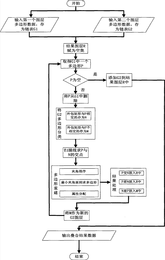
As shown in Figure 1:
Core process of the present invention is the polygonal superimposed order of polar plot layer, and asks the polygon intersection point based on the flat scanning line of case point group, according to the counterclockwise deep search of the minimum turning principle of polygon, the classification of carrying out polygonal intersecting and merging, difference and comprising.
Specifically, the quick folding method of polar plot layer polygon proposed by the invention, it can comprise arbitrary polygon in the processing figure layer, that is: figure can exist protruding, recessed and three kinds of polygonal situations of hole in the figure layer.In other words, this method both need not concave polygon is decomposed, and also need not carry out the concavity inspection of window, and it is a kind of general-purpose algorithm of simple arbitrary polygon, and polygon protruding, recessed and that contain hole all is suitable for.And the recessed and polygonal lamination process of hole is based on the lamination process of convex polygon, and when handling convex polygon figure layer, concrete analyzing and processing process comprises the steps: as shown in Figure 1
A, two figure layer polygon are deposited in respectively among two chained list G1 and the G2, and be that each figure layer polygon distributes unique ID number, rule is: an i figure layer j polygon ID is i_j; Initialization result figure layer R is empty;
B, if G1 be empty, then all polygons of G2 are deposited in as a result among the figure layer R, jump to h and go on foot; Otherwise from G1, obtain polygon, make up Pi outsourcing rectangle, and from G1, delete;
C, from G2, take out all polygon Q
i, judge Q
iThe outsourcing rectangle whether have crossing with the outsourcing rectangle of P.If formula (1) below satisfying is then represented Q
iCan not intersect with P, with this polygon Q
iDeposit among the polygon set M, otherwise it is crossing to express possibility, deposits among the polygon set N; (P
Outsourcing) x
2<(Q
The i outsourcing) x
1‖ (P
Outsourcing) y
2<(Q
The i outsourcing) y
1‖ (P
Outsourcing) x
1>(Q
The i outsourcing) x
2‖ (P
Outsourcing) y
1>(Q
The i outsourcing) y
2(1)
If d N is not empty, then P and N are carried out the flat scanning line find intersection of case point group; If N is empty, then P is directly deposited into as a result among the figure layer R, jump to the b step;
E, newly-generated intersection point is blocked former line segment, generate new line segment, and the angle ordering is carried out on associated limit, same summit, generate the information chained list on limit by the summit order;
F, according to minimum angle principle, deep search is obtained all legal polygons counterclockwise, comprises friendship P ∩ N, P and poor P-N, the N of N and the poor N-P of P of P and N;
G, P ∩ N and P-N are deposited in as a result among the figure layer R, N-P is deposited among the set M, upgrades the data of second figure layer G2, cover G2 with M, G2=M jumps to b and goes on foot;
H, recomputate and distributive property for the new polygon among the figure layer R as a result;
I, return results figure layer R finish.
In said method, the concrete operations of step a belong to initial work, import two figure layer data, save as G1, G2, and figure layer R as a result put sky.The polygonal periphery sides of regulation is input as counterclockwise input in this method, and the hole polygon is input clockwise, judges when making up new polygon for following step f that polygonal attaching information provides foundation.
Step b is the basic operation that first figure layer G1 carried out.Obtain first polygon object of superimposed analysis, and judge whether should process ends.If G1 is empty, get less than polygon, represent that then superimposed analysis finishes, be P otherwise preserve this polygon.
Step c is the operation that second figure layer carried out.Fundamental purpose is by judging P and Q
iThe outsourcing rectangle whether intersect, obtain the polygon Q that crossing possibility is arranged with first polygon P
i, and preserve among the polygon set N, avoid the polygon among all G2 is all asked friendship, improved efficient greatly.
In said method, steps d is core procedure of the present invention to the polygon find intersection.This method adopts flat scanning line algorithm based on the case point group in this flow process to the polygon find intersection.Classical scan-line algorithm generally is to ask many intersection points between the independent line segment, for this special line segment aggregate of polygon, a lot of end to end adjacent sides can appear, this is handled as intersecting in the flat scanning line algorithm of Bently and Ottmann proposition, need ask to hand over and judge, and it is preserved incoming event point sequence Ω as intersection point.In fact, two line segments are end to end not to belong to crossing, so need to change legacy data structure and algorithm flow, to avoid meaningless crossing judgement, improves counting yield.The present invention proposes the flat scanning line algorithm based on the case point group, and new scan-line algorithm flow process is summarized as the flow process among Fig. 3: 1. line segment is sorted out by character: if vertical, then only generate a point, be denoted as vertical point, otherwise be divided into left end point and right endpoint; 2. these are pressed the horizontal ordinate ordering, and the point of identical horizontal ordinate is classified as one group, be called the case point group, and be its design data structure; 3. from left to right take out every group of case point set successively, every group of case point pressed the order of left end point, vertical point, right endpoint, intersection point and carried out following operation:
1) left end point: sweep trace is in the left end point position of certain bar line segment e1, then searches this case point group τ earlier and whether has right endpoint; If there is a right endpoint Q, and related line segment is e2, and clearly these two line segments are end to end, then only need the e2 that replace line segment e1 among the τ to get final product, and with neighbouring line segment intersection, delete the right endpoint Q in this group then; If there is not right endpoint, then according to the coordinate of current left end point, e1 is inserted into position suitable among the τ, and asks friendship to judge with neighbouring line segment.
2) vertical point: the characteristic of vertical line is only relevant with the state of current scan line; Because previous step has been handled left end point, then the current line segment relevant with vertical line all existed among the τ; And τ is balanced binary tree, can obtain one group of line-segment sets by dichotomizing search, and the intersection point of they and current scan line is on the vertical line, namely finds out the condition that satisfies line-segment sets δ:
Current vertical line and δ middle conductor are asked friendship, and wherein: α is the current scan line position, and [y1, y2] is the ordinate scope of vertical line.
3) right endpoint: handled have the left end point of same coordinate with current right endpoint after, the line segment e that current group of remaining right endpoint connects only needs delete from τ simply, and the original two adjacent lines sections up and down of e are intersected judgement.
4) intersection point: take out two line segment e1, e2 of this intersection point association, exchange the position in τ, and ask friendship to judge with the neighbouring line segment of respectively making a fresh start.
The present invention uses the balanced binary tree algorithm instead and preserves line segment and intersection point information, and complexity has dropped to O ((n+m+k) log (n+m+k)) when making access line segment and intersection point, n wherein, and m is two polygonal limit numbers, k is two polygonal number of hits.The characteristic that intersects according to polygon, k m * n as can be known, efficient is greatly improved.In said method, step e is the intersection point that utilizes steps d to obtain, and the line segment that intersects is blocked, and generates new line segment.Its fundamental purpose is to do the data preparation for next step rebulids new polygon, and the angle ordering is carried out on newly-generated limit, makes things convenient for the deep search of back, improves search efficiency.
In said method, step f fundamental purpose is to rebulid new polygon.According to the relation between polygon limit and the limit, know that the angle that faces between the limit is counterclockwise minimum angle.So, adopt the limit after the e step sorts to angle during this flow process deep search polygon, search for polygon in order counterclockwise, and judge this polygonal attaching information according to the directivity on searching limit.
Specifically, the former polygon ID that can belong to according to the limit of every formation judges former which which polygon of figure layer that belong in this limit; And then can carry out new ID distribution and the calculating of attribute to newly-generated polygon as a result, for example: new polygon belongs to i a polygon of figure layer and a j figure layer b polygonal friendship, and then distributing new ID is i_a_j_b; Dispose new attribute subsequently, and according to the allocation rule of step h.If new polygon has the limit to belong to the positive dirction limit of first figure layer, that is to say periphery sides, so new polygon belongs to first figure layer coverage; On the contrary, if there is the limit to belong to first polygonal opposite direction limit, also be the opposite direction limit of interior ring limit or periphery sides, so new polygon does not belong to first figure layer coverage; In like manner, can judge whether this polygon belongs to second figure layer.If belong to two figure layer coverages simultaneously, then this polygon is their friendship P ∩ N; Do not belong to second if belong to first figure layer coverage, then this polygon is their poor P-N; Do not belong to first if belong to second figure layer coverage, then this polygon is their poor N-P.
Step g belongs to the transition flow process, and fundamental purpose is to preserve the superimposed analysis result of vector graphics of trying to achieve, and upgrades second figure layer data, prepares for carrying out superimposed circulation next time.
By above-mentioned steps b~g circulation, polygon is processed in figure layer one or figure layer two finishes, and another figure layer data is deposited into as a result among the figure layer R, jumps to step h.
At step h, then according to each new polygonal ID, for each new polygon is redistributed attribute: such as ID is i_j, then this new polygon only has j polygonal attribute of i figure layer; If ID is i_a_j_b, then this new polygon has i a polygon of figure layer and b polygonal two kinds of attribute of j figure layer; Therefore, according to the operational symbol of the superimposed calculating of two figure interlayers, for example: being sum operation between them, then calculating two polygonal attributes, is the new polygon of i_a_j_b to ID with new attribute configuration.
Step I: output is the figure layer as a result, process ends.
Above step can handle that general polygon diagram is stacked to be closed.The hole polygon is compared conventional polygon, many inside aperture polygons, and its periphery also is to belong to general polygon situation.According to above-mentioned steps b, peripheral polygon is by input counterclockwise, and the inside aperture polygon is by input clockwise; So the polygonal lamination process of hole is the same with conventional polygon, just need with above-mentioned flow processing once to suppose to have hole polygon A and B with peripheral polygon and inside aperture polygon are independent, the result satisfies following equation:
A ∩ B=(the peripheral polygon of the peripheral polygon ∩ of A. B.)-(A. hole ∪ B. hole)
A-B=((A. periphery-B. periphery) ∪ (the peripheral ∩ B. of A. hole))-A. hole
B-A=((B. periphery-A. periphery) ∪ (the peripheral ∩ A. of B. hole))-B. hole
In sum, the method for quickly superposing polygon vector layers that the present invention proposes, it is the method that the polygon in the two polar plot layers is asked intersecting and merging, difference and comprised.It adopts the flat scanning line algorithm based on case point that the polygon line segment is carried out find intersection; Then, block line segment by intersection point, generate new limit, and carry out the angle ordering; Then, use minimum angle principle, generate new polygon counterclockwise, and according to the polygonal attaching information of the determined property on limit.
In order to verify reliability of the present invention, we utilize the inventive method design and have formulated corresponding testing scheme and implementing procedure, and have gathered suitable experimental data for it and carried out the stacked experiment of closing analysis of two picture groups:
1, testing scheme
Testing scheme not only compares outside the analysis from point of theory analytical algorithm complexity, has also designed the testing scheme of algorithm comparative analysis.This scheme is selected than the superior in numerous documents---people's such as Liu Yongkui, Yang Weifang, Du Shuan algorithm, and the one, it belongs to similarly with algorithm of the present invention, can ask intersecting and merging, poor at least; The 2nd, the algorithm complex of this algorithm is better than existing other algorithms.
Simultaneously, testing scheme is that two algorithms have relatively been set up identical test environment, all adopts the java Programming with Pascal Language that is:, be integrated among the SVG WebGIS, and can be that the microcomputer of 1.99GHz moves in dominant frequency all.In order to make experimental result have more cogency, formulated two testing schemes:
Two polygons with N summit that generate four kinds of scale data volumes are at random adopted in experiment one, and they are asked the comprehensive computing of intersecting and merging, difference, obtain result's averaging time (unit is ms) of 1000 times, relatively the quality of two kinds of algorithms;
Experiment two, the settlement place of employing Guangzhou 1:1 ten thousand certain map sheets, circle, road He Zhen village isovector map layer data are as experimental data, data all adopt ArcGIS software to implement high-precision digitized processing flow process, and are treated as the E00 form through strict layer clean and topological relation; Because this method is integrated among the SVG WebGIS, express document, that is: the spatial information extension standards vector format of graphics standard SVG Network Based so be converted into SVG (Scalable Vector Graphics) spatial information standard again.Test uses two kinds of algorithms to a plurality of polygon (N1 in two figure layers of 4 groups of different scales, N2 is respectively separately polygonal the counting of figure layer) carry out superimposed analysis, not only carry out practicality and the validity test of method, and test is to the operation efficiency of practical sample.
2, interpretation
Fig. 4 provides the result who analyzes two kinds of method comparative analysiss from point of theory, can find that algorithm of the present invention possesses the advantage of two aspects: the one, algorithm of the present invention is behind unified definition data structure, the disposable polygonal intersecting and merging, poor of obtaining, avoided the repetition initialization step, save a lot of times, control methods is then asked in intersecting and merging, the difference process at polygon, needs construction data structure respectively; The 2nd, it is when the subordinate phase find intersection, need line clipping (asking friendship) is carried out on every limit of first polygon and second polygon, complexity is that (n * m), and the present invention adopts the flat scanning algorithm find intersection based on the case point group, complexity is reduced to O ((n+m+k) log (n+m+k)) to O.And, when two polygon find intersections, number of hits be generally k<<m+n, along with the increase that polygon is counted, this method superiority will be more outstanding.In order to compare the quality of two kinds of methods more intuitively, utilize MATLAB to draw find intersection complexity correlation curve figure (Fig. 4) earlier.Establish k=n=m among the figure, wherein horizontal ordinate is that polygon is counted; Ordinate is time complexity.The result shows, this method operation efficiency is counted to increase and presented clear superiority along with polygon.
The computing comparison consuming time of table 1 experiment one (unit: millisecond)
And then, analyze comparison according to two groups of result of experiment again.Result's (table 1) that experiment one experimentizes for the different scales polygon sequence that generates at random, it is consistent with theoretical analysis result to find to test its result, it is along with polygon is asked the growth of handing over number of times or data scale, and the advantage of this algorithm is more obvious, and has appeared the high efficiency of this algorithm suddenly.
The computing comparison consuming time (millisecond) of table 2 experiment two
The result of experiment two is as shown in table 2.It uses two kinds of algorithms that a plurality of polygons (N1, N2 are respectively polygonal the counting of figure layer separately) in two figure layers of 4 groups of different scales have been carried out superimposed analysis to experimental data.Experimental result: the one, verified that this paper method carries out practicality and the validity of superimposed analytical applications to diagram data practically; The 2nd, further proof is along with the increase of operational data amount, and its operation efficiency increases by geometric progression; The 3rd, provide the application example (Fig. 5,6) of the enlarging of road, housing demolition, Fig. 5 need in the mileage chart layer to have selected the road of enlarging earlier, supposes that these roads need extend 25 meters, then calculates 25 meters buffer zone; Then, this Fig. 5 and resident's point diagram interlayer are carried out superimposed analysis, red area then needs the removal house for enlarging among Fig. 6.
At present, the inventive method has been integrated in the SVG WebGIS system, obtains the effect of quick spatial analysis.Believe that along with further improvements in methods the method for inventing can further improve precision and the efficient of the superimposed analysis in space.