JP4741023B2 - Navigation device - Google Patents
Navigation device Download PDFInfo
- Publication number
- JP4741023B2 JP4741023B2 JP2009551327A JP2009551327A JP4741023B2 JP 4741023 B2 JP4741023 B2 JP 4741023B2 JP 2009551327 A JP2009551327 A JP 2009551327A JP 2009551327 A JP2009551327 A JP 2009551327A JP 4741023 B2 JP4741023 B2 JP 4741023B2
- Authority
- JP
- Japan
- Prior art keywords
- video
- last shot
- unit
- acquired
- vehicle
- Prior art date
- Legal status (The legal status is an assumption and is not a legal conclusion. Google has not performed a legal analysis and makes no representation as to the accuracy of the status listed.)
- Active
Links
- 238000003860 storage Methods 0.000 claims description 119
- 238000005259 measurement Methods 0.000 claims description 52
- 239000000203 mixture Substances 0.000 claims description 46
- 238000001514 detection method Methods 0.000 claims description 28
- 230000015572 biosynthetic process Effects 0.000 claims description 9
- 238000003786 synthesis reaction Methods 0.000 claims description 9
- 238000000034 method Methods 0.000 description 110
- 230000008569 process Effects 0.000 description 99
- 239000002131 composite material Substances 0.000 description 21
- 238000004364 calculation method Methods 0.000 description 14
- 238000010586 diagram Methods 0.000 description 8
- 230000009466 transformation Effects 0.000 description 8
- 230000004044 response Effects 0.000 description 6
- 238000004519 manufacturing process Methods 0.000 description 5
- 238000004321 preservation Methods 0.000 description 5
- 230000008859 change Effects 0.000 description 3
- 230000006866 deterioration Effects 0.000 description 2
- 102100035353 Cyclin-dependent kinase 2-associated protein 1 Human genes 0.000 description 1
- 238000013459 approach Methods 0.000 description 1
- 238000006243 chemical reaction Methods 0.000 description 1
- 230000000694 effects Effects 0.000 description 1
- 238000000605 extraction Methods 0.000 description 1
- 238000010191 image analysis Methods 0.000 description 1
- 238000003384 imaging method Methods 0.000 description 1
- 108090000237 interleukin-24 Proteins 0.000 description 1
- 239000004973 liquid crystal related substance Substances 0.000 description 1
- 230000007246 mechanism Effects 0.000 description 1
- 238000004904 shortening Methods 0.000 description 1
- 230000001502 supplementing effect Effects 0.000 description 1
Images


Classifications
-
- G—PHYSICS
- G01—MEASURING; TESTING
- G01C—MEASURING DISTANCES, LEVELS OR BEARINGS; SURVEYING; NAVIGATION; GYROSCOPIC INSTRUMENTS; PHOTOGRAMMETRY OR VIDEOGRAMMETRY
- G01C21/00—Navigation; Navigational instruments not provided for in groups G01C1/00 - G01C19/00
- G01C21/26—Navigation; Navigational instruments not provided for in groups G01C1/00 - G01C19/00 specially adapted for navigation in a road network
- G01C21/34—Route searching; Route guidance
- G01C21/36—Input/output arrangements for on-board computers
- G01C21/3626—Details of the output of route guidance instructions
- G01C21/3647—Guidance involving output of stored or live camera images or video streams
-
- G—PHYSICS
- G09—EDUCATION; CRYPTOGRAPHY; DISPLAY; ADVERTISING; SEALS
- G09B—EDUCATIONAL OR DEMONSTRATION APPLIANCES; APPLIANCES FOR TEACHING, OR COMMUNICATING WITH, THE BLIND, DEAF OR MUTE; MODELS; PLANETARIA; GLOBES; MAPS; DIAGRAMS
- G09B29/00—Maps; Plans; Charts; Diagrams, e.g. route diagram
- G09B29/003—Maps
Landscapes
- Engineering & Computer Science (AREA)
- Remote Sensing (AREA)
- Radar, Positioning & Navigation (AREA)
- Physics & Mathematics (AREA)
- Automation & Control Theory (AREA)
- General Physics & Mathematics (AREA)
- Theoretical Computer Science (AREA)
- Educational Administration (AREA)
- Educational Technology (AREA)
- Multimedia (AREA)
- Business, Economics & Management (AREA)
- Mathematical Physics (AREA)
- Navigation (AREA)
- Instructional Devices (AREA)
- Image Processing (AREA)
Description
この発明は、ユーザを目的地まで案内するナビゲーション装置に関し、特にカメラで撮影することにより得られた実写映像を用いて案内する技術に関する。 The present invention relates to a navigation apparatus that guides a user to a destination, and more particularly, to a technique for guiding using a photographed image obtained by photographing with a camera.
従来、カーナビゲーション装置において、走行中に車載カメラでリアルタイムに前方を撮影し、この撮影により得られた映像の上に、CG(Computer Graphics)によって案内情報を重畳して表示することにより経路誘導を行う技術が知られている(例えば、特許文献1参照)。 2. Description of the Related Art Conventionally, in a car navigation device, a front image is taken in real time with a vehicle-mounted camera while traveling, and route guidance is performed by superimposing and displaying guidance information by CG (Computer Graphics) on the image obtained by this photographing. The technique to perform is known (for example, refer patent document 1).
また、同様の技術として、特許文献2は、ナビゲーション情報要素を感覚的に把握しやすいように表示するカーナビゲーションシステムを開示している。このカーナビゲーションシステムは、自動車のノーズなどに取付けた撮像カメラで進行方向の景色を撮像し、ナビゲーション情報要素の背景表示について地図画像と実写映像とをセレクタで選択できるようにして、この背景画像に対して画像合成部によりナビゲーション情報要素を重ね合わせて表示器に表示する。この特許文献2には、実写映像を用いた交差点での経路誘導に関して、誘導する道路に沿ってのみ経路誘導矢印を表示する技術が開示されている。また、画像を解析せずに経路誘導矢印を重畳する方法として、実写映像と同じ視線角度および表示縮尺のCGから矢印を生成し、実写映像上に重畳する技術が開示されている。 Further, as a similar technique, Patent Document 2 discloses a car navigation system that displays navigation information elements so that the navigation information elements can be easily understood. This car navigation system captures a landscape in the direction of travel with an imaging camera attached to the nose of a car, and allows the selector to select a map image and a live-action video for the background display of navigation information elements. On the other hand, navigation information elements are overlaid by the image composition unit and displayed on the display. This patent document 2 discloses a technique for displaying a route guidance arrow only along a road to be guided with respect to route guidance at an intersection using a live-action image. In addition, as a method of superimposing a route guidance arrow without analyzing an image, a technique is disclosed in which an arrow is generated from a CG having the same line-of-sight angle and display scale as a live-action video and is superimposed on the live-action video.
上述した特許文献1および文献2に開示された技術では、リアルタイムに得られる映像を表示装置に表示して交差点経路誘導を行っているが、交差点に進入してから右左折を完了するまでは、運転者は運転操作に集中していることが多く、リアルタイムに得られる映像を表示装置に表示しても殆ど活用されない。また、交差点に進入している状況では、カメラの画角などに起因して、交差点の全貌がわかりにくい映像が表示されることが多いという問題がある。 In the techniques disclosed in Patent Document 1 and Document 2 described above, an image obtained in real time is displayed on a display device to perform an intersection route guidance, but from entering the intersection to completing a right / left turn, The driver is often concentrated on the driving operation, and even if the video obtained in real time is displayed on the display device, it is hardly utilized. In addition, in a situation where the vehicle is approaching an intersection, there is a problem that an image in which the entire image of the intersection is difficult to understand is often displayed due to the angle of view of the camera.
この発明は、上述した問題を解消するためになされたものであり、その課題は、例えば交差点といった案内対象物の近傍において、ユーザに適切な情報を提示できるナビゲーション装置を提供することにある。 The present invention has been made to solve the above-described problems, and an object thereof is to provide a navigation device that can present appropriate information to a user in the vicinity of a guidance object such as an intersection.
この発明に係るナビゲーション装置は、上記課題を解決するために、地図データを保持する地図データベースと、現在位置を計測する位置方位計測部と、自車の周囲の映像を取得する映像取得部と、位置方位計測部から取得した現在位置および地図データベースから取得した地図データに基づき計算した現在位置から案内対象物までの距離が一定距離以下になった場合に、その時点で映像取得部において取得された映像を固定して継続的に出力するラストショットモードに切り替えるべき旨を判断するラストショット判断部と、ラストショット判断部においてラストショットモードに切り替えるべき旨が判断された場合に、映像取得部で取得された映像をラストショット映像として保存する映像保存部と、映像保存部に保存されているラストショット映像を読み出し、該読み出したラストショット映像に、該ラストショット映像上に存在する案内対象物を説明するための図形、文字列またはイメージを含むコンテンツを重畳させて合成する映像合成処理部と、映像合成処理部で合成された映像を表示する表示部とを備え、ラストショット判断部は、一定距離を、案内対象物の大きさに応じて変化させている。 In order to solve the above problems, the navigation device according to the present invention includes a map database that holds map data, a position / orientation measurement unit that measures a current position, a video acquisition unit that acquires a video around the vehicle, When the distance from the current position calculated based on the current position acquired from the position and orientation measurement unit and the map data acquired from the map database to the guidance object is less than a certain distance, it was acquired at the video acquisition unit at that time Acquired by the video acquisition unit when it is determined that the last shot mode should be switched to the last shot mode, and the last shot mode is determined by the last shot determination unit. A video storage unit that stores the recorded video as a last shot video, and the last stored in the video storage unit A video composition processing unit that reads out the shot video and superimposes the content including a figure, a character string, or an image for explaining the guidance target object existing on the last shot video on the read last shot video; A display unit that displays the video synthesized by the video synthesis processing unit, and the last shot determination unit changes the certain distance according to the size of the guidance object .
また、地図データを保持する地図データベースと、現在位置を計測する位置方位計測部と、自車の周囲の映像を取得する映像取得部と、位置方位計測部から取得した現在位置および地図データベースから取得した地図データに基づき計算した現在位置から案内対象物までの距離が一定距離以下になった場合に、その時点で映像取得部において取得された映像を固定して継続的に出力するラストショットモードに切り替えるべき旨を判断するラストショット判断部と、ラストショット判断部においてラストショットモードに切り替えるべき旨が判断された場合に、映像取得部で取得された映像をラストショット映像として保存する映像保存部と、映像保存部に保存されているラストショット映像を読み出し、該読み出したラストショット映像に、該ラストショット映像上に存在する案内対象物を説明するための図形、文字列またはイメージを含むコンテンツを重畳させて合成する映像合成処理部と、映像合成処理部で合成された映像を表示する表示部とを備え、ラストショット判断部は、車線数、道路種別、道路の曲率または道路の曲がり具合の内の少なくとも1つに応じて一定距離を変化させている。 Also obtained from a map database that holds map data, a position / orientation measurement unit that measures the current position, a video acquisition unit that acquires images around the vehicle, and the current position and map database acquired from the position / orientation measurement unit When the distance from the current position calculated based on the map data to the guidance object is less than a certain distance, the last shot mode that fixes and continuously outputs the video acquired at the video acquisition unit at that time A last shot determination unit that determines that switching should be performed, and a video storage unit that stores the video acquired by the video acquisition unit as a last shot video when the last shot determination unit determines that the mode should be switched to the last shot mode. The last shot video stored in the video storage unit is read and the read last shot video is A video composition processing unit that superimposes a content including a figure, a character string, or an image for explaining a guidance object existing on the last shot video, and a display that displays the video synthesized by the video composition processing unit The last shot determination unit changes the fixed distance according to at least one of the number of lanes, the road type, the road curvature, or the road curvature .
また、地図データを保持する地図データベースと、現在位置を計測する位置方位計測部と、自車の周囲の映像を取得する映像取得部と、位置方位計測部から取得した現在位置および地図データベースから取得した地図データに基づき計算した現在位置から案内対象物までの距離が一定距離以下になった場合に、その時点で映像取得部において取得された映像を固定して継続的に出力するラストショットモードに切り替えるべき旨を判断するラストショット判断部と、ラストショット判断部においてラストショットモードに切り替えるべき旨が判断された場合に、映像取得部で取得された映像をラストショット映像として保存する映像保存部と、映像保存部に保存されているラストショット映像を読み出し、該読み出したラストショット映像に、該ラストショット映像上に存在する案内対象物を説明するための図形、文字列またはイメージを含むコンテンツを重畳させて合成する映像合成処理部と、映像合成処理部で合成された映像を表示する表示部とを備え、ラストショット判断部は、一定距離を、自己の移動速度に応じて変化させている。 Also obtained from a map database that holds map data, a position / orientation measurement unit that measures the current position, a video acquisition unit that acquires images around the vehicle, and the current position and map database acquired from the position / orientation measurement unit When the distance from the current position calculated based on the map data to the guidance object is less than a certain distance, the last shot mode that fixes and continuously outputs the video acquired at the video acquisition unit at that time A last shot determination unit that determines that switching should be performed, and a video storage unit that stores the video acquired by the video acquisition unit as a last shot video when the last shot determination unit determines that the mode should be switched to the last shot mode. The last shot video stored in the video storage unit is read and the read last shot video is A video composition processing unit that superimposes a content including a figure, a character string, or an image for explaining a guidance object existing on the last shot video, and a display that displays the video synthesized by the video composition processing unit The last shot determination unit changes the fixed distance according to its own moving speed.
また、地図データを保持する地図データベースと、現在位置を計測する位置方位計測部と、自車の周囲の映像を取得する映像取得部と、位置方位計測部から取得した現在位置および地図データベースから取得した地図データに基づき計算した現在位置から案内対象物までの距離が一定距離以下になった場合に、その時点で映像取得部において取得された映像を固定して継続的に出力するラストショットモードに切り替えるべき旨を判断するラストショット判断部と、ラストショット判断部においてラストショットモードに切り替えるべき旨が判断された場合に、映像取得部で取得された映像をラストショット映像として保存する映像保存部と、映像保存部に保存されているラストショット映像を読み出し、該読み出したラストショット映像に、該ラストショット映像上に存在する案内対象物を説明するための図形、文字列またはイメージを含むコンテンツを重畳させて合成する映像合成処理部と、映像合成処理部で合成された映像を表示する表示部とを備え、ラストショット判断部は、天候、昼夜、前方に車両が存在するか否か、または時間帯の内の少なくとも1つに応じて一定距離を変化させている。 Also obtained from a map database that holds map data, a position / orientation measurement unit that measures the current position, a video acquisition unit that acquires images around the vehicle, and the current position and map database acquired from the position / orientation measurement unit When the distance from the current position calculated based on the map data to the guidance object is less than a certain distance, the last shot mode that fixes and continuously outputs the video acquired at the video acquisition unit at that time A last shot determination unit that determines that switching should be performed, and a video storage unit that stores the video acquired by the video acquisition unit as a last shot video when the last shot determination unit determines that the mode should be switched to the last shot mode. The last shot video stored in the video storage unit is read and the read last shot video is A video composition processing unit that superimposes a content including a figure, a character string, or an image for explaining a guidance object existing on the last shot video, and a display that displays the video synthesized by the video composition processing unit The last shot determination unit changes the constant distance according to the weather, day and night, whether or not a vehicle is present ahead, or at least one of the time zones .
また、地図データを保持する地図データベースと、現在位置を計測する位置方位計測部と、自車の周囲の映像を取得する映像取得部と、位置方位計測部から取得した現在位置および地図データベースから取得した地図データに基づき計算した現在位置から案内対象物までの距離が一定距離以下になった場合に、その時点で映像取得部において取得された映像をラストショット映像として保存する映像保存部と、映像保存部から取得したラストショット映像の中に案内対象物が含まれているかどうかを検知する案内対象物検知部と、案内対象物検知部において案内対象物が含まれることが検知された場合に、映像取得部において取得された映像を固定して継続的に出力するラストショットモードに切り替えるべき旨を判断するラストショット判断部と、映像保存部に保存されているラストショット映像を読み出し、該読み出したラストショット映像に、該ラストショット映像上に存在する案内対象物を説明するための図形、文字列またはイメージを含むコンテンツを重畳させて合成する映像合成処理部と、映像合成処理部で合成された映像を表示する表示部とを備えている。Also obtained from a map database that holds map data, a position / orientation measurement unit that measures the current position, a video acquisition unit that acquires images around the vehicle, and the current position and map database acquired from the position / orientation measurement unit A video storage unit that stores the video acquired by the video acquisition unit at that time as a last shot video when the distance from the current position calculated based on the map data to the guidance object is less than a certain distance, and video When it is detected that the guidance target object is detected in the guidance target object detection unit and the guidance target object detection unit that detects whether the guidance target object is included in the last shot image acquired from the storage unit, The last shot size that determines whether or not to switch to the last shot mode where the video acquired by the video acquisition unit is fixed and output continuously. And a last shot video stored in the video storage unit, and the read last shot video includes a figure, a character string, or an image for explaining a guide object existing on the last shot video Are combined with each other, and a display unit for displaying the video synthesized by the video synthesis processing unit.
また、地図データを保持する地図データベースと、現在位置を計測する位置方位計測部と、自車の周囲の映像を取得する映像取得部と、自車が停車しているかどうかを判断する停車判断部と、位置方位計測部から取得した現在位置および地図データベースから取得した地図データに基づき計算した現在位置から案内対象物までの距離が一定距離以下になった場合に、その時点で映像取得部において取得された映像を固定して継続的に出力するラストショットモードに切り替えるべき旨を判断し、停車判断部によって停車していることが判断された場合に、ラストショットモードを解除するべき旨を判断するラストショット判断部と、ラストショット判断部においてラストショットモードに切り替えるべき旨が判断された場合に、映像取得部で取得された映像をラストショット映像として保存し、ラストショット判断部においてラストショットモードが解除するべき旨が判断された場合に、映像取得部で新たに取得された映像をそのまま送り出す映像保存部と、映像保存部に保存されているラストショット映像を読み出し、該読み出したラストショット映像に、該ラストショット映像上に存在する案内対象物を説明するための図形、文字列またはイメージを含むコンテンツを重畳させて合成し、映像保存部から送られてくる映像に、該映像上に存在する案内対象物を説明するためのコンテンツを重畳させて合成する映像合成処理部と、映像合成処理部で合成された映像を表示する表示部とを備えている。In addition, a map database that holds map data, a position / orientation measurement unit that measures the current position, a video acquisition unit that acquires video around the host vehicle, and a stop determination unit that determines whether the host vehicle is stopped And when the distance from the current position calculated based on the current position acquired from the position and orientation measurement unit and the map data acquired from the map database to the guidance object is less than a certain distance, acquired at that time by the video acquisition unit It is determined that the last shot mode should be switched to the last shot mode in which the recorded video is fixed and continuously output, and when it is determined that the vehicle is stopped by the stop determination unit, it is determined that the last shot mode should be cancelled. When the last shot determination unit and the last shot determination unit determine that the last shot mode should be switched, the video acquisition unit A video storage unit that stores the obtained video as a last shot video, and when the last shot determination unit determines that the last shot mode should be canceled, a video storage unit that sends out the video newly acquired by the video acquisition unit as it is, Reads the last shot video stored in the video storage unit, and superimposes the content including a figure, a character string, or an image for explaining the guidance object existing on the last shot video on the read last shot video The video composition processing unit that superimposes the content for explaining the guidance object existing on the video on the video sent from the video storage unit, and the video composition processing unit And a display unit for displaying video.
この発明に係るナビゲーション装置によれば、案内対象物から一定距離以下になった場合に、その時点における映像を固定して継続的に出力するラストショットモードに切り替えるように構成したので、例えば、案内対象物に近づきすぎて案内対象物が画面からはみ出てしまうといった、誘導に不適切な映像が表示されなくなるので表示が見やすくなり、例えば交差点といった案内対象物の近傍において、ユーザに好適な情報を提示できる。 According to the navigation device of the present invention, when the distance is less than a certain distance from the guidance object, the navigation device is configured to switch to the last shot mode in which the video at that time is fixed and continuously output. An image that is inappropriate for guidance is not displayed, such as the guidance object is too close to the object, and the display is easy to see. For example, information suitable for the user is presented near the guidance object such as an intersection. it can.
以下、この発明の実施の形態を、図面を参照しながら詳細に説明する。
実施の形態1.
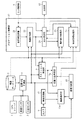
図1は、この発明の実施の形態1に係るナビゲーション装置の構成を示すブロック図である。なお、以下では、ナビゲーション装置の一例として、車両に搭載されるカーナビゲーション装置を例に挙げて説明する。ナビゲーション装置は、GPS(Global Positioning System)レシーバ1、車速センサ2、方位センサ3、位置方位計測部4、地図データベース5、ラストショット判断部6、位置方位保存部7、入力操作部8、カメラ9、映像取得部10、映像保存部11、ナビゲーション制御部12および表示部13を備えている。
Hereinafter, embodiments of the present invention will be described in detail with reference to the drawings.
Embodiment 1 FIG.
1 is a block diagram showing a configuration of a navigation apparatus according to Embodiment 1 of the present invention. In the following, a car navigation device mounted on a vehicle will be described as an example of the navigation device. The navigation device includes a GPS (Global Positioning System) receiver 1, a vehicle speed sensor 2, a direction sensor 3, a position / direction measurement unit 4, a map database 5, a last
GPSレシーバ1は、複数の衛星からの電波を受信することにより自車位置を計測する。このGPSレシーバ1で計測された自車位置は、自車位置信号として位置方位計測部4に送られる。車速センサ2は、自車の速度を逐次計測する。この車速センサ2は、一般には、タイヤの回転数を計測するセンサから構成されている。車速センサ2で計測された自車の速度は、車速信号として位置方位計測部4に送られる。方位センサ3は、自車の進行方向を逐次計測する。この方位センサ3で計測された自車の進行方位(以下、単に「方位」という)は、方位信号として位置方位計測部4に送られる。 The GPS receiver 1 measures its own vehicle position by receiving radio waves from a plurality of satellites. The own vehicle position measured by the GPS receiver 1 is sent to the position / orientation measurement unit 4 as an own vehicle position signal. The vehicle speed sensor 2 sequentially measures the speed of the own vehicle. The vehicle speed sensor 2 is generally composed of a sensor that measures the rotational speed of a tire. The speed of the host vehicle measured by the vehicle speed sensor 2 is sent to the position / orientation measurement unit 4 as a vehicle speed signal. The direction sensor 3 sequentially measures the traveling direction of the own vehicle. The traveling direction (hereinafter simply referred to as “direction”) of the host vehicle measured by the direction sensor 3 is sent to the position / direction measurement unit 4 as an direction signal.
位置方位計測部4は、GPSレシーバ1から送られてくる自車位置信号から自車の現在位置および方位を計測する。なお、トンネルの中または周囲の建物などによって自車の上空が遮られている場合は、電波を受信できる衛星の数がゼロまたは少なくなって受信状態が悪くなり、GPSレシーバ1からの自車位置信号だけでは自車の現在位置および方位が計測できなくなったり、計測できても精度が悪化したりするため、車速センサ2からの車速信号および方位センサ3からの方位信号を用いた自律航法を利用して自車位置を計測し、GPSレシーバ1による計測を補う処理を実行する。 The position / orientation measuring unit 4 measures the current position and direction of the own vehicle from the own vehicle position signal sent from the GPS receiver 1. In addition, when the sky of the own vehicle is blocked by a building in or around the tunnel, the number of satellites that can receive radio waves becomes zero or less, and the reception state deteriorates, and the position of the own vehicle from the GPS receiver 1 is deteriorated. Because it is impossible to measure the current position and direction of the vehicle with only the signal, or even if it can be measured, the accuracy deteriorates. Use autonomous navigation using the vehicle speed signal from the vehicle speed sensor 2 and the direction signal from the direction sensor 3 Then, the vehicle position is measured, and a process for supplementing the measurement by the GPS receiver 1 is executed.
位置方位計測部4で計測された自車の現在位置および方位は、上述したように、GPSレシーバ1の受信状態の悪化による計測精度の悪化、タイヤの摩耗による直径の変化、温度変化に起因する車速の誤差またはセンサ自体の精度に起因する誤差などといった様々な誤差を含んでいる。そこで、位置方位計測部4は、計測により得られた誤差を含んだ自車の現在位置および方位を、地図データベース5から読み出した地図データから取得した道路データを用いてマップマッチングを行うことにより修正する。この修正された自車の現在位置および方位は、自車位置方位データとしてラストショット判断部6、位置方位保存部7およびナビゲーション制御部12に送られる。
As described above, the current position and direction of the host vehicle measured by the position / orientation measurement unit 4 are caused by deterioration in measurement accuracy due to deterioration in the reception state of the GPS receiver 1, change in diameter due to tire wear, and temperature change. It includes various errors such as errors in vehicle speed or errors due to the accuracy of the sensor itself. Therefore, the position / orientation measurement unit 4 corrects the current position and direction of the vehicle including the error obtained by the measurement by performing map matching using road data acquired from the map data read from the map database 5. To do. The corrected current position and direction of the host vehicle are sent to the last
地図データベース5は、道路の位置、道路の種別(高速道路、有料道路、一般道路または細街路など)、道路に関する規制(速度制限または一方通行など)または交差点近傍のレーン情報といった道路データの他、道路周辺の施設のデータなどを含む地図データを保持している。道路の位置は、道路を複数のノードとノード間を直線で結ぶリンクとで表現され、このノードの緯度および経度を記録することにより表現されている。例えば、あるノードに3つ以上のリンクが接続されている場合は、そのノードの位置で複数の道路が交わっていることを表している。この地図データベース5に保持されている地図データは、上述したように位置方位計測部4によって読み出される他、ラストショット判断部6およびナビゲーション制御部12によって読み出される。
The map database 5 includes road data such as road location, road type (highway, toll road, general road, narrow street, etc.), road regulations (speed limit or one-way street, etc.) or lane information near intersections, It holds map data including data on facilities around roads. The position of the road is expressed by a plurality of nodes and links connecting the nodes with straight lines, and is expressed by recording the latitude and longitude of this node. For example, when three or more links are connected to a certain node, it indicates that a plurality of roads intersect at the position of the node. The map data stored in the map database 5 is read by the position / orientation measurement unit 4 as described above, and is read by the last
ラストショット判断部6は、ナビゲーション制御部12から送られてくる誘導経路データ(詳細は後述する)、位置方位計測部4から送られてくる自車位置方位データ、および、地図データベース5から取得した地図データを用いて、ラストショットモードに切り替えるべきかどうかを判断する。ここで、ラストショットモードとは、現在位置から案内対象物までの距離が一定距離以下になった時点の映像を固定し、ラストショット映像として継続的に出力することにより、ユーザに案内を提示する動作モードをいう。なお、ラストショット映像としては、厳密な意味で、現在位置から案内対象物までの距離が一定距離以下になった時点の映像に限定される必要はなく、その時点の前後の映像であって、案内対象物が中心に存在する映像または前方の景色が鮮明な映像などを用いることができる。
The last
ラストショット判断部6は、ラストショットモードに切り替えるべき旨を判断した場合は、ラストショットモードをONにし、そうでない場合はOFFにして、ラストショットモード信号として位置方位保存部7および映像保存部11に送る。このラストショット判断部6において実行される処理については、後に、さらに詳細に説明する。
When it is determined that the last shot mode should be switched, the last
位置方位保存部7は、ラストショット判断部6から受け取ったラストショットモード信号が、ラストショットモードのONを表しているときに、その時点で位置方位計測部4から送られてきている自車位置方位データを保存する。また、位置方位保存部7は、ラストショット判断部6から受け取ったラストショットモード信号が、ラストショットモードのOFFを表しているときに、保存している自車位置方位データを破棄する。さらに、位置方位保存部7は、ナビゲーション制御部12から位置方位取得要求を受け取った時に、自車位置方位データを保存していれば、その保存している自車位置方位データをナビゲーション制御部12に送り、自車位置方位データを保存していなければ、位置方位計測部4から自車位置方位データを取得し、ナビゲーション制御部12に送る。この位置方位保存部7で実行される処理については、後に、さらに詳細に説明する。
When the last shot mode signal received from the last
入力操作部8は、リモートコントローラ、タッチパネルまたは音声認識装置などの少なくとも1つから構成されており、ユーザである運転者または同乗者が、操作によって、目的地を入力したり、ナビゲーション装置が提供する情報を選択したりするために使用される。この入力操作部8の操作によって発生されたデータは、操作データとしてナビゲーション制御部12に送られる。
The
カメラ9は、自車の前方を撮影するカメラまたは周囲全体を含む幅広い方向を一度に撮影できるカメラなどの少なくとも1つから構成されており、自車の進行方向を含む自車近傍を撮影する。このカメラ9で撮影することにより得られた映像信号は、映像取得部10に送られる。
The
映像取得部10は、カメラ9から送られてくる映像信号を、計算機で処理可能なデジタル信号に変換する。この映像取得部10における変換により得られたデジタル信号は、映像データとして映像保存部11に送られる。
The
映像保存部11は、ラストショット判断部6から受け取ったラストショットモード信号が、ラストショットモードのONを表しているときに、その時点で映像取得部10から送られてきている映像データを取得して保存する。また、映像保存部11は、ラストショット判断部6から送られてくるラストショットモード信号が、ラストショットモードのOFFを表しているときに、保存している映像データを破棄する。さらに、映像保存部11は、ナビゲーション制御部12から映像取得要求を受け取った時に、映像データを保存していれば、その保存している映像データをナビゲーション制御部12に送り、映像データを保存していなければ、映像取得部10から映像データを取得し、ナビゲーション制御部12に送る。この映像保存部11で行われる処理については、後に、さらに詳細に説明する。
When the last shot mode signal received from the last
ナビゲーション制御部12は、入力操作部8から入力された目的地までの誘導経路の計算、誘導経路と自車の現在位置および方位とに応じた案内情報の生成、または、自車位置周辺の地図と自車位置を示す自車マークを合成した案内図の生成などといったナビゲーション装置が有する自車周辺の地図を表示する機能、および、自車を目的地に誘導するための機能などを提供するためのデータ処理を行う他、自車位置、目的地または誘導経路に関連する交通情報、観光地、飲食店または物販店などの情報の検索、入力操作部8から入力された条件にマッチした施設の検索といったデータ処理を実行する。
The
また、ナビゲーション制御部12は、地図データベース5から読み出した地図データに基づき生成した地図、映像取得部10から取得した映像データによって示される映像または自己の内部の映像合成処理部24(詳細は後述する)で合成された画像を、単独で、または、これらを組み合わせて表示するための表示データを生成する。このナビゲーション制御部12の詳細は後述する。ナビゲーション制御部12における種々の処理によって生成された表示データは、表示部13に送られる。
The
表示部13は、例えばLCD(Liquid Crystal Display)から構成されており、ナビゲーション制御部12から送られてくる表示データにしたがって、地図および/または実写映像などを画面に表示する。
The
次に、ナビゲーション制御部12の詳細を説明する。ナビゲーション制御部12は、目的地設定部21、経路計算部22、案内表示生成部23、映像合成処理部24および表示決定部25を備えている。なお、図1においては、図面の煩雑さを避けるために、上記複数の構成要素間の接続の一部を省略しているが、省略した部分については、以下において出現する都度説明する。
Next, details of the
目的地設定部21は、入力操作部8から送られてくる操作データにしたがって目的地を設定する。この目的地設定部21で設定された目的地は、目的地データとして経路計算部22に送られる。経路計算部22は、目的地設定部21から送られてくる目的地データ、位置方位計測部4から送られてくる自車位置方位データ、および、地図データベース5から読み出した地図データを用いて、目的地までの誘導経路を計算する。この経路計算部22で計算された誘導経路は、誘導経路データとしてラストショット判断部6および表示決定部25に送られる。
The
案内表示生成部23は、表示決定部25からの指示に応じて、従来のカーナビゲーション装置で用いられている地図による案内図(以下、「地図案内図」という)を生成する。この案内表示生成部23で生成される地図案内図には、平面地図、交差点拡大図、高速略図などといった実写映像を用いない様々な案内図が含まれる。また、地図案内図は、平面地図に限定されず、3次元CGを用いた案内図または平面地図を俯瞰する案内図であってもよい。なお、地図案内図を作成する技術は周知であるので、ここでは詳細な説明は省略する。この案内表示生成部23で生成された地図案内図は、地図案内図データとして表示決定部25に送られる。
In response to an instruction from the
映像合成処理部24は、表示決定部25からの指示に応じて、実写映像を用いた案内図(以下、「実写案内図」という)を生成する。例えば、映像合成処理部24は、地図データベース5から読み出した地図データから、誘導する経路、自車周辺の道路ネットワーク、ランドマークまたは交差点などといったナビゲーション装置で案内される全てのもの(以下、「案内対象物」と総称する)の情報を取得し、映像取得部10から送られてくる映像データによって示される実写映像の案内対象物の周辺に、この案内対象物の形状または内容などを説明するための図形、文字列またはイメージなど(以下、「コンテンツ」という)を重ね合わせたコンテンツ合成映像を生成する。この映像合成処理部24で行われる処理については、後に、さらに詳細に説明する。映像合成処理部24によって生成されたコンテンツ合成映像は、実写案内図データとして表示決定部25に送られる。
In response to an instruction from the
表示決定部25は、上述したように、案内表示生成部23に対して地図案内図の生成を指示するとともに、映像合成処理部24に対して実写案内図の生成を指示する。また、表示決定部25は、位置方位計測部4から送られてくる自車位置方位データ、地図データベース5から読み出した自車周辺の地図データ、および、入力操作部8から送られてくる操作データに基づき表示部13の画面に表示する内容を決定する。この表示決定部25において決定された表示内容に対応するデータ、つまり、案内表示生成部23から送られてくる地図案内図データまたは映像合成処理部24から送られてくる実写案内図データは、表示データとして表示部13に送られる。
As described above, the
これにより、表示部13には、例えば、車両が交差点に近づいた場合には交差点拡大図が表示され、入力操作部8のメニューボタンが押されている場合はメニューが表示され、入力操作部8によって実写表示モードに設定された場合は実写映像を用いた実写案内図が表示される。なお、実写映像を用いた実写案内図への切り替えは、実写表示モードの設定が行われる場合以外にも、自車と曲がるべき交差点の距離が一定値以下になった場合に実写案内図に切り替わるように構成することもできる。
Thereby, for example, when the vehicle approaches the intersection, an enlarged view of the intersection is displayed, and when the menu button of the
また、表示部13の画面に表示する案内図は、例えば案内表示生成部23で生成された地図案内図(例えば平面地図)を画面の左側に配置し、映像合成処理部24で生成された実写案内図(例えば実写映像を用いた交差点拡大図)を画面の右側に配置するというように、実写案内図と地図案内図とを1つの画面内に同時に表示するように構成できる。
The guide map to be displayed on the screen of the
次に、上記のように構成される、この発明の実施の形態1に係るナビゲーション装置の動作を説明する。このナビゲーション装置では、自車の移動に応じて、自車周辺の地図に自車位置を示す図形(自車マーク)を組み合わせた地図案内図としての自車周辺地図と、実写案内図としてのコンテンツ合成映像とを生成し、これらを表示部13に表示する。地図案内図としての自車周辺地図を生成する処理は周知であるので説明を省略し、以下では、実写案内図としてのコンテンツ合成映像を生成する処理を、図2に示すフローチャートを参照しながら説明する。このコンテンツ合成映像作成処理は、主として映像合成処理部24で実行される。
Next, the operation of the navigation device according to Embodiment 1 of the present invention configured as described above will be described. In this navigation device, the vehicle surrounding map as a map guide map in which a figure (vehicle mark) indicating the vehicle position is combined with the map around the vehicle according to the movement of the vehicle, and content as a live-action guide map The synthesized video is generated and displayed on the
コンテンツ合成映像作成処理では、まず、自車位置方位および映像が取得される(ステップST11)。すなわち、映像合成処理部24は、位置方位保存部7に位置方位取得要求を送り、この位置方位取得要求に応答して位置方位保存部7から送られてくる自車位置方位データを取得するとともに、映像保存部11に映像取得要求を送り、この映像取得要求に応答して映像保存部11から送られてくる、自車位置方位データを取得した時点における映像データを取得する。このステップST11で行われる処理の詳細は、後に詳細に説明する。
In the content composite video creation process, first, the vehicle position direction and video are acquired (step ST11). That is, the video
次いで、コンテンツ生成が行われる(ステップST12)。すなわち、映像合成処理部24は、地図データベース5から読み出した地図データから自車周辺の案内対象物を検索し、その中からユーザに提示したいコンテンツ情報を生成する。コンテンツ情報には、例えば、ユーザに右左折を指示して目的地へ誘導したい場合には、交差点の名称文字列、交差点の座標、経路誘導矢印の座標などが含まれる。また、自車周辺の有名なランドマークを案内したい場合には、そのランドマークの名称文字列、ランドマークの座標、ランドマークに関する歴史または見所、営業時間などといったランドマークに関する情報の文字列または写真などが含まれる。なお、コンテンツ情報は、上述した以外に、自車周辺の道路ネットワークの個々の座標と各道路の一方通行または進入禁止などといった交通規制情報、車線数などの情報といった地図情報そのものであってもよい。このステップST12で行われるコンテンツ生成処理については、後に、さらに詳細に説明する。
Next, content generation is performed (step ST12). That is, the video
なお、コンテンツ情報の座標値は、例えば、緯度および経度のように、地上で一意に決定される座標系(以下、「基準座標系」という)で与えられる。例えば、コンテンツが図形であれば、図形の各頂点の基準座標系での座標、文字列またはイメージであれば、それが表示される基準となる座標が与えられる。このステップST12の処理によって、ユーザに提示したいコンテンツと、その総数aが確定する。 The coordinate value of the content information is given by a coordinate system (hereinafter referred to as “reference coordinate system”) uniquely determined on the ground, such as latitude and longitude. For example, if the content is a figure, the coordinates in the reference coordinate system of each vertex of the figure, and if it is a character string or an image, the reference coordinates for displaying it are given. Through the processing in step ST12, the content to be presented to the user and the total number a are determined.
次いで、コンテンツ総数aが取得される(ステップST13)。すなわち、映像合成処理部24は、ステップST12で生成したコンテンツの総数aを取得する。次いで、カウンタの内容iが初期化される(ステップST14)。すなわち、合成済みコンテンツ数をカウントするためのカウンタの内容iが「1」に設定される。なお、カウンタは、映像合成処理部24の内部に設けられている。
Next, the total content a is acquired (step ST13). That is, the video
次いで、全てのコンテンツ情報の合成処理が終了したかどうかが調べられる(ステップST15)。具体的には、映像合成処理部24は、カウンタの内容である合成済みコンテンツ数iが、ステップST13で取得したコンテンツ総数a以上になったかどうかを調べる。このステップST15において、全てのコンテンツ情報の合成処理が終了した、つまり合成済みコンテンツ数iがコンテンツ総数a以上になったことが判断されると、その時点で合成された映像データが、表示決定部25に送られる。その後、コンテンツ合成映像作成処理は終了する。
Next, it is checked whether or not the composition processing of all content information has been completed (step ST15). Specifically, the video
一方、ステップST15において、全てのコンテンツ情報の合成処理が終了していない、つまり合成済みコンテンツ数iがコンテンツ総数a未満であることが判断されると、i番目のコンテンツ情報が取得される(ステップST16)。すなわち、映像合成処理部24は、ステップST12で生成したコンテンツ情報のうちのi番目のコンテンツ情報を取得する。
On the other hand, if it is determined in step ST15 that the composition processing of all content information has not been completed, that is, the number of synthesized content i is less than the total content a, the i-th content information is acquired (step ST15). ST16). That is, the video
次いで、透視変換によるコンテンツ情報の映像上の位置が計算される(ステップST17)。すなわち、映像合成処理部24は、ステップST11で取得した自車位置方位(基準座標系における自車の位置方位)、カメラ9の自車を基準にした座標系における位置方位、および、あらかじめ取得しておいた画角および焦点距離といったカメラ9の固有値を使用し、ステップST16で取得したコンテンツ情報を表示すべき基準座標系における映像上の位置を計算する。この計算は、透視変換と言われる座標変換計算と同じである。
Next, the position of the content information on the video by the perspective transformation is calculated (step ST17). That is, the video
次いで、映像合成処理が行われる(ステップST18)。すなわち、映像合成処理部24は、ステップST11で取得した映像上の、ステップST17で計算された位置に、ステップST16で取得したコンテンツ情報によって示される図形、文字列またはイメージなどといったコンテンツを合成する。次いで、カウンタの内容iがインクリメントされる(ステップST19)。すなわち、映像合成処理部24は、カウンタの内容をインクリメント(+1)する。その後、シーケンスはステップST15に戻り、上述した処理が繰り返される。
Next, video composition processing is performed (step ST18). That is, the video
なお、上述したコンテンツ合成映像作成処理では、映像合成処理部24は、透視変換を用いて映像上にコンテンツを合成するように構成したが、映像に対して画像認識処理を行うことにより映像内の対象を認識し、その認識した対象の上にコンテンツを合成するように構成することもできる。
In the content composite video creation process described above, the video
次に、上述したコンテンツ合成映像作成処理(図2参照)のステップST12で行われるコンテンツ生成処理の詳細を、図3に示すフローチャートを参照しながら説明する。 Next, details of the content generation processing performed in step ST12 of the above-described content composite video creation processing (see FIG. 2) will be described with reference to the flowchart shown in FIG.
コンテンツ生成処理では、まず、コンテンツを収集する範囲が決定される(ステップST21)。すなわち、映像合成処理部24は、例えば自車を中心とする半径50mの円形、または、自車から前方50m、左右10mの矩形などといった範囲を、コンテンツを収集する範囲と定める。なお、コンテンツを収集する範囲は、ナビゲーション装置の製作者が予め定めるように構成できるし、ユーザが任意に設定するように構成することもできる。
In the content generation process, first, a range in which content is collected is determined (step ST21). That is, the video
次いで、収集するコンテンツの種類が決定される(ステップST22)。収集するコンテンツの種類は、例えば図4に示すような形式で定義され、案内する状況に応じて変化する。映像合成処理部24は、案内する状況に応じて、収集するコンテンツの種類を決定する。なお、コンテンツの種類は、ナビゲーション装置の製作者が予め定めるように構成できるし、ユーザが任意に設定するように構成することもできる。
Next, the type of content to be collected is determined (step ST22). The type of content to be collected is defined in a format as shown in FIG. 4, for example, and changes according to the situation of guidance. The video
次いで、コンテンツの収集が行われる(ステップST23)。すなわち、映像合成処理部24は、ステップST21で決定した範囲内に存在するコンテンツであって、ステップST22で決定した種類のコンテンツを、地図データベース5または他の処理部などから収集する。その後、シーケンスは、コンテンツ合成映像作成処理にリターンする。
Next, contents are collected (step ST23). In other words, the video
次に、上記コンテンツ合成映像作成処理と並行して独立に実行されるラストショット判断処理について、図5に示すフローチャートを参照しながら説明する。このラストショット判断処理は、主としてラストショット判断部6によって実行される。
Next, the last shot determination process executed independently in parallel with the content composite video creation process will be described with reference to the flowchart shown in FIG. This last shot determination process is mainly executed by the last
ラストショット判断処理では、まず、ラストショットモードがOFFにされる(ステップST31)。すなわち、ラストショット判断部6は、自己の内部に保持しているラストショットモードを記憶するフラグをオフにする。次いで、案内対象物が取得される(ステップST32)。すなわち、ラストショット判断部6は、ナビゲーション制御部12の経路計算部22から案内対象物(例えば、交差点)のデータを取得する。
In the last shot determination process, first, the last shot mode is turned off (step ST31). That is, the last
次いで、案内対象物の位置が取得される(ステップST33)。すなわち、ラストショット判断部6は、地図データベース5から読み出した地図データから、ステップST32で取得した案内対象物の位置を取得する。次いで、自車位置が取得される(ステップST34)。すなわち、ラストショット判断部6は、位置方位計測部4から自車位置方位データを取得する。
Next, the position of the guidance object is acquired (step ST33). That is, the last
次いで、案内対象物と自車との距離が一定距離以下であるかどうかが調べられる(ステップST35)。すなわち、ラストショット判断部6は、ステップST33で取得した案内対象物の位置と、ステップST34で取得した自車位置方位データによって示される自車位置との距離を算出し、この算出した距離が一定距離以下であるかどうかを調べる。なお、「一定距離」は、ナビゲーション装置の製作者またはユーザがあらかじめ設定しておくように構成できる。
Next, it is checked whether or not the distance between the guidance object and the own vehicle is equal to or less than a certain distance (step ST35). That is, the last
このステップST35において、案内対象物と自車との距離が一定距離以下であることが判断されると、ラストショットモードがONにされる(ステップST36)。すなわち、ラストショット判断部6は、案内対象物と自車との距離が一定距離以下である場合は、ラストショットモードのONを表すラストショットモード信号を生成して位置方位保存部7および映像保存部11に送る。その後、シーケンスはステップST32に戻り、上述した処理が繰り返される。
If it is determined in step ST35 that the distance between the guidance object and the host vehicle is equal to or less than a certain distance, the last shot mode is turned on (step ST36). That is, the last
一方、ステップST35において、案内対象物と自車との距離が一定距離以下でないことが判断されると、ラストショットモードがOFFにされる(ステップST37)。すなわち、ラストショット判断部6は、案内対象物と自車との距離が一定距離より大きい場合は、ラストショットモードのOFFを表すラストショットモード信号を生成して位置方位保存部7および映像保存部11に送る。その後、シーケンスはステップST32に戻り、上述した処理が繰り返される。
On the other hand, if it is determined in step ST35 that the distance between the guidance object and the host vehicle is not equal to or less than a certain distance, the last shot mode is turned off (step ST37). That is, the last
なお、上述したラストショット判断処理では、案内対象物と自車との距離が一定距離以下でなくなった場合にラストショットモードをOFFにするように構成したが、例えば、案内対象物が自車の背後180度の範囲に入った場合、または、ナビゲーション装置の製作者またはユーザがあらかじめ設定した一定時間が経過した場合、さらには、これらの場合を組み合わせて、ラストショットモードをOFFにするように構成できる。 In the last shot determination process described above, the last shot mode is turned off when the distance between the guidance object and the host vehicle is no longer than a certain distance. When entering a range of 180 degrees behind, or when a certain time set in advance by the manufacturer or user of the navigation device has passed, further, these cases are combined to turn off the last shot mode it can.
次に、上記コンテンツ合成映像作成処理と並行して独立に実行される映像保存処理について、図6に示すフローチャートを参照しながら説明する。この映像保存処理は、主として映像保存部11によって実行される。なお、映像保存部11は、過去のラストショットモードと、現在のラストショットモードとの各々について、ONおよびOFFの2値をとる内部状態を有するものとする。 Next, video storage processing that is executed independently in parallel with the content composite video creation processing will be described with reference to the flowchart shown in FIG. This video storage process is mainly executed by the video storage unit 11. Note that the video storage unit 11 has an internal state that takes two values, ON and OFF, for each of the past last shot mode and the current last shot mode.
映像保存処理では、まず、現在のラストショットモードおよび過去のラストショットモードがともにOFFにされる(ステップST41)。すなわち、映像保存部11は、自己の内部に保持している過去のラストショットモードを記憶するフラグおよび現在のラストショットモードを記憶するフラグを両方ともオフにする。次いで、現在のラストショットモードが更新される(ステップST42)。すなわち、映像保存部11は、ラストショット判断部6からラストショットモード信号を取得し、この取得したラストショットモード信号によって示されるラストショットモードを現在のラストショットモードとする。
In the video storing process, first, both the current last shot mode and the past last shot mode are turned off (step ST41). That is, the video storage unit 11 turns off both the flag for storing the past last shot mode and the flag for storing the current last shot mode that are held inside the video storage unit 11. Next, the current last shot mode is updated (step ST42). That is, the video storage unit 11 acquires the last shot mode signal from the last
次いで、現在のラストショットモードがONであり、かつ、過去のラストショットモードがOFFであるかどうかが調べられる(ステップST43)。すなわち、映像保存部11は、ステップST43で取得したラストショットモード信号によって示されるラストショットモードがONを示しており、かつ、自己の内部に保持している過去のラストショットモードがOFFであるかどうかを調べる。 Next, it is checked whether the current last shot mode is ON and the past last shot mode is OFF (step ST43). That is, the video storage unit 11 indicates whether the last shot mode indicated by the last shot mode signal acquired in step ST43 is ON, and whether the past last shot mode held in itself is OFF. Find out.
このステップST43において、現在のラストショットモードがONであり、かつ、過去のラストショットモードがOFFであることが判断されると、映像が取得される(ステップST44)。すなわち、映像保存部11は、映像取得部10から映像データを取得する。次いで、映像が保存される(ステップST45)。すなわち、映像保存部11は、ステップST44で取得した映像データを自己の内部に保存する。次いで、過去のラストショットモードがONにされる(ステップST46)。すなわち、映像保存部11は、自己の内部に保持している過去のラストショットモードをONにする。この状態では、映像保存部11は、保存された映像データを維持する。その後、シーケンスはステップST42に戻り、上述した処理が繰り返される。
If it is determined in step ST43 that the current last shot mode is ON and the past last shot mode is OFF, a video is acquired (step ST44). That is, the video storage unit 11 acquires video data from the
上記ステップST43において、現在のラストショットモードがONであり、かつ、過去のラストショットモードがOFFである状態でないことが判断されると、次いで、現在のラストショットモードがOFFであり、かつ、過去のラストショットモードがONであるかどうかが調べられる(ステップST47)。すなわち、映像保存部11は、ステップST43で取得したラストショットモード信号によって示されるラストショットモードがOFFを示しており、かつ、自己の内部に保持している過去のラストショットモードがONであるかどうかを調べる。 If it is determined in step ST43 that the current last shot mode is ON and the past last shot mode is not OFF, then the current last shot mode is OFF and the past It is checked whether or not the last shot mode is ON (step ST47). That is, the video storage unit 11 indicates that the last shot mode indicated by the last shot mode signal acquired in step ST43 is OFF, and whether the past last shot mode held in itself is ON. Find out.
このステップST47において、現在のラストショットモードがOFFで、かつ、過去のラストショットモードがONである状態でないことが判断されると、シーケンスはステップST42に戻り、上述した処理が繰り返される。一方、ステップST47において、現在のラストショットモードがOFFであり、かつ、過去のラストショットモードがONであることが判断されると、次いで、保存されている映像が破棄される(ステップST48)。すなわち、映像保存部11は、自己の内部に保存している映像データを破棄する。次いで、過去のラストショットモードがOFFにされる(ステップST49)。すなわち、映像保存部11は、自己の内部に保持している過去のラストショットモードをOFFにする。この状態では、映像保存部11は、映像取得部10から送られてくる映像データを、そのまま映像合成処理部24に送り出す。その後、シーケンスはステップST42に戻り、上述した処理が繰り返される。
If it is determined in step ST47 that the current last shot mode is OFF and the past last shot mode is not ON, the sequence returns to step ST42 and the above-described processing is repeated. On the other hand, if it is determined in step ST47 that the current last shot mode is OFF and the past last shot mode is ON, then the stored video is discarded (step ST48). That is, the video storage unit 11 discards the video data stored therein. Next, the past last shot mode is turned off (step ST49). In other words, the video storage unit 11 turns off the past last shot mode held in itself. In this state, the video storage unit 11 sends the video data sent from the
次に、上記コンテンツ合成映像作成処理のステップST11で実行される映像取得処理について、図7に示すフローチャートを参照しながら説明する。この映像取得処理は、主として映像保存部11によって実行される。 Next, the video acquisition process executed in step ST11 of the content composite video creation process will be described with reference to the flowchart shown in FIG. This video acquisition process is mainly executed by the video storage unit 11.
映像取得処理では、まず、保存している映像が存在するかどうかが調べられる(ステップST51)。すなわち、映像保存部11は、映像合成処理部24からの映像取得要求に応じて、自己の内部に映像データを保存しているかどうかを調べる。このステップST51において、保存している映像が存在することが判断されると、保存している映像が渡される(ステップST52)。すなわち、映像保存部11は、自己の内部に保存している映像データを映像合成処理部24に送る。その後、映像取得処理は終了し、シーケンスは、コンテンツ合成映像作成処理にリターンする。
In the video acquisition process, first, it is checked whether or not there is a stored video (step ST51). That is, the video storage unit 11 checks whether video data is stored in the video storage unit 11 in response to a video acquisition request from the video
一方、ステップST51において、保存している映像が存在しないことが判断されると、次いで、映像が取得される(ステップST53)。すなわち、映像保存部11は、映像取得部10から映像データを取得する。次いで、取得した映像が渡される(ステップST54)。すなわち、映像保存部11は、ステップST53で取得した映像データを映像合成処理部24に送る。その後、映像取得処理は終了し、シーケンスは、コンテンツ合成映像作成処理にリターンする。
On the other hand, if it is determined in step ST51 that the stored video does not exist, then the video is acquired (step ST53). That is, the video storage unit 11 acquires video data from the
次に、上記コンテンツ合成映像作成処理と並行して独立に実行される自車位置方位保存処理について、図8に示すフローチャートを参照しながら説明する。この自車位置方位保存処理は、主として位置方位保存部7によって実行される。なお、位置方位保存部7は、過去のラストショットモードと、現在のラストショットモードとの各々について、ONおよびOFFの2値をとる内部状態を有するものとする。
Next, a description will be given of the own vehicle position / azimuth storing process executed independently in parallel with the content composite video creating process with reference to the flowchart shown in FIG. This own vehicle position / azimuth storage processing is mainly executed by the position /
自車位置方位保存処理では、まず、現在のラストショットモードおよび過去のラストショットモードがともにOFFにされる(ステップST61)。すなわち、位置方位保存部7は、自己の内部に保持している過去のラストショットモードを記憶するフラグおよび現在のラストショットモードを記憶するフラグを両方ともオフにする。次いで、現在のラストショットモードが更新される(ステップST62)。すなわち、位置方位保存部7は、ラストショット判断部6からラストショットモード信号を取得し、この取得したラストショットモード信号によって示されるラストショットモードを現在のラストショットモードとする。
In the own vehicle position / azimuth storing process, first, both the current last shot mode and the past last shot mode are turned off (step ST61). In other words, the position /
次いで、現在のラストショットモードがONであり、かつ、過去のラストショットモードがOFFであるかどうかが調べられる(ステップST63)。すなわち、位置方位保存部7は、ステップST63で取得したラストショットモード信号によって示されるラストショットモードがONを示しており、かつ、自己の内部に保持している過去のラストショットモードがOFFであるかどうかを調べる。
Next, it is checked whether or not the current last shot mode is ON and the past last shot mode is OFF (step ST63). That is, the position and
このステップST63において、現在のラストショットモードがONであり、かつ、過去のラストショットモードがOFFであることが判断されると、車両の位置方位が取得される(ステップST64)。すなわち、位置方位保存部7は、位置方位計測部4から自車位置方位データを取得する。次いで、車両の位置方位が保存される(ステップST65)。すなわち、位置方位保存部7は、ステップST64で取得した自車位置方位データを自己の内部に保存する。次いで、過去のラストショットモードがONにされる(ステップST66)。すなわち、位置方位保存部7は、自己の内部に保持している過去のラストショットモードをONにする。この状態では、位置方位保存部6は、保存された自己位置方位データを維持する。その後、シーケンスはステップST62に戻り、上述した処理が繰り返される。
If it is determined in step ST63 that the current last shot mode is ON and the past last shot mode is OFF, the position and orientation of the vehicle are acquired (step ST64). That is, the position /
上記ステップST63において、現在のラストショットモードがONであり、かつ、過去のラストショットモードがOFFである状態でないことが判断されると、次いで、現在のラストショットモードがOFFであり、かつ、過去のラストショットモードがONであるかどうかが調べられる(ステップST67)。すなわち、位置方位保存部7は、ステップST63で取得したラストショットモード信号によって示されるラストショットモードがOFFを示しており、かつ、自己の内部に保持している過去のラストショットモードがONであるかどうかを調べる。
If it is determined in step ST63 that the current last shot mode is ON and the past last shot mode is not OFF, then the current last shot mode is OFF and the past It is checked whether or not the last shot mode is ON (step ST67). That is, the position /
このステップST67において、現在のラストショットモードがOFFであり、かつ、過去のラストショットモードがONである状態でないことが判断されると、シーケンスはステップST62に戻り、上述した処理が繰り返される。一方、ステップST67において、現在のラストショットモードがOFFであり、かつ、過去のラストショットモードがONであることが判断されると、次いで、保存されている車両の自車方位が破棄される(ステップST68)。すなわち、位置方位保存部7は、自己の内部に保存している自車位置方位データを破棄する。次いで、過去のラストショットモードがOFFにされる(ステップST69)。すなわち、位置方位保存部7は、自己の内部に保持している過去のラストショットモードをOFFにする。この状態では、位置方位保存部6は、位置方位計測部4から送られてくる自車位置方位データを、そのまま映像合成処理部24に送り出す。その後、シーケンスはステップST62に戻り、上述した処理が繰り返される。
If it is determined in step ST67 that the current last shot mode is OFF and the past last shot mode is not ON, the sequence returns to step ST62 and the above-described processing is repeated. On the other hand, if it is determined in step ST67 that the current last shot mode is OFF and the past last shot mode is ON, the stored vehicle direction of the vehicle is then discarded ( Step ST68). That is, the position /
次に、上記コンテンツ合成映像作成処理のステップST11で実行される位置方位取得処理について、図9に示すフローチャートを参照しながら説明する。この位置方位取得処理は、主として位置方位保存部7によって実行される。
Next, the position / orientation acquisition process executed in step ST11 of the content composite video creation process will be described with reference to the flowchart shown in FIG. This position / orientation acquisition processing is mainly executed by the position /
位置方位取得処理では、まず、保存している車両の位置と方位が存在するかどうかが調べられる(ステップST71)。すなわち、位置方位保存部7は、映像合成処理部24からの位置方位取得要求に応じて、自己の内部に自車位置方位データを保存しているかどうかを調べる。このステップST71において、保存している車両の位置と方位が存在することが判断されると、保存している車両の位置と方位が渡される(ステップST72)。すなわち、位置方位保存部7は、自己の内部に保存している自車位置方位データを映像合成処理部24に送る。その後、位置方位取得処理は終了し、シーケンスは、コンテンツ合成映像作成処理にリターンする。
In the position / orientation acquisition process, first, it is checked whether or not the stored position and direction of the vehicle exist (step ST71). That is, the position /
一方、ステップST71において、保存している車両の位置と方位が存在しないことが判断されると、次いで、車両の位置と方位が取得される(ステップST73)。すなわち、位置方位保存部7は、位置方位計測部4から自車位置方位データを取得する。次いで、取得した車両の位置と方位が渡される(ステップST74)。すなわち、位置方位保存部7は、ステップST73で取得した自車位置方位データを映像合成処理部24に送る。その後、位置方位取得処理は終了し、シーケンスは、コンテンツ合成映像作成処理にリターンする。
On the other hand, if it is determined in step ST71 that there is no stored position and orientation of the vehicle, then the position and orientation of the vehicle are acquired (step ST73). That is, the position /
図10は、この発明の実施の形態1に係るナビゲーション装置において、表示部13の画面に表示される実写案内図の例を示す図である。今、図10(d)に示すような周辺の道路と案内対象物(斜線で示す矩形)を案内する場合を考える。案内対象物が自車位置から一定距離以上離れていて遠い場合は図10(c)に、一定距離以上離れているが近い場合は図10(b)にそれぞれ示すような、リアルタイムで取得された映像が表示部13の画面に表示される。案内対象物が自車から一定距離以下になった場合は、図10(a)に示すような映像が撮影されてラストショット映像とされ、案内対象物から離れるまでラストショット同じ映像を用いた案内が行われる。
FIG. 10 is a diagram showing an example of a live-action guide map displayed on the screen of the
以上説明したように、この発明の実施の形態1に係るナビゲーション装置によれば、案内対象物から一定距離以下になった場合に、その時点の映像を固定して継続的に出力するラストショットモードに切り替えるように構成したので、例えば、案内対象物に近づきすぎて案内対象物が画面からはみ出てしまうといった、誘導に不適切な映像が表示されなくなるので表示が見やすくなり、例えば交差点といった案内対象物の近傍において、ユーザに好適な情報を提示できる。 As described above, according to the navigation device according to the first embodiment of the present invention, when the distance from the guidance object is less than a certain distance, the last shot mode for continuously outputting the video at that time is fixed. For example, the guide object is too close to the guidance object and the guidance object protrudes from the screen. Information suitable for the user can be presented in the vicinity of the.
なお、上述した実施の形態1に係るナビゲーション装置では、一定距離以内に案内対象物が1つ存在する場合の例について説明したが、案内対象物が複数存在する場合は、各案内対象物にあらかじめ付された優先順位に従って1つの案内対象物を選択し、その選択された案内対象物を含む映像をラストショット映像として用いるように構成することができる。 In the navigation device according to Embodiment 1 described above, an example in which there is one guidance object within a certain distance has been described. However, when there are a plurality of guidance objects, each guidance object is preliminarily provided. It is possible to select one guidance object in accordance with the assigned priority order, and use the video including the selected guidance object as the last shot video.
また、上述した実施の形態1に係るナビゲーション装置においては、映像取得部10は、カメラ9から送られてくる映像信号をデジタル信号に変換することにより3次元の映像を表す映像データを生成して映像保存部11に送るように構成したが、映像取得部10は、例えばナビゲーション制御部12などにおいてCGにより作成された3次元の映像を表す映像データを映像保存部11に送るように構成することもできる。この場合も、上述した実施の形態1に係るナビゲーション装置と同様の作用および効果を奏する。
In the navigation device according to Embodiment 1 described above, the
実施の形態2.
この発明の実施の形態2に係るナビゲーション装置の構成は、ラストショット判断部6の機能、具体的には、ラストショットモードに切り替えるかどうかの判断条件を除き、図1に示した実施の形態1に係るナビゲーション装置の構成と同じである。
Embodiment 2. FIG.
The configuration of the navigation device according to the second embodiment of the present invention is the same as that of the first embodiment shown in FIG. 1 except for the function of the last
ラストショット判断部6は、経路計算部22から送られてくる経路誘導データ、位置方位計測部4から送られてくる自車位置方位データ、および、地図データベース5から取得した地図データを用いて、ラストショットモードに切り替えるかどうかを判断する。このとき、ラストショット判断部6は、案内対象物の大きさに応じて、ラストショットモードに切り替えるタイミングを規定する距離を変化させる。
The last
次に、上記のように構成される、この発明の実施の形態2に係るナビゲーション装置の動作を説明する。このナビゲーション装置の動作は、ラストショット判断処理(図5参照)を除き、実施の形態1に係るナビゲーション装置の動作と同じである。以下では、ラストショット判断処理の詳細を、図11に示すフローチャートを参照しながら説明する。なお、実施の形態1に係るナビゲーション装置のラストショット判断処理と同じ処理を行うステップには、実施の形態1で使用した符号と同じ符号を付して説明を簡略化する。 Next, an operation of the navigation device according to Embodiment 2 of the present invention configured as described above will be described. The operation of this navigation device is the same as the operation of the navigation device according to Embodiment 1 except for the last shot determination process (see FIG. 5). The details of the last shot determination process will be described below with reference to the flowchart shown in FIG. Note that steps that perform the same process as the last shot determination process of the navigation device according to the first embodiment are denoted by the same reference numerals as those used in the first embodiment to simplify the description.
ラストショット判断処理では、まず、ラストショットモードがOFFにされる(ステップST31)。次いで、案内対象物が取得される(ステップST32)。次いで、案内対象物の位置が取得される(ステップST33)。次いで、案内対象物の高さが取得される(ステップST81)。すなわち、ラストショット判断部6は、ステップST32で取得した案内対象物の高さh[m]を、地図データベース5から読み出した地図データから取得する。次いで、自車位置が取得される(ステップST34)。
In the last shot determination process, first, the last shot mode is turned off (step ST31). Next, a guidance object is acquired (step ST32). Next, the position of the guidance object is acquired (step ST33). Next, the height of the guidance object is acquired (step ST81). That is, the last
次いで、案内対象物と自車との距離が一定距離以下であるかどうかが調べられる(ステップST82)。すなわち、ラストショット判断部6は、ステップST32で取得した案内対象物と、ステップST34で取得した自車位置方位データによって示される自車位置との距離d[m]を算出し、この算出した距離d[m]が一定距離以下であるかどうかを調べる。ここで、一定距離は、ナビゲーション装置の製作者またはユーザがあらかじめ設定した距離DとステップST81で取得した高さh[m]とにより下記(1)式により求められる。
D*(1+h/100)…(1)
Next, it is checked whether or not the distance between the guidance object and the own vehicle is equal to or less than a certain distance (step ST82). That is, the last
D * (1 + h / 100) (1)
このステップST82において、案内対象物と自車との距離が一定距離以下であることが判断されると、つまり、「d≦D*(1+h/100)」が成り立つとき、ラストショットモードがONにされる(ステップST36)。その後、シーケンスはステップST32に戻り、上述した処理が繰り返される。一方、ステップST82において、案内対象物と自車との距離が一定距離以下でないことが判断されると、つまり、「d>D*(1+h/100)」が成り立つとき、ラストショットモードがOFFにされる(ステップST37)。その後、シーケンスはステップST32に戻り、上述した処理が繰り返される。 In this step ST82, when it is determined that the distance between the guidance object and the own vehicle is equal to or less than a certain distance, that is, when “d ≦ D * (1 + h / 100)” holds, the last shot mode is turned on. (Step ST36). Thereafter, the sequence returns to step ST32 and the above-described processing is repeated. On the other hand, if it is determined in step ST82 that the distance between the guidance target object and the own vehicle is not equal to or smaller than a certain distance, that is, if “d> D * (1 + h / 100)” is satisfied, the last shot mode is turned off. (Step ST37). Thereafter, the sequence returns to step ST32 and the above-described processing is repeated.
なお、上述したラストショット判断処理では、案内対象物と自車との距離が一定距離以下でなくなった場合にラストショットモードをOFFにするように構成したが、例えば、案内対象物が自車の背後180度の範囲に入った場合、または、ナビゲーション装置の製作者またはユーザがあらかじめ設定した一定時間が経過した場合、さらには、これらの場合を組み合わせて、ラストショットモードをOFFにするように構成できる。 In the last shot determination process described above, the last shot mode is turned off when the distance between the guidance object and the host vehicle is no longer than a certain distance. When entering a range of 180 degrees behind, or when a certain time set in advance by the manufacturer or user of the navigation device has passed, further, these cases are combined to turn off the last shot mode it can.
また、図11のステップST82の処理では、案内対象物の高さを対象物の大きさとみなしてラストショットモードをONにするかOFFにするかを判断するように構成したが、案内対象物の大きさは、例えば案内対象物の底面積または建物の階数といった高さ以外の情報を用いてラストショットモードをONにするかOFFにするかを判断するように構成できる。また、案内対象物のジャンル(ホテル、コンビニまたは交差点など)毎に概算の大きさを定めておき、このジャンルを用いて案内対象物の大きさを、間接的にラストショットモードをONにするかOFFにするかの判断に使用するように構成することもできる。 In the process of step ST82 in FIG. 11, the height of the guidance object is regarded as the size of the object, and it is determined whether the last shot mode is turned on or off. The size can be configured to determine whether the last shot mode is to be turned on or off by using information other than the height, for example, the bottom area of the guidance object or the floor number of the building. Also, an approximate size is determined for each genre of the guidance object (hotel, convenience store, intersection, etc.), and the size of the guidance object is indirectly turned on using this genre. It can also be configured to be used for determining whether to turn it off.
さらに、図11のステップST82では、一定距離として、あらかじめ設定された距離D[m]を延長した距離を用いたが、例えば、「D*(1+(h−10)/100)」といった式を用い、あらかじめ設定された距離D[m]を短縮する距離を用いるように構成することもできる(この場合、h<10の時に、Dより小さくなる)。 Furthermore, in step ST82 of FIG. 11, a distance obtained by extending a preset distance D [m] is used as the constant distance. For example, an expression such as “D * (1+ (h−10) / 100)” is used. It is also possible to use a distance that shortens the preset distance D [m] (in this case, it is smaller than D when h <10).
以上説明したように、この発明の実施の形態2に係るナビゲーション装置によれば、案内対象物の大きさに応じてラストショットモードをONにする距離を変化させるように構成したので、案内対象物が大きい場合は離れた距離で、小さい場合は近づいた距離でラストショット映像による案内に切り替わり、案内対象物が常に画面に収まるようなラストショット映像を得ることができる。 As described above, according to the navigation device in accordance with the second embodiment of the present invention, the distance to turn on the last shot mode is changed according to the size of the guidance object. When is large, it is switched to the guidance by the last shot image at a distant distance, and when it is small, the last shot image can be obtained so that the guidance object always fits on the screen.
実施の形態3.
この発明の実施の形態3に係るナビゲーション装置の構成は、ラストショット判断部6の機能、具体的には、ラストショットモードに切り替えるかどうかの判断条件を除き、図1に示した実施の形態1に係るナビゲーション装置の構成と同じである。
Embodiment 3 FIG.
The configuration of the navigation device according to Embodiment 3 of the present invention is the same as that of Embodiment 1 shown in FIG. 1 except for the function of the last
ラストショット判断部6は、経路計算部22から送られてくる誘導経路データと、位置方位計測部4から送られてくる自車位置方位データと、地図データベース5から取得した地図データを用いて、ユーザに提示する案内をラストショットモードに切り替えるかどうかを判断する。このとき、ラストショット判断部6は、道路の状況、例えば車線数、道路種別(高速、国道または一般など)または道路の曲がり具合などに応じてラストショット映像に切り替えるタイミングを規定する距離を変化させる。
The last
次に、上記のように構成される、この発明の実施の形態3に係るナビゲーション装置の動作を説明する。このナビゲーション装置の動作は、ラストショット判断処理(図5参照)を除き、実施の形態1に係るナビゲーション装置の動作と同じである。以下では、ラストショット判断処理の詳細を、図12に示すフローチャートを参照しながら説明する。なお、実施の形態1に係るナビゲーション装置のラストショット判断処理と同じ処理を行うステップには、実施の形態1で使用した符号と同じ符号を付して説明を簡略化する。また、以下においては、「道路の状況」の一例として、「車線数」を用いて説明する。 Next, an operation of the navigation device according to Embodiment 3 of the present invention configured as described above will be described. The operation of this navigation device is the same as the operation of the navigation device according to Embodiment 1 except for the last shot determination process (see FIG. 5). Hereinafter, the details of the last shot determination process will be described with reference to the flowchart shown in FIG. Note that steps that perform the same process as the last shot determination process of the navigation device according to the first embodiment are denoted by the same reference numerals as those used in the first embodiment to simplify the description. In the following description, “number of lanes” is used as an example of “road condition”.
ラストショット判断処理では、まず、ラストショットモードがOFFにされる(ステップST31)。次いで、案内対象物が取得される(ステップST32)。次いで、案内対象物の位置が取得される(ステップST33)。次いで、道路の状況が取得される(ステップST91)。すなわち、ラストショット判断部6は、地図データベース5から読み出した地図データから、道路の状況を表す情報として車線数n[本]を取得する。次いで、自車位置が取得される(ステップST34)。
In the last shot determination process, first, the last shot mode is turned off (step ST31). Next, a guidance object is acquired (step ST32). Next, the position of the guidance object is acquired (step ST33). Next, road conditions are acquired (step ST91). That is, the last
次いで、案内対象物と自車との距離が一定距離以下であるかどうかが調べられる(ステップST92)。すなわち、ラストショット判断部6は、ステップST32で取得した案内対象物と、ステップST34で取得した自車位置方位データによって示される自車位置との距離d[m]を算出し、この算出した距離d[m]が一定距離以下であるかどうかを調べる。ここで、一定距離は、ナビゲーション装置の製作者またはユーザがあらかじめ設定した距離DとステップST91で取得した車線数n[本]とにより下記(2)式により求められる。
D*(1+n)…(2)
Next, it is examined whether or not the distance between the guidance object and the own vehicle is equal to or less than a certain distance (step ST92). That is, the last
D * (1 + n) (2)
このステップST92において、案内対象物と自車との距離が一定距離以下であることが判断されると、つまり、「d≦D*(1+n)」が成り立つとき、ラストショットモードがONにされる(ステップST36)。その後、シーケンスはステップST32に戻り、上述した処理が繰り返される。一方、ステップST92において、案内対象物と自車との距離が一定距離以下でないことが判断されると、つまり、「d>D*(1+n)」が成り立つとき、ラストショットモードがOFFにされる(ステップST37)。その後、シーケンスはステップST32に戻り、上述した処理が繰り返される。 In this step ST92, when it is determined that the distance between the guidance object and the own vehicle is equal to or less than a certain distance, that is, when “d ≦ D * (1 + n)” is satisfied, the last shot mode is turned on. (Step ST36). Thereafter, the sequence returns to step ST32 and the above-described processing is repeated. On the other hand, if it is determined in step ST92 that the distance between the guidance object and the host vehicle is not equal to or smaller than a certain distance, that is, if “d> D * (1 + n)” is satisfied, the last shot mode is turned off. (Step ST37). Thereafter, the sequence returns to step ST32 and the above-described processing is repeated.
なお、上述したラストショット判断処理では、案内対象物と自車との距離が一定距離以下でなくなった場合にラストショットモードをOFFにするように構成したが、例えば、案内対象物が自車の背後180度の範囲に入った場合、または、ナビゲーション装置の製作者またはユーザがあらかじめ設定した一定時間が経過した場合、さらには、これらの場合を組み合わせて、ラストショットモードをOFFにするように構成できる。 In the last shot determination process described above, the last shot mode is turned off when the distance between the guidance object and the host vehicle is no longer than a certain distance. When entering a range of 180 degrees behind, or when a certain time set in advance by the manufacturer or user of the navigation device has passed, further, these cases are combined to turn off the last shot mode it can.
また、図12のステップST92の処理では、車線数を道路の状況とみなしてラストショットモードをONにするかOFFにするかを判断するように構成したが、車線数以外の道路の状況、例えば高速道路であれば距離Dを2倍にし、一般道なら距離Dをそのまま用いるといったように道路種別に応じてラストショットモードをONにするかOFFにするかを判断し、または、道路の曲率に応じて距離Dの倍率を変化させてラストショットモードをONにするかOFFにするかを判断するように構成することもできる。 Further, in the process of step ST92 in FIG. 12, the configuration is such that the number of lanes is regarded as the road condition and it is determined whether the last shot mode is turned on or off. Determine whether the last shot mode should be turned on or off according to the road type, such as double the distance D for highways and use the distance D as is for ordinary roads, or change the curvature of the road Accordingly, the magnification of the distance D can be changed to determine whether to turn on or off the last shot mode.
また、図12のステップST92では、一定距離として、あらかじめ設定された距離D[m]を延長した距離を用いたが、例えば、「d≦D*(1+(n−2)*0.5)」といった式を用い、あらかじめ設定された距離D[m]を短縮する距離を用いることもできる(この場合、車線数n=1のとき、一定距離はD*0.5となり、Dより小さくなる)。 In step ST92 of FIG. 12, a distance obtained by extending a preset distance D [m] is used as the constant distance. For example, “d ≦ D * (1+ (n−2) * 0.5)”. Can be used to shorten the preset distance D [m] (in this case, when the number of lanes n = 1, the constant distance is D * 0.5, which is smaller than D). ).
以上説明したように、この発明の実施の形態3に係るナビゲーション装置によれば、道路の状況に応じてラストショットモードをONにする距離を変化させるように構成したので、見通しがよい道路では遠くからラストショット映像に切り替えるといったことが可能になる。その結果、例えば、幅の広い道路では案内対象物から離れた距離でラストショット映像に切り替わり、また、カーブが終わって直線に入ったらラストショット映像に切り替わるといった機能を有するナビゲーション装置を実現できる。 As described above, according to the navigation device according to the third embodiment of the present invention, the distance for turning on the last shot mode is changed according to the road condition, so that it is far away on a road with good visibility. It is possible to switch from to last shot video. As a result, for example, a navigation device having a function of switching to the last shot video at a distance away from the guidance object on a wide road and switching to the last shot video when the curve ends and enters a straight line can be realized.
実施の形態4.
この発明の実施の形態4に係るナビゲーション装置の構成は、ラストショット判断部6の機能、具体的には、ラストショットモードに切り替えるかどうかの判断条件を除き、図1に示した実施の形態1に係るナビゲーション装置の構成と同じである。
Embodiment 4 FIG.
The configuration of the navigation device according to Embodiment 4 of the present invention is the same as that of Embodiment 1 shown in FIG. 1 except for the function of the last
ラストショット判断部6は、経路計算部22から送られてくる経路誘導データ、位置方位計測部4から送られてくる自車位置方位データ、および、地図データベース5から取得した地図データを用いて、ラストショットモードに切り替えるかどうかを判断する。このとき、ラストショット判断部6は、自車の速度に応じてラストショット映像に切り替えるタイミングを規定する距離を変化させる。自車の速度は、この発明の「自己の移動速度」に対応する。
The last
次に、上記のように構成される、この発明の実施の形態4に係るナビゲーション装置の動作を説明する。このナビゲーション装置の動作は、ラストショット判断処理(図5参照)を除き、実施の形態1に係るナビゲーション装置の動作と同じである。以下では、ラストショット判断処理の詳細を、図13に示すフローチャートを参照しながら説明する。なお、実施の形態1に係るナビゲーション装置のラストショット判断処理と同じ処理を行うステップには、実施の形態1で使用した符号と同じ符号を付して説明を簡略化する。 Next, the operation of the navigation device according to Embodiment 4 of the present invention configured as described above will be described. The operation of this navigation device is the same as the operation of the navigation device according to Embodiment 1 except for the last shot determination process (see FIG. 5). Details of the last shot determination process will be described below with reference to the flowchart shown in FIG. Note that steps that perform the same process as the last shot determination process of the navigation device according to the first embodiment are denoted by the same reference numerals as those used in the first embodiment to simplify the description.
ラストショット判断処理では、まず、ラストショットモードがOFFにされる(ステップST31)。次いで、案内対象物が取得される(ステップST32)。次いで、案内対象物の位置が取得される(ステップST33)。次いで、自車の速度が取得される(ステップST101)。すなわち、ラストショット判断部6は、車速センサ2から位置方位計測部4を経由して自車の速度である車速v[km/h]を取得する。次いで、自車位置が取得される(ステップST34)。
In the last shot determination process, first, the last shot mode is turned off (step ST31). Next, a guidance object is acquired (step ST32). Next, the position of the guidance object is acquired (step ST33). Next, the speed of the host vehicle is acquired (step ST101). That is, the last
次いで、案内対象物と自車との距離が一定距離以下であるかどうかが調べられる(ステップST102)。すなわち、ラストショット判断部6は、ステップST32で取得した案内対象物と、ステップST34で取得した自車位置方位データによって示される自車位置との距離d[m]を算出し、この算出した距離d[m]が一定距離以下であるかどうかを調べる。ここで、一定距離は、ナビゲーション装置の製作者またはユーザがあらかじめ設定した距離DとステップST101で取得した車速v[km/h]とにより下記(3)式により求められる。
D*(1+v/100)…(3)
Next, it is checked whether or not the distance between the guidance object and the own vehicle is equal to or less than a certain distance (step ST102). That is, the last
D * (1 + v / 100) (3)
このステップST102において、案内対象物と自車との距離が一定距離以下であることが判断されると、つまり、「d≦D*(1+v/100)」が成り立つとき、ラストショットモードがONにされる(ステップST36)。その後、シーケンスはステップST32に戻り、上述した処理が繰り返される。一方、ステップST102において、案内対象物と自車との距離が一定距離以下でないことが判断されると、つまり、「d>D*(1+v/100)」が成り立つとき、ラストショットモードがOFFにされる(ステップST37)。その後、シーケンスはステップST32に戻り、上述した処理が繰り返される。 If it is determined in step ST102 that the distance between the guidance object and the host vehicle is equal to or less than a certain distance, that is, if “d ≦ D * (1 + v / 100)” holds, the last shot mode is turned on. (Step ST36). Thereafter, the sequence returns to step ST32 and the above-described processing is repeated. On the other hand, if it is determined in step ST102 that the distance between the guidance target object and the own vehicle is not equal to or smaller than a certain distance, that is, when “d> D * (1 + v / 100)” is satisfied, the last shot mode is turned off. (Step ST37). Thereafter, the sequence returns to step ST32 and the above-described processing is repeated.
なお、上述したラストショット判断処理では、案内対象物と自車との距離が一定距離以下でなくなった場合にラストショットモードをOFFにするように構成したが、例えば、案内対象物が自車の背後180度の範囲に入った場合、または、ナビゲーション装置の製作者またはユーザがあらかじめ設定した一定時間が経過した場合、さらには、これらの場合を組み合わせて、ラストショットモードをOFFにするように構成できる。 In the last shot determination process described above, the last shot mode is turned off when the distance between the guidance object and the host vehicle is no longer than a certain distance. When entering a range of 180 degrees behind, or when a certain time set in advance by the manufacturer or user of the navigation device has passed, further, these cases are combined to turn off the last shot mode it can.
また、図13のステップST102では、一定距離として、あらかじめ設定された距離D[m]を延長した距離を用いたが、あらかじめ設定された距離D[m]を短縮する距離を用いることもできる。 In step ST102 of FIG. 13, the distance obtained by extending the preset distance D [m] is used as the constant distance, but a distance obtained by shortening the preset distance D [m] can also be used.
以上説明したように、この発明の実施の形態4に係るナビゲーション装置によれば、車速に応じてラストショットモードをONにする距離を変化させるように構成したので、高速走行時は早めにラストショット映像に切り替えるといった機能を実現できる。 As described above, according to the navigation device in accordance with Embodiment 4 of the present invention, the distance for turning on the last shot mode according to the vehicle speed is changed, so that the last shot is advanced earlier during high-speed traveling. Functions such as switching to video can be realized.
実施の形態5.
この発明の実施の形態5に係るナビゲーション装置の構成は、ラストショット判断部6の機能、具体的には、ラストショットモードに切り替えるかどうかの判断条件を除き、図1に示した実施の形態1に係るナビゲーション装置の構成と同じである。
Embodiment 5 FIG.
The configuration of the navigation device according to the fifth embodiment of the present invention is the same as that of the first embodiment shown in FIG. 1 except for the function of the last
ラストショット判断部6は、経路計算部22から送られてくる経路誘導データ、位置方位計測部4から送られてくる自車位置方位データ、および、地図データベース5から取得した地図データを用いて、ラストショットモードに切り替えるかどうかを判断する。このとき、ラストショット判断部6は、周囲の状況(天候、昼夜または前方に車両が存在するか否かなど)に応じてラストショット映像を切り替えるタイミングを規定する距離を変化させる。
The last
次に、上記のように構成される、この発明の実施の形態5に係るナビゲーション装置の動作を説明する。このナビゲーション装置の動作は、ラストショット判断処理(図5参照)を除き、実施の形態1に係るナビゲーション装置の動作と同じである。以下では、ラストショット判断処理の詳細を、図14に示すフローチャートを参照しながら説明する。なお、実施の形態1に係るナビゲーション装置のラストショット判断処理と同じ処理を行うステップには、実施の形態1で使用した符号と同じ符号を付して説明を簡略化する。また、以下においては、「周囲の状況」の一例として、「時間帯」を用いて説明する。 Next, the operation of the navigation device according to Embodiment 5 of the present invention configured as described above will be described. The operation of this navigation device is the same as the operation of the navigation device according to Embodiment 1 except for the last shot determination process (see FIG. 5). Hereinafter, the details of the last shot determination process will be described with reference to the flowchart shown in FIG. Note that steps that perform the same process as the last shot determination process of the navigation device according to the first embodiment are denoted by the same reference numerals as those used in the first embodiment to simplify the description. In the following description, “time zone” is used as an example of “ambient situation”.
ラストショット判断処理では、まず、ラストショットモードがOFFにされる(ステップST31)。次いで、案内対象物が取得される(ステップST32)。次いで、案内対象物の位置が取得される(ステップST33)。次いで、現在時刻が取得される(ステップST111)。すなわち、ラストショット判断部6は、図示しない時計機構から現在時刻を取得する。次いで、自車位置が取得される(ステップST34)。
In the last shot determination process, first, the last shot mode is turned off (step ST31). Next, a guidance object is acquired (step ST32). Next, the position of the guidance object is acquired (step ST33). Next, the current time is acquired (step ST111). That is, the last
次いで、案内対象物と自車との距離が一定距離以下であるかどうかが調べられる(ステップST112)。すなわち、ラストショット判断部6は、ステップST32で取得した案内対象物と、ステップST34で取得した自車位置方位データによって示される自車位置との距離d[m]を算出し、この算出した距離d[m]が一定距離以下であるかどうかを調べる。ここで、一定距離は、ナビゲーション装置の製作者またはユーザがあらかじめ設定した距離DとステップST111で取得した現在時刻とにより求められる。例えば現在時刻が夜間帯である場合は、距離Dに小さい値を加え、昼間帯である場合は大きい値を加えて一定距離が算出される。
Next, it is checked whether or not the distance between the guidance object and the own vehicle is equal to or less than a certain distance (step ST112). That is, the last
このステップST112において、案内対象物と自車との距離が一定距離以下であることが判断されると、ラストショットモードがONにされる(ステップST36)。その後、シーケンスはステップST32に戻り、上述した処理が繰り返される。一方、ステップST112において、案内対象物と自車との距離が一定距離以下でないことが判断されると、ラストショットモードがOFFにされる(ステップST37)。その後、シーケンスはステップST32に戻り、上述した処理が繰り返される。 If it is determined in step ST112 that the distance between the guidance object and the vehicle is equal to or less than a certain distance, the last shot mode is turned on (step ST36). Thereafter, the sequence returns to step ST32 and the above-described processing is repeated. On the other hand, if it is determined in step ST112 that the distance between the guidance object and the host vehicle is not equal to or less than a certain distance, the last shot mode is turned off (step ST37). Thereafter, the sequence returns to step ST32 and the above-described processing is repeated.
なお、上述したラストショット判断処理では、案内対象物と自車との距離が一定距離以下でなくなった場合にラストショットモードをOFFにするように構成したが、例えば、案内対象物が自車の背後180度の範囲に入った場合、または、ナビゲーション装置の製作者またはユーザがあらかじめ設定した一定時間が経過した場合、さらには、これらの場合を組み合わせて、ラストショットモードをOFFにするように構成できる。 In the last shot determination process described above, the last shot mode is turned off when the distance between the guidance object and the host vehicle is no longer than a certain distance. When entering a range of 180 degrees behind, or when a certain time set in advance by the manufacturer or user of the navigation device has passed, further, these cases are combined to turn off the last shot mode it can.
また、図14のステップST112の処理では、時間帯を周囲の状況とみなしてラストショットモードをONにするかOFFにするかを判断するように構成したが、時間帯以外の周囲の状況、例えば晴れまたは曇りであれば距離Dを2倍にし、雨または雪なら距離Dをそのまま用いるといったように、天候に応じてラストショットモードをONにするかOFFにするかを判断し、または、ミリ波レーダまたは画像解析などで自車の前方の車両の有無を判断した結果を用いて距離Dの値を変化させてラストショットモードをONにするかOFFにするかを判断し、さらには、これらを組み合わせてラストショットモードをONにするかOFFにするかを判断するように構成することもできる。 Further, in the process of step ST112 in FIG. 14, the time zone is regarded as the surrounding situation, and it is configured to determine whether the last shot mode is turned on or off. Determine whether to turn the last shot mode on or off according to the weather, such as double the distance D if it is clear or cloudy, and use the distance D if it is rain or snow, or millimeter wave Using the result of determining the presence or absence of a vehicle ahead of the host vehicle by radar or image analysis, the value of the distance D is changed to determine whether to turn the last shot mode ON or OFF, It can also be configured to determine whether to turn on or off the last shot mode in combination.
以上説明したように、この発明の実施の形態5に係るナビゲーション装置によれば、周囲の状況に応じてラストショットモードをONにする距離を変化させるように構成したので、見通しの良い状況では早めにラストショット映像に切り替えるが、例えば、雨、夜または前方にトラックがいるなどといった前方が見にくい場合には、案内対象物に十分に近づくまでラストショット映像に切り替えないといった機能を実現できる。 As described above, according to the navigation device in accordance with the fifth embodiment of the present invention, the distance at which the last shot mode is turned on is changed in accordance with the surrounding situation, so that it is advanced in a situation where the prospect is good. For example, when it is difficult to see the front such as rain, night, or a truck ahead, it is possible to realize a function that does not switch to the last shot video until the guide object is sufficiently approached.
実施の形態6.
図15は、この発明の実施の形態6に係るナビゲーション装置の構成を示すブロック図である。このナビゲーション装置は、実施の形態1に係るナビゲーション装置に案内対象物検知部14が追加されるとともに、ラストショット判断部6がラストショット判断部6aに変更されて構成されている。
FIG. 15 is a block diagram showing a configuration of a navigation apparatus according to
案内対象物検知部14は、ラストショット判断部6aからの要求を受けて、映像保存部11から取得した映像の中に案内対象物が含まれるかどうかを検知し、検知結果をラストショット判断部6aに返す。
The guidance
ラストショット判断部6aは、経路計算部22から送られてくる経路誘導データ、位置方位計測部4から送られてくる自車位置方位データ、および、地図データベース5から取得した地図データおよび案内対象物検知部14から取得した案内対象物が映像内に含まれるか否かの判断結果に基づいて、ユーザに提示する案内をラストショットモードに切り替えるかどうかを判断する。
The last
次に、上記のように構成される、この発明の実施の形態6に係るナビゲーション装置の動作を説明する。このナビゲーション装置の動作は、ラストショット判断処理(図5参照)を除き、実施の形態1に係るナビゲーション装置の動作と同じである。以下では、ラストショット判断処理の詳細を、図16に示すフローチャートを参照しながら説明する。なお、実施の形態1に係るナビゲーション装置のラストショット判断処理と同じ処理を行うステップには、実施の形態1で使用した符号と同じ符号を付して説明を簡略化する。
Next, the operation of the navigation device according to
ラストショット判断処理では、まず、ラストショットモードがOFFにされる(ステップST31)。次いで、案内対象物が取得される(ステップST32)。次いで、案内対象物の位置が取得される(ステップST33)。次いで、自車位置が取得される(ステップST34)。次いで、案内対象物と自車との距離が一定距離以下であるかどうかが調べられる(ステップST35)。このステップST35において、案内対象物と自車との距離が一定距離以下でないことが判断されると、ラストショットモードがOFFにされる(ステップST37)。その後、シーケンスはステップST32に戻り、上述した処理が繰り返される。 In the last shot determination process, first, the last shot mode is turned off (step ST31). Next, a guidance object is acquired (step ST32). Next, the position of the guidance object is acquired (step ST33). Next, the vehicle position is acquired (step ST34). Next, it is checked whether or not the distance between the guidance object and the own vehicle is equal to or less than a certain distance (step ST35). If it is determined in step ST35 that the distance between the guidance object and the vehicle is not equal to or less than a certain distance, the last shot mode is turned off (step ST37). Thereafter, the sequence returns to step ST32 and the above-described processing is repeated.
一方、ステップST35において、案内対象物と自車との距離が一定距離以下であることが判断されると、次いで、案内対象物が映像内の一定のエリアに存在するかどうかが調べられる(ステップST121)。すなわち、ラストショット判断部6aは、まず、案内対象物検知部14に対し、案内対象物が映像内の一定のエリアに含まれているかどうかを検知するように指示する。この指示を受けて、案内対象物検知部14は、案内対象物検知処理を実行する。
On the other hand, if it is determined in step ST35 that the distance between the guidance object and the own vehicle is equal to or less than a certain distance, it is then checked whether or not the guidance object exists in a certain area in the video (step ST35). ST121). That is, the last
図17は、案内対象物検知部14で実行される案内対象物検知処理を示すフローチャートである。この案内対象物検知処理では、まず、案内対象物が取得される(ステップST131)。すなわち、案内対象物検知部14は、ナビゲーション制御部12の経路計算部22から案内対象物(例えば、交差点)のデータを取得する。次いで、映像が取得される(ステップST132)。すなわち、案内対象物検知部14は、映像保存部11から映像データを取得する。
FIG. 17 is a flowchart showing guidance object detection processing executed by the guidance
次いで、案内対象物の映像内の位置が計算される(ステップST133)。すなわち、案内対象物検知部14は、ステップST132で取得した映像内における、ステップST131で取得した案内対象物の位置を計算する。具体的には、案内対象物検知部14は、例えば、映像保存部11から取得した映像データによって示される映像に対してエッジ抽出を行い、この抽出したエッジと地図データベース5から読み出した自車の周辺の地図データとを比較して画像認識を行い、案内対象物の画像内の位置を計算する。なお、画像認識は、上述した以外の方法を用いて行うこともできる。
Next, the position of the guidance object in the video is calculated (step ST133). That is, the guidance
次いで、一定のエリア内であるかどうかが判定される(ステップST134)。すなわち、案内対象物検知部14は、ステップST133で計算した画像内の案内対象物の位置が、所定のエリア内に入っているかどうかを判定する。この所定のエリアは、ナビゲーション装置の製作者またはユーザがあらかじめ設定するように構成できる。次いで、結果が通知される(ステップST135)。すなわち、案内対象物検知部14は、ステップST134における判定結果を、ラストショット判断部6aに送る。その後、案内対象物検知処理は終了する。
Next, it is determined whether or not it is within a certain area (step ST134). That is, the guidance
なお、上述した案内対象物検知処理において、案内対象物検知部14は、画像認識を行って案内対象物の映像内の位置を計算するように構成したが、画像認識を行わずに、位置方位計測部4から得られる自車位置方位データと地図データベース5から得られる自車の周囲の地図データとを用いて、透視変換による座標変換を行うことにより案内対象物の映像内の位置を計算するように構成できる。または、画像認識を行う方法と透視変換と言われる座標変換を行う方法とを組み合わせて、案内対象物の映像内の位置を計算するように構成することもできる。
In the above-described guidance object detection process, the guidance
案内対象物検知部14から判定結果を受け取ったラストショット判断部6aは、経路計算部22から送られてくる経路誘導データ、位置方位計測部4から送られてくる自車位置方位データ、および、地図データベース5から取得した地図データおよび案内対象物検知部14から送られてくる案内対象物が映像内に存在するか否かの判断結果に基づいて、ラストショットモードに切り替えるかどうかを判断する。
The last
上記ステップST121において、案内対象物が映像内の一定のエリアに存在することが判断されると、ラストショットモードがONにされる(ステップST36)。その後、シーケンスはステップST32に戻り、上述した処理が繰り返される。一方、ステップST121において、案内対象物が映像内の一定のエリアに存在しないことが判断されると、ラストショットモードがOFFにされる(ステップST37)。その後、シーケンスはステップST32に戻り、上述した処理が繰り返される。 If it is determined in step ST121 that the guidance object exists in a certain area in the video, the last shot mode is turned on (step ST36). Thereafter, the sequence returns to step ST32 and the above-described processing is repeated. On the other hand, if it is determined in step ST121 that the guidance object does not exist in a certain area in the video, the last shot mode is turned off (step ST37). Thereafter, the sequence returns to step ST32 and the above-described processing is repeated.
なお、上述したラストショット判断処理では、案内対象物と自車との距離が一定距離以下でなくなった場合にラストショットモードをOFFにするように構成したが、例えば、案内対象物が自車の背後180度の範囲に入った場合、または、ナビゲーション装置の製作者またはユーザがあらかじめ設定した一定時間が経過した場合、さらには、これらの場合を組み合わせて、ラストショットモードをOFFにするように構成できる。 In the last shot determination process described above, the last shot mode is turned off when the distance between the guidance object and the host vehicle is no longer than a certain distance. When entering a range of 180 degrees behind, or when a certain time set in advance by the manufacturer or user of the navigation device has passed, further, these cases are combined to turn off the last shot mode it can.
以上説明したように、この発明の実施の形態6に係るナビゲーション装置によれば、案内対象物が画像内に含まれる映像のみをラストショット映像としてユーザに提示することができる。 As described above, according to the navigation device of the sixth embodiment of the present invention, only the video in which the guidance object is included in the image can be presented to the user as the last shot video.
なお、上述した実施の形態6に係るナビゲーション装置においては、実施の形態1に係るナビゲーション装置に案内対象物検知部14を追加して案内対象物が画像内に写っている映像をラストショット映像として用いるように構成したが、実施の形態2〜実施の形態5に係るナビゲーション装置に案内対象物検知部14を追加して実施の形態6に係るナビゲーション装置と応用の機能を実現することができる。
In the navigation device according to the above-described sixth embodiment, a guidance
実施の形態7.
図18は、この発明の実施の形態7に係るナビゲーション装置の構成を示すブロック図である。このナビゲーション装置は、実施の形態1に係るナビゲーション装置のナビゲーション制御部12に停車判断部15が追加されるとともに、位置方位保存部7が位置方位保存部7aに変更され、さらに、映像保存部11が映像保存部11aに変更されて構成されている。
FIG. 18 is a block diagram showing a configuration of a navigation device according to
停車判断部15は、車速センサ2から位置方位計測部4を介して車速データを取得し、自車が停車しているかどうかを判断する。具体的には、停車判断部15は、例えば、速度データが所定速度以下を示している場合に停車と判断する。この停車判断部15における判断結果は、位置方位保存部7aおよび映像保存部11aに送られる。なお、所定速度は、ナビゲーション装置の製作者またはユーザが任意の値を設定するように構成できる。また、所定速度以下が一定時間続いたら停車と判断するように構成することもできる。
The
次に、上記のように構成される、この発明の実施の形態7に係るナビゲーション装置の動作を説明する。このナビゲーション装置の動作は、映像保存処理(図6参照)および自車位置方位保存処理(図8参照)を除き、実施の形態1に係るナビゲーション装置の動作と同じである。以下では、実施の形態1と相違する部分のみを説明する。
Next, the operation of the navigation device according to
まず、映像保存処理の詳細を、図19に示すフローチャートを参照しながら説明する。この映像保存処理は、主として映像保存部11aおよび停車判断部15によって実行される。なお、実施の形態1に係るナビゲーション装置の映像保存処理と同じ処理を行うステップには、実施の形態1で使用した符号と同じ符号を付して説明を簡略化する。以下では、映像保存部11は、過去のラストショットモードと、現在のラストショットモードとの各々について、ONおよびOFFの2値をとる内部状態を有するものとする。
First, details of the video storage process will be described with reference to the flowchart shown in FIG. This video storage process is mainly executed by the video storage unit 11a and the
映像保存処理では、まず、現在のラストショットモードおよび過去のラストショットモードがともにOFFにされる(ステップST41)。次いで、現在のラストショットモードが更新される(ステップST42)。次いで、現在のラストショットモードが調べられる(ステップST141)。すなわち、映像保存部11aは、自己の内部に保持している現在のラストショットモードを調べる。 In the video storing process, first, both the current last shot mode and the past last shot mode are turned off (step ST41). Next, the current last shot mode is updated (step ST42). Next, the current last shot mode is checked (step ST141). In other words, the video storage unit 11a checks the current last shot mode held in itself.
このステップST141において、現在のラストショットモードがONであることが判断されると、次いで、過去のラストショットモードが調べられる(ステップST142)。すなわち、映像保存部11aは、自己の内部に保持している過去のラストショットモードを調べる。このステップST142において、過去のラストショットモードがOFFであることが判断されると、シーケンスはステップST144に進む。一方、ステップST142において、過去のラストショットモードがONであることが判断されると、次いで、停車中であるかどうかが調べられる(ステップST143)。すなわち、映像保存部11aは、停車判定部15から停車を示す信号が送られてきているかどうかを調べる。
If it is determined in step ST141 that the current last shot mode is ON, then the past last shot mode is checked (step ST142). In other words, the video storage unit 11a checks the past last shot mode held in itself. If it is determined in step ST142 that the past last shot mode is OFF, the sequence proceeds to step ST144. On the other hand, if it is determined in step ST142 that the past last shot mode is ON, it is then checked whether or not the vehicle is stopped (step ST143). That is, the video storage unit 11a checks whether or not a signal indicating a stop is sent from the
このステップST143において、停車中でないことが判断されると、シーケンスはステップST42に戻り、上述した処理が繰り返される。一方、ステップST143において、停車中であることが判断されると、シーケンスはステップST44に進む。ステップST44においては、映像が取得される。次いで、映像が保存される(ステップST45)。次いで、過去のラストショットモードがONにされる(ステップST46)。その後、シーケンスはステップST42に戻り、上述した処理が繰り返される。 If it is determined in step ST143 that the vehicle is not stopped, the sequence returns to step ST42 and the above-described processing is repeated. On the other hand, if it is determined in step ST143 that the vehicle is stopped, the sequence proceeds to step ST44. In step ST44, a video is acquired. Next, the video is stored (step ST45). Next, the past last shot mode is turned on (step ST46). Thereafter, the sequence returns to step ST42, and the above-described processing is repeated.
上記ステップST141において、現在のラストショットモードがOFFであることが判断されると、次いで、過去のラストショットモードが調べられる(ステップST144)。すなわち、映像保存部11aは、自己の内部に保持している過去のラストショットモードを調べる。このステップST144において、過去のラストショットモードがOFFであることが判断されると、シーケンスはステップST42に戻り、上述した処理が繰り返される。一方、ステップST144において、過去のラストショットモードがONであることが判断されると、次いで、保存されている映像が破棄される(ステップST48)。次いで、過去のラストショットモードがOFFにされる(ステップST49)。すなわち、ラストショットモードが解除される。その後、シーケンスはステップST42に戻り、上述した処理が繰り返される。 If it is determined in step ST141 that the current last shot mode is OFF, the past last shot mode is then examined (step ST144). In other words, the video storage unit 11a checks the past last shot mode held in itself. If it is determined in step ST144 that the past last shot mode is OFF, the sequence returns to step ST42 and the above-described processing is repeated. On the other hand, if it is determined in step ST144 that the past last shot mode is ON, then the stored video is discarded (step ST48). Next, the past last shot mode is turned off (step ST49). That is, the last shot mode is canceled. Thereafter, the sequence returns to step ST42, and the above-described processing is repeated.
次に、自車位置方位保存処理の詳細を、図20に示すフローチャートを参照しながら説明する。この自車位置方位保存処理は、主として位置方位保存部7aおよび停車判断部15によって実行される。なお、実施の形態1に係るナビゲーション装置の自車位置方位保存処理と同じ処理を行うステップには、実施の形態1で使用した符号と同じ符号を付して説明を簡略化する。以下では、映像保存部11は、過去のラストショットモードと、現在のラストショットモードとの各々について、ONおよびOFFの2値をとる内部状態を有するものとする。
Next, details of the own vehicle position / azimuth storing process will be described with reference to the flowchart shown in FIG. This own vehicle position / azimuth storage processing is mainly executed by the position / direction storage unit 7 a and the
自車位置方位保存処理では、まず、現在のラストショットモードおよび過去のラストショットモードがともにOFFにされる(ステップST61)。次いで、現在のラストショットモードが更新される(ステップST62)。次いで、現在のラストショットモードが調べられる(ステップST151)。すなわち、位置方位保存部7aは、自己の内部に保持している現在のラストショットモードを調べる。 In the own vehicle position / azimuth storing process, first, both the current last shot mode and the past last shot mode are turned off (step ST61). Next, the current last shot mode is updated (step ST62). Next, the current last shot mode is checked (step ST151). That is, the position / orientation storage unit 7a checks the current last shot mode held in itself.
このステップST151において、現在のラストショットモードがONであることが判断されると、次いで、過去のラストショットモードが調べられる(ステップST152)。すなわち、位置方位保存部7aは、自己の内部に保持している過去のラストショットモードを調べる。このステップST152において、過去のラストショットモードがOFFであることが判断されると、シーケンスはステップST64に進む。一方、ステップST152において、過去のラストショットモードがONであることが判断されると、次いで、停車中であるかどうかが調べられる(ステップST153)。すなわち、位置方位保存部7aは、停車判定部15から停車を示す信号が送られてきているかどうかを調べる。
If it is determined in step ST151 that the current last shot mode is ON, then the past last shot mode is checked (step ST152). That is, the position / orientation storage unit 7a checks the past last shot mode held in itself. If it is determined in step ST152 that the past last shot mode is OFF, the sequence proceeds to step ST64. On the other hand, if it is determined in step ST152 that the past last shot mode is ON, it is then checked whether or not the vehicle is stopped (step ST153). That is, the position / orientation storage unit 7a checks whether or not a signal indicating a stop is sent from the
このステップST153において、停車中でないことが判断されると、シーケンスはステップST42に戻り、上述した処理が繰り返される。一方、ステップST153において、停車中であることが判断されると、シーケンスはステップST64に進む。ステップST64においては、車両の位置方位が取得される。次いで、車両の位置方位が保存される(ステップST65)。次いで、過去のラストショットモードがONにされる(ステップST66)。その後、シーケンスはステップST62に戻り、上述した処理が繰り返される。 If it is determined in step ST153 that the vehicle is not stopped, the sequence returns to step ST42 and the above-described processing is repeated. On the other hand, if it is determined in step ST153 that the vehicle is stopped, the sequence proceeds to step ST64. In step ST64, the position and orientation of the vehicle are acquired. Next, the position and orientation of the vehicle are stored (step ST65). Next, the past last shot mode is turned on (step ST66). Thereafter, the sequence returns to step ST62, and the above-described processing is repeated.
上記ステップST151において、現在のラストショットモードがOFFであることが判断されると、次いで、過去のラストショットモードが調べられる(ステップST154)。すなわち、位置方位保存部7aは、自己の内部に保持している過去のラストショットモードを調べる。このステップST154において、過去のラストショットモードがOFFであることが判断されると、シーケンスはステップST62に戻り、上述した処理が繰り返される。一方、ステップST154において、過去のラストショットモードがONであることが判断されると、次いで、保存されている車両の自車方位が破棄される(ステップST68)。次いで、過去のラストショットモードがOFFにされる(ステップST69)。すなわち、ラストショットモードが解除される。その後、シーケンスはステップST62に戻り、上述した処理が繰り返される。 If it is determined in step ST151 that the current last shot mode is OFF, the past last shot mode is then examined (step ST154). That is, the position / orientation storage unit 7a checks the past last shot mode held in itself. If it is determined in step ST154 that the past last shot mode is OFF, the sequence returns to step ST62, and the above-described processing is repeated. On the other hand, if it is determined in step ST154 that the past last shot mode is ON, then the stored vehicle direction of the vehicle is discarded (step ST68). Next, the past last shot mode is turned off (step ST69). That is, the last shot mode is canceled. Thereafter, the sequence returns to step ST62, and the above-described processing is repeated.
以上説明したように、この発明の実施の形態7に係るナビゲーション装置によれば、ラストショット映像を提示した後に車両が停止した場合にはラストショット映像による案内を中止し、その後、車両が走り出したときにはラストショット映像の案内に戻ることができる。したがって、運転者の余裕の多寡に合わせて案内を変えることができる。すなわち、停車した場合は運転者には余裕があると判断できるため、撮影しなおして、現在の映像を用いた案内を行うことができる。 As described above, according to the navigation device of the seventh embodiment of the present invention, when the vehicle stops after presenting the last shot video, the guidance by the last shot video is stopped, and then the vehicle starts running. Sometimes you can return to the last shot video guidance. Therefore, the guidance can be changed according to the driver's margin. That is, when the vehicle is stopped, it can be determined that the driver has room, so that it is possible to provide guidance using the current video by re-taking the picture.
なお、上述した実施の形態7に係るナビゲーション装置においては、実施の形態1に係るナビゲーション装置に停車判定部15を追加して、この停車判定部15により停車したことが判断された場合に、ラストショット映像による案内を停止するように構成したが、実施の形態2〜実施の形態6に係るナビゲーション装置に停車判定部15を追加して実施の形態7に係るナビゲーション装置と同様の機能を実現することができる。
In the navigation device according to the seventh embodiment described above, when the
また、上述した実施の形態1〜実施の形態7においては、この発明のナビゲーション装置の一例として車両に適用されるカーナビゲーション装置を例に挙げて説明したが、この発明に係るナビゲーション装置は、カーナビゲーション装置に限らず、カメラを備えた携帯電話器、飛行機などの移動体などにも適用することができる。 In the first to seventh embodiments described above, the car navigation device applied to the vehicle is described as an example of the navigation device of the present invention. However, the navigation device according to the present invention is a car navigation device. The present invention can be applied not only to a navigation device but also to a mobile phone equipped with a camera, a moving body such as an airplane, and the like.
以上のように、この発明に係るナビゲーション装置は、案内対象物近傍での適切な情報提示に優れ、カーナビゲーション装置やカメラを備えた携帯電話器、飛行機などの移動体のナビゲーション装置に幅広く適用することができる。 As described above, the navigation apparatus according to the present invention is excellent in presenting appropriate information in the vicinity of a guidance object, and is widely applied to a navigation apparatus for mobile objects such as a car navigation apparatus, a mobile phone equipped with a camera, and an airplane. be able to.
Claims (6)
現在位置を計測する位置方位計測部と、
自車の周囲の映像を取得する映像取得部と、
前記位置方位計測部から取得した現在位置および地図データベースから取得した地図データに基づき計算した現在位置から案内対象物までの距離が一定距離以下になった場合に、その時点で前記映像取得部において取得された映像を固定して継続的に出力するラストショットモードに切り替えるべき旨を判断するラストショット判断部と、
前記ラストショット判断部においてラストショットモードに切り替えるべき旨が判断された場合に、前記映像取得部で取得された映像をラストショット映像として保存する映像保存部と、
前記映像保存部に保存されているラストショット映像を読み出し、該読み出したラストショット映像に、該ラストショット映像上に存在する案内対象物を説明するための図形、文字列またはイメージを含むコンテンツを重畳させて合成する映像合成処理部と、
前記映像合成処理部で合成された映像を表示する表示部とを備え、
前記ラストショット判断部は、前記一定距離を、前記案内対象物の大きさに応じて変化させる
ことを特徴とするナビゲーション装置。A map database that holds map data;
A position and orientation measurement unit that measures the current position;
A video acquisition unit that acquires video around the vehicle;
When the distance from the current position calculated based on the current position acquired from the position / orientation measurement unit and the map data acquired from the map database to the guidance object becomes equal to or less than a certain distance, the image acquisition unit acquires at that time A last shot determination unit for determining whether to switch to a last shot mode in which the recorded video is fixed and output continuously,
A video storage unit that stores the video acquired by the video acquisition unit as a last shot video when it is determined that the last shot mode should be switched to the last shot mode;
Read the last shot video stored in the video storage unit, and superimpose the content including a figure, a character string, or an image for explaining the guidance object existing on the last shot video on the read last shot video A video composition processing unit for compositing and
A display unit for displaying the video synthesized by the video synthesis processing unit,
The last shot determination unit changes the fixed distance according to the size of the guidance object.
現在位置を計測する位置方位計測部と、
自車の周囲の映像を取得する映像取得部と、
前記位置方位計測部から取得した現在位置および地図データベースから取得した地図データに基づき計算した現在位置から案内対象物までの距離が一定距離以下になった場合に、その時点で前記映像取得部において取得された映像を固定して継続的に出力するラストショットモードに切り替えるべき旨を判断するラストショット判断部と、
前記ラストショット判断部においてラストショットモードに切り替えるべき旨が判断された場合に、前記映像取得部で取得された映像をラストショット映像として保存する映像保存部と、
前記映像保存部に保存されているラストショット映像を読み出し、該読み出したラストショット映像に、該ラストショット映像上に存在する案内対象物を説明するための図形、文字列またはイメージを含むコンテンツを重畳させて合成する映像合成処理部と、
前記映像合成処理部で合成された映像を表示する表示部とを備え、
前記ラストショット判断部は、車線数、道路種別、道路の曲率または道路の曲がり具合の内の少なくとも1つに応じて前記一定距離を変化させる
ことを特徴とするナビゲーション装置。A map database that holds map data;
A position and orientation measurement unit that measures the current position;
A video acquisition unit that acquires video around the vehicle;
When the distance from the current position calculated based on the current position acquired from the position / orientation measurement unit and the map data acquired from the map database to the guidance object becomes equal to or less than a certain distance, the image acquisition unit acquires at that time A last shot determination unit for determining whether to switch to a last shot mode in which the recorded video is fixed and output continuously,
A video storage unit that stores the video acquired by the video acquisition unit as a last shot video when it is determined that the last shot mode should be switched to the last shot mode;
Read the last shot video stored in the video storage unit, and superimpose the content including a figure, a character string, or an image for explaining the guidance object existing on the last shot video on the read last shot video A video composition processing unit for compositing and
A display unit for displaying the video synthesized by the video synthesis processing unit,
The last shot determining unit changes the fixed distance according to at least one of the number of lanes, road type, road curvature, or road curve .
現在位置を計測する位置方位計測部と、
自車の周囲の映像を取得する映像取得部と、
前記位置方位計測部から取得した現在位置および地図データベースから取得した地図データに基づき計算した現在位置から案内対象物までの距離が一定距離以下になった場合に、その時点で前記映像取得部において取得された映像を固定して継続的に出力するラストショットモードに切り替えるべき旨を判断するラストショット判断部と、
前記ラストショット判断部においてラストショットモードに切り替えるべき旨が判断された場合に、前記映像取得部で取得された映像をラストショット映像として保存する映像保存部と、
前記映像保存部に保存されているラストショット映像を読み出し、該読み出したラストショット映像に、該ラストショット映像上に存在する案内対象物を説明するための図形、文字列またはイメージを含むコンテンツを重畳させて合成する映像合成処理部と、
前記映像合成処理部で合成された映像を表示する表示部とを備え、
前記ラストショット判断部は、前記一定距離を、自己の移動速度に応じて変化させる
ことを特徴とするナビゲーション装置。A map database that holds map data;
A position and orientation measurement unit that measures the current position;
A video acquisition unit that acquires video around the vehicle;
When the distance from the current position calculated based on the current position acquired from the position / orientation measurement unit and the map data acquired from the map database to the guidance object becomes equal to or less than a certain distance, the image acquisition unit acquires at that time A last shot determination unit for determining whether to switch to a last shot mode in which the recorded video is fixed and output continuously,
A video storage unit that stores the video acquired by the video acquisition unit as a last shot video when it is determined that the last shot mode should be switched to the last shot mode;
Read the last shot video stored in the video storage unit, and superimpose the content including a figure, a character string, or an image for explaining the guidance object existing on the last shot video on the read last shot video A video composition processing unit for compositing and
A display unit for displaying the video synthesized by the video synthesis processing unit,
The last shot determining unit changes the fixed distance according to its own moving speed.
現在位置を計測する位置方位計測部と、
自車の周囲の映像を取得する映像取得部と、
前記位置方位計測部から取得した現在位置および地図データベースから取得した地図データに基づき計算した現在位置から案内対象物までの距離が一定距離以下になった場合に、その時点で前記映像取得部において取得された映像を固定して継続的に出力するラストショットモードに切り替えるべき旨を判断するラストショット判断部と、
前記ラストショット判断部においてラストショットモードに切り替えるべき旨が判断された場合に、前記映像取得部で取得された映像をラストショット映像として保存する映像保存部と、
前記映像保存部に保存されているラストショット映像を読み出し、該読み出したラストショット映像に、該ラストショット映像上に存在する案内対象物を説明するための図形、文字列またはイメージを含むコンテンツを重畳させて合成する映像合成処理部と、
前記映像合成処理部で合成された映像を表示する表示部とを備え、
前記ラストショット判断部は、天候、昼夜、前方に車両が存在するか否か、または時間帯の内の少なくとも1つに応じて前記一定距離を変化させる
ことを特徴とするナビゲーション装置。A map database that holds map data;
A position and orientation measurement unit that measures the current position;
A video acquisition unit that acquires video around the vehicle;
When the distance from the current position calculated based on the current position acquired from the position / orientation measurement unit and the map data acquired from the map database to the guidance object becomes equal to or less than a certain distance, the image acquisition unit acquires at that time A last shot determination unit for determining whether to switch to a last shot mode in which the recorded video is fixed and output continuously,
A video storage unit that stores the video acquired by the video acquisition unit as a last shot video when it is determined that the last shot mode should be switched to the last shot mode;
Read the last shot video stored in the video storage unit, and superimpose the content including a figure, a character string, or an image for explaining the guidance object existing on the last shot video on the read last shot video A video composition processing unit for compositing and
A display unit for displaying the video synthesized by the video synthesis processing unit,
The navigation apparatus according to claim 1, wherein the last shot determination unit changes the fixed distance according to weather, day and night, whether a vehicle is present ahead, or at least one of time zones .
現在位置を計測する位置方位計測部と、
自車の周囲の映像を取得する映像取得部と、
前記位置方位計測部から取得した現在位置および地図データベースから取得した地図データに基づき計算した現在位置から案内対象物までの距離が一定距離以下になった場合に、その時点で前記映像取得部において取得された映像をラストショット映像として保存する映像保存部と、
前記映像保存部から取得したラストショット映像の中に前記案内対象物が含まれているかどうかを検知する案内対象物検知部と、
前記案内対象物検知部において前記案内対象物が含まれることが検知された場合に、前記映像取得部において取得された映像を固定して継続的に出力するラストショットモードに切り替えるべき旨を判断するラストショット判断部と、
前記映像保存部に保存されているラストショット映像を読み出し、該読み出したラストショット映像に、該ラストショット映像上に存在する案内対象物を説明するための図形、文字列またはイメージを含むコンテンツを重畳させて合成する映像合成処理部と、
前記映像合成処理部で合成された映像を表示する表示部
とを備えたナビゲーション装置。A map database that holds map data;
A position and orientation measurement unit that measures the current position;
A video acquisition unit that acquires video around the vehicle;
When the distance from the current position calculated based on the current position acquired from the position / orientation measurement unit and the map data acquired from the map database to the guidance object becomes equal to or less than a certain distance, the image acquisition unit acquires at that time A video storage unit for storing the recorded video as a last shot video,
A guidance object detection unit for detecting whether or not the guidance object is included in the last shot video acquired from the video storage unit;
When it is detected that the guidance object is included in the guidance object detection unit, it is determined that the video acquired in the video acquisition unit should be switched to the last shot mode that is output continuously. A last shot determination unit;
Read the last shot video stored in the video storage unit, and superimpose the content including a figure, a character string, or an image for explaining the guidance object existing on the last shot video on the read last shot video A video composition processing unit for compositing and
A navigation device comprising a display unit for displaying the video synthesized by the video synthesis processing unit.
現在位置を計測する位置方位計測部と、
自車の周囲の映像を取得する映像取得部と、
自車が停車しているかどうかを判断する停車判断部と、
前記位置方位計測部から取得した現在位置および地図データベースから取得した地図データに基づき計算した現在位置から案内対象物までの距離が一定距離以下になった場合に、その時点で前記映像取得部において取得された映像を固定して継続的に出力するラストショットモードに切り替えるべき旨を判断し、前記停車判断部によって停車していることが判断された場合に、前記ラストショットモードを解除するべき旨を判断するラストショット判断部と、
前記ラストショット判断部においてラストショットモードに切り替えるべき旨が判断された場合に、前記映像取得部で取得された映像をラストショット映像として保存し、前記ラストショット判断部においてラストショットモードが解除するべき旨が判断された場合に、前記映像取得部で新たに取得された映像をそのまま送り出す映像保存部と、
前記映像保存部に保存されているラストショット映像を読み出し、該読み出したラストショット映像に、該ラストショット映像上に存在する案内対象物を説明するための図形、文字列またはイメージを含むコンテンツを重畳させて合成し、前記映像保存部から送られてくる映像に、該映像上に存在する案内対象物を説明するためのコンテンツを重畳させて合成する映像合成処理部と、
前記映像合成処理部で合成された映像を表示する表示部
とを備えたナビゲーション装置。A map database that holds map data;
A position and orientation measurement unit that measures the current position;
A video acquisition unit that acquires video around the vehicle;
A stop determination unit that determines whether the host vehicle is stopped,
When the distance from the current position calculated based on the current position acquired from the position / orientation measurement unit and the map data acquired from the map database to the guidance object becomes equal to or less than a certain distance, the image acquisition unit acquires at that time When it is determined that the last shot mode should be switched to the last shot mode in which the recorded video is fixed and continuously output, and when it is determined that the vehicle is stopped by the stop determination unit, the fact that the last shot mode should be canceled A last shot determination unit to determine;
When it is determined that the last shot mode should be switched to the last shot mode, the video acquired by the video acquisition unit should be stored as a last shot video, and the last shot mode should be canceled by the last shot determination unit A video storage unit that sends out the video newly acquired by the video acquisition unit as it is,
Read the last shot video stored in the video storage unit, and superimpose the content including a figure, a character string, or an image for explaining the guidance object existing on the last shot video on the read last shot video And a video composition processing unit that superimposes content for explaining the guidance object existing on the video on the video sent from the video storage unit,
A navigation device comprising a display unit for displaying the video synthesized by the video synthesis processing unit.
Priority Applications (1)
| Application Number | Priority Date | Filing Date | Title |
|---|---|---|---|
| JP2009551327A JP4741023B2 (en) | 2008-01-31 | 2008-11-18 | Navigation device |
Applications Claiming Priority (4)
| Application Number | Priority Date | Filing Date | Title |
|---|---|---|---|
| JP2008021208 | 2008-01-31 | ||
| JP2008021208 | 2008-01-31 | ||
| PCT/JP2008/003362 WO2009095967A1 (en) | 2008-01-31 | 2008-11-18 | Navigation device |
| JP2009551327A JP4741023B2 (en) | 2008-01-31 | 2008-11-18 | Navigation device |
Publications (2)
| Publication Number | Publication Date |
|---|---|
| JPWO2009095967A1 JPWO2009095967A1 (en) | 2011-05-26 |
| JP4741023B2 true JP4741023B2 (en) | 2011-08-03 |
Family
ID=40912338
Family Applications (1)
| Application Number | Title | Priority Date | Filing Date |
|---|---|---|---|
| JP2009551327A Active JP4741023B2 (en) | 2008-01-31 | 2008-11-18 | Navigation device |
Country Status (5)
| Country | Link |
|---|---|
| US (1) | US20100253775A1 (en) |
| JP (1) | JP4741023B2 (en) |
| CN (1) | CN101910794B (en) |
| DE (1) | DE112008003588B4 (en) |
| WO (1) | WO2009095967A1 (en) |
Families Citing this family (22)
| Publication number | Priority date | Publication date | Assignee | Title |
|---|---|---|---|---|
| CN101910792A (en) * | 2007-12-28 | 2010-12-08 | 三菱电机株式会社 | Navigation system |
| US20110302214A1 (en) * | 2010-06-03 | 2011-12-08 | General Motors Llc | Method for updating a database |
| JP5569365B2 (en) * | 2010-11-30 | 2014-08-13 | アイシン・エィ・ダブリュ株式会社 | Guide device, guide method, and guide program |
| US9323250B2 (en) | 2011-01-28 | 2016-04-26 | Intouch Technologies, Inc. | Time-dependent navigation of telepresence robots |
| DK2487506T3 (en) | 2011-02-10 | 2014-08-18 | Toll Collect Gmbh | Position Detection Device and Method and Computer Program Product for Detecting the Inoperability of a Position Detection Device |
| JP5338838B2 (en) * | 2011-03-31 | 2013-11-13 | アイシン・エィ・ダブリュ株式会社 | Movement guidance display system, movement guidance display method, and computer program |
| US9098611B2 (en) | 2012-11-26 | 2015-08-04 | Intouch Technologies, Inc. | Enhanced video interaction for a user interface of a telepresence network |
| KR20130107697A (en) * | 2012-03-23 | 2013-10-02 | (주)휴맥스 | Apparatus and method for displaying background screen of navigation device |
| JP6024184B2 (en) * | 2012-04-27 | 2016-11-09 | ソニー株式会社 | System, electronic device, and program |
| CN103390294A (en) * | 2012-05-11 | 2013-11-13 | 研勤科技股份有限公司 | Driving recorder and application method for embedding geographic information into video image thereof |
| TW201346847A (en) * | 2012-05-11 | 2013-11-16 | Papago Inc | Driving recorder and its application of embedding recorded image into electronic map screen |
| US9361021B2 (en) | 2012-05-22 | 2016-06-07 | Irobot Corporation | Graphical user interfaces including touchpad driving interfaces for telemedicine devices |
| WO2013176758A1 (en) | 2012-05-22 | 2013-11-28 | Intouch Technologies, Inc. | Clinical workflows utilizing autonomous and semi-autonomous telemedicine devices |
| CN102831669A (en) * | 2012-08-13 | 2012-12-19 | 天瀚科技(吴江)有限公司 | Driving recorder capable of simultaneous displaying of map and video pictures |
| JP6484228B2 (en) * | 2013-06-13 | 2019-03-13 | モービルアイ ビジョン テクノロジーズ リミテッド | Visually enhanced navigation |
| US20160107572A1 (en) * | 2014-10-20 | 2016-04-21 | Skully Helmets | Methods and Apparatus for Integrated Forward Display of Rear-View Image and Navigation Information to Provide Enhanced Situational Awareness |
| CN105333878A (en) * | 2015-11-26 | 2016-02-17 | 深圳如果技术有限公司 | Road condition video navigation system and method |
| US10203211B1 (en) * | 2015-12-18 | 2019-02-12 | Amazon Technologies, Inc. | Visual route book data sets |
| JP2019078734A (en) * | 2017-10-23 | 2019-05-23 | 昇 黒川 | Drone guide display system |
| DE102017223632A1 (en) * | 2017-12-21 | 2019-06-27 | Continental Automotive Gmbh | System for calculating an error probability of vehicle sensor data |
| CN111735473B (en) * | 2020-07-06 | 2022-04-19 | 无锡广盈集团有限公司 | Beidou navigation system capable of uploading navigation information |
| DE102022115833A1 (en) | 2022-06-24 | 2024-01-04 | Bayerische Motoren Werke Aktiengesellschaft | Device and method for automatically changing the state of a window pane of a vehicle in a parking garage |
Citations (5)
| Publication number | Priority date | Publication date | Assignee | Title |
|---|---|---|---|---|
| JPH10132598A (en) * | 1996-10-31 | 1998-05-22 | Sony Corp | Navigating method, navigation device and automobile |
| JP2001099668A (en) * | 1999-09-30 | 2001-04-13 | Sony Corp | Navigation apparatus |
| JP2004085329A (en) * | 2002-08-26 | 2004-03-18 | Alpine Electronics Inc | Navigation device |
| JP2004257979A (en) * | 2003-02-27 | 2004-09-16 | Sanyo Electric Co Ltd | Navigation apparatus |
| JP2007263849A (en) * | 2006-03-29 | 2007-10-11 | Matsushita Electric Ind Co Ltd | Navigation device |
Family Cites Families (8)
| Publication number | Priority date | Publication date | Assignee | Title |
|---|---|---|---|---|
| NL8901695A (en) | 1989-07-04 | 1991-02-01 | Koninkl Philips Electronics Nv | METHOD FOR DISPLAYING NAVIGATION DATA FOR A VEHICLE IN AN ENVIRONMENTAL IMAGE OF THE VEHICLE, NAVIGATION SYSTEM FOR CARRYING OUT THE METHOD AND VEHICLE FITTING A NAVIGATION SYSTEM. |
| JPH11108684A (en) | 1997-08-05 | 1999-04-23 | Harness Syst Tech Res Ltd | Car navigation system |
| JP2003333586A (en) * | 2002-05-17 | 2003-11-21 | Pioneer Electronic Corp | Imaging apparatus, and control method for imaging apparatus |
| FR2852725B1 (en) * | 2003-03-18 | 2006-03-10 | Valeo Vision | ON-LINE DRIVER ASSISTANCE SYSTEM IN A MOTOR VEHICLE |
| JP4423114B2 (en) * | 2004-06-02 | 2010-03-03 | アルパイン株式会社 | Navigation device and its intersection guidance method |
| JP2007094045A (en) * | 2005-09-29 | 2007-04-12 | Matsushita Electric Ind Co Ltd | Navigation apparatus, navigation method and vehicle |
| JP2007121001A (en) * | 2005-10-26 | 2007-05-17 | Matsushita Electric Ind Co Ltd | Navigation device |
| JP4895313B2 (en) * | 2006-04-28 | 2012-03-14 | パナソニック株式会社 | Navigation apparatus and method |
-
2008
- 2008-11-18 WO PCT/JP2008/003362 patent/WO2009095967A1/en active Application Filing
- 2008-11-18 US US12/742,416 patent/US20100253775A1/en not_active Abandoned
- 2008-11-18 CN CN2008801246961A patent/CN101910794B/en active Active
- 2008-11-18 DE DE112008003588T patent/DE112008003588B4/en active Active
- 2008-11-18 JP JP2009551327A patent/JP4741023B2/en active Active
Patent Citations (5)
| Publication number | Priority date | Publication date | Assignee | Title |
|---|---|---|---|---|
| JPH10132598A (en) * | 1996-10-31 | 1998-05-22 | Sony Corp | Navigating method, navigation device and automobile |
| JP2001099668A (en) * | 1999-09-30 | 2001-04-13 | Sony Corp | Navigation apparatus |
| JP2004085329A (en) * | 2002-08-26 | 2004-03-18 | Alpine Electronics Inc | Navigation device |
| JP2004257979A (en) * | 2003-02-27 | 2004-09-16 | Sanyo Electric Co Ltd | Navigation apparatus |
| JP2007263849A (en) * | 2006-03-29 | 2007-10-11 | Matsushita Electric Ind Co Ltd | Navigation device |
Also Published As
| Publication number | Publication date |
|---|---|
| CN101910794B (en) | 2013-03-06 |
| DE112008003588T5 (en) | 2010-11-04 |
| JPWO2009095967A1 (en) | 2011-05-26 |
| WO2009095967A1 (en) | 2009-08-06 |
| CN101910794A (en) | 2010-12-08 |
| DE112008003588B4 (en) | 2013-07-04 |
| US20100253775A1 (en) | 2010-10-07 |
Similar Documents
| Publication | Publication Date | Title |
|---|---|---|
| JP4741023B2 (en) | Navigation device | |
| JP4959812B2 (en) | Navigation device | |
| WO2009084135A1 (en) | Navigation system | |
| JP4293917B2 (en) | Navigation device and intersection guide method | |
| JP4731627B2 (en) | Navigation device | |
| US6446000B2 (en) | Navigation system | |
| JP3295892B2 (en) | Traffic information presentation device | |
| JP3537285B2 (en) | Navigation device | |
| WO2009084129A1 (en) | Navigation device | |
| JP3160434B2 (en) | Driving guide image display method for car navigation system | |
| JP2001082969A (en) | Navigation device | |
| US20040183700A1 (en) | Navigation device | |
| WO2005098364A1 (en) | Route guidance system and method | |
| WO2009084126A1 (en) | Navigation device | |
| JP4099401B2 (en) | Navigation device | |
| JP3641947B2 (en) | Vehicle navigation apparatus and navigation method | |
| WO2009095966A1 (en) | Navigation device | |
| JP2001165674A (en) | Navigation device | |
| JP3209823B2 (en) | Car navigation system | |
| JP2000205880A (en) | Method for drawing crossing location map | |
| JP2008151750A (en) | Map display device and map scrolling technique | |
| JP2916295B2 (en) | In-vehicle navigator | |
| JPH04365088A (en) | Path guiding method for on-vehicle navigator | |
| JP2001159533A (en) | Navigation device | |
| JP2011033574A (en) | Navigation system |
Legal Events
| Date | Code | Title | Description |
|---|---|---|---|
| A521 | Request for written amendment filed |
Free format text: JAPANESE INTERMEDIATE CODE: A523 Effective date: 20110303 |
|
| TRDD | Decision of grant or rejection written | ||
| A01 | Written decision to grant a patent or to grant a registration (utility model) |
Free format text: JAPANESE INTERMEDIATE CODE: A01 Effective date: 20110405 |
|
| A61 | First payment of annual fees (during grant procedure) |
Free format text: JAPANESE INTERMEDIATE CODE: A61 Effective date: 20110502 |
|
| R150 | Certificate of patent or registration of utility model |
Ref document number: 4741023 Country of ref document: JP Free format text: JAPANESE INTERMEDIATE CODE: R150 Free format text: JAPANESE INTERMEDIATE CODE: R150 |
|
| FPAY | Renewal fee payment (event date is renewal date of database) |
Free format text: PAYMENT UNTIL: 20140513 Year of fee payment: 3 |
|
| R250 | Receipt of annual fees |
Free format text: JAPANESE INTERMEDIATE CODE: R250 |
|
| R250 | Receipt of annual fees |
Free format text: JAPANESE INTERMEDIATE CODE: R250 |
|
| R250 | Receipt of annual fees |
Free format text: JAPANESE INTERMEDIATE CODE: R250 |
|
| R250 | Receipt of annual fees |
Free format text: JAPANESE INTERMEDIATE CODE: R250 |
|
| R250 | Receipt of annual fees |
Free format text: JAPANESE INTERMEDIATE CODE: R250 |
|
| R250 | Receipt of annual fees |
Free format text: JAPANESE INTERMEDIATE CODE: R250 |
|
| R250 | Receipt of annual fees |
Free format text: JAPANESE INTERMEDIATE CODE: R250 |
|
| R250 | Receipt of annual fees |
Free format text: JAPANESE INTERMEDIATE CODE: R250 |
|
| R250 | Receipt of annual fees |
Free format text: JAPANESE INTERMEDIATE CODE: R250 |