EP1972893A1 - System and method for position determination - Google Patents
System and method for position determination Download PDFInfo
- Publication number
- EP1972893A1 EP1972893A1 EP07005759A EP07005759A EP1972893A1 EP 1972893 A1 EP1972893 A1 EP 1972893A1 EP 07005759 A EP07005759 A EP 07005759A EP 07005759 A EP07005759 A EP 07005759A EP 1972893 A1 EP1972893 A1 EP 1972893A1
- Authority
- EP
- European Patent Office
- Prior art keywords
- image
- environment
- information
- control point
- position information
- Prior art date
- Legal status (The legal status is an assumption and is not a legal conclusion. Google has not performed a legal analysis and makes no representation as to the accuracy of the status listed.)
- Withdrawn
Links
Images


Classifications
-
- G—PHYSICS
- G01—MEASURING; TESTING
- G01C—MEASURING DISTANCES, LEVELS OR BEARINGS; SURVEYING; NAVIGATION; GYROSCOPIC INSTRUMENTS; PHOTOGRAMMETRY OR VIDEOGRAMMETRY
- G01C15/00—Surveying instruments or accessories not provided for in groups G01C1/00 - G01C13/00
-
- G—PHYSICS
- G01—MEASURING; TESTING
- G01C—MEASURING DISTANCES, LEVELS OR BEARINGS; SURVEYING; NAVIGATION; GYROSCOPIC INSTRUMENTS; PHOTOGRAMMETRY OR VIDEOGRAMMETRY
- G01C21/00—Navigation; Navigational instruments not provided for in groups G01C1/00 - G01C19/00
- G01C21/26—Navigation; Navigational instruments not provided for in groups G01C1/00 - G01C19/00 specially adapted for navigation in a road network
- G01C21/28—Navigation; Navigational instruments not provided for in groups G01C1/00 - G01C19/00 specially adapted for navigation in a road network with correlation of data from several navigational instruments
Definitions
- the present invention relates to a method and system for determining positions of objects, e.g. in a three dimensional environment. More particularly, the present invention relates to a method and system for determining a position of an object using a mobile system, e.g. for mapping and navigation.
- mapping systems and street-level geospatial imaging e.g. for use in motor vehicles or for imaging purposes
- This imposes not only the requirement that more and more areas can be mapped appropriately, but it also imposes additional requirements regarding accuracy, resulting in a need for efficient and reliable systems for generating position determination and/or mapping information having a high level of accuracy.
- a known way of generating position determination information or mapping information uses an image based mobile mapping system.
- GPSVan developed by the Center for Mapping at the Ohio State University [1].
- This mobile mapping system is designed to map railway, highway and the transportation infrastructure such as for example roads, signs, and bridges while traveling at normal traffic speed.
- the GPSVan positioning module uses a differential global positioning system (DGPS) and an inertial navigation system (INS) to record the vehicle's position during temporary global positioning system data outages.
- DGPS differential global positioning system
- INS inertial navigation system
- the positioning of the vehicle is good to 10 cm at three-second intervals (i.e. 0.3 frames/sec) when GPS data is available.
- GPS data outages of 30 s, 60 s and 120 s cause the positioning degradation to the level of 0.2 m, 0.4 m and 1.0 m, respectively.
- VISAT developed at the University of Calgary.
- VISAT uses a high accuracy strapdown inertial navigation system to provide high quality angular orientation parameters of the CCD cameras, along with positional orientation parameters from DGPS.
- An INS position accuracy of 10-30 cm is reported depending on the GPS outage period (30 sec - 3 min). The accuracy is also dependent of the trajectory taken (straight line versus curve). The accuracy reported is only on the position of the INS. 3D measurement of field objects in the stereo images will be less accurate depending on the distance to the camera.
- US patent 6,526,352 describes an arrangement and method for mapping a road during travel of a vehicle having two data acquisition modules arranged on sides of the vehicle, each including a GPS receiver and antenna for enabling the vehicle's position to be determined and a linear camera which provides one-dimensional images of an area on the respective side in a vertical plane perpendicular to the road such that information about the road is obtained from a view in a direction perpendicular to the road.
- a processor unit forms a map database of the road by correlating the vehicle's position and the information about the road.
- scanning laser radars are provided and transmit waves downward in a plane perpendicular to the road and receive reflected waves to provide information about distance between the laser radars and the ground for use in forming the database.
- the present invention relates to a system for generating position determination information, the system comprising an image receiving means for obtaining at least one image of the environment, a control point information obtaining means for obtaining control point position information about a position of at least one control point in the environment, an image processing means for associating said control point position information about a position of the at least one control point in the environment to an image of the at least one control point in the at least one image of the environment and for deriving, from the at least one image of the environment, position information of at least one object in the environment taking into account the associated position information of the image of the at least one control point.
- the control point information may be obtained from a data repository, e.g. it may be a data repository within the system, e.g.
- control point information is preferably information not derived directly from any image of the environment concurrently obtained from the image receiving means.
- Position information about at least one imaged object in the environment thus may be obtained by reference to positional information of imaged control points in the image of the environment obtained, not solely by reference to the vehicle from where the images are recorded.
- the position information about a position of control points in the environment may be geographic position information with respect to a reference system fixed to the surface of the earth.
- the geographic position information also may be position information with respect to a surface of an ellipsoid modelling the earth.
- the at least one image of the environment may comprise a three dimensional image.
- the at least one image of the environment may comprise a stereoscopic image.
- the at least one image of the environment may comprise a dynamic image.
- the dynamic image may be a video image.
- the image processing means may furthermore be adapted for determining an image of the control points in the at least one image of the environment.
- the image receiving means may comprise at least one image recording means for recording the at least one image of the environment.
- the image recording means may be a camera.
- the image receiving means may comprise at least two image recording means for recording the image of the environment.
- the at least one image recording means may have a fixed position in an inertial navigation system, wherein the image processing means furthermore may take into account inertial navigation system information for determining the position of the at least one imaged object.
- the image processing means may take into account the relative position of the at least one image recording means.
- the image processing means may comprise a stochastic filter for associating said control point position information about a position of the at least one control point in the environment to an image of the at least one control point in the at least one image of the environment.
- the stochastic filter may be a Kalman filter.
- the system may furthermore comprise an accuracy control system adapted for increasing the number of control points used to obtain a predetermined accuracy.
- the overall degree of accuracy for position determination required can be adapted by selecting the density of control points, e.g. ground control points, used for compensating drift. It is an advantage of embodiments of the present invention that the required accuracy for the inertial navigation system can be reduced, e.g. allowing a larger drift of the inertial navigation system, by appropriately selecting the data of ground control points used, i.e. for example by selecting a higher density of ground control points.
- the density of the control points, e.g. control point network allows to compensate for the inertial navigation system drift.
- the system may furthermore comprise a selecting means for selecting between the image processing means and a data processing means based on a global positioning system.
- the at least one image may comprise dynamic images and the image processing means may be adapted for, in a given frame, taking into account position control information of control points associated in a previous and/or a following frame.
- the system may comprise an inertial navigation system for determining determine relative movement of an object in six degrees of freedom in space.
- the system furthermore may comprise a track planning means or may be adapted for selecting from a plurality of tracks based on available control points, a track having a suitable accuracy for an application envisaged.
- the present invention also relates to a method for generating position determination information in an environment, the method comprising obtaining at least one image of the environment, obtaining position information about at least one control point, associating position information about a position of the at least one control point in the environment to an image of the at least one control point in the at least one image of the environment, and deriving, from the at least one image of the environment, position information of at least one object in the environment taking into account the associated position information of the image of the at least one control point.
- the control point information may be obtained from a data repository, e.g. it may be a data repository within the system, e.g.
- control information may be obtained via any form of communication path including wire, fibre, wireless communication paths.
- the control point information is preferably information not derived directly from any concurrently obtained image of the environment.
- the at least one image of the environment is a three dimensional image.
- Obtaining at least one image of the environment may comprise recording a stereoscopic image of the environment.
- Associating position information about a position of the at least one control point in the environment to an image of the at least one control point in the at least one image of the environment may comprise using a stochastic filter.
- the stochastic filter may be a Kalman filter.
- the method furthermore may comprise controlling the number of control points for obtaining a predetermined accuracy.
- the method furthermore may comprise selecting deriving positional information taking into account the associated position information of the image of the at least one control point or deriving positional information of the object based on a global positioning system.
- the at least one image may comprise a plurality of frames, wherein deriving positional information of the object using one frame comprises taking into account positional information of control points detected in previous frames and positional information of control points detected in further frames.
- the present invention also relates to a computer program product for, when run on a computer, performing a method as described above.
- the present invention furthermore relates to a machine readable data storage device storing such a computer program product and/or to transmission of such a computer program product over a local or wide area telecommunications network.
- the present invention also relates to an application for mapping or surveying an object, the application using position determination information obtained with a system as described above or a using a method as described above.
- the present invention also relates to an image of an object in an environment, the image comprising position information obtained with a system as described above or using a method as described above.
- the reliability information allows a user to validate if accuracy performance is reached with the given system settings.
- This information for example allows to plan the field work to collect the control point network, e.g. ground control point network, before the start of the data collection.
- system and method allows to replan in an efficient and user-friendly way by adding additional control points, e.g. ground control points, in order to obtain the expected accuracy.
- additional control points e.g. ground control points
- the obtained methods and systems can be easily combined with existing methods and systems for generating position determination information, such as e.g. solutions based on global positioning system information in combination with the inertial navigation system, e.g. for areas where a good global positioning system performance is guaranteed.
- position determination information such as e.g. solutions based on global positioning system information in combination with the inertial navigation system, e.g. for areas where a good global positioning system performance is guaranteed.
- the teachings of the present invention permit the design of improved methods and apparatus for determining position of objects, for example improved methods and apparatus for mapping and navigation.
- a global positioning system relates to a positioning system that is satellite-based and allows to determine a latitude, longitude and elevation of a GPS receiver on the earth surface. It thus provides a geographic positioning or localisation of objects.
- An inertial navigation system is a relative positioning system allowing determination of the relative movement of an object. It may e.g. use angular rate sensors and accelerometers together with a computational unit. It may allow to determine relative movement of an object in six degrees of freedom in space, namely for three translational directions (x,y,z) and three rotational directions (theta, psi, phi).
- a geographic or geodetic reference frame or absolute reference frame in the present application is a reference frame linked to a specific ellipsoid used to model the earth, allowing to provide well-defined geographic reference coordinates for objects on the earth.
- the present invention relates to a system for generating position determining information.
- Such position determining information may for example be suitable for mapping applications.
- a schematic representation of an exemplary system 100 for generating position determination information is shown in Fig.1 .
- the system 100 comprises an image receiving means 102 for obtaining an image of the environment.
- the image of the environment is a three dimensional image.
- the image may e.g. be a stereoscopic image, for example obtained by acquiring stereo images using a setup of two or more camera's mounted on a frame.
- the images may be video images or a set of images recorded over time, i.e. at given intervals such as for example at regular intervals.
- the image of the environment may be obtained from an external recording means, or, preferably, the image receiving means 102 may comprise at least one camera 103.
- the at least one camera 103 may be a digital or analogue camera.
- the at least one camera 103 may be calibrated for internal and external parameters so that for a given frame configuration the at least two dimensional, preferably three dimensional coordinates, of a point in the image can be measured in a local coordinate system associated with the stereo frame.
- Such an associated local coordinate system or local camera frame from where the image of the environment is taken can be transformed to an absolute reference system using an inertial navigation system (INS).
- INS inertial navigation system
- the imaging recording means or camera 103 may be a moving system, wherein the images received in the image receiving means 102 are video images or dynamic images recorded for different positions of the imaging recording means or camera 103 at different moments in time.
- a system can advantageously be used for obtaining position information for mapping systems, as required information may be gathered while the transportation means 202 is moving, resulting in a high efficiency of obtaining position determination information.
- Such information may then be used and stored in mapping and positioning systems for individual users, such as e.g. in mapping and positioning systems for use in vehicles, like for example cars.
- Data acquisition and/or image calculation based on the recorded or imaged data may be performed using any suitable driving applications, e.g. based on or built using LabView.
- the system 100 furthermore may comprise a means for obtaining control point information, also referred to as a control point information obtaining means 104, allowing to obtain position information about a position of at least one control point 152 in the environment.
- a control point 152 in the environment may be any type of control point 152 for which geographic referenced position information is available or can be made available, such as positions of traffic signs, position of small well localised environmental objects, etc.
- a survey instrument may be used for measuring a number of control points on site.
- the control point information thereby preferably comprises a geographical position of the control point, which may be measured for example using a global positioning system, a surveyor or in any other suitable way. It is an advantage that such information can be determined even for places where no GPS is operational e.g.
- the means for obtaining control point information may obtain such information via a communication path such as e.g. a network, from one or more storing systems 106, such as one or a plurality of databases or look up tables. Such information also may be stored locally in the system for generating position determining information.
- Such control points will be taken into account for determining position determination information for objects in the image of the environment taken, using an image of the at least one control point in the at least one image of the environment. Imaging of such a control point 152 in the environment is schematically illustrated in Fig. 2 .
- the at least one control point 152 preferably is a plurality of control points.
- a network of control points is present providing absolute geographical position information near all places of interest.
- the system 100 furthermore may comprise an inertial navigation system (INS) 105 as indicated in Fig. 1 , which is a relative positioning system allowing determination of the relative movement of an object and which preferably is used, together with control points, to transform the local camera frame to an absolute reference frame.
- the inertial navigation system 105 thus may allow determination of the relative movement of an object. It may e.g. use angular rate sensors and accelerometers together with a computational unit. It may allow to determine relative movement of an object in six degrees of freedom in space, namely three translational directions, i.e. movement in x, y, z direction, and three rotational directions, i.e. movement by rotation around three axis e.g. over angles theta, psi, phi.
- INS inertial navigation system
- Such a system may comprise information about the relative position of the objects in the image with respect to the local camera frame.
- Information of the inertial navigation system may comprise a relative position, a speed, a viewing angle, position of different image recording means, etc.
- the inertial navigation system information also may comprise an absolute geographic position of the inertial navigation system, e.g. determined by GPS. In such a case, the system and method according to the present invention then may be used for correcting for drift of the inertial navigation system.
- the system 100 furthermore comprises an image processing means 108.
- the image processing means 108 may be an image processor.
- the image processing means 108 is adapted for associating the control point position information for the at least one control point 152 in the environment to an image of the at least one control point 152 in the image of the environment.
- absolute geographic position can be obtained by coupling the local camera frame from where the image of the environment is taken to a world coordinate system, i.e. a geographic or geodetic coordinate system.
- Such geographic position determination may be required e.g. for surveying purposes or mapping purposes.
- the image of the control point 152 may be identified in any suitable way. This may be performed for example manually. Alternatively, determination of such control points 152 may be performed in an automatic or automated way, e.g. using image recognition algorithms, using neural networks, etc.
- the image processing means 108 therefore may comprise a control point recognition module 110.
- the control points may be identified in acquired stereo image frames.
- the image processing means 108 furthermore is adapted for deriving, from the image of the environment, position information of at least one object in the environment taking into account the associated position information of the image of the at least one control point 152.
- the image processing means 108 furthermore preferably takes into account information from the inertial navigation system. Therefore a data transfer may be provided between the image processing means 108 and the inertial navigation system.
- images are recorded from a mobile support, use may be made of associated movement data of the mobile support and the known relative geometry of cameras and positioning instruments. The position and physical dimensions of objects in subsequent stereo image frames may be determined. The latter may be directly in the image wherein a control point is identified or in image frames in between image frames wherein control points can be measured.
- the object may be the point of origin of the local camera frame from where the image is recorded, such as e.g. a position of the transportation means for a camera system used, or it may be an object imaged in the image of the environment.
- the position and viewpoint of the image recording means 103 with which the image is recorded may be taken into account.
- the position information can be geographic position information about an imaged object, based on the relative position of the imaged object in the at least one image of the environment, and the absolute geographic position information for the control points imaged in the image of the environment.
- Determination of such an absolute geographic position information of at least one object of interest in the environment may for example be obtained by taking into a relative position of the object of interest with respect to the at least one control point of interest.
- the absolute geographic position information of at least one object of interest in the environment may also be obtained by taking into account a relative position of the object of interest with respect to a local camera frame from which the image is obtained and the relative position of the control point(s) 152 for which absolute geographic position is known.
- the coordinates of the local camera framework from which the image is received or the coordinates of the local camera framework coupled to the image thus preferably is transferred to a world coordinate system, also referred to as geographic reference frame.
- a so-called "hand-eye calibration” may be performed to place the geometry of the imaging frame work in a world coordinate system.
- the initial position of the local camera frame may be predetermined and deriving, from the image of the environment, position information of at least one object in the environment taking into account the associated position information of the image of the at least one control point 152 may be performed to correct for drift of the system, e.g. of the inertial navigation system, over time.
- position information of control points in the image may be used for recalibrate the position of the system, e.g. in order to correct for the drift of the inertial navigation system.
- Such a drift may be an uncontrolled drift being up to 1 or 2 cm/sec.
- the image processing means 108 may use whole or part of the imaged environment. It may comprise a setting unit for setting the search area to be used for image correlation processing based on the control points determined in the control point recognition module 110. In this way, the reference data being position information data and the image data that will be combined are selected. The image processing means 108 may perform an orientation calculation for this data in order to obtain appropriate matching.
- the image processing means 108 may integrate forward and backward control points, and the different observations of the object in overlapping or subsequent image frames. Furthermore, the predicted positional accuracy of the 3D measurement due to distance to the device, hardware properties and digitalisation errors are taken into account.
- the system 100 furthermore may comprise an output means 112 for exporting the obtained positional information for the object, e.g. the three dimensional measurement information for the object.
- the obtained information may be position related information but furthermore may comprise physical dimensions of objects.
- Such information may be exported together with metadata.
- metadata may be documenting the estimated accuracy of the measurement.
- Other information related to the object also may be included in the metadata. Such information may depend on the application for which the data will be used.
- the output means may comprise a display unit such as e.g. a stereo monitor, a personal computer monitor or the like allowing imaging, such as e.g. providing stereoscopic vision.
- the image processing means 108 thus may be adapted for processing, computing, calculating, determining or the like of data, which refers to an action and/or processes of a computer or computing system, or similar electronic computing device, that manipulate and/or transform data represented as physical, such as electronic, quantities into other data similarly represented as physical quantities.
- Such an image processing means 108 may comprise "CPU" or processor, which may refer to any device or portion of a device that processes electronic data, e.g., from registers and/or memory to transform that electronic data into other electronic data that, e.g., may be stored in registers and/or memory.
- the term memory as used herein also encompasses a storage system such as a disk drive unit.
- the image processing means 108 may include a memory subsystem including main RAM and/or a static RAM, and/or ROM.
- the image processing means 108 may comprise a graphics processing unit.
- the image processing means 108 may include one or more processors.
- the processors may accept computer-readable (also called machine-readable) code containing instructions.
- a bus subsystem may be included for communicating between the components.
- the image processing means 108 comprising using a stochastic filter 120 for associating at least one control point to the at least one image of the environment.
- a stochastic filter 120 may e.g. be a Kalman filter.
- the filter 120 may fuse the data to predict the absolute position of an object of the image associating control point information with the at least one image of the environment. Such association may be used for calibration or re-calibration of the inertial navigation system to absolute geographical coordinates.
- the filter may be designed to fuse data of a control point network, e.g. ground control point network with the inertial navigation system measurements.
- Such a filter may allow to predict the absolute position of local camera frame from wherein the image is taken or to predict the absolute position of objects in the image of the environment.
- the position of such points may be determined by the position of the local camera frame estimated using information from the imaging technique, such as e.g. stereo photogrammetry, and the known position of the control points and by inertial navigation system measurements.
- the inertial navigation system measurements may be based on previously calibrated positions of the local reference frame or may be based on a different technique for obtaining position.
- the stochastic filter such as e.g. the Kalman filter, allows to estimate the reliability of the prediction, based on an error covariance matrix for the inertial navigation system and the photogrammetric measurements.
- the error covariance matrix on the photogrammetric measurements depends among others on the imaging geometry (baseline, CCD resolution, lens focal length) and the distance of the observed control points, e.g. ground control points, to the camera reference frame. Based on the stereo triangulation of the control points, e.g. ground control points, in the images and by using error propagation, the error covariance on the position can be estimated.
- the error propagation in this process relates the uncertainty on the user input to the uncertainty of the position estimation taking into account all the affecting parameters.
- the uncertainty on the user input is measured by estimating the (sub)pixel accuracy during the digitalisation process.
- the propagation process can be modeled as follows.
- a camera geometry with parallel image planes can be assumed, aligned epipolar lines and image coordinate systems centered at the focal point of each camera.
- X L [x L , y L ]
- X R [x R , y R ] in the left and right image, respectively.
- the image processing means furthermore comprises an accuracy control means 130 for determining whether for a given session accuracy falls within predetermined levels, e.g. for determining whether the accuracy is within the expected margins.
- an accuracy control means 130 for determining whether for a given session accuracy falls within predetermined levels, e.g. for determining whether the accuracy is within the expected margins.
- Such a system furthermore may be adapted for automatically increasing the number of control points used for generating position determination information.
- the system thus may be adapted for selecting a density of the network of control points required for a required accuracy.
- the system furthermore may be adapted for selecting different control points for obtaining a better accuracy. If not enough network control points are available to obtain the required accuracy, the system may inform the user that the expected accuracy can not be reached and may indicate that measurement of additional control point positions in the filed are required.
- Such an accuracy control may be performed in an automated and/or automatic way. It may be performed using a predetermined algorithm, based on neural networks, etc.
- the image processing means may integrate forward and backward control points and the different observations of the object in overlapping image frames in order to have an accurate determination of the position or physical dimensions of an object in the image.
- the accuracy control means 130 may use information from the stochastic filter 120, as set out above, although the invention is not limited thereto.
- the first aspect relates to a system as described above, whereby the system for generating position determination information is adapted for generating a plurality of position determination information using a moving platform.
- the image receiving means 102 thereby typically receives a plurality of images, e.g. video images or dynamic images for determining position determination information for objects along a predetermined route.
- part of the system or the full system may be incorporated in a transportation means, such as e.g. a vehicle.
- a transportation means such as e.g. a vehicle.
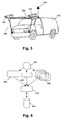
- An example of such a system is illustrated in Fig. 3 , whereby the image receiving means 102 includes image recording means 103 such as cameras 103, such cameras may be mounted on a reference frame on a transportation means 202, as indicated in Fig.
- the inertial measurement unit 206 for determining and/or estimating position information of the local camera frame, which may be part of or provide data to the inertial navigation system information 105.
- the inertial measurement unit may take into account a speed of the transportation means 202, a trajectory of the transportation means 202, etc.
- the system furthermore may comprise an antenna for receiving information from a global positioning system 204 and a frame for supporting the image recording means 103 By way of example, a complete mapping of objects observed and derived from a video sequence recorded along a route may be obtained for a transportation means displacing at a speed between 20-30 km/h whereby video logging is performed at adequate frame rates, e.g.
- the inertial navigation system frame In order to relate the video frames with positional information, time stamps are necessary for each captured video frame and accurate synchronization with position information about the transportation means, i.e. the inertial navigation system frame, is needed.
- the system may operate as described above, whereby the position information for the control points is taken into account for correcting for drift of the inertial navigation system.
- the inertial navigation system however typically may suffer from such short-term drift and can, using the control point position information, be compensated to achieve high positional accuracies. Such correction may be performed using control points, e.g. ground control points, measured in the field at regular intervals.
- the control points can be determined in the video images or dynamic images and, taking into account the predicted accuracy associated with the measurements, e.g. three dimensional (3D) measurements, of the control points due to digitisation errors, distance to the camera and/or calibration accuracy, and the control point information can be propagated along the video track in forward and backward direction.
- 3D three dimensional
- the information flow may be for example as indicated in Fig. 4 .
- the information may be synchronised using a synchronisation clock providing a synchronisation signal 402.
- Information corresponding with inertial navigation system data 404 and image data 406 obtained from within the inertial navigation system are combined together with positional information 408 of at least one control point for which an image is recorded in the image data 406.
- This information is processed in the image processing means 108, whereby positional information 410 for an object in the environment is derived.
- This information is then stored in a storing system.
- Such stored information 412 may further comprise metadata concerning the object in the environment, whereby the content thereof may depend on the specific application that is envisaged.
- the present invention relates to a method for generating position determination information.
- a method for generating position determination information comprises obtaining at least one image of the environment and obtaining control point position information, e.g. absolute geographic position information.
- the method furthermore comprises associating the control point position information to the image of the at least one control point present in the at least one image of the environment.
- the method comprises deriving positional or size related information regarding an object in the environment by using the image and thereby taking into account the positional information of the imaged control point.
- the method furthermore may take into account information from the inertial navigation system for deriving positional or size related information regarding an object in the environment by using the image.
- the method may comprise using a stochastic filter, such as e.g. a Kalman filter to fuse the control point information with the imaged data.
- the method furthermore may comprise a step of determining whether the accuracy of the system is significantly high. If the accuracy is not within a predetermined criterion, the accuracy may be increased by increasing the number of control points, e.g. by increasing the density of the network of control points. It may inform the user that a larger number of control points is required.
- the method may comprise a step for deciding whether to use global positioning information where available and whether to use the method based on control point information associated to image points as described above.
- the latter may be determined in view of availability of global positioning information, e.g. depending on obstruction of the global positioning signal by the environment, in view of the required accuracy, in view of the required efficiency, etc.
- the method furthermore comprises, for a known network of control points, determining a suitable track for obtaining track information with high accuracy. The latter may be performed by selecting different tracks along the points of interest and evaluating the distribution of the control points along the route of interest and determining an accuracy for the different tracks. The track with the highest accuracy then may be selected.
- the present invention relates to an application and a system for running it for mapping or surveying an area, path, object or set of objects, whereby use is made of position determination information as obtained using a system according to the first aspect or a method according to the second aspect.
- Such an application may be used in transportation means, e.g. vehicles, for providing a route along which a person needs to travel, in a surveying system, etc.
- the present invention furthermore relates to a computer program product assisting in performing a method as described above.
- the present invention relates to a computer program product for driving a camera for obtaining at least one image according to a method for generating position determining information as described above.
- the image data collection thereby may be adapted such that control points are imaged in the image of the environment taken.
- the present invention relates to a computer program product for controlling the camera and performing system calibration based on position information about at least one control point which is present in the at least one image of the environment as can be used in a method for generating position determining information.
- the present invention relates to a computer program product for data synchronisation and acquisition by the system for obtaining at least one image and a corresponding system as can be used in a method for generating position determining information.
- the data synchronisation thereby may comprise synchronising the absolute geographic position information for the control points visible in the at least one image of the environment and the data obtained by the imaging system.
- the present invention relates to a computer program product for data integration between the control point information and the image of the environment or associated data concerning the camera reference frame.
- the software may be adapted for three dimensional digitalisation of video images.
- the computer program product may be adapted for planning a track for determining position determination information with a given accuracy.
- the track thereby may be adapted in view of the control points available along the track, such that control points may be present at regular intervals throughout the track, i.e. that no large gaps occur wherein no control point information is present for images along the track.
- control points may be present at regular intervals throughout the track, i.e. that no large gaps occur wherein no control point information is present for images along the track.
- different tracks can be compared and the track resulting in the highest accuracy may be selected to be followed for determining position related information.
- Fig. 5 shows one configuration of processing system 500 that includes at least one programmable processor 503 coupled to a memory subsystem 505 that includes at least one form of memory, e.g., RAM, ROM, and so forth.
- the processor 503 or processors may be a general purpose, or a special purpose processor, and may be for inclusion in a device, e.g., a chip that has other components that perform other functions.
- one or more aspects of the present invention can be implemented in digital electronic circuitry, or in computer hardware, firmware, software, or in combinations of them.
- the processing system may include a storage subsystem 507 that has at least one disk drive and/or CD-ROM drive and/or DVD drive.
- a display system, a keyboard, and a pointing device may be included as part of a user interface subsystem 509 to provide for a user to manually input information. Ports for inputting and outputting data also may be included. More elements such as network connections, interfaces to various devices, and so forth, may be included, but are not illustrated in Fig. 5 .
- the various elements of the processing system 500 may be coupled in various ways, including via a bus subsystem 513 shown in Fig. 5 for simplicity as a single bus, but will be understood to those in the art to include a system of at least one bus.
- the memory of the memory subsystem 505 may at some time hold part or all (in either case shown as 511) of a set of instructions that when executed on the processing system 500 implement the steps of the method embodiments described herein.
- a processing system 500 such as shown in Fig. 5 is prior art
- a system that includes the instructions to implement aspects of the methods for generating positional information of an object in an environment is not prior art, and therefore Fig. 5 is not labelled as prior art.
- the present invention also includes a computer program product which provides the functionality of any of the methods according to the present invention when executed on a computing device.
- Such computer program product can be tangibly embodied in a carrier medium carrying machine-readable code for execution by a programmable processor.
- the present invention thus relates to a carrier medium carrying a computer program product that, when executed on computing means, provides instructions for executing any of the methods as described above.
- carrier medium refers to any medium that participates in providing instructions to a processor for execution. Such a medium may take many forms, including but not limited to, non-volatile media, and transmission media.
- Non volatile media includes, for example, optical or magnetic disks, such as a storage device which is part of mass storage.
- Computer readable media include, a CD-ROM, a DVD, a flexible disk or floppy disk, a tape, a memory chip or cartridge or any other medium from which a computer can read.
- Various forms of computer readable media may be involved in carrying one or more sequences of one or more instructions to a processor for execution.
- the computer program product can also be transmitted via a carrier wave in a network, such as a LAN, a WAN or the Internet.
- Transmission media can take the form of acoustic or light waves, such as those generated during radio wave and infrared data communications. Transmission media include coaxial cables, copper wire and fibre optics, including the wires that comprise a bus within a computer.
- a recalibration between the absolute geographic reference system and the inertial navigation system can be performed in a reliable way.
- a re-calibration can be performed even without halting the system.
- a re-calibration is only little dependent on the environment, as it e.g. is not influenced by e.g. obstructed GPS signals.
- Embodiments of the present invention allow to obtain centimetre accuracy by providing a solution for the drift of the inertial navigation system, which in some cases may be up to 1 to 2 cm drift each second.
Abstract
The present invention relates to a system (100) and method for generating position determination information and to applications using it. Such a system comprising an image receiving means (102) for obtaining at least one image of the environment, such as e.g. a stereo image measuring device. The system furthermore comprises a control point information obtaining means (104) for obtaining control point position information about a position of at least one control point (152) in the environment. The system also comprises an image processing means (108) for associating said control point position information about a position of the at least one control point (152) in the environment to an image of the at least one control point (152) in the at least one image of the environment and for deriving, from the at least one image of the environment, position information of at least one object (202) in the environment taking into account the associated position information of the image of the at least one control point (152).
Description
- The present invention relates to a method and system for determining positions of objects, e.g. in a three dimensional environment. More particularly, the present invention relates to a method and system for determining a position of an object using a mobile system, e.g. for mapping and navigation.
- To date, the use of mapping systems and street-level geospatial imaging, e.g. for use in motor vehicles or for imaging purposes, has been widely spread and still is rapidly growing. This imposes not only the requirement that more and more areas can be mapped appropriately, but it also imposes additional requirements regarding accuracy, resulting in a need for efficient and reliable systems for generating position determination and/or mapping information having a high level of accuracy.
- A known way of generating position determination information or mapping information uses an image based mobile mapping system. One example is the GPSVan developed by the Center for Mapping at the Ohio State University [1]. This mobile mapping system is designed to map railway, highway and the transportation infrastructure such as for example roads, signs, and bridges while traveling at normal traffic speed. The GPSVan positioning module uses a differential global positioning system (DGPS) and an inertial navigation system (INS) to record the vehicle's position during temporary global positioning system data outages. The positioning of the vehicle is good to 10 cm at three-second intervals (i.e. 0.3 frames/sec) when GPS data is available. GPS data outages of 30 s, 60 s and 120 s cause the positioning degradation to the level of 0.2 m, 0.4 m and 1.0 m, respectively.
- A system using similar features is VISAT, developed at the University of Calgary. VISAT uses a high accuracy strapdown inertial navigation system to provide high quality angular orientation parameters of the CCD cameras, along with positional orientation parameters from DGPS. An INS position accuracy of 10-30 cm is reported depending on the GPS outage period (30 sec - 3 min). The accuracy is also dependent of the trajectory taken (straight line versus curve). The accuracy reported is only on the position of the INS. 3D measurement of field objects in the stereo images will be less accurate depending on the distance to the camera.
-
US patent 6,526,352 describes an arrangement and method for mapping a road during travel of a vehicle having two data acquisition modules arranged on sides of the vehicle, each including a GPS receiver and antenna for enabling the vehicle's position to be determined and a linear camera which provides one-dimensional images of an area on the respective side in a vertical plane perpendicular to the road such that information about the road is obtained from a view in a direction perpendicular to the road. A processor unit forms a map database of the road by correlating the vehicle's position and the information about the road. Instead of or in addition to the linear cameras, scanning laser radars are provided and transmit waves downward in a plane perpendicular to the road and receive reflected waves to provide information about distance between the laser radars and the ground for use in forming the database. - It is an object of the present invention to provide good methods and systems for determining position of objects. It is an advantage of embodiments according to the present invention that systems and methods are provided allowing good absolute positional accuracy for determining position of objects. It is an advantage of embodiments according to the present invention that a reliable solution is provided for a positioning system based on image information. It is an advantage of embodiments of the present invention that the reliability is good over the full trajectory, independent of the environmental features present. It is an advantage of some embodiments of the present invention that an absolute positional accuracy of 10cm or better can be obtained.
- The above objective is accomplished by a method and device according to the present invention.
- The present invention relates to a system for generating position determination information, the system comprising an image receiving means for obtaining at least one image of the environment, a control point information obtaining means for obtaining control point position information about a position of at least one control point in the environment, an image processing means for associating said control point position information about a position of the at least one control point in the environment to an image of the at least one control point in the at least one image of the environment and for deriving, from the at least one image of the environment, position information of at least one object in the environment taking into account the associated position information of the image of the at least one control point. The control point information may be obtained from a data repository, e.g. it may be a data repository within the system, e.g. local to the system, such as stored in a solid state memory, a magnetic disk such as a hard drive, an optical disk such as a CD-ROM or DVD-ROM or any other storage device or the control information may be obtained via any form of communication path including wire, fibre, wireless communication paths. The control point information is preferably information not derived directly from any image of the environment concurrently obtained from the image receiving means.
- It is an advantage of embodiments according to the present invention that a high positional accuracy can be guaranteed over the full trajectory to be covered. It furthermore is an advantage of embodiments of the present invention that the measurements are independent of the availability of highly accurate GPS data, which often cannot be guaranteed over the full trajectory in view of connectivity to global positioning system data.
- It is an advantage of embodiments according to the present invention that highly accurate 3D measurements can be carried out, e.g. using integrated positional and stereo data captured on a mobile support.
- Position information about at least one imaged object in the environment thus may be obtained by reference to positional information of imaged control points in the image of the environment obtained, not solely by reference to the vehicle from where the images are recorded.
- The position information about a position of control points in the environment may be geographic position information with respect to a reference system fixed to the surface of the earth. The geographic position information also may be position information with respect to a surface of an ellipsoid modelling the earth.
- The at least one image of the environment may comprise a three dimensional image.
- The at least one image of the environment may comprise a stereoscopic image.
- The at least one image of the environment may comprise a dynamic image. The dynamic image may be a video image.
- The image processing means may furthermore be adapted for determining an image of the control points in the at least one image of the environment.
- The image receiving means may comprise at least one image recording means for recording the at least one image of the environment. The image recording means may be a camera.
- The image receiving means may comprise at least two image recording means for recording the image of the environment.
- The at least one image recording means may have a fixed position in an inertial navigation system, wherein the image processing means furthermore may take into account inertial navigation system information for determining the position of the at least one imaged object. The image processing means may take into account the relative position of the at least one image recording means.
- The image processing means may comprise a stochastic filter for associating said control point position information about a position of the at least one control point in the environment to an image of the at least one control point in the at least one image of the environment. The stochastic filter may be a Kalman filter.
- The system may furthermore comprise an accuracy control system adapted for increasing the number of control points used to obtain a predetermined accuracy.
- It is an advantage of embodiments of the present invention that the overall degree of accuracy for position determination required can be adapted by selecting the density of control points, e.g. ground control points, used for compensating drift. It is an advantage of embodiments of the present invention that the required accuracy for the inertial navigation system can be reduced, e.g. allowing a larger drift of the inertial navigation system, by appropriately selecting the data of ground control points used, i.e. for example by selecting a higher density of ground control points. The density of the control points, e.g. control point network, allows to compensate for the inertial navigation system drift.
- The system may furthermore comprise a selecting means for selecting between the image processing means and a data processing means based on a global positioning system.
- The at least one image may comprise dynamic images and the image processing means may be adapted for, in a given frame, taking into account position control information of control points associated in a previous and/or a following frame.
- The system may comprise an inertial navigation system for determining determine relative movement of an object in six degrees of freedom in space.
- The system furthermore may comprise a track planning means or may be adapted for selecting from a plurality of tracks based on available control points, a track having a suitable accuracy for an application envisaged.
- The present invention also relates to a method for generating position determination information in an environment, the method comprising obtaining at least one image of the environment, obtaining position information about at least one control point, associating position information about a position of the at least one control point in the environment to an image of the at least one control point in the at least one image of the environment, and deriving, from the at least one image of the environment, position information of at least one object in the environment taking into account the associated position information of the image of the at least one control point. The control point information may be obtained from a data repository, e.g. it may be a data repository within the system, e.g. local to the system, such as stored in a solid state memory, a magnetic disk such as a hard drive, an optical disk such as a CD-ROM or DVD-ROM or any other storage device or the control information may be obtained via any form of communication path including wire, fibre, wireless communication paths. The control point information is preferably information not derived directly from any concurrently obtained image of the environment.
- The at least one image of the environment is a three dimensional image.
- Obtaining at least one image of the environment may comprise recording a stereoscopic image of the environment.
- Associating position information about a position of the at least one control point in the environment to an image of the at least one control point in the at least one image of the environment may comprise using a stochastic filter.
- The stochastic filter may be a Kalman filter.
- The method furthermore may comprise controlling the number of control points for obtaining a predetermined accuracy.
- The method furthermore may comprise selecting deriving positional information taking into account the associated position information of the image of the at least one control point or deriving positional information of the object based on a global positioning system.
- The at least one image may comprise a plurality of frames, wherein deriving positional information of the object using one frame comprises taking into account positional information of control points detected in previous frames and positional information of control points detected in further frames.
- The present invention also relates to a computer program product for, when run on a computer, performing a method as described above.
- The present invention furthermore relates to a machine readable data storage device storing such a computer program product and/or to transmission of such a computer program product over a local or wide area telecommunications network.
- The present invention also relates to an application for mapping or surveying an object, the application using position determination information obtained with a system as described above or a using a method as described above.
- The present invention also relates to an image of an object in an environment, the image comprising position information obtained with a system as described above or using a method as described above.
- It is an advantage of embodiments of the present invention that not only the high accuracy positional requirements are obtained, but also that these are obtained consistently over the full trajectory of the object, even if significantly different conditions are present at different areas of the trajectory.
- It is also an advantage of embodiments of the present invention that the reliability information allows a user to validate if accuracy performance is reached with the given system settings. This information for example allows to plan the field work to collect the control point network, e.g. ground control point network, before the start of the data collection.
- It furthermore is an advantage of embodiments according to the present invention that the system and method allows to replan in an efficient and user-friendly way by adding additional control points, e.g. ground control points, in order to obtain the expected accuracy.
- It is an advantage of embodiments of the present invention that the obtained methods and systems can be easily combined with existing methods and systems for generating position determination information, such as e.g. solutions based on global positioning system information in combination with the inertial navigation system, e.g. for areas where a good global positioning system performance is guaranteed.
- It is an advantage of the present invention that accurate three dimensional measurements in world coordinate system can be obtained based on video images recorded from a mobile support. It is an advantage of the system and method used that a user, e.g. land surveyor, can digitally map object boundaries in the field without being on that location, e.g. from behind his desk, with a high absolute positional accuracy, e.g. an accuracy better than 30cm, preferably better than 25cm, more preferably better than 20cm, even more preferably better than 15cm, still more preferably better than 10cm.
- It is an advantage of embodiments according to the present invention that external geographic information can be used for production of new position determination information data.
- Particular and preferred aspects of the invention are set out in the accompanying independent and dependent claims. Features from the dependent claims may be combined with features of the independent claims and with features of other dependent claims as appropriate and not merely as explicitly set out in the claims.
- Although there has been constant improvement, change and evolution of devices in this field, the present concepts are believed to represent substantial new and novel improvements, including departures from prior practices, resulting in the provision of more efficient, stable and reliable devices of this nature.
- The teachings of the present invention permit the design of improved methods and apparatus for determining position of objects, for example improved methods and apparatus for mapping and navigation.
- The above and other characteristics, features and advantages of the present invention will become apparent from the following detailed description, taken in conjunction with the accompanying drawings, which illustrate, by way of example, the principles of the invention. This description is given for the sake of example only, without limiting the scope of the invention. The reference figures quoted below refer to the attached drawings.
-
-
Fig. 1 is a schematic overview of standard and optional parts of a system for generating position determination information according to embodiments of the present invention. -
Fig. 2 is a schematic illustration of the relative positioning of a vehicle with respect to a control point, as can be used in embodiments according to the present invention.. -
Fig. 3 vehicle for recording position determination information or mapping information as can be used in embodiments according to the present invention. -
Fig. 4 is a schematic overview of information flow that may occur in embodiments according to the present invention. -
Fig. 5 is a schematic overview of a computing system as can be used for carrying out the methods according to embodiments of the present invention. - In the different figures, the same reference signs refer to the same or analogous elements.
- The present invention will be described with respect to particular embodiments and with reference to certain drawings but the invention is not limited thereto but only by the claims. The drawings described are only schematic and are non-limiting. In the drawings, the size of some of the elements may be exaggerated and not drawn on scale for illustrative purposes. The dimensions and the relative dimensions do not correspond to actual reductions to practice of the invention.
- Furthermore, the terms first, second and the like in the description and in the claims, are used for distinguishing between similar elements and not necessarily for describing a sequence, either temporally, spatially, in ranking or in any other manner. It is to be understood that the terms so used are interchangeable under appropriate circumstances and that the embodiments of the invention described herein are capable of operation in other sequences than described or illustrated herein.
- It is to be noticed that the term "comprising", used in the claims, should not be interpreted as being restricted to the means listed thereafter; it does not exclude other elements or steps. It is thus to be interpreted as specifying the presence of the stated features, integers, steps or components as referred to, but does not preclude the presence or addition of one or more other features, integers, steps or components, or groups thereof. Thus, the scope of the expression "a device comprising means A and B" should not be limited to devices consisting only of components A and B. It means that with respect to the present invention, the only relevant components of the device are A and B.
- Reference throughout this specification to "one embodiment" or "an embodiment" means that a particular feature, structure or characteristic described in connection with the embodiment is included in at least one embodiment of the present invention. Furthermore, the particular features, structures or characteristics may be combined in any suitable manner, as would be apparent to one of ordinary skill in the art from this disclosure, in one or more embodiments.
- Similarly it should be appreciated that in the description of exemplary embodiments of the invention, various features of the invention are sometimes grouped together in a single embodiment, figure, or description thereof for the purpose of streamlining the disclosure and aiding in the understanding of one or more of the various inventive aspects. This method of disclosure, however, is not to be interpreted as reflecting an intention that the claimed invention requires more features than are expressly recited in each claim. Furthermore, while some embodiments described herein include some but not other features included in other embodiments, combinations of features of different embodiments are meant to be within the scope of the invention, and form different embodiments, as would be understood by those in the art. Furthermore, an element described herein of an apparatus embodiment is an example of a means for carrying out the function performed by the element for the purpose of carrying out the invention.
- In the description provided herein, numerous specific details are set forth. However, it is understood that embodiments of the invention may be practiced without these specific details. In other instances, well-known methods, structures and techniques have not been shown in detail in order not to obscure an understanding of this description.
- The following terms are provided solely to aid in the understanding of the invention. A global positioning system relates to a positioning system that is satellite-based and allows to determine a latitude, longitude and elevation of a GPS receiver on the earth surface. It thus provides a geographic positioning or localisation of objects. An inertial navigation system is a relative positioning system allowing determination of the relative movement of an object. It may e.g. use angular rate sensors and accelerometers together with a computational unit. It may allow to determine relative movement of an object in six degrees of freedom in space, namely for three translational directions (x,y,z) and three rotational directions (theta, psi, phi). A geographic or geodetic reference frame or absolute reference frame in the present application is a reference frame linked to a specific ellipsoid used to model the earth, allowing to provide well-defined geographic reference coordinates for objects on the earth.
- The invention will now be described by a detailed description of several embodiments of the invention. It is clear that other embodiments of the invention can be configured according to the knowledge of persons skilled in the art without departing from the true spirit or technical teaching of the invention, the invention being limited only by the terms of the appended claims.
- In a first aspect, the present invention relates to a system for generating position determining information. Such position determining information may for example be suitable for mapping applications. A schematic representation of an exemplary system 100 for generating position determination information is shown in
Fig.1 . The system 100 comprises an image receiving means 102 for obtaining an image of the environment. In a preferred embodiment, the image of the environment is a three dimensional image. The image may e.g. be a stereoscopic image, for example obtained by acquiring stereo images using a setup of two or more camera's mounted on a frame. The images may be video images or a set of images recorded over time, i.e. at given intervals such as for example at regular intervals. The image of the environment may be obtained from an external recording means, or, preferably, the image receiving means 102 may comprise at least onecamera 103. The at least onecamera 103 may be a digital or analogue camera. The at least onecamera 103 may be calibrated for internal and external parameters so that for a given frame configuration the at least two dimensional, preferably three dimensional coordinates, of a point in the image can be measured in a local coordinate system associated with the stereo frame. Such an associated local coordinate system or local camera frame from where the image of the environment is taken can be transformed to an absolute reference system using an inertial navigation system (INS). As will be set out later, the imaging recording means orcamera 103 may be a moving system, wherein the images received in the image receiving means 102 are video images or dynamic images recorded for different positions of the imaging recording means orcamera 103 at different moments in time. Such a system can advantageously be used for obtaining position information for mapping systems, as required information may be gathered while the transportation means 202 is moving, resulting in a high efficiency of obtaining position determination information. Such information may then be used and stored in mapping and positioning systems for individual users, such as e.g. in mapping and positioning systems for use in vehicles, like for example cars. Data acquisition and/or image calculation based on the recorded or imaged data may be performed using any suitable driving applications, e.g. based on or built using LabView. - The system 100 furthermore may comprise a means for obtaining control point information, also referred to as a control point
information obtaining means 104, allowing to obtain position information about a position of at least onecontrol point 152 in the environment. Such acontrol point 152 in the environment may be any type ofcontrol point 152 for which geographic referenced position information is available or can be made available, such as positions of traffic signs, position of small well localised environmental objects, etc. A survey instrument may be used for measuring a number of control points on site. The control point information thereby preferably comprises a geographical position of the control point, which may be measured for example using a global positioning system, a surveyor or in any other suitable way. It is an advantage that such information can be determined even for places where no GPS is operational e.g. due to environmental disturbances, as also other means of determining geographical position can be used. The means for obtaining control point information may obtain such information via a communication path such as e.g. a network, from one ormore storing systems 106, such as one or a plurality of databases or look up tables. Such information also may be stored locally in the system for generating position determining information. Such control points will be taken into account for determining position determination information for objects in the image of the environment taken, using an image of the at least one control point in the at least one image of the environment. Imaging of such acontrol point 152 in the environment is schematically illustrated inFig. 2 . The at least onecontrol point 152 preferably is a plurality of control points. Preferably a network of control points is present providing absolute geographical position information near all places of interest. - The system 100 furthermore may comprise an inertial navigation system (INS) 105 as indicated in
Fig. 1 , which is a relative positioning system allowing determination of the relative movement of an object and which preferably is used, together with control points, to transform the local camera frame to an absolute reference frame. Theinertial navigation system 105 thus may allow determination of the relative movement of an object. It may e.g. use angular rate sensors and accelerometers together with a computational unit. It may allow to determine relative movement of an object in six degrees of freedom in space, namely three translational directions, i.e. movement in x, y, z direction, and three rotational directions, i.e. movement by rotation around three axis e.g. over angles theta, psi, phi. Such a system may comprise information about the relative position of the objects in the image with respect to the local camera frame. Information of the inertial navigation system may comprise a relative position, a speed, a viewing angle, position of different image recording means, etc. The inertial navigation system information also may comprise an absolute geographic position of the inertial navigation system, e.g. determined by GPS. In such a case, the system and method according to the present invention then may be used for correcting for drift of the inertial navigation system. - The system 100 furthermore comprises an image processing means 108. The image processing means 108, may be an image processor. The image processing means 108 is adapted for associating the control point position information for the at least one
control point 152 in the environment to an image of the at least onecontrol point 152 in the image of the environment. In this way, absolute geographic position can be obtained by coupling the local camera frame from where the image of the environment is taken to a world coordinate system, i.e. a geographic or geodetic coordinate system. Such geographic position determination may be required e.g. for surveying purposes or mapping purposes. The image of thecontrol point 152 may be identified in any suitable way. This may be performed for example manually. Alternatively, determination ofsuch control points 152 may be performed in an automatic or automated way, e.g. using image recognition algorithms, using neural networks, etc. The image processing means 108 therefore may comprise a controlpoint recognition module 110. The control points may be identified in acquired stereo image frames. - The image processing means 108 furthermore is adapted for deriving, from the image of the environment, position information of at least one object in the environment taking into account the associated position information of the image of the at least one
control point 152. The image processing means 108 furthermore preferably takes into account information from the inertial navigation system. Therefore a data transfer may be provided between the image processing means 108 and the inertial navigation system. Furthermore, if images are recorded from a mobile support, use may be made of associated movement data of the mobile support and the known relative geometry of cameras and positioning instruments. The position and physical dimensions of objects in subsequent stereo image frames may be determined. The latter may be directly in the image wherein a control point is identified or in image frames in between image frames wherein control points can be measured. - The object may be the point of origin of the local camera frame from where the image is recorded, such as e.g. a position of the transportation means for a camera system used, or it may be an object imaged in the image of the environment. In order to couple the control point position information to the position of the transportation means, to the origin or a point in the local camera frame or to the object in the image, the position and viewpoint of the image recording means 103 with which the image is recorded may be taken into account. The position information can be geographic position information about an imaged object, based on the relative position of the imaged object in the at least one image of the environment, and the absolute geographic position information for the control points imaged in the image of the environment. Determination of such an absolute geographic position information of at least one object of interest in the environment may for example be obtained by taking into a relative position of the object of interest with respect to the at least one control point of interest. The absolute geographic position information of at least one object of interest in the environment may also be obtained by taking into account a relative position of the object of interest with respect to a local camera frame from which the image is obtained and the relative position of the control point(s) 152 for which absolute geographic position is known. In order to determine absolute geographic positions of objects, the coordinates of the local camera framework from which the image is received or the coordinates of the local camera framework coupled to the image thus preferably is transferred to a world coordinate system, also referred to as geographic reference frame. To calculate this transformation, a so-called "hand-eye calibration" may be performed to place the geometry of the imaging frame work in a world coordinate system. Alternatively, or in addition thereto, the initial position of the local camera frame may be predetermined and deriving, from the image of the environment, position information of at least one object in the environment taking into account the associated position information of the image of the at least one
control point 152 may be performed to correct for drift of the system, e.g. of the inertial navigation system, over time. In other words, position information of control points in the image may be used for recalibrate the position of the system, e.g. in order to correct for the drift of the inertial navigation system. Such a drift may be an uncontrolled drift being up to 1 or 2 cm/sec. - The image processing means 108 may use whole or part of the imaged environment. It may comprise a setting unit for setting the search area to be used for image correlation processing based on the control points determined in the control
point recognition module 110. In this way, the reference data being position information data and the image data that will be combined are selected. The image processing means 108 may perform an orientation calculation for this data in order to obtain appropriate matching. - The image processing means 108 may integrate forward and backward control points, and the different observations of the object in overlapping or subsequent image frames. Furthermore, the predicted positional accuracy of the 3D measurement due to distance to the device, hardware properties and digitalisation errors are taken into account.
- The system 100 furthermore may comprise an output means 112 for exporting the obtained positional information for the object, e.g. the three dimensional measurement information for the object. The obtained information may be position related information but furthermore may comprise physical dimensions of objects. Such information may be exported together with metadata. Such metadata may be documenting the estimated accuracy of the measurement. Other information related to the object also may be included in the metadata. Such information may depend on the application for which the data will be used. The output means may comprise a display unit such as e.g. a stereo monitor, a personal computer monitor or the like allowing imaging, such as e.g. providing stereoscopic vision.
- The image processing means 108 thus may be adapted for processing, computing, calculating, determining or the like of data, which refers to an action and/or processes of a computer or computing system, or similar electronic computing device, that manipulate and/or transform data represented as physical, such as electronic, quantities into other data similarly represented as physical quantities. Such an image processing means 108 may comprise "CPU" or processor, which may refer to any device or portion of a device that processes electronic data, e.g., from registers and/or memory to transform that electronic data into other electronic data that, e.g., may be stored in registers and/or memory. The term memory as used herein also encompasses a storage system such as a disk drive unit. The image processing means 108 may include a memory subsystem including main RAM and/or a static RAM, and/or ROM. The image processing means 108 may comprise a graphics processing unit. The image processing means 108 may include one or more processors. The processors may accept computer-readable (also called machine-readable) code containing instructions. A bus subsystem may be included for communicating between the components.
- In preferred embodiments according to the present invention, the image processing means 108 comprising using a
stochastic filter 120 for associating at least one control point to the at least one image of the environment. Such astochastic filter 120 may e.g. be a Kalman filter. Thefilter 120 may fuse the data to predict the absolute position of an object of the image associating control point information with the at least one image of the environment. Such association may be used for calibration or re-calibration of the inertial navigation system to absolute geographical coordinates. The filter may be designed to fuse data of a control point network, e.g. ground control point network with the inertial navigation system measurements. Such a filter may allow to predict the absolute position of local camera frame from wherein the image is taken or to predict the absolute position of objects in the image of the environment. The position of such points may be determined by the position of the local camera frame estimated using information from the imaging technique, such as e.g. stereo photogrammetry, and the known position of the control points and by inertial navigation system measurements. The inertial navigation system measurements may be based on previously calibrated positions of the local reference frame or may be based on a different technique for obtaining position. In addition the stochastic filter, such as e.g. the Kalman filter, allows to estimate the reliability of the prediction, based on an error covariance matrix for the inertial navigation system and the photogrammetric measurements. The error covariance matrix on the photogrammetric measurements depends among others on the imaging geometry (baseline, CCD resolution, lens focal length) and the distance of the observed control points, e.g. ground control points, to the camera reference frame. Based on the stereo triangulation of the control points, e.g. ground control points, in the images and by using error propagation, the error covariance on the position can be estimated. The error propagation in this process relates the uncertainty on the user input to the uncertainty of the position estimation taking into account all the affecting parameters. The uncertainty on the user input is measured by estimating the (sub)pixel accuracy during the digitalisation process. - In one example, the propagation process can be modeled as follows. In the most simple case, a camera geometry with parallel image planes can be assumed, aligned epipolar lines and image coordinate systems centered at the focal point of each camera. Let the image coordinates be given by XL=[xL, yL] and XR=[xR, yR] in the left and right image, respectively. Considering these as normally distributed random vectors with means mL and mR and covariance matrices VL and VR. From XL and XR the coordinates [X, Y, Z]T of the 3D point P can be estimated. The simple approach of using the ideal noise-free triangulation equations P = [X,Y,Z]T = f(XL, XR), or


- In some embodiments according to the present invention, the image processing means furthermore comprises an accuracy control means 130 for determining whether for a given session accuracy falls within predetermined levels, e.g. for determining whether the accuracy is within the expected margins. Such a system furthermore may be adapted for automatically increasing the number of control points used for generating position determination information. The system thus may be adapted for selecting a density of the network of control points required for a required accuracy. Alternatively or in addition thereto, the system furthermore may be adapted for selecting different control points for obtaining a better accuracy. If not enough network control points are available to obtain the required accuracy, the system may inform the user that the expected accuracy can not be reached and may indicate that measurement of additional control point positions in the filed are required. Such an accuracy control may be performed in an automated and/or automatic way. It may be performed using a predetermined algorithm, based on neural networks, etc. In preferred embodiments, the image processing means may integrate forward and backward control points and the different observations of the object in overlapping image frames in order to have an accurate determination of the position or physical dimensions of an object in the image. The accuracy control means 130 may use information from the
stochastic filter 120, as set out above, although the invention is not limited thereto. - In one particular embodiment, the first aspect relates to a system as described above, whereby the system for generating position determination information is adapted for generating a plurality of position determination information using a moving platform. The image receiving means 102 thereby typically receives a plurality of images, e.g. video images or dynamic images for determining position determination information for objects along a predetermined route. For such an embodiment, part of the system or the full system may be incorporated in a transportation means, such as e.g. a vehicle. An example of such a system is illustrated in
Fig. 3 , whereby the image receiving means 102 includes image recording means 103 such ascameras 103, such cameras may be mounted on a reference frame on a transportation means 202, as indicated inFig. 3 , and thus the local reference frame may be moving. Theinertial measurement unit 206 for determining and/or estimating position information of the local camera frame, which may be part of or provide data to the inertialnavigation system information 105. The inertial measurement unit may take into account a speed of the transportation means 202, a trajectory of the transportation means 202, etc. The system furthermore may comprise an antenna for receiving information from aglobal positioning system 204 and a frame for supporting the image recording means 103 By way of example, a complete mapping of objects observed and derived from a video sequence recorded along a route may be obtained for a transportation means displacing at a speed between 20-30 km/h whereby video logging is performed at adequate frame rates, e.g. with a frame rate of more than 2 frames per second. In order to relate the video frames with positional information, time stamps are necessary for each captured video frame and accurate synchronization with position information about the transportation means, i.e. the inertial navigation system frame, is needed. The system may operate as described above, whereby the position information for the control points is taken into account for correcting for drift of the inertial navigation system. The inertial navigation system however typically may suffer from such short-term drift and can, using the control point position information, be compensated to achieve high positional accuracies. Such correction may be performed using control points, e.g. ground control points, measured in the field at regular intervals. The control points can be determined in the video images or dynamic images and, taking into account the predicted accuracy associated with the measurements, e.g. three dimensional (3D) measurements, of the control points due to digitisation errors, distance to the camera and/or calibration accuracy, and the control point information can be propagated along the video track in forward and backward direction. - In embodiments according to the first aspect of the present invention the information flow may be for example as indicated in
Fig. 4 . The information may be synchronised using a synchronisation clock providing asynchronisation signal 402. Information corresponding with inertialnavigation system data 404 andimage data 406 obtained from within the inertial navigation system are combined together withpositional information 408 of at least one control point for which an image is recorded in theimage data 406. This information is processed in the image processing means 108, wherebypositional information 410 for an object in the environment is derived. This information is then stored in a storing system. Such storedinformation 412 may further comprise metadata concerning the object in the environment, whereby the content thereof may depend on the specific application that is envisaged. - In a second aspect, the present invention relates to a method for generating position determination information. Such a method may e.g. advantageous be performed in a system as described in the first embodiment and may comprise steps corresponding with the functionality of the different components as described in the above system. The method for generating position determination information comprises obtaining at least one image of the environment and obtaining control point position information, e.g. absolute geographic position information. The method furthermore comprises associating the control point position information to the image of the at least one control point present in the at least one image of the environment. Furthermore, the method comprises deriving positional or size related information regarding an object in the environment by using the image and thereby taking into account the positional information of the imaged control point. The method furthermore may take into account information from the inertial navigation system for deriving positional or size related information regarding an object in the environment by using the image. The method may comprise using a stochastic filter, such as e.g. a Kalman filter to fuse the control point information with the imaged data. The method furthermore may comprise a step of determining whether the accuracy of the system is significantly high. If the accuracy is not within a predetermined criterion, the accuracy may be increased by increasing the number of control points, e.g. by increasing the density of the network of control points. It may inform the user that a larger number of control points is required. The method may comprise a step for deciding whether to use global positioning information where available and whether to use the method based on control point information associated to image points as described above. The latter may be determined in view of availability of global positioning information, e.g. depending on obstruction of the global positioning signal by the environment, in view of the required accuracy, in view of the required efficiency, etc. In one embodiment, where video information is obtained by moving a transportation means along a route for which position determination information is to be determined, the method furthermore comprises, for a known network of control points, determining a suitable track for obtaining track information with high accuracy. The latter may be performed by selecting different tracks along the points of interest and evaluating the distribution of the control points along the route of interest and determining an accuracy for the different tracks. The track with the highest accuracy then may be selected.
- In a third aspect, the present invention relates to an application and a system for running it for mapping or surveying an area, path, object or set of objects, whereby use is made of position determination information as obtained using a system according to the first aspect or a method according to the second aspect. Such an application may be used in transportation means, e.g. vehicles, for providing a route along which a person needs to travel, in a surveying system, etc.
- In one aspect, the present invention furthermore relates to a computer program product assisting in performing a method as described above. In one embodiment according to this aspect, the present invention relates to a computer program product for driving a camera for obtaining at least one image according to a method for generating position determining information as described above. The image data collection thereby may be adapted such that control points are imaged in the image of the environment taken.
- In another embodiment according to this aspect, the present invention relates to a computer program product for controlling the camera and performing system calibration based on position information about at least one control point which is present in the at least one image of the environment as can be used in a method for generating position determining information.
- In another embodiment according to the present aspect, the present invention relates to a computer program product for data synchronisation and acquisition by the system for obtaining at least one image and a corresponding system as can be used in a method for generating position determining information. The data synchronisation thereby may comprise synchronising the absolute geographic position information for the control points visible in the at least one image of the environment and the data obtained by the imaging system.
- In another embodiment according to the present aspect, the present invention relates to a computer program product for data integration between the control point information and the image of the environment or associated data concerning the camera reference frame. In these embodiments, the software may be adapted for three dimensional digitalisation of video images.
- The computer program product according to the present aspect may be adapted for planning a track for determining position determination information with a given accuracy. The track thereby may be adapted in view of the control points available along the track, such that control points may be present at regular intervals throughout the track, i.e. that no large gaps occur wherein no control point information is present for images along the track. In other words, if the user has a given network of control points, different tracks can be compared and the track resulting in the highest accuracy may be selected to be followed for determining position related information.
- Furthermore, the above-described method embodiments of the present invention may be implemented in a
processing system 500 such as shown inFig. 5. Fig. 5 shows one configuration ofprocessing system 500 that includes at least oneprogrammable processor 503 coupled to amemory subsystem 505 that includes at least one form of memory, e.g., RAM, ROM, and so forth. It is to be noted that theprocessor 503 or processors may be a general purpose, or a special purpose processor, and may be for inclusion in a device, e.g., a chip that has other components that perform other functions. Thus, one or more aspects of the present invention can be implemented in digital electronic circuitry, or in computer hardware, firmware, software, or in combinations of them. The processing system may include astorage subsystem 507 that has at least one disk drive and/or CD-ROM drive and/or DVD drive. In some implementations, a display system, a keyboard, and a pointing device may be included as part of auser interface subsystem 509 to provide for a user to manually input information. Ports for inputting and outputting data also may be included. More elements such as network connections, interfaces to various devices, and so forth, may be included, but are not illustrated inFig. 5 . The various elements of theprocessing system 500 may be coupled in various ways, including via abus subsystem 513 shown inFig. 5 for simplicity as a single bus, but will be understood to those in the art to include a system of at least one bus. The memory of thememory subsystem 505 may at some time hold part or all (in either case shown as 511) of a set of instructions that when executed on theprocessing system 500 implement the steps of the method embodiments described herein. Thus, while aprocessing system 500 such as shown inFig. 5 is prior art, a system that includes the instructions to implement aspects of the methods for generating positional information of an object in an environment is not prior art, and thereforeFig. 5 is not labelled as prior art. - The present invention also includes a computer program product which provides the functionality of any of the methods according to the present invention when executed on a computing device. Such computer program product can be tangibly embodied in a carrier medium carrying machine-readable code for execution by a programmable processor. The present invention thus relates to a carrier medium carrying a computer program product that, when executed on computing means, provides instructions for executing any of the methods as described above. The term "carrier medium" refers to any medium that participates in providing instructions to a processor for execution. Such a medium may take many forms, including but not limited to, non-volatile media, and transmission media. Non volatile media includes, for example, optical or magnetic disks, such as a storage device which is part of mass storage. Common forms of computer readable media include, a CD-ROM, a DVD, a flexible disk or floppy disk, a tape, a memory chip or cartridge or any other medium from which a computer can read. Various forms of computer readable media may be involved in carrying one or more sequences of one or more instructions to a processor for execution. The computer program product can also be transmitted via a carrier wave in a network, such as a LAN, a WAN or the Internet. Transmission media can take the form of acoustic or light waves, such as those generated during radio wave and infrared data communications. Transmission media include coaxial cables, copper wire and fibre optics, including the wires that comprise a bus within a computer.
- It is an advantage of embodiments according to the present invention that a recalibration between the absolute geographic reference system and the inertial navigation system can be performed in a reliable way. When the system is a mobile system, such a re-calibration can be performed even without halting the system. Furthermore such a re-calibration is only little dependent on the environment, as it e.g. is not influenced by e.g. obstructed GPS signals.
- It is an advantage of embodiments according to the present invention that it is based on appropriate integration of available data. Embodiments of the present invention allow to obtain centimetre accuracy by providing a solution for the drift of the inertial navigation system, which in some cases may be up to 1 to 2 cm drift each second.
- It is an advantage of embodiments according to the present invention that a system is obtained with high reliability. Whereas global positioning system positioning is sometimes inadequate for surveying purposes, the present invention solves this problem by avoiding the need for global positioning systems.
- It is an advantage of embodiments according to the present invention that control points measured locally in the field at regular intervals and reconstructed in the video images can be used for compensating
- It is an advantage of embodiments according to the present invention that a more stable performance of a system for generating position determination information then when relying only on solutions based on global positioning and inertial navigation systems solutions due to loss of signal, trajectory shape etc. of the latter. The use of a well designed control point network, such as a ground control point network makes a highly accurate and stable system possible.
- It is to be understood that although preferred embodiments, specific constructions and configurations, as well as materials, have been discussed herein for devices according to the present invention, various changes or modifications in form and detail may be made without departing from the invention. For example, any formulas given above are merely representative of procedures that may be used. Functionality may be added or deleted from the block diagrams and operations may be interchanged among functional blocks. Steps may be added or deleted to methods described within the scope of the present invention.
Claims (29)
- A system (100) for generating position determination information, the system comprising- an image receiving means (102) for obtaining at least one image of the environment,- a control point information obtaining means (104) for obtaining control point position information about a position of at least one control point (152) in the environment,- an image processing means (108) for associating said control point position information about a position of the at least one control point (152) in the environment to an image of the at least one control point (152) in the at least one image of the environment and for deriving, from the at least one image of the environment, position information of at least one object in the environment taking into account the associated position information of the image of the at least one control point (152).
- A system (100) according to claim 1, wherein the position information about a position of control points in the environment is geographic position information with respect to a reference system fixed to the surface of the earth.
- A system (100) according to any of the previous claims, wherein the at least one image of the environment comprises a three dimensional image.
- A system (100) according to any of the previous claims, wherein the at least one image of the environment comprises a stereoscopic image.
- A system (100) according to any of the previous claims, wherein the at least one image of the environment comprises a dynamic image.
- A system (100) according to any of the previous claims, wherein the image processing means (108) furthermore is adapted for determining an image of the control points in the at least one image of the environment.
- A system (100) according to any of the previous claims, wherein the image receiving means (102) comprises at least one image recording means (103) for recording the at least one image of the environment.
- A system (100) according to claim 7, wherein the image receiving means (102) comprises at least two image recording means (103) for recording the image of the environment.
- A system (100) according to any of claims 7 to 8, said at least one image recording means (103) having a fixed position in an inertial navigation system, wherein the image processing means (102) furthermore takes into account inertial navigation system information for determining the position of the at least one imaged object.
- A system (100) according to any of the previous claims, wherein the image processing means (108) comprises a stochastic filter for associating said control point position information about a position of the at least one control point (152) in the environment to an image of the at least one control point (152) in the at least one image of the environment.
- A system (100) according to the previous claim, wherein the stochastic filter is a Kalman filter.
- A system (100) according to any of the previous claims, wherein the system (100) furthermore comprises an accuracy control system adapted for increasing the number of control points used to obtain a predetermined accuracy.
- A system (100) according to any of the previous claims, wherein the system (100) furthermore comprises a selecting means for selecting between the image processing means (108) and a data processing means based on a global positioning system.
- A system (100) according to any of the previous claims, the at least one image comprising dynamic images, wherein the image processing means (108) is adapted for, in a given frame, taking into account position control information of control points associated in a previous and/or a following frame.
- A system (100) according to any of the previous claims, the system (100) comprising an inertial navigation system (105) for determining determine relative movement of an object in six degrees of freedom in space.
- A system (100) according to any of the previous claims, wherein the system furthermore comprises a track planning means for selecting from a plurality of tracks based on available control points, a track having a suitable accuracy for an application envisaged.
- A method for generating position determination information in an environment, the method comprising- obtaining at least one image of the environment,- obtaining position information about at least one control point (152)- associating position information about a position of the at least one control point (152) in the environment to an image of the at least one control point (152) in the at least one image of the environment, and- deriving, from the at least one image of the environment, position information of at least one object in the environment taking into account the associated position information of the image of the at least one control point (152).
- A method according to claim 17, wherein the at least one image of the environment is a three dimensional image.
- A method according to any of claims 17 to 18, wherein obtaining at least one image of the environment comprises recording a stereoscopic image of the environment.
- A method according to any of claims 17 to 19, wherein associating position information about a position of the at least one control point (152) in the environment to an image of the at least one control point (152) in the at least one image of the environment comprises using a stochastic filter.
- A method according to claim 20, wherein the stochastic filter is a Kalman filter.
- A method according to any of claims 17 to 21, the method furthermore comprising controlling the number of control points for obtaining a predetermined accuracy.
- A method according to any of claims 17 to 22, the method furthermore comprising selecting deriving positional information taking into account the associated position information of the image of the at least one control point (152) or deriving positional information of the object based on a global positioning system.
- A method according to any of claims 17 to 23, the at least one image comprising a plurality of frames, wherein deriving positional information of the object using one frame comprises taking into account positional information of control points detected in previous frames and positional information of control points detected in further frames.
- A computer program product for, when run on a computer, performing a method according to any of claims 17 to 24.
- A machine readable data storage device storing the computer program product of claim 25.
- Transmission of the computer program product of claim 25 over a local or wide area telecommunications network.
- An application for mapping or surveying an object, the application using position determination information obtained with a system according to any of claims 1 to 16 or a method according to any of claims 17 to 24.
- An image of an object in an environment, the image comprising position information obtained with a system according to any of claims 1 to 16 or a method according to any of claims 17 to 24.
Priority Applications (5)
| Application Number | Priority Date | Filing Date | Title |
|---|---|---|---|
| EP07005759A EP1972893A1 (en) | 2007-03-21 | 2007-03-21 | System and method for position determination |
| CA002680628A CA2680628A1 (en) | 2007-03-21 | 2008-03-20 | System and method for position determination |
| US12/531,812 US20100017115A1 (en) | 2007-03-21 | 2008-03-20 | System and method for position determination |
| PCT/EP2008/053415 WO2008113861A2 (en) | 2007-03-21 | 2008-03-20 | System and method for position determination |
| EP08718123.6A EP2132530B1 (en) | 2007-03-21 | 2008-03-20 | System and method for position determination |
Applications Claiming Priority (1)
| Application Number | Priority Date | Filing Date | Title |
|---|---|---|---|
| EP07005759A EP1972893A1 (en) | 2007-03-21 | 2007-03-21 | System and method for position determination |
Publications (1)
| Publication Number | Publication Date |
|---|---|
| EP1972893A1 true EP1972893A1 (en) | 2008-09-24 |
Family
ID=38267520
Family Applications (2)
| Application Number | Title | Priority Date | Filing Date |
|---|---|---|---|
| EP07005759A Withdrawn EP1972893A1 (en) | 2007-03-21 | 2007-03-21 | System and method for position determination |
| EP08718123.6A Active EP2132530B1 (en) | 2007-03-21 | 2008-03-20 | System and method for position determination |
Family Applications After (1)
| Application Number | Title | Priority Date | Filing Date |
|---|---|---|---|
| EP08718123.6A Active EP2132530B1 (en) | 2007-03-21 | 2008-03-20 | System and method for position determination |
Country Status (4)
| Country | Link |
|---|---|
| US (1) | US20100017115A1 (en) |
| EP (2) | EP1972893A1 (en) |
| CA (1) | CA2680628A1 (en) |
| WO (1) | WO2008113861A2 (en) |
Cited By (5)
| Publication number | Priority date | Publication date | Assignee | Title |
|---|---|---|---|---|
| US8346466B2 (en) | 2009-11-11 | 2013-01-01 | Northrop Grumman Guidance & Electronics | Systems and methods for determining heading |
| CN104919277A (en) * | 2012-12-20 | 2015-09-16 | 大陆-特韦斯贸易合伙股份公司及两合公司 | Method for determining initial data for determining position data of a vehicle |
| EP2510379A4 (en) * | 2009-12-07 | 2016-07-27 | Cognitech Inc | System and method for determining geo-location(s) in images |
| CN106462244A (en) * | 2014-06-12 | 2017-02-22 | 谷歌公司 | Methods and systems for calibrating sensors using recognized objects |
| CN108256411A (en) * | 2016-12-28 | 2018-07-06 | 沃尔沃汽车公司 | By the method and system of camera review vehicle location |
Families Citing this family (57)
| Publication number | Priority date | Publication date | Assignee | Title |
|---|---|---|---|---|
| US8989468B2 (en) * | 2007-05-25 | 2015-03-24 | Definiens Ag | Generating an anatomical model using a rule-based segmentation and classification process |
| US8699755B2 (en) * | 2009-02-20 | 2014-04-15 | Navteq B.V. | Determining travel path features based on retroreflectivity |
| US20110039573A1 (en) * | 2009-08-13 | 2011-02-17 | Qualcomm Incorporated | Accessing positional information for a mobile station using a data code label |
| US8634982B2 (en) * | 2009-08-19 | 2014-01-21 | Raytheon Company | System and method for resource allocation and management |
| JP2011117739A (en) * | 2009-11-30 | 2011-06-16 | Fujitsu Ten Ltd | Navigation system and vehicle-mounted device |
| US8855929B2 (en) * | 2010-01-18 | 2014-10-07 | Qualcomm Incorporated | Using object to align and calibrate inertial navigation system |
| US9229089B2 (en) | 2010-06-10 | 2016-01-05 | Qualcomm Incorporated | Acquisition of navigation assistance information for a mobile station |
| US9219985B2 (en) | 2010-07-27 | 2015-12-22 | University Of Regina | Method and system for cooperative stochastic positioning in a mobile environment |
| US8571722B2 (en) | 2010-10-22 | 2013-10-29 | Toyota Motor Engineering & Manufacturing North America, Inc. | Method for safely parking vehicle near obstacles |
| US8396730B2 (en) * | 2011-02-14 | 2013-03-12 | Raytheon Company | System and method for resource allocation and management |
| US8799201B2 (en) | 2011-07-25 | 2014-08-05 | Toyota Motor Engineering & Manufacturing North America, Inc. | Method and system for tracking objects |
| US9183638B2 (en) * | 2011-08-09 | 2015-11-10 | The Boeing Company | Image based position determination |
| JP5879883B2 (en) * | 2011-09-30 | 2016-03-08 | カシオ計算機株式会社 | Positioning device, positioning method and program |
| US9385816B2 (en) | 2011-11-14 | 2016-07-05 | Intel Corporation | Methods and arrangements for frequency shift communications by undersampling |
| US9163948B2 (en) * | 2011-11-17 | 2015-10-20 | Speedgauge, Inc. | Position accuracy testing system |
| US9516223B2 (en) | 2012-06-06 | 2016-12-06 | Apple Inc. | Motion-based image stitching |
| US9148250B2 (en) | 2012-06-30 | 2015-09-29 | Intel Corporation | Methods and arrangements for error correction in decoding data from an electromagnetic radiator |
| US9014564B2 (en) | 2012-09-24 | 2015-04-21 | Intel Corporation | Light receiver position determination |
| US9203541B2 (en) | 2012-09-28 | 2015-12-01 | Intel Corporation | Methods and apparatus for multiphase sampling of modulated light |
| US9178615B2 (en) | 2012-09-28 | 2015-11-03 | Intel Corporation | Multiphase sampling of modulated light with phase synchronization field |
| US9218532B2 (en) | 2012-09-28 | 2015-12-22 | Intel Corporation | Light ID error detection and correction for light receiver position determination |
| US9590728B2 (en) | 2012-09-29 | 2017-03-07 | Intel Corporation | Integrated photogrammetric light communications positioning and inertial navigation system positioning |
| US9214021B2 (en) * | 2012-10-09 | 2015-12-15 | The Boeing Company | Distributed position identification |
| US9350916B2 (en) | 2013-05-28 | 2016-05-24 | Apple Inc. | Interleaving image processing and image capture operations |
| US9310851B2 (en) | 2013-06-03 | 2016-04-12 | Amchael Visual Technology Corporation | Three-dimensional (3D) human-computer interaction system using computer mouse as a 3D pointing device and an operation method thereof |
| US9491360B2 (en) | 2013-06-06 | 2016-11-08 | Apple Inc. | Reference frame selection for still image stabilization |
| US9384552B2 (en) | 2013-06-06 | 2016-07-05 | Apple Inc. | Image registration methods for still image stabilization |
| US9262684B2 (en) | 2013-06-06 | 2016-02-16 | Apple Inc. | Methods of image fusion for image stabilization |
| US9542585B2 (en) | 2013-06-06 | 2017-01-10 | Apple Inc. | Efficient machine-readable object detection and tracking |
| US9678583B2 (en) | 2013-07-23 | 2017-06-13 | University Of Kentucky Research Foundation | 2D and 3D pointing device based on a passive lights detection operation method using one camera |
| US9201519B2 (en) | 2013-08-14 | 2015-12-01 | Amchael Visual Technology Corporation | Three-dimensional pointing using one camera and three aligned lights |
| US20150071547A1 (en) | 2013-09-09 | 2015-03-12 | Apple Inc. | Automated Selection Of Keeper Images From A Burst Photo Captured Set |
| US9418309B2 (en) * | 2013-09-17 | 2016-08-16 | Motion Metrics International Corp. | Method and apparatus for performing a fragmentation assessment of a material |
| JP6178704B2 (en) * | 2013-11-15 | 2017-08-09 | アジア航測株式会社 | Measuring point height assigning system, measuring point height assigning method, and measuring point height assigning program |
| EP3754381A1 (en) * | 2013-12-10 | 2020-12-23 | SZ DJI Technology Co., Ltd. | Sensor fusion |
| JP6336825B2 (en) * | 2014-06-04 | 2018-06-06 | 株式会社デンソー | POSITION ESTIMATION DEVICE, POSITION ESTIMATION METHOD, AND POSITION ESTIMATION PROGRAM |
| US11959749B2 (en) * | 2014-06-20 | 2024-04-16 | Profound Positioning Inc. | Mobile mapping system |
| RU2580436C2 (en) * | 2014-08-29 | 2016-04-10 | Федеральное государственное бюджетное образовательное учреждение высшего профессионального образования "Московский государственный университет путей сообщения" МГУПС (МИИТ) | Method of adaptive formation of single system of trajectories of russian railway motion according to global coordinates in new 3d rectangular system of coordinates directly on ellipsoid |
| EP3428766B1 (en) | 2014-09-05 | 2021-04-07 | SZ DJI Technology Co., Ltd. | Multi-sensor environmental mapping |
| EP3008535B1 (en) | 2014-09-05 | 2018-05-16 | SZ DJI Technology Co., Ltd. | Context-based flight mode selection |
| CN105980950B (en) | 2014-09-05 | 2019-05-28 | 深圳市大疆创新科技有限公司 | The speed control of unmanned vehicle |
| US9569693B2 (en) * | 2014-12-31 | 2017-02-14 | Here Global B.V. | Method and apparatus for object identification and location correlation based on received images |
| US9832338B2 (en) | 2015-03-06 | 2017-11-28 | Intel Corporation | Conveyance of hidden image data between output panel and digital camera |
| US10088318B2 (en) | 2015-08-27 | 2018-10-02 | Qualcomm Incorporated | Cradle rotation insensitive inertial navigation |
| CN105279371B (en) * | 2015-09-21 | 2019-02-19 | 武汉海达数云技术有限公司 | A kind of traverse measurement system POS precision ameliorative way based on control point |
| CN106546260B (en) * | 2015-09-22 | 2019-08-13 | 腾讯科技(深圳)有限公司 | A kind of correcting method and system of traverse measurement data |
| US10460600B2 (en) | 2016-01-11 | 2019-10-29 | NetraDyne, Inc. | Driver behavior monitoring |
| US9568915B1 (en) * | 2016-02-11 | 2017-02-14 | Mitsubishi Electric Research Laboratories, Inc. | System and method for controlling autonomous or semi-autonomous vehicle |
| WO2017165627A1 (en) * | 2016-03-23 | 2017-09-28 | Netradyne Inc. | Advanced path prediction |
| CN106226800A (en) * | 2016-08-29 | 2016-12-14 | 天津航天中为数据系统科技有限公司 | A kind of unmanned aerial vehicle flight path accuracy detecting device and detection method |
| FR3057693B1 (en) * | 2016-10-13 | 2022-04-15 | Valeo Schalter & Sensoren Gmbh | LOCATION DEVICE AND INTEGRITY DATA PRODUCTION DEVICE |
| KR102522923B1 (en) * | 2018-12-24 | 2023-04-20 | 한국전자통신연구원 | Apparatus and method for estimating self-location of a vehicle |
| JP7173471B2 (en) * | 2019-01-31 | 2022-11-16 | 株式会社豊田中央研究所 | 3D position estimation device and program |
| CN110245565A (en) * | 2019-05-14 | 2019-09-17 | 东软集团股份有限公司 | Wireless vehicle tracking, device, computer readable storage medium and electronic equipment |
| US11138465B2 (en) * | 2019-12-10 | 2021-10-05 | Toyota Research Institute, Inc. | Systems and methods for transforming coordinates between distorted and undistorted coordinate systems |
| CN111695019B (en) * | 2020-06-11 | 2023-08-08 | 腾讯科技(深圳)有限公司 | Method and device for identifying associated account |
| US11676256B2 (en) | 2021-06-18 | 2023-06-13 | Maxar Intelligence Inc. | Absolute geospatial accuracy model for remote sensing without surveyed control points |
Citations (4)
| Publication number | Priority date | Publication date | Assignee | Title |
|---|---|---|---|---|
| US5999866A (en) * | 1996-11-05 | 1999-12-07 | Carnegie Mellon University | Infrastructure independent position determining system |
| US20020049530A1 (en) * | 1998-04-15 | 2002-04-25 | George Poropat | Method of tracking and sensing position of objects |
| WO2004059900A2 (en) * | 2002-12-17 | 2004-07-15 | Evolution Robotics, Inc. | Systems and methods for visual simultaneous localization and mapping |
| EP1677076A2 (en) * | 2005-01-04 | 2006-07-05 | The Boeing Company | Precision landmark-aided navigation |
Family Cites Families (3)
| Publication number | Priority date | Publication date | Assignee | Title |
|---|---|---|---|---|
| US6526352B1 (en) * | 2001-07-19 | 2003-02-25 | Intelligent Technologies International, Inc. | Method and arrangement for mapping a road |
| US6442293B1 (en) * | 1998-06-11 | 2002-08-27 | Kabushiki Kaisha Topcon | Image forming apparatus, image forming method and computer-readable storage medium having an image forming program |
| US7689321B2 (en) * | 2004-02-13 | 2010-03-30 | Evolution Robotics, Inc. | Robust sensor fusion for mapping and localization in a simultaneous localization and mapping (SLAM) system |
-
2007
- 2007-03-21 EP EP07005759A patent/EP1972893A1/en not_active Withdrawn
-
2008
- 2008-03-20 WO PCT/EP2008/053415 patent/WO2008113861A2/en active Application Filing
- 2008-03-20 US US12/531,812 patent/US20100017115A1/en not_active Abandoned
- 2008-03-20 EP EP08718123.6A patent/EP2132530B1/en active Active
- 2008-03-20 CA CA002680628A patent/CA2680628A1/en not_active Abandoned
Patent Citations (4)
| Publication number | Priority date | Publication date | Assignee | Title |
|---|---|---|---|---|
| US5999866A (en) * | 1996-11-05 | 1999-12-07 | Carnegie Mellon University | Infrastructure independent position determining system |
| US20020049530A1 (en) * | 1998-04-15 | 2002-04-25 | George Poropat | Method of tracking and sensing position of objects |
| WO2004059900A2 (en) * | 2002-12-17 | 2004-07-15 | Evolution Robotics, Inc. | Systems and methods for visual simultaneous localization and mapping |
| EP1677076A2 (en) * | 2005-01-04 | 2006-07-05 | The Boeing Company | Precision landmark-aided navigation |
Cited By (7)
| Publication number | Priority date | Publication date | Assignee | Title |
|---|---|---|---|---|
| US8346466B2 (en) | 2009-11-11 | 2013-01-01 | Northrop Grumman Guidance & Electronics | Systems and methods for determining heading |
| EP2510379A4 (en) * | 2009-12-07 | 2016-07-27 | Cognitech Inc | System and method for determining geo-location(s) in images |
| US11704869B2 (en) | 2009-12-07 | 2023-07-18 | Cognitech, Inc. | System and method for determining geo-location(s) in images |
| CN104919277A (en) * | 2012-12-20 | 2015-09-16 | 大陆-特韦斯贸易合伙股份公司及两合公司 | Method for determining initial data for determining position data of a vehicle |
| CN106462244A (en) * | 2014-06-12 | 2017-02-22 | 谷歌公司 | Methods and systems for calibrating sensors using recognized objects |
| EP3155503A4 (en) * | 2014-06-12 | 2017-12-20 | Google LLC | Methods and systems for calibrating sensors using recognized objects |
| CN108256411A (en) * | 2016-12-28 | 2018-07-06 | 沃尔沃汽车公司 | By the method and system of camera review vehicle location |
Also Published As
| Publication number | Publication date |
|---|---|
| WO2008113861A3 (en) | 2008-11-06 |
| US20100017115A1 (en) | 2010-01-21 |
| EP2132530A2 (en) | 2009-12-16 |
| WO2008113861A2 (en) | 2008-09-25 |
| EP2132530B1 (en) | 2013-08-21 |
| CA2680628A1 (en) | 2008-09-25 |
Similar Documents
| Publication | Publication Date | Title |
|---|---|---|
| EP1972893A1 (en) | System and method for position determination | |
| US11477374B2 (en) | Three dimensional image capture system for imaging building facades using a digital camera, a near-infrared camera, and laser range finder | |
| CN101241011B (en) | High precision positioning and posture-fixing device on laser radar platform and method | |
| JP6694395B2 (en) | Method and system for determining position relative to a digital map | |
| US7187401B2 (en) | System and a method of three-dimensional modeling and restitution of an object | |
| El-Sheimy | The development of VISAT: a mobile survey system for GIS applications | |
| Tao | Mobile mapping technology for road network data acquisition | |
| US5774826A (en) | Optimization of survey coordinate transformations | |
| US10970924B2 (en) | Reconstruction of a scene from a moving camera | |
| JP2022518911A (en) | Generate structured map data from vehicle sensors and camera arrays | |
| CN105579811A (en) | Exterior hybrid photo mapping | |
| Kukko et al. | Road environment mapping system of the Finnish Geodetic Institute-FGI ROAMER | |
| US20200408887A1 (en) | Calibration of multiple lidars mounted on a vehicle using localization based on a high definition map | |
| EP2195613A1 (en) | Method of capturing linear features along a reference-line across a surface for use in a map database | |
| US20130293716A1 (en) | Mobile mapping system for road inventory | |
| KR100446195B1 (en) | Apparatus and method of measuring position of three dimensions | |
| CN110986888A (en) | Aerial photography integrated method | |
| JP6773473B2 (en) | Survey information management device and survey information management method | |
| KR101923463B1 (en) | Mobile mapping system with GPS | |
| JPH099197A (en) | Recording device for consecutive stereo image data | |
| Gonçalves et al. | Mobile Mapping System Based on Action Cameras | |
| Niu et al. | Directly georeferencing terrestrial imagery using MEMS-based INS/GNSS integrated systems | |
| Novak | Mobile mapping systems: new tools for the fast collection of GIS information | |
| KR200257148Y1 (en) | Apparatus of measuring position of three dimensions | |
| Chu et al. | The performance analysis of a portable mobile mapping system with different gnss processing strategies |
Legal Events
| Date | Code | Title | Description |
|---|---|---|---|
| PUAI | Public reference made under article 153(3) epc to a published international application that has entered the european phase |
Free format text: ORIGINAL CODE: 0009012 |
|
| AK | Designated contracting states |
Kind code of ref document: A1 Designated state(s): AT BE BG CH CY CZ DE DK EE ES FI FR GB GR HU IE IS IT LI LT LU LV MC MT NL PL PT RO SE SI SK TR |
|
| AX | Request for extension of the european patent |
Extension state: AL BA HR MK RS |
|
| AKX | Designation fees paid | ||
| REG | Reference to a national code |
Ref country code: DE Ref legal event code: 8566 |
|
| STAA | Information on the status of an ep patent application or granted ep patent |
Free format text: STATUS: THE APPLICATION IS DEEMED TO BE WITHDRAWN |
|
| 18D | Application deemed to be withdrawn |
Effective date: 20090325 |