US7013235B2 - Method, apparatus and program for determining growth of trees - Google Patents

Method, apparatus and program for determining growth of trees Download PDF

Info

Publication number
US7013235B2
US7013235B2 US10/803,966 US80396604A US7013235B2 US 7013235 B2 US7013235 B2 US 7013235B2 US 80396604 A US80396604 A US 80396604A US 7013235 B2 US7013235 B2 US 7013235B2
Authority
US
United States
Prior art keywords
tree
growth
locations
measurement data
location
Prior art date
Legal status (The legal status is an assumption and is not a legal conclusion. Google has not performed a legal analysis and makes no representation as to the accuracy of the status listed.)
Expired - Lifetime, expires
Application number
US10/803,966
Other versions
US20040236535A1 (en
Inventor
Juha Hyyppä
Yu Xiaowei
Current Assignee (The listed assignees may be inaccurate. Google has not performed a legal analysis and makes no representation or warranty as to the accuracy of the list.)
Geodeettinen Laitos
Original Assignee
Geodeettinen Laitos
Priority date (The priority date is an assumption and is not a legal conclusion. Google has not performed a legal analysis and makes no representation as to the accuracy of the date listed.)
Filing date
Publication date
Application filed by Geodeettinen Laitos filed Critical Geodeettinen Laitos
Assigned to GEODEETTINEN LAITOS reassignment GEODEETTINEN LAITOS ASSIGNMENT OF ASSIGNORS INTEREST (SEE DOCUMENT FOR DETAILS). Assignors: HYYPPA, JUHA, YU, XIAOWEI
Publication of US20040236535A1 publication Critical patent/US20040236535A1/en
Application granted granted Critical
Publication of US7013235B2 publication Critical patent/US7013235B2/en
Adjusted expiration legal-status Critical
Expired - Lifetime legal-status Critical Current

Links

Images

Classifications

    • GPHYSICS
    • G01MEASURING; TESTING
    • G01SRADIO DIRECTION-FINDING; RADIO NAVIGATION; DETERMINING DISTANCE OR VELOCITY BY USE OF RADIO WAVES; LOCATING OR PRESENCE-DETECTING BY USE OF THE REFLECTION OR RERADIATION OF RADIO WAVES; ANALOGOUS ARRANGEMENTS USING OTHER WAVES
    • G01S17/00Systems using the reflection or reradiation of electromagnetic waves other than radio waves, e.g. lidar systems
    • G01S17/88Lidar systems specially adapted for specific applications
    • G01S17/89Lidar systems specially adapted for specific applications for mapping or imaging
    • AHUMAN NECESSITIES
    • A01AGRICULTURE; FORESTRY; ANIMAL HUSBANDRY; HUNTING; TRAPPING; FISHING
    • A01GHORTICULTURE; CULTIVATION OF VEGETABLES, FLOWERS, RICE, FRUIT, VINES, HOPS OR SEAWEED; FORESTRY; WATERING
    • A01G23/00Forestry
    • GPHYSICS
    • G01MEASURING; TESTING
    • G01CMEASURING DISTANCES, LEVELS OR BEARINGS; SURVEYING; NAVIGATION; GYROSCOPIC INSTRUMENTS; PHOTOGRAMMETRY OR VIDEOGRAMMETRY
    • G01C11/00Photogrammetry or videogrammetry, e.g. stereogrammetry; Photographic surveying
    • G01C11/02Picture taking arrangements specially adapted for photogrammetry or photographic surveying, e.g. controlling overlapping of pictures
    • G01C11/025Picture taking arrangements specially adapted for photogrammetry or photographic surveying, e.g. controlling overlapping of pictures by scanning the object

Definitions

  • This invention relates to a solution for determining the growth of trees based on measurement data obtained at two different moments of time.
  • measurement data can be obtained for instance by a laser scanner located above the trees.
  • Previous solutions for measuring the growth of trees are based on field measurements from the ground. Measurement equipment is thus transported to the location of a specific tree at two different occasions and the diameter or the height of the tree is measured from the ground. The obtained field measurement results are then compared to each other in order to determine the growth of the tree in question.
  • a solution is also known for obtaining a three-dimensional measurement result of stand attributes of trees located at a predetermined area.
  • an aircraft such as an airplane or a helicopter
  • measuring equipment which includes a laser scanner. Processing of the information obtained by the measuring equipment makes it possible to determine the size of the trees.
  • This solution makes it possible to measure the size of a large number of trees during a relatively short period of time. So far, however, nobody has been able to disclose a solution for growth determination of trees where this known measurement solution is utilized.
  • a significant problem has been the inaccuracy involved in the measurement.
  • Present state of art methods do not utilize multi-temporal datasets in laser scanning. Even the use of pixel-based change detection methods and multi-temporal laser data sets will result in inaccurate growth estimates.
  • An object of the present invention is to solve the above mentioned drawback and to provide a solution which makes it possible to reliably determine the growth of trees significantly faster and in a more cost-effective way than in prior art solutions.
  • Another object of the present invention is to provide a solution which makes it possible to process three-dimensional measurement data collected from an area at two different occasions such that measurement results can be utilized in order to calculate the growth of trees in this area.
  • the phrase ‘tree location’ refers to, for instance, a location where a tree, the crown of a tree, or parts of the crown of a tree are located.
  • the location of such a group of trees is interpreted as a tree location.
  • the determined growth at this tree location reflects the growth of the tree group.
  • the tree-to-tree matching is in this case carried out by matching the groups of trees.
  • the invention is based on the idea that the measurement data collected at different occasions can be compared to each other when tree-to-tree matching is utilized.
  • Tree-to-tree matching is carried out by, at first, identifying the tree locations separately from the first and second measurement data. Next, the locations, which according to both the first and the second measurement data are tree locations, are determined. The growth calculations are carried out only for such locations which are tree locations according to both the first and the second measurement data. This makes it possible to avoid errors resulting from positioning inaccuracy or from the fact that some of the trees in the area might have been cut or might have fallen between the moments of time at which the measurement data has been collected.
  • the most significant advantage with the present invention is considerable faster growth determination which make it possible to increase the number of trees whose growth is determined.
  • the average growth of trees is calculated by comparing the growth at a plurality of tree locations with at least one predetermined threshold value in order to identify tree locations where the growth is such that an error can be suspected, and calculating said average growth without taking into account the growth at said identified tree locations.
  • This preferred embodiment makes it possible to filter out such tree locations whose growth is such that an error can be suspected, and thus to calculate the average growth by taking into account only reliable values. This improves the accuracy of the average calculations.
  • FIG. 1 is illustrates collection of three-dimensional data
  • FIG. 2 is a flow chart of a first preferred embodiment of the invention
  • FIG. 3 is a flow chart of a second preferred embodiment of the invention.
  • FIG. 4 is a flow chart of a third preferred embodiment of the invention.
  • FIG. 5 is a block diagram of an apparatus according to the present invention.
  • FIG. 1 illustrates an example of a solution for collecting three-dimensional data to be used in growth calculations.
  • three-dimensional measurement data is collected by utilizing an aircraft 1 which flies a predetermined route over the area where the growth determinations are to be carried out.
  • the aircraft 1 is provided with measuring equipment including a laser scanner 2 .
  • the laser scanner comprises a laser gun for producing laser pulses and a detection unit, which records a received signal and determines the distance to a target. The time needed for the produced pulses to return to the laser scanner from the target is used for calculating the distance to the target.
  • the laser scanner 2 can be for instance a TOPOSYS-1 or TOPOSYS-2 laser scanner available from Topographische System Scheme 41, D-88214 Ravensburg, Germany. Presently the measurements can be carried out for instance from an altitude in the range of 100 m to 1.5 km. If the altitude is for instance 800 m, the width of the area measured during one flight can be for instance 250 m. The measurements should be carried out such that laser beams hit the target substantially vertically. Tests have shown that incidence angles of more than 10° off-nadir result in a significant increase of shadowed areas.
  • the orientation and position of the laser scanner 2 is typically defined with an inertia navigation system and with GPS (Global Positioning System) measurements.
  • the inertia navigation system measures either orientation alone or both the orientation and position by using at least one inertia sensor.
  • the GPS measurements are typically conducted using one GPS receiver 5 in the aircraft and another GPS receiver 6 on the ground as a reference station, usually within a 30 km range from the area where the measurements are conducted.
  • the result of the measurements conducted with the solution of FIG. 1 is three-dimensional measurement data, in other words a group of X, Y, Z-coordinates covering the entire measured area. This group of coordinates describes the shape of the area as seen from above.
  • the number of measurement results obtained from an area naturally depends on the properties of the measuring equipment used. Practical tests have, however, shown that a density of about 3–10 measurement results per m 2 is sufficient in order to identify individual trees from the measurement data.
  • FIG. 2 is a flow chart of a first preferred embodiment of the invention.
  • the method illustrated in FIG. 2 can be used to process three-dimensional measurement data obtained from the same area at two different moments of time.
  • the collecting of data and the processing of the measurement data should be made exactly in the same way in order to obtain a result which is as reliable as possible.
  • the algorithms used for processing the collected measurement data should also be exactly the same both times.
  • the collected first and second measurement data is processed in blocks A and B.
  • the processing is the same in both blocks, thus both the first and the second measurement data is in turns processed as will be explained in the following.
  • a Tree Height Model is created as the difference between a Digital Surface Model (DSM) representing the top of the tree crowns and the Digital Elevation Model (DEM) representing the ground.
  • DSM Digital Surface Model
  • DEM Digital Elevation Model
  • This starts by generating the Digital Elevation Model (DEM) from the collected measurement data, for instance as described in WO-publication 01/31290.
  • the area covered by the measurement data is divided into pixels of suitable size, for instance 50 cm ⁇ 50 cm.
  • the Digital Surface Model (DSM) of the crowns is obtained by taking the highest value of all hits with each pixel (50 cm) and interpolating the surface model for missing pixels.
  • the points that reflected from non-ground objects must be removed from the measurements.
  • This combination can then be repeated as often as necessary to generate a Digital Elevation Model (DEM) of the desired resolution.
  • the procedure starts with a coarse resolution. Iteratively, the resolution is improved until the desired resolution is reached and a rough ground surface is created.
  • the created surface is usually lower than a real surface because of the action of taking the minimum value for each DEM pixel, especially in hilly areas.
  • a final refinement is performed to take return the original laser scanner data of the ground points and by comparing laser measurements with the corresponding values of the created surface and use the data in the final interpolation of DEM.
  • the created Tree Height Model can be used for locating tree locations.
  • the positions (X, Y coordinates) of the local Z maximum values represent the locations of the tree locations.
  • the Tree Hight Model is low-pass filtered before the local maximum search in order to reduce the number of detected tree locations.
  • a search is carried out in order to determine such locations which are tree locations according to the processing of both the first and the second measurement result. If one of the processing results indicates that a specific location is a tree location but the other processing result indicates that the specific location is not a tree location, no growth calculation is carried out for that location.
  • This tree-to-tree matching helps to ensure that growth calculations are carried out only for such locations which according to both processing results are tree locations, in practice the tree locations of the same tree or group of trees.
  • the tree-to-tree matching can also be done with the help of crown areas. By overlaying the crown areas it is possible to calculate e.g. the distance between the mass centers of the crown area. This application assumes that the tree-to-tree matching by this mean is included in the used term “determining the locations which are tree locations according to both said first and second processing results”.
  • the tree-to-tree matching carried out in block C eliminates from the growth calculations, for instance, tree locations were trees have been cut or were trees have fallen between the occasions when the two measurement results were obtained.
  • the growth calculations are carried out for the locations which have been determined to be tree locations.
  • the growth calculation can be executed by calculating the height difference extracted from the two Tree Height Models (THM) for the given location. If the goal is to calculate the average growth in a given area, it can be carried out by subtracting the average of heights obtained for the two measurement results for all matched tree locations.
  • THM Tree Height Models
  • the growth calculation can also be done in other ways.
  • image processing methods e.g. segmentation to define the measured values or point clouds referring to each single tree (or group of trees)
  • the point cloud represents the profile of each tree.
  • other statistical features e.g. mean, median, histogram
  • the growth calculations can thus, for instance, be done by calculating the difference of profiles, by calculating the vertical or horizontal difference of tree height models or by calculating the difference between the means of laser points for said first and second measurement data.
  • Tree Height Model is the difference between the Digital Surface Model representing the top of the tree crowns and the Digital Elevation Model representing the ground, systematic errors will not show in the Tree Height Model, but random errors in DEM will propagate to Tree Height Model and therefore to the growth calculations.
  • the effect of errors in DEM can be compensated in one of the measurement results as follows:
  • FIG. 3 is a flow chart of a second preferred embodiment of the invention.
  • the solution of FIG. 3 can be used in the tree-to-tree matching described in connection with block C of FIG. 2 .
  • the location, which according to one of the processing results (in this example the first processing result) is a tree location, is selected.
  • the calculated distance DISTANCE is compared to a predetermined limit LIMIT. If the distance is smaller than the limit, it is determined in block C 4 that both processing results indicate that the location in question is a tree location. Otherwise it is determined in block C 5 that the location in question is not a tree location.
  • the solution of FIG. 3 has the advantage that the effect of small positioning errors regarding the tree locations can be eliminated.
  • Setting the limit value LIMIT at 0.5 m, for instance, makes it possible to detect a tree match (a tree location according to both processing results) at a specific location even though there is a positioning error of 0.5 m in the measurement data.
  • FIG. 4 is a flow chart of a third preferred embodiment of the invention. This embodiment makes it possible to minimize possible errors in the measurement of the growth at single tree locations when the average growth calculations are carried out. This improves the accuracy of the average calculations.
  • a determined tree location is selected for comparison.
  • the process of FIG. 4 is repeated until all tree locations have been systematically processed according to the indicated steps.
  • the growth at the selected location is compared with at least one comparison value and in block G, a check is carried out to determine whether the comparison indicates an error.
  • the object is to identify tree locations where the determined growth is unrealistic.
  • the number of comparison values and the value of these comparison values are selected with this in mind.
  • a second comparison value can also be selected to identify tree locations where the growth exceeds what is assumed to be realistic when taking into account the time period between the collection of the first and the second measurement data. For instance, it can be assumed that an error exists if the determined growth at a tree location is more than 1 m when the time period is one year.
  • block J is entered.
  • an average growth is calculated for the tree locations selected for average calculations in block H.
  • FIG. 5 is a block diagram of an apparatus according to the present invention.
  • the apparatus 7 of FIG. 5 can in practice consist of an ordinary Personal Computer (PC) programmed to carry out the growth calculations according to the method explained in connection with the previous FIGS. 2 to 4 .
  • PC Personal Computer
  • the apparatus 7 has an input 11 for receiving first three-dimensional measurement data DATA 1 and second three-dimensional measurement data DATA 2 .
  • the data and the program used for processing the data is stored in memory 9 .
  • the processing means 8 carry out the processing and output the result of the growth calculations to a display 10 . Alternatively or in addition to the display the result can also be outputted to some other computer peripherals, such as to a printer or written to a file in a disk.

Abstract

The present invention relates to a method of determining the growth of trees based on first and second measurement data obtained at different moments of time by utilizing a laser scanner located above the measured trees. In order to determine the growth of a large number of trees as fast and as easy as possible, said method comprises: processing said first measurement data in order to determine the location of tree locations (A), processing said second measurement data in order to determine the location of tree locations (B), determining the locations which are tree locations according to the results of both said first and second processing (C), and calculating the growth of trees at said determined locations by determining the difference in the size indicated by the second measurement data as compared to the size indicated by said first measurement data (D).

Description

This Nonprovisional application claims priority under 35 U.S.C. § 119(a) on Patent Application No(s). 2003-0479 filed in FINLAND on Mar. 31, 2003, the entire contents of which are hereby incorporated by reference.
BACKGROUND OF THE INVENTION
1. Field of the Invention
This invention relates to a solution for determining the growth of trees based on measurement data obtained at two different moments of time. Such measurement data can be obtained for instance by a laser scanner located above the trees.
2. Description of the Prior Art
Previous solutions for measuring the growth of trees are based on field measurements from the ground. Measurement equipment is thus transported to the location of a specific tree at two different occasions and the diameter or the height of the tree is measured from the ground. The obtained field measurement results are then compared to each other in order to determine the growth of the tree in question.
The above described prior art solution has the drawback that it is very slow. The number of trees which in practice can be measured is relatively small due to the time needed and costs involved in carrying out measurements.
Previously, for instance from WO-publication 01/31290, a solution is also known for obtaining a three-dimensional measurement result of stand attributes of trees located at a predetermined area. In this known solution, an aircraft, such as an airplane or a helicopter, is provided with measuring equipment which includes a laser scanner. Processing of the information obtained by the measuring equipment makes it possible to determine the size of the trees. This solution makes it possible to measure the size of a large number of trees during a relatively short period of time. So far, however, nobody has been able to disclose a solution for growth determination of trees where this known measurement solution is utilized. A significant problem has been the inaccuracy involved in the measurement. Present state of art methods do not utilize multi-temporal datasets in laser scanning. Even the use of pixel-based change detection methods and multi-temporal laser data sets will result in inaccurate growth estimates.
SUMMARY OF THE INVENTION
An object of the present invention is to solve the above mentioned drawback and to provide a solution which makes it possible to reliably determine the growth of trees significantly faster and in a more cost-effective way than in prior art solutions.
Another object of the present invention is to provide a solution which makes it possible to process three-dimensional measurement data collected from an area at two different occasions such that measurement results can be utilized in order to calculate the growth of trees in this area.
These and other objects of the invention are achieved with the method of independent claim 1, computer program of independent claim 6, and apparatus of independent claim 8.
In this application the phrase ‘tree location’ refers to, for instance, a location where a tree, the crown of a tree, or parts of the crown of a tree are located. In case several trees are located very close to each other, the location of such a group of trees is interpreted as a tree location. In that case the determined growth at this tree location reflects the growth of the tree group. In case of such a group of trees, also the tree-to-tree matching is in this case carried out by matching the groups of trees.
The invention is based on the idea that the measurement data collected at different occasions can be compared to each other when tree-to-tree matching is utilized. Tree-to-tree matching is carried out by, at first, identifying the tree locations separately from the first and second measurement data. Next, the locations, which according to both the first and the second measurement data are tree locations, are determined. The growth calculations are carried out only for such locations which are tree locations according to both the first and the second measurement data. This makes it possible to avoid errors resulting from positioning inaccuracy or from the fact that some of the trees in the area might have been cut or might have fallen between the moments of time at which the measurement data has been collected.
The most significant advantage with the present invention is considerable faster growth determination which make it possible to increase the number of trees whose growth is determined.
In a preferred embodiment of the present invention, the average growth of trees is calculated by comparing the growth at a plurality of tree locations with at least one predetermined threshold value in order to identify tree locations where the growth is such that an error can be suspected, and calculating said average growth without taking into account the growth at said identified tree locations. This preferred embodiment makes it possible to filter out such tree locations whose growth is such that an error can be suspected, and thus to calculate the average growth by taking into account only reliable values. This improves the accuracy of the average calculations.
Preferred embodiments of the method, computer program and apparatus of the invention are disclosed in dependent claims 25, 7 and 9.
BRIEF DESCRIPTION OF THE DRAWINGS
In the following, the present invention will be described in closer detail by way of example and with reference to the attached drawings, in which
FIG. 1 is illustrates collection of three-dimensional data,
FIG. 2 is a flow chart of a first preferred embodiment of the invention,
FIG. 3 is a flow chart of a second preferred embodiment of the invention,
FIG. 4 is a flow chart of a third preferred embodiment of the invention, and
FIG. 5 is a block diagram of an apparatus according to the present invention.
DESCRIPTION OF PREFERRED EMBODIMENTS
FIG. 1 illustrates an example of a solution for collecting three-dimensional data to be used in growth calculations.
In FIG. 1, three-dimensional measurement data is collected by utilizing an aircraft 1 which flies a predetermined route over the area where the growth determinations are to be carried out. The aircraft 1 is provided with measuring equipment including a laser scanner 2. The laser scanner comprises a laser gun for producing laser pulses and a detection unit, which records a received signal and determines the distance to a target. The time needed for the produced pulses to return to the laser scanner from the target is used for calculating the distance to the target.
The laser scanner 2 can be for instance a TOPOSYS-1 or TOPOSYS-2 laser scanner available from Topographische Systemdaten GmbH Wilhelm-Hauff-Strasse 41, D-88214 Ravensburg, Germany. Presently the measurements can be carried out for instance from an altitude in the range of 100 m to 1.5 km. If the altitude is for instance 800 m, the width of the area measured during one flight can be for instance 250 m. The measurements should be carried out such that laser beams hit the target substantially vertically. Tests have shown that incidence angles of more than 10° off-nadir result in a significant increase of shadowed areas.
The orientation and position of the laser scanner 2 is typically defined with an inertia navigation system and with GPS (Global Positioning System) measurements. The inertia navigation system measures either orientation alone or both the orientation and position by using at least one inertia sensor. The GPS measurements are typically conducted using one GPS receiver 5 in the aircraft and another GPS receiver 6 on the ground as a reference station, usually within a 30 km range from the area where the measurements are conducted.
The result of the measurements conducted with the solution of FIG. 1 is three-dimensional measurement data, in other words a group of X, Y, Z-coordinates covering the entire measured area. This group of coordinates describes the shape of the area as seen from above. The number of measurement results obtained from an area naturally depends on the properties of the measuring equipment used. Practical tests have, however, shown that a density of about 3–10 measurement results per m2 is sufficient in order to identify individual trees from the measurement data.
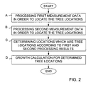
FIG. 2 is a flow chart of a first preferred embodiment of the invention. The method illustrated in FIG. 2 can be used to process three-dimensional measurement data obtained from the same area at two different moments of time. The collecting of data and the processing of the measurement data should be made exactly in the same way in order to obtain a result which is as reliable as possible. Thus, for instance, it is advantageous if the aircraft could fly over the measured area by using the same flight paths both times. The algorithms used for processing the collected measurement data should also be exactly the same both times.
The collected first and second measurement data is processed in blocks A and B. The processing is the same in both blocks, thus both the first and the second measurement data is in turns processed as will be explained in the following.
A Tree Height Model (THM) is created as the difference between a Digital Surface Model (DSM) representing the top of the tree crowns and the Digital Elevation Model (DEM) representing the ground. This starts by generating the Digital Elevation Model (DEM) from the collected measurement data, for instance as described in WO-publication 01/31290. In this solution, the area covered by the measurement data is divided into pixels of suitable size, for instance 50 cm×50 cm. The Digital Surface Model (DSM) of the crowns is obtained by taking the highest value of all hits with each pixel (50 cm) and interpolating the surface model for missing pixels. In order to generate the Digital Elevation Model (DEM) from laser scanner data, the points that reflected from non-ground objects, such as trees and buildings, must be removed from the measurements. This can be accomplished by combining the high resolution Digital Elevation Model (DEM), which is generated by finding the minima of all the laser measurements belonging to each pixel area, with a low resolution one for identification and removal of non-ground points. This combination can then be repeated as often as necessary to generate a Digital Elevation Model (DEM) of the desired resolution. The procedure starts with a coarse resolution. Iteratively, the resolution is improved until the desired resolution is reached and a rough ground surface is created.
The created surface is usually lower than a real surface because of the action of taking the minimum value for each DEM pixel, especially in hilly areas. Thus, a final refinement is performed to take return the original laser scanner data of the ground points and by comparing laser measurements with the corresponding values of the created surface and use the data in the final interpolation of DEM.
The created Tree Height Model (THM) can be used for locating tree locations. The positions (X, Y coordinates) of the local Z maximum values (Z value describing the height of a tree at coordinates X, Y) represent the locations of the tree locations. Preferably, the Tree Hight Model is low-pass filtered before the local maximum search in order to reduce the number of detected tree locations.
There are several methods to locate tree locations. Image processing techniques allow e.g. segmentation and crown delineation. With these knowledge you can calculate the center of the crown, the mass center of the crown and crown area. These techniques, also including morphological image analysis, are extensively reported in existing knowledge (books, scientific papers). In this new invention, all these techniques are applicable and do not change the basic novelty. All these techniques applied to distinguish tree locations are later on called as methods to locate the tree locations, for simplicity. The result is the tree locations according to the first measurement data (in block A) and the tree locations according to the second measurement data (in Block B).
In block C, a search is carried out in order to determine such locations which are tree locations according to the processing of both the first and the second measurement result. If one of the processing results indicates that a specific location is a tree location but the other processing result indicates that the specific location is not a tree location, no growth calculation is carried out for that location. This tree-to-tree matching helps to ensure that growth calculations are carried out only for such locations which according to both processing results are tree locations, in practice the tree locations of the same tree or group of trees.
The tree-to-tree matching can also be done with the help of crown areas. By overlaying the crown areas it is possible to calculate e.g. the distance between the mass centers of the crown area. This application assumes that the tree-to-tree matching by this mean is included in the used term “determining the locations which are tree locations according to both said first and second processing results”.
The tree-to-tree matching carried out in block C eliminates from the growth calculations, for instance, tree locations were trees have been cut or were trees have fallen between the occasions when the two measurement results were obtained.
Finally, in block D, the growth calculations are carried out for the locations which have been determined to be tree locations. The growth calculation can be executed by calculating the height difference extracted from the two Tree Height Models (THM) for the given location. If the goal is to calculate the average growth in a given area, it can be carried out by subtracting the average of heights obtained for the two measurement results for all matched tree locations.
The growth calculation can also be done in other ways. By using the image processing methods, e.g. segmentation to define the measured values or point clouds referring to each single tree (or group of trees), it is possible to compare the point clouds of the first and second measurement data. Since laser hits do not properly penetrate into crowns, the point cloud represents the profile of each tree. By overlaying the profiles corresponding the first and second measurement, it is possible to reliable estimate the systematic shift of the profiles, which is due to horizontal or vertical growth of the trees. Also, depending on the laser point density on the trees and homogeneity of the stands, other statistical features (e.g. mean, median, histogram) can lead to improved accuracy in height determination. The growth calculations can thus, for instance, be done by calculating the difference of profiles, by calculating the vertical or horizontal difference of tree height models or by calculating the difference between the means of laser points for said first and second measurement data.
Terrain elevations can be expected to be stable between the two occasions when the measurements were carried out. Therefore, the DEM created from two separate measurement results should result in the same elevation model. However, because Tree Height Model is the difference between the Digital Surface Model representing the top of the tree crowns and the Digital Elevation Model representing the ground, systematic errors will not show in the Tree Height Model, but random errors in DEM will propagate to Tree Height Model and therefore to the growth calculations. The effect of errors in DEM can be compensated in one of the measurement results as follows:
    • Systematic error of the two data sets can be determined for instance by measuring elevations of road surfaces. The measured difference can be compensated in one of the measurement results.
    • The DEM value and difference between the two measurement results can be calculated for each matched tree, and the growth can be compensated with the difference of the DEMs for each matched tree.
FIG. 3 is a flow chart of a second preferred embodiment of the invention. The solution of FIG. 3 can be used in the tree-to-tree matching described in connection with block C of FIG. 2.
In block C1, the location, which according to one of the processing results (in this example the first processing result) is a tree location, is selected.
In block C2, distance calculations are carried out in order to determine the minimum distance between the selected tree location and the location of the closest tree location according to the other processing result (in this example the second processing result).
In block C3, the calculated distance DISTANCE is compared to a predetermined limit LIMIT. If the distance is smaller than the limit, it is determined in block C4 that both processing results indicate that the location in question is a tree location. Otherwise it is determined in block C5 that the location in question is not a tree location.
The solution of FIG. 3 has the advantage that the effect of small positioning errors regarding the tree locations can be eliminated. Setting the limit value LIMIT at 0.5 m, for instance, makes it possible to detect a tree match (a tree location according to both processing results) at a specific location even though there is a positioning error of 0.5 m in the measurement data.
FIG. 4 is a flow chart of a third preferred embodiment of the invention. This embodiment makes it possible to minimize possible errors in the measurement of the growth at single tree locations when the average growth calculations are carried out. This improves the accuracy of the average calculations.
In block E a determined tree location is selected for comparison. Preferably, the process of FIG. 4 is repeated until all tree locations have been systematically processed according to the indicated steps.
In block F, the growth at the selected location is compared with at least one comparison value and in block G, a check is carried out to determine whether the comparison indicates an error. The object is to identify tree locations where the determined growth is unrealistic. The number of comparison values and the value of these comparison values are selected with this in mind. An alternative is to use a first comparison value=0, and to determine that an error exists for each tree location where the determined growth is equal to or less than zero. This is naturally a clear indication of an error, as it should not be possible that a tree becomes smaller by growth. A second comparison value can also be selected to identify tree locations where the growth exceeds what is assumed to be realistic when taking into account the time period between the collection of the first and the second measurement data. For instance, it can be assumed that an error exists if the determined growth at a tree location is more than 1 m when the time period is one year.
If it is determined in block G that the result of the comparison indicates an error, the tree location in question is not selected for average calculations but instead, a check to see whether all tree locations have already been processed is carried out in block I.
Finally, when all tree locations have been processed, block J is entered. In block J, an average growth is calculated for the tree locations selected for average calculations in block H.
FIG. 5 is a block diagram of an apparatus according to the present invention. The apparatus 7 of FIG. 5 can in practice consist of an ordinary Personal Computer (PC) programmed to carry out the growth calculations according to the method explained in connection with the previous FIGS. 2 to 4.
The apparatus 7 has an input 11 for receiving first three-dimensional measurement data DATA1 and second three-dimensional measurement data DATA2. The data and the program used for processing the data is stored in memory 9. The processing means 8 carry out the processing and output the result of the growth calculations to a display 10. Alternatively or in addition to the display the result can also be outputted to some other computer peripherals, such as to a printer or written to a file in a disk.
It is to be understood that the above description and the accompanying figures are only intended to illustrate the present invention. It will be obvious to those skilled in the art that the invention can be varied and modified also in other ways without departing from the scope and spirit of the invention disclosed in the attached claims.

Claims (9)

1. A method of determining the growth of trees comprising:
obtaining first measurement data at a first moment of time by utilizing a laser scanner located above the trees,
obtaining second measurement data at a second moment of time by utilizing a laser scanner located above the trees,
processing said first measurement data in order to determine the location of tree locations,
processing said second measurement data in order to determine the location of tree locations,
determining the locations which are tree locations according to both said first and second processing results, and
calculating the growth of trees at said determined locations by determining the difference in the size indicated by the second measurement data as compared to the size indicated by said first measurement data.
2. A method according to claim 1, wherein said determining of the locations which are tree locations according to the results of both said first and second processing is carried out by tree-to-tree matching involving:
selecting a location which according to one of said first and second processing results is a tree location,
calculating the distance from said selected location to the closest location which according to the other one of said first and second processing results is a tree location, and
determining that the result of both said first and second processing indicates said selected location is a tree location, if the calculated distance does not exceed a predetermined minimum distance.
3. A method according to claim 1, comprising estimating the average growth of trees in a specific area based on average growth calculated based on the calculated growth at a plurality of tree locations.
4. A method according to claim 1, wherein average growth is calculated by:
comparing the growth at a plurality of tree locations with at least one predetermined threshold value in order to identify tree locations where the growth is such that an error can be suspected, and
calculating said average growth without taking into account the growth at said identified tree locations.
5. A method according to claim 1, wherein growth calculation is carried out by calculating the difference in profile of the trees as indicated by a plurality of measurement values obtained from a tree location, or by calculating the vertical or horizontal difference of the trees as indicated by the measurement data.
6. A computer program for controlling a computer to:
receive first three-dimensional measurement data,
receive second three-dimensional measurement data,
process said first measurement data in order to determine the location of tree locations,
process said second measurement data in order to determine the location of tree locations,
determine the locations which are tree locations according to the results of both said first and second processing,
calculate the growth at said determined locations by determining the difference in the size indicated by the second measurement data as compared to the size indicated by said first measurement data, and
produce a result indicating at least said calculated growth.
7. A computer program according to claim 6, wherein said computer program is configured to control a computer to calculate average growth by:
comparing the growth at a plurality of tree locations with at least one predetermined threshold value in order to identify tree locations where the growth is such that an error can be suspected, and
calculating said average growth without taking into account the growth at said identified tree locations.
8. An apparatus for determining the growth of trees, said apparatus comprising:
an input for receiving first three-dimensional measurement data and second three-dimensional measurement data, and
processing means, said apparatus being arranged to:
process said first measurement data with said processing means in order to determine the location of tree locations,
process said second measurement data with said processing means in order to determine the location of tree locations,
determine the locations which are tree locations according to the results of both said first and second processing,
calculate the growth of trees at said determined locations with said processing means by determining the difference in the size indicated by the second measurement data as compared to the size indicated by said first measurement data, and
produce a result indicating at least said calculated growth.
9. An apparatus according to claim 8, wherein said apparatus is arranged to calculate average growth by:
comparing the growth at a plurality of tree locations with at least one predetermined threshold value in order to identify tree locations where the growth is such that an error can be suspected, and
calculating said average growth without taking into account the growth of at said identified tree locations.
US10/803,966 2003-03-31 2004-03-19 Method, apparatus and program for determining growth of trees Expired - Lifetime US7013235B2 (en)

Applications Claiming Priority (2)

Application Number Priority Date Filing Date Title
FI20030479 2003-03-31
FI20030479A FI117309B (en) 2003-03-31 2003-03-31 Procedure, device and program for determining the growth of trees

Publications (2)

Publication Number Publication Date
US20040236535A1 US20040236535A1 (en) 2004-11-25
US7013235B2 true US7013235B2 (en) 2006-03-14

Family

ID=8565897

Family Applications (1)

Application Number Title Priority Date Filing Date
US10/803,966 Expired - Lifetime US7013235B2 (en) 2003-03-31 2004-03-19 Method, apparatus and program for determining growth of trees

Country Status (3)

Country Link
US (1) US7013235B2 (en)
CA (1) CA2460089C (en)
FI (1) FI117309B (en)

Cited By (9)

* Cited by examiner, † Cited by third party
Publication number Priority date Publication date Assignee Title
WO2008033661A2 (en) * 2006-09-12 2008-03-20 Harris Corporation Geospatial modeling system providing simulated tree trunks for groups of tree crown vegitation points and related methods
EP2133822A1 (en) 2008-06-13 2009-12-16 University College Cork A method of stem taper, volume and product breakout prediction
US20100198775A1 (en) * 2009-12-17 2010-08-05 Adam Robert Rousselle Method and system for estimating vegetation growth relative to an object of interest
US20100205219A1 (en) * 2009-09-30 2010-08-12 Adam Robert Rousselle Method and system for locating a stem of a target tree
US8565958B1 (en) * 2011-06-02 2013-10-22 Google Inc. Removing extraneous objects from maps
US8680994B2 (en) 2010-12-30 2014-03-25 Utility Risk Management Corporation, Llc Method for locating vegetation having a potential to impact a structure
US11233591B1 (en) 2020-08-19 2022-01-25 FPL Smart Services, LLC Vegetation growth detection via radio propagation
US20220284605A1 (en) * 2021-03-05 2022-09-08 Intermap Technologies, Inc. Systems and methods for forest canopy height estimation
US11532093B2 (en) 2019-10-10 2022-12-20 Intermap Technologies, Inc. First floor height estimation from optical images

Families Citing this family (14)

* Cited by examiner, † Cited by third party
Publication number Priority date Publication date Assignee Title
FI117490B (en) * 2004-03-15 2006-10-31 Geodeettinen Laitos Procedure for defining attributes for tree stocks using a laser scanner, image information and interpretation of individual trees
US7944548B2 (en) * 2006-03-07 2011-05-17 Leica Geosystems Ag Increasing measurement rate in time of flight measurement apparatuses
US7639347B2 (en) * 2007-02-14 2009-12-29 Leica Geosystems Ag High-speed laser ranging system including a fiber laser
JP4378571B2 (en) * 2007-05-31 2009-12-09 Necシステムテクノロジー株式会社 MAP CHANGE DETECTION DEVICE, MAP CHANGE DETECTION METHOD, AND PROGRAM
US7650240B2 (en) * 2007-06-22 2010-01-19 Weyerhaeuser Nr Company Estimating an attribute value using spatial interpolation and masking zones
US7917346B2 (en) * 2008-02-19 2011-03-29 Harris Corporation Geospatial modeling system providing simulated tree trunks and branches for groups of tree crown vegetation points and related methods
US9063544B2 (en) * 2012-09-19 2015-06-23 The Boeing Company Aerial forest inventory system
CN103267516A (en) * 2013-02-27 2013-08-28 北京林业大学 Sample plot measuring technology by using digital camera as tool
GB2530104A (en) * 2014-09-15 2016-03-16 Point4Uk Ltd Vegetation catergorisation
SE1630035A1 (en) * 2016-02-26 2017-08-27 Katam Tech Ab Methods, devices and computer programs for positioning
CN109785352B (en) * 2018-12-21 2022-11-22 广东工业大学 Intelligent efficient airborne radar point cloud analysis method
CN112066919A (en) * 2020-09-11 2020-12-11 黑龙江省林业科学研究所 Method for accurately measuring growth of forest trees
CN116152256A (en) * 2023-04-21 2023-05-23 长沙能川信息科技有限公司 Tree growth simulation method, device, equipment and storage medium
CN117606448B (en) * 2023-11-29 2024-04-30 山东艺术学院 Real-time forest land measurement system based on camera video and application method thereof

Citations (4)

* Cited by examiner, † Cited by third party
Publication number Priority date Publication date Assignee Title
WO2001031290A2 (en) 1999-10-28 2001-05-03 Diware Oy Method for determination of forest stand attributes and a computer program to perform the method
WO2002071832A1 (en) 2001-03-14 2002-09-19 Air Logistics (Nz) Limited Method of assessing standing trees
DE10160179A1 (en) 2001-12-07 2003-07-31 Klaus Rudolf Halbritter Method for remote sensing of morphologically and structurally complex objects in an object space, particularly for acquisition of surface data for agricultural and forestry terrain for evaluation of biodiversity data
US20050087110A1 (en) * 2002-11-18 2005-04-28 Yoshikazu Kobayashi Reforestation project system and reforestation project program

Patent Citations (4)

* Cited by examiner, † Cited by third party
Publication number Priority date Publication date Assignee Title
WO2001031290A2 (en) 1999-10-28 2001-05-03 Diware Oy Method for determination of forest stand attributes and a computer program to perform the method
WO2002071832A1 (en) 2001-03-14 2002-09-19 Air Logistics (Nz) Limited Method of assessing standing trees
DE10160179A1 (en) 2001-12-07 2003-07-31 Klaus Rudolf Halbritter Method for remote sensing of morphologically and structurally complex objects in an object space, particularly for acquisition of surface data for agricultural and forestry terrain for evaluation of biodiversity data
US20050087110A1 (en) * 2002-11-18 2005-04-28 Yoshikazu Kobayashi Reforestation project system and reforestation project program

Cited By (13)

* Cited by examiner, † Cited by third party
Publication number Priority date Publication date Assignee Title
WO2008033661A3 (en) * 2006-09-12 2009-01-08 Harris Corp Geospatial modeling system providing simulated tree trunks for groups of tree crown vegitation points and related methods
WO2008033661A2 (en) * 2006-09-12 2008-03-20 Harris Corporation Geospatial modeling system providing simulated tree trunks for groups of tree crown vegitation points and related methods
EP2133822A1 (en) 2008-06-13 2009-12-16 University College Cork A method of stem taper, volume and product breakout prediction
US8275547B2 (en) 2009-09-30 2012-09-25 Utility Risk Management Corporation, Llc Method and system for locating a stem of a target tree
US20100205219A1 (en) * 2009-09-30 2010-08-12 Adam Robert Rousselle Method and system for locating a stem of a target tree
US8352410B2 (en) 2009-12-17 2013-01-08 Utility Risk Management Corporation, Llc Method and system for estimating vegetation growth relative to an object of interest
US20100198775A1 (en) * 2009-12-17 2010-08-05 Adam Robert Rousselle Method and system for estimating vegetation growth relative to an object of interest
US8680994B2 (en) 2010-12-30 2014-03-25 Utility Risk Management Corporation, Llc Method for locating vegetation having a potential to impact a structure
US8565958B1 (en) * 2011-06-02 2013-10-22 Google Inc. Removing extraneous objects from maps
US11532093B2 (en) 2019-10-10 2022-12-20 Intermap Technologies, Inc. First floor height estimation from optical images
US11233591B1 (en) 2020-08-19 2022-01-25 FPL Smart Services, LLC Vegetation growth detection via radio propagation
US20220284605A1 (en) * 2021-03-05 2022-09-08 Intermap Technologies, Inc. Systems and methods for forest canopy height estimation
US11551366B2 (en) * 2021-03-05 2023-01-10 Intermap Technologies, Inc. System and methods for correcting terrain elevations under forest canopy

Also Published As

Publication number Publication date
US20040236535A1 (en) 2004-11-25
FI20030479A (en) 2004-10-01
CA2460089A1 (en) 2004-09-30
FI117309B (en) 2006-08-31
FI20030479A0 (en) 2003-03-31
CA2460089C (en) 2008-12-02

Similar Documents

Publication Publication Date Title
US7013235B2 (en) Method, apparatus and program for determining growth of trees
Hyyppa et al. A segmentation-based method to retrieve stem volume estimates from 3-D tree height models produced by laser scanners
US6792684B1 (en) Method for determination of stand attributes and a computer program to perform the method
Maltamo et al. The accuracy of estimating individual tree variables with airborne laser scanning in a boreal nature reserve
Yu et al. Automatic detection of harvested trees and determination of forest growth using airborne laser scanning
Abellán et al. Terrestrial laser scanning of rock slope instabilities
Popescu et al. Seeing the trees in the forest
Baltsavias et al. Digital surface modelling by airborne laser scanning and digital photogrammetry for glacier monitoring
Mills et al. A geomatics data integration technique for coastal change monitoring
Barbarella et al. Monitoring of large landslides by Terrestrial Laser Scanning techniques: field data collection and processing
Takahashi et al. Estimating individual tree heights of sugi (Cryptomeria japonica D. Don) plantations in mountainous areas using small-footprint airborne LiDAR
US20220198749A1 (en) System and method for monitoring forest gap using lidar survey data
Barrand et al. Optimizing photogrammetric DEMs for glacier volume change assessment using laser-scanning derived ground-control points
JP2003344048A (en) System for processing forest information
Farid et al. Using airborne lidar to discern age classes of cottonwood trees in a riparian area
Takahashi et al. Predicting individual stem volumes of sugi (Cryptomeria japonica D. Don) plantations in mountainous areas using small-footprint airborne LiDAR
JP7386136B2 (en) Cloud height measurement device, measurement point determination method, and cloud type determination method
Maas The suitability of airborne laser scanner data for automatic 3D object reconstruction
Lewińska et al. Evaluation of structure-from-motion for analysis of small-scale glacier dynamics
JP4946072B2 (en) Treetop search method, apparatus and program
Ressl et al. Quality checking of ALS projects using statistics of strip differences
Wagner et al. Robust filtering of airborne laser scanner data for vegetation analysis
JP7123366B2 (en) Evaluation method for standing trees in a forest area and boundary survey method suitable for identifying the evaluation target area in this evaluation method
KR100741155B1 (en) System for extracting height data of tree using laser pulse and method therefor
Julge et al. Combining airborne and terrestrial laser scanning technologies for measuring complex structures

Legal Events

Date Code Title Description
AS Assignment

Owner name: GEODEETTINEN LAITOS, FINLAND

Free format text: ASSIGNMENT OF ASSIGNORS INTEREST;ASSIGNORS:HYYPPA, JUHA;YU, XIAOWEI;REEL/FRAME:015557/0413

Effective date: 20040526

STCF Information on status: patent grant

Free format text: PATENTED CASE

FEPP Fee payment procedure

Free format text: PAT HOLDER NO LONGER CLAIMS SMALL ENTITY STATUS, ENTITY STATUS SET TO UNDISCOUNTED (ORIGINAL EVENT CODE: STOL); ENTITY STATUS OF PATENT OWNER: LARGE ENTITY

FPAY Fee payment

Year of fee payment: 4

FPAY Fee payment

Year of fee payment: 8

MAFP Maintenance fee payment

Free format text: PAYMENT OF MAINTENANCE FEE, 12TH YEAR, LARGE ENTITY (ORIGINAL EVENT CODE: M1553)

Year of fee payment: 12