US6212474B1 - System and method for providing route guidance with a navigation application program - Google Patents
System and method for providing route guidance with a navigation application program Download PDFInfo
- Publication number
- US6212474B1 US6212474B1 US09/196,279 US19627998A US6212474B1 US 6212474 B1 US6212474 B1 US 6212474B1 US 19627998 A US19627998 A US 19627998A US 6212474 B1 US6212474 B1 US 6212474B1
- Authority
- US
- United States
- Prior art keywords
- maneuver
- data
- token
- tokens
- rules
- Prior art date
- Legal status (The legal status is an assumption and is not a legal conclusion. Google has not performed a legal analysis and makes no representation as to the accuracy of the status listed.)
- Expired - Lifetime
Links
Images


Classifications
-
- G—PHYSICS
- G01—MEASURING; TESTING
- G01C—MEASURING DISTANCES, LEVELS OR BEARINGS; SURVEYING; NAVIGATION; GYROSCOPIC INSTRUMENTS; PHOTOGRAMMETRY OR VIDEOGRAMMETRY
- G01C21/00—Navigation; Navigational instruments not provided for in groups G01C1/00 - G01C19/00
- G01C21/26—Navigation; Navigational instruments not provided for in groups G01C1/00 - G01C19/00 specially adapted for navigation in a road network
- G01C21/34—Route searching; Route guidance
- G01C21/36—Input/output arrangements for on-board computers
- G01C21/3626—Details of the output of route guidance instructions
- G01C21/3629—Guidance using speech or audio output, e.g. text-to-speech
Definitions
- the present invention relates to a system and method for providing route guidance information to an end-user of a navigation application program.
- Computer-based navigation application programs are available that provide end-users with various navigating functions and features. Some computer-based navigation application programs are included in navigation systems installed in vehicles, such as automobiles, trucks, buses, and so on. These in-vehicle systems can provide end-users, such as drivers of the vehicles in which the navigation systems are installed, with various navigating functions. For example, some navigation application programs are able to determine an optimum route to travel by roads between locations in a geographic region. Using input from an end-user, and optionally from equipment that can determine one's physical location (such as a GPS system), a navigation application program can examine various routes between two locations to determine an optimum route to travel from a starting location to a destination location in a geographic region.
- a navigation application program can examine various routes between two locations to determine an optimum route to travel from a starting location to a destination location in a geographic region.
- the navigation application program may then provide the end-user with information about the optimum route in the form of instructions that identify the maneuvers required to be taken by the end-user to travel from the starting location to the destination location.
- the instructions may take the form of visual and/or audio instructions that are provided along the way as the end-user is traveling the route.
- navigation application programs are also provided on various other kinds of computer hardware platforms and with other kinds of computer architectures.
- navigation application programs may be provided on personal computers, including desktop computers and portable computers.
- Computer-based navigation application programs may also be provided on networks, including wireless networks and the Internet.
- Computer-based navigation application programs may also be included on hand-held computer devices, such as personal digital assistants, telephones, pagers, and so on.
- computer-based navigation application programs may be included on special purpose electronic devices, such as personal navigation systems.
- the navigation application program uses geographic data.
- the geographic data may be in the form of one or more databases that include data that represent physical features in a geographic region.
- the geographic database may include data representing the roads and intersections in a geographic region and also may include information relating to the represented roads and intersections in the geographic region, such as turn restrictions at intersections, speed limits along the roads, street names of the various roads, address ranges along the roads, and so on.
- navigation application programs provide many important features, there continues to be room for improvements.
- One area in which there is room for improvement relates to providing meaningful maneuvering information to the end-user.
- a navigation application program provides maneuvering instructions to the end-user, it may be helpful to provide information about the names of the roads involved in the maneuver (e.g., “At the upcoming intersection with First Street, turn slightly to the right to stay on Main Street”).
- some roads are unnamed. Accordingly, in order to provide more meaningful maneuvering instructions that include more detail, it is necessary to take into account the availability, quality, and type of information which is available about the represented physical geographic features.
- Another example of an area in which there is room for improvement relates to providing maneuvering instructions in different languages. For example, one person driving a rental automobile with a navigation system may want to have audible maneuvering instructions provided in English. Another driver of the same rental automobile may want to have the navigation system provide audible maneuvering instructions in Spanish. Alternatively, another driver of the same rental automobile may want to have the maneuvering instructions provided by the navigation system as text in English with graphics on a display monitor. Therefore, it would be beneficial to be able to accommodate the preferences of each of these different drivers with the same navigation system in the same automobile while still providing maneuvering instructions that are detailed and meaningful.
- Another consideration relates to providing route guidance features on a navigation application program being run on a personal computer. If the end-user is running a navigation application from a personal computer, he/she may want to have the maneuvering instructions printed out or saved to a disk file for later use. In this situation, the maneuvering instructions need to be rendered and formatted appropriately for printing, or in a usable file format.
- the navigation application program is operated from a hand-held computing device, such as a personal digital assistant.
- the end-user may want to have the maneuvering instructions provided on a display screen of the device.
- the navigation application program is provided via a telephone, the end-user may want to have the maneuvering instructions provided audibly as a voice message or on a display screen of the telephone.
- a further area in which there is need for improvement relates to provision of a universal route guidance module or tool that can be readily used in a variety of different software and hardware environments and platforms without the need for extensive revisions and customizations.
- Maneuver data structures are formed that include data from a geographic database for each location along a route at which a maneuvering instruction is to be provided. These maneuver data structures are used to form a list of tokens.
- a token can be either a character string or a symbol that refers to another item of data, which can be either a character string, audio data, or graphics data.
- Maneuvering instructions are provided by explicating the tokens in the list of tokens. Explicating the tokens is done by providing all the data contained in or referred to by the tokens in the order specified in the list of tokens.
- the list of tokens is built by combining sequences of tokens formed for each maneuver data structure. Each of the sequences of tokens is formed from a respective output list formed by application of a rules set to the data in the maneuver data structure.
- the contents of an output list for a maneuver data structure can include symbols and keys. Symbols in an output list are used to form tokens which are included in the sequence of tokens formed for that maneuver data structure. Keys in an output list refer to data in the corresponding maneuver data structure and are expanded to form tokens which are included in the sequence of tokens formed for that maneuver data structure.
- FIG. 1 is a block diagram illustrating a navigation system.
- FIG. 2 is a block diagram illustrating components of the navigation application program of FIG. 1 .
- FIG. 3 is a diagram illustrating the components of the route calculation object of FIG. 2 .
- FIG. 4 is a diagram illustrating the components of the maneuver generation tool of FIG. 2 .
- FIG. 5 is a diagram illustrating the component members of one of the maneuver data structures of FIG. 4 .
- FIG. 6 is a diagram illustrating the components of the token generation object of FIG. 2 .
- FIG. 7 is a diagram illustrating components of the token generation configuration object of FIG. 2 .
- FIG. 8 is a diagram illustrating the components of one of the rules tables of FIG. 7 .
- FIG. 9 is a diagram illustrating components of one of the rules sets shown in FIG. 8 .
- FIG. 10 is a diagram illustrating expansion of keys into tokens by the expansion function shown in FIG. 7 .
- FIG. 11 is a diagram illustrating explication of the tokens in the token generation object by the explication tool shown in FIG. 2 .
- the navigation system 110 is a combination of hardware and software components.
- the hardware components of the navigation system 110 may include a processor 112 , memory 120 , and so on.
- the navigation system 110 may be stationary or portable. In the embodiment shown in FIG. 1, the navigation system 110 is a portable system located in a vehicle 111 , such as an automobile, truck, or bus. In other embodiments, the navigation system 110 may be installed in other platforms, as explained below.
- the navigation system 110 also includes a positioning system 124 that determines the position of the vehicle 111 in which it is installed.
- the positioning system 124 may include sensors 125 or other components that sense the speed, orientation, direction, and so on, of the vehicle 111 .
- the positioning system 124 may also include a GPS system.
- the navigation system 110 also includes a user interface 131 .
- the user interface 131 includes appropriate means 127 for receiving instructions and/or input from an end-user of the navigation system.
- the user interface 131 may include an input panel, keyboard, microphone, voice recognition software, and so on, through which the end-user may request navigation information.
- the user interface 131 also includes appropriate means 129 for providing information back to the end-user.
- the user interface 131 may include a display or speakers (including speech synthesis hardware and software) through which the end-user can be provided with information from the navigation system 110 .
- the processor 112 may be of any type used in navigation systems, such as 32-bit processors using a flat address space, such as a Hitachi SH1, an Intel 80386, an Intel 960, a Motorola 68020 (or other processors having similar or greater addressing space). Processor types other than these, as well as processors that may be developed in the future, are also suitable.
- the navigation system 110 uses geographic data 140 .
- the geographic data 140 may be stored in the vehicle 111 or alternatively, the geographic data 140 may be stored remotely and made available to the navigation system 110 in the vehicle 111 through a wireless communication system which may be part of the navigation system 110 .
- a portion of the geographic data 140 may be stored in the vehicle 111 and a portion of the geographic data 140 may be stored in a remote location and made available to the navigation system 110 in the vehicle 111 over a wireless communication system from the remote location.
- some or all of the geographic data 140 are stored on a medium 132 which is located in the vehicle 111 .
- the navigation system 110 includes a drive 114 (or other suitable peripheral device) into which the medium 132 can be installed and accessed.
- the storage medium 132 is a CD-ROM.
- the storage medium 132 may be a PCMCIA card in which case the drive 114 would be substituted with a PCMCIA slot.
- Various other storage media may be used, including fixed or hard disks, DVD disks or other currently available storage media, as well as storage media that may be developed in the future.
- the geographic data 140 may be in the form of one or more computer-readable data files or databases.
- the geographic data 140 includes information about the roads and intersections in or related to one or more geographic regions or coverage areas. This information includes data specifying the positions of the roads in the covered geographic region and also includes data about features relating to the roads, such as restrictions on directions of travel on the roads (e.g., one-way streets), turn restrictions, street addresses, street names, speed limits, and so on.
- the geographic data 140 may also include information about points of interest in the geographic area, such as hotels, restaurants, museums, stadiums, offices, automobile dealerships, auto repair shops, etc.
- the geographic data 140 may also include information about places, such as cities, towns, or other communities.
- the geographic database 140 may include other data about the geographic region.
- the geographic data 140 may take a variety of different forms.
- the geographic data 140 includes a plurality of road segment data entities.
- Each road segment data entity represents a portion (or segment) of a navigable road in the geographic region.
- Each physical road segment has two nodes associated with it, one at each of the endpoints of the road segment.
- the geographic data 140 also includes a plurality of data entities that represent these nodes.
- Each node data entity identifies the position (e.g., geographic coordinates) of one of the nodes at the end of a road segment.
- the geographic data are provided by Navigation Technologies Corporation of Sunnyvale, Calif., however it is understood that data developed and provided by other entities may also be suitable for use with the inventive subject matter disclosed herein.
- the navigation system 110 includes or uses navigation programming 118 .
- the navigation programming 118 includes the software that provides for the functions and/or features performed by the navigation system 110 .
- the navigation programming 118 uses the geographic data 140 in conjunction with input from the user interface 131 , and possibly in conjunction with outputs from the positioning system 124 , to provide various features and/or functions.
- the navigation programming 118 may be stored in a non-volatile storage medium 116 in the navigation system 110 .
- the navigation programming 118 and is the geographic data 140 may be stored together on a single storage device or medium.
- the navigation programming 118 may be located at a remote location and may be provided to or accessed by the navigation system 110 over a communications system.
- the navigation programming 118 may be formed of separate component applications (also referred to as programs, subprograms, routines, or tools).
- the component applications of the navigation programming 118 may work together through defined programming interfaces.
- FIG. 2 shows a block diagram illustrating some of the component applications for one embodiment of the navigation programming 118 included in the navigation system 110 of FIG. 1 .
- FIG. 2 shows only a portion of all the component applications that make up the navigation programming 118 .
- Other component applications, programs or tools may be included in the navigation programming 118 .
- the navigation programming 118 is shown to include a navigation application 210 and one or more navigation tools 212 .
- the navigation application 210 is a program or routine that provides for overall management of the functions of the navigation system 110 .
- the navigation application 210 may also include support for and interfaces to the navigation system hardware, such as the positioning system 124 and the user interface 131 .
- the navigation application 210 shown in FIG. 2 includes user interface functions 220 . These user interface functions 220 may provide for presenting a menu to the end-user on a screen display of the user interface hardware 131 , accepting inputs from the end-user via the user interface hardware 131 , displaying results to the end-user on a screen display of the user interface hardware 131 , and so on.
- the navigation tools 212 are programs that provide for specific navigation functions to the performed by the navigation programming 118 .
- the navigation tools 212 are programs that provide for functions that use the geographic data 140 .
- the features or functions provided by the navigation tools 212 may include route calculation, map display, route guidance, and other features.
- the navigation tools 212 receive requests for navigation information from the navigation application 210 .
- the navigation tools 212 request and obtain data from the geographic database 140 and use the data to satisfy the requests for navigation information from the navigation application 210 .
- the navigation tools 212 may obtain the geographic data directly from the geographic database 140 on the medium 132 or alternatively, the navigation tools 212 may obtain the data through an interface layer 213 and an operating system 214 .
- the navigation tools 212 are provided as modules that are relatively portable and that can be incorporated into different kinds of navigation programs, systems and/or platforms. Each navigation tool may be compiled together with the navigation application 210 and any other navigation tools to form a single executable program which is stored on the non-volatile medium 116 . Alternatively the navigation tools may be used as one or more standalone programs. In a preferred embodiment, the navigation tools employ an object-oriented approach to their programming, use of data, and relationship to the navigation application 210 . Each navigation tool is formed of one or more objects, each of which receives input data and generates output data according to a predefined function and each of which may invoke methods on other objects. In one present embodiment, each object has its own private memory that is opaque to other objects.
- an object may be used to convey data from one object to another object or may be used to transform data received as input.
- the navigation tools 212 are written in the C programming language although in alternative embodiments other programming languages may be used, such as C++, Java, Visual Basic, and so on.
- route calculation functions are performed by the route calculation tool 300 .
- the route calculation tool 300 determines a route between specified locations.
- the route calculation tool 300 receives input in the form of data that identify at least an origin and a desired destination.
- the route calculation tool 300 may receive additional input information that affects the calculation of the route.
- the input to the route calculation tool 300 may include data that specify user preferences such as avoidance of toll roads or expressways, and so on.
- the input may also include data that identifies the time of day at which the route will be started which may affect the route calculation.
- the route calculation tool 300 receives its input from the navigation application 210 .
- the user interface functions 220 receive input from the user interface 131 .
- the input may include a request from the end-user for a route to be calculated to a desired destination.
- the navigation application 210 may also receive information from the positioning system 124 indicating a position of the vehicle 111 .
- the information from the positioning system 124 is used by the navigation application 210 to determine a present position of the vehicle 111 .
- the end-user may specify a starting location for the route. Using these inputs, data that identity the locations of an origin and a destination are determined.
- This function may be provided by programming included in the navigation application 210 that then passes these data to the route calculation tool 300 .
- this function may be provided by another navigation tool, such as a geo-coding tool, which interfaces with the navigation application 210 and route calculation tool 300 .
- the route calculation tool 300 calculates a route between the origin and the destination.
- the route calculation tool 300 may use various means or algorithms for this purpose. Methods for calculating routes are disclosed in Ser. No. 09/047,698, filed Mar. 25, 1998, the entire disclosure of which is incorporated by reference herein. (The methods disclosed in the aforementioned patent application represent only some of the ways that routes can be calculated and the claimed subject matter of the present patent is not limited to any particular method of route calculation. Any suitable route calculation method now known or developed in the future may be employed.)
- the route calculation tool 300 provides an output.
- the output of the route calculation tool 300 is in form of a route calculation object 342 .
- FIG. 3 is a diagram representing the components of the route calculation object 342 .
- the route calculation object 342 contains an ordered list 344 identifying a plurality of road segment data entities (i.e., seg1, seg2, seg3 . . . seg(n)).
- the plurality of data entities represent the road segments that form the continuous navigable route between the origin and the destination that had been calculated by the route calculation tool 300 . Since these segments form a continuous route, each segment shares a node with its successor segment in the list. For example, as shown in FIG. 3, the segments “seg2” and “seg3” are shown to have a common node “N 3 .”
- the route calculation object 342 may include other information 346 in addition to the ordered list of road segment data entities.
- the route calculation object 342 which is created by the route calculation tool 300 , is used as an input to the route guidance tool 400 .
- the route guidance tool 400 uses the data in the route calculation object 342 , in conjunction with additional information from the geographic database 140 , to return navigation information to the navigation application 210 .
- the data returned by the route guidance tool 400 to the navigation application 210 may be sent directly to the user interface functions 220 for presentation to the end-user via the user interface hardware 131 .
- the data returned by the route guidance tool 400 to the navigation application 210 may be further processed by programming in the navigation application 210 .
- the presentation of information to the end-user via the user interface hardware 131 may be in the form of audible instructions, visual textual instructions, visual graphical instructions, or any combinations of these or other types of information presentation.
- the route guidance tool 400 is comprised of three navigation tools: a maneuver generation tool 500 , a token generator tool 600 , and an explication tool 700 .
- these navigation tools have the properties of tools, as described above.
- the maneuver generation tool 500 uses as its input the route calculation object 342 formed by the route calculation tool 300 .
- Methods for providing the functions performed by the maneuvering generation tool 500 are disclosed in the co-pending patent application, Ser. No. 08/893,201, filed Jul. 15, 1997, the entire disclosure of which is incorporated by reference herein.
- the maneuver generation tool describe herein is similar to the subject matter disclosed in the referenced application, except as noted below.
- the maneuver generation tool 500 performs at least two functions.
- the maneuver generation tool 500 uses the information in the ordered list of segment data entities 344 in the route calculation object 342 to determine which locations along the calculated route should be explicated to the end-user with a maneuvering or advisory instruction.
- the maneuver generation tool 500 collects information needed to provide a maneuvering or advisory instruction for the particular location.
- the maneuvering tool 500 uses two objects.
- the maneuver tool 500 includes a (maneuver generation) configuration object 530 and maneuver generation object 540 .
- the (maneuver generation) configuration object 530 contains maneuver rules 532 . These maneuver rules 532 are applied using the data in the route calculation object 342 and from the geographic database 140 . These rules determine when a location along the calculated route should be explicated with a maneuvering instruction.
- the route calculation object 342 contains the list 344 of data entities that represent segments of roads.
- each road segment represented by a data entity in the list 344 shares a node (i.e., an “endpoint”) with a road segment represented by an adjacent data entity in the list.
- the maneuver rules 532 are applied at each of these nodes in the list 344 .
- the direction of travel of the calculated route is taken into account.
- the segment by which the calculated route leads into the node being tested by the maneuver rules 532 is identified as the entry segment.
- the segment by which the calculated route leads out of the node being tested by the maneuver rules 532 is identified as the exit segment.
- all the other road segments that are not part of the calculated route, but that share this same node with the entry and exit segments are identified.
- the data entities that represent all these road segments are obtained from the database 140 .
- the maneuver rules 532 are provided in the form of a table 533 .
- the table 533 defines a plurality of maneuver types 534 and a plurality of maneuver condition tests 535 .
- Each of these maneuver types 534 characterizes a particular kind of roadway configuration change that can occur at the node being tested from the calculated route.
- Each maneuver type 534 is assigned a unique code or number.
- Each of the maneuver condition tests 535 is formulated to accept only a positive or negative answer.
- Each maneuver type 534 defined in the table 533 is associated with a unique subset of the plurality of maneuver condition tests 535 .
- Each maneuver condition test 535 uses the data in the data entities which had been obtained from the database 140 (such as the data associated with the entry segment, the exit segment, the accessible and inaccessible segments, and so on) to ascertain whether the condition specified in the maneuver condition test is satisfied. For each node in the calculated route 344 , if all the maneuver condition tests associated with a maneuver type 534 are satisfied, a maneuver instruction is required for that the node location.
- the maneuvering tool 500 For each of the locations determined by the maneuvering tool 500 as requiring explication, the maneuvering tool 500 forms a maneuver data structure 550 and adds the maneuver data structure to the maneuver generation object 540 .
- Each maneuver data structure 550 formed by the maneuver generation tool 500 contains the information needed to provide a maneuvering instruction to the end-user at the location along the route at which explication has been determined to be provided to the end-user.
- Some of the data required for the maneuver data structure is included in or derived from the segment data entities that were tested to determine whether a maneuvering instruction is required at the location of the node. Additional data may be required to be obtained or derived from the database 140 by the maneuver generation configuration object.
- FIG. 5 shows the kinds of data contained in each maneuver data structure 550 .
- the maneuver data structure 550 is formed as a C data structure.
- the maneuver generator object 540 collects data corresponding to the various members of the maneuver data structure 550 . Data are collected to the extent they are available. Members of the data structure may be left empty if there is no data available (e.g., if one of the roads at a maneuver location is unnamed).
- a field 550 (1)(1) that identifies the number of segments that meet at the node.
- the entry and exit segments 550 (1)(2), 550 (1)(3) into the node are identified.
- any accessible segments 550 (1)(4) that share the node are identified and any inaccessible segments 550 (1)(5) that share the node are identified.
- the data structure 550 For each of the segments (entry, exit, accessible, and inaccessible), the data structure 550 provides for identifying the segment database identification (a DBID) 550 (2)(1), the name(s) of the segment (if any) 550 (2)(2), sign(s) on the segment (if any) 550 (2)(3), the rank of the segment 550 (2)(4), the segment classification relative to the entry segment (exit, accessible, inaccessible) 550 (2)(5), the database classification of the segment (e.g., controlled access, street, ramp) 550 (2)(6), and the angle of the segment relative to the entry segment 550 (2)(8).
- a DBID segment database identification
- the data structure 550 also includes a field that can be used to identify the maneuver type (as described above) 550 (4)(2), the distance to the next maneuver 550 (4)(4), and whether the maneuver is included in a multiple maneuver 550 (4)(1).
- a multiple maneuver may be defined by the maneuver generator object when a location at which a maneuvering instruction is determined to be required is so close to an another adjacent location at which a maneuvering instruction is determined to be required that it may be preferable to present the two, or more, maneuver instructions to the end-user at the same time.
- the distance at which a multiple maneuver is defined is configurable and may be a function of various factors, including speed limits along the road segments, distance, rank, and so on.
- the data structure may also include fields for providing context information 550 (3) for the exit road. This kind of information may be useful when the other information in the maneuver structure is not sufficient to describe the exit fully, such as when the exit segment is unnamed.
- the fields for context information may include a destination string 550 (3)(1) which describes the exit of the maneuver in cases where the exit segment name is not sufficient (such as when it is unnamed).
- the context information 550 (3) may also include a field for a “location” 550 (3)(2) which gives the location of the exit relative to another road (e.g., before, after, ahead, behind, on the right, or on the left).
- the context information 550 (3) may also include a field for a “turn angle” 550 (3)(3) which gives the angle to be taken to go onto the exit road.
- the context information may also include a field for a “heading” 550 (3)(5) which can be used during the starting-off maneuver and provides the initial heading to be taken (e.g., north, south, east, west, northwest, etc.)
- the context information 550 (3) may also include a field for “relative to” 550 (3)(4).
- the “relative to” field 550 (3)(4) is meant to be used in a starting off maneuver.
- the “relative to” field 550 (3)(4) gives an initial intersection to be traveled toward. It can also used in cases where the exit segment is unnamed (e.g., “turn right after Main Street”).
- the context information 550 (3) may also include a field for “number of exits” 550 (3)(6) which can be used for roundabout maneuvers. This “number of exits” field 550 (3)(6) includes the number of exits to be passed traveling along a roundabout before reaching the desired exit.
- maneuver data structure 550 may include additional members 550 (5).
- the maneuver data structure also includes information for providing advisories.
- Advisories are types of useful explication information that are not necessarily associated with a maneuver. Advisories may be provided when there is a change in the road network, but a specific driving maneuver is not required. For example an advisory may be provided when entering or leaving a bridge or a tunnel.
- the maneuver data structure 550 includes a field that includes a listing 550 (4)(3) of one or more advisory types.
- the maneuver configuration object 530 in addition to the maneuver rules 532 which are used for determining whether to explicate a maneuver at a particular node and forming the data structures 550 therewith, the maneuver configuration object 530 also includes advisory rules 570 .
- the advisory rules 570 are applied to each of the nodes in the route calculation object 342 .
- the advisory rules 570 are in the form of a table 572 .
- the advisory rules table 572 includes a set of advisory types 576 and a set of advisory condition tests 578 .
- Each advisory type 576 characterizes a particular kind of advisory that can be provided at a node.
- Each advisory type 576 is assigned a unique code or number.
- Each of the advisory condition tests 578 is formulated so as to permit only positive and negative results.
- a unique subset of the advisory condition tests 578 is associated with each different advisory type 576 . If positive results are obtained for all the advisory condition tests associated with an advisory type 576 , that advisory type 576 is associated with the maneuver at that location.
- the rules for advisories do not require a unique result.
- the number or code for each advisory type 576 is included in the data structure 550 formed for that location.
- the application of the advisory rules is independent of the application of the maneuver rules. Thus, application of the advisory rules can require that an advisory instruction be provided at a location along a route even if the application of the maneuver rules at the same location does not require that a maneuvering instruction be provided. If application of the advisory rules requires that an advisory instruction be provided at a location, but application of the maneuver rules at the same location does not require that a maneuvering instruction be provided, a maneuver data structure is formed for that location containing data for the members of the data structure to the extent the data are available. A maneuver data structure formed for such a location would have a maneuver type of “0.”
- the maneuver generation configuration object 540 traverses the list 344 of data entities in the route calculation object 342 so that each node along the calculated route is tested with the maneuver rules 532 .
- a maneuver data structure 550 having information for each of the fields identified above (to the extent such information is available) is formed for each location in the calculated route at which the all the maneuver condition tests for any of the maneuver types or all the advisory condition tests for any of the advisory types are satisfied.
- the maneuver data structures 550 formed by this process are contained in order in the maneuver generation object 540 .
- the token generator tool 600 uses as its input the maneuver generation object 540 formed by the maneuver generation tool 500 .
- the token generator tool 600 includes a (token generator) configuration object 620 and a token generator object 650 .
- the token generator object 650 uses the information in the list of data structures 550 in the maneuver generation object 540 to form a token list.
- the token generator object 650 is used by the explication tool 700 (or one or more of the tools included therein) to form maneuvering instructions that are returned to the navigation application 210 in order to explicate the route calculated by the route calculation tool 300 to the end-user.
- FIG. 6 is a diagram illustrating the components of the token generator object 650 .
- the token generator object 650 contains a token list 652 .
- the token list 652 is comprised of an ordered sequence of tokens 655 .
- a token 655 is used to contain a fragment of the data from which is formed the maneuvering instruction to be explicated to the end-user.
- Tokens can be independent of the physical form (i.e., visual or audio) in which the maneuvering instructions are provided.
- tokens can be converted to either character data or graphics data (for visual display) or audio data (for audio playback).
- the tokens represent abstractions of the data units used for explication.
- Tokens can contain two types of data: symbols and character string data.
- Symbols are used to represent words and phrases (or graphics) that are commonly used when providing maneuvering instructions or when building meaningful grammatical constructions as part of maneuvering instructions. For example, symbols may be used for such words and phrases as “INTERSECTION”, “MERGE”, “TURN LEFT”, and so on.
- numbers are used for symbols, so that the number 00001 may be used to represent the word “INTERSECTION”, the number 00002 may be used to represent the word “MERGE”, the number 00003 may be used to represent the phrase “TURN LEFT”, and so on.
- Table 5 the second column includes the symbols and the first column includes the character text strings corresponding to the symbols.
- Symbols can map to audio data, character text string data, graphics data, or combinations of audio, character text string, and graphics data.
- the explication tools 700 described below, use this mapping capability to output data to the navigation application 210 . If the maneuvering instructions are going to be provided audibly, the audio data (files or portions thereof) mapped to by these symbols are returned by the explication tool 700 to the navigation application 210 and are played back by software in the navigation application 210 and hardware in the user interface 131 in order to hear the maneuvering instructions.
- the character text string data (or the graphics data) mapped to by these symbols are returned by the explication tool 700 to the navigation application 210 and are displayed on a video screen of the user interface 131 in order to see the maneuvering instructions.
- the explication tool 700 can return combinations of audio data, character string text data, and graphics data so that the maneuver instructions can be provided both audibly and visually.
- the third column includes a textual description of what is heard when the audio data corresponding to the symbol in the second column is played back.
- tokens can also contain character string data instead of symbols.
- Character string data may be included in tokens in order to provide more elaborate and/or meaningful maneuvering instructions.
- character string data may be used to add the names of geographic features (e.g., road names or point of interest names) to the maneuvering instructions in order to make the instructions more meaningful.
- audio data files or portions thereof in which the geographic name is rendered in speech may be unavailable. Therefore, a token for this kind of data contains a character string of the geographic feature name.
- This character string data may be obtained from the geographic database 140 that includes the names of geographic features. For example, the maneuvering instruction “TURN LEFT AT THE NEXT INTERSECTION” could be formed from tokens using only symbols.
- a more detailed maneuvering instruction could be provided using the name of the geographic feature involved in the maneuver: “TURN LEFT AT THE NEXT INTERSECTION INTO IRVING PARK ROAD.”
- the words “IRVING PARK ROAD” would be derived from a token that included the character string “IRVING PARK ROAD.”
- Tokens that contain character string data may be used to provide both audio and visual maneuvering instructions.
- text-to-speech software may be used.
- the token generator configuration object 620 contains the components used for generating the token generator object 650 . These components include configuration parameters and tables necessary for generating a list of tokens. Referring to FIG. 7, the token generator configuration object 620 includes one or more rules tables 630 . Each of these rules tables 630 may include rules that are tailored for a specific kind of explication. For example, one kind of rules table is a voice rules table 630 (V). The voice rules table 630 (V) is used to provide an output in the form of a token generator object 650 in which the tokens are arranged for providing meaningful audio maneuvering instructions. Another kind of rules table is a text rules table 630 (T).
- the text rules table 630 is used to provide an output in the form of a token generator object 650 in which the tokens are arranged for providing meaningful maneuvering instructions as text on a video display.
- Table 3 is an example of a rules table for generating tokens for visual display
- Table 4 is an example of a rules table for generating tokens for audio playback.
- both voice and text explication can be provided from the same token generator object produced by a generic rules table.
- Rules tables may be provided for explication in different languages. Rules tables are provided for different languages in order to account for the grammatical differences of different languages.
- the rules table for a language arranges the tokens in the token generator object 650 (from which the words and phrases in the maneuvering instructions are derived) in the proper sequence for correct grammatical constructions in the language in which the maneuvering instruction is being provided. For example, separate rules tables may be provided for English, French, Spanish, German, and so on.
- Alternate rules tables may also be provided. These alternate rules table may be used for producing special kinds of token generator objects. For example, if the navigation system has limited video display capabilities, an alternative rules table can be used that produces a token generator object in which the maneuvering instructions derived therefrom are appropriately limited.
- each of the rules tables 630 includes structured lists of cases, including tests, associated actions and outputs, that are applied to each of the ordered plurality of maneuver data structures 550 in the maneuver object 540 .
- the token generator object 650 uses the rules in one of the rules tables 630 to form an output list 631 .
- the contents of the output list 631 are converted in the token generator object 650 to an ordered token sequence 633 .
- the token sequences 633 generated from all the maneuver data structures 550 are used to build the token list 652 that is contained in the token generator object 650 .
- the token sequence 633 formed for that maneuver is added to the token generator object 650 . More specifically, the token sequence 633 formed for each maneuver data structure 550 is appended to the end of the partially formed list in the token generator object 650 that contains the tokens, if any, which had already been added from previously processed maneuvers. Once all the maneuvers data structures are processed, the token sequences 633 formed from all the maneuvers 550 form the complete token list 652 in the token generator object 650 .
- the route calculated by the route calculation tool 300 can be explicated. Explication is performed by converting the tokens in the token generator object 650 into the appropriate format requested by the navigation application 210 .
- explication involves obtaining the audio data (files or portions thereof), the text character strings, or the graphics data (files or portions thereof) to which the symbols are mapped.
- explication involves returning the character strings for textual maneuvering instructions or performing a text-to-speech conversion for audio maneuvering instructions.
- each of the rules tables 630 includes a plurality of rules sets 632 .
- the rules table 630 includes rules sets 632 for different combinations of maneuver types and advisory types that can be found in any of the maneuver data structures 550 .
- each maneuver data structure 550 includes members, 550 (4)(2) and 550 (4)(3), that identify a maneuver type and possibly one or more advisory types.
- the rules table 630 includes a rules set 632 for each maneuver type and each combination of maneuver type and advisory type. For example, in the rules table 630 shown in the FIG. 8, one rules set 632 MAN(0) is defined for maneuver type “0”, another rules set 632 MAN(1) is defined for maneuver type “1”, another rules set 632 MAN(2) is defined for maneuver type “2” and so on.
- each rule set 632 in the rules table 630 includes one or more cases 634 .
- each case is uniquely numbered, e.g., 1, 2, 3 . . . and so on.
- the cases 634 in each rules set 632 account for each situation that can occur in the maneuver data structure 550 that has that specific combination of maneuver type or advisory type.
- the cases 634 in each rules set 632 are ordered so that when the configuration object 620 applies the rules set 632 to a maneuver data structure 550 having a specified combination of maneuver type or advisory type, the first case 634 listed in the rules set 632 is applied first.
- Each maneuver data structure 550 is treated separately. Also, each maneuver data structure 550 is taken in the order in which it is contained in the maneuver generation object 540 . Only the rules sets 632 that include cases that match the specific maneuver type and advisory type in the maneuver data structure 550 are used.
- a rules set is defined for a maneuver type equal to “ ⁇ 1”. If a rules set has a “ ⁇ 1” in its maneuver type field, it is satisfied by any maneuver type. For example, a case that has a “ ⁇ 1” in the maneuver type field and an “8” in the advisory type field is applied to any maneuver data structure that has an advisory type of “8.” The maneuver data structure may have any maneuver type in its maneuver type field.
- a case that has a “ ⁇ 1” in the advisory type field is satisfied by any advisory type.
- a case has a “4” in the maneuver type field and a “ ⁇ 1” in the advisory type field, it is applied to any maneuver data structure that has a maneuver type of “4.”
- the maneuver data structure may have any advisory type. In this manner, cases for advisory types can be used for more than one maneuver type and cases for maneuver types can be used for more than one advisory type.
- a tests field 636 associated with each case 634 in each rules set 632 is a tests field 636 .
- the tests field 636 for each case 634 identifies one or more tests 637 , or the test field 636 may indicate that there are no tests associated with the case. (For example, the tests field 636 may indicate that no tests are required by the presence of a code, such as “ ⁇ 1” in the tests field.)
- the tests field 636 identifies each test 637 by a test ID.
- Each test 637 is formed so that the result of the test is either “pass” or “fail.” (In the sample token rules tables included at Tables 3 and 4 in the Appendix, the names of the tests instead of the test ID's are included in the tests fields for the sake of illustration.)
- Each test 637 for each case 634 is performed using the data in the associated maneuver data structure 550 .
- one of the tests 637 might check for the presence of a name in the name of exit segment field of the maneuver data structure.
- Another test might check for the presence of a name in the destination field of the maneuver data structure.
- the token generator tool 600 includes a number of default tests in the token generator object 650 . Additional tests may be defined and included by the navigation application program 210 . (The tests 637 are in the code base which makes up the token generator object 650 , or if tests are defined in the navigation application 210 , the tests 637 may be located there.
- the test ID's which make up the rules are in the token generator configuration object 620 .)
- each case 634 is also associated with each case 634 .
- the contents of the case output 643 can include a list of one or more keys 656 , symbols 668 , or strings 674 , or combinations thereof, or alternatively the case output 643 can be empty. Keys, symbols and strings are explained further below.
- the keys, symbols, and strings in the output list 631 are arranged in the case output in a manner that provides for a meaningful explication of all or part of the maneuver to be provided taking into account the kinds of information included in the maneuver data structure as determined by the tests that are performed for that case.
- the action field 638 of a case 634 is defined to have one of two values, “replace” or “append.” If all the tests 637 specified in the test field 636 of a case 634 are passed, the action listed in the action field 638 of the case is performed.
- the contents 645 of the case output 643 of the successful case are temporarily saved as a potential output list 631 for the maneuver while any tests associated with any further cases associated with the same maneuver are performed
- the case outputs do not show the actual numeric values of the symbols. Instead, the case outputs in the example Tables 3 and 4 show the equivalent textual character strings represented by the symbols. This is done for illustration purposes.) If all the tests 637 specified in the test field 636 associated with a case 634 are passed and the action field 638 indicates “replace”, any keys 656 , symbols 668 , or strings 674 already appended for that same maneuver by a previously performed case, if any, are replaced with the contents 645 of the successfully passed new case. The keys 656 , symbols 668 , or strings 674 of this successfully passed new case are temporarily saved as a potential output list 631 for the maneuver while any tests associated with any further cases associated with the same maneuver are performed.
- the tests field 636 of a case 634 may indicate that there are no tests associated with the case. This may be indicated by a “ ⁇ 1” in the tests field 636 . If there are no tests indicated in the tests field 636 , the tests field is treated as satisfied for the case and the action specified in the action field 638 is performed. Thus, the action specified in the action field 638 of a case 634 with no specified tests is always performed when that case is encountered for the maneuver.
- the next step performed is the step specified in the success path field 640 of the case.
- the success path field 640 may identify the next case to be performed (e.g., by case number) for that maneuver, or the success path field 640 may indicate that there are no more cases required to be performed for that maneuver. If the success path field 640 indicates another case is to be performed, the tests 637 specified in the tests field 636 of that new case are performed. This process continues in this manner until no more cases are indicated to be performed for that maneuver.
- the next step performed is the action specified in the fail path field 642 .
- the fail path field 642 identifies the next case to be performed for that maneuver, or the fail path field 642 may indicate that there are no more cases required to be performed for that maneuver.
- the contents of the output list 631 built for the maneuver include the combined contents of the case outputs 643 of all the successful cases (except for any which were replaced by subsequently performed cases requiring replacement instead of appending).
- case outputs 643 may contain keys, symbols, strings, or combinations thereof. These keys, symbols, and strings in the output list 631 are converted to tokens by the token generator object 650 . The order in which the symbols, keys, and strings are included in the output list generated for each maneuver is maintained in the ordered token sequence formed therefrom.
- FIGS. 8 and 10 show the contents of the maneuver output list 631 made up of keys, symbols, and strings. Each of these may be distinguished by appropriate characters.
- keys are encompassed by angle brackets ( ⁇ >) and strings are encompassed by parentheses (“ ”).
- An entry in an output list 631 that is encompassed by neither angle brackets nor parentheses is taken to be a symbol.
- Each key, symbol and string in the output list 631 forms a token which is added to the token generator object.
- Symbols 688 are used to represent those portions of the maneuvering instructions that give meaning to the end-user. For example, in the maneuvering instruction that displays the text “TURN RIGHT ON MICHIGAN AVENUE”, one or more symbols would have been included in the output list of the maneuver to represent the phrase “TURN RIGHT ON”. A key would be used in the output list of the maneuver to represent the phrase “MICHIGAN AVENUE.”
- the symbol in the output list 631 of the maneuver would have been included in a case output 631 added by of one of the successful cases performed for the maneuver.
- the case that added the case output that included this symbol might have included a test in its test field that checked whether the name of the road in the road name field for the segment data entity identified in the exit segment field was different than the name of the road in the road name field for the segment data entity identified in the exit segment field.
- the ordered token sequence 633 In forming the ordered token sequence 633 from a maneuver output list 631 , when symbols are encountered, they are formed into tokens. Each symbol in the maneuver output list is formed into one token in the ordered token sequence formed therefrom.
- the token generator tool allows developers to use the words and phrases that the symbols will represent instead of the actual numeric symbols.
- Keys are used to refer to data contained in the maneuver data structure.
- keys are relatively dynamic.
- Each maneuver data structure in the maneuver generation object may include different data and therefore, the maneuver data structure members to which the keys refer may change from one maneuver data structure to the next.
- a key would be used in the case output list to refer to the name of the exit segment (i.e., “MICHIGAN AVENUE”).
- the key might take the form:
- the ordered token sequence 633 from this maneuver output list 631 , when a key is encountered, the corresponding item of data included in the maneuver data structure is identified. This item of data is used to form the key. This key is then expanded into a token which is then added to the ordered token sequence 633 for that maneuver.
- the key in the output list 631 of the maneuver would have been included in a case output 631 added by one of the successful cases performed for this maneuver.
- the case that added the case output that included this key might have included a test in its test field that checked whether the maneuver data structure 550 included data in the road name field ( 550 (2)(2) in FIG. 5) for the segment data entity identified in the exit segment field ( 550 (1)(2) in FIG. 5 ).
- Each key has an associated expansion function 670 that is used to expand the key into a token, which is then included in the ordered token sequence 633 for that maneuver.
- An expansion function is associated with a key when it is defined.
- the expansion function 670 accounts for any kinds of formatting or style considerations that relate to forming a user-friendly instruction from the data from which the key was derived. (Like the tests 637 , the code for the expansion functions is located in the code base of the token generator object 650 . When expanding keys, the expansion functions use data, such as styles and member maps described below, which are located in the token generator configuration object 620 .)
- a maneuvering instruction might indicate a distance to the next maneuver.
- a key would be used for this purpose.
- the key might be included in the case output of a case that checks for the presence of data in the maneuver data structure field for the distance to the next maneuver (i.e., 550 (4)(4) in FIG. 5 ). If there is data in this field, the case output would be added to the maneuver output list 631 .
- the item of data referred to by the key would be a number (e.g., 1500) that indicates the distance to the next maneuver in meters.
- this information can be expressed.
- a distance of “1500 meters” can be expressed in English in the following different ways: “1.5 km”, “1 and a halfkm”, “1500 m”, “fifteen hundred meters”, “1 km 500 m”, and so on. Some of these ways may be preferable if the maneuver is being explicated audibly whereas other ways may be preferable if the maneuver is being explicated on a video display. In either case, it is preferable to make the explication of the maneuver consistent. There are similar considerations related to expressing the data referred to by the key in different languages.
- the token generator tool When expanding a key, the token generator tool provides for selecting how certain kinds of keys are expressed. Moreover, the token generator tool provides for making exceptions, as appropriate, in order to accommodate language idiosyncrasies.
- the token generator tool provides that a key can have a style code 692 associated with it. A style code is used in the key to define the way in which the value represented by the key is expressed. This style code is used by the expansion function when expanding the key.
- the token generator configuration object 620 includes one or more styles for expressing different kinds of information included in keys, such as distance, time, numbers, and so on. These styles are identified by style ID's, such as “1”, “2”, and so on.
- style ID's such as “1”, “2”, and so on.
- a style code can be attached to a key and is used to determine the way in which the value represented by the key is expressed. Use of a style is illustrated in the following example:
- a key is defined in a case output as ⁇ DISTANCE_FROM_ORIGIN:1>
- the value “1” following the colon is the style code.
- a style having an ID of 1 is defined as providing that the key be expressed as
- x is the value in the key DISTANCE_FROM_ORIGIN. If the value of the corresponding DISTANCE_FROM_ORIGIN member of the maneuver data structure is “7”, then the expansion function 670 forms a token from this key by adding the character string “meters” to a character string formed from the value of the DISTANCE_FROM_ORIGIN. The resultant character string
- the style code attached to the key is “2”. This style is defined in the token configuration object as
- the expansion function 670 forms a token from this key containing the character string as follows:
- Another factor to be considered when explicating certain kinds of keys relates to the number of decimal places to be included in a number or the number of characters to be included in a name. For example, when a key is used to express a distance to the next maneuver, the navigation system and the geographic database may have computer processing capability and accuracy to determine the distance to the next maneuver to 7 decimal places. However, for an end-user engaged in driving an automobile, this level of precision would likely be unnecessary.
- the expansion function 670 in the token generator tool 700 also provides for selecting the number of places to which certain kinds of keys are expressed. Moreover, the token generator tool provides for making exceptions, as appropriate, in order to accommodate idiosyncrasies.
- the token generator tool provides that a key can have a formatter associated with it.
- a formatter code 688 is used to define the number of decimal places to be used in expressing certain tokens that are represented by certain keys. Use of a formatter code is illustrated in the following example:
- the value after the % sign is the formatter code.
- This formatter code is used to format the key.
- the key expansion function uses this information in the formatter code when building the tokens. In this example, the distance to the next maneuver is limited to only two decimal places.
- the formatter code can also be used to truncate character names to a specified number of characters.
- the formatter code can be used in this manner to facilitate the display of certain long geographic names.
- the formatter function truncates the value in the keys to the number of characters specified in the formatter code.
- Still another factor relates to the expansion of other kinds of keys.
- Some kinds of keys are used to represent data that undergoes a translation or mapping when they are expanded from a value in the maneuver data structure to another value in the token.
- An example of a key of this kind includes the heading. It may be desired to provide a maneuvering instruction such as “HEAD NORTHWEST ON ROUTE 95” on a display screen.
- the word “NORTHWEST” in the maneuvering instruction is derived from a token, which included a symbol, which in turn was formed from a key for the heading for the maneuver in the maneuver data structure.
- a key for the heading (e.g., ⁇ CONTEXT_HEADING>) refers to the heading member in the maneuver data structure, ( 550 (3)(5) in FIG. 5 ).
- the heading may be expressed as a number. This number may be in the range of 0-255, for example, with 0 referring to due north and each of the other numbers (1-255) referring to a relative number of degrees in a clockwise direction therefrom.
- the expansion function provides for translating the form in which the heading is expressed in the key (e.g., 223) into a form which is included in a token, which then can be explicated as the word (e.g., “NORTHWEST”) in a maneuvering instruction.
- the expansion function 670 uses a member value map 680 .
- the member value map 680 does not associate the values that the keys can assume directly into character strings. Instead, the member value map 680 associates values of keys to symbols. These symbols are then formed into tokens. These symbols are used the same way as the symbols used to represent commonly used maneuvering instructions. Specifically, these symbols map to either characters strings for textual explication or audio data for audio explication.
- At least some members of the maneuver structure 550 have a maneuver data structure member ID.
- a set of value-to-token maps is associated with each of these maneuver structure member ID's.
- the member value map 680 provides for associating different symbols with different values in each field of the maneuver structure. Then, when a key is expanded for that member and that member has a member value defined for it in a member value map, a token is generated that includes the associated symbol.
- a set of member value maps can be defined for the maneuver data structure member ⁇ CONTEXT_HEADING>.
- the set can include 8 member values for the directions “north”, “south”, “east”, or “west”, “northeast”, etc. Associated with each of these member values is a numeric symbol, e.g. 1, 2, 3, 4, 5, etc.
- the expansion function uses the member value map 680 to look up the symbol for the value in the key and generates the appropriate token that includes the symbol.
- Using member values maps for certain kinds of keys helps make the token generator tool flexible and language independent. By expanding the key to a symbol, instead of a character string, the language independence and format (audio vs. video) independence is maintained.
- the symbol included in the token can be mapped to a character string, voice data, or graphics data in any chosen language by the explication tool 700 .
- the maneuver output list 631 may also include strings 674 .
- a string occurs in an output list 631 when a successful (and not replaced) case for that maneuver included the string in its case output.
- a string 674 is comprised of ordinary character data. Strings can be useful for textual guidance where the contents of the string are displayed visually on a display screen to the end user. When strings are converted to tokens, the string of character data forms the token, which is then included in the token list for that maneuver. Strings can also be used to include control characters used for formatting textual output. For example, a string consisting of a single blank space (e.g., “ ”) can be placed between a symbol 668 and a key 656 in an output list 631 . This string is converted into a token representing a single blank space. Then when the maneuver is visually displayed to the end-user on a display screen, a space will appear between text derived from the token containing the symbol and the text contained in the token expanded from the key.
- a single blank space e.g
- Strings may be used for other formatting, such as tabs, carriage returns, and so on.
- Conventional control characters may be used for this purpose.
- Strings may also be used for display of other textual data. Strings may also be used for explication of voice data using text-to-speech conversion software.
- maneuvering instructions about a calculated route can be provided to the end-user of a navigation application program.
- One way is to provide all the maneuvering instructions to the end-user at the same time.
- Another way is to provide maneuvering instructions to the end-user one at a time. This latter way may be used when the end-user is traveling the calculated route so that the maneuvering instruction is provided to the end-user at some time in advance of when the maneuver is required to be taken.
- the maneuvering instructions may be made more meaningful if they are organized into collections or presentations.
- a maneuvering instruction may be presented on a display screen to the driver that states: “TURN LEFT AT THE NEXT INTERSECTION AND TRAVEL 3 MILES.”
- a maneuvering instruction may be provided that states: “TURN LEFT AT THE NEXT INTERSECTION AND THEN IMMEDIATELY TURN RIGHT ONTO THE RAMP, THEN TRAVEL 3 MILES.”
- the maneuver generation tool would have produced separate maneuver data structures for the left turn at the intersection and the right turn onto the ramp, from the standpoint of the end-user, it may be more meaningful to be advised of both maneuvers at the same time. Therefore, when providing maneuvering instructions to an end-user it may be desirable to group more than one maneuver together when providing maneuvering instructions to an end-user it may be desirable to group more than one maneuver together when providing maneuvering instructions to an end-user it may be desirable to group more than one maneuver together when providing maneuvering instructions to an end-user it may be desirable to group more than one maneuver together when providing maneuvering instructions to an end-user it may be desirable
- a case in a rules set can check the distance-to-next-maneuver field of the maneuver data structure, and if it is not empty, include a case output that includes symbol(s) for the words or phrase “THE DISTANCE TO THE NEXT MANEUVER IS”, followed by a key that takes the value in the distance-to-next-maneuver field. Because this case may be used for many, if not most, maneuver types, it can be set up as a case that is performed after every maneuver. In this manner, this case does not have to be repeated in each rules set for each maneuver type. This case can be set up to be performed after each maneuver by assigning it a maneuver type (e.g., ⁇ 3), and providing that a case with maneuver type of ⁇ 3 be performed after each maneuver.
- a maneuver type e.g., ⁇ 3
- Rules can be set up in this manner. For example, for formatting purposes, it may be desired to insert line breaks or page breaks after a displayed maneuver. Rules that include cases can be set up for this purpose and these cases will be performed after each displayed maneuver. Another rule can be set up to be performed before each maneuver, for example to identify the maneuver by number or type.
- a rule can be set up to check for multiple maneuvers. This rule would include a case that checks the multiple maneuver flag 550 (4)(1) of the maneuver data structure (in FIG. 5) to determine whether it is part of a multiple maneuver. If it is, the formatting that separates one maneuver from the next are used only after the last of the series of multiple maneuvers. In this manner, maneuvers included in distinct maneuver data structures can be presented to the end-user at one time as combined maneuvers.
- the explication tool 700 uses the token generator object 650 to return data to the navigation application 210 to explicate the calculated route to the end-user.
- the kind of data returned by the explication tool 700 to the navigation application 210 may be configured to correspond to the hardware resources of the navigation system. Thus, if the navigation system supports only text instructions, then the kind of data returned by the explication tool 700 will include textual data, but not audio or graphic data.
- the navigation application 210 may request that data returned by the explication tool 700 correspond to a particular one or more of these kinds. This request by the navigation application 210 may be made at the time of a request for route calculation and guidance from the end-user.
- the explication tool 700 may be configurable with defaults by the navigation application 210 so that the same one or more kinds of explication (text, voice, or both) are returned.
- the explication tool 700 may be comprised of one or more tools.
- the explication tool 700 includes three tools: a voice guidance tool 800 , a text guidance tool 840 , and a graphics guidance tool 870 .
- the explication tool 700 may include additional tools or alternatively, the explication tool 700 may include fewer than these three tools, such as only one or two of these tools. The operation of these three explication tools is described below.
- the voice guidance tool 800 receives the token list included in the token generator object 650 from the token generator tool 600 .
- the voice guidance tool 800 is used in an embodiment that includes symbol audio data files 802 .
- These symbol audio data files 802 may be included in the geographic database 140 or alternatively, the symbol audio data files 802 may be included in another database or on another medium which is accessible to the voice guidance tool 800 .
- Each of these symbol audio data files 802 contains data that can be converted to sound. More specifically, each of these symbol audio data files 802 includes data that expresses a spoken word or phrase when played back using appropriate hardware and software in the navigation system.
- symbol audio data files 802 may be provided for the spoken words and phrases for “TURN”, “LEFT”, “STAY TO THE”, “INTERSECTION”, and so on.
- each token is taken in the order in which it is included in the token generation object 650 .
- tokens can be either symbols or strings.
- Each of the tokens that is a symbol maps to one or more of the symbol audio data files 802 .
- the voice guidance tool 800 looks up the appropriate symbol audio data file associated with the symbol. This index 808 may be included in the geographic database 140 or alternatively, the index 808 may be included in another database or on another medium that is accessible to the voice guidance tool 800 .
- the voice guidance tool 800 accesses the appropriate symbol audio file and returns it to the navigation application.
- the voice rules 630 (in FIG. 7) that form the tokens in the token generator object 650 arrange them in the proper sequence for voice explication. Therefore, when the voice generator tool 800 returns the audio data files 802 represented by the tokens to the navigation application 210 , the voice generator tool 800 maintains them in the order that corresponds in the tokens from which they were derived.
- tokens may also be strings.
- the voice guidance tool 800 can also process tokens that are strings. Strings may be used as tokens to express the names of streets, municipalities, points of interest, and so on.
- the strings that form tokens may be derived from the geographic database 140 which includes character string data for the names of streets, municipalities, points of interest, and so on. These strings may be derived from keys that reference members of the maneuver data structure. Strings that form tokens may also be defined in the case outputs in the rules tables in the token generator configuration object 620 . Tokens that are strings do not have symbol audio data files 802 associated with them. Therefore, a text-to-speech software program 812 may be used to generate an audio data file to express the string of data in the token.
- the text-to-speech software program 812 may be included as part of the voice guidance tool 800 or alternatively, the text-to-speech software program 812 may be included as part of the navigation application.
- the voice guidance tool 800 encounters a token that is string of data
- the text-to-speech software program 812 generates an audio data file from the string of character data contained in the token.
- the text-to-speech software program 812 may use techniques that are known in the art to perform this function.
- the voice guidance tool 800 arranges the audio data files generated by the text-to-speech software program 812 with the audio data files 802 obtained from the geographic database in order to maintain the sequence specified in the token generator object for the tokens.
- the voice guidance tool 800 does not include a text-to-speech software program.
- the token generator configuration object 620 is configured to use a set of voice rules 630 (V) that produces a token generator object 620 in which none of the tokens is a string.
- the voice rules 630 (V) generate case outputs that result in all the tokens being symbols for which symbol audio files 802 are available for explication by the voice guidance tool 800 .
- the explication tool 700 can also include the text guidance tool 840 .
- the text guidance tool 840 operates similarly to the voice guidance tool 800 .
- the text guidance tool 840 receives the token list included in the token generator object 650 .
- the text guidance tool 840 is used in an embodiment that includes symbol text data 842 .
- the symbol text data 842 may be included in the geographic database 140 or alternatively, the symbol text data files 842 may be included in another database or on another medium which is accessible to the text guidance tool 840 .
- the symbol text data 842 are included in a text guidance configuration object 847 which is part of the text guidance tool 840 .
- the symbol text data 842 contains character text that can be displayed as text, such as a word or phrase, using appropriate hardware and software.
- the symbol text data 842 may be provided for the words and phrases for “TURN”, “LEFT”, “STAY TO THE”, “INTERSECTION”, and so on.
- the text guidance tool 840 processes the tokens in the order in which they are included in the token generation object 650 .
- tokens can be either symbols or strings.
- Each of the tokens that is a symbol maps to one or more of symbol text data 842 .
- the text guidance tool 840 looks up the appropriate symbol text data file(s) 842 associated with the symbol in the token.
- This index 848 may be included in the geographic database 140 or alternatively, the index 848 may be included in another database or on another medium that is accessible to the text guidance tool 840 . In the embodiment shown in FIG. 11, the index 848 are included in the text guidance configuration object 847 which is part of the text guidance tool 840 .
- the text guidance tool 840 accesses the symbol text data 842 and returns them to the navigation application.
- the token generator tool 600 specifies an appropriate order for the tokens in the token generator object.
- the text guidance tool 840 maintains the text data from the symbol text data 842 in this same order
- the text guidance tool 840 also processes tokens that are strings. Strings are used to express names of streets, municipalities, points of interest, and so on. These names are included as data in the geographic database 140 and may be derived from keys that reference members of the maneuver data structure 550 .
- the text guidance tool 840 encounters a token that is string of data, it is arranged with the rest of the strings derived from the rest of the tokens. The order in which the tokens had been arranged in the token generator object is maintained.
- the text rules that form the tokens in the token generator object 650 arrange them in the proper sequence for text explication. Therefore, the text generator tool 842 returns the text data represented by tokens in the order in which the tokens are arranged in the token generator object.
- the explication tool 700 can also include the graphics guidance tool 870 .
- the graphics guidance tool 870 operates similarly to the voice guidance tool 800 and the text guidance tool 840 .
- the graphics guidance tool 870 receives the token list included in the token generator object 650 .
- the graphics guidance tool 870 is used in an embodiment of the geographic database 140 that includes symbol graphic data files 872 .
- symbol graphic data files 872 may be included in the geographic database 140 or alternatively, the symbol graphic data files 872 may be included in another database or on another medium which is accessible to the graphics guidance tool 870 .
- Each of these symbol graphic data files 872 contains graphical data that can be displayed on a visual computer display.
- these symbol graphic data files 872 may include a display for an intersection, a merge, a U-turn, a railroad crossing, and so on.
- the graphics guidance tool 870 processes the tokens in the order in which they are included in the token generation object 650 .
- tokens can be either symbols or strings.
- Each of the tokens that is a symbol maps to one or more of symbol graphic data files 872 .
- the graphics guidance tool 870 looks up the appropriate symbol graphic data files 872 associated with the symbol in the token. This index 878 may be included in the geographic database 140 or alternatively, the index 878 may be included in another database or on another medium that is accessible to the graphic guidance tool 870 .
- the graphic guidance tool 870 accesses the symbol graphic data files 872 and returns them to the navigation application 210 .
- the token generation tool 600 specifies an appropriate order for the tokens in the token generator object.
- the graphics guidance tool 870 maintains the data from the symbol graphic data files 872 in this same order
- the explication tool 700 may include more than one of the voice guidance tool 800 , the text guidance tool 840 and the graphics guidance tool 870 . If the explication tool 700 includes more than one of these tools, the route calculated by the route calculation tool can be explicated to the end-user in more than one format. For example, if the explication tools 700 include both the text guidance tool 840 and the voice guidance tool 800 , the route calculated by the route calculation tool can be explicated to the end-user with both audible and visual instructions.
- the audible instructions can be provided via appropriate hardware in the user interface 131 , such as a speaker, and the visual instructions can be provided by a display screen in the user interface 131 .
- Both the visual instructions and the audio instructions can be provided by the explication tool using the same token generator object generated by the token generator tool 600 .
- the visual instructions and the audio instructions can be provided by the explication tool using two separate token generator objects generated by the token generator tool 600 .
- the token generator tool uses one rules set for generating a first token generator object tailored for visual presentation and uses another rules set for generating a second token generator object tailored for audio presentation.
- the token generator object tailored for visual presentation can include more detail such as street names, etc., since the information needed to present this information is readily available in the geographic database.
- the token generator object tailored for audio presentation includes less detail and may omit tokens for street names, etc., thereby avoiding the need to provide for text-to-speech conversion software.
- the flexible design architecture of the token generator tool is that is can be modified, enhanced, augmented, and extended by a user.
- the user is not necessarily the ultimate end-user who might be an individual who actually uses the navigation application program in a navigation system. Instead, the user may be an intermediate customer who incorporates the token generator tool with other software and, in turn, sells a system or program that includes the token generator tool included with such other software to the ultimate end-user.
- the navigation application was described as being installed in a navigation system that was installed in a vehicle.
- the navigation application can be installed in other kinds of platforms, including personal computers, hand held computing devices, telephones, and so on.
- the navigation application can also be installed on a network and made available to a client on the network.
- some portions of the navigation application may be located locally and other portions of the navigation application may be located remotely.
- the network may be a wireless network.
- the navigation application, or portions thereof, can be made available over the Internet.
Abstract
Description


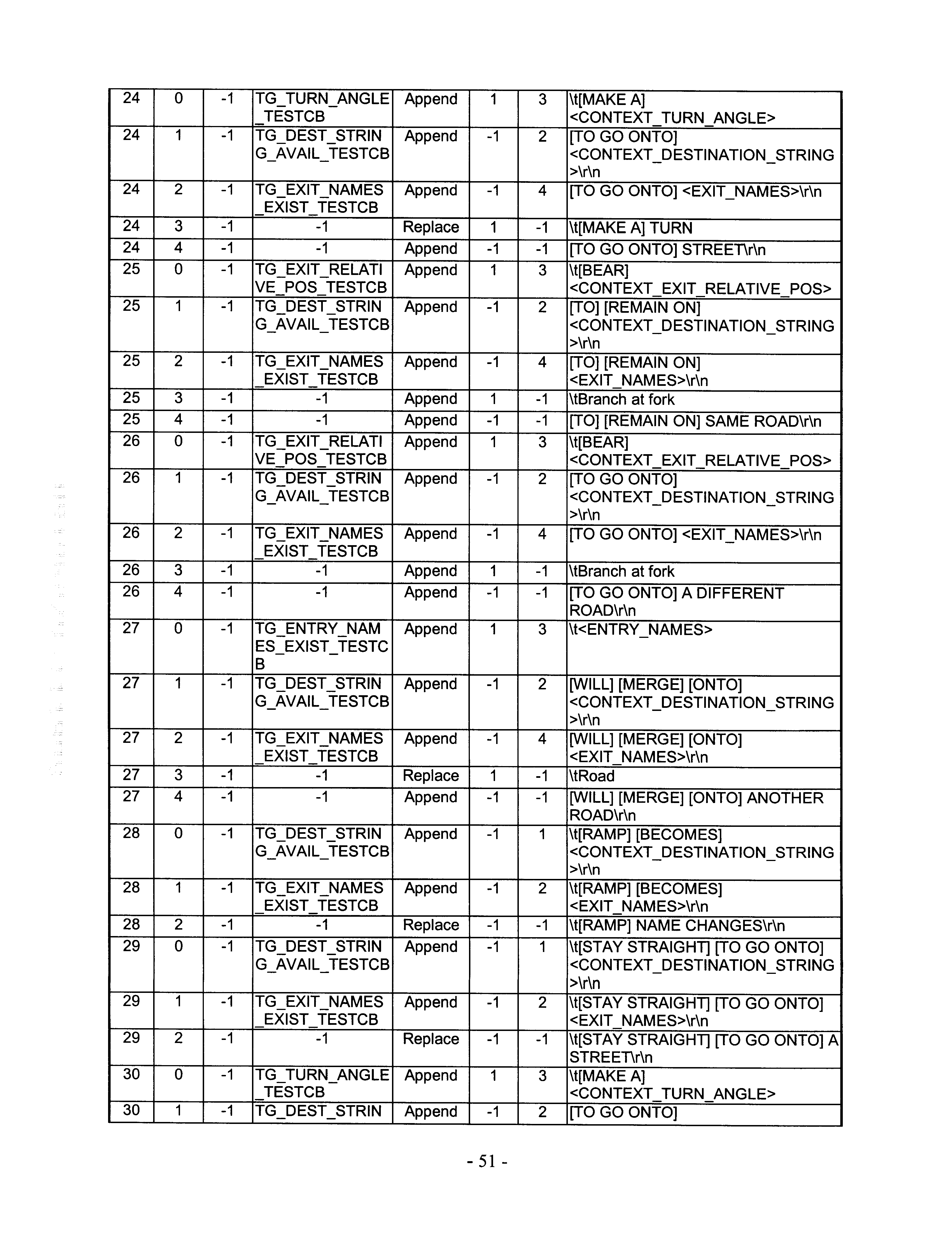


Claims (17)
Priority Applications (5)
| Application Number | Priority Date | Filing Date | Title |
|---|---|---|---|
| US09/196,279 US6212474B1 (en) | 1998-11-19 | 1998-11-19 | System and method for providing route guidance with a navigation application program |
| JP37810398A JP4268713B2 (en) | 1998-11-19 | 1998-12-18 | System and method for providing route guidance using a navigation application program |
| EP99306753A EP1003016B1 (en) | 1998-11-19 | 1999-08-25 | System and method for providing route guidance with a navigation application program |
| DE69933422T DE69933422T2 (en) | 1998-11-19 | 1999-08-25 | System and method for route guidance with a navigation application program |
| AT99306753T ATE341748T1 (en) | 1998-11-19 | 1999-08-25 | SYSTEM AND METHOD FOR ROUTE GUIDANCE USING A NAVIGATION APPLICATION PROGRAM |
Applications Claiming Priority (1)
| Application Number | Priority Date | Filing Date | Title |
|---|---|---|---|
| US09/196,279 US6212474B1 (en) | 1998-11-19 | 1998-11-19 | System and method for providing route guidance with a navigation application program |
Publications (1)
| Publication Number | Publication Date |
|---|---|
| US6212474B1 true US6212474B1 (en) | 2001-04-03 |
Family
ID=22724734
Family Applications (1)
| Application Number | Title | Priority Date | Filing Date |
|---|---|---|---|
| US09/196,279 Expired - Lifetime US6212474B1 (en) | 1998-11-19 | 1998-11-19 | System and method for providing route guidance with a navigation application program |
Country Status (5)
| Country | Link |
|---|---|
| US (1) | US6212474B1 (en) |
| EP (1) | EP1003016B1 (en) |
| JP (1) | JP4268713B2 (en) |
| AT (1) | ATE341748T1 (en) |
| DE (1) | DE69933422T2 (en) |
Cited By (73)
| Publication number | Priority date | Publication date | Assignee | Title |
|---|---|---|---|---|
| US20020004720A1 (en) * | 2000-05-02 | 2002-01-10 | Janoska Ian Zvonko | Personal monitoring system |
| US6363320B1 (en) * | 2000-08-18 | 2002-03-26 | Geospatial Technologies Inc. | Thin-client real-time interpretive object tracking system |
| US6385542B1 (en) * | 2000-10-18 | 2002-05-07 | Magellan Dis, Inc. | Multiple configurations for a vehicle navigation system |
| US20020055817A1 (en) * | 2000-08-18 | 2002-05-09 | Yue-Hong Chou | Real-time smart mobile device for location information processing |
| US6460046B1 (en) * | 1999-06-01 | 2002-10-01 | Navigation Technologies Corp. | Method and system for forming, storing and using sets of data values |
| US6473770B1 (en) | 1998-03-16 | 2002-10-29 | Navigation Technologies Corp. | Segment aggregation and interleaving of data types in a geographic database and methods for use thereof in a navigation application |
| US6487493B2 (en) * | 1999-11-30 | 2002-11-26 | Mitsubishi Denki Kabushiki Kaisha | Navigation device having a platform-dependent part and a user-interface-dependent part for supplying navigation services |
| US20020177476A1 (en) * | 2001-05-22 | 2002-11-28 | Chou Y. Hong | Durable global asset-tracking device and a method of using the same |
| US20020184236A1 (en) * | 2000-07-18 | 2002-12-05 | Max Donath | Real time high accuracy geospatial database for onboard intelligent vehicle applications |
| US6507850B1 (en) * | 1998-03-16 | 2003-01-14 | Navigation Technologies Corp. | Segment aggregation and interleaving of data types in a geographic database and methods for use thereof in a navigation application |
| US20030023614A1 (en) * | 2001-07-18 | 2003-01-30 | Newstrom Bryan J. | Populating geospatial database for onboard intelligent vehicle applications |
| US20030135383A1 (en) * | 2002-01-17 | 2003-07-17 | Fujitsu Limited | Travelable range calculation method and marketing support method |
| US6618650B1 (en) * | 1998-04-28 | 2003-09-09 | Honda Giken Kogyo Kabushiki Kaisha | Vehicle sharing system |
| US20040066376A1 (en) * | 2000-07-18 | 2004-04-08 | Max Donath | Mobility assist device |
| US20040107220A1 (en) * | 2001-04-19 | 2004-06-03 | Senthil Natesan | Navigation system with distributed computing architecture |
| US20040113772A1 (en) * | 2002-12-11 | 2004-06-17 | Y. Hong Chou | Method and apparatus for an automated location-based, dynamic notification system ( ALDNS) |
| US6839072B2 (en) | 2001-06-15 | 2005-01-04 | Koninklijke Philips Electronics N.V. | Method and system and article of manufacture for display of option recommendations through time-by-score |
| US20050149251A1 (en) * | 2000-07-18 | 2005-07-07 | University Of Minnesota | Real time high accuracy geospatial database for onboard intelligent vehicle applications |
| US20050174257A1 (en) * | 2002-03-05 | 2005-08-11 | The University Of Minnesota | Intersection assistance system and method |
| US20060069503A1 (en) * | 2004-09-24 | 2006-03-30 | Nokia Corporation | Displaying a map having a close known location |
| US20060129313A1 (en) * | 2004-12-14 | 2006-06-15 | Becker Craig H | System and method for driving directions based on non-map criteria |
| US20060287820A1 (en) * | 2002-10-10 | 2006-12-21 | Clifford Yamamoto | Host based satellite positioning systems |
| US20070073480A1 (en) * | 2005-09-23 | 2007-03-29 | Mona Singh | System and method for selecting and presenting a route to a user |
| US20070162223A1 (en) * | 2006-01-09 | 2007-07-12 | Thales Navigation, Inc. | Smart detour |
| US20070250515A1 (en) * | 2006-04-21 | 2007-10-25 | Lea David H | Method and system of securing content and destination of digital download via the internet |
| US20080027643A1 (en) * | 2006-07-28 | 2008-01-31 | Basir Otman A | Vehicle communication system with navigation |
| US20080051995A1 (en) * | 2006-08-25 | 2008-02-28 | Magellan Navigation, Inc. | Rerouting in Vehicle Navigation Systems |
| US20080139181A1 (en) * | 2006-12-08 | 2008-06-12 | Magellan Navigation, Inc. | Methods and apparatus for measuring the effectiveness of advertisements presented on a mobile navigation device |
| US20080172175A1 (en) * | 2007-01-16 | 2008-07-17 | Manju Chexal | Funny/humorous/abusive GPS system or navigation system |
| US20080198162A1 (en) * | 2007-02-16 | 2008-08-21 | Magellan Navigation, Inc. | A method of generating curved baseline for map labeling |
| US20080221787A1 (en) * | 2007-03-09 | 2008-09-11 | Magellan Navigation, Inc. | Methods and apparatus for determining a route having an estimated minimum fuel usage for a vehicle |
| US20080270468A1 (en) * | 2007-04-25 | 2008-10-30 | Magellan Navigation, Inc. | Adjusting spatial operations based on map density |
| US20090070293A1 (en) * | 2007-09-10 | 2009-03-12 | Magellan Navigation, Inc. | Nearest-Neighbor Geographic Search |
| US20090138190A1 (en) * | 2007-11-26 | 2009-05-28 | Magellan Navigation, Inc. | System and Method of Providing Traffic Data to a Mobile Device |
| US20090171584A1 (en) * | 2007-12-31 | 2009-07-02 | Magellan Navigation, Inc. | System and Method for Accessing a Navigation System |
| US20090182498A1 (en) * | 2008-01-11 | 2009-07-16 | Magellan Navigation, Inc. | Systems and Methods to Provide Navigational Assistance Using an Online Social Network |
| US20090187340A1 (en) * | 2008-01-18 | 2009-07-23 | Magellan Navigation, Inc. | Method and apparatus for hybrid routing using breadcrumb paths |
| US20090187342A1 (en) * | 2008-01-18 | 2009-07-23 | Magellan Navigation, Inc. | Method and apparatus for access point recording using a position device |
| US20090187341A1 (en) * | 2008-01-18 | 2009-07-23 | Magellan Navigation, Inc. | Method and apparatus to search for local parking |
| WO2009129775A1 (en) * | 2008-04-21 | 2009-10-29 | Navigon Ag | Method for operating an electronic assistance system |
| US20090318119A1 (en) * | 2008-06-19 | 2009-12-24 | Basir Otman A | Communication system with voice mail access and call by spelling functionality |
| US20100023204A1 (en) * | 2008-07-24 | 2010-01-28 | Basir Otman A | Power management system |
| US20100035631A1 (en) * | 2008-08-07 | 2010-02-11 | Magellan Navigation, Inc. | Systems and Methods to Record and Present a Trip |
| US20100049696A1 (en) * | 2008-08-20 | 2010-02-25 | Magellan Navigation, Inc. | Systems and Methods for Smart City Search |
| US20100076674A1 (en) * | 2008-09-22 | 2010-03-25 | Magellan Navigation, Inc. | Route Navigation via a Proximity Point |
| US20100100310A1 (en) * | 2006-12-20 | 2010-04-22 | Johnson Controls Technology Company | System and method for providing route calculation and information to a vehicle |
| US20100097239A1 (en) * | 2007-01-23 | 2010-04-22 | Campbell Douglas C | Mobile device gateway systems and methods |
| US20100144284A1 (en) * | 2008-12-04 | 2010-06-10 | Johnson Controls Technology Company | System and method for configuring a wireless control system of a vehicle using induction field communication |
| US20100161214A1 (en) * | 2006-04-14 | 2010-06-24 | Mona Singh | System And Method For Presenting A Computed Route |
| US20100305807A1 (en) * | 2009-05-28 | 2010-12-02 | Basir Otman A | Communication system with personal information management and remote vehicle monitoring and control features |
| US20100330975A1 (en) * | 2009-06-27 | 2010-12-30 | Basir Otman A | Vehicle internet radio interface |
| US20110121991A1 (en) * | 2009-11-25 | 2011-05-26 | Basir Otman A | Vehicle to vehicle chatting and communication system |
| US20110153266A1 (en) * | 2009-12-23 | 2011-06-23 | Regents Of The University Of Minnesota | Augmented vehicle location system |
| US20110184639A1 (en) * | 2010-01-27 | 2011-07-28 | Holsinger David J | Method of Operating a Navigation System to Provide Route Guidance |
| US20110238292A1 (en) * | 2010-03-29 | 2011-09-29 | Bresnahan Gregg A | Method of operating a navigation system |
| US8428871B1 (en) * | 2003-07-17 | 2013-04-23 | Mapquest, Inc. | Using routing symbols to describe a driving maneuver |
| US8447598B2 (en) | 2007-12-05 | 2013-05-21 | Johnson Controls Technology Company | Vehicle user interface systems and methods |
| US8554475B2 (en) | 2007-10-01 | 2013-10-08 | Mitac International Corporation | Static and dynamic contours |
| US8620532B2 (en) | 2009-03-25 | 2013-12-31 | Waldeck Technology, Llc | Passive crowd-sourced map updates and alternate route recommendations |
| US8634033B2 (en) | 2006-12-20 | 2014-01-21 | Johnson Controls Technology Company | Remote display reproduction system and method |
| US20140047364A1 (en) * | 2012-08-10 | 2014-02-13 | Nokia Corporation | Method and apparatus for determining representations of abbreviated terms for conveying navigation information |
| US20140121968A1 (en) * | 2012-10-30 | 2014-05-01 | Elektrobit Automotive Gmbh | Technique for the acoustic signalling of a navigation manoeuvre |
| US8856009B2 (en) | 2008-03-25 | 2014-10-07 | Intelligent Mechatronic Systems Inc. | Multi-participant, mixed-initiative voice interaction system |
| US20150304874A1 (en) * | 2012-09-28 | 2015-10-22 | Audi Ag | Method and system for determining a mobile communications network quality and downloading mobile communications data |
| US9812013B2 (en) | 1999-01-06 | 2017-11-07 | Infogation Corporation | Mobile navigation system operating with a remote server |
| US9930158B2 (en) | 2005-06-13 | 2018-03-27 | Ridetones, Inc. | Vehicle immersive communication system |
| US10175060B2 (en) | 2016-09-06 | 2019-01-08 | Microsoft Technology Licensing, Llc | Translation of verbal directions into a list of maneuvers |
| US20190113350A1 (en) * | 2017-10-12 | 2019-04-18 | Mitac International Corp. | Route-planning method and navigational system of converting route description into machine-readable predefined route |
| US10448209B2 (en) | 2001-10-04 | 2019-10-15 | Traxcell Technologies Llc | Wireless network and method with communications error trend analysis |
| US10801853B2 (en) * | 2016-07-25 | 2020-10-13 | Ford Global Technologies, Llc | Method and apparatus for upcoming turn identification and assistance |
| CN112368547A (en) * | 2018-11-02 | 2021-02-12 | 谷歌有限责任公司 | Context-aware navigation voice assistant |
| US11486717B1 (en) * | 2017-03-13 | 2022-11-01 | Mapbox, Inc. | Generating navigation instructions based on digital map context |
| CN112368547B (en) * | 2018-11-02 | 2024-04-30 | 谷歌有限责任公司 | Context-aware navigation voice assistant |
Families Citing this family (4)
| Publication number | Priority date | Publication date | Assignee | Title |
|---|---|---|---|---|
| US6487494B2 (en) * | 2001-03-29 | 2002-11-26 | Wingcast, Llc | System and method for reducing the amount of repetitive data sent by a server to a client for vehicle navigation |
| US7474960B1 (en) * | 2002-12-30 | 2009-01-06 | Mapquest, Inc. | Presenting a travel route |
| DE102007053213A1 (en) * | 2007-11-06 | 2009-05-07 | Navigon Ag | Method for operating a navigation system |
| EP2172745B1 (en) | 2008-10-02 | 2014-06-11 | Vodafone Holding GmbH | Providing information in a communication network |
Citations (11)
| Publication number | Priority date | Publication date | Assignee | Title |
|---|---|---|---|---|
| US5177685A (en) * | 1990-08-09 | 1993-01-05 | Massachusetts Institute Of Technology | Automobile navigation system using real time spoken driving instructions |
| US5181250A (en) | 1991-11-27 | 1993-01-19 | Motorola, Inc. | Natural language generation system for producing natural language instructions |
| US5283575A (en) * | 1991-11-08 | 1994-02-01 | Zexel Corporation | System and method for locating a travelling vehicle |
| JPH08159801A (en) * | 1994-12-08 | 1996-06-21 | Toshiba Corp | Navigation system |
| US5592665A (en) | 1993-10-04 | 1997-01-07 | U.S. Philips Corporation | Method and apparatus for fast accessing of data items from a sorted list for use with such method and/or apparatus |
| JPH0944791A (en) * | 1995-07-31 | 1997-02-14 | Honda Motor Co Ltd | On-vehicle navigation device |
| US5612882A (en) * | 1995-02-01 | 1997-03-18 | Lefebvre; Rebecca K. | Method and apparatus for providing navigation guidance |
| EP0838663A2 (en) | 1996-10-25 | 1998-04-29 | Navigation Technologies Corporation | System and method for storing geographic data on a physical storage medium |
| US5784691A (en) | 1995-07-26 | 1998-07-21 | U.S. Philips Corporation | RDS-TMC broadcast receiver |
| US5806035A (en) | 1995-05-17 | 1998-09-08 | U.S. Philips Corporation | Traffic information apparatus synthesizing voice messages by interpreting spoken element code type identifiers and codes in message representation |
| US5808566A (en) * | 1994-06-24 | 1998-09-15 | Navigation Technologies Corporation | Electronic navigation system and method |
-
1998
- 1998-11-19 US US09/196,279 patent/US6212474B1/en not_active Expired - Lifetime
- 1998-12-18 JP JP37810398A patent/JP4268713B2/en not_active Expired - Lifetime
-
1999
- 1999-08-25 DE DE69933422T patent/DE69933422T2/en not_active Expired - Lifetime
- 1999-08-25 AT AT99306753T patent/ATE341748T1/en not_active IP Right Cessation
- 1999-08-25 EP EP99306753A patent/EP1003016B1/en not_active Expired - Lifetime
Patent Citations (11)
| Publication number | Priority date | Publication date | Assignee | Title |
|---|---|---|---|---|
| US5177685A (en) * | 1990-08-09 | 1993-01-05 | Massachusetts Institute Of Technology | Automobile navigation system using real time spoken driving instructions |
| US5283575A (en) * | 1991-11-08 | 1994-02-01 | Zexel Corporation | System and method for locating a travelling vehicle |
| US5181250A (en) | 1991-11-27 | 1993-01-19 | Motorola, Inc. | Natural language generation system for producing natural language instructions |
| US5592665A (en) | 1993-10-04 | 1997-01-07 | U.S. Philips Corporation | Method and apparatus for fast accessing of data items from a sorted list for use with such method and/or apparatus |
| US5808566A (en) * | 1994-06-24 | 1998-09-15 | Navigation Technologies Corporation | Electronic navigation system and method |
| JPH08159801A (en) * | 1994-12-08 | 1996-06-21 | Toshiba Corp | Navigation system |
| US5612882A (en) * | 1995-02-01 | 1997-03-18 | Lefebvre; Rebecca K. | Method and apparatus for providing navigation guidance |
| US5806035A (en) | 1995-05-17 | 1998-09-08 | U.S. Philips Corporation | Traffic information apparatus synthesizing voice messages by interpreting spoken element code type identifiers and codes in message representation |
| US5784691A (en) | 1995-07-26 | 1998-07-21 | U.S. Philips Corporation | RDS-TMC broadcast receiver |
| JPH0944791A (en) * | 1995-07-31 | 1997-02-14 | Honda Motor Co Ltd | On-vehicle navigation device |
| EP0838663A2 (en) | 1996-10-25 | 1998-04-29 | Navigation Technologies Corporation | System and method for storing geographic data on a physical storage medium |
Non-Patent Citations (2)
| Title |
|---|
| Hoffman, Steve and Stewart, Charles, "Text-based Routing: An Affordable Way Ahead?", Proceedings of the IEEE-IEE Vehicle Navigation & Information System Conference, Ottawa, Canada-VNIS 1993. |
| Hoffman, Steve and Stewart, Charles, "Text-based Routing: An Affordable Way Ahead?", Proceedings of the IEEE-IEE Vehicle Navigation & Information System Conference, Ottawa, Canada—VNIS 1993. |
Cited By (138)
| Publication number | Priority date | Publication date | Assignee | Title |
|---|---|---|---|---|
| US6507850B1 (en) * | 1998-03-16 | 2003-01-14 | Navigation Technologies Corp. | Segment aggregation and interleaving of data types in a geographic database and methods for use thereof in a navigation application |
| US6473770B1 (en) | 1998-03-16 | 2002-10-29 | Navigation Technologies Corp. | Segment aggregation and interleaving of data types in a geographic database and methods for use thereof in a navigation application |
| US6618650B1 (en) * | 1998-04-28 | 2003-09-09 | Honda Giken Kogyo Kabushiki Kaisha | Vehicle sharing system |
| US9812013B2 (en) | 1999-01-06 | 2017-11-07 | Infogation Corporation | Mobile navigation system operating with a remote server |
| US7051035B2 (en) | 1999-06-01 | 2006-05-23 | Navteq North America, Llc | Method and system for forming, storing and using sets of data values |
| US6460046B1 (en) * | 1999-06-01 | 2002-10-01 | Navigation Technologies Corp. | Method and system for forming, storing and using sets of data values |
| US6487493B2 (en) * | 1999-11-30 | 2002-11-26 | Mitsubishi Denki Kabushiki Kaisha | Navigation device having a platform-dependent part and a user-interface-dependent part for supplying navigation services |
| US20020004720A1 (en) * | 2000-05-02 | 2002-01-10 | Janoska Ian Zvonko | Personal monitoring system |
| US20020184236A1 (en) * | 2000-07-18 | 2002-12-05 | Max Donath | Real time high accuracy geospatial database for onboard intelligent vehicle applications |
| US20050149251A1 (en) * | 2000-07-18 | 2005-07-07 | University Of Minnesota | Real time high accuracy geospatial database for onboard intelligent vehicle applications |
| US7072764B2 (en) | 2000-07-18 | 2006-07-04 | University Of Minnesota | Real time high accuracy geospatial database for onboard intelligent vehicle applications |
| US20040066376A1 (en) * | 2000-07-18 | 2004-04-08 | Max Donath | Mobility assist device |
| US6977630B1 (en) | 2000-07-18 | 2005-12-20 | University Of Minnesota | Mobility assist device |
| US20020055817A1 (en) * | 2000-08-18 | 2002-05-09 | Yue-Hong Chou | Real-time smart mobile device for location information processing |
| US6363320B1 (en) * | 2000-08-18 | 2002-03-26 | Geospatial Technologies Inc. | Thin-client real-time interpretive object tracking system |
| US7065446B2 (en) | 2000-08-18 | 2006-06-20 | Geospatial Technologies, Inc. | Real-time smart mobile device for location information processing |
| US6385542B1 (en) * | 2000-10-18 | 2002-05-07 | Magellan Dis, Inc. | Multiple configurations for a vehicle navigation system |
| US7801904B2 (en) * | 2001-04-19 | 2010-09-21 | Navteq North America, Llc | Navigation system with distributed computing architecture |
| US20040107220A1 (en) * | 2001-04-19 | 2004-06-03 | Senthil Natesan | Navigation system with distributed computing architecture |
| US7072668B2 (en) | 2001-05-22 | 2006-07-04 | Geospatial Technologies, Inc. | Durable global asset-tracking device and a method of using the same |
| US20020177476A1 (en) * | 2001-05-22 | 2002-11-28 | Chou Y. Hong | Durable global asset-tracking device and a method of using the same |
| US6839072B2 (en) | 2001-06-15 | 2005-01-04 | Koninklijke Philips Electronics N.V. | Method and system and article of manufacture for display of option recommendations through time-by-score |
| US20030023614A1 (en) * | 2001-07-18 | 2003-01-30 | Newstrom Bryan J. | Populating geospatial database for onboard intelligent vehicle applications |
| US7552008B2 (en) | 2001-07-18 | 2009-06-23 | Regents Of The University Of Minnesota | Populating geospatial database for onboard intelligent vehicle applications |
| US20030128182A1 (en) * | 2001-10-01 | 2003-07-10 | Max Donath | Virtual mirror |
| US7375728B2 (en) | 2001-10-01 | 2008-05-20 | University Of Minnesota | Virtual mirror |
| US10820147B2 (en) | 2001-10-04 | 2020-10-27 | Traxcell Technologies, LLC | Mobile wireless device providing off-line and on-line geographic navigation information |
| US11445328B2 (en) | 2001-10-04 | 2022-09-13 | Traxcell Technologies, LLC | Wireless network and method for suggesting corrective action and restricting communications in response to detecting communications errors |
| US10448209B2 (en) | 2001-10-04 | 2019-10-15 | Traxcell Technologies Llc | Wireless network and method with communications error trend analysis |
| US10701517B1 (en) | 2001-10-04 | 2020-06-30 | Traxcell Technologies Llc | Wireless network and method for suggesting corrective action based on performance and controlling access to location information |
| US10743135B2 (en) | 2001-10-04 | 2020-08-11 | Traxcell Technologies, LLC | Wireless network and method for suggesting corrective action in response to detecting communications errors |
| US20030135383A1 (en) * | 2002-01-17 | 2003-07-17 | Fujitsu Limited | Travelable range calculation method and marketing support method |
| US20050174257A1 (en) * | 2002-03-05 | 2005-08-11 | The University Of Minnesota | Intersection assistance system and method |
| US7209051B2 (en) | 2002-03-05 | 2007-04-24 | University Of Minnesota | Intersection assistance system and method |
| US20060287820A1 (en) * | 2002-10-10 | 2006-12-21 | Clifford Yamamoto | Host based satellite positioning systems |
| US20110029240A1 (en) * | 2002-10-10 | 2011-02-03 | Sirf Technology Inc. | Host based satellite positioning systems |
| US8954269B2 (en) * | 2002-10-10 | 2015-02-10 | Csr Technology Inc. | Host based satellite positioning systems |
| US7792639B2 (en) * | 2002-10-10 | 2010-09-07 | Sirf Technology Inc. | Host based satellite positioning systems |
| US7202801B2 (en) | 2002-12-11 | 2007-04-10 | Geospatial Technologies, Inc. | Method and apparatus for an automated location-based, dynamic notification system (ALDNS) |
| US20070024469A1 (en) * | 2002-12-11 | 2007-02-01 | Chou Y H | Method and apparatus for an automated location-based, dynamic notification system (ALDNS) |
| US20040113772A1 (en) * | 2002-12-11 | 2004-06-17 | Y. Hong Chou | Method and apparatus for an automated location-based, dynamic notification system ( ALDNS) |
| US8428871B1 (en) * | 2003-07-17 | 2013-04-23 | Mapquest, Inc. | Using routing symbols to describe a driving maneuver |
| US9322663B2 (en) | 2003-07-17 | 2016-04-26 | Mapquest, Inc. | Using routing symbols to describe a driving maneuver |
| US9696172B2 (en) | 2003-07-17 | 2017-07-04 | Mapquest, Inc. | Using routing symbols to describe a driving maneuver |
| US7480567B2 (en) * | 2004-09-24 | 2009-01-20 | Nokia Corporation | Displaying a map having a close known location |
| US20060069503A1 (en) * | 2004-09-24 | 2006-03-30 | Nokia Corporation | Displaying a map having a close known location |
| US20060129313A1 (en) * | 2004-12-14 | 2006-06-15 | Becker Craig H | System and method for driving directions based on non-map criteria |
| US9930158B2 (en) | 2005-06-13 | 2018-03-27 | Ridetones, Inc. | Vehicle immersive communication system |
| US20100152999A1 (en) * | 2005-09-23 | 2010-06-17 | Mona Singh | System And Method For Selecting And Presenting A Route To A User |
| US7698061B2 (en) * | 2005-09-23 | 2010-04-13 | Scenera Technologies, Llc | System and method for selecting and presenting a route to a user |
| US9366542B2 (en) | 2005-09-23 | 2016-06-14 | Scenera Technologies, Llc | System and method for selecting and presenting a route to a user |
| US7991544B2 (en) | 2005-09-23 | 2011-08-02 | Scenera Technologies, Llc | System and method for selecting and presenting a route to a user |
| US8589064B2 (en) | 2005-09-23 | 2013-11-19 | Scenera Technologies, Llc | System and method for selecting and presenting a route to a user |
| US20070073480A1 (en) * | 2005-09-23 | 2007-03-29 | Mona Singh | System and method for selecting and presenting a route to a user |
| US20070162223A1 (en) * | 2006-01-09 | 2007-07-12 | Thales Navigation, Inc. | Smart detour |
| US7590490B2 (en) | 2006-01-09 | 2009-09-15 | Mitac International Corporation | Smart detour |
| US8577598B2 (en) | 2006-04-14 | 2013-11-05 | Scenera Technologies, Llc | System and method for presenting a computed route |
| US9228850B2 (en) | 2006-04-14 | 2016-01-05 | Scenera Technologies, Llc | System and method for presenting a computed route |
| US20110172908A1 (en) * | 2006-04-14 | 2011-07-14 | Mona Singh | System And Method For Presenting A Computed Route |
| US20100161214A1 (en) * | 2006-04-14 | 2010-06-24 | Mona Singh | System And Method For Presenting A Computed Route |
| US7991548B2 (en) | 2006-04-14 | 2011-08-02 | Scenera Technologies, Llc | System and method for presenting a computed route |
| US20070250515A1 (en) * | 2006-04-21 | 2007-10-25 | Lea David H | Method and system of securing content and destination of digital download via the internet |
| US20080027643A1 (en) * | 2006-07-28 | 2008-01-31 | Basir Otman A | Vehicle communication system with navigation |
| US20190128689A1 (en) * | 2006-07-28 | 2019-05-02 | Ridetones, Inc. | Vehicle communication system with navigation |
| US9976865B2 (en) * | 2006-07-28 | 2018-05-22 | Ridetones, Inc. | Vehicle communication system with navigation |
| US11041735B2 (en) * | 2006-07-28 | 2021-06-22 | Value8 Co., Ltd. | Vehicle communication system with navigation |
| US20210278233A1 (en) * | 2006-07-28 | 2021-09-09 | Value8 Co., Ltd. | Vehicle communication system with navigation |
| US20080051995A1 (en) * | 2006-08-25 | 2008-02-28 | Magellan Navigation, Inc. | Rerouting in Vehicle Navigation Systems |
| US7945386B2 (en) | 2006-08-25 | 2011-05-17 | Mitac International Corporation | Rerouting in vehicle navigation systems |
| US20080139181A1 (en) * | 2006-12-08 | 2008-06-12 | Magellan Navigation, Inc. | Methods and apparatus for measuring the effectiveness of advertisements presented on a mobile navigation device |
| US20100100310A1 (en) * | 2006-12-20 | 2010-04-22 | Johnson Controls Technology Company | System and method for providing route calculation and information to a vehicle |
| US8634033B2 (en) | 2006-12-20 | 2014-01-21 | Johnson Controls Technology Company | Remote display reproduction system and method |
| US9430945B2 (en) * | 2006-12-20 | 2016-08-30 | Johnson Controls Technology Company | System and method for providing route calculation and information to a vehicle |
| US20080172175A1 (en) * | 2007-01-16 | 2008-07-17 | Manju Chexal | Funny/humorous/abusive GPS system or navigation system |
| US9587958B2 (en) | 2007-01-23 | 2017-03-07 | Visteon Global Technologies, Inc. | Mobile device gateway systems and methods |
| US20100097239A1 (en) * | 2007-01-23 | 2010-04-22 | Campbell Douglas C | Mobile device gateway systems and methods |
| US7692655B2 (en) | 2007-02-16 | 2010-04-06 | Mitac International Corporation | Apparatus and method of generating curved baseline for map labeling |
| US20080198162A1 (en) * | 2007-02-16 | 2008-08-21 | Magellan Navigation, Inc. | A method of generating curved baseline for map labeling |
| US20080221787A1 (en) * | 2007-03-09 | 2008-09-11 | Magellan Navigation, Inc. | Methods and apparatus for determining a route having an estimated minimum fuel usage for a vehicle |
| US7783417B2 (en) | 2007-03-09 | 2010-08-24 | Mitac International Corporation | Methods and apparatus for determining a route having an estimated minimum fuel usage for a vehicle |
| US20080270468A1 (en) * | 2007-04-25 | 2008-10-30 | Magellan Navigation, Inc. | Adjusting spatial operations based on map density |
| US8078641B2 (en) | 2007-04-25 | 2011-12-13 | Mitac International Corporation | Adjusting spatial operations based on map density |
| US20090070293A1 (en) * | 2007-09-10 | 2009-03-12 | Magellan Navigation, Inc. | Nearest-Neighbor Geographic Search |
| US7882102B2 (en) | 2007-09-10 | 2011-02-01 | Mitac International Corporation | Nearest-neighbor geographic search |
| US8554475B2 (en) | 2007-10-01 | 2013-10-08 | Mitac International Corporation | Static and dynamic contours |
| US20090138190A1 (en) * | 2007-11-26 | 2009-05-28 | Magellan Navigation, Inc. | System and Method of Providing Traffic Data to a Mobile Device |
| US8843066B2 (en) | 2007-12-05 | 2014-09-23 | Gentex Corporation | System and method for configuring a wireless control system of a vehicle using induction field communication |
| US8447598B2 (en) | 2007-12-05 | 2013-05-21 | Johnson Controls Technology Company | Vehicle user interface systems and methods |
| US20090171584A1 (en) * | 2007-12-31 | 2009-07-02 | Magellan Navigation, Inc. | System and Method for Accessing a Navigation System |
| US20090182498A1 (en) * | 2008-01-11 | 2009-07-16 | Magellan Navigation, Inc. | Systems and Methods to Provide Navigational Assistance Using an Online Social Network |
| US20090187340A1 (en) * | 2008-01-18 | 2009-07-23 | Magellan Navigation, Inc. | Method and apparatus for hybrid routing using breadcrumb paths |
| US8498808B2 (en) | 2008-01-18 | 2013-07-30 | Mitac International Corp. | Method and apparatus for hybrid routing using breadcrumb paths |
| US20090187342A1 (en) * | 2008-01-18 | 2009-07-23 | Magellan Navigation, Inc. | Method and apparatus for access point recording using a position device |
| US8290703B2 (en) | 2008-01-18 | 2012-10-16 | Mitac International Corporation | Method and apparatus for access point recording using a position device |
| US20090187341A1 (en) * | 2008-01-18 | 2009-07-23 | Magellan Navigation, Inc. | Method and apparatus to search for local parking |
| US8700314B2 (en) | 2008-01-18 | 2014-04-15 | Mitac International Corporation | Method and apparatus to search for local parking |
| US8856009B2 (en) | 2008-03-25 | 2014-10-07 | Intelligent Mechatronic Systems Inc. | Multi-participant, mixed-initiative voice interaction system |
| WO2009129775A1 (en) * | 2008-04-21 | 2009-10-29 | Navigon Ag | Method for operating an electronic assistance system |
| US8838075B2 (en) | 2008-06-19 | 2014-09-16 | Intelligent Mechatronic Systems Inc. | Communication system with voice mail access and call by spelling functionality |
| US20090318119A1 (en) * | 2008-06-19 | 2009-12-24 | Basir Otman A | Communication system with voice mail access and call by spelling functionality |
| US20100023204A1 (en) * | 2008-07-24 | 2010-01-28 | Basir Otman A | Power management system |
| US9652023B2 (en) | 2008-07-24 | 2017-05-16 | Intelligent Mechatronic Systems Inc. | Power management system |
| US20100035631A1 (en) * | 2008-08-07 | 2010-02-11 | Magellan Navigation, Inc. | Systems and Methods to Record and Present a Trip |
| US20100049696A1 (en) * | 2008-08-20 | 2010-02-25 | Magellan Navigation, Inc. | Systems and Methods for Smart City Search |
| US8249804B2 (en) | 2008-08-20 | 2012-08-21 | Mitac International Corporation | Systems and methods for smart city search |
| US8219317B2 (en) | 2008-09-22 | 2012-07-10 | Mitac International Corporation | Route navigation via a proximity point |
| US20100076674A1 (en) * | 2008-09-22 | 2010-03-25 | Magellan Navigation, Inc. | Route Navigation via a Proximity Point |
| US9324230B2 (en) | 2008-12-04 | 2016-04-26 | Gentex Corporation | System and method for configuring a wireless control system of a vehicle using induction field communication |
| US20100144284A1 (en) * | 2008-12-04 | 2010-06-10 | Johnson Controls Technology Company | System and method for configuring a wireless control system of a vehicle using induction field communication |
| US10045183B2 (en) | 2008-12-04 | 2018-08-07 | Gentex Corporation | System and method for configuring a wireless control system of a vehicle |
| US9140566B1 (en) | 2009-03-25 | 2015-09-22 | Waldeck Technology, Llc | Passive crowd-sourced map updates and alternative route recommendations |
| US8620532B2 (en) | 2009-03-25 | 2013-12-31 | Waldeck Technology, Llc | Passive crowd-sourced map updates and alternate route recommendations |
| US9410814B2 (en) | 2009-03-25 | 2016-08-09 | Waldeck Technology, Llc | Passive crowd-sourced map updates and alternate route recommendations |
| US20100305807A1 (en) * | 2009-05-28 | 2010-12-02 | Basir Otman A | Communication system with personal information management and remote vehicle monitoring and control features |
| US8577543B2 (en) | 2009-05-28 | 2013-11-05 | Intelligent Mechatronic Systems Inc. | Communication system with personal information management and remote vehicle monitoring and control features |
| US20100330975A1 (en) * | 2009-06-27 | 2010-12-30 | Basir Otman A | Vehicle internet radio interface |
| US9667726B2 (en) | 2009-06-27 | 2017-05-30 | Ridetones, Inc. | Vehicle internet radio interface |
| US9978272B2 (en) | 2009-11-25 | 2018-05-22 | Ridetones, Inc | Vehicle to vehicle chatting and communication system |
| US20110121991A1 (en) * | 2009-11-25 | 2011-05-26 | Basir Otman A | Vehicle to vehicle chatting and communication system |
| US20110153266A1 (en) * | 2009-12-23 | 2011-06-23 | Regents Of The University Of Minnesota | Augmented vehicle location system |
| US20110184639A1 (en) * | 2010-01-27 | 2011-07-28 | Holsinger David J | Method of Operating a Navigation System to Provide Route Guidance |
| US8374791B2 (en) * | 2010-01-27 | 2013-02-12 | Navteq B.V. | Method of operating a navigation system to provide route guidance |
| US20110238292A1 (en) * | 2010-03-29 | 2011-09-29 | Bresnahan Gregg A | Method of operating a navigation system |
| US9014960B2 (en) * | 2010-03-29 | 2015-04-21 | Here Global B.V. | Method of operating a navigation system |
| US20140047364A1 (en) * | 2012-08-10 | 2014-02-13 | Nokia Corporation | Method and apparatus for determining representations of abbreviated terms for conveying navigation information |
| US9069738B2 (en) * | 2012-08-10 | 2015-06-30 | Nokia Technologies Oy | Method and apparatus for determining representations of abbreviated terms for conveying navigation information |
| US10582402B2 (en) * | 2012-09-28 | 2020-03-03 | Audi Ag | Method and system for determining a mobile communications network quality and downloading mobile communications data |
| US20150304874A1 (en) * | 2012-09-28 | 2015-10-22 | Audi Ag | Method and system for determining a mobile communications network quality and downloading mobile communications data |
| US20140121968A1 (en) * | 2012-10-30 | 2014-05-01 | Elektrobit Automotive Gmbh | Technique for the acoustic signalling of a navigation manoeuvre |
| US11454508B2 (en) | 2016-07-25 | 2022-09-27 | Ford Global Technologies, Llc | Method and apparatus for upcoming turn identification and assistance |
| US10801853B2 (en) * | 2016-07-25 | 2020-10-13 | Ford Global Technologies, Llc | Method and apparatus for upcoming turn identification and assistance |
| US10175060B2 (en) | 2016-09-06 | 2019-01-08 | Microsoft Technology Licensing, Llc | Translation of verbal directions into a list of maneuvers |
| US11486717B1 (en) * | 2017-03-13 | 2022-11-01 | Mapbox, Inc. | Generating navigation instructions based on digital map context |
| US20190113350A1 (en) * | 2017-10-12 | 2019-04-18 | Mitac International Corp. | Route-planning method and navigational system of converting route description into machine-readable predefined route |
| US20210404833A1 (en) * | 2018-11-02 | 2021-12-30 | Google Llc | Context aware navigation voice assistant |
| CN112368547A (en) * | 2018-11-02 | 2021-02-12 | 谷歌有限责任公司 | Context-aware navigation voice assistant |
| US11725957B2 (en) * | 2018-11-02 | 2023-08-15 | Google Llc | Context aware navigation voice assistant |
| CN112368547B (en) * | 2018-11-02 | 2024-04-30 | 谷歌有限责任公司 | Context-aware navigation voice assistant |
Also Published As
| Publication number | Publication date |
|---|---|
| ATE341748T1 (en) | 2006-10-15 |
| DE69933422D1 (en) | 2006-11-16 |
| EP1003016B1 (en) | 2006-10-04 |
| DE69933422T2 (en) | 2007-05-03 |
| JP4268713B2 (en) | 2009-05-27 |
| EP1003016A2 (en) | 2000-05-24 |
| EP1003016A3 (en) | 2004-05-12 |
| JP2000221041A (en) | 2000-08-11 |
Similar Documents
| Publication | Publication Date | Title |
|---|---|---|
| US6212474B1 (en) | System and method for providing route guidance with a navigation application program | |
| EP1233407B1 (en) | Speech recognition with spatially built word list | |
| US6671615B1 (en) | Navigation system with sign assistance | |
| JP3573907B2 (en) | Speech synthesizer | |
| US6199013B1 (en) | Maneuver generation program and method | |
| US7533020B2 (en) | Method and apparatus for performing relational speech recognition | |
| JP3217754B2 (en) | Method and apparatus for indicating current vehicle position | |
| US6763301B2 (en) | Method and system for compact representation of routes | |
| US6751549B1 (en) | Method and system for route calculation that avoids railroad crossings | |
| US8374791B2 (en) | Method of operating a navigation system to provide route guidance | |
| US20010037203A1 (en) | Navigation system | |
| US20080077319A1 (en) | Navigation System Using Intersection Information | |
| KR20070097312A (en) | Storage and visualising points of interest in a navigation system | |
| JPH11230767A (en) | Method for access to map data for navigation | |
| US8065078B2 (en) | Conveying locations in spoken dialog systems | |
| US8401780B2 (en) | Method of prioritizing similar names of locations for use by a navigation system | |
| US6456935B1 (en) | Voice guidance intonation in a vehicle navigation system | |
| WO2010004612A1 (en) | Information processing apparatus, information generating apparatus, information processing method, information generation method, information processing program, information generating program, and recording medium | |
| EP1300655B1 (en) | Navigation system that supports multiple languages and formats | |
| US8521532B2 (en) | Speech-conversion processing apparatus and method | |
| JP4550207B2 (en) | Voice recognition device and voice recognition navigation device | |
| JPH0737199A (en) | Navigation system | |
| JPH02210600A (en) | Position input system for navigation device | |
| JPH04316200A (en) | Method for displaying road name in navigation device | |
| JP2002202792A (en) | On-vehicle navigation system and storage medium |
Legal Events
| Date | Code | Title | Description |
|---|---|---|---|
| AS | Assignment |
Owner name: NAVIGATION TECHNOLOGIES CORPORATION, ILLINOIS Free format text: ASSIGNMENT OF ASSIGNORS INTEREST;ASSIGNORS:FOWLER, ANDREW;MITTAL, ANKUR;REEL/FRAME:009603/0558 Effective date: 19981117 |
|
| STCF | Information on status: patent grant |
Free format text: PATENTED CASE |
|
| FPAY | Fee payment |
Year of fee payment: 4 |
|
| AS | Assignment |
Owner name: NAVTEQ CORPORATION, ILLINOIS Free format text: ASSIGNMENT OF ASSIGNORS INTEREST;ASSIGNOR:NAVIGATION TECHNOLOGIES CORPORATION;REEL/FRAME:015293/0400 Effective date: 20040203 Owner name: NAVTEQ NORTH AMERICA LLC, ILLINOIS Free format text: ASSIGNMENT OF ASSIGNORS INTEREST;ASSIGNOR:NAVTEQ CORPORATION;REEL/FRAME:015286/0504 Effective date: 20040510 Owner name: NAVTEQ NORTH AMERICA LLC,ILLINOIS Free format text: ASSIGNMENT OF ASSIGNORS INTEREST;ASSIGNOR:NAVTEQ CORPORATION;REEL/FRAME:015286/0504 Effective date: 20040510 Owner name: NAVTEQ CORPORATION,ILLINOIS Free format text: ASSIGNMENT OF ASSIGNORS INTEREST;ASSIGNOR:NAVIGATION TECHNOLOGIES CORPORATION;REEL/FRAME:015293/0400 Effective date: 20040203 |
|
| FPAY | Fee payment |
Year of fee payment: 8 |
|
| AS | Assignment |
Owner name: NAVTEQ B.V., NETHERLANDS Free format text: ASSIGNMENT OF ASSIGNORS INTEREST;ASSIGNOR:NAVTEQ NORTH AMERICA, LLC;REEL/FRAME:027588/0051 Effective date: 20111229 |
|
| FPAY | Fee payment |
Year of fee payment: 12 |
|
| AS | Assignment |
Owner name: HERE GLOBAL B.V., NETHERLANDS Free format text: CHANGE OF NAME;ASSIGNOR:NAVTEQ B.V.;REEL/FRAME:033830/0681 Effective date: 20130423 |