TECHNOLOGICAL FIELD
Example embodiments relate generally to navigation systems and more particularly relate to bloom filter enabled information exchange between a data service and a client device for requesting traffic data of a geographic region in a map version agnostic manner.
BACKGROUND
Generally, a client may submit a request for traffic data associated with a map region to a server and the server may process the traffic data request to provide the traffic data for the map region. Names or identifiers (IDs) may be used by the server to represent road segments associated with the map region. Problems may arise in generating the traffic data using the IDs of the road segments when the client is not operating with a most recent map version. For example, an older map version installed on the client may not include up-to-date road segments and traffic data associated with the road segments which is otherwise present in the most recent map version of the server. In such cases, the server needs to maintain multiple map versions, to provide identifiable traffic data. However, this approach is problematic as a limited number of map versions may be stored within a finite amount of server space. Performance and maintenance issues may also exist due to the storage of a large number of map versions. Additionally, this approach may not allow for rapid refreshing (e.g., weekly/daily updates) of the map stored on the server.
BRIEF SUMMARY OF SOME EXAMPLE EMBODIMENTS
Various embodiments provide for requesting and generating traffic data of a geographic region in a map version agnostic manner. As used herein, map version agnostic information/data is map information/data that is independent of a particular version of the digital map. For example, map version agnostic information/data is map information/data that is not expected to change between a first version of the digital map and a second version of the digital map. As used herein, a digital map is map content of world in a form of image data. In various embodiments, the map content may include map features such as physical features on the ground (e.g., roads, buildings, and the like). Various embodiments provide for the transmission of the traffic data in a bandwidth efficient manner. In various embodiments, the traffic data correspond to up-to-date traffic data of the geographic region. For example, the up-to date traffic data is the traffic data associated with most recent version of the digital map. Various embodiments provide for encoding one or more traffic ranges using map version agnostic identifiers that are encoded into one or more bloom filters, such that the encoded one or more traffic speed ranges may be transmitted as a bit array.
In an embodiment, when the digital map is partitioned in two dimensions (in a gridded form), each cell of the grid may indicate a map area. In an embodiment, a shape of the cell may be a square, a rectangular, a pentagonal, a tile of a tessellation, or the like. The cell may cover a portion of geographical region (e.g., an area) of the digital map. Accordingly, the cell of the grid is coined to be the map area. In various embodiments, each map area may be identified by a unique map area identifier (also referred to as “map area ID”). In some example embodiments, the map area may indicate a current area visible on a screen of the client. In an example embodiment, the map area comprises road segments. Generating the traffic data for the road segments of the map area may include three steps: (i) transmission of a traffic data update request for at least one map area, from a client to a data service; (ii) generation of encoded traffic data for the at least one map area in the data service and transmission of the encoded traffic data in a bandwidth efficient manner from the data service to the client; and (iii) decoding the received encoded traffic data in a map version agnostic manner.
In various embodiments, the client may have a client version of a digital map stored in memory of the client. For example, the client version of the digital map may be obtained from a mapping platform and stored in memory of the client. The client may transmit the traffic data request for at least one map area identifier (ID). In an example embodiment, the traffic data request is a request for up-to-date speed data (e.g., historical traffic patterns, real-time speed information from other vehicles traversing the road segments, or a combination of both, sometimes referred to as speed predictions) associated with the road segments of the map area ID. Additionally, the client may also transmit a traffic resolution value/parameter of the map area ID. The traffic resolution value of the map area ID may correspond to a number, where the number indicates a number of ranges the traffic data of the road segments has to be grouped into.
In various embodiments, the data service may have a data service version of the digital map stored in memory of the data service. For example, the data service version of the digital map may be the most recent version of the digital map. In various situations, the client version and the data service version may be different versions of the digital map. The data service may receive the traffic data request for the map area ID transmitted by the client. The data service may determine a data service version of traffic data, using the data service version of the digital map, for each road segment of the received map area ID.
Further, the data service may determine first road segments among the road segments of the map area ID, where the first road segments are the road segments that contain traffic data. The data service may generate a road segment identifier for each of the first road segments. In an example embodiment, the data service may determine map version agnostic identifiers to generate the road segment identifiers. In various embodiments, a map version agnostic identifier of a road segment may be a particular element and/or particular combination of elements of map version agnostic information corresponding to the road segment. According to some example embodiments, the map version agnostic information may include a name of the road segment, a length of the road segment, a travel direction of the road segment, a functional class of the road segment, speed limit of the road segment, midpoint of the road segment, and/or the like. The data service may code each of the map version agnostic identifier using one or more coding functions. According to some example embodiments, the coded map version agnostic identifiers may be the road segment identifiers.
Furthermore, the data service generates a plurality of road segment identifier sets (S_i). The plurality of road segment identifier sets may be generated using the traffic data of the road segments and the road segment identifiers of the road segments. According to some example embodiments, the road segment identifier set may comprise one or more road segment identifiers that identify the road segments in the data service version of the digital map. In an embodiment, the road segments (or road segment identifiers) belonging to one particular range of speed value are grouped together to generate a road segment identifier set (also referred as traffic speed range), where each road segment identifier set indicates a range of the traffic data. For example, if a road segment identifier set has a traffic speed range of 21-30 km/h, then all the road segment identifiers falling within or on the range of 21-30 km/h are members of the road segment identifier set with the range 21-30 km/h.
Furthermore, the data service may generate a plurality of identifier test sets (T_i) for the plurality of road segment identifier sets (S_i). In accordance with an embodiment, each identifier test set of the plurality of identifier test sets (T_i) may correspond to the respective one of the plurality of road segment identifier sets (S_i). In various embodiments, the identifier test set (T_I) may be the corresponding complement set for the road segment identifier set (S_I). For example, an identifier test set (T_0) may be the complement set for the road segment identifier set (S_0) and accordingly, there may be no overlap between the members of the sets (T_0) and (S_0). Alternately, consider a first identifier test set (T_0), a second identifier test set (T_1), and a third identifier test set (T_2) that may be generated for a first road segment identifier set (S_0), a second road segment identifier set (S_1), and a third road segment identifier set (S_2) respectively. According to some example embodiments, members of the first identifier test set (T_0) may be the members of the second road segment identifier set (S_1) and the third road segment identifier set (S_2). Similarly, members of the second identifier test set (T_1) may be the members of the first road segment identifier set (S_0) and the third road segment identifier set (S_2). Further, members of the third identifier test set (T_2) may be the members of the first road segment identifier set (S_0) and the second road segment identifier set (S_1).
Furthermore, the data service may generate a ‘set of bloom filters’ for the plurality of road segment identifier sets. In general, a bloom filter is a space-efficient probabilistic data structure that is used to test whether an element is a member of a set. False positive matches are possible, but false negatives are not. In other words, a query of a bloom filter returns either “possibly in set” or “definitely not in set.” An empty bloom filter is a bit array of m bits all set to 0. One or more coding functions (e.g., k coding functions) are defined and used to map or code a set element to one of the m array positions. For example, to add a set element to the bloom filter, each of the k coding functions are used to identify k array positions. The k identified array positions are set to 1. To query the bloom filter to test whether a test element is in the set, the test element is coded using each of the k coding functions to determine k array positions corresponding to the test element. If any of the k array positions corresponding to the test element are 0, the test element does not satisfy the bloom filter and the test element is definitely not in the set. If all of the k array positions corresponding to the test element are in the set, then the test element satisfies the bloom filter and it is possible that the test element is a member of the set encoded to by the bloom filter.
The bloom filter set contains several bloom filters, each bloom filter may correspond to a road segment identifier set among the plurality of road segment identifier sets. For example, each bloom filter of the bloom filter set may correspond to a traffic speed range. In various embodiments, each road segment identifier of a respective one of the plurality of road segment identifier sets may be added to a respective bloom filter. For example, a first road segment identifier set (S_0), a second road segment identifier set (S_1), and a third road segment identifier set (S_2) may have traffic speed ranges as 1-20 km/h, 21-40 km/h, and 41-60 km/h respectively. Accordingly, the bloom filter set may contain three bloom filters BF_0, BF_1, and BF_2. The three bloom filters BF_0, BF_1, and BF_2 may correspond to sets (S_0), (S_1), and (S_2) respectively. All road segment identifiers of the first road segment identifier set (S_0) is added to the bloom filter BF_0. Similarly, the bloom filter BF_1 may encode the second road segment identifier set (S_1) and the bloom filter BF_2 may encode the third road segment identifier set (S_2). Therefore, each Bloom Filter may encode the road segment identifiers that conform to the traffic data of that Bloom filter.
Each bloom filter of the bloom filter set may be of size m that is relatively small (e.g., the number of elements in the corresponding road segment identifier set) such that the probability of false positives is arbitrarily high. Each bloom filter of the bloom filter set may then be tested to determine whether, a query of each bloom filter of the bloom filter set provides a false positive. For example, the three bloom filters (from above example) BF_0, BF_1, and BF_2 may be tested with the three identifier test sets T_0, T_1, and T_2 respectively. In various embodiments, members of the identifier test set are the coded map version agnostic identifiers (e.g., road segment identifiers). Therefore, each member of the first identifier test set (T_0) may be used to test the bloom filter BF_0 to determine whether, the bloom filter BF_0 provides false positive. Similarly, the second identifier test set (T_1) and the third identifier test set (T_2) may be used to test the bloom filter BF_1 and the bloom filter BF_2 respectively. When any bloom filter of the bloom filter set provides false positive, then the corresponding bloom filter is rejected and a larger bloom filter may be generated of size m+1. The testing process may be repeated until the query of each bloom filter of the bloom filter set does not return any false positive.
Furthermore, the data service provides the bloom filter set as encoded traffic data for the received map area ID. According to some embodiments, the encoded traffic speed data comprise time information of the traffic data, and a total count of encoded road segments of the map area ID. The data service may transmit the generated encoded traffic data to the client. In various embodiments, the client may use the bloom filter set and the client version of the digital map to decode the traffic data of the map area ID. According to some example embodiments, each bloom filter of the bloom filter set may indicate an encoded version of road segments corresponding to the range of the traffic data. Accordingly, the traffic data of the road segments of the map area ID may be determined by the bloom filters in the bloom filter set.
The client device (also referred to as “client”) may update the determined traffic data. According to some example embodiments, the client or an application associated with the client accesses the updated traffic data to control a vehicle (e.g., a control signal) such that the vehicle may accelerate/decelerate to the traffic data (speed value), and/or use the traffic data and/or other information/data provided in the encoded traffic data to perform one or more navigation functions. Some non-limiting examples of navigation functions include localization, speed determination, lane level speed determination, travel time determination, speed guidance, lane level speed guidance, provision of traffic information/data, provision of lane level traffic information/data, vehicle speed and/or handling control, and/or the like.
Thus, the traffic data of the map tile may be determined using the data service version of the digital map and then decoded using the client version of the digital map such that differences between the data service version and the client version of the digital map may be tolerated. Additionally, the bandwidth used to provide the traffic data is minimized by encoding the road segments belonging to the one particular range of traffic data, using the smallest bit arrays that do not provide any false positives for road segments belonging to other ranges of traffic data.
An apparatus, a method, and a computer program product may be provided for requesting traffic data. The apparatus may include a memory configured to store computer program code and one or more processors configured to execute the computer program code to determine, at least one map area comprising road segments, said map area having at least one map area identifier. The one or more processors may be further configured to determine road segment identifiers for the road segments of the at least one map area, send to a data service, a request for traffic data, said request identifying the map area, and receive from the data service, a bloom filter set, the bloom filter set comprising a plurality of bloom filters, said bloom filters in the set corresponding to traffic ranges. The one or more processors may be further configured to associate a road segment in a corresponding traffic range based on the road segment identifier satisfying one bloom filter of the traffic range and provide traffic range as traffic data for the road segment to a navigation application.
According to some example embodiments, the one or more processors may be further configured to determine a geographic region encompassing at least a portion of a route, determine, for the geographic region, a plurality of map areas covering the at least one portion of a route, and include the multiple map area identifiers in the request for traffic data.
According to some example embodiments, the one or more processors may be further configured to determine expected validity timeframes for the traffic data of the at least one map area, include the expected validity timeframes in the request.
According to some example embodiments, the at least one map area corresponds to one or more map areas and wherein the at least one map area identifier corresponds to one or more map tile identifiers.
According to some example embodiments, the request for traffic data further comprises at least one functional class parameter.
According to some example embodiments, the one or more processors may be further configured to determine a traffic resolution parameter and send the traffic resolution parameter as part of the request.
According to some example embodiments, the request for traffic data is a request for traffic speed data and the traffic resolution parameter is based on a maximum speed limit of the at least one map area.
According to some example embodiments, to determine the road segment identifiers, the one or more processors may be further configured to access map version agnostic information regarding each of the road segments, generate a map version agnostic identifier for each of the road segments, code the map version agnostic identifier for each of the road segments using at least one coding function, and provide the coded map version agnostic identifier as the road segment identifier.
According to some example embodiments, the one or more processors may be configured to, assign traffic data to a second road segment based on either a local road segment speed limit parameter, a local road segment traversal cost parameter, or a local historical traffic speed pattern of the second road segment, in response to a road segment identifier of the second road segment not satisfying any of the received bloom filters.
Embodiments disclosed herein may provide a method that includes determining, at least one map area comprising road segments, said map area having a map area identifier, determining road segment identifiers for the road segments of the at least one map area, sending, to a traffic data service, a request for traffic data, said request identifying the map area, receiving, from the data service, a bloom filter set, the bloom filter set comprising a plurality of bloom filters, said bloom filters in the set corresponding to traffic ranges, associating a road segment in a corresponding traffic range based on the road segment identifier satisfying one bloom filter of the traffic range, and providing the traffic range as traffic data for the road segment to a navigation application.
According to some example embodiments, the method further comprises determining a geographic region encompassing at least a portion of a route, determining, for the geographic region, a plurality of map areas covering the at least one portion of a route, and including the multiple map area identifiers in the request for traffic data.
According to some example embodiments, the method further comprises determining expected validity timeframes for the traffic data of the at least one map area and, including the expected validity timeframes in the request.
According to some example embodiments, the at least one map area corresponds to one or more map areas and wherein the at least one map area identifier corresponds to one or more map tile identifiers.
According to some example embodiments, the request for traffic data further comprises at least one functional class parameter.
According to some example embodiments, the method further comprises determining a traffic resolution parameter and sending the traffic resolution parameter as part of the request.
According to some example embodiments, the request for traffic data is a request for traffic speed data and the traffic resolution parameter is based on a maximum speed limit of the at least one map area.
According to some example embodiments, to determine the road segment identifiers, the method further comprises accessing map version agnostic information regarding each of the road segments, generating a map version agnostic identifier for each of the road segments, coding the map version agnostic identifier for each of the road segments using at least one coding function, and providing the coded map version agnostic identifier as the road segment identifier.
According to some example embodiments, the method further comprises assigning traffic data to a second road segment based on either a local road segment speed limit parameter, a local road segment traversal cost parameter, or a local historical traffic speed pattern of the second road segment, in response to a road segment identifier of the second road segment not satisfying any of the received bloom filters.
Embodiments of the present disclosure may provide a computer program product comprising a non-transitory computer readable medium having stored thereon computer executable instructions, which when executed by one or more processors, cause the one or more processors to carry out operations for requesting traffic data, the operations comprising: determining at least one map area comprising road segments, said map area having at least one map area identifier, determining road segment identifiers for the road segments of the at least one map area, sending to a data service, a request for traffic data, said request identifying the map area, receiving from the data service, a bloom filter set, the bloom filter set comprising a plurality of bloom filters, said bloom filters in the set corresponding to traffic ranges, associating a road segment in a corresponding traffic range based on the road segment identifier satisfying one bloom filter of the traffic range, and providing the traffic range as traffic data for the road segment to a navigation application.
In an example embodiment, the operations further comprise determining a traffic resolution parameter and sending the traffic resolution parameter as part of the request.
In an example embodiment, the request for traffic data is a request for traffic speed data and the traffic resolution parameter is based on a maximum speed limit of the at least one map area.
The foregoing summary is illustrative only and is not intended to be in any way limiting. In addition to the illustrative aspects, embodiments, and features described above, further aspects, embodiments, and features will become apparent by reference to the drawings and the following detailed description.
BRIEF DESCRIPTION OF DRAWINGS
Having thus described example embodiments of the invention in general terms, reference will now be made to the accompanying drawings, which are not necessarily drawn to scale, and wherein:
FIG. 1 illustrates a block diagram showing an example architecture of one or more example embodiments;
FIG. 2A illustrates a block diagram of a data service for providing traffic data, in accordance with one or more example embodiments;
FIG. 2B illustrates a block diagram of a client device for requesting traffic data, in accordance with one or more example embodiments;
FIG. 3 illustrates a flow chart representing general overview of steps performed by the client device and the data service for executing traffic data protocol, in accordance with an example embodiment;
FIG. 4 illustrates a flow chart of operations performed by the data service of FIG. 2A for providing traffic data, in accordance with an example embodiment;
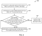
FIG. 5 illustrates a flow chart of operations performed by the data service of FIG. 2A for generating a bloom filter set, in accordance with an example embodiment;
FIG. 6 illustrates a flow chart of operations performed by the client of FIG. 2B for retrieving traffic data, in accordance with an example embodiment; and
FIG. 7 illustrates an exemplary map area for which traffic data may be retrieved by the client device of FIG. 2B, in accordance with one or more example embodiments.
DETAILED DESCRIPTION
In the following description, for purposes of explanation, numerous specific details are set forth in order to provide a thorough understanding of the present disclosure. It will be apparent, however, to one skilled in the art that the present disclosure may be practiced without these specific details. In other instances, apparatuses and methods are shown in block diagram form only in order to avoid obscuring the present disclosure.
Reference in this specification to “one embodiment” or “an embodiment” means that a particular feature, structure, or characteristic described in connection with the embodiment is included in at least one embodiment of the present disclosure. The appearance of the phrase “in one embodiment” in various places in the specification are not necessarily all referring to the same embodiment, nor are separate or alternative embodiments mutually exclusive of other embodiments. Further, the terms “a” and “an” herein do not denote a limitation of quantity, but rather denote the presence of at least one of the referenced items. Moreover, various features are described which may be exhibited by some embodiments and not by others. Similarly, various requirements are described which may be requirements for some embodiments but not for other embodiments.
Some embodiments of the present invention will now be described more fully hereinafter with reference to the accompanying drawings, in which some, but not all, embodiments of the invention are shown. Indeed, various embodiments of the invention may be embodied in many different forms and should not be construed as limited to the embodiments set forth herein; rather, these embodiments are provided so that this disclosure will satisfy applicable legal requirements. Like reference numerals refer to like elements throughout. As used herein, the terms “data,” “content,” “information,” and similar terms may be used interchangeably to refer to data capable of being transmitted, received and/or stored in accordance with embodiments of the present invention. Thus, use of any such terms should not be taken to limit the spirit and scope of embodiments of the present invention.
Additionally, as used herein, the term ‘circuitry’ may refer to (a) hardware-only circuit implementations (for example, implementations in analog circuitry and/or digital circuitry); (b) combinations of circuits and computer program product(s) comprising software and/or firmware instructions stored on one or more computer readable memories that work together to cause an apparatus to perform one or more functions described herein; and (c) circuits, such as, for example, a microprocessor(s) or a portion of a microprocessor(s), that require software or firmware for operation even if the software or firmware is not physically present. This definition of ‘circuitry’ applies to all uses of this term herein, including in any claims. As a further example, as used herein, the term ‘circuitry’ also includes an implementation comprising one or more processors and/or portion(s) thereof and accompanying software and/or firmware. As another example, the term ‘circuitry’ as used herein also includes, for example, a baseband integrated circuit or applications processor integrated circuit for a mobile phone or a similar integrated circuit in a server, a cellular network device, other network device, and/or other computing device.
As defined herein, a “computer-readable storage medium,” which refers to a non-transitory physical storage medium (for example, volatile or non-volatile memory device), may be differentiated from a “computer-readable transmission medium,” which refers to an electromagnetic signal.
The embodiments are described herein for illustrative purposes and are subject to many variations. It is understood that various omissions and substitutions of equivalents are contemplated as circumstances may suggest or render expedient but are intended to cover the application or implementation without departing from the spirit or the scope of the present disclosure. Further, it is to be understood that the phraseology and terminology employed herein are for the purpose of the description and should not be regarded as limiting. Any heading utilized within this description is for convenience only and has no legal or limiting effect.
Various embodiments of the present disclosure provide means through which, the traffic data of the map area may be determined using the data service version of the digital map and then decoded using the client version of the digital map. Therefore, the differences between the data service version and the client version of the digital map may be minimized. Additionally, the bandwidth used to provide the traffic data is minimized by encoding the road segments belonging to the one particular range of traffic data, using the smallest bit arrays that do not provide any false positives for road segments belonging to other ranges of traffic data. These and other technical improvements of the invention will become evident from the description provided herein.
FIG. 1 illustrates a block diagram 100 of an example architecture of one or more example embodiments. As shown in FIG. 1, the block diagram 100 may include a data service 101, an Original Equipment Manufacturer (OEM) cloud 103, a client 105, a mapping platform 107, and a network 109. In various embodiments, the data service 101 may be a backend server, a remotely located server, or the like. In an embodiment, the data service 101 may be the server 107 b of the mapping platform 107 and therefore may be co-located with or within the mapping platform 107. In various embodiments, the client 105 may be onboard a vehicle. In various embodiments, the client 105 may be a vehicle navigation system, vehicle control system, a mobile computing device and/or the like.
The mapping platform 107 may comprise a database 107 a for storing map data and a server 107 b. The database 107 a may store node data, road segment data, link data, link identification information, heading value records, point of interest (POI) data, or the like. The database 107 a may also store cartographic data, routing data, and/or maneuvering data. According to some example embodiments, the road segment data records may be links or segments representing roads, streets, or paths, as may be used in calculating a route or recorded route information for determination of one or more personalized routes. The node data may be end points corresponding to the respective links or segments of road segment data. The road link data and the node data may represent a road network, such as used by vehicles, cars, trucks, buses, motorcycles, and/or other entities. Optionally, the database 107 a may contain path segment and node data records, such as shape points or other data that may represent pedestrian paths, links or areas in addition to or instead of the vehicle road record data, for example. The road/link segments and nodes can be associated with attributes, such as geographic coordinates, street names, address ranges, speed limits, turn restrictions at intersections, and other navigation related attributes, as well as POIs, such as fueling stations, hotels, restaurants, museums, stadiums, offices, auto repair shops, buildings, stores, parks, etc. The database 107 a may also store data about the POIs and their respective locations in the POI records. The database 107 a may additionally store data about places, such as cities, towns, or other communities, and other geographic features such as bodies of water, mountain ranges, etc. Such place or feature data can be part of the POI data or can be associated with POIs or POI data records (such as a data point used for displaying or representing a position of a city). In addition, the database 107 a can include event data (e.g., traffic incidents, construction activities, scheduled events, unscheduled events, accidents, diversions etc.) associated with the POI data records or other records of the database 107 a. Optionally or additionally, the database 107 a may store 3D building maps data (3D map model of objects) of structures surrounding roads and streets.
The database 107 a may be maintained by a content provider e.g., a map developer. By way of example, the map developer may collect geographic data to generate and enhance the database 107 a. There may be different ways used by the map developer to collect data. These ways may include obtaining data from other sources, such as municipalities or respective geographic authorities. In addition, the map developer may employ field personnel to travel by vehicle along roads throughout the geographic region to observe features and/or record information about them, for example. Also, remote sensing, such as aerial or satellite photography, may be used to generate map geometries directly or through machine learning as described herein.
The database 107 a may be a master database stored in a format that facilitates updating, maintenance, and development. For example, the master database or data in the master database may be in an Oracle spatial format or other spatial format, such as for development or production purposes. The Oracle spatial format or development/production database may be compiled into a delivery format, such as a geographic data files (GDF) format. The data in the production and/or delivery formats may be compiled or further compiled to form geographic database products or databases, which may be used in end user navigation devices or systems.
For example, geographic data may be compiled (such as into a platform specification format (PSF) format) to organize and/or configure the data for performing navigation-related functions and/or services, such as route calculation, route guidance, map display, speed calculation, distance and travel time functions, and other functions, by a navigation device, such as by client such as the client 105, for example. The navigation-related functions may correspond to vehicle navigation, pedestrian navigation, or other types of navigation. The compilation to produce the end user databases may be performed by a party or entity separate from the map developer. For example, a customer of the map developer, such as a navigation device developer or other end user device developer, may perform compilation on a received database in a delivery format to produce one or more compiled navigation databases.
As mentioned above, the database 107 a may be a master geographic database, but in alternate embodiments, the database 107 a may be embodied as a client-side database and may represent a compiled navigation database that may be used in or with end user devices (e.g., the client 105) to provide navigation and/or map-related functions. For example, the database 107 a may be used with the client 105 to provide an end user with navigation features. In such a case, the database 107 a may be downloaded or stored on the client 105.
The server 107 b may comprise processing means and communication means. For example, the processing means may comprise one or more processors configured to process requests received from the client 105. The processing means may fetch map data from the database 107 a and transmit the same to the client 105 and/or the data service 101 in a format suitable for use by the client 105 and/or the data service 101. In one or more example embodiments, the mapping platform 107 may periodically communicate with the client 105 via the processing means to update a local cache of the map data stored on the client 105. Accordingly, in some example embodiments, the map data may also be stored on the client 105 and may be updated based on periodic communication with the mapping platform 107.
The mapping platform 107 may be communicatively coupled to the client 105, via the network 109. In an embodiment, the mapping platform 107 may communicate with the OEM cloud 103 via the network 109, which in turn may be connected to the client 105. The client 105 may be any user accessible device such as a mobile phone, a smartphone, a portable computer, and the like that is portable in itself or as a part of another portable/mobile object such as a vehicle. In some example embodiments, the client 105 may be associated, coupled, or otherwise integrated with a vehicle of the user, such as an advanced driver assistance system (ADAS), a personal navigation device (PND), a portable navigation device, an infotainment system and/or other device that may be configured to provide route guidance and navigation related functions to the user. In this context, the user may be an autonomous or semi-autonomous vehicle. The client may comprise processing means such as a central processing unit (CPU), storage means such as onboard read only memory (ROM) and random access memory (RAM), acoustic sensors such as a microphone array, position sensors such as a GPS sensor, orientation sensors such as gyroscope, motion sensors such as accelerometer, a display enabled user interface such as a touch screen display, and other components as may be required for specific functionalities of the client 105. Additional, different, or fewer components may be provided. For example, the client 105 may be configured to execute and run mobile applications such as a messaging application, a browser application, a navigation application, and the like.
The network 109 may be wired, wireless, or any combination of wired and wireless communication networks, such as cellular, Wi-Fi, internet, local area networks, or the like. In one embodiment, the network 109 may include one or more networks such as a data network, a wireless network, a telephony network, or any combination thereof. It is contemplated that the data network may be any local area network (LAN), metropolitan area network (MAN), wide area network (WAN), a public data network (e.g., the Internet), short range wireless network, or any other suitable packet-switched network, such as a commercially owned, proprietary packet-switched network, e.g., a proprietary cable or fiber-optic network, and the like, or any combination thereof. In addition, the wireless network may be, for example, a cellular network and may employ various technologies including enhanced data rates for global evolution (EDGE), general packet radio service (GPRS), global system for mobile communications (GSM), Internet protocol multimedia subsystem (IMS), universal mobile telecommunications system (UMTS), etc., as well as any other suitable wireless medium, e.g., worldwide interoperability for microwave access (WiMAX), Long Term Evolution (LTE) networks (for e.g. LTE-Advanced Pro), 5G New Radio networks, ITU-IMT 2020 networks, code division multiple access (CDMA), wideband code division multiple access (WCDMA), wireless fidelity (Wi-Fi), wireless LAN (WLAN), Bluetooth, Internet Protocol (IP) data casting, satellite, mobile ad-hoc network (MANET), and the like, or any combination thereof.
FIG. 2A illustrates a block diagram of the data service 101 for providing traffic data, in accordance with one or more example embodiments. The data service 101 may include a processing means such as at least one processor 201 a, storage means such as at least one memory 203 a, and a communication means such as at least one communication interface 205 a. The processor 201 a may retrieve computer program code that may be stored in the memory 203 a for execution of the computer program code. In some embodiments, the data service 101 may be implemented as part of the mapping platform 107.
FIG. 2B illustrates a block diagram of the client 105 for requesting traffic data, in accordance with one or more example embodiments. The client 105 may include a processing means such as at least one processor 201 b, storage means such as at least one memory 203 b, and a communication means such as at least one communication interface 205 b. The processor 201 b may retrieve computer program code instructions that may be stored in the memory 203 b for execution of the computer program code instructions.
The processors 201 a and 201 b may be embodied in a number of different ways. For example, the processors 201 a and 201 b may be embodied as various hardware processing means such as coprocessors, microprocessors, controllers, digital signal processors (DSPs), processing elements with or without accompanying DSPs, or various other processing circuitries including integrated circuits such as, for example, ASICs (application specific integrated circuit), FPGAs (field programmable gate array), microcontroller units (MCU), hardware accelerators, special-purpose computer chips, or the like. As such, in some embodiments, the processors 201 a and 201 b may include processing cores configured to perform independently. A multi-core processor may enable multiprocessing within a single physical package. Additionally or alternatively, the processors 201 a and 201 b may include one or more processors configured in tandem via the bus to enable independent execution of instructions, pipelining and/or multithreading.
Additionally or alternatively, the processors 201 a and 201 b may include processors capable of processing large volumes of workloads and operations to provide support for big data analysis. In an example embodiment, the processors 201 a and 201 b may be in communication with memories 203 a and 203 b respectively via buses for passing information among components of structure 100. The memories 203 a and 203 b may be non-transitory and may include, for example, one or more volatile and/or non-volatile memories. In other words, for example, the memories 203 a and 203 b may be electronic storage devices (for example, a computer readable storage medium) comprising gates configured to store data (for example, bits) that may be retrievable by a machine (for example, a computing device like the processors (201 a and/or 201 b). The memories 203 a and 203 b may be configured to store information, data, content, applications, instructions, or the like, for enabling the apparatus to carry out various functions in accordance with an example embodiment of the present invention. For example, the memories 203 a and 203 b may be configured to buffer input data for processing by the processors 201 a and 201 b respectively. As exemplarily illustrated in FIG. 2A and FIG. 2B, the memories 203 a and 203 b may be configured to store instructions for execution by the processors 201 a and 201 b respectively. As such, whether configured by hardware or software methods, or by a combination thereof, the processors 201 a and 201 b may represent entities (for example, physically embodied in circuitry) capable of performing operations according to an embodiment of the present invention while configured accordingly. Thus, for example, when the processors 203 and 303 are embodied as ASICs, FPGAs or the like, the processors 201 a and 201 b may be specifically configured hardware for conducting the operations described herein. Alternatively, as another example, when the processors 201 a and 210 b are embodied as an executor of software instructions, the instructions may specifically configure the processors 201 a and 201 b to perform the algorithms and/or operations described herein when the instructions are executed. However, in some cases, the processors 201 a and 201 b may be processor specific devices (for example, mobile terminal or fixed computing devices) configured to employ an embodiment of the present invention by further configuration of the processors 201 a and 201 b by instructions for performing the algorithms and/or operations described herein. The processors 201 a and 201 b may include, among other things, clocks, arithmetic logic units (ALU) and logic gates configured to support operation of the processors 201 a and 201 b.
In some embodiments, the processors 201 a and 201 b may be configured to provide Internet-of-Things (IoT) related capabilities to users of the data service 101 and the client 105 respectively, where the users may be a traveler, a rider, a pedestrian, and the like. In some embodiments, the users may be or correspond to an autonomous or semi-autonomous vehicle. The IoT related capabilities may in turn be used to provide smart navigation solutions by providing real time updates to the users to take pro-active decision on turn-maneuvers, lane changes, overtaking, merging and the like, big data analysis, and sensor-based data collection by using the cloud based mapping system for providing navigation recommendation services to the users. The data service 101 and the client 105 may be accessed using the communication interfaces 205 a and 205 b respectively. The communication interfaces 205 a and 205 b may provide interfaces for accessing various features and data stored in the data service 101 and the client 105.
FIG. 3 illustrates a flow chart 300 representing general overview of steps performed by the client 105 and the data service 101 for executing the traffic data protocol, in accordance with an example embodiment. Blocks 301, 303, 305, 319, 321, and 323 of the flow chart 300 may be performed by the client 105 for retrieving the traffic data. Blocks 307, 309, 311, 313, 315, and 317 of the flow chart 300 may be performed by the data service 101 for providing the traffic data updates.
At block 301, the method comprises determining at least one map area comprising road segments. The map area may be referred to by a map area identifier or map tile identifier. At block 303, the method comprises determining road segment identifiers for the road segments of the at least one map area. In various embodiments, the coded map version agnostic identifiers may be the road segment identifiers.
At block 305, the method comprises sending a request for the traffic data from the client to the data service. The request may identify the map area. The client may then wait for the data service to provide the requested traffic data. The operations performed by the data service starts at block 307, where the method comprises receiving the request for the traffic data from the client.
At block 309, the method comprises determining road segment identifiers corresponding to each of the road segments of the at least one map area at the data service side. At block 311, the method comprises determining traffic data for at least a portion of the road segment identifiers at the data service side. The traffic data is obtained from a traffic data source. For example, the traffic data source may be the mapping platform 107 or the memory 203 a of the data service.
At block 313, the method comprises determining a plurality of traffic ranges based on the obtained traffic data. At block 315, the method may comprise generating a bloom filter set, each bloom filter of the bloom filter set corresponding to a traffic range of the plurality of traffic ranges. Each bloom filter encodes road segment identifiers corresponding to the respective traffic range.
At block 317, the method comprises providing the bloom filter set to the client from the data service. For example, the data service may transmit the requested traffic data as the bloom filter set, to the client. The client resumes operations at block 319, where the method comprises receiving the bloom filter set from the data service. The bloom filter set may comprise a plurality of bloom filters. The bloom filters in the set may correspond to traffic ranges.
At block 321, the method comprises associating a road segment in a corresponding traffic range based on the road segment identifier satisfying one bloom filter of the traffic range. At block 323, the method may additionally or optionally comprise providing the traffic range as traffic data for the road segment to a navigation application. The navigation application may be a map display, a routing engine and the like.
FIG. 4 illustrates a flow chart 400 of operations performed by the data service 101 of FIG. 2A for providing traffic data, in accordance with an example embodiment. Starting at block 401, the data service 101 may be configured to receive a request for traffic data corresponding to road segments of at least one map area (e.g., map area ID or map tile ID) from the client 105. The data service 101 may determine the at least one map area in the data service version of digital map stored in the memory 203 a. In various embodiments, the at least one map area is independent of a version of the digital map. In various embodiments, the request may further comprise a traffic resolution parameter, at least one functional class, and/or validity time frame for the map tile ID.
At block 403, the data service 101 may be configured to determine the road segment identifiers corresponding to each of the road segment of the at least one map area. The data service 101 may access map version agnostic information for each of the road segments of the at least one map area. For example, the data service 101 may store (e.g., in the memory 203 a) a geographic database storing the data service version of the digital map. A segment record corresponding to the each of road segments may be accessed and map version agnostic information may be extracted therefrom. In an example embodiment, elements of each of the road segment record to be accessed are pre-established and/or defined. In various embodiments, the map version agnostic map information/data accessed may include a road name, segment length, a direction of travel of a segment, a functional class of a segment, speed limit, segment midpoint, and/or the like.
The data service 101 may determine the map version agnostic identifiers corresponding to each of the road segments of the at least one map area using the map version agnostic information. For example, one or more map version agnostic elements of the map information corresponding to each of the road segment may be used to generate the map version agnostic identifier of the road segment. In an example embodiment, the one or more map version agnostic elements of the map information and an order in which map version agnostic elements are combined to generate the map version agnostic identifier is pre-established and/or defined. The data service 101 and the client 105 are both configured to generate map version agnostic identifiers in the same pre-established and/or defined way (e.g., using the same elements of map information combined in the same order). For example, the map version agnostic identifier may be generated using a map version agnostic identifier algorithm. The data service 101 and the client 105 may use the same map version agnostic identifier algorithm. In an example embodiment, the map version agnostic identifier may be a text string generated by concatenating the functional class and the travel direction to the road name. Further, the data service 101 may code each of the map version agnostic identifier using one or more coding functions. In an embodiment, the one or more coding functions include one or more hashing functions. For example, the one or more coding functions may include a deterministic hashing function such as a secure hash algorithm (SHA), MD5 message-digest algorithm, and/or the like. The data service 101 may deliver the coded map version agnostic identifiers as the road segment identifiers.
At block 405, the data service 101 may be configured to determine the traffic data for at least a portion of the road segment identifiers. In an embodiment, the data service 101 may obtain the traffic data from the memory 203 a (i.e., data service version of the digital map). In various embodiments, the traffic data may be speed predictions of the road segments of the at least one map area. In an embodiment, the speed predictions may be predictions made from historical, real-time traffic data, or a combination of both. In an embodiment, the data service 101 may determine traffic data of each of first road segments among the road segments of the at least one map area. For example, the road segments may or may not contain traffic data (or speed data in some example embodiments). Road segments which contain the traffic data are termed as the first road segments. Road segments which do not contain the traffic data are termed as second road segments. According to some embodiments, the data service 101 may determine the traffic data for at least a portion of the road segment identifiers (e.g., for first road segments) in the validity time frame present in the request. According to some other embodiments, the data service 101 may extract the at least one functional class of the at least one map area from the request. The data service 101 may determine traffic data only for road segments that are associated with the at least one functional class (FC) parameter. For example, functional classes of the road segments may indicate types of road segments in the map. In various embodiments, the road segment types may be highways, freeways, regional roads, alleys and/or the like. In an embodiment, the functional class parameter may be a numbered value. For example, if the functional class (FC) is one (i.e., FC=1), the data service 201 may determine traffic data of highways in the at least one map area.
At block 407, the data service 101 may be configured to determine the plurality of traffic ranges based on the obtained traffic data. In some example embodiments, a traffic range may mean to be one particular range of traffic speed. The data service 101 may determine the plurality of road segment identifier sets for the road segment identifiers. Each road segments identifier (e.g., road segment identifiers of the first road segments) belonging to respective one of the plurality of ranges may be added to a respective road segment identifier set. For example, if a road segment identifier set has a traffic speed range of 21-30 km/h, then all the road segment identifiers falling within or on the range of 21-30 km/h are members of the road segment identifier set with the range 21-30 km/h. The number of road segment identifier sets to be determined is based on a maximum traffic speed of the first road segments and the traffic resolution parameter. For example, if the maximum traffic speed of the first road segments is 120 km/h and the traffic resolution value is 30, then four road segment identifier sets (i.e., maximum traffic speed÷traffic resolution parameter) may be determined of ranges 1-30 km/h, 31-60 km/h, 61-90 km/h, and 91-120 km/h. In an embodiment, the data service 101 may extract the traffic resolution parameter from the request. In alternate embodiment, the data service 101 may determine the traffic resolution parameter using the at least one functional class (FC) parameter present in the request. For example, if FC=1, which may mean highways of the map area, the traffic resolution parameter for FC=1 is a default value stored in the data service 101. In alternate embodiments, the ranges may be expressed using a pre-determined quality scale, such as “Free-Flow”, “Light Traffic”, “Moderate Traffic”, “Heavy Traffic”, and/or “Blocked”.
At block 409, the data service 101 may be configured to generate the bloom filter set, each bloom filter of the bloom filter set corresponding to a traffic range of the plurality of traffic ranges. For example, the data service 101 may generate a plurality of bloom filters for the plurality of road segment identifier sets. Each bloom filter of the plurality of bloom filters may correspond to a respective one of the plurality of road segment identifier sets. In various embodiments, each bloom filter of the plurality of bloom filters may encode all road segment identifiers of the respective one of the plurality of road segment identifier sets. The data service 101 may generate a plurality of identifier test sets for the plurality of bloom filters/the plurality of road segment identifier sets. Each identifier test set of the plurality of identifier test set may correspond to a respective one of the plurality of bloom filters. For example, all road segment identifiers of each identifier test set may be tested with the respective one of the plurality of bloom filters to determine a match for the respective bloom filter. For example, if any road segment identifier of a sample identifier test set (T_0) satisfies a sample bloom filter (B_0) (e.g., of size ‘m’), then a match is determined for the sample bloom filter and the data service 101 may reject the sample bloom filter. The data service 101 may then generate a larger sized bloom filter (e.g., of size ‘m+1’). The data service 101 may again code the larger sized bloom filter with all road segment identifiers of a sample road segment identifier set corresponding to the sample bloom filter. According to some example embodiments, the testing process may be stopped, when no match is determined for the larger sized bloom filter. In this way, the processing may be executed for other bloom filters of the plurality of bloom filters and the data service 101 may generate an ordered list of bloom filter set, where the bloom filter set contains a plurality of bloom filters that have passed the aforementioned testing process.
At block 411, the data service 101 may be configured to transmit/provide the encoded traffic data comprising the bloom filter set of the at least one map area, to the client 105. The encoded traffic data may further comprise a total count of encoded road segments, time information of the traffic data of the first road segments and the like. In an embodiment, the data service 101 may compute the total count of encoded road segments. For example, a number of the first road segments of the at least one map area may be the total count of encoded road segments. In an embodiment, the time information (such as validity time frame) of the traffic data may be obtained from the database.
FIG. 5 illustrates a flow chart 500 of operations performed by the data service 101 of FIG. 2A for generating the bloom filter set, in accordance with an example embodiment. Starting at block 501, the data service 101 may be configured to generate the bloom filter for each of the plurality of traffic ranges. For example, the data service 101 may initialize the bloom filter for each of the plurality of traffic ranges with a size that is relatively small, such that the probability of false positive is arbitrarily high. The plurality of traffic ranges (i.e., road segment identifier sets) may comprise the road segment identifiers of the first road segments. The data service 101 may add all road segment identifiers of the respective one of the plurality of traffic ranges to a respective initialized bloom filter. For example, consider a sample bloom filter which may correspond to the sample road segment identifier set. All the road segment identifiers (i.e., coded map version agnostic identifiers) in the sample road segment identifier set are added to the sample bloom filter. Since the sample road segment identifier set corresponds to a sample range of traffic data, the sample bloom filter may encode all sample road segments belonging to the sample range of traffic data.
At block 503, the data service 101 may be configured to determine the identifier test set for each of the bloom filters. The identifier test set may comprise the road segment identifiers of the second road segments and one or more road segment identifiers among the road segment identifiers of the first road segments. For example, the sample identifier test set determined for the sample bloom filter may contain the road segment identifiers of the second road segments and all the road segment identifiers of the first road segments except the road segment identifiers in the sample road segment identifier set. For example, in short, the sample identifier test set determined for the sample bloom filter may be a complement set for the sample road segment identifier set. For example, consider three bloom filters BF_0, BF_1, and BF_2 which may correspond to three road segment identifier sets S_0, S_1, and S_2 respectively. An identifier test set T_0 may be determined (e.g., by the data service 101) for the bloom filter BF_0, such that members of the identifier test set T_0 are the road segment identifiers of the second road segments and road segment identifiers of the road segment identifier sets S_1 and S_2 (i.e., a complement set for the set S_0). Similarly, the identifier test sets T_1 and T_2 may be the complement set for the set S_1 and the set S_2 respectively.
At block 505, the data service 101 may be configured to determine whether any road segment identifier of the respective one of the identifier test sets satisfies the respective bloom filter. For example, the sample identifier test set determined at block 503 may be used to test the sample bloom filter to determine whether any road segment identifier of the sample identifier test set satisfies the sample bloom filter.
When it is determined that none of the element (road segment identifier) of the respective one of the identifier test sets satisfy the respective bloom filter, the process 500 (i.e., flow chart) may continue with block 507. At block 507, the data service 101 may be configured to output the respective bloom filter to generate the bloom filter set. For example, a bloom filter module operating on and/or being executed by the data service 101 may output the respective bloom filter, at block 507, to a traffic data generation module operating on and/or being executed by the data service 101.
When it is determined that at least one element (road segment identifier) of the respective one of the identifier test sets satisfies the respective bloom filter, the process 500 may continue with block 509. At block 509, the data service 101 may be configured to generate the new bloom filter replacing the respective bloom filter. In various embodiments, the data service 101 may reject the respective bloom filter. For example, if the respective bloom filter, at block 505, is of size m (e.g., be a bit array of m bits), the data service 101 may initialize the new bloom filter of size m+n (e.g., a bit array of m+n bits). As used herein, n is a positive integer. In an example embodiment, n is 1, such that the minimum sized bloom filter that does not provide a false positive for any road segment identifier of a respective identifier test set corresponding to the respective bloom filter. The data service 101 may be configured to encode (add) the newly initialized bloom filter with all road segment identifiers of a respective road segment identifier set that correspond to the respective bloom filter.
As should be understood, once the new bloom filter is generated, the process 500 may return to block 505, the data service 101 may be configured to determine whether any element of the respective identifier test set satisfies the new bloom filter. For example, the data service 101 may determine whether any of the road segment identifier of the respective identifier test set is a member of the respective road segment identifier set. Responsive to determining that the new bloom filter does not indicate that any of the road segment identifier of the respective identifier test set as a member of the respective road segment identifier set, the data service 101 may continue with block 507. Responsive to determining that the new bloom filter does indicate that at least one of the road segment identifier of the respective identifier test set as a member of the respective road segment identifier set, the data service may continue with block 509 and a new larger bloom filter is generated for replacing the new bloom filter. For example, a new larger bloom filter of size (m+n)+n, where n is a positive integer, may be generated for replacing the new bloom filter. In an example embodiment, n is 1. The process continues until the bloom filter for each of the road segment identifier sets indicates that none of the road segment identifiers of a respective one of the identifier test sets is a member of the respective road segment identifier set. The bloom filter for each of the road segment identifier sets is outputted at block 507.
FIG. 6 illustrates a flow chart 600 of operations performed by the client 105 of FIG. 2B for requesting the traffic data, in accordance with an example embodiment. Starting at block 601, the client 105 may be configured to determine at least one map area comprising road segments. According to some example embodiments, the client version of the digital map (i.e., map) may be partitioned in two-dimensions (for example in a gridded, tiled, and/or tessellated form). In various embodiments, the number of cells of the grid may determine a level (e.g., first level of partition, second level of partition and so on) of the client version of the digital map. For example, the client version digital map may be divided into 4 geographical regions in level-1 (e.g., first level of partition), 16 geographical regions in level-2 (e.g., second level of partition), and so on. As used herein, the geographical region is the map area or the map tile. Accordingly, the map area may cover an area of the client version of the digital map. Each of the map area (i.e., a cell of the grid) may be referred by identifiers (i.e., map area identifiers/map tile identifiers). In an alternate embodiment, the map area may indicate a current area visible on the screen of the navigation application and the like (i.e., client 105). According to some example embodiments, the map area comprises road segments. Alternate embodiments may cover a geographical partition in three dimensions (for example in a cubed form).
In an embodiment, the client 105 (e.g., the navigation application) may be triggered when a user or an application associated with the client 105 provides a start point and a destination point. The client 105 may determine a potential route between the start point and the end point. For example, the client 105 may use Dijkstra's algorithm, shortest path algorithm, minimum spanning tree algorithm and the like for determining the potential route. In various embodiments, the potential route may be a fastest route to reach the destination point, a short distance route between the start point and the destination point, and the like. The client 105 may determine a geographic region encompassing the potential route. For example, the client 105 may choose a level (e.g., any arbitrary partition of client version of the digital map) to determine the geographic region encompassing the potential route, such that the level contains sufficient amount of traffic information/data of the potential route. Accordingly, the client 105 may determine at least one map area ID that covers the geographic region encompassing the potential route. For example, the client 105 may use the potential route and the level of the client version of the digital map to determine the at least one map area ID that covers the geographic region encompassing the potential route.
At block 603, the client 105 may be configured to determine the road segment identifier for each of the road segments in the at least one map area. In various embodiments, the client 105 may generate map version agnostic identifiers to determine the road segment identifiers. For example, the client 105 may obtain the map version agnostic information of the map area ID to generate the map version agnostic identifier for each of the road segments of the map area ID. For example, the client 105 may store geographic database storing the map version agnostic information of the client version of the digital map. A segment record corresponding to a road segment may be obtained and map version agnostic information may be extracted therefrom. In an example embodiment, elements of the segment record to be obtained are pre-established and/or defined. For example, the map version agnostic information obtained may include a name of the road segment, a length of the road segment, a travel direction of the road segment, a functional class of the road segment, speed limit of the road segment, midpoint of the road segment, and/or the like.
The map version agnostic identifiers may be generated using the map version agnostic information. For example, one or more map version agnostic elements of the map information corresponding to a road segment may be used to generate a map version agnostic identifier for the road segment. In an example embodiment, the one or more map version agnostic elements of the map information and an order in which map version agnostic elements are combined to generate the map version agnostic identifier is pre-established and/or defined. The data service 101 and the client 105 are both configured to generate map version agnostic identifiers in the same pre-established and/or defined way (e.g., using the same elements of map information combined in the same order). For example, the map version agnostic identifier may be generated using a map version agnostic identifier algorithm and the data service 101 and the client 105 may use the same map version agnostic identifier algorithm. In an example embodiment, the map version agnostic identifier may be a text string generated by concatenating the functional class and the travel direction to the road name. Further, the client 105 may code each of the map version agnostic identifier using one or more coding functions. In an example embodiment, the one or more coding functions may include one or more hashing functions. For example, the one or more coding functions may include a deterministic hashing function such as a secure hash algorithm (SHA), MD5 message-digest algorithm, and/or the like. The coded map version agnostic identifiers are represented as the road segment identifiers.
At block 605, the client 105 may be configured to transmit the request indicating the at least one map area. According to some example embodiments, if the request comprises more than one map area ID, the client 105 may request the traffic data in form of a bounding box, map area range and/or the like. In various embodiments, the bounding box/map area range is a set comprising one or more map area IDs. In various embodiments, the request for the traffic data may further comprise at least one functional class parameter of road segments of the at least one map area, a validity time frame of the at least one map area (e.g., a time frame for which traffic data need to be updated). According to some example embodiments, the client 105 may determine a validity time frame (entry time and exit time) of the map area while determining the potential route (using spanning tree algorithm and the like).
Furthermore, the client 105 may be configured to determine a traffic resolution value/parameter for the at least one map area. The traffic resolution value of the at least one map area may be used to determine a number of ranges (traffic ranges) the traffic data of the at least one map area to be grouped. According to some example embodiments, the traffic resolution value may be determined by using a maximum traffic speed limit of the map area. For example, the client 105 may contain posted speed limits of the road segments of the map area as an attribute. The client 105 may use the attribute to determine the maximum traffic speed limit of the map area. Further, the client 105 may use the maximum traffic speed limit of the map area to determine the traffic resolution value. For example, if the maximum traffic speed data of the road segments of the map area is 120 km/h then four traffic speed groups of ranges 1-30 km/h, 31-60 km/h, 61-90 km/h, and 91-120 km/h are sufficient to group the road segments of the map area. If the maximum traffic speed data of the road segments of the map area is 50 km/h, then the traffic speed groups of ranges 1-30 km/h and 31-60 km/h may not be sufficient to group the road segments (as in case of maximum traffic speed=120 km/h). Accordingly, traffic speed groups of ranges 1-10 km/h, 11-20 km/h, 21-30 km/h, 31-40 km/h, and 41-50 km/h are required to group the road segments of the map area to provide reliable speed information. Further, the client 105 may be configured to transmit the traffic resolution value as part of the request to the data service 101.
At block 607, the client 105 may be configured to receive, from the data service 101, the encoded traffic data comprising at least one bloom filter set for the at least one requested map area. The bloom filter set may comprise an order list of a plurality of bloom filters, where each bloom filter in the bloom filter set corresponds to one particular traffic speed range. According to some example embodiments, a bloom filter appearing first in the ordered list of bloom filter set may correspond to lower traffic speed range and vice versa. According to some embodiments, each bloom filter of the bloom filter set may encode one or more road segment identifiers of the road segments of the map area belonging to one particular range of traffic speed data. In various embodiments, each bloom filter in the bloom filter set may be mutually exclusive to each other. For example, consider a bloom filter set which may contain three bloom filters BF_0, BF_1, and BF_2 (from above example). The road segment identifiers encoded in the bloom filter BF_0 may not be present in bloom filters BF_1 and BF_2. Similarly, the road segment identifiers in the bloom filter BF_1 may not be present in bloom filters BF_0 and BF_2 and the road segment identifiers in the bloom filter BF_2 may not be present in the bloom filters BF_1 and BF_0. The encoded traffic data may further comprise a total count of encoded road segments and/or time information of the traffic data of the at least one map area. The time information of the traffic data may be used to validate the traffic data. For example, the time information may indicate a period of time for which the traffic data may be valid. According to some example embodiments, the total count of encoded road segments may be used to determine a trigger whether to update or not to update the traffic data on the client device.
At block 609, the client 105 may be configured to check for the match of each of the road segment identifier in the bloom filter set. For example, the client 105 may check whether a road segment identifier satisfies any bloom filter of the bloom filter set. In various embodiments, the road segment identifiers are the coded map version agnostic identifiers. Accordingly, each coded map version agnostic identifier may be checked with each bloom filter of the bloom filter set to determine whether there is a match. According to various embodiments, the road segment identifiers with match are termed as the first road segment identifiers and the road segment identifiers without match as are termed as second road segment identifiers.
The client 105 may be configured to generate the traffic data for each of the first road segment identifiers. In various embodiments, the client 105 may assign a traffic range (e.g. speed range) for each of the first road segment identifiers. As described above, each bloom filter of the bloom filter set may correspond to one particular traffic speed range. The client 105 may assign the range of a bloom filter to a first road segment identifier, if the first road segment identifier satisfies the bloom filter. According to various embodiments, the client 105 may determine an index value of the bloom filter in the bloom filter set to compute a speed value for each of the first road segment identifiers. For example, the client 105 may use the index value of the bloom filter and the traffic resolution value to compute the speed value of a first road segment identifier. For example, the client 105 may assign the speed value for the first road segment identifier as ((index value of the bloom filter+0.5)*traffic resolution value).
Additionally, the client 105 may be configured to determine a total count of decoded road segments for the map area. In various embodiments, a total number of first road segment identifiers may be the total count of decoded road segments. In an alternate embodiment, the client 105 may initialize a variable with initial value set to zero. The client may add a value (e.g., value=1) to the variable, for each match of the road segment identifiers in the bloom filter set. Once, all the road segment identifiers are checked with each bloom filter of the bloom filter set, the variable may be the total count of decoded road segments. The client 105 may determine a trigger whether to update or not to update the traffic data using the total count of decoded road segments and the total count of encoded road segments. For example, the client 105 may determine a ratio of the total count of decoded road segments and the total count of encoded road segments. If the ratio is above a threshold value (e.g., threshold value=0.5), the client 105 may update the traffic data. If the ratio is below the threshold value, the traffic data may not be updated.
According to some embodiments, the client 105 may assign the traffic data for each of the second road segment identifiers, based on local data. However, the client 105 may also assign the traffic data for each of the first road segment identifiers, if the ratio is below the threshold value. In an embodiment, the client 105 may store the local data. In alternate embodiment, the client 105 may obtain the local data from a local database. In various embodiments, the local data may comprise posted speed limit data, traversal cost data, historic traffic speed pattern data, and/or the like. For example, the client 105 may obtain local data for the second road segment identifiers to generate the traffic data for each the second road segment identifiers. For example, the traffic data for the second road segment identifiers may be derived from the posted speed limit data, the traversal cost data, and/or the historical traffic speed pattern of the second road segment identifiers.
At 611, the client 105 may provide the traffic data, to the navigation application, for the road segments (e.g., for first road segment identifiers and second road segment identifiers) of the map tile ID. In some exemplary embodiment the navigation application may be but not limited to a map display, a routing engine and the like.
Accordingly, blocks of the flowcharts 300 to 600 support combinations of means for performing the specified functions and combinations of operations for performing the specified functions for performing the specified functions. It will also be understood that one or more blocks of the flowchart 300, 400, 500, 600 and combinations of blocks in the flowchart 300, 400, 500, 600 can be implemented by special purpose hardware-based computer systems which perform the specified functions, or combinations of special purpose hardware and computer instructions.
Alternatively, the system may comprise means for performing each of the operations described above. In this regard, according to an example embodiment, examples of means for performing operations may comprise, for example, the processor 201 a and/or 201 b, the memory 203 a and/or 203 b and/or a device or circuit for executing instructions or executing an algorithm for processing information as described above.
FIG. 7 illustrates a map area 700 for which traffic data may be updated by the client 105, in accordance with one or more example embodiments. In an embodiment, as described with reference to FIG. 6, the client 105 determines the map area ID 700 that covers the geographic region encompassing the potential route. In an alternate embodiment, the map area 700 may indicate a current area visible on the screen of the client 105. The map area comprises one or more road segments. For example, numerals 703, 705, 707, 709, 711, 713, 715, 717, 719, and 721 may indicate road segments in the map area 700. In the map area 700, a direction of travel of a vehicle, a pedestrian, a rider, or the like may be indicated by a numeral 701. The road segments within the map area 700 may be classified based on whether they have their corresponding traffic data. For example, the road segments 703, 705, 709, 711, 713, 715, and 721 may have the traffic data (e.g., speed data) and may therefore be grouped together (hereinafter referred as first road segments). Similarly, the road segments 707, 717, and 719 may not have the traffic data and may therefore be grouped in a different group (hereinafter referred as second road segments).
According to some example embodiments, the client 105 may generate the request the data service 101 to provide traffic data for the map area 700. For example, the request may include an identifier of the map area 700. According to some embodiments, the server 107 b of the mapping platform 107 may be the data service 101. Accordingly, the server 107 b of the mapping platform 107 may perform the operations performed by the data service 101.
The client 105 may transmit the request, to the server 107 b, to update the traffic data for the map area 700. The server 107 b may receive the request. The server 107 b may obtain the traffic data of the map area 700 from the database 107 a and determine the traffic data for the first road segments 703, 705, 709, 711, 713, 715, and 721 as 10 km/h, 15 km/h, 35 km/h, 48 km/h, 60 km/h, 32 km/h, and 58 km/h respectively.
The server 107 b may determine the maximum traffic data associated with the first road segments (Example: 60 km/h). The server 107 b may compute the number of traffic groups using the maximum traffic data and the resolution parameter. For example, the number of traffic groups may be equal to the ratio of the highest traffic data (i.e. 60 km/h) and the resolution parameter. For Example if, the resolution parameter is 20, then there may be three traffic ranges. The server 107 b may generate three road segment identifiers sets (S_0, S_1, and S_2) for the ranges 1-20 km/h, 21-40 km/h, and 41-60 km/h.
The server 107 b may generate the road segment identifiers of the road segments 703, 705, 707, 709, 711, 713, 715, 717, 719, and 721. The server 107 b may add the road segment identifiers of the first road segments to the three road segment identifiers sets. For example, the road segment identifiers of road segment 703 and 705 may be added to the first road segment identifiers set of range (1-20), since the road segments 703 and 705 fall within the range (1-20). Similarly, the road segment identifiers of road segments 709 and 715 may be added to the second road segment identifiers set of range (21-40), and the road segment identifiers of road segments 711, 713, and 721 may be added to the third road segment identifiers set of range (41-60).
The server 107 b may generate a bloom filter for each of the three road segment identifiers sets. For example, bloom filters BF_0, BF_1, and BF_2 may be initialized for the first road segment identifiers set (S_0), the second road segment identifiers set (S_1), and the third road segment identifiers set (S_2), respectively. The server 107 b may add all coded map version agnostic identifiers (e.g., the road segment identifier of 703 and 705) of the first road segment identifiers set (S_0) to the bloom filter BF_0. Similarly, the road segment identifiers 709 and 715 of the second road segment identifiers set (S_1) are added to the bloom filters BF_1. Further, the road segment identifiers 711, 713, and 721 of the third road segment identifiers set (S_2) are added to the bloom filter BF_2.
The server 107 b may generate an identifier test set for each of the bloom filters. For example, three identifier test sets T_0, T_1, and T_2 may be generated for the three bloom filters BF_0, BF_1, and BF_2 respectively. Identifier test set T_0 may be the complement set for the first road segment identifier set (S_0). For example, the identifier test set T_0 contains the road segment identifiers of the road segments 707, 709, 711, 713, 715, 717, 719, and 721. Similarly, the identifier test set T_1 contains the road segment identifiers of the road segments 703, 705, 707, 711, 713, 717, 719, and 721. Further, the identifier test set T_2 contains the road segment identifiers of the road segments 703, 705, 707, 709, 717, 719, and 715).
The server 107 b may determine whether, the bloom filter BF_0 is satisfied by any of the element of the identifier test set T_0 (e.g., 707, 709, 711, 713, 715, 717, 719, and 721). Similarly, the bloom filter BF_1 and BF_2 may be checked with all road segment identifiers of the identifier test set T_1 (e.g., 703, 705, 707, 711, 713, 717, 719, and 721) and T_2 (e.g., 703, 705, 707, 709, 717, 719, and 715) respectively.
If, any one of the road segment identifier of the identifier test set (T_0) matches with the bloom filter (BF_0), then the bloom filter (BF_0) is rejected and new bloom filter of larger size (e.g., m+1, if BF_0 of size “m” bits) is generated, which encodes the road segment identifiers of 703 and 705. Again the new bloom filter is tested with the identifier test set (T_0) to determine whether any road segment identifier of the set (T_0) satisfies the new bloom filter. The test is performed until none of the road segment identifier of set (T_0) matches with the bloom filter (BF_0). Similarly, the bloom filters BF_1 and BF_2 may be tested with the identifier test sets T_1 and T_2 respectively to generate false-positive-free bloom filters (the bloom filter that does not provide any false positive). The bloom filter set includes such false-positive-free bloom filters. The server 107 b may transmit the bloom filter set as the encoded traffic data of the map area 700 to the client 105.
The client 105 may receive the bloom filter set for the map area 700. The client 105 may generate the road segment identifiers of the road segments 703, 705, 707, 709, 711, 713, 715, 717, 719, and 721. The client 105 may check for a match (e.g., does a road segment identifier satisfy any bloom filter in the bloom filter set), for each of the road segment identifiers (e.g., 703, 705, 707, 709, 711, 713, 715, 717, 719, and 721) with each of the bloom filter (e.g., BF_0, BF_1, BF_2).
Accordingly, the match for the road segments 703 and 705 may be obtained in the bloom filter BF_0. In an embodiment, the client 105 may assign the traffic data as the traffic range associated with the matched bloom filter. In an alternate embodiment, the client 105 may assign the traffic data to the road segments as (bloom filter index+0.5)*traffic resolution value. For example, the bloom filter index of the first bloom filter is 0 (zero) in the bloom filter set, the traffic data of the road segment 703 may be determined as (0+0.5)*20=10 km/h. Similarly, the traffic data of road segments 705, 709, 711, 713, 715, and 721 may be determined to be 10 km/h, 30 km/h, 50 km/h, 50 km/h, 30 km/h, and 50 km/h. The client 105 may use the traffic data of the road segments of the map area 700 to provide navigation assistance.
In some embodiments, certain ones of the operations above may be modified or further amplified. Furthermore, in some embodiments, additional optional operations may be included. Modifications, additions, or amplifications to the operations above may be performed in any order and in any combination.
Many modifications and other embodiments of the disclosures set forth herein will come to mind to one skilled in the art to which these disclosures pertain having the benefit of the teachings presented in the foregoing descriptions and the associated drawings. Therefore, it is to be understood that the disclosures are not to be limited to the specific embodiments disclosed and that modifications and other embodiments are intended to be included within the scope of the appended claims. Moreover, although the foregoing descriptions and the associated drawings describe example embodiments in the context of certain example combinations of elements and/or functions, it should be appreciated that different combinations of elements and/or functions may be provided by alternative embodiments without departing from the scope of the appended claims. In this regard, for example, different combinations of elements and/or functions than those explicitly described above are also contemplated as may be set forth in some of the appended claims. Although specific terms are employed herein, they are used in a generic and descriptive sense only and not for purposes of limitation.