TWI830363B - Sensing device for providing three dimensional information - Google Patents
Sensing device for providing three dimensional information Download PDFInfo
- Publication number
- TWI830363B TWI830363B TW111133877A TW111133877A TWI830363B TW I830363 B TWI830363 B TW I830363B TW 111133877 A TW111133877 A TW 111133877A TW 111133877 A TW111133877 A TW 111133877A TW I830363 B TWI830363 B TW I830363B
- Authority
- TW
- Taiwan
- Prior art keywords
- depth information
- coordinate position
- sensor
- weight
- sensing device
- Prior art date
Links
- 238000005070 sampling Methods 0.000 claims abstract description 93
- 230000004927 fusion Effects 0.000 claims abstract description 86
- 238000013507 mapping Methods 0.000 claims description 75
- 238000005516 engineering process Methods 0.000 claims description 19
- 238000006243 chemical reaction Methods 0.000 claims description 4
- 230000000007 visual effect Effects 0.000 claims description 2
- 238000010586 diagram Methods 0.000 description 27
- 101150071665 img2 gene Proteins 0.000 description 22
- 230000009466 transformation Effects 0.000 description 17
- 101150013335 img1 gene Proteins 0.000 description 5
- 238000012886 linear function Methods 0.000 description 5
- 101150083434 Dpm3 gene Proteins 0.000 description 4
- 101150089325 dpm1 gene Proteins 0.000 description 4
- 230000003190 augmentative effect Effects 0.000 description 3
- 238000004364 calculation method Methods 0.000 description 3
- 230000003287 optical effect Effects 0.000 description 3
- 238000012986 modification Methods 0.000 description 2
- 230000004048 modification Effects 0.000 description 2
- -1 dpm2 Proteins 0.000 description 1
- 230000007246 mechanism Effects 0.000 description 1
- 238000000034 method Methods 0.000 description 1
- 230000008569 process Effects 0.000 description 1
- 238000009877 rendering Methods 0.000 description 1
- 230000000630 rising effect Effects 0.000 description 1
Images


Classifications
-
- G—PHYSICS
- G06—COMPUTING; CALCULATING OR COUNTING
- G06T—IMAGE DATA PROCESSING OR GENERATION, IN GENERAL
- G06T1/00—General purpose image data processing
- G06T1/60—Memory management
-
- G—PHYSICS
- G06—COMPUTING; CALCULATING OR COUNTING
- G06T—IMAGE DATA PROCESSING OR GENERATION, IN GENERAL
- G06T7/00—Image analysis
- G06T7/80—Analysis of captured images to determine intrinsic or extrinsic camera parameters, i.e. camera calibration
Landscapes
- Engineering & Computer Science (AREA)
- Physics & Mathematics (AREA)
- General Physics & Mathematics (AREA)
- Theoretical Computer Science (AREA)
- Computer Vision & Pattern Recognition (AREA)
- Image Input (AREA)
- Image Processing (AREA)
- Measurement Of Optical Distance (AREA)
- Length Measuring Devices With Unspecified Measuring Means (AREA)
- Hardware Redundancy (AREA)
- Communication Control (AREA)
- Length Measuring Devices By Optical Means (AREA)
Abstract
Description
本揭示關於一種感測裝置,特別有關於一種用於產生三維資訊、並能將三維資訊進行融合的感測裝置。 The present disclosure relates to a sensing device, and in particular to a sensing device that is used to generate three-dimensional information and can fuse the three-dimensional information.
虛擬實境(VR)技術與擴增實境(AR)技術已蓬勃發展,並已廣泛應用於日常生活中。目標物體的三維感測技術為虛擬實境技術與擴增實境技術的不可或缺的核心技術。為了建立目標物體的更精確的三維影像及三維模型,以使目標物體能夠趨近真實的呈現,並達到虛擬實境與擴增實境的更佳視覺效果,必須取得高解析度(對應於高取樣頻率)及高深度精確度的三維資訊。即,目標物體的三維資訊必須兼具投影平面的影像方面的高解析度以及深度方面的高精確度。 Virtual reality (VR) technology and augmented reality (AR) technology have flourished and have been widely used in daily life. Three-dimensional sensing technology of target objects is an indispensable core technology for virtual reality technology and augmented reality technology. In order to establish a more accurate three-dimensional image and three-dimensional model of the target object, so that the target object can be closer to the real presentation, and to achieve better visual effects of virtual reality and augmented reality, it is necessary to obtain high resolution (corresponding to high resolution). sampling frequency) and high depth accuracy of 3D information. That is, the three-dimensional information of the target object must have both high resolution in the image of the projection plane and high accuracy in the depth.
現有的多種三維感測技術各自具備其優勢,某些感測技術具備投影平面的影像方面的高解析度,另一些感測技術則具備深度方面的高精確度。欲兼具高解析度及高深度精確度,則必須融合兩種以上的三維感測技術。然而,現有的融合技術僅能產生以「物件」(即,一個目標物體)為單位的融合資訊,其融合結果的精細程度有待提升。 Various existing three-dimensional sensing technologies each have their own advantages. Some sensing technologies have high resolution in terms of projected plane images, while other sensing technologies have high accuracy in depth. To achieve both high resolution and high depth accuracy, two or more three-dimensional sensing technologies must be integrated. However, existing fusion technology can only generate fusion information in units of "objects" (i.e., a target object), and the sophistication of its fusion results needs to be improved.
針對於現有技術的上述技術問題,本技術領域之技術人員係致力於改良的三維感測融合技術,期能使融合資訊兼具高解析度及高深度精確度,並能達到以「像素」或「點」為單位的精細程度。 In view of the above technical problems of the existing technology, those skilled in the art are committed to improved three-dimensional sensing fusion technology, hoping to make the fusion information have both high resolution and high depth accuracy, and can achieve "pixel" or "Point" is the unit of detail.
根據本揭示之一方面,提供一種感測裝置。感測裝置包括第一感測器、第二感測器及運算單元。第一感測器用以產生複數個第一深度資訊,第一深度資訊具有第一取樣頻率及第一精確度。第二感測器用以產生複數個第二深度資訊,第二深度資訊具有第二取樣頻率及第二精確度,第二取樣頻率大於第一取樣頻率,第二精確度小於第一精確度。運算單元配置以根據第一深度資訊及第二深度資訊執行融合運算以得到融合深度資訊,融合深度資訊具有第一精確度及第二取樣頻率。 According to an aspect of the present disclosure, a sensing device is provided. The sensing device includes a first sensor, a second sensor and a computing unit. The first sensor is used to generate a plurality of first depth information, and the first depth information has a first sampling frequency and a first accuracy. The second sensor is used to generate a plurality of second depth information. The second depth information has a second sampling frequency and a second accuracy. The second sampling frequency is greater than the first sampling frequency, and the second accuracy is less than the first accuracy. The computing unit is configured to perform a fusion operation based on the first depth information and the second depth information to obtain fused depth information, and the fused depth information has a first accuracy and a second sampling frequency.
在本揭示一實施例中,第一深度資訊對應於投影平面的複數個第一座標位置,第二深度資訊對應於投影平面的複數個第二座標位置,運算單元執行的融合運算包括:將第二座標位置之中的原始座標位置映射為映射座標位置,映射座標位置位於第一座標位置之間。根據映射座標位置,從第一座標位置之中選取複數個參與座標位置。根據各參與座標位置對應的第一深度資訊及原始座標位置對應的第二深度資訊執行加權運算以得到融合深度資訊,融合深度資訊對應於映射座標位置。 In an embodiment of the present disclosure, the first depth information corresponds to a plurality of first coordinate positions of the projection plane, the second depth information corresponds to a plurality of second coordinate positions of the projection plane, and the fusion operation performed by the computing unit includes: The original coordinate position among the two coordinate positions is mapped to the mapped coordinate position, and the mapped coordinate position is located between the first coordinate positions. According to the mapping coordinate position, a plurality of participating coordinate positions are selected from the first coordinate position. A weighted operation is performed based on the first depth information corresponding to each participating coordinate position and the second depth information corresponding to the original coordinate position to obtain fused depth information, and the fused depth information corresponds to the mapped coordinate position.
在本揭示一實施例中,參與座標位置鄰近於映射座標位置,各參與座標位置對應的第一深度資訊具有權重值,運算 單元至少根據各參與座標位置對應的第一深度資訊及權重值執行加權運算。 In an embodiment of the present disclosure, the participating coordinate positions are adjacent to the mapping coordinate positions, and the first depth information corresponding to each participating coordinate position has a weight value, and the calculation The unit performs a weighting operation based on at least the first depth information and weight value corresponding to each participating coordinate position.
在本揭示一實施例中,權重值是誤差權重,誤差權重相關於各參與座標位置對應的第一深度資訊與原始座標位置對應的第二深度資訊之間的絕對誤差值。 In an embodiment of the present disclosure, the weight value is an error weight, and the error weight is related to the absolute error value between the first depth information corresponding to each participating coordinate position and the second depth information corresponding to the original coordinate position.
在本揭示一實施例中,權重值是距離權重,距離權重相關於各參與座標位置與映射座標位置之間的相對距離的長度。 In an embodiment of the present disclosure, the weight value is a distance weight, and the distance weight is related to the length of the relative distance between each participating coordinate position and the mapping coordinate position.
在本揭示一實施例中,權重值是面積權重,面積權重相關於各參與座標位置與映射座標位置之間的相對面積的大小。 In an embodiment of the present disclosure, the weight value is an area weight, and the area weight is related to the size of the relative area between each participating coordinate position and the mapping coordinate position.
在本揭示一實施例中,參與座標位置對應的第一深度資訊具有第一信心權重,原始座標位置對應的第二深度資訊具有第二信心權重,運算單元根據各參與座標位置對應的第一深度資訊、第一信心權重、原始座標位置對應的第二深度資訊及第二信心權重執行加權運算。 In an embodiment of the present disclosure, the first depth information corresponding to the participating coordinate positions has a first confidence weight, and the second depth information corresponding to the original coordinate position has a second confidence weight. The computing unit determines the first depth information corresponding to each participating coordinate position according to Information, the first confidence weight, the second depth information corresponding to the original coordinate position and the second confidence weight perform a weighted operation.
在本揭示一實施例中,運算單元更配置以:計算第二深度資訊的基準值。計算各第二深度資訊相對於基準值的偏移值。根據第二深度資訊的偏移值校正融合深度資訊。 In an embodiment of the present disclosure, the computing unit is further configured to: calculate a reference value of the second depth information. Calculate the offset value of each second depth information relative to the reference value. The fused depth information is corrected according to the offset value of the second depth information.
在本揭示一實施例中,第一感測器及第二感測器具有複數個內部參數及複數個外部參數,運算單元根據內部參數及/或外部參數將原始座標位置映射為映射座標位置。 In an embodiment of the present disclosure, the first sensor and the second sensor have a plurality of internal parameters and a plurality of external parameters, and the computing unit maps the original coordinate position to the mapped coordinate position according to the internal parameter and/or the external parameter.
在本揭示一實施例中,第一感測器是雷達感測器、或利用飛行時間技術(ToF)的深度感測器,第二感測器是彩色感測器、光達感測器、或雙目視覺感測器。 In an embodiment of the present disclosure, the first sensor is a radar sensor or a depth sensor using time-of-flight technology (ToF), and the second sensor is a color sensor, a light sensor, or binocular vision sensors.
根據本揭示之另一方面,提供一種感測裝置。感測裝置包括第一感測器、第二感測器及運算單元。第一感測器,用以產生複數個第一深度資訊,第一深度資訊具有第一取樣頻率及第一精確度。第二感測器,用以產生複數個像素及複數個影像值,影像值分別對應於像素,其中像素具有解析度,解析度對應的取樣頻率大於第一取樣頻率。運算單元,係配置以根據第一深度資訊及影像值執行融合運算以得到融合深度資訊,融合深度資訊具有第一精確度,且融合深度資訊的取樣頻率大致相等於像素的解析度對應的取樣頻率。 According to another aspect of the present disclosure, a sensing device is provided. The sensing device includes a first sensor, a second sensor and a computing unit. The first sensor is used to generate a plurality of first depth information, and the first depth information has a first sampling frequency and a first accuracy. The second sensor is used to generate a plurality of pixels and a plurality of image values. The image values respectively correspond to pixels, wherein the pixels have a resolution, and the sampling frequency corresponding to the resolution is greater than the first sampling frequency. The computing unit is configured to perform a fusion operation based on the first depth information and the image value to obtain the fused depth information. The fused depth information has a first accuracy, and the sampling frequency of the fused depth information is approximately equal to the sampling frequency corresponding to the resolution of the pixel. .
在本揭示一實施例中,第二感測器產生的像素組成影像,運算單元執行的融合運算包括:在第一像素之間建立取樣座標位置。將第一座標位置映射至複數個主要映射座標位置,主要映射座標位置位於影像之中。將取樣座標位置映射至取樣映射座標位置,取樣映射座標位置位於影像之中。根據各第一座標位置對應的第一深度資訊、各主要映射座標位置對應的影像值及取樣映射座標位置對應的影像值執行加權運算以得到融合深度資訊,融合深度資訊對應於取樣座標位置。 In an embodiment of the present disclosure, the pixels generated by the second sensor constitute an image, and the fusion operation performed by the computing unit includes: establishing sampling coordinate positions between the first pixels. Maps the first coordinate position to a plurality of primary mapping coordinate positions, the primary mapping coordinate positions being located in the image. The sampling coordinate position is mapped to the sampling mapping coordinate position, and the sampling mapping coordinate position is located in the image. A weighted operation is performed based on the first depth information corresponding to each first coordinate position, the image value corresponding to each main mapping coordinate position, and the image value corresponding to the sampling mapping coordinate position to obtain fused depth information, and the fused depth information corresponds to the sampling coordinate position.
在本揭示一實施例中,運算單元從像素之中選取複數個鄰近像素,鄰近像素鄰近於取樣映射座標位置及主要映射座 標位置,並且運算單元根據鄰近像素對應的影像值執行內插運算以得到取樣映射座標位置及主要映射座標位置對應的影像值。 In an embodiment of the present disclosure, the computing unit selects a plurality of adjacent pixels from among the pixels, and the adjacent pixels are adjacent to the sampling mapping coordinate position and the main mapping base. coordinate position, and the computing unit performs interpolation operations based on image values corresponding to adjacent pixels to obtain image values corresponding to the sampling mapping coordinate position and the main mapping coordinate position.
在本揭示一實施例中,各第一深度資訊具有權重值,運算單元至少根據各第一深度資訊及對應的權重值執行加權運算。 In an embodiment of the present disclosure, each first depth information has a weight value, and the computing unit at least performs a weighting operation based on each first depth information and the corresponding weight value.
在本揭示一實施例中,第一深度資訊的權重值是誤差權重,誤差權重相關於各主要映射座標位置對應的影像值及取樣映射座標位置對應的影像值之間的影像值誤差。 In an embodiment of the present disclosure, the weight value of the first depth information is an error weight, and the error weight is related to the image value error between the image value corresponding to each main mapping coordinate position and the image value corresponding to the sampling mapping coordinate position.
根據本揭示之又一方面,提供一種感測裝置。感測裝置包括第一感測器及運算單元。第一感測器,用以產生複數個第一深度資訊,第一深度資訊相關於至少一個第一空間,第一空間具有複數個第一座標位置,第一深度資訊分別對應於第一座標位置。運算單元,係配置以將第一深度資訊轉換為複數個第二深度資訊,第二深度資訊相關於標準空間,標準空間具有至少一個第二座標位置。當第二深度資訊指向第二座標位置的相同一者時,運算單元根據第二深度資訊執行融合運算以得到第二座標位置的融合深度資訊。 According to another aspect of the present disclosure, a sensing device is provided. The sensing device includes a first sensor and a computing unit. The first sensor is used to generate a plurality of first depth information. The first depth information is related to at least one first space. The first space has a plurality of first coordinate positions. The first depth information respectively corresponds to the first coordinate position. . The computing unit is configured to convert the first depth information into a plurality of second depth information, the second depth information is related to the standard space, and the standard space has at least one second coordinate position. When the second depth information points to the same one of the second coordinate positions, the computing unit performs a fusion operation based on the second depth information to obtain the fused depth information of the second coordinate position.
在本揭示一實施例中,第一感測器在不同的時間點產生第一深度資訊,並且標準空間是對應於真實世界座標系。 In an embodiment of the present disclosure, the first sensor generates the first depth information at different time points, and the standard space corresponds to the real-world coordinate system.
在本揭示一實施例中,根據至少一個第一空間與標準空間之間的空間轉換,運算單元將第一深度資訊轉換為第二深度資訊。 In an embodiment of the present disclosure, the computing unit converts the first depth information into the second depth information according to at least one spatial transformation between the first space and the standard space.
在本揭示一實施例中,各第二深度資訊具有權重值,運算單元至少根據各第二深度資訊及對應的權重值執行融合運算。 In an embodiment of the present disclosure, each second depth information has a weight value, and the computing unit at least performs a fusion operation based on each second depth information and the corresponding weight value.
在本揭示一實施例中,各第二深度資訊的權重值是信心權重,信心權重相關於各第二深度資訊的信心程度。 In an embodiment of the present disclosure, the weight value of each second depth information is a confidence weight, and the confidence weight is related to the confidence level of each second depth information.
透過閱讀以下圖式、詳細說明以及申請專利範圍,可見本揭示之其他方面以及優點。 By reading the following drawings, detailed descriptions and patent claims, other aspects and advantages of the present disclosure can be seen.
1000a,1000b,1000c,1000d,1000e:感測裝置 1000a, 1000b, 1000c, 1000d, 1000e: sensing device
100a,100b,100c,100d:第一感測器 100a, 100b, 100c, 100d: first sensor
100-1,100-2,100-3:感測器 100-1,100-2,100-3: Sensor
200a,200b,200c:第二感測器 200a, 200b, 200c: second sensor
300,300c,300d,300e,:運算單元 300, 300c, 300d, 300e,: computing unit
400:目標 400: target
IMG1:第一影像 IMG1:First Image
IMG2:第二影像 IMG2: Second image
IMG2’:影像 IMG2’:Image
A,B,C,D,E,F,M:第一座標位置 A,B,C,D,E,F,M: first coordinate position
A”~M”:第一像素 A”~M”: first pixel
dA,dB,dC,dD,dE,dF,dM:第一深度資訊 dA, dB, dC, dD, dE, dF, dM: first depth information
dAi,dBi,dCi,dA1,dB1,dC1,dA2,dB2,dC2:第一深度資訊 dAi,dBi,dCi,dA1,dB1,dC1,dA2,dB2,dC2: the first depth information
dA3,dB3,dC3,dA-1,dA-2,dA-3:第一深度資訊 dA3,dB3,dC3,dA-1,dA-2,dA-3: first depth information
p:原始座標位置 p:original coordinate position
pm:映射座標位置 pm: mapping coordinate position
R_pm:參與區域 R_pm: participating area
a,b,c,d,e,f,n:第二座標位置 a,b,c,d,e,f,n: second coordinate position
a”~n”:第二像素 a”~n”: second pixel
da,db,dc,dd,de,df,dn,dp:第二深度資訊 da,db,dc,dd,de,df,dn,dp: second depth information
a”,b”,e”,f”,g”:像素 a”, b”, e”, f”, g”: pixels
a’,b’,e’,f’:主要映射座標位置 a’, b’, e’, f’: main mapping coordinate positions
G:取樣座標位置 G: Sampling coordinate position
g’:取樣映射座標位置 g’: sampling mapping coordinate position
q,r,s,t:鄰近像素 q, r, s, t: neighboring pixels
Ya”~Yg”:影像值 Ya”~Yg”: image value
Ya’,Yb’,Ye’,Yf’,Yg’:影像值 Ya’,Yb’,Ye’,Yf’,Yg’: image value
Yq,Yr,Ys,Yt:影像值 Yq, Yr, Ys, Yt: image value
SP1,SP1’:第一空間 SP1, SP1’: first space
SP2’:第二空間 SP2’: The second space
SP3’:第三空間 SP3’: The third space
SP0:標準空間 SP0: standard space
fD1,fD2,fD3,fD4,dpm,dG:融合深度資訊 fD1, fD2, fD3, fD4, dpm, dG: Fusion of depth information
dpm1,dpm2,dpm3,dpm4:加權運算結果 dpm1, dpm2, dpm3, dpm4: weighted operation results
diffA,diffB,diffC,diffD,diffi:絕對誤差值 diffA,diffB,diffC,diffD,diff: absolute error value
we( ):誤差權重函數 we(): error weight function
wc( ):信心權重函數 wc(): Confidence weight function
wa( ):面積權重函數 wa( ): area weight function
wd( ):距離權重函數 wd(): distance weight function
wm1( ),wm2( )混合權重函數 wm1( ), wm2( ) mixed weight function
wc1:第一信心權重 wc1: first confidence weight
wc2:第二信心權重 wc2: second confidence weight
wei,weA,weB,weE,weF:誤差權重 wei,weA,weB,weE,weF: error weight
wai,waA,waB,waE,waF:面積權重 wai, waA, waB, waE, waF: area weight
wdi,wdA,wdB,wdE,wdF:距離權重 wdi,wdA,wdB,wdE,wdF: distance weight
AR_A,AR_B,AR_E,AR_F:相對面積 AR_A,AR_B,AR_E,AR_F: relative area
LA,LB,LE,LF:相對距離 LA,LB,LE,LF: relative distance
CL1,CL2:信心程度 CL1, CL2: Confidence level
第1A圖為本揭示一實施例之感測裝置的示意圖。 FIG. 1A is a schematic diagram of a sensing device according to an embodiment of the present disclosure.
第1B圖為第1A圖的第一感測器產生的第一深度資訊及第一座標位置與第二感測器產生的第二深度資訊及第二座標位置的示意圖。 Figure 1B is a schematic diagram of the first depth information and the first coordinate position generated by the first sensor in Figure 1A and the second depth information and the second coordinate position generated by the second sensor.
第2圖為本揭示另一實施例之感測裝置的示意圖。 Figure 2 is a schematic diagram of a sensing device according to another embodiment of the present disclosure.
第3、4圖為根據第二座標位置的其中一個原始座標位置,對於第二深度資訊執行融合運算以得到融合深度資訊。 Figures 3 and 4 show a fusion operation performed on the second depth information based on one of the original coordinate positions of the second coordinate position to obtain fused depth information.
第5A~5D圖為誤差權重函數的輸入值-輸出值之對應關係的不同示例的示意圖。 Figures 5A to 5D are schematic diagrams of different examples of the input value-output value correspondence relationship of the error weight function.
第6A~6D圖為根據參與第一座標位置的第一深度資訊及誤差權重執行加權運算以得到映射座標位置的融合深度資訊的示意圖。 Figures 6A to 6D are schematic diagrams of performing a weighting operation based on the first depth information participating in the first coordinate position and the error weight to obtain the fused depth information of the mapped coordinate position.
第7A~7D圖為信心權重函數的輸入值-輸出值之對應關係的 不同示例的示意圖。 Figures 7A~7D show the correspondence between the input value and the output value of the confidence weight function. Schematic diagram of different examples.
第8圖為針對一個原始座標位置及對應的映射座標位置執行融合運算以得到對應的融合深度資訊的一示例的示意圖。 Figure 8 is a schematic diagram of an example of performing a fusion operation on an original coordinate position and a corresponding mapped coordinate position to obtain corresponding fusion depth information.
第9圖為針對一個原始座標位置及對應的映射座標位置執行融合運算以得到對應的融合深度資訊的另一示例的示意圖。 Figure 9 is a schematic diagram of another example of performing a fusion operation on an original coordinate position and a corresponding mapped coordinate position to obtain corresponding fused depth information.
第10A~10D圖為對於融合深度資訊進行校正的示意圖。 Figures 10A to 10D are schematic diagrams of correction of fused depth information.
第11圖為本揭示另一實施例的感測裝置的示意圖。 Figure 11 is a schematic diagram of a sensing device according to another embodiment of the present disclosure.
第12A圖為第11圖的感測裝置執行融合運算的示意圖。 Figure 12A is a schematic diagram of the sensing device in Figure 11 performing a fusion operation.
第12B圖為運算單元執行內插運算得到影像值的示意圖。 Figure 12B is a schematic diagram of the operation unit performing interpolation operations to obtain image values.
第13圖為本揭示又一實施例的感測裝置的示意圖。 Figure 13 is a schematic diagram of a sensing device according to yet another embodiment of the present disclosure.
第14圖為第13圖的感測裝置執行融合運算的示意圖。 Figure 14 is a schematic diagram of the sensing device in Figure 13 performing a fusion operation.
第15圖為本揭示再一實施例的感測裝置的示意圖。 Figure 15 is a schematic diagram of a sensing device according to yet another embodiment of the present disclosure.
第16圖為第15圖的感測裝置執行融合運算的示意圖。 Figure 16 is a schematic diagram of the sensing device in Figure 15 performing a fusion operation.
本說明書的技術用語係參照本技術領域之習慣用語,如本說明書對部分用語有加以說明或定義,該部分用語之解釋係以本說明書之說明或定義為準。本揭示之各個實施例分別具有一或多個技術特徵。在可能實施的前提下,本技術領域具有通常知識者可選擇性地實施任一實施例中部分或全部的技術特徵,或者選擇性地將這些實施例中部分或全部的技術特徵加以組合。 The technical terms in this specification refer to the idioms in the technical field. If there are explanations or definitions for some terms in this specification, the explanation or definition of this part of the terms shall prevail. Each embodiment of the present disclosure has one or more technical features. Under the premise that implementation is possible, a person with ordinary skill in the art can selectively implement some or all of the technical features in any embodiment, or selectively combine some or all of the technical features in these embodiments.
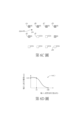
第1A圖為本揭示一實施例之感測裝置1000a的示意圖。如第1A圖所示,感測裝置1000a包括第一感測器100a、第二
感測器200a及運算單元300。感測裝置1000a可對於目標400進行三維(3D)感測以建立相關於目標400的三維資訊。其中,第一感測器100a與第二感測器200a各自得到相關於目標400的不同的深度資訊,運算單元300基於不同的深度資訊執行融合運算(fusion operation)而得到融合深度資訊fD1,據以建立更精準的三維資訊。
Figure 1A is a schematic diagram of a
第一感測器100a產生相關於目標400的複數個第一深度資訊dA~dM。第一感測器100a例如為雷達感測器(對應的第二感測器200a為光達感測器)、利用飛行時間技術(time of flight,ToF)之深度感測器(對應的第二感測器200a為色彩或雙目(stereoscopic)感測器等),等等。其中,利用ToF之深度感測器可利用直接飛行時間技術(direct ToF,dToF)或利用間接飛行時間技術(indirect ToF,iToF)。第一深度資訊dA~dM例如為對應於投影平面的法線方向的絕對或相對之深度資訊,例如為深度圖(depth map)、視差(disparity)資訊、距離資訊、點雲(point cloud)資訊、網格(mesh)資訊,等等。本實施例的第一感測器100a產生法線方向上的第一深度資訊dA~dM。第一深度資訊dA~dM投影於投影平面的第一座標位置A~M,第一深度資訊dA~dM各自對應於第一座標位置A~M。
The
第二感測器200a產生相關於目標400的複數個第二深度資訊da~dn。第二感測器200a例如為光達感測器(對應的第一感測器100a為雷達感測器)、彩色感測器(color sensor)、利
用單目視覺或雙目視覺的感測器,等等。本實施例的第二感測器200a產生第二深度資訊da~dn。第二深度資訊da~dn投影於投影平面的第二座標位置a~n,第二深度資訊da~dn各自對應於第二座標位置a~n。第二感測器200a產生的第二深度資訊da~dn在深度精確度與取樣頻率上不同於第一感測器100a產生的第一深度資訊dA~dM。
The
第1B圖為第1A圖的第一感測器100a產生的第一深度資訊dA~dM及第一座標位置A~M與第二感測器200a產生的第二深度資訊da~dn及第二座標位置a~n的示意圖。如第1B圖所示,第一深度資訊dA~dM投影於投影平面的第一座標位置A~M,第一深度資訊dA~dM對應於投影平面的法線方向。根據第一深度資訊dA~dM與第一座標位置A~M可計算出(x,y,z)三維座標(第1B圖中未顯示),(x,y,z)三維座標涵蓋投影平面及法線方向。在一種示例中,當第一感測器100a產生點雲(points cloud)時,點雲之中的每一點的深度可表示為第一深度資訊dA~dM,每一點可直接對應(x,y,z)三維座標。
Figure 1B shows the first depth information dA~dM and the first coordinate positions A~M generated by the
第一深度資訊dA~dM具有第一精確度及第一取樣頻率。第一精確度的定義為:第一感測器100a在目標400的深度感測的精確度,即,第一深度資訊dA~dM在法線方向的精確度。第一取樣頻率的定義為:第一感測器100a在目標400的投影平面感測上的取樣頻率;即,當第一深度資訊dA~dM投影於投影平面時,第一深度資訊dA~dM在投影平面的等效取樣頻率。第一感測
器100a在深度感測的精確度較高,但第一感測器100a在投影平面的取樣頻率較低,因此,第一深度資訊dA~dM的第一精確度較高但第一取樣頻率較低。
The first depth information dA~dM has a first accuracy and a first sampling frequency. The first accuracy is defined as: the accuracy of the
另一方面,第二感測器200a產生的第二深度資訊da~dn相關於投影平面的法線方向,第二深度資訊da~dn投影於投影平面的第二座標位置a~n。根據第二深度資訊da~dn與第二座標位置a~n可計算出(x,y,z)三維座標。第二深度資訊da~dn具有第二精確度及第二取樣頻率。第二精確度的定義為:第二深度資訊da~dn在法線方向的精確度。第二取樣頻率的定義為:當第二深度資訊da~dn投影於投影平面時,第二深度資訊da~dn在投影平面的等效取樣頻率。第二感測器200a在投影平面的取樣頻率較高,但第二感測器200a在深度感測的精確度較低,因此,第二深度資訊da~dn的第二取樣頻率較高但第二精確度較低。第二深度資訊da~dn的第二取樣頻率大於(或高於)第一深度資訊dA~dM的第一取樣頻率,但第二深度資訊da~dn的第二精確度小於(或低於)第一深度資訊dA~dM的第一精確度。
On the other hand, the second depth information da~dn generated by the
運算單元300根據不同的精確度與取樣頻率之第一深度資訊dA~dM與第二深度資訊da~dn執行融合運算以得到融合深度資訊fD1。融合深度資訊fD1可兼具較高的第一精確度與較高的第二取樣頻率。相較於其他融合技術是以一個物件(例如目標400)為單位執行融合運算,本揭示的感測裝置1000a的運算單元300是以一個深度資訊為單位執行融合運算,例如,以第二深
度資訊da~dn的其中一個第二深度資訊dp為單位執行融合運算。各個深度資訊運算得到的融合深度資訊可統合為整體的融合深度資訊fD1。
The
第2圖為本揭示另一實施例之感測裝置1000b的示意圖。第2圖的感測裝置1000b類似於第1A圖的感測裝置1000a,差異處在於:感測裝置1000b的第一感測器100b與第二感測器200b的其中一者或兩者可產生具體的二維影像。例如,第一感測器100b除了產生法線方向的第一深度資訊dA~dM之外,更可產生對應於第一深度資訊dA~dM的投影平面的第一影像IMG1。即,第一影像IMG1的基準平面大致為第一深度資訊dA~dM的投影平面。第一影像IMG1包括複數個第一像素A”~M”,第一深度資訊dA~dM投影於投影平面的座標位置即為第一像素A”~M”的位置。即,本實施例的第一像素A”~M”的位置大致對應於第1A圖的實施例的第一座標位置A~M。第一深度資訊dA~dM的第一取樣頻率大致相等於第一像素A”~M”在第一影像IMG1之中的解析度對應的取樣頻率。
Figure 2 is a schematic diagram of a
另一方面,第二感測器200b除了產生法線方向的第二深度資訊da~dn之外,更可產生投影平面的第二影像IMG2。第二影像IMG2的基準平面大致為第二深度資訊da~dn的投影平面。第二影像IMG2包括複數個第二像素a”~n”。第二像素a”~n”在投影平面的位置大致對應於第1A圖的實施例的第二座標位置a~n。第二像素a”~n”在第二影像IMG2之中的解析度對應的取樣
頻率大致相等於第二深度資訊da~dn的第二取樣頻率。
On the other hand, in addition to generating the second depth information da~dn in the normal direction, the
本實施例的感測裝置1000b的運作方式類似於第1A圖的感測裝置1000a,其中運算單元300根據第一感測器100b產生的第一深度資訊dA~dM與第二感測器200b產生的第二深度資訊da~dn執行融合運算以得到融合深度資訊fD1。當第1A圖的感測裝置1000a的融合運算使用第1B圖的第一座標位置A~M與第二座標位置a~n時,類似於第2圖的感測裝置1000b的融合運算使用第一像素A”~M”的位置與第二像素a”~n”的位置。
The
於下文中,係以第1A、1B圖的感測裝置1000a為例以說明第3~9圖的融合運算;即,第3~9圖的融合運算是根據第1A、1B圖的第一感測器100a產生的第一深度資訊dA~dM與第一座標位置A~M以及第二感測器200a產生的第二深度資訊da~dn與第二座標位置a~n而執行。
In the following, the
第3、4圖係繪示:根據第二座標位置a~n的其中一個原始座標位置p,對於第二深度資訊dp執行融合運算以得到融合深度資訊dpm。為了使整體的融合深度資訊fD1兼具第二深度資訊da~dn的第二取樣頻率及第一深度資訊dA~dM的第一精確度,將第二深度資訊da~dn映射至第一深度資訊dA~dM以執行融合運算。如第3圖所示,從第二深度資訊da~dn對應的第二座標位置a~n選擇一個第二座標位置p(亦可稱為「原始座標位置p」),並將原始座標位置p映射至第一深度資訊dA~dM對應的第一座標位置A~M之間,而成為映射座標位置pm。在一種示例中,可根
據第一感測器100與第二感測器200各自的複數個內部參數(intrinsic parameters)及/或第一感測器100與第二感測器200之間的複數個外部參數(extrinsic parameters)來計算原始座標位置p與映射座標位置pm之間的映射關係,根據上述的內部參數及/或外部參數將原始座標位置p映射為映射座標位置pm。例如,當第一感測器100的光學中心相異於第二感測器200時,可經由校正而獲得第一感測器100與第二感測器200之間的相關性,據此得到第一感測器100與第二感測器200之間的外部參數。並且,可經由校正或其他演算法獲得第一感測器100與第二感測器200各自的內部參數。
Figures 3 and 4 illustrate: According to one of the original coordinate positions p of the second coordinate positions a~n, a fusion operation is performed on the second depth information dp to obtain the fused depth information dpm. In order to make the overall fused depth information fD1 have both the second sampling frequency of the second depth information da~dn and the first accuracy of the first depth information dA~dM, the second depth information da~dn is mapped to the first depth information dA~dM to perform the fusion operation. As shown in Figure 3, a second coordinate position p (also called "original coordinate position p") is selected from the second coordinate positions a~n corresponding to the second depth information da~dn, and the original coordinate position p is It is mapped to the first coordinate position A~M corresponding to the first depth information dA~dM, and becomes the mapping coordinate position pm. In one example, root
According to a plurality of internal parameters (intrinsic parameters) of the
而後,運算單元300根據與映射座標位置pm從第一座標位置A~M之中選取多個「參與座標位置」,此些參與座標位置鄰近於映射座標位置pm。在一種示例中,可將映射座標位置pm的座標數值進行無條件捨去以得到第一座標位置A,即,第一座標位置A與映射座標位置pm具有最近距離。而後,選取第一座標位置A下方的第一座標位置E,選取第一座標位置A右方的第一座標位置B,選取第一座標位置A右下方的第一座標位置F。所選取的第一座標位置A、B、E、F作為參與座標位置。
Then, the
在另一種示例中,可根據映射座標位置pm定義一參與區域R_pm,位於參與區域R_pm內的第一座標位置被選取為參與座標位置。例如,以映射座標位置pm為圓心,將特定半徑的 圓形區域定義為參與區域R_pm。或者,以映射座標位置pm為幾何中心,將特定長寬的矩形區域定義為參與區域R_pm。 In another example, a participation region R_pm may be defined according to the mapping coordinate position pm, and the first coordinate position located within the participation region R_pm is selected as the participation coordinate position. For example, with the mapping coordinate position pm as the center of the circle, move the The circular area is defined as the participation area R_pm. Or, take the mapping coordinate position pm as the geometric center, and define a rectangular area with a specific length and width as the participation area R_pm.
接著參見第4圖,根據參與座標位置A、B、E、F各自對應的第一深度資訊dA、dB、dE、dF以及原始座標位置p的第二深度資訊dp執行融合運算,以得到映射座標位置pm的融合深度資訊dpm。第一深度資訊dA、dB、dE、dF各自具有權重值,可根據上述權重值執行加權運算以達到上述融合運算。在一種示例中,第一深度資訊dA、dB、dE、dF的權重值為誤差權重weA、weB、weE、weF。以誤差權重weA為例,其計算方式如式(1)所示:weA=we(diffA)=we(|dA-dp|) (1) Next, referring to Figure 4, a fusion operation is performed based on the first depth information dA, dB, dE, dF corresponding to the participating coordinate positions A, B, E, and F and the second depth information dp of the original coordinate position p to obtain the mapping coordinates. Fusion depth information dpm of location pm. The first depth information dA, dB, dE, and dF each have a weight value, and a weighting operation can be performed according to the above weight value to achieve the above fusion operation. In an example, the weight values of the first depth information dA, dB, dE, and dF are error weights weA, weB, weE, and weF. Taking the error weight weA as an example, its calculation method is as shown in equation (1): weA=we(diffA)=we(|dA-dp|) (1)
在式(1)中,絕對誤差值diffA的定義為:第一座標位置A對應的第一深度資訊dA與原始座標位置p對應的第二深度資訊dp之間的差異值的絕對值。絕對誤差值diffA輸入至誤差權重函 數we( ),則誤差權重函數we( )對應輸出誤差權重weA。誤差權重函數we( )例如為線性函數轉換、非線性函數轉換或查表轉換。當輸入的絕對誤差值diffA較小時,誤差權重函數we( )對應輸出較大的誤差權重weA。 In equation (1), the absolute error value diffA is defined as: the absolute value of the difference between the first depth information dA corresponding to the first coordinate position A and the second depth information dp corresponding to the original coordinate position p. The absolute error value diffA is input to the error weight function we(), and the error weight function we() corresponds to the output error weight weA. The error weight function we( ) is, for example, linear function transformation, nonlinear function transformation or look-up table transformation. When the input absolute error value diffA is small, the error weight function we() corresponds to outputting a larger error weight weA.
請參見第5A~5D圖,其繪示誤差權重函數we( )的輸入值-輸出值之對應關係的不同示例。在第5A圖的示例中,誤差權重函數we( )之曲線的中段大致為線性區域,輸入的絕對誤差 值diffA較大,則輸出的誤差權重weA較小。在第5B圖的示例中,誤差權重函數we( )為非線性函數轉換,誤差權重函數we( )為凹曲線(concave)。在第5D圖的示例中,誤差權重函數we( )為凸曲線(convex)。 Please refer to Figures 5A to 5D, which illustrate different examples of the input value-output value correspondence relationship of the error weight function we(). In the example in Figure 5A, the middle section of the curve of the error weight function we() is roughly a linear area, and the absolute error of the input The larger the value diffA is, the smaller the output error weight weA is. In the example of Figure 5B, the error weight function we() is a nonlinear function transformation, and the error weight function we() is a concave curve. In the example of Figure 5D, the error weight function we( ) is a convex curve (convex).
在第5C圖的示例中,誤差權重函數we( )之曲線為為階梯狀線形,階梯的下降邊緣對應於臨界值thd。當絕對誤差值diffA小於臨界值thd時,對應輸出的誤差權重weA為「1」。當絕對誤差值diffA大於臨界值thd時,對應輸出的誤差權重weA為接近於「0」的數值。 In the example of Figure 5C, the curve of the error weight function we() is a stepped line, and the descending edge of the step corresponds to the critical value thd. When the absolute error value diffA is less than the critical value thd, the corresponding output error weight weA is "1". When the absolute error value diffA is greater than the critical value thd, the corresponding output error weight weA is a value close to "0".
類似的,根據式(2)~式(4)分別計算誤差權重weB、weE、weF:weB=we(diffB)=we(|dB-dp|) (2) Similarly, the error weights weB, weE, and weF are calculated respectively according to equations (2) to (4): weB=we(diffB)=we(|dB-dp|) (2)
weE=we(diffE)=we(|dE-dp|) (3) weE=we(diffE)=we(|dE-dp|) (3)
weF=we(diffF)=we(|dF-dp|) (4) weF=we(diffF)=we(|dF-dp|) (4)
而後,根據第一深度資訊dA、dB、dE、dF及對應的誤差權重weA、weB、weE、weF執行加權運算以得到加權運算結果dpm1。第一深度資訊dA、dB、dE、dF的加權運算結果dpm1即為映射座標位置pm的融合深度資訊dpm,如式(5-1)所示:


類似於原始座標位置p對應的映射座標位置pm的融合運算,可對於第二座標位置a~n之中的其他座標位置執行相同的融合運算。第二座標位置a~n的每一者的映射座標位置(圖中未顯示)的融合深度資訊可統合為整體的融合深度資訊fD1。 Similar to the fusion operation of the mapped coordinate position pm corresponding to the original coordinate position p, the same fusion operation can be performed on other coordinate positions among the second coordinate positions a~n. The fusion depth information of the mapping coordinate position (not shown in the figure) of each of the second coordinate positions a~n can be integrated into the overall fusion depth information fD1.
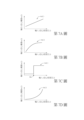
第6A~6D圖為根據參與座標位置A、B、E、F的第一深度資訊及誤差權重執行加權運算以得到映射座標位置pm的融合深度資訊dpm的示意圖。請先參見第6A圖,第二感測器200a產生的第二深度資訊da~dn(對應於第二座標位置a~n)例如具有數值「100」或「990」。第6A圖中繪示為深色網底的第二座標位置對應的第二深度資訊具有數值「100」,繪示為白色網底的第二座標位置對應的第二深度資訊具有數值「990」。第二深度資訊da~dn的第二精確度較低(即,第二深度資訊da~dn的數值「100」或「990」具有誤差),需配合第一深度資訊進行校正。
Figures 6A to 6D are schematic diagrams of performing a weighted operation based on the first depth information and error weights at the participating coordinate positions A, B, E, and F to obtain the fused depth information dpm of the mapped coordinate position pm. Please refer to FIG. 6A first. The second depth information da~dn (corresponding to the second coordinate positions a~n) generated by the
接著,請參見第6C圖,第一感測器100a產生的第一深度資訊dA~dM(對應於第一座標位置A~M)例如具有數值「66」或「1034」。其中,繪示為深色網底的第一座標位置對應的第一深度資訊具有數值「66」,繪示為白色網底的第一座標位置對應的第一深度資訊具有數值「1034」。並且,第6A圖的原始座標位置p映射為第6C圖的映射座標位置pm。
Next, please refer to FIG. 6C. The first depth information dA~dM (corresponding to the first coordinate positions A~M) generated by the
映射座標位置pm鄰近的參與座標位置A、B、E、F對應於第一深度資訊dA、dB、dE、dF。其中,第一深度資訊dA(具有數值「66」)與原始座標位置p的第二深度資訊dp(具有數值「100」)之間的絕對誤差值diffA為「34」。請同時參見第6D圖,當絕對誤差值diffi(i=A)為「34」時,對應的誤差權重wei(i=A)為「0.91」,即,第一深度資訊dA的誤差權重weA為「0.91」。類似的,第一深度資訊dB、dE都具有數值「66」,其絕對誤差值diffi(i=B、E)為「34」,對應的誤差權重wei(i=B、E)為「0.91」。另一方面,第一深度資訊dF為數值「1034」,其絕對誤差值diffi(i=F)為「934」而超過第6D圖所示的輸入上限值「100」。因此對應的誤差權重wei(i=F)為「0」。 Participating coordinate positions A, B, E, and F adjacent to the mapping coordinate position pm correspond to the first depth information dA, dB, dE, and dF. Among them, the absolute error value diffA between the first depth information dA (having the value "66") and the second depth information dp (having the value "100") at the original coordinate position p is "34". Please also refer to Figure 6D. When the absolute error value diffi(i=A) is "34", the corresponding error weight wei(i=A) is "0.91", that is, the error weight weA of the first depth information dA is "0.91". Similarly, the first depth information dB and dE both have the value "66", their absolute error value diffi (i=B, E) is "34", and the corresponding error weight wei (i=B, E) is "0.91" . On the other hand, the first depth information dF is a numerical value "1034", and its absolute error value diffi(i=F) is "934" which exceeds the input upper limit value "100" shown in Figure 6D. Therefore, the corresponding error weight wei (i=F) is "0".
由上,參與座標位置A、B、E、F對應的第一深度資訊dA、dB、dE、dF的誤差權重weA、weB、weE、weF分別為「0.91」、「0.91」、「0.91」、「0」,因此,映射座標位置pm的融合深度資訊dpm可經由式(5-2)的加權運算而得:

根據式(5-2)的加權運算,原始座標位置p對應的第二深度資訊dp(第6A圖所示的數值「100」)校正為第6B圖的融合深度資訊dpm(數值為「66」)。類似的,第6A圖中繪示為白 色網底的第二座標位置的第二深度資訊由原數值「990」校正為第6B圖的數值「1034」。 According to the weighted operation of equation (5-2), the second depth information dp corresponding to the original coordinate position p (the value "100" shown in Figure 6A) is corrected to the fused depth information dpm (the value "66" shown in Figure 6B ). Similarly, shown in Figure 6A is white The second depth information at the second coordinate position at the bottom of the color screen is corrected from the original value "990" to the value "1034" in Figure 6B.
在另一示例中,參與座標位置A、B、E、F的第一深度資訊dA、dB、dE、dF的加權運算結果dpm1可進一步與原始座標位置p的第二深度資訊dp進行加權運算以得到加權運算結果dpm2,加權運算結果dpm2作為最終的融合深度資訊dpm,如式(6)所示:

在式(6)的加權運算中,參與座標位置A、B、E、F對應的第一深度資訊dA、dB、dE、dF具有第一信心權重wc1,其相關於第一深度資訊dA、dB、dE、dF的信心程度(confidence level)CL1(即,可靠程度)。在一種示例中,可根據第一感測器100相關的區塊匹配的成本數值(cost value)來計算第一感測器100的雙目視覺的第一深度資訊的信心程度CL1。其中,相關於第一感測器100的成本數值例如為最小誤差成本數值(minimum cost)、獨特性(uniqueness),等等。在另一種示例中,可根據左右影像檢查(left right check)或雜亂程度檢查來計算第一感測器100的信心程度CL1。在又一種示例中,第一感測器100為ToF感測器,可根據待測目標(例如第1A圖的目標400)的反射光強度來計算ToF感測器的信心程度CL1,反射光強度正比於信心程度CL1的大小。或者,第一感測器100為iToF感測器,則可根據
不同相位的訊號(quad訊號)的相位差與振幅大小來計算iToF感測器的信心程度CL1(相位差對應於距離,振幅大小對應於反射光強度)。第一深度資訊dA、dB、dE、dF的第一信心權重wc1的計算方式如式(7-1)所示:wc1=wc(CL1) (7-1)
In the weighted operation of equation (6), the first depth information dA, dB, dE, and dF corresponding to the participating coordinate positions A, B, E, and F have the first confidence weight wc1, which is related to the first depth information dA, dB. , dE, dF confidence level (confidence level) CL1 (ie, reliability). In one example, the confidence level CL1 of the first depth information of the binocular vision of the
在式(7-1)中,信心程度CL1輸入至信心權重函數wc( ),信心權重函數wc( )對應輸出第一信心權重wc1。參見第7A~7D圖,其繪示信心權重函數wc( )的輸入值-輸出值之對應關係的不同示例。信心權重函數wc( )例如為線性函數轉換、非線性函數轉換或查表轉換。在第7A圖的示例中,信心權重函數wc( )為線性函數轉換,輸入的信心程度CL1較大時,對應輸出的第一信心權重wc1較大。在第7B、7D圖的示例中,信心權重函數wc( )為非線性函數轉換,信心權重函數wc( )為凸曲線(convex)及凹曲線(concave)。在第7C圖的示例中,信心權重函數wc( )為階梯狀線形,階梯的上升邊緣對應於臨界值thc。當輸入的信心程度CL1小於臨界值thc時,輸出的第一信心權重wc1為接近「0」的數值。當輸入的信心程度CL1大於臨界值thc時,輸出的第一信心權重wc1為「1」。 In equation (7-1), the confidence level CL1 is input to the confidence weight function wc( ), and the confidence weight function wc( ) corresponds to the output of the first confidence weight wc1. See Figures 7A to 7D, which illustrate different examples of the input value-output value correspondence relationship of the confidence weight function wc(). The confidence weight function wc( ) is, for example, a linear function transformation, a nonlinear function transformation or a look-up table transformation. In the example in Figure 7A, the confidence weight function wc() is a linear function transformation. When the input confidence level CL1 is larger, the corresponding output first confidence weight wc1 is larger. In the examples in Figures 7B and 7D, the confidence weight function wc( ) is a nonlinear function transformation, and the confidence weight function wc( ) is a convex curve (convex) and a concave curve (concave). In the example of Figure 7C, the confidence weight function wc() is a stepped line, and the rising edge of the step corresponds to the critical value thc. When the input confidence level CL1 is less than the critical value thc, the output first confidence weight wc1 is a value close to "0". When the input confidence level CL1 is greater than the critical value thc, the output first confidence weight wc1 is "1".
類似的,原始座標位置p對應的第二深度資訊dp具有第二信心權重wc2,其相關於第二深度資訊dp的信心程度CL2,如式(7-2)所示: wc2=wc(CL2) (7-2) Similarly, the second depth information dp corresponding to the original coordinate position p has a second confidence weight wc2, which is related to the confidence level CL2 of the second depth information dp, as shown in Equation (7-2): wc2=wc(CL2) (7-2)
由上,根據參與座標位置A、B、C、D的第一深度資訊dA、dB、dE、dF、第一信心權重wc1、原始座標位置p的第二深度資訊dp及第二信心權重wc2執行加權運算,以得到加權運算結果dpm2,加權運算結果dpm2作為最終的融合深度資訊dpm。 From the above, execution is performed based on the first depth information dA, dB, dE, dF of the participating coordinate positions A, B, C, and D, the first confidence weight wc1, the second depth information dp of the original coordinate position p, and the second confidence weight wc2. Weighted operation is performed to obtain the weighted operation result dpm2, and the weighted operation result dpm2 is used as the final fusion depth information dpm.
第8圖繪示:針對原始座標位置p及對應的映射座標位置pm執行融合運算以得到對應的融合深度資訊dpm的一示例。本示例是根據參與座標位置A、B、E、F與映射座標位置pm之間的相對距離來計算第一深度資訊dA、dB、dE、dF的權重值。如第8圖所示,參與座標位置A與映射座標位置pm之間具有相對距離LA、參與座標位置B與映射座標位置pm之間具有相對距離LB、參與座標位置E與映射座標位置pm之間具有相對距離LE、參與座標位置F與映射座標位置pm之間具有相對距離LF。根據相對距離LA、LB、LE、LF以及距離權重函數wd( ),可經由式(8)計算第一深度資訊dA、dB、dE、dF各自的距離權重wdA、wdB、wdE、wdF:wdi=wd(Li),i=A,B,E,F (8) Figure 8 shows an example of performing a fusion operation on the original coordinate position p and the corresponding mapped coordinate position pm to obtain the corresponding fusion depth information dpm. In this example, the weight values of the first depth information dA, dB, dE, and dF are calculated based on the relative distance between the participating coordinate positions A, B, E, and F and the mapping coordinate position pm. As shown in Figure 8, there is a relative distance LA between the participating coordinate position A and the mapping coordinate position pm, a relative distance LB between the participating coordinate position B and the mapping coordinate position pm, and a relative distance LB between the participating coordinate position E and the mapping coordinate position pm. There is a relative distance LE, and there is a relative distance LF between the participating coordinate position F and the mapping coordinate position pm. According to the relative distances LA, LB, LE, LF and the distance weight function wd( ), the distance weights wdA, wdB, wdE, and wdF of the first depth information dA, dB, dE, and dF can be calculated through Equation (8): wdi= wd(Li),i=A,B,E,F (8)
在式(8)中,相對距離Li為距離權重函數wd( )的輸入值,距離權重wdi為距離權重函數wd( )的輸出值。距離權重函數wd( )的輸入值-輸出值的轉換關係類似於第5-1~5-4圖的誤差 權重函數we( )。距離權重函數wd( )例如為線性函數轉換、非線性函數(包括凸曲線、凹曲線或階梯狀線形)轉換或查表轉換。距離權重函數wd( )輸入的相對距離Li較大時,輸出的距離權重wdi較小。即,參與座標位置A、B、E、F與映射座標位置pm相距越遠時,對應的距離權重wdA、wdB、wdE、wdF越小。 In equation (8), the relative distance Li is the input value of the distance weight function wd( ), and the distance weight wdi is the output value of the distance weight function wd( ). The conversion relationship between the input value and the output value of the distance weight function wd( ) is similar to the error in Figures 5-1~5-4 Weight function we(). The distance weight function wd( ) is, for example, linear function transformation, nonlinear function (including convex curve, concave curve or stepped linear shape) transformation or table lookup transformation. When the relative distance Li input to the distance weight function wd() is large, the output distance weight wdi is small. That is, the farther away the participating coordinate positions A, B, E, and F are from the mapping coordinate position pm, the smaller the corresponding distance weights wdA, wdB, wdE, and wdF are.
而後,根據第一深度資訊dA、dB、dE、dF及對應的距離權重wdA、wdB、wdE、wdF與誤差權重weA、weB、weE、weF執行加權運算以得到加權運算結果dpm3。加權運算結果dpm3作為融合深度資訊dpm,如式(9)所示:

第9圖繪示:針對原始座標位置p及對應的映射座標位置pm執行融合運算以得到對應的融合深度資訊dpm的另一示例。本示例是根據參與座標位置A、B、E、F與映射座標位置pm之間的「相對面積」來計算第一深度資訊dA、dB、dE、dF的權重值。更具體而言,以映射座標位置pm為十字線的中心,根據十字線將參與座標位置A、B、E、F包圍的區域切割為四個子區域,每個子區域的面積定義為參與座標位置A、B、E、F與映射座標位置pm之間的「相對面積」。如第9圖所示,參與座標位置A與映射座標位置pm之間具有相對面積AR_A,參與座標位 置B與映射座標位置pm之間具有相對面積AR_B,參與座標位置E與映射座標位置pm之間具有相對面積AR_E,參與座標位置F與映射座標位置pm之間具有相對面積AR_F。根據相對面積AR_A、AR_B、AR_E、AR_F以及面積權重函數wa( ),可經由式(10)計算參與座標位置A、B、E、F各自的面積權重waA、waB、waE、waF:wai=wa(AR_i),i=A,B,E,F (10) Figure 9 shows another example of performing a fusion operation on the original coordinate position p and the corresponding mapped coordinate position pm to obtain the corresponding fusion depth information dpm. This example calculates the weight values of the first depth information dA, dB, dE, and dF based on the "relative area" between the participating coordinate positions A, B, E, and F and the mapping coordinate position pm. More specifically, with the mapping coordinate position pm as the center of the cross line, the area surrounded by the participating coordinate positions A, B, E, and F is cut into four sub-regions according to the cross line, and the area of each sub-region is defined as the participating coordinate position A The "relative area" between , B, E, F and the mapping coordinate position pm. As shown in Figure 9, there is a relative area AR_A between the participating coordinate position A and the mapping coordinate position pm. The participating coordinate position There is a relative area AR_B between the setting B and the mapping coordinate position pm, a relative area AR_E between the participating coordinate position E and the mapping coordinate position pm, and a relative area AR_F between the participating coordinate position F and the mapping coordinate position pm. According to the relative areas AR_A, AR_B, AR_E, AR_F and the area weight function wa( ), the area weights waA, waB, waE, and waF of the participating coordinate positions A, B, E, and F can be calculated through Equation (10): wai=wa (AR_i),i=A,B,E,F (10)
面積權重函數wa( )的輸入值-輸出值的轉換關係類似於距離權重函數wd( )。當參與座標位置A、B、E、F與映射座標位置pm相距較遠時,對應的相對面積AR_i較大,則面積權重函數wa( )輸出的面積權重wai較小。 The input value-output value conversion relationship of the area weight function wa() is similar to the distance weight function wd(). When the participating coordinate positions A, B, E, and F are far away from the mapping coordinate position pm, the corresponding relative area AR_i is larger, and the area weight wai output by the area weight function wa() is smaller.
而後,根據第一深度資訊dA、dB、dE、dF及對應的面積權重waA、waB、waE、waF與誤差權重weA、weB、weE、weF執行加權運算以得到加權運算結果dpm4。加權運算結果dpm3作為融合深度資訊dpm,如式(11)所示:

在另一種示例中,亦可將前述的誤差權重函數we( )、距離權重函數wd( )及面積權重函數wa( )的其中兩者或三者整合 為單一的函數。例如,誤差權重函數we( )與距離權重函數wd( )整合為混合權重函數wm1( )。絕對誤差值diffi以及相對距離Li(其中i=A,B,E,F)為混合權重函數wm1( )的輸入值,混合權重函數wm1( )對應輸出混合權重wm1i,如式(12)所示。當絕對誤差值diffi越大或相對距離Li越大時,輸出的混合權重wm1i越小。 In another example, two or three of the aforementioned error weight function we( ), distance weight function wd( ), and area weight function wa( ) can also be integrated is a single function. For example, the error weight function we() and the distance weight function wd() are integrated into the hybrid weight function wm1(). The absolute error value diffi and the relative distance Li (where i=A, B, E, F) are the input values of the hybrid weight function wm1( ), and the hybrid weight function wm1( ) corresponds to the output hybrid weight wm1i, as shown in Equation (12) . When the absolute error value diffi is larger or the relative distance Li is larger, the output mixing weight wm1i is smaller.
wm1i=wm1(Li,diffi)i=A,B,E,F (12) wm1i=wm1(Li,diffi)i=A,B,E,F (12)
或者,誤差權重函數we( )與面積權重函數wa( )整合為混合權重函數wm2( )。絕對誤差值diffi與相對面積AR_i(其中i=A,B,E,F)為混合權重函數wm2( )的輸入值,混合權重函數wm2( )對應輸出混合權重wm2i,如式(13)所示:wm2i=wm2(AR_i,diffi)i=A,B,E,F (13) Or, the error weight function we() and the area weight function wa() are integrated into the hybrid weight function wm2(). The absolute error value diffi and the relative area AR_i (where i=A, B, E, F) are the input values of the hybrid weight function wm2( ), and the hybrid weight function wm2( ) corresponds to the output hybrid weight wm2i, as shown in Equation (13) :wm2i=wm2(AR_i,diffi)i=A,B,E,F (13)
在另一種示例中,可藉由權重選擇函數W(i1,i2,...,in)以賦予第一深度資訊dA、dB、dE、dF各自的權重值wA、wB、wE、wF。權重選擇函數W(i1,i2,...,in)具有多個輸入值i1~in,輸入值i1~in之間具有關聯性而非各自獨立。權重選擇函數W(i1,i2,...,in)可根據輸入值i1~in進行綜合判斷,據以輸出權重值wA、wB、wE、wF。例如,當輸入值i1~in整體滿足一特定條件時,輸出的權重值wA、wB、wE、wF為「1」、「0」、「0」、「0」。此時,僅有權重值wA為「1」,因此僅選擇第一深度資訊dA計算融合深度資訊dpm。又例如,當輸入值i1~in整體滿足另一特定條件時,輸出的權重值wA、wB、wE、 wF為「0」、「0」、「1」、「1」。此時,選擇第一深度資訊dE與第一深度資訊dF計算融合深度資訊dpm。由上,在一些示例中,可藉由權重選擇函數W(i1,i2,...,in)選擇第一深度資訊dA、dB、dE、dF其中的一者或多者計算融合深度資訊dpm。 In another example, the first depth information dA, dB, dE, and dF can be given respective weight values wA, wB, wE, and wF through the weight selection function W(i1, i2,...,in). The weight selection function W(i1,i2,...,in) has multiple input values i1~in, and the input values i1~in are related rather than independent. The weight selection function W(i1,i2,...,in) can make a comprehensive judgment based on the input values i1~in, and output the weight values wA, wB, wE, and wF accordingly. For example, when the input values i1~in all meet a specific condition, the output weight values wA, wB, wE, and wF are "1", "0", "0", and "0". At this time, only the weight value wA is "1", so only the first depth information dA is selected to calculate the fusion depth information dpm. For another example, when the input value i1~in as a whole meets another specific condition, the output weight values wA, wB, wE, wF is "0", "0", "1", "1". At this time, the first depth information dE and the first depth information dF are selected to calculate the fused depth information dpm. From the above, in some examples, one or more of the first depth information dA, dB, dE, dF can be selected by the weight selection function W(i1,i2,...,in) to calculate the fused depth information dpm .
於上文中,第3~9圖的融合運算亦可藉由第2圖的感測裝置1000b而實施。當第2圖的感測裝置1000b實施第3~9圖的融合運算時,係將第一座標位置A~M與第二座標位置a~n分別置換為第一像素A”~M”的位置與第二像素a”~n”的位置,可得到大致相同的融合運算的結果。
In the above, the fusion operations in Figures 3 to 9 can also be implemented by the
第10A~10D圖為對於融合深度資訊進行校正的示意圖。可將第1B圖的第二座標位置a~n區分為多個區塊,例如,五個第二座標位置a、b、c、d、e屬於同一個區塊,同一個區塊內對應的第二深度資訊da、db、dc、dd、de進行加權運算。請先參見第10A圖,對於第二深度資訊da、db、dc、dd、de先進行加權運算以得到基準值dw1。例如,加權運算為平均值運算,則基準值dw1為第二深度資訊da、db、dc、dd、de的平均值。 Figures 10A to 10D are schematic diagrams of correction of fused depth information. The second coordinate positions a~n in Figure 1B can be divided into multiple blocks. For example, the five second coordinate positions a, b, c, d, and e belong to the same block, and the corresponding positions in the same block The second depth information da, db, dc, dd, de are subjected to weighted operation. Please refer to Figure 10A first. For the second depth information da, db, dc, dd, de, a weighted operation is first performed to obtain the reference value dw1. For example, if the weighting operation is an average operation, then the reference value dw1 is the average of the second depth information da, db, dc, dd, and de.
接著參見第10B圖,將第二深度資訊da、db、dc、dd、de分別減去基準值dw1,以得到相對於基準值dw1的偏移值da’、db’、dc’、dd’、de’。例如,第二深度資訊da、db、dc、dd、de的數值分別為「100」、「100」、「150」、「150」、「150」,平均值運算的基準值dw1為「130」,對應的偏移值da’、db’、dc’、dd’、de’分別為「-30」、「-30」、「20」、「20」、「20」。 Next, referring to Figure 10B, the second depth information da, db, dc, dd, de are respectively subtracted from the reference value dw1 to obtain the offset values da', db', dc', dd', de'. For example, the values of the second depth information da, db, dc, dd, and de are "100", "100", "150", "150", and "150" respectively, and the reference value dw1 for the average calculation is "130" , the corresponding offset values da', db', dc', dd', de' are "-30", "-30", "20", "20", and "20" respectively.
接著參見第10C圖,針對第二座標位置a、b、c、d、e各自的映射座標位置執行融合運算,以得到融合深度資訊dam、dbm、dcm、ddm、dem。而後,根據第10B圖的偏移值da’、db’、dc’、dd’、de’對於第10C圖的融合深度資訊dam、dbm、dcm、ddm、dem進行校正;例如,將融合深度資訊dam、dbm、dcm、ddm、dem分別加上偏移值da’、db’、dc’、dd’、de’,以得到第10D圖的校正後的融合深度資訊dam’、dbm’、dcm’、ddm’、dem’。 Next, referring to Figure 10C, a fusion operation is performed on the respective mapping coordinate positions of the second coordinate positions a, b, c, d, and e to obtain the fused depth information dam, dbm, dcm, ddm, and dem. Then, the fused depth information dam, dbm, dcm, ddm, and dem in Figure 10C are corrected according to the offset values da', db', dc', dd', and de' in Figure 10B; for example, the fused depth information is Add offset values da', db', dc', dd', de' respectively to dam, dbm, dcm, ddm and dem to obtain the corrected fusion depth information dam', dbm' and dcm' of the 10D picture. ,ddm',dem'.
在校正後的融合深度資訊dbm’與融合深度資訊dcm’之間呈現出數值上升趨勢,可反映出第10A圖的原始的第二深度資訊db與第二深度資訊dc之間的數值上升趨勢。 There is a numerical upward trend between the corrected fused depth information dbm’ and the fused depth information dcm’, which can reflect the numerical upward trend between the original second depth information db and the second depth information dc in Figure 10A.
第11圖為本揭示另一實施例的感測裝置1000c的示意圖。如第11圖所示,感測裝置1000c的第一感測器100c類似於第1A圖的實施例的第一感測器100a,本實施例的第一感測器100c用以產生相關於目標400的複數個第一深度資訊dA、dB、dE、dF、...等等,其投影於投影平面的第一座標位置A、B、C、D、...等等。本實施例的第一感測器100c產生第一深度資訊dA、dB、dE、dF具有第一精確度及第一取樣頻率。
Figure 11 is a schematic diagram of a
另一方面,本實施例的第二感測器200c相異於第1A圖的第二感測器200a與第2圖的第二感測器200b,本實施例的第二感測器200c不產生任何深度資訊。本實施例的第二感測器200c例如為影像擷取裝置,可產生相關於目標400的影像IMG2’。
影像IMG2’包括複數個像素a”、b”、e”、f”、...等等,像素a”、b”、e”、f”具有影像值Ya”、Yb”、Ye”、Yf”。影像值Ya”、Yb”、Ye”、Yf”例如為色彩灰階值或色彩索引值。影像IMG2’具有一解析度,該解析度對應的取樣頻率大於第一深度資訊dA、dB、dE、dF的第一取樣頻率。
On the other hand, the
運算單元300c根據第一深度資訊dA、dB、dE、dF及影像值Ya、Yb、Ye、Yf執行融合運算,以得到各像素對應的融合深度資訊。各融合深度資訊可統合為整體的融合深度資訊fD2,融合深度資訊fD2能夠兼具第一深度資訊dA、dB、dE、dF的第一精確度與影像IMG2’的解析度對應的取樣頻率。
The
第12A、12B圖為第11圖的感測裝置1000c執行融合運算的示意圖。請先參見第12A圖,第一感測器100c產生的第一深度資訊dA~dF在投影平面的第一取樣頻率小於第二感測器200c產生的影像IMG2’的解析度對應的取樣頻率。為了使融合深度資訊fD2達到影像IMG2’的解析度對應的取樣頻率,運算單元300c在第一座標位置A、B、E、F之間取樣(sample)更多的座標位置。例如,影像IMG2’的解析度對應的取樣頻率為第一深度資訊dA~dF的第一取樣頻率的3倍,運算單元300c在4個原始的第一座標位置A、B、E、F之間建立12個新增的取樣座標位置,其中包括取樣座標位置G。新增的取樣座標位置G位於原始的第一座標位置A、B、E、F之間。
Figures 12A and 12B are schematic diagrams of the
請參見第12B圖,根據第一感測器100c與第二感測器200c的內部參數及/或外部參數,運算單元300c可將第一座標位置A、B、E、F映射至影像IMG2’之中的主要映射座標位置a’、b’、e’、f’。並且,將取樣座標位置G映射至影像IMG2’之中的取樣映射座標位置g’。在一種示例中,運算單元300c可將取樣座標位置G與第一座標位置A~F的相對位置的比例關係套用至影像IMG2’,再根據主要映射座標位置a’、b’、e’、f’的相對位置計算取樣映射座標位置g’。在另一種示例中,可根據單應性(homography)計算取樣映射座標位置g’。
Please refer to Figure 12B. According to the internal parameters and/or external parameters of the
由於主要映射座標位置a’、b’、e’、f’與取樣映射座標位置g’不一定重疊於影像IMG2’的原始之像素a”、b”、e”、f”、g”,因此無法直接利用原始之像素a”、b”、e”、f”、g”對應的影像值Ya”、Yb”、Ye”、Yf”、Yg”。必須執行內插運算以得到主要映射座標位置a’、b’、e’、f’與取樣映射座標位置g’對應的影像值。例如,從影像IMG2’之原始的像素之中選取複數個鄰近像素q、s、r、t,此些鄰近像素q、s、r、t鄰近於取樣映射座標位置g’。而後,根據鄰近像素q、s、r、t對應的影像值Yq、Ys、Yr、Yt執行內插運算,以得到取樣映射座標位置g’的影像值Yg’。 Since the main mapping coordinate positions a', b', e', f' and the sampling mapping coordinate position g' do not necessarily overlap with the original pixels a", b", e", f", g" of the image IMG2', therefore The image values Ya", Yb", Ye", Yf", Yg" corresponding to the original pixels a", b", e", f", g" cannot be directly used. Interpolation operations must be performed to obtain the main mapping coordinate positions The image values corresponding to a', b', e', f' and the sampling mapping coordinate position g'. For example, select a plurality of adjacent pixels q, s, r, t from the original pixels of the image IMG2', these Neighboring pixels q, s, r, t are adjacent to the sampling map coordinate position g'. Then, an interpolation operation is performed based on the image values Yq, Ys, Yr, Yt corresponding to the neighboring pixels q, s, r, t to obtain the sampling map Image value Yg' of coordinate position g'.
類似的,亦選取主要映射座標位置a’的鄰近像素(圖中未顯示),根據鄰近像素對應的影像值執行內插運算,以得到主 要映射座標位置a’對應的影像值Ya’。以類似的內插運算得到主要映射座標位置b’、e’、f’對應的影像值Yb’、Ye’、Yf’。 Similarly, the neighboring pixels (not shown in the figure) of the main mapping coordinate position a' are also selected, and an interpolation operation is performed based on the image values corresponding to the neighboring pixels to obtain the main To map the image value Ya’ corresponding to the coordinate position a’. Similar interpolation operations are used to obtain the image values Yb’, Ye’, and Yf’ corresponding to the main mapping coordinate positions b’, e’, and f’.
請再次參見第12A圖,第一深度資訊dA~dF各自具有權重值。根據第一深度資訊dA~dF與其對應的權重值執行加權運算,以得到取樣座標位置G的融合深度資訊dG。在一種示例中,第一深度資訊dA、dB、dE、dF的權重值為誤差權重weA、weB、weE、weF,並且誤差權重weA、weB、weE、weF相關於影像值誤差|(Yg'-Ya')|、|(Yg'-Yb')|、|(Yg'-Ye')|、|(Yg'-Yf')|。其中,影像值誤差|(Yg'-Ya')|為主要映射座標位置a’對應的影像值Ya’及取樣映射座標位置g’對應的影像值Yg’之間的差異值的絕對值,依此類推。將影像值誤差|(Yg'-Ya')|、|(Yg'-Yb')|、|(Yg'-Ye')|、|(Yg'-Yf')|輸入至誤差權重函數we( )以產生誤差權重weA、weB、weE、weF,如式(14)所示:wej=we(|(Yg'-Yi')|)j=A,B,E,F i=a,b,e,f (14) Please refer to Figure 12A again. The first depth information dA~dF each has a weight value. A weighting operation is performed according to the first depth information dA~dF and its corresponding weight value to obtain the fused depth information dG of the sampling coordinate position G. In an example, the weight values of the first depth information dA, dB, dE, dF are error weights weA, weB, weE, weF, and the error weights weA, weB, weE, weF are related to the image value error |(Yg ' - Ya ' )|, |(Yg ' -Yb ' )|, |(Yg ' -Ye ' )|, |(Yg ' -Yf ' )|. Among them, the image value error |(Yg ' -Ya ' )| is the absolute value of the difference between the image value Ya' corresponding to the main mapping coordinate position a' and the image value Yg' corresponding to the sampling mapping coordinate position g', according to And so on. Input the image value errors |(Yg ' -Ya ' )|, |(Yg ' -Yb ' )|, |(Yg ' -Ye ' )|, |(Yg ' -Yf ' )| into the error weight function we( ) to generate error weights weA, weB, weE, weF, as shown in equation (14): wej=we(|(Yg ' -Yi ' )|)j=A,B,E,F i=a,b, e,f (14)
而後,根據誤差權重weA、weB、weE、weF執行第一深度資訊dA、dB、dE、dF的加權運算以得到取樣座標位置G的融合深度資訊dG,如式(15)所示:

類似的,對於取樣座標位置G之外的其他11個取樣座標位置(第12A圖中繪示為深色網底的座標位置)亦執行相同的融合運算以得到各自對應的融合深度資訊。各個融合深度資訊統合為整體的融合深度資訊fD2。 Similarly, the same fusion operation is performed for the other 11 sampling coordinate positions other than the sampling coordinate position G (shown as the coordinate positions at the bottom of the dark screen in Figure 12A) to obtain their corresponding fusion depth information. Each fusion depth information is integrated into the overall fusion depth information fD2.
在一種示例中,當第一座標位置A~F排列為矩形時,影像IMG2’對應的主要映射座標位置a’~f’亦排列為矩形,則取樣映射座標位置g’的內插運算可較為精簡。在另一種示例中(未顯示於第12A、12B圖),可預先將第一座標位置A~F經由深度影像繪圖(depth image based rendering,DIBR)轉換為轉換影像IMG1_t。轉換影像IMG1_t的光學中心相同於第二感測器200c的光學中心,因此轉換影像IMG1_t可線性對應於影像IMG2’,即,轉換影像IMG1_t相對於影像IMG2’僅為尺寸的縮放。據此,亦能夠由影像IMG2’反方向地映射至轉換影像IMG1_t。
In an example, when the first coordinate positions A~F are arranged in a rectangle, the main mapping coordinate positions a'~f' corresponding to the image IMG2' are also arranged in a rectangle, then the interpolation operation of the sampling mapping coordinate position g' can be compared to Streamlined. In another example (not shown in Figures 12A and 12B), the first coordinate positions A~F can be converted into the converted image IMG1_t through depth image based rendering (DIBR) in advance. The optical center of the converted image IMG1_t is the same as the optical center of the
第13圖為本揭示又一實施例的感測裝置1000c的示意圖。相較於第1A圖的實施例的感測裝置1000包括第一感測器100及第二感測器200,本實施例的感測裝置1000c僅包括第一感測器100c而不包括其他的感測器。第一感測器100c對於目標400進行感測,以產生複數個第一深度資訊dAi、dBi、dCi。在一種示例中,第一深度資訊dAi、dBi、dCi是第一感測器100c在不同的時間點ti所產生的。運算單元300c對於第一深度資訊dAi、dBi、dCi進行處理,並且執行融合運算,最終產生融合深度資訊fD3。
Figure 13 is a schematic diagram of a
第14圖為第13圖的感測裝置1000c執行融合運算的示意圖。如第14圖所示,第一感測器100c在時間點t1感測得到第一深度資訊dA1、dB1、dC1,在時間點t2感測得到第一深度資訊dA2、dB2、dC2,在時間點t3感測得到第一深度資訊dA3、dB3、dC3。在一種示例中,在不同的時間點ti產生的第一深度資訊dAi、dBi、dCi皆相關於相同的第一空間SP1,第一空間SP1具有複數個第一座標位置A、B、C,第一深度資訊dAi、dBi、dCi分別對應於第一座標位置A、B、C。
Figure 14 is a schematic diagram of the
在另一種示例中,在不同的時間點ti感測得到的第一深度資訊dAi、dBi、dCi可能相關於不同的座標空間。例如,在時間點t1感測得到第一深度資訊dA1、dB1、dC1相關於第一空間SP1’,在時間點t2感測得到第一深度資訊dA2、dB2、dC2相關於第二空間SP2’,在時間點t3感測得到第一深度資訊dA3、dB3、dC3相關於第三空間SP3’。 In another example, the first depth information dAi, dBi, and dCi sensed at different time points ti may be related to different coordinate spaces. For example, at time point t1, the first depth information dA1, dB1, and dC1 are sensed and related to the first space SP1', and at time point t2, the first depth information dA2, dB2, and dC2 are sensed and related to the second space SP2', At time point t3, the first depth information dA3, dB3, and dC3 are sensed and related to the third space SP3'.
另一方面,標準空間SP0是對應於真實世界的座標空間,即,標準空間SP0為統一座標系或世界座標系。標準空間SP0與第一空間SP1(或第一空間SP1’、第二空間SP2’、第三空間SP3’)之間具有空間轉換的對應關係或映射關係。運算單元300c根據標準空間SP0與第一空間SP1(或第一空間SP1’、第二空間SP2’、第三空間SP3’)之間的空間轉換將第一深度資訊dAi、dBi、dCi轉換為標準空間SP0的第二深度資訊da、db、dc。標準空間SP0具有至少一個第二座標位置(例如,第二座標位置e)。
On the other hand, the standard space SP0 is a coordinate space corresponding to the real world, that is, the standard space SP0 is a unified coordinate system or a world coordinate system. There is a spatial transformation correspondence or mapping relationship between the standard space SP0 and the first space SP1 (or the first space SP1', the second space SP2', and the third space SP3'). The
運算單元300c判斷多個第二深度資訊da、db、dc是否指向第二座標位置的相同一者。例如,當第二深度資訊da、db、dc皆指向相同的第二座標位置e時,表示第二深度資訊da、db、dc皆指向真實世界的座標空間的相同物理位置,則運算單元300c根據第二深度資訊da、db、dc執行融合運算以得到第二座標位置e的融合深度資訊de。
The
運算單元300c執行的融合運算例如為:根據第二深度資訊da、db、dc及對應的權重值執行的加權運算。第二深度資訊da、db、dc及對應的權重值例如為為信心權重wca、wcb、wcc,可藉由類似於式(7-1)的信心權重函數wc( )來計算信心權重wca、wcb、wcc。第二深度資訊da、db、dc各自具有信心程度CLa、CLb、CLc,其相關於第一感測器100c的區塊匹配的成本數值或目標400的反射光強度。信心程度CLa、CLb、CLc分別輸入至信心權重函數wc( )而對應輸出信心權重wca、wcb、wcc。信心權重函數wc( )例如為線性函數轉換、非線性函數轉換或查表轉換,輸入的信心程度CLa、CLb、CLc較大時,對應輸出的信心權重wca、wcb、wcc較大。
The fusion operation performed by the
而後,根據信心權重wca、wcb、wcc對於第二深度資訊da、db、dc執行加權運算,以得到第二座標位置e的融合深度資訊de,如式(16)所示:

基於相同的融合運算的機制,計算標準空間SP0的其他的座標位置的融合深度資訊。標準空間SP0的各個座標位置的融合深度資訊統合為整體的融合深度資訊fD3。 Based on the same fusion operation mechanism, the fusion depth information of other coordinate positions in the standard space SP0 is calculated. The fused depth information of each coordinate position in the standard space SP0 is integrated into the overall fused depth information fD3.
第15圖為本揭示再一實施例的感測裝置1000d的示意圖。相較於第13圖的實施例的感測裝置1000c僅包括一個第一感測器100c,本實施例的感測裝置1000d包括多個感測器,例如包括三個感測器100-1、100-2、100-3。第16圖為第15圖的感測裝置1000d執行融合運算的示意圖。請同時參見第15、16圖,以同一個第一座標位置A為例進行說明,感測器100-1、100-2、100-3分別得到第一座標位置A的多個第一深度資訊。例如,感測器100-1感測得到第一座標位置A的第一深度資訊dA-1,感測器100-2感測得到第一座標位置A的第一深度資訊dA-2感測器100-3感測得到第一座標位置A的第一深度資訊dA-3。
Figure 15 is a schematic diagram of a
在一種示例中,感測器100-1、100-2、100-3產生的第一深度資訊dA-1、dA-2、dA-3皆相關於相同的一個座標空間,例如,第一深度資訊dA-1、dA-2、dA-3皆相關於相同的第一空間SP1。運算單元300d將第一深度資訊dA-1、dA-2、dA-3轉換為標準中間SP0的第二深度資訊da-1、da-2、da-3。
In one example, the first depth information dA-1, dA-2, and dA-3 generated by the sensors 100-1, 100-2, and 100-3 are all related to the same coordinate space, for example, the first depth Information dA-1, dA-2, and dA-3 are all related to the same first space SP1. The
在另一種示例中,感測器100-1、100-2、100-3產生的第一深度資訊dA-1、dA-2、dA-3相關於不同的座標空間。例如,感測器100-1產生的第一深度資訊dA1相關於第一空間
SP1’,感測器100-2產生的第一深度資訊dA2相關於第二空間SP2’,感測器100-3產生的第一深度資訊dA3相關於第三空間SP3’。運算單元300d將第一空間SP1’的第一深度資訊dA-1、第二空間SP2’的第一深度資訊dA-2、第三空間SP3’的第一深度資訊dA-3轉換為標準空間SP0的第二深度資訊da-1、da-2、da-3。
In another example, the first depth information dA-1, dA-2, and dA-3 generated by the sensors 100-1, 100-2, and 100-3 are related to different coordinate spaces. For example, the first depth information dA1 generated by the sensor 100-1 is related to the first spatial
SP1', the first depth information dA2 generated by the sensor 100-2 is related to the second space SP2', and the first depth information dA3 generated by the sensor 100-3 is related to the third space SP3'. The
當第二深度資訊da-1、da-2、da-3皆指向標準空間SP0的相同的第二座標位置e時,運算單元300c根據第二深度資訊da、db、dc及對應的信心權重wca1、wca2、wca3執行加權運算,以得到第二座標位置e的融合深度資訊de,如式(17)所示:

類似的,標準空間SP0的各個座標位置的融合深度資訊統合為整體的融合深度資訊fD4。 Similarly, the fused depth information of each coordinate position in the standard space SP0 is integrated into the overall fused depth information fD4.
雖然本發明已以較佳實施例及範例詳細揭示如上,可理解的是,此些範例意指說明而非限制之意義。可預期的是,所屬技術領域中具有通常知識者可想到多種修改及組合,其多種修改及組合落在本發明之精神以及後附之申請專利範圍之範圍內。 Although the present invention has been disclosed in detail above with preferred embodiments and examples, it should be understood that these examples are meant to be illustrative rather than limiting. It is expected that those with ordinary skill in the art can think of various modifications and combinations, and the various modifications and combinations fall within the spirit of the present invention and the scope of the appended patent application.
1000a:感測裝置 1000a: Sensing device
100a:第一感測器 100a: first sensor
200a:第二感測器 200a: Second sensor
300:運算單元 300:Arithmetic unit
400:目標 400: target
A~M:第一座標位置 A~M: first coordinate position
dA~dM:第一深度資訊 dA~dM: The first in-depth information
a~n:第二座標位置 a~n: second coordinate position
da~dn:第二深度資訊 da~dn: second in-depth information
fD1:融合深度資訊 fD1: Fusion of depth information
Claims (20)
Priority Applications (1)
| Application Number | Priority Date | Filing Date | Title |
|---|---|---|---|
| US17/965,912 US20230377181A1 (en) | 2022-05-19 | 2022-10-14 | Sensing device for providing three dimensional information |
Applications Claiming Priority (2)
| Application Number | Priority Date | Filing Date | Title |
|---|---|---|---|
| US202263343547P | 2022-05-19 | 2022-05-19 | |
| US63/343,547 | 2022-05-19 |
Publications (2)
| Publication Number | Publication Date |
|---|---|
| TW202347257A TW202347257A (en) | 2023-12-01 |
| TWI830363B true TWI830363B (en) | 2024-01-21 |
Family
ID=88791772
Family Applications (3)
| Application Number | Title | Priority Date | Filing Date |
|---|---|---|---|
| TW111133877A TWI830363B (en) | 2022-05-19 | 2022-09-07 | Sensing device for providing three dimensional information |
| TW111139055A TWI822394B (en) | 2022-05-19 | 2022-10-14 | Data processing method and data processing system |
| TW112116628A TW202348025A (en) | 2022-05-19 | 2023-05-04 | Calibration system and calibration method for multi-camera system |
Family Applications After (2)
| Application Number | Title | Priority Date | Filing Date |
|---|---|---|---|
| TW111139055A TWI822394B (en) | 2022-05-19 | 2022-10-14 | Data processing method and data processing system |
| TW112116628A TW202348025A (en) | 2022-05-19 | 2023-05-04 | Calibration system and calibration method for multi-camera system |
Country Status (2)
| Country | Link |
|---|---|
| US (1) | US20230377091A1 (en) |
| TW (3) | TWI830363B (en) |
Citations (4)
| Publication number | Priority date | Publication date | Assignee | Title |
|---|---|---|---|---|
| CN105492985A (en) * | 2014-09-05 | 2016-04-13 | 深圳市大疆创新科技有限公司 | Multi-sensor environment map building |
| CN107223275A (en) * | 2016-11-14 | 2017-09-29 | 深圳市大疆创新科技有限公司 | The method and system of multichannel sensing data fusion |
| TW202014990A (en) * | 2018-10-09 | 2020-04-16 | 財團法人工業技術研究院 | Depth estimation apparatus, autonomous vehicle using the same, and depth estimation method thereof |
| US20220107398A1 (en) * | 2019-04-18 | 2022-04-07 | Beijing Kuangshi Technology Co., Ltd. | Method for controlling working frequency of tof sensor, and apparatus, device, and medium |
Family Cites Families (8)
| Publication number | Priority date | Publication date | Assignee | Title |
|---|---|---|---|---|
| US6208772B1 (en) * | 1997-10-17 | 2001-03-27 | Acuity Imaging, Llc | Data processing system for logically adjacent data samples such as image data in a machine vision system |
| JP5446282B2 (en) * | 2009-01-21 | 2014-03-19 | ソニー株式会社 | Solid-state imaging device and camera system |
| JP5847940B2 (en) * | 2012-07-19 | 2016-01-27 | 株式会社日立製作所 | Semiconductor device |
| JP6239993B2 (en) * | 2014-02-07 | 2017-11-29 | オリンパス株式会社 | Imaging device, display device, and control method |
| KR20170027922A (en) * | 2015-09-02 | 2017-03-13 | 삼성전자주식회사 | Memory system including plural memory device forming plural ranks and memory controller and operating method of memory system |
| US20170242785A1 (en) * | 2016-02-23 | 2017-08-24 | Sandisk Technologies Llc | Efficient Implementation of Optimized Host-Based Garbage Collection Strategies Using Xcopy and Arrays of Flash Devices |
| WO2017156705A1 (en) * | 2016-03-15 | 2017-09-21 | Mediatek Inc. | Affine prediction for video coding |
| JP6765322B2 (en) * | 2017-02-28 | 2020-10-07 | キオクシア株式会社 | Memory system and control method |
-
2022
- 2022-09-07 TW TW111133877A patent/TWI830363B/en active
- 2022-10-14 US US17/965,817 patent/US20230377091A1/en active Pending
- 2022-10-14 TW TW111139055A patent/TWI822394B/en active
-
2023
- 2023-05-04 TW TW112116628A patent/TW202348025A/en unknown
Patent Citations (4)
| Publication number | Priority date | Publication date | Assignee | Title |
|---|---|---|---|---|
| CN105492985A (en) * | 2014-09-05 | 2016-04-13 | 深圳市大疆创新科技有限公司 | Multi-sensor environment map building |
| CN107223275A (en) * | 2016-11-14 | 2017-09-29 | 深圳市大疆创新科技有限公司 | The method and system of multichannel sensing data fusion |
| TW202014990A (en) * | 2018-10-09 | 2020-04-16 | 財團法人工業技術研究院 | Depth estimation apparatus, autonomous vehicle using the same, and depth estimation method thereof |
| US20220107398A1 (en) * | 2019-04-18 | 2022-04-07 | Beijing Kuangshi Technology Co., Ltd. | Method for controlling working frequency of tof sensor, and apparatus, device, and medium |
Also Published As
| Publication number | Publication date |
|---|---|
| TW202348018A (en) | 2023-12-01 |
| TW202347258A (en) | 2023-12-01 |
| TW202347257A (en) | 2023-12-01 |
| TWI822394B (en) | 2023-11-11 |
| TW202348025A (en) | 2023-12-01 |
| US20230377091A1 (en) | 2023-11-23 |
Similar Documents
| Publication | Publication Date | Title |
|---|---|---|
| CN104023220B (en) | Real-time multi views synthesizer | |
| JP5442111B2 (en) | A method for high-speed 3D construction from images | |
| JP6883608B2 (en) | Depth data processing system that can optimize depth data by aligning images with respect to depth maps | |
| WO2022127918A1 (en) | Stereo calibration method, apparatus, and system for binocular camera, and binocular camera | |
| JP5633058B1 (en) | 3D measuring apparatus and 3D measuring method | |
| CN113034568B (en) | Machine vision depth estimation method, device and system | |
| TW202008780A (en) | Augmented reality system and color compensation method thereof | |
| JP2018514237A (en) | Texture mapping apparatus and method for dental 3D scanner | |
| WO2021203883A1 (en) | Three-dimensional scanning method, three-dimensional scanning system, and computer readable storage medium | |
| CN106170086B (en) | Method and device thereof, the system of drawing three-dimensional image | |
| CN105026997A (en) | Projection system, semiconductor integrated circuit, and image correction method | |
| CN110390719A (en) | Based on flight time point cloud reconstructing apparatus | |
| JP2011060216A (en) | Device and method of processing image | |
| KR20050058085A (en) | 3d scene model generation apparatus and method through the fusion of disparity map and depth map | |
| JP2009116532A (en) | Method and apparatus for generating virtual viewpoint image | |
| JP2013127774A (en) | Image processing device, image processing method, and program | |
| CN103299343A (en) | Range image pixel matching method | |
| JP2019100995A (en) | Measurement image display control unit, measurement image display control method, and program for measurement image display control | |
| CN113643436B (en) | Depth data splicing and fusion method and device | |
| WO2021143127A1 (en) | Parallax correction method and device, and storage medium | |
| KR101631514B1 (en) | Apparatus and method for generating three demension content in electronic device | |
| US20230062973A1 (en) | Image processing apparatus, image processing method, and storage medium | |
| CN113643414A (en) | Three-dimensional image generation method and device, electronic equipment and storage medium | |
| TWI820246B (en) | Apparatus with disparity estimation, method and computer program product of estimating disparity from a wide angle image | |
| JP4193292B2 (en) | Multi-view data input device |