KR20110080098A - Augmented reality service apparatus using location based data and method the same - Google Patents
Augmented reality service apparatus using location based data and method the same Download PDFInfo
- Publication number
- KR20110080098A KR20110080098A KR1020100000273A KR20100000273A KR20110080098A KR 20110080098 A KR20110080098 A KR 20110080098A KR 1020100000273 A KR1020100000273 A KR 1020100000273A KR 20100000273 A KR20100000273 A KR 20100000273A KR 20110080098 A KR20110080098 A KR 20110080098A
- Authority
- KR
- South Korea
- Prior art keywords
- location
- information
- augmented reality
- camera
- feature point
- Prior art date
Links
Images


Classifications
-
- H—ELECTRICITY
- H04—ELECTRIC COMMUNICATION TECHNIQUE
- H04W—WIRELESS COMMUNICATION NETWORKS
- H04W4/00—Services specially adapted for wireless communication networks; Facilities therefor
- H04W4/02—Services making use of location information
- H04W4/029—Location-based management or tracking services
-
- G—PHYSICS
- G06—COMPUTING; CALCULATING OR COUNTING
- G06T—IMAGE DATA PROCESSING OR GENERATION, IN GENERAL
- G06T7/00—Image analysis
- G06T7/70—Determining position or orientation of objects or cameras
- G06T7/73—Determining position or orientation of objects or cameras using feature-based methods
-
- G—PHYSICS
- G06—COMPUTING; CALCULATING OR COUNTING
- G06F—ELECTRIC DIGITAL DATA PROCESSING
- G06F3/00—Input arrangements for transferring data to be processed into a form capable of being handled by the computer; Output arrangements for transferring data from processing unit to output unit, e.g. interface arrangements
- G06F3/007—Digital input from or digital output to memories of the shift register type
-
- G—PHYSICS
- G06—COMPUTING; CALCULATING OR COUNTING
- G06F—ELECTRIC DIGITAL DATA PROCESSING
- G06F3/00—Input arrangements for transferring data to be processed into a form capable of being handled by the computer; Output arrangements for transferring data from processing unit to output unit, e.g. interface arrangements
- G06F3/01—Input arrangements or combined input and output arrangements for interaction between user and computer
- G06F3/03—Arrangements for converting the position or the displacement of a member into a coded form
- G06F3/0304—Detection arrangements using opto-electronic means
- G06F3/0325—Detection arrangements using opto-electronic means using a plurality of light emitters or reflectors or a plurality of detectors forming a reference frame from which to derive the orientation of the object, e.g. by triangulation or on the basis of reference deformation in the picked up image
-
- G—PHYSICS
- G06—COMPUTING; CALCULATING OR COUNTING
- G06F—ELECTRIC DIGITAL DATA PROCESSING
- G06F9/00—Arrangements for program control, e.g. control units
- G06F9/06—Arrangements for program control, e.g. control units using stored programs, i.e. using an internal store of processing equipment to receive or retain programs
- G06F9/44—Arrangements for executing specific programs
- G06F9/451—Execution arrangements for user interfaces
- G06F9/452—Remote windowing, e.g. X-Window System, desktop virtualisation
-
- G—PHYSICS
- G06—COMPUTING; CALCULATING OR COUNTING
- G06F—ELECTRIC DIGITAL DATA PROCESSING
- G06F9/00—Arrangements for program control, e.g. control units
- G06F9/06—Arrangements for program control, e.g. control units using stored programs, i.e. using an internal store of processing equipment to receive or retain programs
- G06F9/44—Arrangements for executing specific programs
- G06F9/451—Execution arrangements for user interfaces
- G06F9/454—Multi-language systems; Localisation; Internationalisation
-
- H—ELECTRICITY
- H04—ELECTRIC COMMUNICATION TECHNIQUE
- H04W—WIRELESS COMMUNICATION NETWORKS
- H04W4/00—Services specially adapted for wireless communication networks; Facilities therefor
- H04W4/02—Services making use of location information
-
- G—PHYSICS
- G06—COMPUTING; CALCULATING OR COUNTING
- G06T—IMAGE DATA PROCESSING OR GENERATION, IN GENERAL
- G06T2207/00—Indexing scheme for image analysis or image enhancement
- G06T2207/30—Subject of image; Context of image processing
- G06T2207/30244—Camera pose
Abstract
Description
위치 기반 서비스를 통해 제공되는 지역 정보에 실제 카메라 영상을 결합하여 증강 현실 서비스를 구현하는 장치 및 그 방법에 관한 것이다.The present invention relates to an apparatus and a method for implementing an augmented reality service by combining an actual camera image with local information provided through a location based service.
최근 이동 통신의 발달로 인하여 위치 기반 서비스(Location Based Service, LBS)에 대한 관심이 증가하고 있다. 위치 기반 서비스는 무선 인터넷 또는 이동 단말기(예를 들어, 스마트 폰) 사용자에게 사용자의 위치에 따라 특정 정보를 제공하는 서비스이다. 위치 기반 서비스는 사용자에게 특화된 지역 정보를 제공한다는 점에서 매우 다양한 정보를 생성할 수 있으며 이에 따른 활용 가능성도 무궁 무진하다고 볼 수 있다. 위치 기반 서비스의 몇 가지 예로서 주유소나 식당 등 가까운 위치나 시설의 지역 정보를 조회하고, 상대방의 위치를 찾는 등의 실제 유용한 정보를 얻을 수 있다.Recently, due to the development of mobile communication, interest in location based service (LBS) has increased. Location-based services are services that provide specific information to a user of a wireless Internet or mobile terminal (eg, a smartphone) according to the location of the user. Location-based services can generate a wide variety of information in terms of providing specialized local information to users, and the possibility of using them is infinite. As an example of location-based services, it is possible to obtain actual useful information such as querying local information of nearby locations or facilities such as gas stations and restaurants, and finding the location of the other party.
특히, 현재 많이 보급되어 있는 이동 단말기의 경우, 카메라가 탑재되어 영상을 촬영할 수 있고 화면을 통해 영상을 디스플레이할 수 있기 때문에 카메라로 촬영한 영상에 위치 기반 서비스를 통해 제공되는 지역 정보를 결합하여 단말기 화면 상에서 각종 정보를 투영하는 방법이 가능하게 됨에 따라 증강 현실(AR;Augmented Reality) 형태의 서비스를 구현할 수가 있다. 증강 현실(AR)은 사용자가 실제 보고 있는 카메라 영상에 3차원의 가상 물체를 겹쳐서 보여 주는 기술을 활용해 실제 환경과 가상 환경을 융합하는 복합형 가상 현실이다. 이러한 증강 현실(AR)은 실제 세계에 가상 세계를 접목시킨다는 점에서 사용자에게 위치 기반 서비스의 장점을 최대한 활용하여 제공할 수 있게 된다.Particularly, in the case of mobile terminals that are widely used, cameras can be mounted to capture images and display images through the screen, thereby combining the images captured by the cameras with local information provided through location-based services. As it becomes possible to project various information on the screen, it is possible to implement augmented reality (AR) type of service. Augmented Reality (AR) is a complex virtual reality that fuses the real and virtual environments by using a technology that shows a 3D virtual object superimposed on a camera image that the user is actually looking at. This augmented reality (AR) can be provided to the user to take full advantage of the location-based services in that the virtual world to combine the virtual world.
종래에는 이동 통신망의 기지국을 기반으로 카메라의 현재 위치를 추적한 후 실시간으로 가상의 영상을 결합하여 증강 현실(AR) 서비스를 구현하거나, SLAM(Simultaneous Localization And Mapping)을 이용하여 현재 카메라 위치와 자세를 찾아내기 위한 특징점(이미지 패치)을 추출한 후 3차원의 그래픽이나 정보를 원하는 위치에 배열하여 증강 현실(AR) 서비스를 구현하였다. Conventionally, after tracking the current position of a camera based on a base station of a mobile communication network, augmented reality (AR) service is implemented by combining virtual images in real time, or the current camera position and posture using SLAM (Simultaneous Localization And Mapping). After extracting the feature point (image patch) to find the 3D graphics or information arranged in a desired location implemented augmented reality (AR) service.
그러나, 기지국을 기반으로 한 위치 추적 방식은 기본적으로 기지국의 커버리지가 크므로 정확도에 한계가 있으며, SLAM을 이용한 특징점 추출 방식은 위치 인식(Localization)과 지도 작성(Mapping)을 동시에 수행해야 하므로 전체 영역(예를 들어, 전국 또는 전 세계)를 대상으로 증강 현실(AR)을 구현하려고 하면 그야말로 방대한 양의 정보가 필요하게 되고 그 많은 정보를 단말기에 저장할 수 없게 된다.However, the location tracking method based on the base station has a limitation in accuracy since the coverage of the base station is large, and the feature extraction method using the SLAM has to perform both localization and mapping at the same time. Attempting to implement augmented reality (AR) for (for example, nationwide or globally) requires a vast amount of information and cannot store that much information on the terminal.
기지국을 통하여 영역을 분할하고 분할된 영역에 대한 이미지 패치 데이터를 기지국에서 관리하도록 함으로써 사용자 단말기에서 다루어야 할 정보의 양을 감소시키고, 기지국을 기반으로 한 위치 추적 방식과 SLAM을 이용한 특징점 검색 방식을 모두 활용하여 증강 현실(AR) 서비스를 구현할 수 있는 위치 기반 정보를 이용한 증강 현실 서비스 장치 및 그 방법을 개시한다.By dividing the area through the base station and managing the image patch data for the divided area in the base station, the amount of information to be handled by the user terminal is reduced, and both the base station based location tracking method and the SLAM feature point searching method are used. Disclosed are an apparatus and method for augmented reality service using location-based information capable of implementing augmented reality (AR) service.
이를 위해 본 발명의 일 측면에 의한 위치 기반 정보를 이용한 증강 현실 서비스 장치는, 복수의 기지국과 통신하는 사용자 단말기에서 위치 기반 정보를 이용하여 증강 현실 서비스를 구현하는 장치에 있어서, 실제 영상을 획득하는 카메라; 복수의 기지국 중 적어도 하나의 기지국으로부터 영상의 특징점을 전송받아 특징점의 데이터와 카메라의 영상 데이터를 매칭하여 카메라의 위치를 획득하고, 카메라의 위치에 따라 실제 영상과 동일한 방향으로 위치 기반 정보를 제공하는 제어부; 제어부의 제어에 따라 실제 영상과 위치 기반 정보가 결합된 증강 현실 서비스를 구현하는 디스플레이부를 포함한다.To this end, an apparatus for implementing augmented reality services using location-based information in a user terminal communicating with a plurality of base stations, the apparatus for implementing augmented reality services using location-based information according to an aspect of the present invention, camera; Receiving a feature point of an image from at least one base station among a plurality of base stations, matching the data of the feature point with the image data of the camera, obtaining the position of the camera, and providing location-based information in the same direction as the actual image according to the position of the camera; Control unit; A display unit for implementing an augmented reality service combined with a real image and location-based information under control of a controller.
복수의 기지국은 사용자 단말기가 위치하는 영역을 셀 단위로 구획하여 해당 셀에 대한 특징점 정보와 위치 기반 정보를 관리한다.The plurality of base stations divides the area where the user terminal is located in units of cells to manage feature point information and location-based information for the corresponding cell.
또한, 본 발명의 일 측면에 의한 위치 기반 정보를 이용한 증강 현실 서비스 장치는, 복수의 기지국과 통신하는 통신부를 더 포함하고, 제어부는 복수의 기지국 중 통신부를 통해 연결 가능한 기지국을 탐색하고, 탐색된 모든 기지국의 위치 정보를 전송받아 사용자 단말기의 위치를 확인한다.The apparatus for augmented reality service using location-based information according to an aspect of the present invention may further include a communication unit communicating with a plurality of base stations, and the control unit searches for a base station connectable through the communication unit among the plurality of base stations, Check the location of the user terminal by receiving the location information of all base stations.
제어부는 확인된 사용자 단말기의 위치에 따라 해당 기지국에 특징점에 해당하는 이미지 패치 데이터의 전송을 요청한다.The controller requests the base station to transmit image patch data corresponding to the feature point according to the identified location of the user terminal.
제어부는 해당 기지국으로부터 특징점에 해당하는 이미지 패치 데이터를 전송받아 카메라를 통해 획득된 현재 이미지와 일대일 대응시키는 매칭 작업을 수행한다.The controller receives the image patch data corresponding to the feature point from the base station and performs a matching operation for one-to-one correspondence with the current image acquired through the camera.
제어부는 특징점이 매칭되면 특징점을 추적하여 카메라의 현재 위치와 자세 정보를 획득한다.If the feature points match, the controller tracks the feature points to obtain current position and posture information of the camera.
그리고, 본 발명의 일 측면에 의한 위치 기반 정보를 이용한 증강 현실 서비스 방법은, 복수의 기지국과 통신하는 사용자 단말기에서 위치 기반 정보를 이용하여 증강 현실 서비스를 구현하는 방법에 있어서, 카메라를 통해 실제 영상을 획득하고; 복수의 기지국 중 연결 가능한 기지국을 탐색하여 사용자 단말기의 위치를 확인하고; 사용자 단말기의 위치에 따라 해당 기지국에 영상의 특징점 데이터를 요청하고; 해당 기지국으로부터 특징점 데이터를 전송받아 특징점 데이터와 카메라의 영상 데이터를 매칭하여 카메라의 위치를 획득하고; 카메라의 위치에 따라 실제 영상과 동일한 방향으로 위치 기반 정보를 결합하여 증강 현실 서비스를 구현한다.In addition, the augmented reality service method using the location-based information according to an aspect of the present invention, in a method for implementing augmented reality service using location-based information in a user terminal communicating with a plurality of base stations, a real image through a camera To obtain; Searching for connectable base stations among the plurality of base stations to determine the location of the user terminal; Requesting feature point data of an image from a corresponding base station according to a location of a user terminal; Receiving feature point data from the base station and matching the feature point data with the image data of the camera to obtain a camera position; Augmented reality service is implemented by combining location-based information in the same direction as the actual image according to the camera position.
사용자 단말기의 위치를 확인하는 것은, 탐색된 모든 기지국에 위치 정보를 요청하고, 탐색된 모든 기지국으로부터 위치 정보가 전송되면 위치 정보와 전송 시간을 이용하여 사용자 단말기의 위치를 확인한다.Checking the location of the user terminal requests the location information from all the searched base stations, and if the location information is transmitted from all the searched base stations, the location of the user terminal is identified using the location information and the transmission time.
영상의 특징점 데이터를 요청하는 것은, 사용자 단말기의 위치가 복수의 기지국에 할당된 어느 셀에 속하는지를 판단하여 해당 기지국에 영상의 특징점 데이터를 요청한다.Requesting the feature point data of the image determines the cell to which the location of the user terminal belongs to the plurality of base stations and requests the corresponding base station the feature point data.
카메라의 위치를 획득하는 것은, 해당 기지국으로부터 특징점에 해당하는 이미지 패치 데이터를 전송받아 카메라를 통해 획득된 현재 이미지와 일대일 대응시키는 매칭 작업을 통해 카메라의 현재 위치와 자세 정보를 획득한다.Acquiring the position of the camera acquires the current position and attitude information of the camera through a matching operation of receiving image patch data corresponding to a feature point from the corresponding base station and one-to-one correspondence with the current image acquired through the camera.
증강 현실 서비스를 구현하는 것은, 카메라에서 획득한 실제 영상에 해당 기지국으로부터 전송되는 위치 기반 정보를 결합하여 3차원의 증강 현실 서비스를 구현한다.Implementation of the augmented reality service, by combining the location-based information transmitted from the base station with the actual image obtained from the camera to implement a three-dimensional augmented reality service.
개시된 위치 기반 정보를 이용한 증강 현실 서비스 장치 및 그 방법에 의하면, 기지국을 기반으로 한 위치 추적 방식과 SLAM을 이용한 특징점 검색 방식을 모두 활용하여 위치 기반 정보를 이용한 증강 현실(AR) 서비스를 구현함으로써 다양한 위치 기반 서비스(LBS)를 제공할 수 있고, 이로 인하여 새로운 형태의 서비스를 제공할 수 있을 것으로 사료된다. 또한 현재 사용자가 보고 있는 단말기 화면에 직접 위치 기반 정보를 제공함으로써 증강 현실(AR) 서비스를 실시간으로 이동하면서 구현할 수 있도록 한다.According to the disclosed apparatus for augmented reality service using the location-based information and a method thereof, a variety of augmented reality (AR) services using the location-based information are implemented by utilizing both a location tracking method based on a base station and a feature point search method using a SLAM. It is possible to provide a location based service (LBS), which may provide a new type of service. In addition, by providing location-based information directly on the terminal screen that the user is currently viewing, the AR service can be implemented while moving in real time.
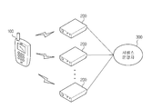
도 1은 본 발명의 일 실시예에 의한 위치 기반 정보를 이용한 증강 현실 서비스 시스템의 전체 구성도이다.
도 2는 본 발명의 일 실시예에 의한 위치 기반 정보를 이용한 증강 현실 서비스 시스템의 제어 블록도이다.
도 3은 본 발명의 일 실시예에 의한 위치 기반 정보를 이용한 증강 현실 서비스 시스템에서 특징점 추출을 위한 이미지 패치의 개념도이다.
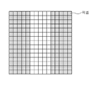
도 4는 본 발명의 일 실시예에 의한 위치 기반 정보를 이용한 증강 현실 서비스 시스템에 적용되는 복수의 기지국에 할당된 기본 단위 셀을 나타낸 도면이다.
도 5는 본 발명의 일 실시예에 의한 위치 기반 정보를 이용한 증강 현실 서비스 장치에서 영상 내 분포된 특징점을 나타낸 도면이다.
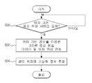
도 6은 본 발명의 일 실시예에 의한 위치 기반 정보를 이용한 증강 현실 서비스 방법에서 위치 인식 과정을 나타낸 동작 순서도이다.
도 7은 본 발명의 일 실시예에 의한 위치 기반 정보를 이용한 증강 현실 서비스 방법에서 증강 현실을 구현하는 과정을 나타낸 동작 순서도이다.1 is an overall configuration diagram of an augmented reality service system using location-based information according to an embodiment of the present invention.
2 is a control block diagram of an augmented reality service system using location based information according to an embodiment of the present invention.
3 is a conceptual diagram of an image patch for feature point extraction in an augmented reality service system using location based information according to an embodiment of the present invention.
4 is a diagram illustrating basic unit cells allocated to a plurality of base stations applied to an augmented reality service system using location based information according to an embodiment of the present invention.
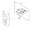
FIG. 5 is a diagram illustrating distributed feature points in an image in an augmented reality service device using location based information according to an embodiment of the present invention.
6 is a flowchart illustrating a location recognition process in an augmented reality service method using location based information according to an embodiment of the present invention.
7 is a flowchart illustrating a process of implementing augmented reality in the augmented reality service method using location-based information according to an embodiment of the present invention.
이하, 본 발명의 일 실시예를 첨부된 도면을 참조하여 상세히 설명한다.Hereinafter, an embodiment of the present invention will be described in detail with reference to the accompanying drawings.
도 1은 본 발명의 일 실시예에 의한 위치 기반 정보를 이용한 증강 현실 서비스 시스템의 전체 구성도이다.1 is an overall configuration diagram of an augmented reality service system using location-based information according to an embodiment of the present invention.
도 1에서, 본 발명의 일 실시예에 의한 위치 기반 정보를 이용한 증강 현실 서비스 시스템은 위치 기반 정보를 이용하여 증강 현실(AR) 서비스를 구현하는 사용자 단말기(100)와, 증강 현실(AR) 서비스를 구현하기 위한 위치 기반 정보를 사용자 단말기(100)에 제공하는 복수의 기지국(200)과, 사용자 단말기(100)가 위치하게 되는 영역의 특징점을 미리 추출하여 복수의 기지국(200)에 각각 등록시키는 서비스 운영자(300)를 포함한다. 사용자 단말기(100)와 복수의 기지국(200)은 IP 망, 인터넷 망, 이동 통신망, 랜(LAN) 등과 같은 네트워크를 통해 연결되어 상호간 통신을 수행하도록 되어 있다.In FIG. 1, an augmented reality service system using location based information according to an embodiment of the present invention includes a
도 2는 본 발명의 일 실시예에 의한 위치 기반 정보를 이용한 증강 현실 서비스 시스템의 제어 블록도이다.2 is a control block diagram of an augmented reality service system using location based information according to an embodiment of the present invention.
도 2에서, 사용자 단말기(100)는 위치 기반 서비스를 통해 제공되는 지역 정보에 실제 카메라 영상을 결합하여 증강 현실 서비스를 구현하는 장치로, 통신부(110), 영상 획득부(120), 입력부(130), 제어부(140), 디스플레이부(150)를 포함한다. 사용자 단말기(100)는 스마트 폰, PDA(Personal Digital Assistance) 등과 같은 이동 단말기를 사용한다.In FIG. 2, the
통신부(110)는 제어부(140)의 제어에 따라 IP 망, 인터넷 망, 이동 통신망, 랜(LAN) 등과 같은 네트워크를 통해 복수의 기지국(200)과 통신한다.The
영상 획득부(120)는 사용자가 실제 보고 있는 환경의 영상을 촬영하여 실제 영상의 현재 이미지를 획득하는 카메라이다.The
입력부(130)는 사용자가 원하는 옵션(예를 들어, 위치 기반의 증강 현실 서비스 요청)을 설정한다.The
제어부(140)는 입력부를 통해 설정된 위치 기반의 증강 현실(AR) 서비스 요청에 따라 복수의 기지국(200)으로 위치 기반 정보를 요청하고, 복수의 기지국(200)으로부터 각 기지국(200)의 위치 기반 정보를 전송받아 영상 획득부(120)를 통해 획득된 실제 영상에 전송된 위치 기반 정보(가상의 영상)를 결합하여 증강 현실(AR) 형태의 서비스를 구현한다.The
이를 위해 제어부(140)는, 통신부(110)를 통해 연결 가능한 기지국(200) 및 AP(Access Point)를 탐색하고, 탐색된 모든 기지국(200)에 위치 정보의 전송을 요청한다. 탐색된 모든 기지국(200)으로부터 위치 정보가 전송되면 각 기지국(200)의 위치 정보와 전송 시간(정보 도달 시간)으로부터 사용자 단말기(100)의 위치를 확인한다. To this end, the
또한, 제어부(140)는 확인된 사용자 단말기(100)의 위치로부터 셀 위치를 추산하여 현재 사용자 단말기(100)의 위치가 어느 셀에 속해 있는지 판단하고, 판단된 셀에 해당하는 기지국(200)에 셀 넘버와 특징점에 해당하는 이미지 패치 데이터의 전송을 요청한다. 해당 기지국(200)으로부터 셀에 해당하는 이미지 패치 특징점들이 전송되면 전송받은 특징점들을 영상 획득부(120)를 통해 획득된 현재 이미지와 일대일 대응시키는 매칭 작업을 수행한다. 특징점이 매칭되면 칼만 필터를 통해 특징점을 추적하여 카메라의 현재 위치와 자세 정보를 획득한다(Localization).In addition, the
카메라의 현재 위치와 자세 정보가 획득되면, 제어부(140)는 디스플레이부(150)에 가상의 정보를 카메라 위치 정보에 결합한 영상을 표시하여 3차원 증강 현실(AR) 형태의 가상화 정보를 투영하는 서비스를 구현하게 된다.When the current position and posture information of the camera is obtained, the
디스플레이부(150)는 제어부(140)의 제어에 따라 영상 획득부(120)를 통해 획득된 실제 영상과 이에 동일한 방향으로 배열시킨 위치 기반 정보를 제공하여 단말기 화면을 통해 사용자에게 표시한다. 즉, 디스플레이부(150)는 사용자에게 실제 영상과 위치 기반 정보가 결합된 증강 현실(AR) 형태의 서비스를 제공한다.Under the control of the
복수의 기지국(200)은 통화 및 정보 전송을 위하여 사용자 단말기(100)와 항상 통신을 수행할 수 있도록 되어 있으며, 사용자 단말기(100)가 위치하게 되는 영역 즉, 자신에게 분할된 영역의 데이터를 관리한다. The plurality of
복수의 기지국(200)은 자신의 위치 정보를 저장하는 위치 정보 DB(201)와, 사용자 단말기(100)와 통신이 가능한 영역 즉, 해당 기지국(200)에서 관리하는 영역의 이미지 패치 특징점 정보들을 저장하는 특징점 정보 DB(202)와, 사용자 단말기(100)와 통신이 가능한 영역 즉, 해당 기지국(200)에서 관리하는 영역의 위치 기반 지역 정보들을 저장하는 위치 기반 지역 정보 DB(203)를 각각 포함한다.The plurality of
서비스 운영자(300)는 사용자 단말기(100)가 위치하게 되는 지역의 이미지 패치 데이터(특징점)들을 미리 추출하여 복수의 기지국(200)에 등록한다. 서비스 운영자(300)는 복수의 기지국(200)마다 할당된 셀에 대한 특징점 정보를 카메라를 통해 획득된 영상에서 추출해내는 것이다. 통상적으로, SLAM(Simultaneous Localization And Mapping)은 자기의 위치를 찾는 위치 인식(Localization) 과정과 이미지를 등록하는 지도 작성(Mapping) 과정으로 구성되는데, 특징점들을 미리 추출하여 지도를 작성하는(Mapping) 과정을 서비스 운영자(300)가 기지국(200)에 미리 등록시켜 놓음으로써 사용자 단말기(100)는 자기의 위치를 찾는 위치 인식(Localization) 과정만을 수행하는 monocular SLAM 기술을 사용하게 된다.The
특징점은 획득된 영상에서 일정한 점을 선택하였을 때 시간과 관찰 각도에 의해서 변하지 않는 정량적 특징을 추출할 수 있어야 한다. 보통 영상에서는 코너(Corner) 이미지 또는 이미지 패치를 사용하여 어느 각도에서 관찰하여도 변하지 않는 특징점을 찾아낸다.The feature point should be able to extract quantitative features that do not change with time and observation angle when a certain point is selected from the acquired image. In normal images, corner images or image patches are used to find feature points that do not change when viewed from any angle.
도 3은 본 발명의 일 실시예에 의한 위치 기반 정보를 이용한 증강 현실 서비스 시스템에서 특징점 추출을 위한 이미지 패치의 개념도이다.3 is a conceptual diagram of an image patch for feature point extraction in an augmented reality service system using location based information according to an embodiment of the present invention.
도 3에서, 특징점은 15픽셀(pixel) × 15픽셀(pixel) 정도 또는 이보다 큰 이미지 패치로 구성되며, 특징점은 영상 중에서 연산자(salience operator)를 통하여 고유값이 높은 데이터를 추출한다. 이 방법은 이미지 패치상에서 에지 특성이 높은 데이터를 추출하는 것으로 다른 영상에 비하여 구분이 쉬운 특성을 가진다.In FIG. 3, the feature point is composed of an image patch of about 15 pixels by 15 pixels or larger, and the feature point extracts data having a high eigenvalue from an image through an operator. This method extracts data with high edge characteristics from the image patch and has a characteristic that is easier to distinguish than other images.
도 4는 본 발명의 일 실시예에 의한 위치 기반 정보를 이용한 증강 현실 서비스 시스템에 적용되는 복수의 기지국에 할당된 기본 단위 셀을 나타낸 도면이다.4 is a diagram illustrating basic unit cells allocated to a plurality of base stations applied to an augmented reality service system using location based information according to an embodiment of the present invention.
도 4에서, 복수의 기지국(200)은 사용자 단말기(100)가 위치하게 되는 지역을 20m × 20m 단위의 셀 형태로 영역을 분할하여 데이터를 관리한다. 분할된 영역은 정사각형의 변을 기준으로 5m 정도 겹치도록 분할하며, 사용자 단말기(100)는 기본 단위 셀을 기준으로 복수의 기지국(200)에 자신의 위치를 전달한다.In FIG. 4, the plurality of
또한, 복수의 기지국(200)은 자신에게 할당된 셀에 대한 특징점 정보를 가지는데, 보통 한 셀당 500~1000개의 특징점 정보를 가지고 있다. 특징점 정보는 이미지 패치에 대한 픽셀(pixel) 정보와 3차원 데이터 정보이다. 3차원 데이터 정보는 도 4에 도시한 셀의 남서쪽 모서리를 (0,0,0)으로 한 로컬 좌표계를 사용하여 Monocular Localization을 수행한다. 사용자 단말기(100)는 각각의 기지국(200)으로부터 획득한 기지국(200) 위치 정보와 전송 시간(정보 도달 시간) 또는 기지국(200) ID정보를 사용하여 사용자 단말기(100)의 위치가 어느 셀에 속해 있는지를 파악하게 된다. 사용자 단말기(100)로부터 현재 위치의 셀에 해당하는 정보를 요청받게 되면 해당 셀의 특징점 정보를 사용자 단말기(100)에 전송한다. 사용자가 이동하여 셀과 셀이 겹치는 공통 지역(즉, 정사각형의 변을 기준으로 5m 정도 겹치는 지역)에 들어가게 되면 사용자 단말기(100)는 이동된 곳의 특징점 정보를 연결하여 전송받고 공통된 특징점 정보를 모두 이용하게 된다. 이렇게 사용자가 단말기(100)가 위치한 영역의 특징점 정보(고유의 이미지 패치)를 사용자 단말기(100) 내에서 관리하게 되면 방대한 지도 영역을 생각하지 않더라도 관할 영역의 데이터만을 사용자 단말기(100)에 전송할 수 있으므로 빠르게 영역 정보를 전달할 수 있다. 또한 영상을 통하여 현재 위치와 자세를 추정함에 있어서 영상에서 새롭게 뽑아 낸 특징점 정보들과 데이터베이스 상의 특징점을 일대일 대응시킬 때에도 한정된 개수에서 비교하면 되므로 매우 빠른 속도로 SLAM 알고리즘을 수행할 수 있게 된다.In addition, the
도 5는 본 발명의 일 실시예에 의한 위치 기반 정보를 이용한 증강 현실 서비스 장치에서 영상 내 분포된 특징점을 나타낸 도면이다.FIG. 5 is a diagram illustrating distributed feature points in an image in an augmented reality service device using location based information according to an embodiment of the present invention.
도 5에서, 사용자 단말기(100)의 영상 획득부(120)에서 사용자가 실제 보고 있는 환경의 영상을 촬영하여 현재 이미지를 획득하면, 사용자 단말기(100)가 위치한 영역을 관리하는 해당 기지국(200)에서 획득된 현재 이미지의 영상 내 분포하는 특징점(ㅁ)들을 사용자 단말기(100)에게 전송한다.In FIG. 5, when the
이는 방대한 위치 정보를 사용자 단말기(100)에 모두 저장할 수도 없으며, 또한 방대한 데이터 속에서 자기 위치를 찾는 것은 데이터 검색 시간이 너무 많이 소요되는 문제가 있다. 따라서 분할을 통하여 지역적으로 구획하여 약 20 x 20m 단위의 셀 형태로 데이터를 관리하는 것이 Monocular SLAM에서는 가장 효율적인 방법이라고 볼 수 있다. 일단 사용자 단말기(100)의 위치를 기지국(200)을 통하여 셀 단위로 얻고, 사용자 단말기(100)가 위치한 영역에서 기지국(200)에 등록된 특징점을 전송받아 Monocular Localization을 수행한다.This is because it is not possible to store all of the vast location information in the
한편, 관할 영역이 큰 기지국(200)의 경우에는 위치 정밀도의 정확성을 20m X 20m 단위로 결정하기가 어렵게 된다. 따라서 근처의 기지국(200) 3~4개로부터 전송되는 데이터가 걸리는 시간을 전송받음으로써 3개 이상의 기지국(200)에서 전송된 신호의 도착시간으로 위치를 계산하는 time of arrival 방식을 통해 20 x 20m의 위치 정밀도를 획득할 수 있도록 한다.On the other hand, in the case of the
또한, 관할 영역이 작은 기지국(200)의 경우에는 사실상 wi-fi AP가 많이 보급되어 어느 곳에서도 무선망 사용이 가능하여 무선 AP를 감지할 수 있다면 위치 정확도는 20m 반경까지 정확도를 증가시킬 수 있을 것이다. 이 경우에는 복잡한 방법을 배제하고 셀ID만으로 20m X 20m 위치 정밀도를 획득할 수 있도록 한다.In addition, in the case of the
이하, 상기와 같이 구성된 위치 기반 정보를 이용한 증강 현실 서비스 장치 및 그 방법의 동작과정 및 작용효과를 설명한다.Hereinafter, an operation process and an effect of the augmented reality service device and the method using the location-based information configured as described above will be described.
도 6은 본 발명의 일 실시예에 의한 위치 기반 정보를 이용한 증강 현실 서비스 방법에서 위치 인식 과정을 나타낸 동작 순서도이다.6 is a flowchart illustrating a location recognition process in an augmented reality service method using location based information according to an embodiment of the present invention.
도 6에서, 사용자 단말기(100)의 제어부(140)는 통신부(110)를 통해 연결 가능한 기지국(200) 및 AP(Access Point)를 탐색하고(500), 탐색된 모든 기지국(200)에 위치 정보의 전송을 요청한다(502). In FIG. 6, the
사용자 단말기(100)의 위치 정보 전송 요청에 따라, 위치 정보의 전송을 요청받은 모든 기지국(200)에서 해당 기지국(200)의 위치 정보를 사용자 단말기(100)에 전송한다.In response to a request for transmitting location information of the
탐색된 모든 기지국(200)으로부터 위치 정보가 전송되면(504), 제어부(140)는 각 기지국(200)의 위치 정보와 전송 시간(정보 도달 시간)으로부터 사용자 단말기(100)의 위치를 확인한다(506).When the location information is transmitted from all of the discovered base stations 200 (504), the
이후, 제어부(140)는 확인된 사용자 단말기(100)의 위치로부터 셀 위치를 추산하여 현재 사용자 단말기(100)의 위치가 어느 셀에 속해 있는지 판단하고(508), 판단된 셀에 해당하는 기지국(200)에 셀 넘버와 특징점에 해당하는 이미지 패치 데이터의 전송을 요청한다(510).Subsequently, the
사용자 단말기(100)의 특징점 정보 전송 요청에 따라, 특징점 정보의 전송을 요청받은 해당 기지국(200)은 자신에게 할당되어 저장하고 있는 셀에 대한 이미지 패치 특징점들을 사용자 단말기(100)에 전송한다.In response to the request for transmitting the feature point information of the
해당 기지국(200)으로부터 특징점 정보가 전송되면(512), 제어부(140)는 영상 획득부(120)를 통해 획득된 현재 이미지와 특징점의 데이터베이스와 일대일 대응을 시켜야 한다. 특징점의 픽셀이 화면상의 어떤 픽셀인지 알 수가 없기 때문에 연산자(operator)를 통하여 비슷한 고유값을 가진 특징점을 매칭한다. 이중 유사한 고유값을 가지는 특징점끼리 매칭 시키고 몇 개의 특징점이 매칭되면 기하학적인 관계를 이용하여 특징점간의 관계를 일치시킨다.When the feature point information is transmitted from the base station 200 (512), the
일단 특징점이 매칭되면(516), 칼만 필터를 통하여 특징점을 추적하여(518) 카메라의 현재 위치와 자세 정보를 획득하는 갱신을 수행한다(520), 초기 매칭이 진행된 후에는 자체 카메라 운동 모델을 통해 예측 과정과 갱신 과정을 반복하여 사용자 단말기(100) 자세 보정을 수행하므로 많은 시간을 필요로 하지 않으며 안정적으로 추정을 수행할 수 있다. 매칭이 끝난 후의 특징점 추적은 확장 칼만 필터를 통하여 진행된다.Once the feature points are matched (516), the feature points are tracked through the Kalman filter (518) and the update is performed to obtain the current position and pose information of the camera (520). Since the posture correction is performed by repeating the prediction process and the update process, the
도 6의 위치 인식 과정을 통하여 카메라의 현재 위치와 자세를 획득하면, 디스플레이부(150) 영상에 가상의 정보를 위치 정보에 덧붙여 표시할 수 있다. 예를 들어 카메라를 통해 얻은 영상과 이에 동일한 방향으로 배열시킨 정보를 제공함으로써 증강 현실(AR) 형태의 서비스를 보다 시각적으로 구현할 수 있다. 예를 들면 목적지 검색을 하면 방향을 바닥에 화살표를 투영함으로서 방향을 직접 제시하여 주기도 한다. 또한 마트와 대형상점에서 원하는 물건이 어디 있는지를 확인할 경우 위치에 대한 정보를 그 자리에서 제공해 줄 수도 있다.When the current position and posture of the camera are obtained through the position recognition process of FIG. 6, virtual information may be displayed on the image of the display unit 150 in addition to the position information. For example, by providing an image obtained through a camera and information arranged in the same direction, augmented reality (AR) type of service may be more visually realized. For example, when searching for a destination, the direction may be directly presented by projecting the arrow on the floor. You can also provide information about the location on the spot if you want to know where the goods you want are located in supermarkets and large stores.
도 7은 본 발명의 일 실시예에 의한 위치 기반 정보를 이용한 증강 현실 서비스 방법에서 증강 현실을 구현하는 과정을 나타낸 동작 순서도이다.7 is a flowchart illustrating a process of implementing augmented reality in the augmented reality service method using location-based information according to an embodiment of the present invention.
도 7에서, 사용자는 입력부(130)를 통해 원하는 옵션 즉, 위치 기반의 증강 현실(AR) 서비스 요청을 설정한다(600).In FIG. 7, the user sets a desired option, that is, a location-based augmented reality (AR) service request, through the input unit 130 (600).
따라서, 제어부(140)는 입력부(130)를 통해 설정된 위치 기반의 증강 현실(AR) 서비스 요청에 따라 복수의 기지국(200)으로 위치 기반 정보를 요청한다.Therefore, the
사용자 단말기(100)의 위치 기반 정보 전송 요청에 따라, 위치 기반 정보의 전송을 요청받은 해당 기지국(200)은 저장하고 있는 위치 기반 정보(지역 정보)를 위한 3차원 가상 물체 또는 정보 물체 등의 증강 현실(AR) 데이터와 정보가 위치할 좌표(배치 위치)를 동시에 사용자 단말기(100)에 전송한다.In response to the location-based information transmission request of the
해당 기지국(200)으로부터 위치 기반 정보(지역 정보)를 위한 3차원 증강 현실(AR) 데이터 및 배치 위치가 전송되면(602), 제어부(140)는 영상 획득부(120)를 통해 획득된 실제 영상에 전송된 위치 기반 정보(가상의 영상)를 결합하여 배치 위치에 가상화 정보를 투영시킴으로써 증강 현실(AR) 형태의 서비스를 구현한다(604).When the 3D augmented reality (AR) data for the location-based information (area information) and the arrangement position are transmitted from the corresponding base station 200 (602), the
한편, 일정한 장소에서도 조금씩 환경의 변화가 있을 수 있으므로 등록된 특징점이 매우 많은 가능성을 가지고 수렴하지 않을 경우, 이 특징점을 수정 대상으로 선정할 수 있다. 등록된 특징점의 일치율이 현저하게 낮을 경우 사용자 단말기(100) 측에서 기지국(200)으로 오류 특징점으로 후보군을 만들고, 오류 신호가 일정 수준을 초과하게 되면 특징점을 폐기하고 새로운 특징점을 찾아 등록할 수 있도록 한다.On the other hand, there may be a slight change in the environment even in a certain place, so if the registered feature points do not converge with a great possibility, this feature point may be selected as a correction target. If the matching rate of the registered feature points is significantly low, the candidate terminal is created as an error feature point from the
본 발명의 일 실시예를 통하여 기지국(200) 기반 Localization과 Monocular SLAM로 위치 기반 정보를 이용한 증강 현실(AR) 서비스를 구현할 수 있게 됨으로써 다양한 위치 기반 서비스(Localization Based Service)를 제공할 수 있고, 이로 인하여 새로운 형태의 서비스를 제공할 수 있을 것으로 사료된다. 구글이나 다음의 예를 보면 지도 형태의 위치 기반 서비스를 제공함으로써 엄청난 이익을 창출할 수 있었던 사례를 볼 수 있었는데 본 발명은 이러한 증강 현실(AR) 서비스를 실시간으로 이동하면서 구현할 수 있게 하며 현재 사용자가 보고 있는 화면에 직접 위치 기반 정보(지역 정보)를 제공할 수 있으므로 비교할 수 없을 정도의 효과를 창출할 수 있을 것으로 보인다.Through an embodiment of the present invention, it is possible to implement an augmented reality (AR) service using location-based information with a
100 : 사용자 단말기 110 : 통신부
120 : 영상 획득부 130 : 입력부
140 : 제어부 150 : 디스플레이부
200 : 기지국 300 : 서비스 운영자100: user terminal 110: communication unit
120: image acquisition unit 130: input unit
140: control unit 150: display unit
200: base station 300: service operator
Claims (12)
실제 영상을 획득하는 카메라;
상기 복수의 기지국 중 적어도 하나의 기지국으로부터 상기 영상의 특징점 정보를 전송받아 상기 특징점의 데이터와 상기 카메라의 영상 데이터를 매칭하여 상기 카메라의 위치를 획득하고, 상기 카메라의 위치에 따라 상기 실제 영상과 동일한 방향으로 상기 위치 기반 정보를 제공하는 제어부;
상기 제어부의 제어에 따라 상기 실제 영상과 상기 위치 기반 정보가 결합된 증강 현실 서비스를 구현하는 디스플레이부를 포함하는 위치 기반 정보를 이용한 증강 현실 서비스 장치.An apparatus for implementing augmented reality service using location-based information in a user terminal communicating with a plurality of base stations,
A camera for acquiring an actual image;
Receives feature point information of the image from at least one base station among the plurality of base stations, acquires the position of the camera by matching the data of the feature point and the image data of the camera, and obtains the same position as the actual image according to the position of the camera. A controller for providing the location-based information in a direction;
An augmented reality service apparatus using location based information including a display unit for implementing an augmented reality service in which the real image and the location based information are combined under the control of the controller.
상기 복수의 기지국은 상기 사용자 단말기가 위치하는 영역을 셀 단위로 구획하여 해당 셀에 대한 특징점 정보와 위치 기반 정보를 관리하는 위치 기반 정보를 이용한 증강 현실 서비스 장치.The method of claim 1,
And a plurality of base stations divides an area in which the user terminal is located in units of cells and manages feature point information and location based information on a corresponding cell.
상기 복수의 기지국과 통신하는 통신부를 더 포함하고,
상기 제어부는 상기 복수의 기지국 중 상기 통신부를 통해 연결 가능한 기지국을 탐색하고, 상기 탐색된 모든 기지국의 위치 정보를 전송받아 상기 사용자 단말기의 위치를 확인하는 위치 기반 정보를 이용한 증강 현실 서비스 장치.The method of claim 1,
Further comprising a communication unit for communicating with the plurality of base stations,
The controller searches for a base station connectable through the communication unit among the plurality of base stations, and receives location information of all the discovered base stations to determine the location of the user terminal using augmented reality service device.
상기 제어부는 상기 확인된 사용자 단말기의 위치에 따라 해당 기지국에 상기 특징점에 해당하는 이미지 패치 데이터의 전송을 요청하는 위치 기반 정보를 이용한 증강 현실 서비스 장치.The method of claim 3,
The control unit is augmented reality service apparatus using the location-based information for requesting the base station to transmit the image patch data corresponding to the feature point in accordance with the identified location of the user terminal.
상기 제어부는 상기 해당 기지국으로부터 상기 특징점에 해당하는 이미지 패치 데이터를 전송받아 상기 카메라를 통해 획득된 현재 이미지와 일대일 대응시키는 매칭 작업을 수행하는 위치 기반 정보를 이용한 증강 현실 서비스 장치.The method of claim 4, wherein
The control unit is augmented reality service apparatus using the location-based information that receives the image patch data corresponding to the feature point from the base station to perform a matching operation to one-to-one correspond to the current image obtained through the camera.
상기 제어부는 상기 특징점이 매칭되면 상기 특징점을 추적하여 상기 카메라의 현재 위치와 자세 정보를 획득하는 위치 기반 정보를 이용한 증강 현실 서비스 장치.The method of claim 5,
The controller is augmented reality service apparatus using the location-based information to obtain the current position and attitude information of the camera by tracking the feature point if the feature point is matched.
카메라를 통해 실제 영상을 획득하고;
상기 복수의 기지국 중 연결 가능한 기지국을 탐색하여 상기 사용자 단말기의 위치를 확인하고;
상기 사용자 단말기의 위치에 따라 해당 기지국에 상기 영상의 특징점 데이터를 요청하고;
상기 해당 기지국으로부터 상기 특징점 데이터를 전송받아 상기 특징점 데이터와 상기 카메라의 영상 데이터를 매칭하여 상기 카메라의 위치를 획득하고;
상기 카메라의 위치에 따라 상기 실제 영상과 동일한 방향으로 상기 위치 기반 정보를 결합하여 증강 현실 서비스를 구현하는 위치 기반 정보를 이용한 증강 현실 서비스 방법.A method of implementing augmented reality service using location-based information in a user terminal communicating with a plurality of base stations,
Acquire a real image through a camera;
Searching for connectable base stations among the plurality of base stations to determine the location of the user terminal;
Requesting feature point data of the video from a corresponding base station according to the location of the user terminal;
Receiving the feature point data from the corresponding base station and matching the feature point data with the image data of the camera to obtain a position of the camera;
Augmented reality service method using location-based information to implement the augmented reality service by combining the location-based information in the same direction as the actual image according to the position of the camera.
상기 복수의 기지국은 상기 사용자 단말기가 위치하는 영역을 셀 단위로 구획하여 해당 셀에 대한 특징점 정보와 위치 기반 정보를 관리하는 위치 기반 정보를 이용한 증강 현실 서비스 방법.The method of claim 7, wherein
And a plurality of base stations divides an area in which the user terminal is located in units of cells and manages feature point information and location based information on a corresponding cell.
상기 사용자 단말기의 위치를 확인하는 것은,
상기 탐색된 모든 기지국에 위치 정보를 요청하고, 상기 탐색된 모든 기지국으로부터 위치 정보가 전송되면 상기 위치 정보와 전송 시간을 이용하여 상기 사용자 단말기의 위치를 확인하는 위치 기반 정보를 이용한 증강 현실 서비스 방법.The method of claim 8,
Checking the location of the user terminal,
Requesting location information from all of the discovered base stations, and when location information is transmitted from all of the discovered base stations, using the location-based information to determine the location of the user terminal using the location information and the transmission time.
상기 영상의 특징점 데이터를 요청하는 것은,
상기 사용자 단말기의 위치가 상기 복수의 기지국에 할당된 어느 셀에 속하는지를 판단하여 해당 기지국에 상기 영상의 특징점 데이터를 요청하는 위치 기반 정보를 이용한 증강 현실 서비스 방법.10. The method of claim 9,
Requesting the feature point data of the image,
The method of claim 1, wherein the location of the user terminal belongs to a cell assigned to the plurality of base stations and requests the base station to request feature point data of the image.
상기 카메라의 위치를 획득하는 것은,
상기 해당 기지국으로부터 상기 특징점에 해당하는 이미지 패치 데이터를 전송받아 상기 카메라를 통해 획득된 현재 이미지와 일대일 대응시키는 매칭 작업을 통해 상기 카메라의 현재 위치와 자세 정보를 획득하는 위치 기반 정보를 이용한 증강 현실 서비스 방법.The method of claim 10,
Acquiring the position of the camera,
Augmented reality service using the location-based information to obtain the current position and posture information of the camera through a matching operation of receiving image patch data corresponding to the feature point from the corresponding base station and one-to-one correspondence with the current image obtained through the camera Way.
상기 증강 현실 서비스를 구현하는 것은,
상기 카메라에서 획득한 실제 영상에 상기 해당 기지국으로부터 전송되는 위치 기반 정보를 결합하여 3차원의 증강 현실 서비스를 구현하는 위치 기반 정보를 이용한 증강 현실 서비스 방법.The method of claim 7, wherein
Implementing the augmented reality service,
Augmented reality service method using location-based information to implement a three-dimensional augmented reality service by combining the location-based information transmitted from the base station with the real image obtained by the camera.
Priority Applications (2)
| Application Number | Priority Date | Filing Date | Title |
|---|---|---|---|
| KR1020100000273A KR101667033B1 (en) | 2010-01-04 | 2010-01-04 | Augmented reality service apparatus using location based data and method the same |
| US12/977,536 US8644859B2 (en) | 2010-01-04 | 2010-12-23 | Apparatus to provide augmented reality service using location-based information and computer-readable medium and method of the same |
Applications Claiming Priority (1)
| Application Number | Priority Date | Filing Date | Title |
|---|---|---|---|
| KR1020100000273A KR101667033B1 (en) | 2010-01-04 | 2010-01-04 | Augmented reality service apparatus using location based data and method the same |
Publications (2)
| Publication Number | Publication Date |
|---|---|
| KR20110080098A true KR20110080098A (en) | 2011-07-12 |
| KR101667033B1 KR101667033B1 (en) | 2016-10-17 |
Family
ID=44224985
Family Applications (1)
| Application Number | Title | Priority Date | Filing Date |
|---|---|---|---|
| KR1020100000273A KR101667033B1 (en) | 2010-01-04 | 2010-01-04 | Augmented reality service apparatus using location based data and method the same |
Country Status (2)
| Country | Link |
|---|---|
| US (1) | US8644859B2 (en) |
| KR (1) | KR101667033B1 (en) |
Cited By (3)
| Publication number | Priority date | Publication date | Assignee | Title |
|---|---|---|---|---|
| KR20150058617A (en) * | 2013-11-18 | 2015-05-29 | 순천대학교 산학협력단 | System and Method for 3-Dimensional Model Visualization of Drawing based Mobile Augmented Reality |
| KR20190063877A (en) * | 2017-11-30 | 2019-06-10 | 주식회사 한화 | Apparatus and method for managing training simulation forward observation |
| KR20210121488A (en) | 2020-03-30 | 2021-10-08 | 한국전자통신연구원 | Apparatus and method for providing mixed reality service |
Families Citing this family (22)
| Publication number | Priority date | Publication date | Assignee | Title |
|---|---|---|---|---|
| KR101357262B1 (en) | 2010-08-13 | 2014-01-29 | 주식회사 팬택 | Apparatus and Method for Recognizing Object using filter information |
| US8649803B1 (en) | 2011-05-03 | 2014-02-11 | Kristan Lisa Hamill | Interactive tracking virtual world system |
| EP2750110B1 (en) * | 2011-08-24 | 2020-03-18 | Sony Corporation | Information processing device, information processing method, and program |
| US8838147B2 (en) * | 2011-08-31 | 2014-09-16 | Nokia Corporation | Method and apparatus for determining environmental context utilizing features obtained by multiple radio receivers |
| US8521128B1 (en) | 2011-12-09 | 2013-08-27 | Google Inc. | Method, system, and computer program product for obtaining crowd-sourced location information |
| US9277367B2 (en) * | 2012-02-28 | 2016-03-01 | Blackberry Limited | Method and device for providing augmented reality output |
| GB2506338A (en) | 2012-07-30 | 2014-04-02 | Sony Comp Entertainment Europe | A method of localisation and mapping |
| US9270885B2 (en) | 2012-10-26 | 2016-02-23 | Google Inc. | Method, system, and computer program product for gamifying the process of obtaining panoramic images |
| US9325861B1 (en) | 2012-10-26 | 2016-04-26 | Google Inc. | Method, system, and computer program product for providing a target user interface for capturing panoramic images |
| US9088625B1 (en) | 2012-12-12 | 2015-07-21 | Google Inc. | Obtaining an image for a place of interest |
| US9779517B2 (en) | 2013-03-15 | 2017-10-03 | Upskill, Inc. | Method and system for representing and interacting with augmented reality content |
| US20140301645A1 (en) * | 2013-04-03 | 2014-10-09 | Nokia Corporation | Method and apparatus for mapping a point of interest based on user-captured images |
| US9881023B2 (en) | 2014-07-22 | 2018-01-30 | Microsoft Technology Licensing, Llc | Retrieving/storing images associated with events |
| US20180013842A1 (en) * | 2016-07-05 | 2018-01-11 | Leanor Oy | Method and system for providing user with information related to premises |
| CN106210450B (en) * | 2016-07-20 | 2019-01-11 | 罗轶 | A kind of multichannel multi-angle of view big data video clipping method |
| CN107024980A (en) * | 2016-10-26 | 2017-08-08 | 阿里巴巴集团控股有限公司 | Customer location localization method and device based on augmented reality |
| KR102014706B1 (en) * | 2017-02-15 | 2019-08-27 | 한양대학교 산학협력단 | Method for saving and loading of slam map |
| CN107219920A (en) * | 2017-05-15 | 2017-09-29 | 北京小米移动软件有限公司 | The recognition methods of AR glasses, device and AR glasses based on scene |
| KR102299847B1 (en) * | 2017-06-26 | 2021-09-08 | 삼성전자주식회사 | Face verifying method and apparatus |
| US10964112B2 (en) * | 2018-10-12 | 2021-03-30 | Mapbox, Inc. | Candidate geometry displays for augmented reality |
| US10902685B2 (en) | 2018-12-13 | 2021-01-26 | John T. Daly | Augmented reality remote authoring and social media platform and system |
| EP4135352A1 (en) * | 2021-08-11 | 2023-02-15 | Nokia Technologies Oy | Localizing a camera-equipped device using a captured visual image |
Citations (3)
| Publication number | Priority date | Publication date | Assignee | Title |
|---|---|---|---|---|
| KR20050078136A (en) * | 2004-01-30 | 2005-08-04 | 삼성전자주식회사 | Method for providing local information by augmented reality and local information service system therefor |
| US20080268876A1 (en) * | 2007-04-24 | 2008-10-30 | Natasha Gelfand | Method, Device, Mobile Terminal, and Computer Program Product for a Point of Interest Based Scheme for Improving Mobile Visual Searching Functionalities |
| US7630737B2 (en) * | 2001-10-09 | 2009-12-08 | Sirf Technology, Inc. | Method and system for sending location coded images |
Family Cites Families (2)
| Publication number | Priority date | Publication date | Assignee | Title |
|---|---|---|---|---|
| US7796155B1 (en) * | 2003-12-19 | 2010-09-14 | Hrl Laboratories, Llc | Method and apparatus for real-time group interactive augmented-reality area monitoring, suitable for enhancing the enjoyment of entertainment events |
| US8427508B2 (en) * | 2009-06-25 | 2013-04-23 | Nokia Corporation | Method and apparatus for an augmented reality user interface |
-
2010
- 2010-01-04 KR KR1020100000273A patent/KR101667033B1/en active IP Right Grant
- 2010-12-23 US US12/977,536 patent/US8644859B2/en active Active
Patent Citations (3)
| Publication number | Priority date | Publication date | Assignee | Title |
|---|---|---|---|---|
| US7630737B2 (en) * | 2001-10-09 | 2009-12-08 | Sirf Technology, Inc. | Method and system for sending location coded images |
| KR20050078136A (en) * | 2004-01-30 | 2005-08-04 | 삼성전자주식회사 | Method for providing local information by augmented reality and local information service system therefor |
| US20080268876A1 (en) * | 2007-04-24 | 2008-10-30 | Natasha Gelfand | Method, Device, Mobile Terminal, and Computer Program Product for a Point of Interest Based Scheme for Improving Mobile Visual Searching Functionalities |
Cited By (3)
| Publication number | Priority date | Publication date | Assignee | Title |
|---|---|---|---|---|
| KR20150058617A (en) * | 2013-11-18 | 2015-05-29 | 순천대학교 산학협력단 | System and Method for 3-Dimensional Model Visualization of Drawing based Mobile Augmented Reality |
| KR20190063877A (en) * | 2017-11-30 | 2019-06-10 | 주식회사 한화 | Apparatus and method for managing training simulation forward observation |
| KR20210121488A (en) | 2020-03-30 | 2021-10-08 | 한국전자통신연구원 | Apparatus and method for providing mixed reality service |
Also Published As
| Publication number | Publication date |
|---|---|
| KR101667033B1 (en) | 2016-10-17 |
| US20110165893A1 (en) | 2011-07-07 |
| US8644859B2 (en) | 2014-02-04 |
Similar Documents
| Publication | Publication Date | Title |
|---|---|---|
| KR101667033B1 (en) | Augmented reality service apparatus using location based data and method the same | |
| US10580206B2 (en) | Method and apparatus for constructing three-dimensional map | |
| CN108692720B (en) | Positioning method, positioning server and positioning system | |
| EP3134870B1 (en) | Electronic device localization based on imagery | |
| US8879784B2 (en) | Terminal and method for providing augmented reality | |
| US9749809B2 (en) | Method and system for determining the location and position of a smartphone based on image matching | |
| CN109165606B (en) | Vehicle information acquisition method and device and storage medium | |
| CN107103056B (en) | Local identification-based binocular vision indoor positioning database establishing method and positioning method | |
| EP3427233B1 (en) | Method and apparatus for providing augmented reality services | |
| US9002401B2 (en) | Terminal and method for recognizing communication target | |
| CN101794316A (en) | Real-scene status consulting system and coordinate offset method based on GPS location and direction identification | |
| KR20140012573A (en) | Apparatus and method for constructing indoor map | |
| CN103901884A (en) | Information processing method and information processing device | |
| Levchev et al. | Simultaneous fingerprinting and mapping for multimodal image and WiFi indoor positioning | |
| CN105865440A (en) | Target object positioning method, processing server and target object positioning system | |
| CN110555876B (en) | Method and apparatus for determining position | |
| CN112422653A (en) | Scene information pushing method, system, storage medium and equipment based on location service | |
| JP7001711B2 (en) | A position information system that uses images taken by a camera, and an information device with a camera that uses it. | |
| US10620717B2 (en) | Position-determining input device | |
| KR101644608B1 (en) | Terminal for recognizing communication target and method thereof | |
| CN105183142A (en) | Digital information reproduction method by means of space position nailing | |
| WO2006043319A1 (en) | Terminal and server | |
| US9715628B2 (en) | Method for estimating a distance from a first communication device to a second communication device, and corresponding communication devices, server and system | |
| JP7225016B2 (en) | AR Spatial Image Projection System, AR Spatial Image Projection Method, and User Terminal | |
| He et al. | Portable 3D visual sensor based indoor localization on mobile device |
Legal Events
| Date | Code | Title | Description |
|---|---|---|---|
| A201 | Request for examination | ||
| E902 | Notification of reason for refusal | ||
| E701 | Decision to grant or registration of patent right | ||
| GRNT | Written decision to grant | ||
| FPAY | Annual fee payment |
Payment date: 20190910 Year of fee payment: 4 |