JP6048663B2 - Area notification device, area notification method and program - Google Patents
Area notification device, area notification method and program Download PDFInfo
- Publication number
- JP6048663B2 JP6048663B2 JP2013007664A JP2013007664A JP6048663B2 JP 6048663 B2 JP6048663 B2 JP 6048663B2 JP 2013007664 A JP2013007664 A JP 2013007664A JP 2013007664 A JP2013007664 A JP 2013007664A JP 6048663 B2 JP6048663 B2 JP 6048663B2
- Authority
- JP
- Japan
- Prior art keywords
- positioning
- target area
- current position
- base station
- gps
- Prior art date
- Legal status (The legal status is an assumption and is not a legal conclusion. Google has not performed a legal analysis and makes no representation as to the accuracy of the status listed.)
- Expired - Fee Related
Links
Images


Classifications
-
- Y—GENERAL TAGGING OF NEW TECHNOLOGICAL DEVELOPMENTS; GENERAL TAGGING OF CROSS-SECTIONAL TECHNOLOGIES SPANNING OVER SEVERAL SECTIONS OF THE IPC; TECHNICAL SUBJECTS COVERED BY FORMER USPC CROSS-REFERENCE ART COLLECTIONS [XRACs] AND DIGESTS
- Y02—TECHNOLOGIES OR APPLICATIONS FOR MITIGATION OR ADAPTATION AGAINST CLIMATE CHANGE
- Y02D—CLIMATE CHANGE MITIGATION TECHNOLOGIES IN INFORMATION AND COMMUNICATION TECHNOLOGIES [ICT], I.E. INFORMATION AND COMMUNICATION TECHNOLOGIES AIMING AT THE REDUCTION OF THEIR OWN ENERGY USE
- Y02D30/00—Reducing energy consumption in communication networks
- Y02D30/70—Reducing energy consumption in communication networks in wireless communication networks
Landscapes
- Navigation (AREA)
- Position Fixing By Use Of Radio Waves (AREA)
- Mobile Radio Communication Systems (AREA)
Description
本発明は、目標エリアに到着したことを通知するエリア通知装置、エリア通知方法及びプログラムに関する。 The present invention relates to an area notification device, an area notification method, and a program for notifying that a vehicle has arrived at a target area.
近年、携帯電話機等の通信端末を利用した様々なサービスが実用化されており、その一つにエリア通知サービスというものがある。このサービスは、あらかじめ通信端末に目標エリアを登録しておくと、その通信端末を携行するユーザの現在位置が目標エリアに到達したときに、当該ユーザやあらかじめ登録されている他のユーザに通知するというサービスである。 In recent years, various services using communication terminals such as mobile phones have been put into practical use, and one of them is an area notification service. In this service, when a target area is registered in advance in a communication terminal, when the current position of the user carrying the communication terminal reaches the target area, the user or another user registered in advance is notified. It is a service.
かかるサービスに関する従来技術としては、たとえば、下記の特許文献1〜3に記載のものが知られている。
<特許文献1(以下、第1の従来技術)>
目的地の携帯基地局ID(identification:識別情報)と、現在位置の携帯基地局IDとを照合し、IDが一致した場合に目的地近傍に到着したと判断するもの。
<特許文献2(以下、第2の従来技術)>
GPS(Global Positioning System)衛星を利用して現在位置を取得し、この現在位置が目標エリア内に入ったか否かで目的地近傍への到着を判断するもの。
<特許文献3(以下、第3の従来技術)>
GPS衛星を利用した現在位置取得と、IMES(indoor messaging system:屋内版GPS)またはWiFi(Wireless Fidelity)を利用した現在位置取得とを適宜に切り替えるもの。屋外ではGPSを利用し、屋内ではIMESまたはWiFiを利用する。切替えはナビゲーションサーバと呼ばれる専用のサーバから携帯端末に送られる測位パラメータを変更することによって行う。
As conventional techniques related to such services, for example, those described in
<Patent Document 1 (hereinafter referred to as first prior art)>
The mobile base station ID (identification: identification information) at the destination is compared with the mobile base station ID at the current position, and if the IDs match, it is determined that the mobile phone has arrived near the destination.
<Patent Document 2 (hereinafter referred to as second prior art)>
A GPS (Global Positioning System) satellite is used to acquire the current position, and the arrival near the destination is determined based on whether or not the current position is within the target area.
<Patent Document 3 (hereinafter referred to as third prior art)>
An appropriate switch between current position acquisition using GPS satellites and current position acquisition using IMES (indoor messaging system) or WiFi (Wireless Fidelity). GPS is used outdoors, and IMES or WiFi is used indoors. Switching is performed by changing a positioning parameter sent from a dedicated server called a navigation server to the mobile terminal.
しかしながら、第1の従来技術は、位置測位の精度が悪く、正確なエリア通知を行うことができないという問題がある。
また、第2の従来技術は、充分な測位精度が得られるものの、GPS受信部の電力消費が大きくバッテリが長持ちしないという問題がある。とりわけこの問題は携帯型の通信端末にとって見過ごせない。
さらに、第3の従来技術は、専用のサーバ(ナビゲーションサーバ)が必要であり、システムのコストアップを免れないという問題がある。
However, the first prior art has a problem that the positioning accuracy is poor and accurate area notification cannot be performed.
In addition, the second conventional technique has a problem that although sufficient positioning accuracy is obtained, the power consumption of the GPS receiver is large and the battery does not last long. In particular, this problem cannot be overlooked for portable communication terminals.
Furthermore, the third prior art requires a dedicated server (navigation server), and there is a problem that the cost of the system cannot be avoided.
そこで、本発明はかかる問題に鑑みてなされたものであり、コストをかけずに正確なエリア通知とバッテリの延命化を図ることができるエリア通知装置、エリア通知方法及びプログラムを提供することを目的とする。 Therefore, the present invention has been made in view of such problems, and an object thereof is to provide an area notification device, an area notification method, and a program capable of achieving accurate area notification and battery life extension without incurring costs. And
本発明のエリア通知装置は、屋外GPS測位または屋内GPS測位のいずれかを行って現在位置を取得する測位手段と、前記測位手段によって前記屋外GPS測位が行われている際の測位待ち時間を計測する計測手段と、前記計測手段によって計測された前記測位待ち時間が一定値よりも長いか否かを判定する判定手段と、前記測位待ち時間が一定値よりも長い場合は前記測位手段の測位間隔を屋内GPS測位用に設定し、前記測位待ち時間が一定値よりも長くない場合は前記測位手段の測位間隔を屋外GPS測位用に設定する設定手段と、を備えるとともに、さらに、前記現在位置の移動前と移動後の2点間を直線で補間する補間手段と、当該直線が目標エリアを通過したときに通知を行う通知手段とを備えたことを特徴とする。
本発明のエリア通知方法は、コンピュータを動作の主体とする複数の工程からなるエリア通知方法であって、前記複数の工程は、屋外GPS測位または屋内GPS測位のいずれかを行って現在位置を取得する測位工程と、前記測位工程によって前記屋外GPS測位が行われている際の測位待ち時間を計測する計測工程と、前記計測工程によって計測された前記測位待ち時間が一定値よりも長いか否かを判定する判定工程と、前記測位待ち時間が一定値よりも長い場合は前記測位工程の測位間隔を屋内GPS測位用に設定し、前記測位待ち時間が一定値よりも長くない場合は前記測位手段の測位間隔を屋外GPS測位用に設定する設定工程と、を含むとともに、さらに、前記現在位置の移動前と移動後の2点間を直線で補間する補間工程と、当該直線が目標エリアを通過したときに通知を行う通知工程とを含むことを特徴とする。
本発明のプログラムは、コンピュータに、屋外GPS測位または屋内GPS測位のいずれかを行って現在位置を取得する測位手段、前記測位手段によって前記屋外GPS測位が行われている際の測位待ち時間を計測する計測手段、前記計測手段によって計測された前記測位待ち時間が一定値よりも長いか否かを判定する判定手段、前記測位待ち時間が一定値よりも長い場合は前記測位手段の測位間隔を屋内GPS測位用に設定し、前記測位待ち時間が一定値よりも長くない場合は前記測位手段の測位間隔を屋外GPS測位用に設定する設定手段、前記現在位置の移動前と移動後の2点間を直線で補間する補間手段、当該直線が目標エリアを通過したときに通知を行う通知手段としての機能を与えることを特徴とする。
The area notification device of the present invention measures the positioning waiting time when the outdoor GPS positioning is performed by the positioning means that performs either outdoor GPS positioning or indoor GPS positioning and acquires the current position. Measuring means for determining, determining means for determining whether the positioning waiting time measured by the measuring means is longer than a certain value, and positioning interval of the positioning means if the positioning waiting time is longer than a certain value And setting means for setting the positioning interval of the positioning means for outdoor GPS positioning when the positioning waiting time is not longer than a certain value. Interpolation means for interpolating between two points before and after movement with a straight line, and notification means for notifying when the straight line passes through the target area are provided.
The area notification method according to the present invention is an area notification method including a plurality of processes whose operations are mainly performed by a computer, and the plurality of processes obtains a current position by performing either outdoor GPS positioning or indoor GPS positioning. A positioning step, a measuring step for measuring a positioning waiting time when the outdoor GPS positioning is performed by the positioning step, and whether the positioning waiting time measured by the measuring step is longer than a predetermined value. And a positioning step of the positioning step for indoor GPS positioning when the positioning waiting time is longer than a certain value, and the positioning means when the positioning waiting time is not longer than a certain value And a setting step for setting the positioning interval for outdoor GPS positioning, and further, an interpolation step for interpolating between the two points before and after the movement of the current position with a straight line, Straight lines; and a notification step of notifying when passing through the target area.
The program of the present invention measures positioning waiting time when the outdoor GPS positioning is being performed by the positioning means for obtaining a current position by performing either outdoor GPS positioning or indoor GPS positioning on a computer. Measuring means for determining, determining means for determining whether or not the positioning waiting time measured by the measuring means is longer than a certain value, and if the positioning waiting time is longer than a certain value, the positioning interval of the positioning means is set indoors Set for GPS positioning, and when the positioning wait time is not longer than a certain value, setting means for setting the positioning interval of the positioning means for outdoor GPS positioning, between the two points before and after the movement of the current position A function as an interpolating means for interpolating a straight line and a notifying means for notifying when the straight line passes through the target area is provided.
本発明によれば、コストをかけずに正確なエリア通知とバッテリの延命化を図ることができるエリア通知装置、エリア通知方法及びプログラムを提供することができる。 According to the present invention, it is possible to provide an area notification device, an area notification method, and a program that can achieve accurate area notification and battery life extension without incurring costs.
以下、本発明の実施形態を、携帯電話機への適用を例にして、図面を参照しながら説明する。
まず、実施形態の構成を説明する。
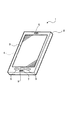
図1は、実施形態に係る携帯電話機1の外観図である。この図において、携帯電話機1は、手持ちに適した形状、たとえば、薄型箱形状の筐体2の主面(表面であって主たる操作対象となる面のこと)に透明なタッチパネル3を設けるとともに、そのタッチパネル3の背面に液晶ディスプレイやEL(Electro-Luminescence)パネルなどの二次元表示デバイスからなる表示部4を設け、また、そのタッチパネル3の上端辺側の筐体2の表面にスピーカ5を設け、さらに、そのタッチパネル3の下端辺側の筐体2の表面に1または複数の物理ボタン(ここでは一例として3個の物理ボタン6〜8)とマイクロフォン(以下、マイクという)9とを設けている。なお、筐体2の任意部分に電源スイッチやバッテリ充電用端子などが設けられているが、図では省略している。
Embodiments of the present invention will be described below with reference to the drawings, taking application to a mobile phone as an example.
First, the configuration of the embodiment will be described.
FIG. 1 is an external view of a
図2は、携帯電話機1の概念的な内部ブロック図である。この図において、携帯電話機1は、電話用無線通信部10、WiFi用無線通信部11、GPS受信部12、音声入出力部13、操作部14、表示部4、タッチパネル3、記憶部15、電源部16及び中央制御部17を備える。
FIG. 2 is a conceptual internal block diagram of the
電話用無線通信部10は、中央制御部17の制御の元、アンテナ10aを介し、最寄りの携帯電話基地局(以下、単に基地局という)17との間で無線通信によるデジタルデータの送受信を行うことを主たる役割とし、また、従たる役割として、通信中の基地局17の識別情報(基地局ID)に基づいて現在位置の測位(以下、「基地局測位」という)を行う。基地局測位の誤差は通信中の基地局17のサービスエリア(セルともいう)の広さに依存し、たとえば、半径数百mから場合によっては半径数kmである。
The telephone
WiFi用無線通信部11は、中央制御部17の制御の元、アンテナ11aを介し、最寄りのWiFiアクセスポイント(以下、単にアクセスポイントという)18との間で無線通信によるデジタルデータの送受信を行うことを主たる役割とし、また、従たる役割として、最寄りのアクセスポイント18のビーコンを捕捉し、そのビーコンに含まれる識別情報(MACアドレスやSSID等)に基づいて現在位置の測位(以下、「WiFi測位」という)を行う。WiFi測位の誤差は、最寄りのアクセスポイント18の数や、それらのアクセスポイント18からのビーコン強度及び各アクセスポイント18の密集度などによって異なり、一概にはいえないが、多くの場合、数十mから数百mである(つまり、基地局測位よりも高精度である)。
The WiFi
GPS受信部12は、中央制御部17の制御の元、複数のGPS衛星19からの電波を受信し、それぞれのGPS衛星19との距離を割り出すことによって現在位置の測位(以下、「GPS測位」という)を行う。3つの衛星が見えるところでは緯度と経度を、4つまたはそれ以上の衛星が見えるところではこれに加えてさらに高度も割り出すことができる。GPS測位は本来、米国防総省が管理する軍用である。軍用の精度は極めて高い(数十cm)が、民用にも精度を数十mに落として提供されている。この民用の精度(数十cm)は、基地局測位やWiFi測位よりも高い。したがって、3つの測位方法(基地局測位/WiFi測位/GPS測位)のうち、このGPS測位の精度が最も高い。
The
ここで、近年、衛星からの電波を受信できない屋内等(以下、屋内という)でもGPSを利用することができる技術が実用化されている。その代表は冒頭のIMESである。IMESはGPSと互換性のある信号を小型の専用装置(以下、IMES装置)から発信するというものであり、宇宙航空研究開発機構(JAXA)と測位衛星技術株式会社が共同開発した技術である。説明の便宜上、衛星からの電波を受信してGPS測位することを「屋外GPS測位」といい、IMES装置からの電波を受信してGPS測位することを「屋内GPS測位」ということにする。なお、これらを総称する場合は、前記のとおり「GPS測位」ということにする。 Here, in recent years, a technology that can use GPS even indoors (hereinafter referred to as indoors) where radio waves from satellites cannot be received has been put into practical use. The representative is IMES at the beginning. IMES transmits a signal compatible with GPS from a small dedicated device (hereinafter referred to as IMES device), and is a technology jointly developed by Japan Aerospace Exploration Agency (JAXA) and Positioning Satellite Technology Co., Ltd. For convenience of explanation, receiving an electric wave from a satellite and performing GPS positioning is referred to as “outdoor GPS positioning”, and receiving an electric wave from an IMES device and performing GPS positioning is referred to as “indoor GPS positioning”. Note that these are collectively referred to as “GPS positioning” as described above.
音声入出力部13は、中央制御部17の制御の元、マイク9で拾った音声信号をデジタルデータに変換して中央制御部17に出力したり、中央制御部17から出力されたデジタルの音声信号をアナログ信号に変換してスピーカ5から拡声したりする。
The voice input /
操作部14は、図示の例では3個の物理ボタン6〜8や不図示の電源スイッチなどを備えており、それらの物理ボタン6〜8や電源スイッチなどの操作状態に応じた信号を中央制御部17に出力する。
The
表示部4は、先にも説明したとおり、その前面に、タッチペンや人体の一部(一般的には指先)の接触を、抵抗膜方式や静電容量方式の原理で検知できるタッチパネル3を併設している。「併設」は、表示部4の前面にタッチパネル3を“接着固定”するという意味であってもよく、あるいは、“非接着”で単に動かない(面方向にずれない)という意味であってもよい。また、多くのタッチパネルは、それ自体が独立した1つの部品であるが、これに限らず、たとえば、表示部4に組み込まれた(一般的には保護ガラスと表示層との間にタッチパネル層が挟み込まれている)一体型のものであってもよい。
As described above, the display unit 4 is provided with a
記憶部15は、フラッシュメモリやシリコンディスクあるいはハードディスクなどの不揮発性の大容量記憶デバイスであり、この携帯電話機1に必要な様々なデータ(たとえば、地図情報など)を記憶保持する。
The
電源部16は、一次電池または充電可能な二次電池からなるバッテリ16aを含み、このバッテリ16aの電力から携帯電話機1の動作に必要な各種電源電圧を発生して各部に供給する。
The
中央制御部17は、コンピュータまたはマイクロコンピュータ(以下、CPU)17aや読み出し専用半導体メモリ(以下、ROM)17b及び高速半導体メモリ(以下、RAM)17cならびに不図示の周辺回路を含むプログラム制御方式の制御要素であり、あらかじめROM17bに格納されている制御プログラムなどの制御データをRAM17cにロードしてCPU17aで実行することにより、各種の処理を逐次に実行して、この携帯電話機1の全体動作を統括制御する。
The
次に、実施形態の作用をいくつかの実施例ごとに説明する。
(第1実施例)
図3は、第1実施例の制御プログラムの概略フローを示す図である。この制御プログラムは、中央制御部17のCPU17aで実行される。このフローを開始すると、まず、CPU17aはユーザによって任意に指定された目標エリアの情報を取り込む(ステップS11)。目標エリアの指定は、たとえば、タッチパネル3にソフトウェアキーボードを表示し、そのキーボードを用いてユーザが緯度経度の数値情報を直接入力して指定するようにしてもよいし、あるいは、記憶部15に保存されている地図情報を読み出して表示部4にその地図情報を表示し、ユーザによるタッチパネル3へのタッチ座標から地図上の緯度経度の数値情報を割り出して指定するようにしてもよい。
Next, the operation of the embodiment will be described for each of several examples.
(First embodiment)
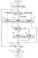
FIG. 3 is a diagram showing a schematic flow of the control program of the first embodiment. This control program is executed by the CPU 17a of the
次いで、表示部4に複数の測位方法の選択肢を表示し、そのうちの一つの測位方法をユーザに選択させる(ステップS12)。ここで、選択肢となる測位方法は、「WiFi測位」、「GPS測位」及び「基地局測位」の3つである。ユーザはこれら3つの測位方法の一つを選択する。CPU17aは、その選択結果に従い、位置の測位間隔(以下、単に測位間隔という)を設定する。すなわち、「WiFi測位」が選択された場合は測位間隔をWiFi測位用に設定し(ステップS13)、「GPS測位」が選択された場合は測位間隔を屋外GPS測位用に設定し(ステップS14)、「基地局測位」が選択された場合は測位間隔を基地局測位用に設定する(ステップS15)。 Next, a plurality of positioning method options are displayed on the display unit 4, and one of the positioning methods is selected by the user (step S12). Here, there are three positioning methods as options: “WiFi positioning”, “GPS positioning”, and “base station positioning”. The user selects one of these three positioning methods. The CPU 17a sets a positioning interval (hereinafter simply referred to as a positioning interval) according to the selection result. That is, when “WiFi positioning” is selected, the positioning interval is set for WiFi positioning (step S13), and when “GPS positioning” is selected, the positioning interval is set for outdoor GPS positioning (step S14). When “base station positioning” is selected, the positioning interval is set for base station positioning (step S15).
GPS測位とWiFi測位は、精度は高いが消費電力が大きいため、測位間隔を長くし、基地局測位は、精度は低いが消費電力が小さいため、測位間隔を短くする。このように、3つの測位方法(GPS測位、WiFi測位及び基地局測位)のそれぞれを携帯電話機1で使用した場合の消費電力を考慮し、測位間隔の長さを変えるようにする。つまり、消費電力が大きい程、測位間隔を長くする。
GPS positioning and WiFi positioning have high accuracy but high power consumption, so the positioning interval is lengthened. Base station positioning has low accuracy but low power consumption, so the positioning interval is shortened. Thus, the length of the positioning interval is changed in consideration of the power consumption when each of the three positioning methods (GPS positioning, WiFi positioning, and base station positioning) is used in the
そして、「WiFi測位」が選択された場合または「基地局測位」が選択された場合は、いずれも目標エリアに到達したか否かを判定し(ステップS16)、到達していなければステップS12以降を繰り返し、到達していれば、携帯電話機1のユーザまたは他のユーザに対する通知(ステップS17)を行った後、フローを終了する。携帯電話機1のユーザに対する通知は、たとえば、スピーカ5からの通知音で行ってもよく、あるいは、表示部4への任意の情報表示で行ってもよい。また、他のユーザに対する通知は、たとえば、あらかじめ登録されているメールアドレス宛てへの電子メールで行ってもよく、あるいは、あらかじめ登録されている携帯電話番号宛へのショートメッセージで行ってもよい。
If “WiFi positioning” is selected or “base station positioning” is selected, it is determined whether or not both have reached the target area (step S16). If it has been repeated and reached, a notification to the user of the
一方、「GPS測位」が選択された場合は、位置の測位結果が得られるまでの待ち時間(以下、測位待ち時間という)を測定し、その測位待ち時間が一定値より長いか否かを判定する(ステップS18)。 On the other hand, when “GPS positioning” is selected, the waiting time until the positioning result of the position is obtained (hereinafter referred to as positioning waiting time) is measured, and it is determined whether or not the positioning waiting time is longer than a certain value. (Step S18).
そして、測位待ち時間が一定値より長ければ、衛星からの電波を捕捉できない場所(屋内等)にいるものと判断して、測位間隔を屋外GPS測位用から屋内GPS測位用に変更し(ステップS19)、一方、測位待ち時間が一定値より長くなければ、測位間隔を屋外GPS測位用のままとし(屋内GPS測位用に変更されていれば屋外GPS測位用に戻し)(ステップS20)、次いで、目標エリアに到達したか否かを判定し(ステップS16)、到達していなければステップS12以降を繰り返し、到達していれば、携帯電話機1のユーザまたは他のユーザに対する通知(ステップS17)を行った後、フローを終了する。
If the positioning waiting time is longer than a certain value, it is determined that the radio wave from the satellite cannot be captured (such as indoors) and the positioning interval is changed from outdoor GPS positioning to indoor GPS positioning (step S19). On the other hand, if the positioning waiting time is not longer than a certain value, the positioning interval remains for outdoor GPS positioning (returns to outdoor GPS positioning if changed to indoor GPS positioning) (step S20), then It is determined whether or not the target area has been reached (step S16). If it has not reached, step S12 and subsequent steps are repeated, and if it has reached, notification to the user of the
この第1実施例では、ユーザに測位方法(WiFi測位、GPS測位、基地局測位)を選択させると共に、GPS測位が選択された場合には、測位待ち時間を測定して、その測位待ち時間が一定値より長い場合に測位間隔を屋内GPS測位用に設定する点に特徴がある。 In the first embodiment, the user selects a positioning method (WiFi positioning, GPS positioning, base station positioning), and when GPS positioning is selected, the positioning waiting time is measured and the positioning waiting time is determined. It is characterized in that the positioning interval is set for indoor GPS positioning when it is longer than a certain value.
すなわち、屋内GPS測位と屋外GPS測位は、測位信号源(GPS衛星またはIMES装置)の違いしかなく、携帯電話機1の内部動作の点ではどちらも同じである。
That is, indoor GPS positioning and outdoor GPS positioning are the same in terms of the internal operation of the
しかしながら、一般的にGPS衛星からの電波を捕捉するまでの待ち時間(測位待ち時間)は、IMES装置からの電波を捕捉するまでの待ち時間(測位待ち時間)よりも長いので、「GPS測位の測位待ち時間が一定値より長い場合は、衛星からの電波がなかなか捕捉されない状況にある」と判断することができる。 However, in general, the waiting time (positioning waiting time) until the radio wave from the GPS satellite is captured is longer than the waiting time (positioning waiting time) until the radio wave from the IMES device is captured. If the positioning waiting time is longer than a certain value, it is difficult to capture radio waves from the satellite.
そして、このような状況においては、屋内GPS測位、つまり、衛星の代わりにIMES装置からの電波を用いた測位を行うことが測位の応答性や電力消費の面で好ましいことから、第1実施例では、上記の状況の場合に、屋外GPS測位用の測位間隔から屋内GPS測位用の測位間隔に変更するようにしている。 In such a situation, it is preferable to perform indoor GPS positioning, that is, positioning using radio waves from the IMES device instead of the satellite in terms of positioning responsiveness and power consumption. Then, in the above situation, the positioning interval for outdoor GPS positioning is changed to the positioning interval for indoor GPS positioning.
したがって、第1実施例によれば、冒頭の第3従来技術における専用のサーバ(ナビゲーションサーバ)が不要であるから、コストをかけずに済み、また、ユーザの所望により、精度の高いGPS測位を行うことができるから、正確なエリア通知を行うことができ、さらに、特に屋外GPS測位と屋内GPS測位双方の測位間隔を適正化できるから、常に一定の測位間隔にしている場合に比べて、バッテリの延命化を図ることができる。 Therefore, according to the first embodiment, the dedicated server (navigation server) in the third prior art at the beginning is unnecessary, so that no cost is required, and highly accurate GPS positioning can be performed according to the user's request. Since it is possible to perform accurate area notifications, and since the positioning interval of both outdoor GPS positioning and indoor GPS positioning can be optimized in particular, the battery can be compared with the case where the positioning interval is always constant. Can prolong life.
(第2実施例)
第2実施例は、ユーザの現在位置と当該ユーザが指定した目標エリアとが離れている間は省電力性に優れた基地局測位を利用する一方、ユーザが指定した目標エリアに近いまたは目標エリアに入ったときには測位精度に優れたGPS測位もしくはWiFi測位に切り替えるようにし、これにより、コストをかけずに正確なエリア通知とバッテリの延命化を図るようにしたものである。
(Second embodiment)
In the second embodiment, while the current position of the user is away from the target area designated by the user, the base station positioning excellent in power saving is used, while the target area designated by the user is close to the target area. When entering, switching to GPS positioning or WiFi positioning with excellent positioning accuracy is performed, thereby achieving accurate area notification and extending battery life without cost.
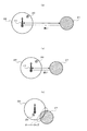
図4は、第2実施例の概念図である。この図において、星(☆)印はユーザの現在位置20を示し、ハッチング付きの円図形はユーザが指定した目標エリア21を示し、ハッチングなしの円図形は基地局測位の誤差範囲(基地局17を中心とした範囲)22を示す。
FIG. 4 is a conceptual diagram of the second embodiment. In this figure, the star (☆) mark indicates the
第2実施例では、(a)に示すように、ユーザの現在位置20と当該ユーザが指定した目標エリア21とが遠く離れている間は、省電力性に優れた基地局測位を利用するが、(b)に示すように、現在位置20がユーザが指定した目標エリア21に近いまたは目標エリア21に入ったときには測位精度に優れたGPS測位もしくはWiFi測位に切り替える。あるいは、(c)に示すように、基地局測位の誤差範囲22と目標エリア21がオーバラップしたときにも測位精度に優れたGPS測位もしくはWiFi測位に切り替える。
In the second embodiment, as shown in (a), while the user's
図5は、第2実施例の制御プログラムの概略フローを示す図である。この制御プログラムは、中央制御部17のCPU17aで実行される。このフローを開始すると、まず、CPU17aはユーザによって任意に指定された目標エリア21の情報を取り込む(ステップS21)。
FIG. 5 is a diagram showing a schematic flow of the control program of the second embodiment. This control program is executed by the CPU 17a of the
次いで、基地局測位を行い(ステップS22)、現在位置20が目標エリア21に近いか否かを判定する(ステップS23)。そして、現在位置20が目標エリア21に近くなければ、図4(a)の状態(ユーザの現在位置20と当該ユーザが指定した目標エリア21とが遠く離れている状態)にあるものと判断し、精度は劣るものの省電力性に優れた基地局測位(ステップS22)をそのまま継続する。
Next, base station positioning is performed (step S22), and it is determined whether or not the
一方、ステップS23の判定結果がYESの場合、つまり、現在位置20が目標エリア21に近い場合には、図4(b)の状態(現在位置20がユーザが指定した目標エリア21に近い状態または目標エリア21に入った状態)にある、もしくは、図4(c)の状態(基地局測位の誤差範囲22と目標エリア21がオーバラップした状態)にあるものと判断し、省電力性は劣るものの精度に優れたGPS測位またはWiFi測位に変更し(ステップS24)、変更後の測位方法を用いて測位を行う(ステップS25)。
On the other hand, if the determination result in step S23 is YES, that is, if the
次いで、測位結果(現在位置20)を取り込み、現在位置20が、目標エリア21から遠いか、目標エリア21に近いか、または、目標エリア21内(目標エリア21を示す円内)に入っているか、を判定する(ステップS26)。そして、目標エリア21から遠いと判定された場合には、精度は劣るものの省電力性に優れた基地局測位に変更して(ステップS27)ステップS22以降を繰り返し、目標エリア21に近いと判定された場合には、そのままの測位方法(省電力性は劣るものの精度に優れたGPS測位またはWiFi測位)で測位を行い(ステップS25)、目標エリア21内(目標エリア21を示す円内)に入っていると判定された場合は、携帯電話機1のユーザまたは他のユーザに対する通知(ステップS28)を行った後、フローを終了する。
Next, the positioning result (current position 20) is taken in. Whether the
この第2実施例では、ユーザの現在位置20と当該ユーザが指定した目標エリア21とが遠く離れている間は、省電力性に優れた基地局測位を利用し、また、現在位置20がユーザが指定した目標エリア21に近いまたは目標エリア21に入ったとき、もしくは、基地局測位の誤差範囲22と目標エリア21がオーバラップしたときには、測位精度に優れたGPS測位またはWiFi測位を利用する。
In the second embodiment, while the
したがって、基地局測位を利用している間の省電力効果によってバッテリの延命化を図りつつ、GPS測位またはWiFi測位を利用している間の高い測位精度によって正確なエリア通知を行うことができる。加えて、冒頭の第3従来技術における専用のサーバ(ナビゲーションサーバ)が不要であり、システムのコストアップも招かない。 Therefore, it is possible to perform accurate area notification with high positioning accuracy while using GPS positioning or WiFi positioning while extending the battery life by the power saving effect while using base station positioning. In addition, the dedicated server (navigation server) in the third prior art at the beginning is unnecessary, and the cost of the system is not increased.
(第3実施例)
第3実施例は、基地局測位の精度誤差が一定範囲を超えた場合に、基地局測位からGPS測位またはWiFi測位に切り替えるようにしたものである。携帯電話の基地局17は、携帯電話機1からの求めに応じて、その基地局17の位置情報と精度誤差とを含む情報を返す。精度誤差(携帯電話1がこの距離範囲内に存在することを示す値)は、数百m〜数kmのばらつきがある。
(Third embodiment)
In the third embodiment, when the accuracy error of the base station positioning exceeds a certain range, the base station positioning is switched to the GPS positioning or the WiFi positioning. In response to a request from the
この第3実施例では、基地局17から高い精度が返された場合は、省電力性に優れた基地局測位をそのまま利用する一方、基地局17から低い精度が返された場合は、精度に優れたGPS測位またはWiFi測位を利用するようにし、これにより、コストをかけずに正確なエリア通知とバッテリの延命化を図るようにしたものである。
In the third embodiment, when high accuracy is returned from the
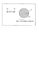
図6は、第3実施例の概念図である。この図において、星(☆)印はユーザの現在位置23を示し、ハッチング付きの円図形はユーザが指定した目標エリア24を示し、ハッチングなしの円図形は基地局測位の誤差範囲(基地局17を中心とした範囲)25を示す。
FIG. 6 is a conceptual diagram of the third embodiment. In this figure, a star (☆) indicates the
第3実施例では、(a)に示すように、基地局17から高い精度(たとえば、700m未満の精度)が返された場合は、省電力性に優れた基地局測位をそのまま利用し、また、(b)に示すように、基地局17から低い精度(たとえば、700m以上の精度)が返された場合は、精度に優れたGPS測位またはWiFi測位を利用する。
In the third embodiment, as shown in (a), when high accuracy (for example, accuracy of less than 700 m) is returned from the
図7は、第3実施例の制御プログラムの概略フローを示す図である。この制御プログラムは、中央制御部17のCPU17aで実行される。このフローを開始すると、まず、CPU17aはユーザによって任意に指定された目標エリア24の情報を取り込む(ステップS31)。
FIG. 7 is a diagram showing a schematic flow of the control program of the third embodiment. This control program is executed by the CPU 17a of the
次いで、基地局測位を行い(ステップS32)、基地局測位の精度が一定値(たとえば、700m)を超えているか否かを判定する(ステップS33)。そして、基地局測位の精度が一定値を超えていなければ、目標エリア24内(目標エリア24を示す円内)に入っているかを判定し(ステップS34)、目標エリア24内に入っていなければ、省電力性に優れた基地局測位(ステップS32)をそのまま継続し、目標エリア24内に入っていれば、携帯電話機1のユーザまたは他のユーザに対する通知(ステップS39)を行った後、フローを終了する。
Next, base station positioning is performed (step S32), and it is determined whether the accuracy of base station positioning exceeds a certain value (for example, 700 m) (step S33). If the accuracy of base station positioning does not exceed a certain value, it is determined whether or not the
一方、ステップS33の判定結果がYESの場合、つまり、基地局測位の精度が一定値を超えている場合には、図6(b)の状態(基地局17から低い精度が返された状態)にあるものと判断し、精度に優れたGPS測位またはWiFi測位に変更し(ステップS35)、変更後の測位方法を用いて測位を行う(ステップS36)。 On the other hand, if the determination result in step S33 is YES, that is, if the accuracy of base station positioning exceeds a certain value, the state of FIG. 6B (a state in which low accuracy is returned from the base station 17). The GPS positioning or the WiFi positioning with excellent accuracy is changed (step S35), and positioning is performed using the changed positioning method (step S36).
次いで、測位結果(現在位置23)を取り込み、現在位置23が、目標エリア24から遠いか、目標エリア24に近いか、または、目標エリア24内(目標エリア24を示す円内)に入っているか、を判定する(ステップS37)。そして、目標エリア24から遠いと判定された場合には、精度は劣るものの省電力性に優れた基地局測位に変更して(ステップS38)ステップS32以降を繰り返し、目標エリア24に近いと判定された場合には、そのままの測位方法(省電力性は劣るものの精度に優れたGPS測位またはWiFi測位)で測位を行い(ステップS36)、目標エリア24内(目標エリア24を示す円内)に入っていると判定された場合は、携帯電話機1のユーザまたは他のユーザに対する通知(ステップS39)を行った後、フローを終了する。
Next, the positioning result (current position 23) is taken in. Whether the
この第3実施例では、基地局17から高い精度(たとえば、700m未満の精度)が返された場合は、省電力性に優れた基地局測位をそのまま利用する一方、基地局17から低い精度(たとえば、700m以上の精度)が返された場合は、精度に優れたGPS測位またはWiFi測位を利用する。
In the third embodiment, when high accuracy (for example, accuracy of less than 700 m) is returned from the
したがって、基地局測位を利用している間の省電力効果によってバッテリの延命化を図りつつ、GPS測位またはWiFi測位を利用している間の高い測位精度によって正確なエリア通知を行うことができる。加えて、冒頭の第3従来技術における専用のサーバ(ナビゲーションサーバ)が不要であり、システムのコストアップも招かない。 Therefore, it is possible to perform accurate area notification with high positioning accuracy while using GPS positioning or WiFi positioning while extending the battery life by the power saving effect while using base station positioning. In addition, the dedicated server (navigation server) in the third prior art at the beginning is unnecessary, and the cost of the system is not increased.
このように、第1実施例〜第3実施例によれば、コストをかけずに正確なエリア通知とバッテリの延命化を図ることができるという効果を得ることができる。 Thus, according to the first to third embodiments, it is possible to obtain an effect that accurate area notification and battery life extension can be achieved without cost.
さらに、第1実施例〜第3実施例に、以下の実施例(確実な通知を行うことを意図したもの)を組み合わせてもよい。
(第4実施例)
図8は、第4実施例の概念図である。この図において、二つの星(☆)印はそれぞれユーザの移動前の位置26と時速Ymで移動した後の位置26′を示し、円図形はユーザが指定した半径Xmの目標エリア27を示す。
Furthermore, the following embodiments (those intended for reliable notification) may be combined with the first to third embodiments.
(Fourth embodiment)
FIG. 8 is a conceptual diagram of the fourth embodiment. In this figure, two stars (☆) indicate a
今、X=1、Y=60とすると、目標エリア27の半径は1Km、ユーザの移動速度は毎時60Kmになる。ここで、ユーザが指定した目標エリア27で2回まで位置測位させることを考えると、2Km÷2回=1Kmなので、1Kmごとの計測が必要になる。よって、1Km÷1Km/分=1分ごとに計測を行うことになる。
Assuming that X = 1 and Y = 60, the radius of the
このことから、通知のタイミングを逃さないようにして確実な通知を行うための適正な測位間隔Zは、以下の計算式で与えられる。
測位間隔Z=(2X÷T)÷(Y÷60)
ただし、X:目標エリア27の半径(Km)
Y:ユーザの移動時速(Km/h)
T:目標エリア27内で測位回数(回)
(2X÷T[Km]ごとに計測が必要)
Therefore, an appropriate positioning interval Z for performing reliable notification without missing the notification timing is given by the following calculation formula.
Positioning interval Z = (2X ÷ T) ÷ (Y ÷ 60)
X: radius of target area 27 (Km)
Y: Speed of movement of the user (Km / h)
T: Number of positioning times in target area 27 (times)
(Measurement is required every 2X ÷ T [Km])
図9は、第4実施例の制御プログラムの概略フローを示す図である。この制御プログラムは、中央制御部17のCPU17aで実行される。このフローを開始すると、まず、CPU17aはユーザによって任意に指定された目標エリア27の情報を取り込む(ステップS41)。
FIG. 9 is a diagram showing a schematic flow of the control program of the fourth embodiment. This control program is executed by the CPU 17a of the
次いで、3つの測位方法(基地局測位、GPS測位、WiFi測位)のいずれかを用いて位置測位を行い(ステップS42)、所定の測位間隔Zの経過を待ち(ステップS43)、同じく3つの測位方法(基地局測位、GPS測位、WiFi測位)のいずれかを用いて位置測位を行う(ステップS44)。 Next, position measurement is performed using any one of the three positioning methods (base station positioning, GPS positioning, WiFi positioning) (step S42), and a predetermined positioning interval Z is waited for (step S43). Positioning is performed using one of the methods (base station positioning, GPS positioning, WiFi positioning) (step S44).
そして、測位地点が目標エリア27内(目標エリア27の円内)にあるか否かを判定し(ステップS45)、目標エリア27内にあれば、携帯電話機1のユーザまたは他のユーザに対する通知(ステップS47)を行った後、フローを終了する。
Then, it is determined whether or not the positioning point is within the target area 27 (in the circle of the target area 27) (step S45), and if it is within the
一方、目標エリア27内になければ、移動速度Yと目標エリア27の半径Xとを元に前記の計算式に従って測位間隔Zを求め(ステップS46)、再び、ステップS43以降を繰り返す。
On the other hand, if it is not within the
このように第4実施例では、目標エリア27の半径X、ユーザの移動時速Y及び目標エリア27内での測位回数Tに基づいて、通知のタイミングを逃さないようにするための適正な測位間隔Zを求めるようにしたから、前記の第1実施例〜第3実施例と組み合わせることにより、第1実施例〜第3実施例の効果(コストをかけずに正確なエリア通知とバッテリの延命化を図ることができる)に加えて、さらに、ユーザが指定した目標エリアに到達したときに確実な通知を行うことができるという効果も得ることができる。
As described above, in the fourth embodiment, an appropriate positioning interval for not missing the notification timing based on the radius X of the
(第5実施例)
第5実施例は、GPS測位や基地局測位またはWiFi測位で取得した「過去(直前)の測位位置」と「現在の測位位置」の2点間を直線で補間し、その直線がユーザが指定した目標エリアを通過したかどうかを調べ、通過していた場合は通知漏れがあったと判断して通知(事後通知)を行うようにしたものである。
(5th Example)
In the fifth embodiment, a straight line is interpolated between two points of “previous (previous) positioning position” and “current positioning position” acquired by GPS positioning, base station positioning, or WiFi positioning, and the straight line is designated by the user. It is determined whether or not the target area has been passed, and if it has passed, it is determined that there has been a notification failure and a notification (post-notification) is made.
図10は、第5実施例の概念図である。この図において、(a)は、現在の測位位置29だけの場合を示し、(b)と(c)は、過去(直前)の測位位置28と現在の測位位置29の2つが存在する場合を示している。この第5実施例では、(b)や(c)のように、過去(直前)の測位位置28と現在の測位位置29の2つが存在する場合において、それらの2点を結ぶ直線31を引き、その直線31がユーザが指定した目標エリア30を通過したか否かを判定し、通過していた場合(ここでは(b)の場合)に、通知漏れがあったと判断して事後通知を行うようにしたものである。
FIG. 10 is a conceptual diagram of the fifth embodiment. In this figure, (a) shows the case of only the
図11は、第5実施例の制御プログラムの概略フローを示す図である。この制御プログラムは、中央制御部17のCPU17aで実行される。このフローを開始すると、まず、CPU17aはユーザによって任意に指定された目標エリア30の情報を取り込む(ステップS51)。
FIG. 11 is a diagram showing a schematic flow of the control program of the fifth embodiment. This control program is executed by the CPU 17a of the
次いで、3つの測位方法(基地局測位、GPS測位、WiFi測位)のいずれかを用いて位置測位を行い(ステップS52)、所定の測位間隔Zの経過を待ち(ステップS53)、同じく3つの測位方法(基地局測位、GPS測位、WiFi測位)のいずれかを用いて位置測位を行う(ステップS54)。 Next, position measurement is performed using any one of the three positioning methods (base station positioning, GPS positioning, WiFi positioning) (step S52), and the passage of a predetermined positioning interval Z is waited (step S53). Position positioning is performed using one of the methods (base station positioning, GPS positioning, WiFi positioning) (step S54).
そして、直前と今回の2地点間を直線補間し、その直線31が目標エリア30内(目標エリア30の円内)を通過したか否かを判定し(ステップS55)、通過していなければ、再びステップS53以降を実行する一方、通過していれば、携帯電話機1のユーザまたは他のユーザに対する通知(ステップS56)を行った後、フローを終了する。
Then, linear interpolation is performed between the previous and next two points, and it is determined whether or not the
このように第5実施例では、「過去(直前)の測位位置」と「現在の測位位置」の2点間を直線31で補間し、その直線31がユーザが指定した目標エリア30を通過したかどうかを調べ、通過していた場合は通知漏れがあったと判断して事後通知を行うようにしたので、通知漏れを回避することができる。
As described above, in the fifth embodiment, the
したがって、前記の第1実施例〜第3実施例と組み合わせることにより、第1実施例〜第3実施例の効果(コストをかけずに正確なエリア通知とバッテリの延命化を図ることができる)に加えて、さらに、事後的ではあるものの、確実な通知を行うことができるという効果も得ることができる。 Therefore, by combining with the first to third embodiments, the effects of the first to third embodiments (accurate area notification and longer battery life can be achieved without cost). In addition, although it is a post facto, it is possible to obtain an effect that a reliable notification can be performed.
第5実施例における通知(ステップS56の通知)を行う際は、事後的な通知である旨をユーザに知らせるようにしてもよい。たとえば、「目標エリアを通り過ぎました」などの音声メッセージを用いてもよい。 When the notification in the fifth embodiment (the notification in step S56) is performed, the user may be notified that it is a post-event notification. For example, a voice message such as “passed the target area” may be used.
(第6実施例)
GPS測位やWiFi測位は高精度な測位であるため、若干の測位許容誤差を持たせることによって、通知漏れを回避することができる。
(Sixth embodiment)
Since GPS positioning and WiFi positioning are highly accurate positioning, omission of notification can be avoided by giving a slight positioning tolerance.
図12は、第6実施例の概念図である。(a)において、星(☆)印はユーザの現在位置32、ハッチング付きの円図形はユーザによって指定された目標エリア33、ハッチングなしの大きな円図形は基地局測位の精度(基地局17を中心とした範囲)34を示している。
FIG. 12 is a conceptual diagram of the sixth embodiment. In (a), the star (☆) is the
GPS測位やWiFi測位は精度が高いのが利点であるが、その利点故に、一方で、ユーザの現在位置32が正確にユーザが指定した目標エリア33の円内に入らなければ通知を行うことができないという欠点がある。
GPS positioning and WiFi positioning have the advantage of high accuracy, but because of this advantage, if the user's
第6実施形態では、この欠点を補うために、(b)に示すように、GPS測位やWiFi測位の精度に一定量の測位誤差(たとえば、100m)を付与し、その測位誤差を含む測位範囲36とユーザが指定した目標エリア33とが交わるか、または接したときに通知を行うようにした。
In the sixth embodiment, in order to compensate for this drawback, as shown in (b), a certain amount of positioning error (for example, 100 m) is given to the accuracy of GPS positioning or WiFi positioning, and the positioning range including the positioning error. Notification is made when 36 and the
図13は、第6実施例の制御プログラムの概略フローを示す図である。この制御プログラムは、中央制御部17のCPU17aで実行される。このフローを開始すると、まず、CPU17aはユーザによって任意に指定された目標エリア33の情報を取り込む(ステップS61)。
FIG. 13 is a diagram showing a schematic flow of the control program of the sixth embodiment. This control program is executed by the CPU 17a of the
次いで、3つの測位方法(基地局測位、GPS測位、WiFi測位)のいずれかを用いて位置測位を行い(ステップS62)、現在の測位がGPS測位またはWiFi測位であるか否かを判定し(ステップS63)、GPS測位またはWiFi測位でない場合は、現在の測位が基地局測位であると判断して、測位許容誤差を付けずに(ステップS66)、目標エリア33内であるか否かを判定し(ステップS67)、目標エリア33内でなければ、ステップS62以降を繰り返し、目標エリア33内であれば、携帯電話機1のユーザまたは他のユーザに対する通知(ステップS68)を行った後、フローを終了する。
Next, position positioning is performed using one of the three positioning methods (base station positioning, GPS positioning, WiFi positioning) (step S62), and it is determined whether the current positioning is GPS positioning or WiFi positioning ( Step S63), if it is not GPS positioning or WiFi positioning, it is determined that the current positioning is base station positioning, and it is determined whether or not it is within the
一方、ステップS63の判定結果がYESの場合、つまり、現在の測位がGPS測位またはWiFi測位である場合には、所定の測位許容誤差(たとえば、100m)を付与し(ステップS64)、その測位誤差を含む測位範囲36とユーザが指定した目標エリア33の円とが交わっているか、または接しているか否かを判定し(ステップS65)、その判定結果がNOの場合は、ステップS62以降を繰り返し、その判定結果がYESの場合は、携帯電話機1のユーザまたは他のユーザに対する通知(ステップS68)を行った後、フローを終了する。
On the other hand, if the determination result in step S63 is YES, that is, if the current positioning is GPS positioning or WiFi positioning, a predetermined positioning tolerance (for example, 100 m) is given (step S64), and the positioning error It is determined whether or not the positioning range 36 including the circle of the
このように第6実施例では、精度に優れたGPS測位やWiFi測位を利用している際に、一時的に精度を落として目標エリア33への到達判断を行うので、高精度故の通知漏れを防止することができる。
As described above, in the sixth embodiment, when GPS positioning or WiFi positioning with excellent accuracy is used, the accuracy is temporarily lowered and determination of arrival at the
したがって、前記の第1実施例〜第3実施例と組み合わせることにより、第1実施例〜第3実施例の効果(コストをかけずに正確なエリア通知とバッテリの延命化を図ることができる)に加えて、さらに、多少のずれ(誤差)を伴うものの、確実な通知を行うことができるという効果も得ることができる。 Therefore, by combining with the first to third embodiments, the effects of the first to third embodiments (accurate area notification and longer battery life can be achieved without cost). In addition, although there is a slight deviation (error), it is possible to obtain an effect that reliable notification can be performed.
この第6実施例における通知(ステップS68の通知)を行う際も、多少のずれ(誤差)を伴う通知である旨をユーザに知らせるようにしてもよい。たとえば、「概ね目標エリア付近に到達しました」などの音声メッセージを用いてもよい。 When performing the notification in the sixth embodiment (the notification in step S68), the user may be notified that the notification is accompanied by a slight deviation (error). For example, a voice message such as “almost reached the target area” may be used.
なお、消費電力を抑えられるGPS機能とモーションセンサーによる自律測位とを組み合わせた「ハイブリッドGPS」もあるが、この「ハイブリッドGPS」と基地局測位との組み合わせも、以上の各実施例に適用することが可能である。これによれば、さらなる省電力化を図ることができる。 There is also a “hybrid GPS” that combines the GPS function that can reduce power consumption and autonomous positioning by a motion sensor, but the combination of this “hybrid GPS” and base station positioning should also be applied to each of the above embodiments. Is possible. According to this, further power saving can be achieved.
また、第2実施例において、直前の位置と現在の位置を解析したユーザの進行方向を元に、ユーザが指定した目的の場所から遠ざかっている場合は消費電力の少ない基地局測位を行ってもよい。同様に、第4実施例においても、ユーザが指定した目的の場所から遠ざかっている場合は、測位間隔を次から長くしてもよい。 Further, in the second embodiment, based on the traveling direction of the user who analyzed the immediately preceding position and the current position, the base station positioning with low power consumption can be performed when moving away from the target location designated by the user. Good. Similarly, in the fourth embodiment, when the user is away from the target location designated by the user, the positioning interval may be extended from the next.
以上の説明では、携帯電話機への適用を例にしたが、これに限定されない。位置測位の機能を有するとともに、冒頭で述べたエリア通知などのサービスを利用することができるパーソナルコンピュータをはじめとした電子機器一般に広く適用することができる。 In the above description, application to a mobile phone is taken as an example, but the present invention is not limited to this. The present invention can be widely applied to general electronic devices such as personal computers that have a function of positioning and can use services such as area notification described at the beginning.
以下、本発明の特徴を付記する。
上記の実施形態の一部または全部は、以下の付記のようにも記載されうるが、以下には限られない。
(付記1)
付記1は、屋外GPS測位または屋内GPS測位のいずれかを行って現在位置を取得する測位手段と、
前記測位手段によって前記屋外GPS測位が行われている際の測位待ち時間を計測する計測手段と、
前記計測手段によって計測された前記測位待ち時間が一定値よりも長いか否かを判定する判定手段と、
前記測位待ち時間が一定値よりも長い場合は前記測位手段の測位間隔を屋内GPS測位用に設定し、前記測位待ち時間が一定値よりも長くない場合は前記測位手段の測位間隔を屋外GPS測位用に設定する設定手段と
を備えたことを特徴とするエリア通知装置である。
付記1によれば、コストをかけずに正確なエリア通知とバッテリの延命化を図ることができる。
(付記2)
付記2は、基地局測位、GPS測位またはWiFi測位のいずれか行って現在位置を取得する測位手段と、
前記現在位置と任意の目標エリアとが遠く離れている間は前記基地局測位を利用するように前記測位手段を制御し、前記現在位置が前記目標エリアに近いまたは目標エリアに入ったとき、もしくは、前記基地局測位の誤差範囲と前記目標エリアがオーバラップしたときには前記基地局測位に代えて前記GPS測位またはWiFi測位を利用するように前記測位手段を制御する制御手段と
を備えたことを特徴とするエリア通知装置である。
付記2によれば、コストをかけずに正確なエリア通知とバッテリの延命化を図ることができる。
(付記3)
付記3は、基地局測位、GPS測位またはWiFi測位のいずれか行って現在位置を取得する測位手段と、
前記基地局測位を行っている際の測位精度誤差が一定範囲を超えた場合に、前記基地局測位に代えて前記GPS測位またはWiFi測位を利用するように前記測位手段を制御する制御手段と
を備えたことを特徴とするエリア通知装置である。
付記3によれば、コストをかけずに正確なエリア通知とバッテリの延命化を図ることができる。
(付記4)
付記4は、前記目標エリアの半径、前記現在位置の移動時速及び前記目標エリア内での測位回数に基づいて、前記測位手段における測位間隔を動的に設定する測位間隔設定手段をさらに備えたことを特徴とする付記1〜3のいずれかに記載のエリア通知装置である。
付記4によれば、付記1〜3の効果に加えて、さらに確実な通知を行うことができる。
(付記5)
付記5は、前記現在位置の移動前と移動後の2点間を直線で補間する補間手段と、
当該直線が前記目標エリアを通過したときに通知を行う通知手段と
をさらに備えたことを特徴とする付記1〜3のいずれかに記載のエリア通知装置である。
付記5によれば、付記1〜3の効果に加えて、さらに確実な通知を行うことができる。
(付記6)
付記6は、前記測位手段の測位精度を意図的に落とす精度低下手段をさらに備えたことを特徴とする付記1〜3のいずれかに記載のエリア通知装置である。
付記6によれば、付記1〜3の効果に加えて、さらに確実な通知を行うことができる。
(付記7)
付記7は、屋外GPS測位または屋内GPS測位のいずれかを行って現在位置を取得する測位工程と、
前記測位工程によって前記屋外GPS測位が行われている際の測位待ち時間を計測する計測工程と、
前記計測工程によって計測された前記測位待ち時間が一定値よりも長いか否かを判定する判定工程と、
前記測位待ち時間が一定値よりも長い場合は前記測位工程の測位間隔を屋内GPS測位用に設定し、前記測位待ち時間が一定値よりも長くない場合は前記測位手段の測位間隔を屋外GPS測位用に設定する設定工程と
を含むことを特徴とするエリア通知方法である。
付記7によれば、コストをかけずに正確なエリア通知とバッテリの延命化を図ることができる。
(付記8)
付記8は、コンピュータに、
屋外GPS測位または屋内GPS測位のいずれかを行って現在位置を取得する測位手段、
前記測位手段によって前記屋外GPS測位が行われている際の測位待ち時間を計測する計測手段、
前記計測手段によって計測された前記測位待ち時間が一定値よりも長いか否かを判定する判定手段、
前記測位待ち時間が一定値よりも長い場合は前記測位手段の測位間隔を屋内GPS測位用に設定し、前記測位待ち時間が一定値よりも長くない場合は前記測位手段の測位間隔を屋外GPS測位用に設定する設定手段
としての機能を与えることを特徴とするプログラムである。
付記8によれば、コストをかけずに正確なエリア通知とバッテリの延命化を図ることができる。
The features of the present invention will be described below.
A part or all of the above-described embodiment can be described as in the following supplementary notes, but is not limited thereto.
(Appendix 1)
Measuring means for measuring a positioning waiting time when the outdoor GPS positioning is performed by the positioning means;
Determining means for determining whether the positioning waiting time measured by the measuring means is longer than a certain value;
When the positioning waiting time is longer than a certain value, the positioning interval of the positioning means is set for indoor GPS positioning, and when the positioning waiting time is not longer than a certain value, the positioning interval of the positioning means is set to outdoor GPS positioning. An area notification device comprising: setting means for setting for use.
According to
(Appendix 2)
Controlling the positioning means to use the base station positioning while the current position and an arbitrary target area are far apart, and when the current position is close to or enters the target area, or Control means for controlling the positioning means to use the GPS positioning or WiFi positioning instead of the base station positioning when the error range of the base station positioning and the target area overlap. The area notification device.
According to
(Appendix 3)
Control means for controlling the positioning means to use the GPS positioning or WiFi positioning instead of the base station positioning when a positioning accuracy error when performing the base station positioning exceeds a certain range; An area notification device comprising:
According to
(Appendix 4)
Appendix 4 further includes positioning interval setting means for dynamically setting a positioning interval in the positioning means based on the radius of the target area, the moving speed of the current position, and the number of positioning times in the target area. The area notification device according to any one of
According to Supplementary Note 4, in addition to the effects of
(Appendix 5)
The area notification device according to any one of
According to
(Appendix 6)
According to
(Appendix 7)
A measuring step of measuring a positioning waiting time when the outdoor GPS positioning is performed by the positioning step;
A determination step of determining whether or not the positioning waiting time measured by the measurement step is longer than a certain value;
When the positioning waiting time is longer than a certain value, the positioning interval of the positioning process is set for indoor GPS positioning, and when the positioning waiting time is not longer than a certain value, the positioning interval of the positioning means is set to outdoor GPS positioning. An area notification method characterized by including a setting step for setting for use.
According to
(Appendix 8)
Positioning means for obtaining the current position by performing either outdoor GPS positioning or indoor GPS positioning,
Measuring means for measuring a positioning waiting time when the outdoor GPS positioning is performed by the positioning means;
Determination means for determining whether or not the positioning waiting time measured by the measuring means is longer than a certain value,
When the positioning waiting time is longer than a certain value, the positioning interval of the positioning means is set for indoor GPS positioning, and when the positioning waiting time is not longer than a certain value, the positioning interval of the positioning means is set to outdoor GPS positioning. It is a program characterized by giving a function as a setting means for setting.
According to
1 携帯電話機(エリア通知装置)
10 電話用無線通信部(測位手段)
11 WiFi用無線通信部(測位手段)
12 GPS受信部(測位手段)
17 中央制御部(計測手段)
1 Mobile phone (area notification device)
10 Wireless communication unit for telephone (positioning means)
11 WiFi wireless communication unit (positioning means)
12 GPS receiver (positioning means)
17 Central control unit (measuring means)
Claims (7)
前記測位手段によって前記屋外GPS測位が行われている際の測位待ち時間を計測する計測手段と、
前記計測手段によって計測された前記測位待ち時間が一定値よりも長いか否かを判定する判定手段と、
前記測位待ち時間が一定値よりも長い場合は前記測位手段の測位間隔を屋内GPS測位用に設定し、前記測位待ち時間が一定値よりも長くない場合は前記測位手段の測位間隔を屋外GPS測位用に設定する設定手段と、
を備えるとともに、
さらに、前記現在位置の移動前と移動後の2点間を直線で補間する補間手段と、
当該直線が目標エリアを通過したときに通知を行う通知手段と
を備えたことを特徴とするエリア通知装置。 Positioning means for obtaining the current position by performing either outdoor GPS positioning or indoor GPS positioning;
Measuring means for measuring a positioning waiting time when the outdoor GPS positioning is performed by the positioning means;
Determining means for determining whether the positioning waiting time measured by the measuring means is longer than a certain value;
When the positioning waiting time is longer than a certain value, the positioning interval of the positioning means is set for indoor GPS positioning, and when the positioning waiting time is not longer than a certain value, the positioning interval of the positioning means is set to outdoor GPS positioning. Setting means to set for
With
Further, an interpolation means for interpolating between the two points before and after the movement of the current position with a straight line;
An area notification device comprising: notification means for notifying when the straight line passes through the target area.
前記現在位置と任意の目標エリアとが遠く離れている間は前記基地局測位を利用するように前記測位手段を制御し、前記現在位置が前記目標エリアに近いまたは目標エリアに入ったとき、もしくは、前記基地局測位の誤差範囲と前記目標エリアがオーバラップしたときには前記基地局測位に代えて前記GPS測位またはWiFi測位を利用するように前記測位手段を制御する制御手段と、
を備えるとともに、
さらに、前記現在位置の移動前と移動後の2点間を直線で補間する補間手段と、
当該直線が目標エリアを通過したときに通知を行う通知手段と
を備えたことを特徴とするエリア通知装置。 Positioning means for acquiring the current position by performing any of base station positioning, GPS positioning, or WiFi positioning;
Controlling the positioning means to use the base station positioning while the current position and an arbitrary target area are far apart, and when the current position is close to or enters the target area, or Control means for controlling the positioning means to use the GPS positioning or WiFi positioning instead of the base station positioning when the error range of the base station positioning and the target area overlap;
With
Further, an interpolation means for interpolating between the two points before and after the movement of the current position with a straight line;
An area notification device comprising: notification means for notifying when the straight line passes through the target area.
前記基地局測位を行っている際の測位精度誤差が一定範囲を超えた場合に、前記基地局測位に代えて前記GPS測位またはWiFi測位を利用するように前記測位手段を制御する制御手段と、
を備えるとともに、
さらに、前記現在位置の移動前と移動後の2点間を直線で補間する補間手段と、
当該直線が目標エリアを通過したときに通知を行う通知手段と
を備えたことを特徴とするエリア通知装置。 Positioning means for acquiring the current position by performing any of base station positioning, GPS positioning, or WiFi positioning;
Control means for controlling the positioning means to use the GPS positioning or WiFi positioning instead of the base station positioning when the positioning accuracy error when performing the base station positioning exceeds a certain range;
With
Further, an interpolation means for interpolating between the two points before and after the movement of the current position with a straight line;
An area notification device comprising: notification means for notifying when the straight line passes through the target area.
前記複数の工程は、
屋外GPS測位または屋内GPS測位のいずれかを行って現在位置を取得する測位工程と、
前記測位工程によって前記屋外GPS測位が行われている際の測位待ち時間を計測する計測工程と、
前記計測工程によって計測された前記測位待ち時間が一定値よりも長いか否かを判定する判定工程と、
前記測位待ち時間が一定値よりも長い場合は前記測位工程の測位間隔を屋内GPS測位用に設定し、前記測位待ち時間が一定値よりも長くない場合は前記測位手段の測位間隔を屋外GPS測位用に設定する設定工程と、
を含むとともに、
さらに、前記現在位置の移動前と移動後の2点間を直線で補間する補間工程と、
当該直線が目標エリアを通過したときに通知を行う通知工程と
を含むことを特徴とするエリア通知方法。 An area notification method composed of a plurality of processes mainly using a computer,
The plurality of steps include
A positioning step of performing either outdoor GPS positioning or indoor GPS positioning to obtain a current position;
A measuring step of measuring a positioning waiting time when the outdoor GPS positioning is performed by the positioning step;
A determination step of determining whether or not the positioning waiting time measured by the measurement step is longer than a certain value;
When the positioning waiting time is longer than a certain value, the positioning interval of the positioning process is set for indoor GPS positioning, and when the positioning waiting time is not longer than a certain value, the positioning interval of the positioning means is set to outdoor GPS positioning. A setting process to set for
Including
Further, an interpolation step for interpolating between the two points before and after the movement of the current position with a straight line;
A notification step of notifying when the straight line passes through the target area.
屋外GPS測位または屋内GPS測位のいずれかを行って現在位置を取得する測位手段、
前記測位手段によって前記屋外GPS測位が行われている際の測位待ち時間を計測する計測手段、
前記計測手段によって計測された前記測位待ち時間が一定値よりも長いか否かを判定する判定手段、
前記測位待ち時間が一定値よりも長い場合は前記測位手段の測位間隔を屋内GPS測位用に設定し、前記測位待ち時間が一定値よりも長くない場合は前記測位手段の測位間隔を屋外GPS測位用に設定する設定手段、
前記現在位置の移動前と移動後の2点間を直線で補間する補間手段、
当該直線が目標エリアを通過したときに通知を行う通知手段
としての機能を与えることを特徴とするプログラム。 On the computer,
Positioning means for obtaining the current position by performing either outdoor GPS positioning or indoor GPS positioning,
Measuring means for measuring a positioning waiting time when the outdoor GPS positioning is performed by the positioning means;
Determination means for determining whether or not the positioning waiting time measured by the measuring means is longer than a certain value,
When the positioning waiting time is longer than a certain value, the positioning interval of the positioning means is set for indoor GPS positioning, and when the positioning waiting time is not longer than a certain value, the positioning interval of the positioning means is set to outdoor GPS positioning. Setting means to set for
Interpolation means for interpolating between the two points before and after the movement of the current position by a straight line;
A program that provides a function as a notification means for notifying when the straight line passes through a target area.
Priority Applications (1)
| Application Number | Priority Date | Filing Date | Title |
|---|---|---|---|
| JP2013007664A JP6048663B2 (en) | 2013-01-18 | 2013-01-18 | Area notification device, area notification method and program |
Applications Claiming Priority (1)
| Application Number | Priority Date | Filing Date | Title |
|---|---|---|---|
| JP2013007664A JP6048663B2 (en) | 2013-01-18 | 2013-01-18 | Area notification device, area notification method and program |
Publications (2)
| Publication Number | Publication Date |
|---|---|
| JP2014138392A JP2014138392A (en) | 2014-07-28 |
| JP6048663B2 true JP6048663B2 (en) | 2016-12-21 |
Family
ID=51415660
Family Applications (1)
| Application Number | Title | Priority Date | Filing Date |
|---|---|---|---|
| JP2013007664A Expired - Fee Related JP6048663B2 (en) | 2013-01-18 | 2013-01-18 | Area notification device, area notification method and program |
Country Status (1)
| Country | Link |
|---|---|
| JP (1) | JP6048663B2 (en) |
Families Citing this family (4)
| Publication number | Priority date | Publication date | Assignee | Title |
|---|---|---|---|---|
| US9813863B2 (en) * | 2015-08-06 | 2017-11-07 | Qualcomm Incorporated | Enhanced passive positioning with adaptive active positioning |
| JP6871713B2 (en) * | 2016-10-19 | 2021-05-12 | 株式会社Nttドコモ | Location information identification device |
| CN109597024B (en) * | 2018-11-19 | 2020-05-12 | 南京财经大学 | Indoor area positioning method and system based on asynchronous sensing data |
| JP7352715B1 (en) * | 2022-12-07 | 2023-09-28 | Kddi株式会社 | Information processing device and information processing method |
Family Cites Families (7)
| Publication number | Priority date | Publication date | Assignee | Title |
|---|---|---|---|---|
| JP2002320254A (en) * | 2001-04-20 | 2002-10-31 | Pioneer Electronic Corp | Mobile communication apparatus and its position detection method |
| JP3826807B2 (en) * | 2002-02-13 | 2006-09-27 | 日本電気株式会社 | Positioning system in mobile communication network |
| JP2003284123A (en) * | 2002-03-22 | 2003-10-03 | Matsushita Electric Works Ltd | Positional information terminal |
| JP2008180582A (en) * | 2007-01-24 | 2008-08-07 | Mitsubishi Electric Corp | Mobile communication terminal apparatus |
| JP5004352B2 (en) * | 2007-12-18 | 2012-08-22 | シャープ株式会社 | Mobile station apparatus, mobile station apparatus control method, and base station apparatus |
| JP5685828B2 (en) * | 2010-03-31 | 2015-03-18 | 富士通株式会社 | Portable portable terminal, positioning program and positioning system for portable portable terminal |
| JP2012169719A (en) * | 2011-02-10 | 2012-09-06 | Nec Casio Mobile Communications Ltd | Mobile communication terminal, network selection method by mobile communication terminal, and program |
-
2013
- 2013-01-18 JP JP2013007664A patent/JP6048663B2/en not_active Expired - Fee Related
Also Published As
| Publication number | Publication date |
|---|---|
| JP2014138392A (en) | 2014-07-28 |
Similar Documents
| Publication | Publication Date | Title |
|---|---|---|
| EP2372306B1 (en) | Method and apparatus for efficiently using a battery in a smartphone having a navigation system | |
| US9191781B2 (en) | Use of wireless access point ID for position determination | |
| US8228234B2 (en) | Power saving system and method for mobile computing device | |
| EP2622920B1 (en) | Non-transient computer readable storage medium and mobile computing device employing matching of access point identifiers | |
| US8396661B2 (en) | Using relative position data in a mobile computing device | |
| US8395547B2 (en) | Location tracking for mobile computing device | |
| EP2462779B1 (en) | Displaying image data and geographic element data | |
| US20110285591A1 (en) | Correlating contextual data and position data to improve location based services | |
| CN104956236A (en) | Survey techniques for generating location fingerprint data | |
| US20150331114A1 (en) | Systems and methods for dynamically determining position | |
| CN108055642B (en) | Control method and device of positioning module, storage medium and mobile terminal | |
| US20080234928A1 (en) | Location based services using altitude | |
| US20090040370A1 (en) | Displaying image data and geographic element data | |
| CN107431523B (en) | Wireless electronic device and method of antenna selection in wireless electronic device | |
| JP6048663B2 (en) | Area notification device, area notification method and program | |
| JP2009121885A (en) | Positioning system and vehicle-mounted unit | |
| JP5356953B2 (en) | Position positioning device, position positioning method and position positioning program | |
| US20210144786A1 (en) | Location source control | |
| JP2020030104A (en) | Radio communication device, area information providing device, system, method and program | |
| US20160007155A1 (en) | Method and apparatus for providing information regarding a device | |
| JP2016011918A (en) | Positioning system, positioning device, storage device, and positioning method | |
| JP2015068674A (en) | Positioning device, positioning method, and program | |
| CN108036795B (en) | Path acquisition method and device and mobile terminal | |
| JP5795546B2 (en) | Route guidance system, route guidance device, route guidance method, and computer program | |
| JP2012127722A (en) | Method and device for efficiently using battery in smart-phone provided with navigation system |
Legal Events
| Date | Code | Title | Description |
|---|---|---|---|
| A711 | Notification of change in applicant |
Free format text: JAPANESE INTERMEDIATE CODE: A711 Effective date: 20150618 |
|
| A621 | Written request for application examination |
Free format text: JAPANESE INTERMEDIATE CODE: A621 Effective date: 20151203 |
|
| A977 | Report on retrieval |
Free format text: JAPANESE INTERMEDIATE CODE: A971007 Effective date: 20160630 |
|
| A131 | Notification of reasons for refusal |
Free format text: JAPANESE INTERMEDIATE CODE: A131 Effective date: 20160704 |
|
| A521 | Written amendment |
Free format text: JAPANESE INTERMEDIATE CODE: A523 Effective date: 20160805 |
|
| A131 | Notification of reasons for refusal |
Free format text: JAPANESE INTERMEDIATE CODE: A131 Effective date: 20160829 |
|
| A521 | Written amendment |
Free format text: JAPANESE INTERMEDIATE CODE: A523 Effective date: 20160920 |
|
| TRDD | Decision of grant or rejection written | ||
| A01 | Written decision to grant a patent or to grant a registration (utility model) |
Free format text: JAPANESE INTERMEDIATE CODE: A01 Effective date: 20161026 |
|
| A61 | First payment of annual fees (during grant procedure) |
Free format text: JAPANESE INTERMEDIATE CODE: A61 Effective date: 20161108 |
|
| R150 | Certificate of patent or registration of utility model |
Ref document number: 6048663 Country of ref document: JP Free format text: JAPANESE INTERMEDIATE CODE: R150 |
|
| LAPS | Cancellation because of no payment of annual fees |