JP4926891B2 - Geographic information system and geographic information management method - Google Patents
Geographic information system and geographic information management method Download PDFInfo
- Publication number
- JP4926891B2 JP4926891B2 JP2007223789A JP2007223789A JP4926891B2 JP 4926891 B2 JP4926891 B2 JP 4926891B2 JP 2007223789 A JP2007223789 A JP 2007223789A JP 2007223789 A JP2007223789 A JP 2007223789A JP 4926891 B2 JP4926891 B2 JP 4926891B2
- Authority
- JP
- Japan
- Prior art keywords
- data
- map
- attribute data
- attribute
- shape
- Prior art date
- Legal status (The legal status is an assumption and is not a legal conclusion. Google has not performed a legal analysis and makes no representation as to the accuracy of the status listed.)
- Active
Links
Images


Classifications
-
- G—PHYSICS
- G06—COMPUTING; CALCULATING OR COUNTING
- G06F—ELECTRIC DIGITAL DATA PROCESSING
- G06F16/00—Information retrieval; Database structures therefor; File system structures therefor
- G06F16/20—Information retrieval; Database structures therefor; File system structures therefor of structured data, e.g. relational data
- G06F16/29—Geographical information databases
Landscapes
- Engineering & Computer Science (AREA)
- Databases & Information Systems (AREA)
- Theoretical Computer Science (AREA)
- General Physics & Mathematics (AREA)
- Physics & Mathematics (AREA)
- General Engineering & Computer Science (AREA)
- Data Mining & Analysis (AREA)
- Remote Sensing (AREA)
- Information Retrieval, Db Structures And Fs Structures Therefor (AREA)
- Instructional Devices (AREA)
- Traffic Control Systems (AREA)
- Navigation (AREA)
- Processing Or Creating Images (AREA)
Description
本発明は地理情報システムに関し、特に、目標とするランドマークが消滅していても、過去のデータを参照することによって、ランドマークを探すことができる地理情報管理方法に関する。 The present invention relates to a geographic information system, and more particularly to a geographic information management method capable of searching for a landmark by referring to past data even if a target landmark has disappeared.
従来、地理情報システムの地図データの管理は、最新のデータに更新することが重視されており、データが更新されると古い地図データは廃棄されていた。例えば、特許文献1は、地図上の建物及び属性データを時系列的に管理する方法を開示する。これは、指定された特定の時間における建物の形状及び属性を検索することはできる。しかし、目標とする建物の存在した時間が不明である場合に、異なる時間に跨って検索することは困難であった。 Conventionally, in the management of map data of the geographic information system, it has been important to update to the latest data, and when the data is updated, the old map data is discarded. For example, Patent Document 1 discloses a method for managing buildings and attribute data on a map in time series. It can retrieve the building shape and attributes at a specified specific time. However, when the time when the target building exists is unknown, it is difficult to search over different times.
また、特許文献2は、図形内に付加された代表点に属性データを対応付ける方法を開示する。そして、属性が変更された場合、その点に新しい属性データを対応付ける。前述した特許文献1と同様に、この方式も異なる時間に跨って検索することは困難である。
前述した背景技術では、地理情報システムを用いてランドマーク(建物、建設構造物等)を照合する場合に、そのランドマークが地図上から消滅していることがある。通常、地理情報システムによって利用される地図データは、常に最新のデータに更新されていく。このため、過去の建物の形状や属性は消去されることが多い。よって、人が記憶している過去に存在したランドマークを検索することは困難である。実際、特に都市部では、都市計画の変更等によって、建物は変化する。 In the background art described above, when a landmark (building, construction structure, etc.) is collated using a geographic information system, the landmark may disappear from the map. Usually, the map data used by the geographic information system is constantly updated to the latest data. For this reason, the shape and attributes of past buildings are often deleted. Therefore, it is difficult to search for landmarks that exist in the past that are stored by humans. In fact, especially in urban areas, buildings change due to changes in city planning.
さらに、時間を特定することなく、建物に対する属性を検索することは困難である。例えば、建物に入っているテナント等は頻繁に変化する。特定された期間に存在したテナントを検索するニーズはあるが、従来の地理情報システムは最新の属性データのみを管理しているので、過去の属性データを検索できない。 Furthermore, it is difficult to search for an attribute for a building without specifying time. For example, tenants entering a building change frequently. Although there is a need to search for a tenant that has existed in a specified period, since the conventional geographic information system manages only the latest attribute data, it cannot search past attribute data.
地理情報システムが過去のデータを保持していれば、保持された過去のデータを用いて、特定の時間(例えば、最新時間から1年間等)に存在する建物及び建物の属性を検索することが可能である。しかし、いつ存在したか分からない建物を検索することは困難である。 If the geographic information system holds past data, it is possible to search for a building and an attribute of the building existing at a specific time (for example, one year from the latest time) using the held past data. Is possible. However, it is difficult to search for buildings that do not know when they existed.
本発明では、過去に存在した建物及びテナントを検索することができる地理情報システムを提供することを目的とする。 An object of the present invention is to provide a geographic information system that can search for buildings and tenants that existed in the past.
本発明の代表的な一例を示せば以下の通りである。すなわち、時間情報が付された形状データを含む地図データ、及び、前記地図データに含まれる対象物の属性であって位置情報及び時間情報が付された属性データを用いる地理情報システムであって、プロセッサ、前記プロセッサに接続されるメモリ、前記プロセッサに接続される通信インターフェース、及び前記プロセッサに接続されるユーザインターフェースを備え、検索対象の地理的範囲及び検索キーの入力を受け付ける情報取込部と、前記入力された検索対象の地理的範囲と、前記形状データが表す範囲の少なくとも一部が重なる形状データを前記地図データから抽出する地図検索部と、前記入力された検索キーと一致し、かつ前記抽出された形状データが表す範囲と前記位置情報が重なる属性データを、前記形状データ及び前記属性データに付された時間情報に従って、前記形状データと対応付ける対応付け部と、前記対応付けられた形状データ及び属性データを出力する出力部と、を備え、前記形状データ及び属性データに付された時間情報は、前記対象物が存在した又は存在予定の期間であって、前記地図データは、複数の区画に区分されて格納されており、前記地図検索部は、前記入力された検索対象の地理的範囲が含まれる地図データの区画を特定して、前記特定された区画において形状データを検索し、前記対応付け部は、前記形状データの検索範囲と前記位置情報が重なる属性データを抽出し、前記抽出された形状データと属性データとを、前記属性データに付された位置情報を用いて照合し、前記照合された形状データ及び属性データのうち、前記形状データ及び前記属性データに付された時間情報が重なるものを対応付け、前記形状データと対応付けられた属性データから、前記入力された検索キーと一致するものを選択することを特徴とする地理情報システム。 A typical example of the present invention is as follows. That is, a geographic information system that uses map data including shape data with time information, and attribute data with position information and time information that are attributes of an object included in the map data, A processor, a memory connected to the processor, a communication interface connected to the processor, and a user interface connected to the processor, and an information fetching unit that accepts an input of a geographical area to be searched and a search key; A map search unit that extracts from the map data shape data that overlaps at least a part of the input geographical range and the range represented by the shape data; and matches the input search key, and The attribute data that overlaps the range represented by the extracted shape data and the position information are the shape data and the attribute Accordance assigned time information to the data, the a mapping unit to map the shape data, and an output unit for outputting the shape data and attribute data to which the associated time attached to the shape data and the attribute data The information is a period in which the object exists or is scheduled to exist, and the map data is stored divided into a plurality of sections, and the map search unit is configured to input the geographical object of the input search object A map data section including a range is specified, shape data is searched in the specified section, and the association unit extracts attribute data that overlaps the search range of the shape data and the position information, The extracted shape data and attribute data are collated using position information attached to the attribute data, and the shape data is extracted from the collated shape data and attribute data. Associating those data and time information attached to the attribute data overlap, the from the shape data and the associated attribute data, geographic characterized that you select the one that matches the input search key Information system.
本発明の実施の形態によると、過去のデータを使用して、過去に存在した建物を検索可能となる。 According to the embodiment of the present invention, it is possible to search for buildings that existed in the past by using past data.
まず、本発明の実施の形態の概要について説明する。本発明の実施の形態では、過去に存在した建物の図形形状データを廃棄することなく、そのまま時間情報(存在期間、すなわち、開始時間及び終了時間)を付加して保存する。形状及び/又は属性による検索がされる場合に、現在の図形形状及び/又は属性に加え、時間情報を参照して、過去の図形形状及び/又は属性を検索し、目標とする建物の存在を確認する。 First, an outline of an embodiment of the present invention will be described. In the embodiment of the present invention, time information (existing period, that is, start time and end time) is added and stored as it is without discarding the graphic shape data of the buildings that existed in the past. When searching by shape and / or attribute, in addition to the current graphic shape and / or attribute, the time information is referenced to search for past graphic shape and / or attribute, and the presence of the target building is detected. Check.
特定の場所(地理的範囲)を指定して検索をする場合、最新の地図及び属性を検索しても、最新のデータの中に目標とする建物が含まれているとは限らない。更に、同じ建物であっても、テナント及び住居者がそこに入居しているとは限らない。しかし、本実施の形態によると、形状や属性に時間情報を持たせ、時間を跨って検索することによって、所望の建物及び属性を検索する。 When searching by specifying a specific place (geographic range), even if the latest map and attribute are searched, the target building is not always included in the latest data. Furthermore, even in the same building, tenants and residents are not always resident there. However, according to the present embodiment, a desired building and attribute are searched by giving time information to the shape and attribute and searching over time.
このため、まず、地理的範囲を指定して検索し、得られた結果について時間リストを作成する。作成される時間リストは、図形形状データ及び属性データへのポインタ(例えばデータが記憶されているアドレス)及び時間情報を含む。そして、時間リストの中の時間情報を順に検索することによって、目標とする所望の建物及び属性が存在するかを検索する。そして、これらのデータが存在する場合には、検索者に、検索結果である、異なる時間に存在した建物及び属性の情報を提示することができる。 For this reason, first, a search is made by designating a geographical range, and a time list is created for the obtained results. The generated time list includes pointers to graphic shape data and attribute data (for example, addresses where data is stored) and time information. Then, by searching time information in the time list in order, it is searched whether a desired desired building and attribute exist. And when these data exist, the searcher can be presented with information on buildings and attributes that existed at different times as search results.
より具体的には、本発明の実施の形態の地理情報システムは、時系列によって管理された地図データ及び属性データを格納した地図サーバ計算機、及び位置座標及び検索したい建物の名称を送るクライアント計算機を備える。サーバ計算機及びクライント計算機は、インターネットなどの有線及び/又は無線のネットワークによる通信機能が備わっている。クライアント計算機は、入力された位置座標(地理的検索範囲)及び検索キー(名称)をサーバ計算機に送り、建物形状及び名称を履歴地図データベース及び履歴属性データベースから検索し、検索結果をサーバ計算機から取得し、取得した検索結果を表示する。 More specifically, the geographic information system according to the embodiment of the present invention includes a map server computer that stores map data and attribute data managed in time series, and a client computer that sends position coordinates and the name of a building to be searched. Prepare. The server computer and the client computer have a communication function using a wired and / or wireless network such as the Internet. The client computer sends the input position coordinates (geographic search range) and search key (name) to the server computer, searches the building shape and name from the history map database and history attribute database, and obtains the search results from the server computer. And display the retrieved search results.
次に、本発明の実施の形態の地理情報システムの構成について説明する。 Next, the configuration of the geographic information system according to the embodiment of this invention will be described.
図1は、本発明の実施の形態の地理情報システムの構成を示すブロック図である。 FIG. 1 is a block diagram showing a configuration of a geographic information system according to the embodiment of this invention.
本発明の実施の形態の地理情報システムは、サーバ計算機群406及びクライアント計算機群407を備える。
The geographic information system according to the embodiment of this invention includes a server computer group 406 and a
サーバ計算機群406は、履歴地図サーバ401、履歴属性サーバ402及び時空間検索サーバ403を含む。履歴地図サーバ401は、履歴を含む地図データベース101(図2参照)及び領域データベース102を格納する。履歴属性サーバ402は、履歴を含む属性データベース103(図2参照)を格納する。時空間検索サーバ403は、履歴地図サーバ401及び履歴属性サーバ402にアクセスし、時間を現在から過去に遡りながら、地図データ及び属性データを検索し、所定の目標データを取得する。
The server computer group 406 includes a
各サーバは、プロセッサ、メモリ、通信インターフェース及びユーザインターフェースを備える計算機であり、プロセッサがメモリに記憶されたプログラムを実行することによって、以後に説明する処理が行われる。例えば、検索機能はソフトウエアによって実装される。これらのサーバの機能は、複数の計算機(ハードウェア)に実装されても、1台の計算機に実装されてもよい。 Each server is a computer including a processor, a memory, a communication interface, and a user interface, and processes described below are performed when the processor executes a program stored in the memory. For example, the search function is implemented by software. The functions of these servers may be implemented on a plurality of computers (hardware) or on a single computer.
地理情報システムの利用者は、携帯電話機等の携帯端末404、携帯用の小型計算機であるモバイルPC(Personal Computer)405を用いて、地図情報や名称を問い合わせる。クライアント計算機404及び405は、各々、プロセッサ、メモリ、通信インターフェース、ユーザインターフェース及び位置取得手段(GPS等)を備える計算機であり、プロセッサがメモリに記憶されたプログラムを実行することによって、以後に説明する処理が行われる。
A user of the geographic information system inquires about map information and a name using a
GPSによって取得された位置情報、及び検索したい名称情報がクライアント計算機に入力されると、入力された情報は有線及び/又は無線の通信回線を経由して時空間検索サーバ403に送られる。
When the position information acquired by GPS and the name information to be searched are input to the client computer, the input information is sent to the spatio-
時空間検索サーバ403は、領域データベース102、地図データベース101及び属性データベース103を参照して、図形形状及び建物の名称を検索する。時空間検索サーバ403によって検索された図形形状の情報及び建物の名称の情報は、通信回線を経由してクライアント計算機に送られる。クライアント計算機に送られる。
The spatio-
クライアント計算機に送られた情報は、クライアント計算機の画面に表示される。 Information sent to the client computer is displayed on the screen of the client computer.
なお、図1には、一例として、サーバ・クライアント構成の地理情報システムの構成を示したが、履歴地図サーバ401、履歴属性サーバ402及び時空間検索サーバ403の各機能、及び携帯端末404の機能の両方を1台の端末装置に実装することによって、本携帯型の地理情報システムを実現することができる。
1 shows the configuration of a geographic information system having a server / client configuration as an example, the functions of the
さらに、履歴地図サーバ401及び履歴属性サーバ402の機能を除いた、携帯端末404に時空間検索サーバ403の機能を実装することによっても、本実施の形態の地理情報システムを実現することができる。この場合、携帯端末404は、通信回線を介して、履歴地図サーバ401及び履歴属性サーバ402に格納されるデータベースにアクセスし、地図データ、領域データ及び属性データを取得することができる。
Furthermore, the geographic information system of the present embodiment can also be realized by implementing the function of the spatio-
図2は、本発明の実施の形態の地理情報システムの機能ブロック図である。 FIG. 2 is a functional block diagram of the geographic information system according to the embodiment of this invention.
本実施の形態の地理情報システムは、地図データベース101、領域データベース102、属性データベース103、地図検索部104、地図属性データ出力部105、時空間形状データ検索部106、位置情報・名称情報読取部107、地図座標変換部108、時間リスト作成部109、時空間目標物照合部110、時空間属性データ検索部111及び変化物データ指示部112を備える。
The geographic information system of this embodiment includes a
なお、履歴地図管理サーバ401は地図データベース101及び領域データベース102を備え、履歴属性サーバ402は属性データベース103を備え、時空間検索サーバ403は地図検索部104から変化物データ指示部112の各構成を備える。
The history
地図データベース(DB)101は、過去のデータを含む履歴地図データを格納するデータベースである。地図データは、建物を示す図形形状データ及び建物が存在した時間の情報を含み、図4で説明する形式(フォーマット)301で、地図データベース101に格納される。
A map database (DB) 101 is a database that stores historical map data including past data. The map data includes graphic shape data indicating a building and information on the time when the building existed, and is stored in the
領域データベース(DB)102は、1区画の地図の領域と、地図データ、属性データとを関連付ける領域管理データを格納するデータベースである。具体的には、各地図データの4隅の座標を領域データベース102に格納することによって、ある座標がどの地図に含まれるかの情報を提供し、各地図の隣接関係を提供する。すなわち、領域データベース102を利用することによって、ある点(座標)が、どの区画の地図に含まれるか、どの区画の属性データに含まれるか、を知ることができる。
The area database (DB) 102 is a database that stores area management data that associates a map area of one section with map data and attribute data. Specifically, by storing the coordinates of the four corners of each map data in the
属性データベース(DB)103は、地図データに含まれる建物(図形形状)の属性を格納する。属性データは、建物の名称(家屋、テナント名等)及び位置情報(例えば、代表点座標)を含み、位置情報によって図形形状データと結びつけられる。属性データは、図4で説明する形式(フォーマット)302で、属性データベース103に格納される。
The attribute database (DB) 103 stores the attributes of buildings (graphic shapes) included in the map data. The attribute data includes the name of the building (house, tenant name, etc.) and position information (for example, representative point coordinates), and is linked to the graphic shape data by the position information. The attribute data is stored in the
地図検索部104は、領域データベース102に格納された領域管理データを参照し、参照すべき区画の地図データを地図データベース101から読み出し、読み出した地図データを計算機のメモリ上に展開する。時空間形状データ検索部106は、所定の領域において、現存又は過去に存在した建物の図形形状データを検索する。すなわち、時間を遡って、過去に存在した建物の図形形状データを検索する。
The
属性データ検索部113は、領域データベース102に格納された領域管理データを参照し、参照すべき属性データを属性データベース103から読み出し、読み出した属性データを計算機のメモリ上に展開する。時空間属性データ検索部111は、所定の領域において、現存又は過去に存在した建物の属性データを検索する。すなわち、時間を遡って、過去に存在した建物の属性データを検索する。
The attribute
位置情報・名称情報読取部107は、GPS(Global Positioning System:汎用測位システム)等の位置計測装置から得られる位置情報(位置座標)を取得し、属性の検索キーとなる名称を取得する。これらの情報はクライアント計算機から無線通信回線を経由して送られる。GPSによって得られた位置情報は、世界座標系に準拠している。地図座標変換部108は、GPSによって使用される世界座標系に準拠する座標を、必要に応じて、地図データベース101に格納された地図の座標系に変換する。
The position information / name
時間リスト作成部109は、時空間形状データ検索部106によって検索された図形形状データ及び時空間属性データ検索部111によって検索された属性データを含み、これらの検索されたデータが時間情報に従って並べられた時間リストを作成する。
The time
時空間目標物照合部110は、地理的な検索範囲において時空間形状データ検索部106によって検索された図形形状データ、及び時空間属性データ検索部111によって検索された属性データから、指定された名称に関するデータを選択する。
The spatio-temporal
変化物データ指示部112は、時間リスト作成部109によって作成された時間リストから、検索条件に合致した図形形状データ及び属性データを抽出し、抽出された属性データを、XML(Extensible Markup Language)等の機器間でデータ交換可能な形式に変換する。地図・属性データ出力部105は、検索された図形形状データや属性データを、クライアント計算機に送信する。
The change object data instruction unit 112 extracts graphic shape data and attribute data that match the search conditions from the time list created by the time
本発明の実施の形態の地理情報システムは、現在地と地図と照合することによって、自分の位置を地図を用いて把握することが可能になる。特に、ナビゲーションシステムにおいては、地図を利用することによって位置が特定され、さらに、自分自身の現在位置から特定の目標物を特定する。 The geographic information system according to the embodiment of the present invention can grasp its own position using a map by comparing the current location with the map. In particular, in a navigation system, a position is specified by using a map, and a specific target is specified from its own current position.
しかし、目標物となる建物の名称情報(例えば、名称)を送っても、その名称を有する建物が現実には存在しないことがある。これは建物が建て替わったり、テナントが入れ替わったりするためである。その多くは、都市部における再開発、テナントの変更に起因する。しかし、検索対象が実在しない場合でも、ナビゲーションシステムの利用者は、現在存在しない建物も検索できることを望んでいる。このような場合、検索キーとなる建物の名称は、その建物が存在したという人間の記憶に基づくものである。本実施の形態では、このような人の記憶に基づく過去の属性を検索キーとして建物を検索する。 However, even if name information (for example, name) of a building that is a target is sent, a building having that name may not actually exist. This is because buildings are rebuilt or tenants are replaced. Most of this is due to redevelopment in urban areas and tenant changes. However, even if the search target does not actually exist, the user of the navigation system wants to be able to search for a building that does not currently exist. In such a case, the name of the building that serves as a search key is based on the human memory that the building exists. In the present embodiment, a building is searched using a past attribute based on such a person's memory as a search key.
例えば、ある時点に存在した複数の建物が、一つの建物にまとめて改築されることがある。また、都市計画により区画が変化することもある。建物の老朽化により建物の構造が変化することもある。以下に、このような状況を説明する。 For example, a plurality of buildings that existed at a certain point in time may be collectively renovated into one building. In addition, the division may change due to city planning. The structure of the building may change due to the aging of the building. Such a situation will be described below.
図3Aから図3Cは、履歴地図を用いた位置の時空間照合の説明図であり、図3Aは、最新(2007年)の地図を示し、図3Bは、1990年の地図を示し、図3Cは、最古(1985年)の地図を示す。 3A to 3C are explanatory diagrams of the spatio-temporal comparison of positions using a history map. FIG. 3A shows the latest (2007) map, FIG. 3B shows the 1990 map, and FIG. Indicates the oldest (1985) map.
図示するように、時間が変わると地図に表された建物の形状及び名称は変化する。2007年の地図(図3A)では、1999年の地図(図3B)に存在していた「HH商店」207は、建物の形状が変わって(建物が建て替えられており)、名称も「CC商店」203に変わっている。さらに、1985年の地図(図3C)によると、この場所には「GG八百屋」210がある。 As shown in the figure, the shape and name of the building shown on the map change as time changes. In the 2007 map (Fig. 3A), the "HH store" 207 that existed in the 1999 map (Fig. 3B) changed its shape (the building was rebuilt) and the name was "CC store" "203. In addition, according to the 1985 map (FIG. 3C), there is a “GG Yaoya” 210 at this location.
1985年の地図(図3C)の「EE酒屋」208は、1990年の地図(図3B)では「FF銀行」206に建て変わっている。また、1990年の地図(図3B)の「FF銀行」206は、2007年の地図(図3A)では「AA銀行」201になっており、銀行の名称が変わっている。 The “EE liquor store” 208 on the 1985 map (FIG. 3C) has been rebuilt as the “FF bank” 206 on the 1990 map (FIG. 3B). Further, the “FF bank” 206 in the 1990 map (FIG. 3B) is “AA bank” 201 in the 2007 map (FIG. 3A), and the name of the bank has changed.
1985年の地図の「DD商店」209は、2006年には「BB産業」202に建て替わっている。 The “DD store” 209 on the map of 1985 was rebuilt as “BB industry” 202 in 2006.
このような建物の形状及び名称の変化は必然的に生じる。しかし、時間管理機能を備えない地理情報システムでは、過去の地図データを管理することができない。そのため、過去の建物の形状や名称を照合することはできなかった。また、建物、建物名及びテナント名等は、地域ごとにまとめて変化するわけではない。このため、建物の形状及び/又は名称の変化を、それぞれの時間ごとに管理すると、全体地図のデータ量が非常に大きくなる。また、特定の建物を検索する場合、データの読み出しに時間がかかることから、検索に時間がかかる。 Such changes in the shape and name of the building inevitably occur. However, a geographic information system that does not have a time management function cannot manage past map data. Therefore, it was not possible to verify the shape and name of past buildings. In addition, buildings, building names, tenant names, etc. do not change collectively for each region. For this reason, if the change of the shape and / or name of a building is managed for every time, the data amount of the whole map will become very large. Also, when searching for a specific building, it takes time to retrieve data because it takes time to read data.
このため、過去の建物の形状及び/又は名称による検索を可能とするため、家屋の変化のみを地理情報システムによって経時的に管理する必要がなる。以下に、データの管理方法について説明する。 For this reason, in order to enable searching by past shape and / or name of a building, it is necessary to manage only changes in houses over time by the geographic information system. The data management method will be described below.
最初に、時間履歴管理方法について示す。図4に示すように、図形形状データは座標列によって記述される図形データテーブル301に格納される。また、その属性データは属性データテーブル302に格納される。図形形状データと属性データとは、通常別のテーブルに格納されている。図4では、「BB産業」202と、「DD商店」209の例について示す。両者は同じ時間には存在しない。「DD商店」の図形形状209は、図形データ303に対応し、「BB産業」の図形形状202は図形データ304に対応する。また、「DD商店」は、図形形状307の属性データ305であり、「BB産業」は、図形形状202の属性データ306である。
First, the time history management method will be described. As shown in FIG. 4, the graphic shape data is stored in a graphic data table 301 described by a coordinate sequence. The attribute data is stored in the attribute data table 302. The graphic shape data and the attribute data are usually stored in separate tables. FIG. 4 shows an example of “BB industry” 202 and “DD store” 209. Both do not exist at the same time. The
図形データテーブル301に格納される図形形状データは、図形を構成する座標の数を示す座標数、建物、道路などの種別を示す識別子(例えば、所定の番号)、対象が存在した時間範囲を示す開始時間及び終了時間、及び図形を構成する複数の点の実座標(2次元の場合は(X,Y)、3次元の場合は(X,Y,Z))による図形形状データを含む。 The figure shape data stored in the figure data table 301 indicates the number of coordinates indicating the number of coordinates constituting the figure, an identifier (for example, a predetermined number) indicating the type of building, road, etc., and the time range in which the object exists. It includes graphic shape data based on start time and end time, and actual coordinates of a plurality of points constituting the graphic ((X, Y in the case of two dimensions) and (X, Y, Z in the case of three dimensions)).
属性データテーブル302に格納される属性データは、属性データセットの大きさを示すデータ数、図形を代表する代表点の座標、属性が有効な時間範囲を示す開始時間及び終了時間、及び属性データの内容を含む。代表点は、図形形状データ内又は図形形状データ上に存在するように設定される。これによって、属性データと図形形状データとを関係付けることができる。なお、図4では、図形形状202の代表点は点309であり、図形形状209の代表点は点310である。
The attribute data stored in the attribute data table 302 includes the number of data indicating the size of the attribute data set, the coordinates of representative points representing the figure, the start time and end time indicating the time range in which the attribute is valid, and the attribute data Includes content. The representative point is set so as to exist in the graphic shape data or on the graphic shape data. Thereby, attribute data and figure shape data can be related. In FIG. 4, the representative point of the
図形形状データ及び属性データは、開始時間及び終了時間データを含むので、データが有効な期間を特定することができる。さらに、同一の地理的範囲に含まれていても、同じデータテーブル内に格納することが可能である。これによって、図形形状307、308は、同じ領域に重なっている建物であるにもかかわらず、適切にデータを管理することができる。 Since the graphic shape data and the attribute data include start time and end time data, it is possible to specify a period in which the data is valid. Furthermore, even if they are included in the same geographical range, they can be stored in the same data table. As a result, the graphic shapes 307 and 308 can appropriately manage data regardless of the buildings overlapping the same region.
このようなデータ構造を用いることによって、空間的な照合に加え、時間的な照合(時空間照合)によって、データを照合することができる。 By using such a data structure, data can be collated by temporal collation (spatio-temporal collation) in addition to spatial collation.
図3Aを参照しながら例を示す。特定の場所(例えば、現在地)204の周辺に「EE酒屋」があり、目的地に到達するためにはEE酒屋の交差点を曲がることを覚えていた場合、該特定の場所204において「EE酒屋」の検索を試みる。2007年の最新地図(図3A)では、その場所にはAA銀行201がある。
An example is shown with reference to FIG. 3A. If there is an “EE liquor store” in the vicinity of a specific location (for example, the current location) 204, and it is remembered to turn at the intersection of the EE liquor store to reach the destination, the “EE liquor store” at the
該特定の場所204を中心に所定の領域(検索範囲)205に含まれる建物を探す範囲検索を行った場合、「AA銀行」201が検索されるが、「EE酒場」は検索されない。これは最新の地図のデータには「EE酒屋」が含まれないからである。しかし、過去の時間属性を有する形状を含め、時間を過去に遡って形状を検索する。具体的には、図形形状データ303及び304に含まれる開始時間属性及び終了時間属性を参照して過去に遡って属性データの内容を検索する。これによって、「EE酒屋」208を検索することができ、曲がるべき交差点を特定することができる。
When a range search for a building included in a predetermined area (search range) 205 around the
また、建物に入っているテナントが替わっている場合も、同様の検索によって適切な情報を得ることができる。具体的には、存在したと思われるテナントの名称をキーとして属性データの内容を検索する。例えば、図3Aにおいて、操作者は、「FF銀行」があったことを思い出し、「FF銀行」の名称を入力する。しかし、「FF銀行」は「AA銀行」201に名称が替わっているため、領域205を用いて、「AA銀行」201に対応する図形形状データを検索し、図形形状の内部に含まれる代表点から属性データを検索しても「AA銀行」の名称しか記述されていない。
Moreover, when the tenant in the building is changed, appropriate information can be obtained by the same search. Specifically, the content of the attribute data is searched using the name of the tenant that seems to exist as a key. For example, in FIG. 3A, the operator remembers that there was “FF bank” and inputs the name “FF bank”. However, since the name “FF bank” is changed to “AA bank” 201, the graphic shape data corresponding to “AA bank” 201 is searched using the
しかし、属性の存在時間のデータを含む属性データを管理することによって、過去に遡って、「FF銀行」206を検索することができる。具体的には、領域205と重なる図形形状を有する建物を、過去の時間に遡って検索する。
However, by managing the attribute data including the data of the attribute existence time, the “FF bank” 206 can be searched retroactively. Specifically, a building having a graphic shape overlapping with the
なお、テナントの名称と同様に、建物に付された看板の情報も属性データとして格納するとよい。これによって看板に記載された内容に基づいて検索することができる。 In addition, it is good to store the information of the sign attached to the building as attribute data similarly to the name of the tenant. Thereby, it is possible to search based on the contents described on the signboard.
次に、本発明の実施の形態の履歴地図検索方法について説明する。 Next, a history map search method according to an embodiment of the present invention will be described.
図5は、本発明の実施の形態の地理情報システムによる履歴地図検索方法の概要を示すフローチャートである。 FIG. 5 is a flowchart showing an outline of a historical map search method by the geographic information system according to the embodiment of the present invention.
まず、クライアント計算機(携帯端末404、モバイルPC405)が、検索対象である目標の名称及び位置を取得する。位置の取得は、GPS等によって位置座標を取得してもよい(ステップ501)。クライアント計算機は、取得した名称及び位置のデータを時空間検索サーバ403へ転送する(ステップ502)
時空間検索サーバ403は、検索対象の名称及び位置のデータを、クライアント計算機から受信すると、履歴地図サーバ401及び履歴属性サーバ402にアクセスし、転送された位置データを用いて地図データ及び属性データの検索を開始する。
First, the client computer (
The space-
履歴地図サーバ401は、指定された位置(図3の204)から定められる領域(図3の領域205)における履歴地図データを検索する。履歴属性サーバ402は、指定された位置から定められる領域における履歴属性データを検索する。時空間検索サーバ403は、履歴地図中に含まれる図形形状データ、及び履歴属性中に含まれる属性データを特定し、特定された図形形状データ及び属性データを時間によって対応付け、対応付けられた図形形状データ及び属性データへのポインタ(例えば、データへアクセスするためのメモリアドレス)を、時間順にソートしてリスト化した時間リスト615(図9)を作成する(ステップ503)。
The
次に、時空間検索サーバ403は、作成された時間リスト615に含まれるデータを、最新の図形形状データ、属性データから順番に照合し、検索対象として入力された名称と一致する属性データ及び、当該属性データに対応する図形形状データを選択する(ステップ504)。
Next, the spatio-
次に、時空間検索サーバ403は、選択された属性データ及び図形形状データをクライアント計算機に転送する。クライアント計算機は、時空間検索サーバ403から転送されたデータを表示する(ステップ505)。
Next, the spatio-
図6から図8は、本発明の実施の形態の地理情報システムによる履歴地図検索方法の詳細を示すフローチャートである。 6 to 8 are flowcharts showing details of the history map search method by the geographic information system according to the embodiment of the present invention.
ユーザは、クライアント計算機(携帯端末404、モバイルPC405)に、検索対象である目標の名称を入力する(ステップ701)。
The user inputs the name of the target to be searched into the client computer (
クライアント計算機は、GPS等の位置情報取得装置を用いて自分(クライアント計算機)の位置を計測することができる。なお、GPSを用いることによって、地球上のいずれでも位置を計測することができる。位置情報取得装置には、GPSの他、ジャイロセンサや速度センサを用いてもよい。また、いずれの位置情報取得装置も利用できない場合は、ユーザが地図上で指定する、住所等の情報を名称を入力する等の位置情報取得装置を利用してもよい(ステップ702)。 The client computer can measure its own (client computer) position using a position information acquisition device such as GPS. Note that the position can be measured anywhere on the earth by using GPS. In addition to GPS, a gyro sensor or a speed sensor may be used for the position information acquisition device. If none of the position information acquisition devices can be used, a position information acquisition device such as a user specifying a name on the map or inputting a name of an address or the like may be used (step 702).
その後、クライアント計算機は、ステップ701で入力された名称、及びステップ702で取得した位置情報を時空間検索サーバ403へ転送する(ステップ703)。これらの情報は、サーバ計算機群406の時空間検索サーバ403に無線等の通信回線を介して送られる。
Thereafter, the client computer transfers the name input in
時空間計算サーバ403の位置・名称情報取込部107が転送された名称及び位置情報を受信すると、地図座標変換部108は、転送された位置情報が準拠する座標系の変換が必要か否かを判定する(ステップ704)。これは、履歴地図サーバ401に保持される地図データの座標系がGPSの世界座標系とは異なる場合、座標系の変換が必要であると判定し、転送された位置情報の座標系を変換する(ステップ705)。一方、座標変換が必要でない場合は、ステップ706に進む。
When the position / name
ステップ705では、座標変換が行われる。例えば、GPSによる世界座標系を日本の公共座標系に変換する。この座標変換は既知の方法を用いることができる。
In
次に、地図検索部104は、地図データベース101にアクセスして、指定された範囲を含む地図データを取得する。履歴地図サーバ401に保持される地図データの範囲は、領域データベース102に格納されている領域データによって管理されている。
Next, the
ステップ701で指定された位置座標204から探索領域205を定める。例えば、探索領域205は、指定された位置座標204を中心とした円によって定めることができる。なお、探索領域の広さを示すパラメータ(円の半径)は予め定めておく。そして、探索領域205が含まれる1又は複数の地図データを取得する。
A
次に、領域データを参照して、探索領域205と重複する地図データを特定し、探索領域205と重複する地図データを読み出す(ステップ706)。地図データには、図4の303及び304に示すような、時間情報(開始時間、終了時間)を含む図形形状データが含まれている。
Next, the map data overlapping with the
次に、時空間形状データ検索部106は、ステップ706において読み出された地図データから、探索領域205と重複する図形形状データを検索する(ステップ707)。
Next, the spatiotemporal shape
ステップ706において読み出された地図データには、各図形形状の代表点座標(図9の(X1,Y1)〜(X5,Y5))が含まれる。属性データ検索部113は、属性データベース103にアクセスして、代表点に対応する属性データを取得する。
The map data read in
履歴属性サーバ402に保持される属性データの範囲は、地図データと同様に、領域データベース102に格納されている領域データによって管理されている。このため、領域データを参照して、探索領域205と重複する地図データを特定し、特定された地図データに対応する属性データを読み出す(ステップ708)。属性データには、図4の305及び306に示すような、時間情報(開始時間、終了時間)を含む属性データが含まれている。
The range of attribute data held in the
次に、時空間属性データ検索部111は、ステップ708において検索された属性データの代表点座標が、ステップ707において取得した図形形状データに含まれるかを照合する。そして、図形形状データに含まれる代表点がある場合、図形形状データと属性データとが対応すると判定し、図形形状データ及び属性データのアドレス(ポインタ)を取得する(ステップ709)。
Next, the spatio-temporal attribute
次に、時間リスト作成部109は、ステップ707において時空間形状データ検索部106によって検索された図形形状データに含まれる時間データ、及び、ステップ709において時空間属性データ検索部111によって検索された属性データに含まれる時間データを参照し、終了時間が最新の順に並べ替えることによって時間リスト615を作成する(ステップ710)。
Next, the time
時間リスト615は、図9に示すように、一つ以上のデータセットを含む。すなわち、時間リスト615に含まれる一つのデータセットは、開始時間・終了時間619、その期間における図形形状データへのポインタ620、及び属性データへのポインタ621を含む。図形形状データへのポインタ620及び属性データへのポインタ621は、各データが格納されたアドレスを用いるとよい。なお、各データへのポインタではなく、データ自体を時間リスト615に含めてもよい。
The
そして、終了時間が現在の時間に近い順に、時間リストに含まれるデータセットを並べ替える。そして、並び替えられた順(現在の時間に近い順)に、属性データへのポインタ619に従って、検索対象の名称と属性データとを照合する。このように時間順にソートする理由は、人間の記憶は、最近から過去にいくにしたがって薄れていくため、現在に近い過去のデータを優先して照合することによって、目標となる対象のヒットを早めるためである。
Then, the data sets included in the time list are rearranged in order of the end time closest to the current time. Then, in accordance with the
次に、時空間目標物照合部110は、ステップ710において作成された時間リスト615を用いて、検索の対象となる名称データを検索する(ステップ711)。名称は、属性データへのポインタ(アドレス2)621をたどって(すなわち、属性データベース103のアドレス2に格納された属性データを読み出して)、名称データと属性データとを照合する。その結果、検索対象の名称データが存在する場合は、ステップ713に進む。一方、検索対象の名称が存在しない場合は、ステップ714に進む(ステップ712)。
Next, the spatio-temporal
ステップ714では、時間リスト作成部109は、検索期間を変更する(ステップ714)。例えば、検索期間を5年とすれば、最初は、現在〜5年前の範囲を検索する。しかし、その中に属性データが含まれていなければ、さらに5年遡り、5年前〜10年前の範囲を検索する。その後、新たに定められた期間で、ステップ706以後の処理を実行する。
In
一方、ステップ713では、時空間目標照合部110は、名称と一致する属性データが存在する場合には、この属性データに対応する図形形状データを読み出す。形状データは、図形形状データへのポインタ(アドレス1)620をたどって、地図データベース101のアドレス1に格納されたデータが読み出される(ステップ713)。時空間目標照合部110は、時間リストに含まれる図形形状データへのアドレス620、属性データへのアドレス621を参照して、図形形状データ、属性データを特定する。時間リストのデータセット622からは、図形形状データ606、属性データ611が特定され、特定されたデータが読み出される。
On the other hand, in
その後、変化物データ指示部112は、ステップ713において読み出された図形形状データ及び属性データを抽出し、データを転送するための形式(例えば、XML形式)に変換する(ステップ715)。
Thereafter, the changed object data instruction unit 112 extracts the graphic shape data and the attribute data read in
データの形式が変換された図形形状データ及び属性データは、変化地図・属性出力部105を経由して、クライアント計算機に送られる(ステップ716)。属性データの代表点座標も送ることによって、属性データが付与された建物の位置を表示することができる。 The graphic shape data and attribute data whose data format has been converted are sent to the client computer via the change map / attribute output unit 105 (step 716). By sending the representative point coordinates of the attribute data, the position of the building to which the attribute data is assigned can be displayed.
以上のようにして、時間履歴まで考慮して検索された名称データ及び形状データが表示される。 As described above, the name data and shape data searched in consideration of the time history are displayed.
次に、時間リスト615の作成方法の詳細を説明する。図9は、時間リスト615の構造及びその作成方法を説明する図である。
Next, details of a method for creating the
時間リスト615には、前述したように、図形形状データ及び属性データが対応付けられて格納される。
As described above, the graphic data and attribute data are stored in the
現在位置204の周囲の建物を検索する場合、まず、現在位置204に基づいて検索範囲205が設定される(ステップ706)。さらに、ステップ706において、図形形状データベース301から、探索領域205と重複する形状データ604〜607が検索される。
When searching for buildings around the
また、ステップ708において、属性データテーブル302から、属性データ609〜613が検索される。なお、ステップ708では、属性データ609〜613以外の属性データも検索されるが、属性データ609〜613以外の属性データは、ステップ709で代表点座標が一致しないので破棄されることから、図示は省略した。
In
検索された図形形状615、616、617、618は、それぞれ、図形形状データ606、605、607、604に対応する。また、名称「AA銀行」「FF銀行」「EE酒屋」「BB産業」「DD商店」は、それぞれ、属性データ611、609、613、610、612に対応する。
The searched
次に、ステップ709において、属性データの代表点座標が図形形状データに含まれるかが照合される。属性データは、時間情報及び代表点座標によって、図形形状データと対応付けられる。代表点座標は構造物データの内部又は図形線上に配置されているので、形状データと属性データとを対応付けることができる。
Next, in
例えば、属性データ「FF銀行」609は、その属性データの座標(X2,Y2)が形状データ606の内部に含まれることから、形状データ606と対応付けることができる。
For example, the attribute data “FF bank” 609 can be associated with the
また、同じ座標点に関係する複数の図形形状データ及びこの形状データに関係する複数の属性データは、時間情報(開始時間、終了時間)によって一意に対応付けることができる。すなわち、形状データ及び属性データのいずれも変化しない期間で一つのデータセットを作成される。属性データ「AA銀行」611が対応する図形形状データは、属性データ「FF銀行」609が対応する図形形状データと同一である。よって、時間リストのデータセット622及び623は、図形形状データへのポインタ(アドレス1)が共通である。
Further, a plurality of graphic shape data related to the same coordinate point and a plurality of attribute data related to the shape data can be uniquely associated by time information (start time, end time). That is, one data set is created in a period in which neither shape data nor attribute data changes. The graphic shape data corresponding to the attribute data “AA bank” 611 is the same as the graphic shape data corresponding to the attribute data “FF bank” 609. Therefore, the time
なお、時間情報をそのまま用いることなく、所定の時間間隔で時間情報を参照して、図形形状データ及び属性データを対応付けてもよい。例えば、図形形状データ及び属性データを1年単位で参照して、両データを対応付ける。具体的には、時間情報の月日を無視し、年のみを参照すればよい。 Note that the shape information and attribute data may be associated with each other by referring to the time information at a predetermined time interval without using the time information as it is. For example, the graphic shape data and the attribute data are referred to in units of one year, and both data are associated with each other. Specifically, it is only necessary to ignore the month and day of the time information and refer to only the year.
建物の形状(図形形状データ)及び属性データは、その変化のタイミング及びデータを収集するタイミングの違いによって、同じタイミングで変化するとは限らない。よって、このように所定の時間間隔で図形形状データ及び属性データを参照すれば、図形形状データ及び属性データを対応付けるための演算量を削減することができる。 The shape of the building (graphic shape data) and the attribute data do not always change at the same timing depending on the timing of the change and the timing of collecting the data. Therefore, if the graphic shape data and the attribute data are referred to at predetermined time intervals in this way, the amount of calculation for associating the graphic shape data and the attribute data can be reduced.
時間リスト615にデータを格納する際は、まず、図形形状データと対応付けられた属性データの時間情報を参照し、予め定められた期間(例えば、現在から5年間)に含まれる属性データを選択する。そして、選択された属性データを、その終了時間が現在に近い順にソートする。そして、ソートされた時間順に、図形形状データへのポインタ(アドレス1)及び属性データへのポインタ(アドレス2)を対応付け、その後、時間リスト615に格納する。
When data is stored in the
予め定められた期間内に、図形形状データと対応付けられた属性データが存在しない場合は、さらに過去に時間を遡った期間を定め、当該期間に含まれる属性データを選択する。 If there is no attribute data associated with the graphic shape data within a predetermined period, a period that goes back in time is further determined, and attribute data included in the period is selected.
属性データの代表点が図形形状に包含されるかは、具体的には、以下の計算によって判断することができる。まず、図形形状データに外接する四角形を求める。求められた外接四角形の中に代表点が含まれるか否かを調べる。代表点が外接四角形に含まれない場合は、この代表点はこの図形形状データには含まれない。 Specifically, whether the representative point of the attribute data is included in the figure shape can be determined by the following calculation. First, a rectangle circumscribing the figure shape data is obtained. It is examined whether or not a representative point is included in the obtained circumscribed rectangle. When the representative point is not included in the circumscribed rectangle, the representative point is not included in the graphic shape data.
また、代表点から座標軸と並行に線分を延ばし、この線分と図形形状データとが交差する回数を計算することによって、代表点が図形形状に包含されるか否かを判断することができる。例えば、延伸された線分と図形形状データとが交差する回数が奇数回の場合、代表点は図形形状に包含されると判断される。一方、延伸された線分と図形形状データとが交差する回数が偶数回の場合、代表点は図形形状の外にあると判断される。 Further, it is possible to determine whether or not the representative point is included in the graphic shape by extending a line segment from the representative point in parallel with the coordinate axis and calculating the number of times the line segment and the graphic shape data intersect. . For example, if the number of times the stretched line segment intersects the graphic shape data is an odd number, it is determined that the representative point is included in the graphic shape. On the other hand, when the number of times that the extended line segment intersects the graphic shape data is an even number, it is determined that the representative point is outside the graphic shape.
図形形状データ及び名称データを表示する場合、過去のデータを重ね合わせて表示することができる。図10に、過去と現在の図形形状データ及び名称データを重ね合わせて表示する例を示す。 In the case of displaying graphic shape data and name data, past data can be superimposed and displayed. FIG. 10 shows an example in which past and present graphic shape data and name data are displayed in a superimposed manner.
図10は、「FF銀行」及び「DD商店」が入力された場合の例を示す。「FF銀行」の形状は、現存する「AA銀行」の形状と同一である。しかし、現在は、建物の名称が「AA銀行」に変更されているため、図形形状データ1001を太線で表示し、名称「FF銀行」を枠で囲んで表示することによって、検索によってヒットしたデータを強調して表示してする。一方、現在の名称「AA銀行」1003は強調せずに表示する。
FIG. 10 shows an example when “FF bank” and “DD store” are input. The shape of “FF bank” is the same as that of the existing “AA bank”. However, since the name of the building has been changed to “AA bank” at present, the
また、「DD商店」の図形形状データ1007を太線で表示し、名称「DD商店」1006を枠で囲んで表示することによって、「DD商店」のデータを強調して表示する。
Further, the
一方、過去の図形形状データ1002を点線等の異なる線種で表示し、過去の名称「BB産業」1004は強調せずに表示する。過去の図形形状データも表示するため、同一の場所に異なる時間に存在する形状同士の重畳を計算する必要がある。この図形の重畳は、形状データに外接する四角形を求め、外接四角形の辺同士が交差するか否かを判定することによって、簡単に計算することができる。
On the other hand, the past
このように、過去と現在の図形形状データ及び名称データを重ね合わせて表示することによって、利用者は、現在の地図と過去の名称とを、容易に対応付けることができる。 In this way, the user can easily associate the current map with the past name by displaying the past and current graphic shape data and name data in a superimposed manner.
次に、本発明の履歴地図検索をカーナビゲーションシステム等に使用される経路探索に適用した例について説明する。図11Aは、カーナビゲーションにおける現在の地図1110を示し、図11Bは、過去の地図1120を示す。
Next, an example in which the history map search of the present invention is applied to a route search used in a car navigation system or the like will be described. FIG. 11A shows a
経路を探索する場合、目的地及び中継地が入力される。目的地及び中継地が存在しない場合、又は名称が変わっている場合がある。このため、目的地及び中継地の過去の履歴を検索する必要がある。 When searching for a route, a destination and a relay point are input. There may be cases where the destination and relay point do not exist, or the name has changed. For this reason, it is necessary to search past histories of destinations and relay points.
カーナビゲーションシステムは、現在地1101から、「RR石油」、「YY産業」及び「UUビル」を経由し、目的地「PPホール」までの経路を探索する。しかし、最新の
地図データには、「RR石油」は含まれているものの、「YY産業」、「UUビル」及び「PPホール」は含まれていない。このため、カーナビゲーションシステムは、現在地1101から「RR石油」1103までの経路しか探索することができない。すなわち、「RR石油」1103から先には、入力された中継地及び目的地は存在しないので、「PPホール」までの経路を求めることはできない。
The car navigation system searches for a route from the
このように、従来のカーナビゲーションシステムでは、適切な経路を案内することができなかったが、本発明の履歴地図検索を用いると、適切な経路を探索することができる。 As described above, in the conventional car navigation system, an appropriate route cannot be guided. However, when the history map search of the present invention is used, an appropriate route can be searched.
すなわち、前述した履歴地図検索方法を用いると、過去の地図データ及び属性データを参照することによって、現在の「KK商店」1104の位置には、「YY産業」1107があったことが検索できる。現在の「TTマンション」1105の位置には、「UUビル」1108があったことが検索できる。現在の「LL会館」1106の位置には、「PPホール」1109があったことが検索できる。このように検索された位置情報を用いると、現在地1101から、「RR石油」、「YY産業」及び「UUビル」を経由し、目的地「PPホール」までの経路を探索することができる。
That is, by using the history map search method described above, it is possible to search for “YY Sangyo” 1107 at the current location of “KK store” 1104 by referring to past map data and attribute data. It can be searched that there is a “UU building” 1108 at the current “TT apartment” 1105 position. It can be found that there is a “PP Hall” 1109 at the current “LL Hall” 1106 position. Using the position information searched in this way, a route from the
このように中継地が指定される場合は、この経路を通ると有利(例えば、近道になる、渋滞を避けられる)ことが分かっている場合なので、中継地を辿った経路を案内することが重要である。 When a relay point is designated in this way, it is known that it is advantageous to go through this route (for example, it becomes a shortcut, avoiding traffic jams), so it is important to guide the route that followed the relay point It is.
さらに、経路案内中に特定の場所に近づいたとき、人間の記憶にある建物名が入力されても、付近に指定された名称の建物が存在しない場合がある。このような場合でも、時系列地図を用いた履歴地図検索を用いることによって、過去に存在した建物の場所を検索することができる。 Further, when approaching a specific place during route guidance, there is a case where there is no building with a specified name in the vicinity even if a building name in human memory is input. Even in such a case, the location of the building that existed in the past can be searched by using the history map search using the time-series map.
さらに、過去の建物の情報を検索した場合、検索された過去の建物の位置及び名称をカーナビゲーションの地図に格納しておくことによって、検索された過去の建物の位置及び名称を繰り返し利用することができる。具体的には、「KK商店」1104と「YY産業」1107とが、同じ位置に関係する名称として格納される。同様に、「UUビル」及び「PPホール」も格納される。これによって、次回の経路探索時に、「YY産業」、「UUビル」及び「PPホール」を利用することができる。 Furthermore, when searching for past building information, the searched past building position and name are repeatedly used by storing the searched past building position and name in a car navigation map. Can do. Specifically, “KK store” 1104 and “YY industry” 1107 are stored as names related to the same position. Similarly, “UU building” and “PP hall” are also stored. This makes it possible to use “YY Sangyo”, “UU Building”, and “PP Hall” during the next route search.
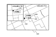
また、本発明の時系列地図を用いた履歴地図検索方法は、店舗が移転している場合にも、移転先を検索することができる。例えば、図12に示すように、A市AA町1丁目の「KK商店」の位置を検索しようとしたが、現在は「KK商店」はB市BB町4丁目に移転している。従来の地図検索では、A市AA町1丁目付近の地図において名称「KK商店」を検索しても、「KK商店」が存在した場所は「YY産業」1203になっているので、目的とする建物は見つけることはできない。 Moreover, the historical map search method using the time-series map of the present invention can search for a relocation destination even when a store is relocated. For example, as shown in FIG. 12, an attempt was made to search for the position of “KK store” in A city AA town 1-chome, but now “KK store” has moved to B city BB town 4 chome. In the conventional map search, even if the name “KK store” is searched in the map near A city A 1-cho, the place where “KK store” is located is “YY industry” 1203. The building cannot be found.
そこで、「KK商店」が移転した際、「KK商店」の属性データに移転先の代表点座標を格納しておく。過去に存在した「KK商店」が履歴検索によって検索された後、領域データベース102を参照して、移転先の代表点を包含する領域を検索し、検索された領域の地図を読み出して、代表点座標に対応する属性データを照合して、移転先の場所を特定する。
Therefore, when the “KK store” is moved, the representative point coordinates of the transfer destination are stored in the attribute data of “KK store”. After “KK store” existing in the past is searched by history search, the
さらに、過去の属性データを検索することによって、複数世代にわたって、移転先を追いかけることができる。 Furthermore, by searching for past attribute data, it is possible to follow the transfer destination for a plurality of generations.
これより、現存する「YY産業」1203と共に、過去に存在した「KK商店」1204も、画面1201に表示する。なお、検索対象である「KK商店」は四角で囲って強調して表示される。さらに、サブ画面1202が表示され、その中に現在の「KK商店」1205の場所が強調して表示される。
As a result, the existing “YY industry” 1203 and the “KK store” 1204 that existed in the past are also displayed on the
本発明の履歴地図検索は地表面の建物だけに限定されない。例えば、図13に示すように地下街地図1301にも、本発明の履歴地図検索を適用することができる。
The historical map search of the present invention is not limited to buildings on the ground surface. For example, as shown in FIG. 13, the historical map search of the present invention can also be applied to an
すなわち、テナントの名称を属性データに格納しておき、名称をキーとして属性データを検索することによって、代表点座標が見つかり、過去にその場所が存在したことがわかれば、テナントの存在を認識することができる。 In other words, by storing the tenant name in the attribute data and searching the attribute data using the name as a key, the representative point coordinates are found, and if the location exists in the past, the presence of the tenant is recognized. be able to.
例えば、予め作成されている地下街の地図を利用して、複数の異なる版の地図1301を持っているユーザがナビゲーションをする場合、過去に存在した「L書店」1303を待ち合わせ場所に指定しても、「L書店」1303は現在「F屋」1103になっているので、従来のナビゲーションでは「L書店」を見つけることはできない。しかし、本発明の履歴地図検索を用いることによって、図13に示すように過去に存在したテナントの「L書店」1303を検索することができる。
For example, when a user who has a plurality of different versions of the
なお、地下街はGPS衛星からの電波が届かないため、GPS以外の位置情報取得手段を、自分の位置座標の特定のために用いる必要がある。例えば、GPS以外の位置情報取得手段として、無線LANシステムやセンサネットシステムを用いて、電波発信源の近くを通過したときに、位置情報(地下内部での座標データ)を取得すればよい。 In addition, since the radio wave from the GPS satellite does not reach the underground shopping street, it is necessary to use position information acquisition means other than GPS for specifying its own position coordinates. For example, as position information acquisition means other than GPS, position information (coordinate data in the basement) may be acquired when a wireless LAN system or a sensor network system is used to pass near a radio wave source.
地下街では、建物の形状が変わることは少ないが、テナントの名称は頻繁に変化する。従って、履歴地図データ及び履歴属性データを検索することによって、過去に存在したテナントを確認することができる。 In underground malls, the shape of buildings rarely changes, but tenant names change frequently. Therefore, tenants that existed in the past can be confirmed by searching the history map data and history attribute data.
なお、履歴地図において管理される図形形状データ及び属性データは、現在と過去の図形形状データ及び属性データに限定する必要はない。例えば、将来の建物の図形形状データ及び属性データを、各々、地図データベース101及び属性データベース103に格納することによって、将来の時間においても検索することができる。具体的には、図形形状データ303、304及び属性データ305、306に、建設予定の建物の概略の形状、名称及び時間情報を登録すればよい。
The graphic shape data and attribute data managed in the history map need not be limited to current and past graphic shape data and attribute data. For example, by storing the graphic shape data and attribute data of the future building in the
これによって、過去、現在、将来も含めて、建物を検索することができる。 As a result, it is possible to search for buildings including the past, present, and future.
ここまで、図形形状データ及び属性データに時間情報を含めることによって、現在だけでなく、過去に存在した建物及び将来に存在する建物のデータの管理について説明した。しかし、時間変化情報が蓄積するとデータも大きくなり検索に時間がかかる。このため、図14に示す構成でデータを管理することによって、検索を効率化する。 Up to this point, management of data on buildings existing in the past and buildings in the future has been described by including time information in the graphic shape data and attribute data. However, if time change information is accumulated, the data becomes large and it takes time to search. Therefore, the search is made efficient by managing the data with the configuration shown in FIG.
図14に示す例では、地図データは所定の期間毎に分割された地図データテーブルに格納される。同様に、属性データは所定の期間毎に分割された属性データテーブルに格納される。例えば、図14に示すように、1970年〜1980年、1981年〜1990年、1991年〜2000年、2001年以降のように、データを分割することができる。そして、過去に遡って図形形状データ及び属性データを検索する場合、まず、最近(2001年以降)のデータから検索する。そして、検索対象のデータがその期間に存在しない場合、検索された期間と隣接する過去の期間(1991年〜2000年)に遡って検索をする。 In the example shown in FIG. 14, the map data is stored in a map data table divided every predetermined period. Similarly, the attribute data is stored in an attribute data table divided every predetermined period. For example, as shown in FIG. 14, the data can be divided as in 1970 to 1980, 1981 to 1990, 1991 to 2000, 2001 and thereafter. When searching for graphic shape data and attribute data going back to the past, first, the data is searched from the latest (2001 or later) data. If the search target data does not exist in that period, the search is performed retroactively to the past period (1991 to 2000) adjacent to the searched period.
また、図14は、地図データベース101に格納された地図データ及び属性データベース103に格納された属性データが、時間によって分割されている状態(1401、1402、1403、1404)を示す。この場合、複数の期間にわたって存在する図形形状データ及び属性データは、複数のデータテーブルに重複して格納される。
FIG. 14 shows a state (1401, 1402, 1403, 1404) in which the map data stored in the
図14に示す例では、前述した図2と異なり、時間管理部1406が新たに追加されている。時間管理部1406は、参照すべき地図データテーブル及び属性データテーブルの期間を管理する。そして、時空間目標照合部110から、検索未終了(検索したが、検索対象の図形形状データ及び属性データが検索されなかった状態)の信号1409が送られた場合に、時間管理部1406は、次に検索すべき過去の地図データテーブル及び属性データテーブルを指定して、地図検索部104及び時空間形状データ検索部106、さらに属性検索部113および時空間属性データ検索部111による検索範囲を指定する。これは前述したステップ714(図7参照)に相当する。
In the example illustrated in FIG. 14, a
また、属性を検索キーとして検索するのではなく、形状を検索キーとして検索することも考えられる。例えば、図15に示すように、概略の形状1506を入力して、その入力された形状と一致する形状を、過去に遡って検索する。検索キーとなる形状は、ペン入力等の方法によって、計算機の画面に直接入力する方法が採用できる。
It is also conceivable to search not using an attribute as a search key but using a shape as a search key. For example, as shown in FIG. 15, a
このような形状をキーとした検索は、特徴的な形状の建物が存在する場合に有効である。データのフォーマット及びデータ間の関係は、図4に示すものと同一のものを用いることができる。 A search using such a shape as a key is effective when a building having a characteristic shape exists. The same data format and relationship as shown in FIG. 4 can be used.
例えば、図15に示すように、検索キーとなる形状1506の入力を受け付ける。検索キーとなる形状には、二つの円形1503、1504及び一つの四角形1505が入力されている。そして、検索キーとなる形状1506は、一つの四角形と近接した二つの円形を含むことが、計算機によって判定できる。そこで、地図データを参照すると、現在の地図データには検索キーとなる形状と一致する図形形状データはないが(現在は形状1501である)、過去の地図データには検索キーとなる形状と一致する図形形状データが登録されている。この形状の照合には、一般的な公知のパターンマッチング技術を用いることができる。
For example, as shown in FIG. 15, an input of a
そして、検索された形状に代表点座標が含まれる属性データを検索し、名称「BBBビル」1502を探し出すことが可能となる。このように、履歴地図検索を用いることにより、過去に存在した建物の形状を照合することが可能となる。 Then, it is possible to search for attribute data whose representative point coordinates are included in the searched shape and search for the name “BBB building” 1502. Thus, by using the history map search, it becomes possible to collate the shapes of buildings that existed in the past.
このとき、現在の建物の形状データ1501(点線表示)、及びその名称「AAA社」を、過去の図形形状データ及び名称と重畳して表示することによって、建物やその属性が変更されていることを表示することができる。 At this time, the building and its attributes have been changed by displaying the current building shape data 1501 (dotted line display) and its name “AAA company” superimposed on the past graphic shape data and name. Can be displayed.
なお、一つの四角形と2個の円形状の存在期間が異なる場合であっても、検索することができる。具体的には、まず、円形状の形状キーとして過去の地図データを検索し、検索された円形に近接してもう一つの円形及び四角形が存在したかを、別の期間も検索範囲に含めて地図データを検索する。そして、存在期間が重複しなくても、検索キーとなる形状の一部が各期間で一致した場合に、検索ヒットとすることができる。 In addition, even when the existence periods of one square and two circles are different, the search can be performed. Specifically, first, past map data is searched as a circular shape key, and whether another circle and a rectangle exist in the vicinity of the searched circle is also included in the search range. Search map data. Even if the existence periods do not overlap, a search hit can be made when a part of the shape serving as a search key matches in each period.
地図は、最新の情報に更新されると、過去の情報が失われてしまう。しかし、以上説明した実施の形態によると、時間情報が付加されたデータを管理することによって、過去のデータを廃棄することなく、保持して、検索に利用できるようになる。 When the map is updated to the latest information, the past information is lost. However, according to the embodiment described above, by managing data to which time information is added, past data can be retained and used for searching without being discarded.
さらに、同じ場所が異なるテナントになっている場合でも、過去のテナント名を検索キーとして、過去に存在したテナントを検索することができる。 Furthermore, even if the same place is a different tenant, a past tenant can be searched using a past tenant name as a search key.
これによって、検索目標の名称(及び、その名称を有する建物)が現存しなくても、検索対象とする期間を指定することなく、過去に遡って検索が可能となる。また、異なる時間に存在した建物の属性データ(名称等)を用いて、ナビゲーション等の機能を実現することができる。 As a result, even if the name of the search target (and the building having the name) does not exist, the search can be performed retrospectively without specifying the period to be searched. In addition, functions such as navigation can be realized by using the attribute data (names, etc.) of buildings that exist at different times.
また、地図データと属性データの両方を用いて過去の建物を特定していくので、ある期間のデータが欠落していても、過去に遡って検索をすることができる。 In addition, since past buildings are specified using both map data and attribute data, even if data for a certain period is missing, it is possible to search retroactively.
さらに、検索対象の地理的範囲と属性データとを直接照合するのではなく、検索対象の地理的範囲と建物の形状データとを照合し、その後、建物の形状データと属性データの位置情報(代表点)とを照合する。このため、属性データの位置情報が検索対象の地理的範囲に含まれない場合でも、検索目標の属性データの検索が可能となる。例えば、建物が大きい場合には、代表点は建物の一端から離れた場所にある。本実施の形態によると、大きな建物の一部が地理的検索範囲と重なれば、建物とリンクされた代表点を検索することができる。 Furthermore, instead of directly matching the geographical area to be searched with the attribute data, the geographical area to be searched is matched with the shape data of the building, and then the position information of the building shape data and the attribute data (representative) Point). For this reason, even when the position information of the attribute data is not included in the geographical range to be searched, the search target attribute data can be searched. For example, if the building is large, the representative point is located away from one end of the building. According to this embodiment, if a part of a large building overlaps the geographical search range, a representative point linked to the building can be searched.
101 地図データベース
102 領域データベース
103 属性データベース
104 地図検索部
105 地図・属性データ出力部
106 時空間形状データ検索部
107 位置・名称情報読取部
108 地図座標変換部
109 時間リスト作成部
110 時空間目標物照合部
111 時空間属性データ検索部
112 変化物データ指示部
113 属性データ検索部
401 履歴地図サーバ
402 履歴属性サーバ
403 時空間検索サーバ
404 携帯端末(携帯電話機)
405 モバイルPC
406 サーバ計算機群
407 クライアント計算機群
405 Mobile PC
406
Claims (11)
プロセッサ、前記プロセッサに接続されるメモリ、前記プロセッサに接続される通信インターフェース、及び前記プロセッサに接続されるユーザインターフェースを備え、
検索対象の地理的範囲及び検索キーの入力を受け付ける情報取込部と、
前記入力された検索対象の地理的範囲と、前記形状データが表す範囲の少なくとも一部が重なる形状データを前記地図データから抽出する地図検索部と、
前記入力された検索キーと一致し、かつ前記抽出された形状データが表す範囲と前記位置情報が重なる属性データを、前記形状データ及び前記属性データに付された時間情報に従って、前記形状データと対応付ける対応付け部と、
前記対応付けられた形状データ及び属性データを出力する出力部と、を備え、
前記形状データ及び属性データに付された時間情報は、前記対象物が存在した又は存在予定の期間であって、
前記地図データは、複数の区画に区分されて格納されており、
前記地図検索部は、前記入力された検索対象の地理的範囲が含まれる地図データの区画を特定して、前記特定された区画において形状データを検索し、
前記対応付け部は、
前記形状データの検索範囲と前記位置情報が重なる属性データを抽出し、
前記抽出された形状データと属性データとを、前記属性データに付された位置情報を用いて照合し、
前記照合された形状データ及び属性データのうち、前記形状データ及び前記属性データに付された時間情報が重なるものを対応付け、
前記形状データと対応付けられた属性データから、前記入力された検索キーと一致するものを選択することを特徴とする地理情報システム。 A geographic information system that uses map data including shape data with time information, and attribute data with position information and time information that are attributes of an object included in the map data,
A processor, a memory connected to the processor, a communication interface connected to the processor, and a user interface connected to the processor;
An information capture unit that accepts input of a geographical range to be searched and a search key;
A map search unit that extracts from the map data shape data that overlaps at least a part of the input geographical range and the range represented by the shape data;
The attribute data that matches the input search key and that overlaps the position information and the range represented by the extracted shape data is associated with the shape data according to the time information attached to the shape data and the attribute data. An association unit;
An output unit that outputs the associated shape data and attribute data ,
The time information attached to the shape data and the attribute data is a period in which the object exists or is scheduled to exist,
The map data is stored divided into a plurality of sections,
The map search unit specifies a section of map data including the input geographical range to be searched, and searches for shape data in the specified section.
The association unit
Extract attribute data that overlaps the search range of the shape data and the position information,
The extracted shape data and attribute data are collated using position information attached to the attribute data,
Of the matched shape data and attribute data, associate the time data attached to the shape data and the attribute data,
Geographic information systems from the shape data and the associated attribute data, wherein you to select the one that matches the input search keys.
前記対応付け部は、前記代表点座標が前記形状データが表す範囲に含まれるかによって、前記形状データと前記属性データとを照合することを特徴とする請求項1に記載の地理情報システム。 The geographic information system according to claim 1, wherein the association unit collates the shape data with the attribute data depending on whether the representative point coordinates are included in a range represented by the shape data.
前記対応付けられた形状データ及び属性データのいずれも変化しない期間に対応するデータセットを作成し、前記作成されたデータセットが時間順に並べられた時間リストを作成し、 Create a data set corresponding to a period in which neither the associated shape data or attribute data changes, create a time list in which the created data sets are arranged in time order,
前記作成された時間リストから、前記入力された検索キーと一致する属性データを選択することを特徴とする請求項1に記載の地理情報システム。 2. The geographic information system according to claim 1, wherein attribute data matching the input search key is selected from the created time list.
前記対応付け部は、前記形状データと対応付けられた属性データの前記地図上の位置を特定し、 The association unit specifies a position on the map of attribute data associated with the shape data,
前記経路探索部は、前記位置が特定された属性データを用いて経路を探索し、 The route search unit searches for a route using the attribute data in which the position is specified,
前記出力部は、前記探索された経路を出力することを特徴とする請求項1に記載の地理情報システム。 The geographic information system according to claim 1, wherein the output unit outputs the searched route.
前記対応付け部は、前記入力された検索キーと属性データが一致する対象物の移転先の情報が、前記属性データに含まれている場合は、前記対象物の移転先の情報を取得し、 The associating unit obtains information on a destination of the object when the attribute data includes the information on the destination of the object whose attribute data matches the input search key,
前記出力部は、前記取得した情報を地図上に表示するためのデータを出力することを特徴とする請求項1に記載の地理情報システム。 The geographic information system according to claim 1, wherein the output unit outputs data for displaying the acquired information on a map.
前記対応付け部は、前記区分された前記地図データ及び前記属性データを、最新の期間のものから順に対応付けることを特徴とする請求項1に記載の地理情報システム。 The geographic information system according to claim 1, wherein the association unit associates the classified map data and the attribute data in order from the latest period.
前記対応付け部は、検索キーと属性データとの一致を判定することなく、前記抽出された形状データであって前記入力された形状と一致する形状の形状データと重なる属性データを、前記形状データ及び前記属性データに付された時間情報に従って、前記形状データと対応付けることを特徴とする請求項1に記載の地理情報システム。 The associating unit determines attribute data that overlaps shape data of the extracted shape data that matches the input shape without determining whether the search key matches the attribute data. The geographical information system according to claim 1, wherein the geographical information system is associated with the shape data according to time information attached to the attribute data.
第1プロセッサ、前記第1プロセッサに接続されるメモリ、及び前記第1プロセッサに接続される通信インターフェースを備えるサーバと、 A server comprising a first processor, a memory connected to the first processor, and a communication interface connected to the first processor;
第2プロセッサ、前記第2プロセッサに接続されるメモリ、前記第2プロセッサに接続される通信インターフェース、及び前記第2プロセッサに接続されるユーザインターフェースを備える端末と、を備え、 A second processor, a memory connected to the second processor, a communication interface connected to the second processor, and a terminal having a user interface connected to the second processor,
前記サーバは、前記地図検索部、前記対応付け部及び前記出力部を備え、 The server includes the map search unit, the association unit, and the output unit,
前記端末は、前記情報取込部、及び、前記出力部から出力されたデータを表示する表示部を備えることを特徴とする請求項1に記載の地理情報システム。 The geographic information system according to claim 1, wherein the terminal includes a display unit that displays the information capturing unit and data output from the output unit.
前記端末は、前記情報取込部、前記地図検索部、前記対応付け部、前記出力部、及び、前記出力部から出力されたデータを表示する表示部を備えることを特徴とする請求項1に記載の地理情報システム。 The said terminal is provided with the display part which displays the data output from the said information taking-in part, the said map search part, the said matching part, the said output part, and the said output part. The described geographic information system.
検索対象の地理的範囲及び検索キーの入力を受け付け、 Accepts the search scope and search key input,
前記入力された検索対象の地理的範囲と、前記形状データが表す範囲の少なくとも一部が重なる形状データを前記地図データから抽出し、 Extracting from the map data shape data that overlaps at least a part of the input geographical range and the range represented by the shape data;
前記入力された検索キーと一致し、かつ前記抽出された形状データが表す範囲と前記位置情報が重なる属性データを、前記形状データ及び前記属性データに付された時間情報に従って、前記形状データと対応付け、 Attribute data that matches the input search key and overlaps the position information and the range represented by the extracted shape data corresponds to the shape data according to the time information attached to the shape data and the attribute data. With
前記対応付けられた形状データ及び属性データを出力し、 Outputting the associated shape data and attribute data;
前記形状データ及び属性データに付された時間情報は、前記対象物が存在した又は存在予定の期間であって、 The time information attached to the shape data and the attribute data is a period in which the object exists or is scheduled to exist,
前記地図データは、複数の区画に区分されて格納されており、 The map data is stored divided into a plurality of sections,
前記形状データを抽出する手順では、前記入力された検索対象の地理的範囲が含まれる地図データの区画を特定して、前記特定された区画において形状データを検索し、 In the procedure of extracting the shape data, the section of the map data that includes the input geographical range to be searched is specified, and the shape data is searched in the specified section.
前記属性データを前記形状データと対応付ける手順では、 In the procedure for associating the attribute data with the shape data,
前記形状データの検索範囲と前記位置情報が重なる属性データを抽出し、 Extract attribute data that overlaps the search range of the shape data and the position information,
前記抽出された形状データと属性データとを、前記属性データに付された位置情報を用いて照合し、 The extracted shape data and attribute data are collated using position information attached to the attribute data,
前記照合された形状データ及び属性データのうち、前記形状データ及び前記属性データに付された時間情報が重なるものを対応付け、 Of the matched shape data and attribute data, associate the time data attached to the shape data and the attribute data,
前記形状データと対応付けられた属性データから、前記入力された検索キーと一致するものを選択することを特徴とする地理情報管理方法。 A geographic information management method comprising: selecting attribute data corresponding to the input search key from attribute data associated with the shape data.
Priority Applications (2)
| Application Number | Priority Date | Filing Date | Title |
|---|---|---|---|
| JP2007223789A JP4926891B2 (en) | 2007-08-30 | 2007-08-30 | Geographic information system and geographic information management method |
| US12/193,134 US8359324B2 (en) | 2007-08-30 | 2008-08-18 | Geographic information system |
Applications Claiming Priority (1)
| Application Number | Priority Date | Filing Date | Title |
|---|---|---|---|
| JP2007223789A JP4926891B2 (en) | 2007-08-30 | 2007-08-30 | Geographic information system and geographic information management method |
Publications (3)
| Publication Number | Publication Date |
|---|---|
| JP2009058252A JP2009058252A (en) | 2009-03-19 |
| JP2009058252A5 JP2009058252A5 (en) | 2010-04-02 |
| JP4926891B2 true JP4926891B2 (en) | 2012-05-09 |
Family
ID=40409038
Family Applications (1)
| Application Number | Title | Priority Date | Filing Date |
|---|---|---|---|
| JP2007223789A Active JP4926891B2 (en) | 2007-08-30 | 2007-08-30 | Geographic information system and geographic information management method |
Country Status (2)
| Country | Link |
|---|---|
| US (1) | US8359324B2 (en) |
| JP (1) | JP4926891B2 (en) |
Families Citing this family (30)
| Publication number | Priority date | Publication date | Assignee | Title |
|---|---|---|---|---|
| US8077918B2 (en) | 2008-08-28 | 2011-12-13 | Google, Inc. | Architectures and methods for creating and representing time-dependent imagery |
| US8872847B2 (en) | 2008-08-28 | 2014-10-28 | Google Inc. | Architectures and methods for creating and representing time-dependent imagery |
| CN101661461B (en) | 2008-08-29 | 2016-01-13 | 阿里巴巴集团控股有限公司 | Determine the method for core geographic information in document, system |
| US20100149036A1 (en) * | 2008-11-24 | 2010-06-17 | Craig Rosenberg | System and Methods for Using Current and Past Positional Data to Provide Advanced Spatial and Temporal Information and Unique Location Based Services |
| US8433296B2 (en) | 2009-05-01 | 2013-04-30 | Ryan Hardin | Exclusive delivery of content within geographic areas |
| JP5193969B2 (en) * | 2009-05-21 | 2013-05-08 | ヤフー株式会社 | Map display apparatus and method for simultaneously displaying different maps |
| JP2010286387A (en) * | 2009-06-12 | 2010-12-24 | Navitime Japan Co Ltd | Navigation apparatus, navigation system, terminal device, navigation server, and navigation method |
| US8633964B1 (en) * | 2009-12-04 | 2014-01-21 | Google Inc. | Generating video from panoramic images using transition trees |
| US9552669B2 (en) * | 2010-09-02 | 2017-01-24 | Underground Imaging Technologies, Llc | System, apparatus, and method for utilizing geographic information systems |
| NL2008690C2 (en) * | 2011-04-25 | 2014-07-15 | Google Inc | Dynamic highlighting of geographic entities on electronic maps. |
| US20130067379A1 (en) * | 2011-09-13 | 2013-03-14 | General Electric Company | Graphical comparison of geographic information system data |
| US20130132846A1 (en) * | 2011-11-21 | 2013-05-23 | Clover Point Cartographics Ltd | Multiple concurrent contributor mapping system and method |
| JP5721643B2 (en) * | 2012-01-30 | 2015-05-20 | 三菱電機株式会社 | Information search device and navigation device |
| US20130268540A1 (en) * | 2012-04-09 | 2013-10-10 | Luuk van Dijk | Biasing geocoding of queries |
| EP2717015B1 (en) * | 2012-10-08 | 2018-05-23 | Harman Becker Automotive Systems GmbH | Seamless display of objects |
| JP5596770B2 (en) * | 2012-11-28 | 2014-09-24 | 株式会社ナビタイムジャパン | Navigation device, navigation system, terminal device, navigation server, navigation method, and program |
| JP6053510B2 (en) * | 2012-12-27 | 2016-12-27 | 株式会社ゼンリンデータコム | Base search device, base search method and base search program |
| US9081796B2 (en) * | 2013-01-09 | 2015-07-14 | Raytheon Company | Methods and apparatuses for providing and displaying cluster data |
| US9466140B2 (en) * | 2013-10-18 | 2016-10-11 | eQuisition, LLC. | System and method for making a map |
| US9934222B2 (en) | 2014-04-22 | 2018-04-03 | Google Llc | Providing a thumbnail image that follows a main image |
| USD781318S1 (en) | 2014-04-22 | 2017-03-14 | Google Inc. | Display screen with graphical user interface or portion thereof |
| USD781317S1 (en) | 2014-04-22 | 2017-03-14 | Google Inc. | Display screen with graphical user interface or portion thereof |
| US9972121B2 (en) * | 2014-04-22 | 2018-05-15 | Google Llc | Selecting time-distributed panoramic images for display |
| USD780777S1 (en) | 2014-04-22 | 2017-03-07 | Google Inc. | Display screen with graphical user interface or portion thereof |
| CN104240134B (en) * | 2014-09-04 | 2018-01-09 | 中联重机股份有限公司 | Machinery farmer method and system based on farmland situation |
| US10671648B2 (en) * | 2016-02-22 | 2020-06-02 | Eagle View Technologies, Inc. | Integrated centralized property database systems and methods |
| RU2755871C2 (en) * | 2017-06-13 | 2021-09-22 | Ниссан Мотор Ко., Лтд. | Method and device for storing cartographic data |
| CN110109917A (en) * | 2018-02-01 | 2019-08-09 | 董福田 | A kind of processing method and processing device of data |
| JP6817385B1 (en) * | 2019-07-25 | 2021-01-20 | エヌ・ティ・ティ・インフラネット株式会社 | Map information sharing device, map information sharing method, map information sharing program |
| US11593411B2 (en) | 2019-09-13 | 2023-02-28 | International Business Machines Corporation | Historical augmentation of electronic maps |
Family Cites Families (21)
| Publication number | Priority date | Publication date | Assignee | Title |
|---|---|---|---|---|
| JP4044971B2 (en) * | 1994-03-17 | 2008-02-06 | 株式会社日立製作所 | Search method using image information |
| JP2849577B2 (en) * | 1995-09-29 | 1999-01-20 | アイシン・エィ・ダブリュ株式会社 | House shape information output device, house shape information output method, map display device, map display method, navigation device, and navigation method |
| US5767795A (en) * | 1996-07-03 | 1998-06-16 | Delta Information Systems, Inc. | GPS-based information system for vehicles |
| JP3703297B2 (en) * | 1998-04-27 | 2005-10-05 | 株式会社日立製作所 | Geographic information data management method |
| JP4187324B2 (en) * | 1998-10-01 | 2008-11-26 | 松下電器産業株式会社 | Car navigation system |
| JP2000347563A (en) * | 1999-06-02 | 2000-12-15 | Matsushita Electric Ind Co Ltd | Geographical information processor |
| JP2003529832A (en) * | 2000-03-23 | 2003-10-07 | ザ ジョンズ ホプキンズ ユニバーシティ | Biomonitoring detection and warning methods and systems |
| JP4097913B2 (en) * | 2001-05-18 | 2008-06-11 | 三菱電機株式会社 | Navigation device |
| JP2002156899A (en) * | 2001-07-24 | 2002-05-31 | Equos Research Co Ltd | Map display device and recording medium |
| JP4093296B2 (en) | 2001-11-19 | 2008-06-04 | 財団法人新産業創造研究機構 | A spatio-temporal information system with a temporal element added to the spatial information data structure and its program |
| US6731239B2 (en) * | 2002-01-18 | 2004-05-04 | Ford Motor Company | System and method for retrieving information using position coordinates |
| US20030200192A1 (en) * | 2002-04-18 | 2003-10-23 | Bell Brian L. | Method of organizing information into topical, temporal, and location associations for organizing, selecting, and distributing information |
| JP4047061B2 (en) * | 2002-05-09 | 2008-02-13 | 株式会社ゼンリン | Data structure of a map database that stores multiple records in time series |
| US7162405B2 (en) * | 2002-05-31 | 2007-01-09 | Certalogic, Inc. | Method for modeling and viewing real world objects in a network model at real world times |
| US7091970B2 (en) * | 2002-08-21 | 2006-08-15 | International Business Machines Corporation | Mapping display space |
| JP4232697B2 (en) * | 2004-06-24 | 2009-03-04 | 株式会社デンソー | Car navigation system |
| JP2006092513A (en) * | 2004-08-25 | 2006-04-06 | Denso Corp | Item search device |
| JP4604866B2 (en) * | 2005-06-16 | 2011-01-05 | 株式会社デンソー | Facility search device |
| US20070233375A1 (en) * | 2006-03-31 | 2007-10-04 | Ashutosh Garg | Providing advertising in aerial imagery |
| US8872847B2 (en) * | 2008-08-28 | 2014-10-28 | Google Inc. | Architectures and methods for creating and representing time-dependent imagery |
| US8077918B2 (en) * | 2008-08-28 | 2011-12-13 | Google, Inc. | Architectures and methods for creating and representing time-dependent imagery |
-
2007
- 2007-08-30 JP JP2007223789A patent/JP4926891B2/en active Active
-
2008
- 2008-08-18 US US12/193,134 patent/US8359324B2/en active Active
Also Published As
| Publication number | Publication date |
|---|---|
| US8359324B2 (en) | 2013-01-22 |
| JP2009058252A (en) | 2009-03-19 |
| US20090063424A1 (en) | 2009-03-05 |
Similar Documents
| Publication | Publication Date | Title |
|---|---|---|
| JP4926891B2 (en) | Geographic information system and geographic information management method | |
| JP4408622B2 (en) | Data collection system and method for geographic database | |
| US7076741B2 (en) | Point-of-interest icon and point-of-interest mark display method | |
| CN105051735B (en) | Sensor data collection | |
| US9843893B2 (en) | Method and apparatus for providing point-of-interest detection via feature analysis and mobile device position information | |
| US8706693B2 (en) | Map update data delivery method, map update data delivery device and terminal device | |
| US8176045B2 (en) | Systems and methods for cross-street identification | |
| JP2015055633A (en) | Technology for modifying digitalized map data | |
| JP2007226688A (en) | Position search apparatus, position search method and program | |
| JP2008217612A (en) | Sensor data control system and sensor data control method | |
| JP2008191075A (en) | Position specifying method for deformation map, position specifying system for the deformation map, position specifying method for measurement map, and position specifying system for measurement map | |
| JP5234339B2 (en) | Computer system and route guidance method | |
| CN103390099A (en) | Service system and service method based on mobile operation system platform and Mobile GIS (Geographic Information System) | |
| CN1726407A (en) | Providing a user with location-based information | |
| JP2003207358A (en) | Road guidance unit and program | |
| JP5749057B2 (en) | Navigation device | |
| CN108763414B (en) | Live-action display method and device, terminal equipment and storage medium | |
| JP2010086485A (en) | Method and system for conversion from residence indication number to registered lot number | |
| JP6898121B2 (en) | Map registration system, map registration method, information processing device | |
| JP2009282693A (en) | Registration information acquisition method and registration information acquisition system | |
| JP7274406B2 (en) | Baggage information registration device and program | |
| JP6812282B2 (en) | Map registration system, map registration method | |
| JP2004177862A (en) | Map location correction apparatus and method | |
| JP7345075B1 (en) | People flow data management system and people flow data management method | |
| JP2004125871A (en) | Apparatus, system, method, and program for preparing simple map |
Legal Events
| Date | Code | Title | Description |
|---|---|---|---|
| A521 | Written amendment |
Free format text: JAPANESE INTERMEDIATE CODE: A523 Effective date: 20100217 |
|
| A621 | Written request for application examination |
Free format text: JAPANESE INTERMEDIATE CODE: A621 Effective date: 20100217 |
|
| A977 | Report on retrieval |
Free format text: JAPANESE INTERMEDIATE CODE: A971007 Effective date: 20110824 |
|
| A131 | Notification of reasons for refusal |
Free format text: JAPANESE INTERMEDIATE CODE: A131 Effective date: 20110830 |
|
| A521 | Written amendment |
Free format text: JAPANESE INTERMEDIATE CODE: A523 Effective date: 20111026 |
|
| TRDD | Decision of grant or rejection written | ||
| A01 | Written decision to grant a patent or to grant a registration (utility model) |
Free format text: JAPANESE INTERMEDIATE CODE: A01 Effective date: 20120110 |
|
| A01 | Written decision to grant a patent or to grant a registration (utility model) |
Free format text: JAPANESE INTERMEDIATE CODE: A01 |
|
| A61 | First payment of annual fees (during grant procedure) |
Free format text: JAPANESE INTERMEDIATE CODE: A61 Effective date: 20120208 |
|
| FPAY | Renewal fee payment (event date is renewal date of database) |
Free format text: PAYMENT UNTIL: 20150217 Year of fee payment: 3 |
|
| R150 | Certificate of patent or registration of utility model |
Ref document number: 4926891 Country of ref document: JP Free format text: JAPANESE INTERMEDIATE CODE: R150 Free format text: JAPANESE INTERMEDIATE CODE: R150 |