JP4732465B2 - Workstation with display that can change scale - Google Patents
Workstation with display that can change scale Download PDFInfo
- Publication number
- JP4732465B2 JP4732465B2 JP2007548878A JP2007548878A JP4732465B2 JP 4732465 B2 JP4732465 B2 JP 4732465B2 JP 2007548878 A JP2007548878 A JP 2007548878A JP 2007548878 A JP2007548878 A JP 2007548878A JP 4732465 B2 JP4732465 B2 JP 4732465B2
- Authority
- JP
- Japan
- Prior art keywords
- map
- size
- symbol
- symbols
- background
- Prior art date
- Legal status (The legal status is an assumption and is not a legal conclusion. Google has not performed a legal analysis and makes no representation as to the accuracy of the status listed.)
- Expired - Fee Related
Links
Images


Classifications
-
- G—PHYSICS
- G06—COMPUTING; CALCULATING OR COUNTING
- G06F—ELECTRIC DIGITAL DATA PROCESSING
- G06F3/00—Input arrangements for transferring data to be processed into a form capable of being handled by the computer; Output arrangements for transferring data from processing unit to output unit, e.g. interface arrangements
- G06F3/01—Input arrangements or combined input and output arrangements for interaction between user and computer
- G06F3/048—Interaction techniques based on graphical user interfaces [GUI]
- G06F3/0481—Interaction techniques based on graphical user interfaces [GUI] based on specific properties of the displayed interaction object or a metaphor-based environment, e.g. interaction with desktop elements like windows or icons, or assisted by a cursor's changing behaviour or appearance
-
- G—PHYSICS
- G06—COMPUTING; CALCULATING OR COUNTING
- G06F—ELECTRIC DIGITAL DATA PROCESSING
- G06F3/00—Input arrangements for transferring data to be processed into a form capable of being handled by the computer; Output arrangements for transferring data from processing unit to output unit, e.g. interface arrangements
- G06F3/01—Input arrangements or combined input and output arrangements for interaction between user and computer
- G06F3/048—Interaction techniques based on graphical user interfaces [GUI]
- G06F3/0484—Interaction techniques based on graphical user interfaces [GUI] for the control of specific functions or operations, e.g. selecting or manipulating an object, an image or a displayed text element, setting a parameter value or selecting a range
- G06F3/04847—Interaction techniques to control parameter settings, e.g. interaction with sliders or dials
-
- G—PHYSICS
- G06—COMPUTING; CALCULATING OR COUNTING
- G06F—ELECTRIC DIGITAL DATA PROCESSING
- G06F2203/00—Indexing scheme relating to G06F3/00 - G06F3/048
- G06F2203/048—Indexing scheme relating to G06F3/048
- G06F2203/04806—Zoom, i.e. interaction techniques or interactors for controlling the zooming operation
Abstract
Description
本発明は、背景と背景に分散された一組のシンボルとを含む少なくとも1つのマップを表示するためのユニットと、ユーザがマップの見え方を選択することを可能にするためのインタフェースと、選択インタフェースを用いてユーザによって行われる見え方の選択に応じて、マップの見え方を変更するために表示ユニットを制御するための制御手段とを含むタイプのワークステーションに関する。 The present invention includes a unit for displaying at least one map including a background and a set of symbols distributed in the background, an interface for allowing a user to select how the map is to be viewed, and selection The present invention relates to a workstation of the type including control means for controlling the display unit to change the appearance of the map in response to the appearance selection made by the user using the interface.
マップが表示されることを可能にする多くのワークステーションは、すでに表示されているマップの小さな地帯を拡大することによって、または反対に、はじめに表示されたマップの一部分に関連した視点を拡大することによって、マップのスケールを変更するための手段を含む。そのような手段は通常、「ズーム」機能の提供と呼ばれている。 Many workstations that allow a map to be displayed can zoom in on a small area of the map that is already displayed, or vice versa, to expand the perspective associated with a portion of the map that was initially displayed. Includes means for changing the scale of the map. Such means are usually referred to as providing a “zoom” function.
前記手段は、特に移動遠距離通信ネットワークを最適化するためのワークステーションで、とりわけ便利である。最適化手段によって表示されるマップはその後、例えば様々なネットワークの基地局に関連したセルとともに、地域に設置された無線放送手段を提供する。 Said means are particularly convenient especially at workstations for optimizing mobile telecommunications networks. The map displayed by the optimization means then provides, for example, radio broadcasting means installed in the area, with cells associated with the base stations of the various networks.
実際にはマップは、地上の移動遠距離通信要素の位置に対応する正確な位置で背景に分散されたシンボルとともに、地上の地勢を描く背景から成り立っている。 In practice, the map consists of a background depicting the terrain on the ground, with symbols distributed in the background at precise locations corresponding to the location of mobile telecommunications elements on the ground.
一例として、シンボルは十字形、円形、正方形、三角形などの単純な幾何学的形状によって、またはそうした単純な形状の組合せによって、または実際に、丸、三角形、四角形の輪郭の中に含まれた文字または頭字語によって形成されることが可能である。 As an example, a symbol is a character that is contained in a simple geometric shape such as a cross, circle, square, triangle, etc., or a combination of such simple shapes, or in fact, within the outline of a circle, triangle, square Or it can be formed by an acronym.
ワークステーションに表示されるマップのスケールを変更する場合、ワークステーションはまた、表示されるシンボルのサイズと、シンボルが現れるマップの背景のスケールとが対応する方法で変更されるようにもする。 When changing the scale of the map displayed on the workstation, the workstation also ensures that the size of the displayed symbol and the scale of the map background in which the symbol appears are changed in a corresponding manner.
したがって、マップのスケールが小さい場合、背景に示されるシンボルは非常に小さく、特定の環境下では、それらは互いに区別されることができない。オペレータがシンボルを含むマップの領域を拡大することによって、シンボルをよりはっきりと識別しようとする場合、確かにシンボルはよりはっきりと見えるようになるが、ワークステーションによって表示されるマップの一部は非常に小さく、拡大されたシンボルのごく近くの周囲に制限される。特に移動電話ネットワークを構成するためにワークステーションを使用するオペレータは、ネットワークの非常に小さな一部しか示されないことから、そのとき非常に苦労させられる。 Thus, when the map scale is small, the symbols shown in the background are very small and under certain circumstances they cannot be distinguished from each other. If the operator wants to identify the symbols more clearly by enlarging the area of the map that contains the symbols, the symbols will certainly appear more clearly, but the part of the map displayed by the workstation is very Limited to the immediate vicinity of the small and enlarged symbols. In particular, operators who use workstations to configure a mobile telephone network are then very struggling because only a very small portion of the network is shown.
したがって本発明の目的は、局所的にマップを拡大するために現在ワークステーションに提供されている手段の欠点に対する解決法を提案することであり、この解決法はマップの大きな範囲を見えるようにしながら、見易さを改善するために役立つ。 The object of the present invention is therefore to propose a solution to the drawbacks of the means currently offered to workstations to locally enlarge the map, while this solution makes a large range of maps visible. Help to improve visibility.
このために本発明は、前記インタフェースが少なくとも1つのシンボルのサイズだけを選択するための手段を含み、制御手段が、マップの背景のスケールを変更することなく、表示ユニットが選択されたサイズに応じて、シンボルまたは各シンボル(the or each symbol)のサイズを変更するように構成されていることを特徴とする、上で指定されたタイプのワークステーションを提供する。 To this end, the present invention includes means for the interface to select only the size of at least one symbol, and the control means responds to the selected size of the display unit without changing the scale of the map background. Providing a workstation of the type specified above, characterized in that it is configured to change the size of the symbols or the or each symbol.
特定の実施形態で、ワークステーションは以下の特徴のうちの1つまたは複数を含む。
・シンボルはタイプによって分散され、インタフェースは各タイプのシンボルのために別々にサイズを選択するための手段を含み、制御手段は、マップの背景のスケールを変更することなく、表示ユニットがそのシンボルタイプのために選択されたサイズに応じて、所与のシンボルタイプのすべてのシンボルのサイズを変更するように構成されている。
・シンボルまたは各シンボルは、同じ見え方と異なる寸法とを有する一組のピクセルマトリックスに関連しており、制御手段は、選択されたサイズに応じてピクセルマトリックスのうちの1つを表示するために、表示ユニットを制御するように構成されている。
・前記インタフェースは、マップの領域を選択するための手段と、前記選択された領域に分散されたシンボルのサイズを変更することなく、選択されたマップの領域の背景のスケールを変更するための手段とを含む。
・選択手段は、シンボルまたは各シンボルのサイズが所定のステップで選択されることを可能にするために適している。
In certain embodiments, the workstation includes one or more of the following features.
The symbols are distributed by type, the interface includes means for selecting the size separately for each type of symbol and the control means allows the display unit to change its symbol type without changing the scale of the map background Depending on the size selected for, it is configured to resize all symbols of a given symbol type.
The symbol or each symbol is associated with a set of pixel matrices having the same appearance and different dimensions, the control means for displaying one of the pixel matrices according to the selected size The display unit is configured to be controlled.
The interface comprises means for selecting an area of the map and means for changing the scale of the background of the area of the selected map without changing the size of the symbols distributed in the selected area; Including.
The selection means is suitable for allowing a symbol or the size of each symbol to be selected in a given step.
本発明は、単に一例として示されており、添付の図面を参照する以下の説明を読むことで、より良く理解されることが可能である。 The invention is shown by way of example only and can be better understood by reading the following description with reference to the accompanying drawings.
図1に示されているワークステーション10は、移動電話ネットワークを調査し、最適化するためのものである。
The
ワークステーションはそれ自体で知られている方法で、調査中の移動電話ネットワークを表すマップを表示するように構成されたソフトウェアを実行する。 The workstation executes software configured to display a map representing the mobile telephone network under investigation in a manner known per se.
したがってステーションは、情報を処理するための中央ユニット12と、表示スクリーン14と、スクリーン14に表示されたグラフィックインタフェース19から機能が選択されることを可能にするキーボード16および/またはマウス18などのマン/マシンインタフェースを形成する手段とを含む。インタフェースは、特に表示の見え方を変更する目的でグラフィック機能が選択されることを可能にするために適している。
Thus, the station may be a man unit, such as a
情報プロセッサユニット12は、キーボード16および/またはマウス18から受信された情報に基づいて、データを処理し、スクリーン14上の表示を制御するコンピュータプログラムが実行されることを可能にするプロセッサ20を備える。
The
さらにユニット12は、マップの描写、およびワークステーションによって実行されるプログラムを記憶するために役立つ、ハードディスクなどのデータ記憶手段22を含む。
The
プログラムは特に、マップ全体か、またはマップの小さい地帯のスケールを大きくしたものをスクリーン14に表示するために適している。
The program is particularly suitable for displaying on the
このためにマップは、表示手段14上のマップの描写とマップの見え方との両方で、背景24と背景に分散された一組のシンボル26とを有する。
For this purpose, the map has a
背景24は、例えば陸、海、河川、交通路(travel corridors)、市街地、および特定の行政または工業区画を区別する、マップの範囲上の地形の3次元の形状に対応する。
The
背景に分散されているシンボル26の各々は、地上に実際に存在しているネットワーク要素に対応する。シンボルは、地上のそれらの実際の位置に対応する位置で、背景に配置される。
Each
例えば、各シンボルは幾何学的形状の形態、および/または幾何学的形状と、背景のシンボルに対応する位置で地上に存在する要素のタイプを指定する頭字語との組合せの形態をとる。 For example, each symbol may take the form of a geometric shape and / or a combination of a geometric shape and an acronym that specifies the type of element present on the ground at a location corresponding to the background symbol.
したがって複数のタイプのシンボルは、例えば移動電話ネットワークの基地局、固定ネットワークへの接続ポイント、交換局、または任意のその他のネットワーク対象物を指定するために事前に定義される。 Thus, multiple types of symbols are predefined to specify, for example, a base station of a mobile telephone network, an attachment point to a fixed network, a switching center, or any other network object.
各タイプのネットワーク要素のために、所与のシンボルは複数のサイズの一組のピクセルマトリックスに関連付けられる。これらのマトリックスは記憶手段22の中に記憶される。したがって任意の特定のタイプのシンボルは、例えば4×4、8×8、12×12、16×16、24×24、32×32、48×48および64×64ピクセルの寸法を有するマトリックスの形態で記憶されてもよい。 For each type of network element, a given symbol is associated with a set of pixel matrices of multiple sizes. These matrices are stored in the storage means 22. Thus, any particular type of symbol may be in the form of a matrix having dimensions of, for example, 4 × 4, 8 × 8, 12 × 12, 16 × 16, 24 × 24, 32 × 32, 48 × 48 and 64 × 64 pixels. May be stored.
プログラムの制御下で動作するワークステーションのプロセッサ20は、選択インタフェース16、18および19からユーザによって行われる選択に応じて、マップの見え方を変更する目的で、表示ユニット14を制御するための手段を構成する。
A
したがって図1に示されているように、知られている方法でマップ全体がスクリーン14に表示される場合、制御手段は、例えば4×4ピクセルのマトリックスなどの非常に小さいサイズのシンボル26によってネットワーク要素が表されることを確実にする。
Thus, as shown in FIG. 1, when the entire map is displayed on the
さらに選択手段は、マップ上の定められた地帯を、前記地帯のスケールを変更する目的で選択する可能性を含む。このスケールの変更は、選択された地帯が、マップによって先に占められていた地帯をスクリーン14上で占めるというものである。したがって表示されるマップは、スケールの変更によって実行される拡大を用いて、表示制御手段によって拡大される。
Furthermore, the selection means includes a possibility of selecting a predetermined zone on the map for the purpose of changing the scale of the zone. The change in scale is that the selected zone occupies on the
一例として、および知られている方法で、拡大されるべき地帯は、拡大されるべき地帯をカバーするためにマウス18を用いてスクリーン上を動かされるボックス19Aによって選択される。
As an example, and in a known manner, the zone to be magnified is selected by a
第1の実施態様では、知られている方法で、ネットワーク要素は図1に示されているように、マップのスケールの変更と同じ比率で拡大されたサイズのシンボルによって、拡大された画像上に表される。 In a first embodiment, in a known manner, the network elements are placed on the magnified image with symbols sized at the same rate as the scale change of the map, as shown in FIG. expressed.
しがたって、最初のマップの4分の1だけが選択されるのであれば、スケールは2倍にされることが可能であり、最初に4×4ピクセルであったシンボルは、その後8×8ピクセルのシンボルによって表されるようになる。 Thus, if only a quarter of the first map is selected, the scale can be doubled, and the symbol that was originally 4 × 4 pixels is then 8 × 8 It is represented by a pixel symbol.
第2の実施態様では、本発明によって、図2に示されているようにマップの背景だけが拡大され、背景に分散されたシンボルはそれらの最初のサイズで維持される。 In a second embodiment, the present invention enlarges only the map background, as shown in FIG. 2, and maintains the symbols distributed in the background at their initial size.
さらに表示手段は、ユーザがキーボード14またはマウス16を用いて各タイプのシンボルの新たなサイズを個別に選択できるようにするグラフィックインタフェース19をユーザが利用できるようにする。
In addition, the display means makes available to the user a
そのようなインタフェース19の例は、図3に示されている。この図の中で、丸で囲まれた文字からなるシンボルとして示されている各タイプのネットワーク要素は、「+」ボタンと「−」ボタンとに関連付けられており、ユーザがマウスを用いてボタンのうちの1つの上にポインタを動かして、次いでスクリーン上のそのタイプのシンボルの表示サイズを大きくするか(+ボタン)、または反対に小さくする(−ボタン)ことを可能にする。
An example of such an
インタフェースはシンボルのタイプによってサイズが選択されることを可能にするので、拡大、縮小、およびユーザによって選択されるサイズで変更されるべきシンボルのタイプを用いて、重要な特定のタイプのシンボルが拡大される一方で、あまり使用しないその他のものが縮小されることを可能にする。 The interface allows the size to be selected according to the type of symbol, so that the particular type of symbol that is important will be expanded using the type of symbol to be scaled, scaled, and changed by the size selected by the user On the other hand, others that do not use very much can be reduced.
したがって、「+」または「−」のマークを付けられたボタンのうちの1つか、または他方のものの上で動作を行うことによって、表示ユニット14は、マップの背景のスケールを変更することなく、および当該シンボルを動かすことなく、起動されるボタンに関連したタイプのマップ上に存在するすべてのシンボルのサイズを変更する。
Thus, by performing an action on one of the buttons marked “+” or “−” or on the other, the
シンボルサイズの変更は所定のステップで行われ、すなわち、シンボルを表示するために使用されるピクセルマトリックスは、「+」ボタンが押される場合には次に大きい記憶されたマトリックスによって、または「−」ボタンが押される場合には次に小さい記憶されたマトリックスによって置き換えられる。したがって、例えば表示されたシンボルが8×8ピクセルのマトリックスによって形成されている場合、その後そのシンボルは、対応する12×12ピクセルのマトリックスを表示することによって拡大されるか、または4×4ピクセルのマトリックスを表示することによって縮小される。 The symbol size change is done in a predetermined step, i.e. the pixel matrix used to display the symbol is either the next largest stored matrix if the "+" button is pressed or "-". If the button is pressed, it is replaced by the next smaller stored matrix. Thus, for example, if the displayed symbol is formed by an 8 × 8 pixel matrix, the symbol is then enlarged by displaying a corresponding 12 × 12 pixel matrix, or 4 × 4 pixel It is reduced by displaying the matrix.
ステップの中でのこのサイズの変化は、サイズを表す数値をユーザが入力するいかなる必要性も回避する。 This change in size during the step avoids any need for the user to enter a numerical value representing the size.
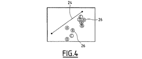
図4に示されているように、マップの背景のスケールのいかなる変更も伴わずにシンボルのサイズを大きくすることは、ユーザが様々なシンボルをよりはっきりと見ることができるようにするので、マップの領域の一部を見失うことなく、シンボルを互いに区別し、一方でこれらの様々なシンボルの間の正しい距離を維持する。 As shown in FIG. 4, increasing the size of a symbol without any change in the scale of the map background allows the user to see different symbols more clearly, so that the map The symbols are distinguished from each other without losing sight of some of the regions, while maintaining the correct distance between these various symbols.
マップの背景のスケールの変更と背景に存在するシンボルのサイズの変更との間の非相関性のために、移動電話ネットワークの構成と改良とは、そのようなワークステーションを用いてより簡単になるということが理解されることができる。ユーザによって必要とされる情報に応じて、ユーザは、マップの背景の一部のロスにつながることなく、使用するシンボルがはっきりと現れるようにすることができるので、シンボルによって表されるネットワークの様々な要素の間の距離の判断を継続することができる。 Due to the decorrelation between changing the scale of the map background and changing the size of the symbols present in the background, the configuration and improvement of the mobile telephone network becomes easier with such a workstation. It can be understood that. Depending on the information required by the user, the user can ensure that the symbols they use appear clearly without leading to the loss of part of the map background, so that the variety of networks represented by the symbols The determination of the distance between the various elements can be continued.
Claims (4)
ユーザがマップの見え方を選択することを可能にするための選択インタフェース(16、18、19、19A)と、
前記選択インタフェース(16、18、19、19A)を用いてユーザによって行われる見え方の選択に応じて、マップの見え方を変更するために表示ユニット(14)を制御するための制御手段(20)とを備えるワークステーション(10)であって、
前記選択インタフェースが1つのシンボルのサイズを選択する手段(19)を含み、
制御手段(20)が、マップの背景の縮尺を変更することなく、表示ユニット(14)が選択されたサイズに応じて、各シンボルのサイズを変更するように構成されており、
シンボルがタイプによって分類されていることと、選択インタフェース(19)がシンボルのタイプ毎に別々にサイズを選択する手段を含むことと、制御手段(20)が、マップの背景の縮尺を変更することなく、表示ユニット(14)が所与のシンボルタイプのすべてのシンボルのサイズを、そのシンボルタイプのために選択されたサイズに応じて変更するように構成されていることとを特徴とする、ワークステーション(10)。And the background, the including a plurality of symbols distributed on the background, a unit for displaying at least one map (14),
A selection interface (16, 18, 19, 19A) to allow the user to select how the map looks;
Depending on the choice of appearance made by the user using the selected interface (16,18,19,19A), control means for controlling the display unit to change the appearance of the map (14) (20 A workstation (10) comprising:
It said selection interface comprises a hand stage (19) that select the size of one symbol,
The control means (20) is configured to change the size of each symbol according to the selected size of the display unit (14) without changing the scale of the map background .
That the symbols are classified by type, the selection interface (19) includes means for selecting the size separately for each type of symbol, and the control means (20) changes the scale of the map background. And the display unit (14) is configured to change the size of all symbols of a given symbol type according to the size selected for that symbol type. Station (10).
Applications Claiming Priority (3)
| Application Number | Priority Date | Filing Date | Title |
|---|---|---|---|
| FR0453274 | 2004-12-31 | ||
| FR0453274A FR2880439B1 (en) | 2004-12-31 | 2004-12-31 | WORKSTATION WITH VARIABLE SCALE DISPLAY |
| PCT/FR2005/051126 WO2006072725A2 (en) | 2004-12-31 | 2005-12-22 | Workstation with variable-scale display |
Publications (2)
| Publication Number | Publication Date |
|---|---|
| JP2008527480A JP2008527480A (en) | 2008-07-24 |
| JP4732465B2 true JP4732465B2 (en) | 2011-07-27 |
Family
ID=34952184
Family Applications (1)
| Application Number | Title | Priority Date | Filing Date |
|---|---|---|---|
| JP2007548878A Expired - Fee Related JP4732465B2 (en) | 2004-12-31 | 2005-12-22 | Workstation with display that can change scale |
Country Status (8)
| Country | Link |
|---|---|
| US (1) | US20080013792A1 (en) |
| EP (1) | EP1677179B1 (en) |
| JP (1) | JP4732465B2 (en) |
| CN (1) | CN101111742B (en) |
| AT (1) | ATE459861T1 (en) |
| DE (1) | DE602005019678D1 (en) |
| FR (1) | FR2880439B1 (en) |
| WO (1) | WO2006072725A2 (en) |
Families Citing this family (4)
| Publication number | Priority date | Publication date | Assignee | Title |
|---|---|---|---|---|
| US9141345B2 (en) * | 2010-01-27 | 2015-09-22 | Microsoft Technology Licensing, Llc | Simplified user controls for authoring workflows |
| US9717478B2 (en) * | 2010-12-27 | 2017-08-01 | St. Jude Medical, Atrial Fibrillation Division, Inc. | Refinement of an anatomical model using ultrasound |
| US10431122B2 (en) * | 2015-02-25 | 2019-10-01 | Environmental Systems Research Institute (ESRI) | Systems and methods for smart cartography |
| US11175157B1 (en) * | 2018-10-24 | 2021-11-16 | Palantir Technologies Inc. | Dynamic scaling of geospatial data on maps |
Citations (8)
| Publication number | Priority date | Publication date | Assignee | Title |
|---|---|---|---|---|
| JPS61261772A (en) * | 1985-05-16 | 1986-11-19 | 株式会社デンソー | Map display unit |
| JPH07168524A (en) * | 1994-08-23 | 1995-07-04 | Zanabui Informatics:Kk | Navigation device |
| JPH07175409A (en) * | 1994-08-23 | 1995-07-14 | Zanabui Informatics:Kk | Display method of map for navigation device |
| JPH0883331A (en) * | 1994-09-13 | 1996-03-26 | Sharp Corp | Picture processor |
| JPH08146870A (en) * | 1994-11-22 | 1996-06-07 | Hitachi Ltd | Display method and device for navigation |
| JPH09171435A (en) * | 1996-11-21 | 1997-06-30 | Casio Comput Co Ltd | Character display device and recording medium |
| JPH09237039A (en) * | 1996-02-29 | 1997-09-09 | Fujitsu Ten Ltd | Navigation device |
| JPH10153438A (en) * | 1996-11-25 | 1998-06-09 | Sumitomo Electric Ind Ltd | Navigation device |
Family Cites Families (14)
| Publication number | Priority date | Publication date | Assignee | Title |
|---|---|---|---|---|
| CA2097232C (en) * | 1993-05-28 | 1999-01-19 | Phillip J. Beaudet | Displaying partial graphs by expanding and collapsing nodes |
| US5596691A (en) * | 1994-06-15 | 1997-01-21 | Claris Corporation | Computer system and method for manipulating the display of drawings |
| JP3781795B2 (en) * | 1995-01-20 | 2006-05-31 | 三菱電機株式会社 | Mobile navigation device |
| US6459430B1 (en) * | 1999-02-17 | 2002-10-01 | Conexant Systems, Inc. | System and method for implementing multi-level resolution conversion using modified linear interpolation |
| US6426761B1 (en) * | 1999-04-23 | 2002-07-30 | Internation Business Machines Corporation | Information presentation system for a graphical user interface |
| FR2793935B1 (en) * | 1999-05-21 | 2001-08-17 | Isweb | METHOD FOR VIEWING GEOGRAPHICAL SITES |
| DE19941945C2 (en) * | 1999-09-03 | 2003-07-10 | Volkswagen Ag | Method and device for displaying activated operating and display areas |
| US7142196B1 (en) * | 1999-10-12 | 2006-11-28 | Autodesk, Inc. | Geographical data markup on a personal digital assistant (PDA) |
| WO2001061445A2 (en) * | 2000-02-18 | 2001-08-23 | Psion Infomedia Limited | Media player receiving entertainment content from several sources |
| US6853375B2 (en) * | 2000-05-10 | 2005-02-08 | Cognos Incorporated | Method for preemptive screen rendering |
| US20020023000A1 (en) * | 2000-08-16 | 2002-02-21 | Bollay Denison W. | Displaying as a map and graphs on a web page the geographical distribution of visitors that click on banner ads in cyberspace |
| US7170528B1 (en) * | 2002-10-23 | 2007-01-30 | Bentley Systems, Inc. | Fast glyph rendering for vector based fonts |
| US7215337B2 (en) * | 2003-12-18 | 2007-05-08 | Palo Alto Research Center Incorporated | Systems and methods for the estimation of user interest in graph theoretic structures |
| US7487442B2 (en) * | 2004-12-20 | 2009-02-03 | Microsoft Corporation | Method, system, and computer-readable medium for the layout of automatically-placed elements and user-placed elements in a chart |
-
2004
- 2004-12-31 FR FR0453274A patent/FR2880439B1/en not_active Expired - Fee Related
-
2005
- 2005-12-21 AT AT05112672T patent/ATE459861T1/en not_active IP Right Cessation
- 2005-12-21 EP EP05112672A patent/EP1677179B1/en not_active Not-in-force
- 2005-12-21 DE DE602005019678T patent/DE602005019678D1/en active Active
- 2005-12-22 US US11/813,193 patent/US20080013792A1/en not_active Abandoned
- 2005-12-22 WO PCT/FR2005/051126 patent/WO2006072725A2/en active Application Filing
- 2005-12-22 CN CN2005800474365A patent/CN101111742B/en not_active Expired - Fee Related
- 2005-12-22 JP JP2007548878A patent/JP4732465B2/en not_active Expired - Fee Related
Patent Citations (8)
| Publication number | Priority date | Publication date | Assignee | Title |
|---|---|---|---|---|
| JPS61261772A (en) * | 1985-05-16 | 1986-11-19 | 株式会社デンソー | Map display unit |
| JPH07168524A (en) * | 1994-08-23 | 1995-07-04 | Zanabui Informatics:Kk | Navigation device |
| JPH07175409A (en) * | 1994-08-23 | 1995-07-14 | Zanabui Informatics:Kk | Display method of map for navigation device |
| JPH0883331A (en) * | 1994-09-13 | 1996-03-26 | Sharp Corp | Picture processor |
| JPH08146870A (en) * | 1994-11-22 | 1996-06-07 | Hitachi Ltd | Display method and device for navigation |
| JPH09237039A (en) * | 1996-02-29 | 1997-09-09 | Fujitsu Ten Ltd | Navigation device |
| JPH09171435A (en) * | 1996-11-21 | 1997-06-30 | Casio Comput Co Ltd | Character display device and recording medium |
| JPH10153438A (en) * | 1996-11-25 | 1998-06-09 | Sumitomo Electric Ind Ltd | Navigation device |
Also Published As
| Publication number | Publication date |
|---|---|
| WO2006072725A2 (en) | 2006-07-13 |
| WO2006072725A3 (en) | 2007-02-08 |
| FR2880439A1 (en) | 2006-07-07 |
| ATE459861T1 (en) | 2010-03-15 |
| JP2008527480A (en) | 2008-07-24 |
| US20080013792A1 (en) | 2008-01-17 |
| CN101111742A (en) | 2008-01-23 |
| DE602005019678D1 (en) | 2010-04-15 |
| EP1677179B1 (en) | 2010-03-03 |
| EP1677179A3 (en) | 2007-01-10 |
| CN101111742B (en) | 2011-11-16 |
| FR2880439B1 (en) | 2007-04-27 |
| EP1677179A2 (en) | 2006-07-05 |
Similar Documents
| Publication | Publication Date | Title |
|---|---|---|
| US9153210B2 (en) | Method of graphically indicating on a wireless communications device that map data is still being downloaded | |
| RU2393525C2 (en) | Improved key-based navigation facilities | |
| US5357603A (en) | Method and system for changing a shape type while maintaining existing graphic characteristics | |
| JP3598303B2 (en) | Method of selectively displaying and activating overlapping display objects on a display, and computer system | |
| US8508549B2 (en) | User-interface design | |
| US7907146B2 (en) | Resolution independent user interface design | |
| EP0403125A2 (en) | Zoom mode operations in display apparatus | |
| JP2003337041A (en) | Map display system, method for displaying map and program | |
| US20170285910A1 (en) | Method and mobile communication terminal for changing a configuration of a screen displaying function items | |
| US20040141008A1 (en) | Positioning of areas displayed on a user interface | |
| JP4732465B2 (en) | Workstation with display that can change scale | |
| CN112100408B (en) | Historical entity data display method, device and equipment | |
| JP2010073206A (en) | Visual graphical display of number of remaining characters in edit field of electronic device | |
| GB2284524A (en) | Graphic editing apparatus and method | |
| JP2005267049A (en) | Portable information apparatus, and its control method and program | |
| CN106445276A (en) | Desktop icon processing method and apparatus | |
| US8250480B2 (en) | Interactive navigation of a dataflow process image | |
| US8645857B2 (en) | Method for controlling information display | |
| US20140176423A1 (en) | Seat layout display apparatus, seat layout display method, and program thereof | |
| CN104992108A (en) | Password setting method and device | |
| JP5193969B2 (en) | Map display apparatus and method for simultaneously displaying different maps | |
| JP4275928B2 (en) | MAP DISPLAY DEVICE, MAP DISPLAY METHOD, PROGRAM, AND RECORDING MEDIUM | |
| US11373256B2 (en) | Editing and representing property values for a digital map | |
| JPH09167071A (en) | Device and method for automatic editing of display menu | |
| JPH1069362A (en) | Method and device for automatically changing character display size |
Legal Events
| Date | Code | Title | Description |
|---|---|---|---|
| A977 | Report on retrieval |
Free format text: JAPANESE INTERMEDIATE CODE: A971007 Effective date: 20100415 |
|
| A131 | Notification of reasons for refusal |
Free format text: JAPANESE INTERMEDIATE CODE: A131 Effective date: 20100427 |
|
| A601 | Written request for extension of time |
Free format text: JAPANESE INTERMEDIATE CODE: A601 Effective date: 20100715 |
|
| A602 | Written permission of extension of time |
Free format text: JAPANESE INTERMEDIATE CODE: A602 Effective date: 20100723 |
|
| A521 | Request for written amendment filed |
Free format text: JAPANESE INTERMEDIATE CODE: A523 Effective date: 20101026 |
|
| TRDD | Decision of grant or rejection written | ||
| A01 | Written decision to grant a patent or to grant a registration (utility model) |
Free format text: JAPANESE INTERMEDIATE CODE: A01 Effective date: 20110412 |
|
| A01 | Written decision to grant a patent or to grant a registration (utility model) |
Free format text: JAPANESE INTERMEDIATE CODE: A01 |
|
| A61 | First payment of annual fees (during grant procedure) |
Free format text: JAPANESE INTERMEDIATE CODE: A61 Effective date: 20110420 |
|
| FPAY | Renewal fee payment (event date is renewal date of database) |
Free format text: PAYMENT UNTIL: 20140428 Year of fee payment: 3 |
|
| R150 | Certificate of patent or registration of utility model |
Free format text: JAPANESE INTERMEDIATE CODE: R150 |
|
| R250 | Receipt of annual fees |
Free format text: JAPANESE INTERMEDIATE CODE: R250 |
|
| R250 | Receipt of annual fees |
Free format text: JAPANESE INTERMEDIATE CODE: R250 |
|
| R250 | Receipt of annual fees |
Free format text: JAPANESE INTERMEDIATE CODE: R250 |
|
| R250 | Receipt of annual fees |
Free format text: JAPANESE INTERMEDIATE CODE: R250 |
|
| LAPS | Cancellation because of no payment of annual fees |