JP4358440B2 - Acting on source data for route determination in navigation systems - Google Patents
Acting on source data for route determination in navigation systems Download PDFInfo
- Publication number
- JP4358440B2 JP4358440B2 JP2000558357A JP2000558357A JP4358440B2 JP 4358440 B2 JP4358440 B2 JP 4358440B2 JP 2000558357 A JP2000558357 A JP 2000558357A JP 2000558357 A JP2000558357 A JP 2000558357A JP 4358440 B2 JP4358440 B2 JP 4358440B2
- Authority
- JP
- Japan
- Prior art keywords
- route
- data
- weight
- database
- edge
- Prior art date
- Legal status (The legal status is an assumption and is not a legal conclusion. Google has not performed a legal analysis and makes no representation as to the accuracy of the status listed.)
- Expired - Fee Related
Links
Images


Classifications
-
- G—PHYSICS
- G08—SIGNALLING
- G08G—TRAFFIC CONTROL SYSTEMS
- G08G1/00—Traffic control systems for road vehicles
- G08G1/09—Arrangements for giving variable traffic instructions
- G08G1/0962—Arrangements for giving variable traffic instructions having an indicator mounted inside the vehicle, e.g. giving voice messages
- G08G1/0968—Systems involving transmission of navigation instructions to the vehicle
- G08G1/096805—Systems involving transmission of navigation instructions to the vehicle where the transmitted instructions are used to compute a route
- G08G1/096827—Systems involving transmission of navigation instructions to the vehicle where the transmitted instructions are used to compute a route where the route is computed onboard
-
- G—PHYSICS
- G01—MEASURING; TESTING
- G01C—MEASURING DISTANCES, LEVELS OR BEARINGS; SURVEYING; NAVIGATION; GYROSCOPIC INSTRUMENTS; PHOTOGRAMMETRY OR VIDEOGRAMMETRY
- G01C21/00—Navigation; Navigational instruments not provided for in groups G01C1/00 - G01C19/00
- G01C21/26—Navigation; Navigational instruments not provided for in groups G01C1/00 - G01C19/00 specially adapted for navigation in a road network
- G01C21/34—Route searching; Route guidance
- G01C21/3453—Special cost functions, i.e. other than distance or default speed limit of road segments
-
- G—PHYSICS
- G08—SIGNALLING
- G08G—TRAFFIC CONTROL SYSTEMS
- G08G1/00—Traffic control systems for road vehicles
- G08G1/09—Arrangements for giving variable traffic instructions
- G08G1/0962—Arrangements for giving variable traffic instructions having an indicator mounted inside the vehicle, e.g. giving voice messages
- G08G1/0968—Systems involving transmission of navigation instructions to the vehicle
- G08G1/096833—Systems involving transmission of navigation instructions to the vehicle where different aspects are considered when computing the route
- G08G1/09685—Systems involving transmission of navigation instructions to the vehicle where different aspects are considered when computing the route where the complete route is computed only once and not updated
Landscapes
- Engineering & Computer Science (AREA)
- Radar, Positioning & Navigation (AREA)
- Remote Sensing (AREA)
- Physics & Mathematics (AREA)
- General Physics & Mathematics (AREA)
- Automation & Control Theory (AREA)
- Mathematical Physics (AREA)
- Navigation (AREA)
- Traffic Control Systems (AREA)
Description
【0001】
発明の属する技術分野
本発明は、ディジタルデータベースに基づき移動手段たとえば車両、航空機または船舶のために、まえもって定められたスタートポイントからまえもって定められたターゲットポイントまでのルートを決定するためのソースデータに作用を与える請求項1の上位概念に記載の方法に関する。この場合、前記ディジタルデータベースは、まえもって定められた経路区間ki を、それら個々の経路区間ki を相互に結ぶ相応に割り当てられたノードポイントni とともに有しており、前記の経路区間ki および/またはノード区間ni に個々のウェイトgi が割り当てられている。
【0002】
たとえばGPS(Global Positioning System)をベースとするようなナビゲーションシステムは、まえもって定められた目的地までのナビゲーションにあたり、移動手段の運転者を支援する。この場合、ナビゲーションシステムは、少なくとも出発地座標と目的地座標ならびに実際の道路網のコピーである相応のディジタルデータベースに基づき、最適な経路もしくは最適なルートを決定する。しかしながら、自立的に求められたナビゲーションシステムのルートであると、これまでのナビゲーションシステムの場合には実際の交通事象たとえば特定の道路区間での渋滞などが考慮されず、または不十分にしか考慮されない。
【0003】
発明の開示、課題、解決手段、利点
本発明の課題は、冒頭で述べた形式の方法において、上述の欠点を解消し、実際の交通状況で生じたそのような交通事象の作用を、適切なやり方でディジタルマップベースに簡単に変換するよう改良することにある。
【0004】
この課題は、冒頭で述べた形式の方法において請求項1または請求項2記載の特徴により解決される。
【0005】
さらに本発明によれば、ウェイトgi を外部の事象に依存して変更してから、ルート探索アルゴリズムによりルートを決定するように構成されている。
【0006】
これにより得られる利点とは、たとえばルート探索アルゴリズムにより最適な経路を見つけ出す際、設けられているディジタルマップベースに作用が及ぼされた後に代案ルートが生じ、それは基礎を成す交通状況を非常に正確に考慮したものとなる。
【0007】
請求項2から9には本発明の有利な実施形態が示されている。
【0008】
この場合、ウェイトgi の合計が最小となるようルート探索アルゴリズムによってルートを決定することにより、最適なルートガイドが実現される。
【0009】
本発明による方法の有利な実施形態によれば、ウェイトgi は、個々の経路区間ki の経路長li、個々の経路区間ki の走行時間tki および/または個々のノードポイントni における個々の待ち時間tni である。その際、ノードポイントはたとえば国境通過地点または料金所であり、待ち時間は個々の手続完了時間に関係する。
【0010】
好適には、ウェイトgi を変更するためのデータをデータソースが供給し、そのデータをデータシンクにおいて処理する。その際、データソースは、交通メッセージ用の受信機、イベントデータバンクおよび/またはデータベースに交通メッセージをマッピングするデータバンクであり、データシンクは、たとえばナビゲーションシステムにおけるナビゲーションコンピュータ内で交通メッセージデータを処理するソフトウェアである。
【0011】
事象に即してウェイトを変更するため、データソースおよび/またはまえもって定められたウェイト変更のためのデータシンクにより外部の事象を分類する。
【0012】
1つの有利な実施形態によれば、ウェイトgi は経路区間ki の走行時間tkiであり、変更されたウェイトtki neuは式
【0013】
【数3】

に従って得られ、ここでV(ki)は経路区間ki での速度であり、ΔVc は外部の事象に基づく経路区間速度の変更である。
【0015】
別の有利な実施形態によれば、ウェイトgi は経路区間ki の走行時間であり、データベースは階層的に構成されていて、変更されるウェイトtki neuは式
【0016】
【数4】
に従い得られ、ここでV(ki)は経路区間ki での速度であり、ΔVc は外部の事象に基づく経路区間速度の変更であり、ΔlLevelj は全エッジ長のパーセントで表した長さ配分であり、この長さの配分によって、階層状のデータベースの縮尺単純化レベルjにおける配分に応じた作用が表される。
【0018】
図面の簡単な説明
次に、添付の図面を参照しながら本発明について詳しく説明する。
【0019】
図1は、実際の道路網をマッピングするディジタルデータベースを示す図である。
【0020】
図2は、経路区間もしくはエッジとディジタルデータベースの経路区間ウェイトもしくはエッジウェイトとの対応関係を示す図である。
【0021】
図3は、ディジタルデータベースに基づく自動車のためのルートの実例を示す図であって、この場合、個々の走行時間がエッジのウェイトとして割り当てられている。
【0022】
図4は、ディジタルデータベースの階層構造を示す図である。
【0023】
図5は、交通事象の分類を示す図である。
【0024】
図6は、図3によるディジタルデータベースに基づく自動車のためのルートの実例を示す図である。
【0025】
図7は、変更されたウェイトを階層データベースにおける1つの縮尺単純化レベルから次のレベルへ一貫して受け渡す様子を示す図である。
【0026】
本発明を実施するための最良のやり方
次に、本発明による方法の動作説明のため、図1〜図4を参照しながら、ディジタル形式のデータベースないしはマップベースによる実際の道路網のマッピング、ならびにルート探索アルゴリズムによるその方法について詳しく説明する。
【0027】
ディジタルマップベースによる実際の道路網のマッピングは、たとえば図1に示されている形態をもつ。このように道路網は、数学的に簡単に2分グラフによって表される。そこにおいて道路の通りは、方向づけられた経路区間またはネットエッジ(ki)によってシンボリックに表される。ネットノード(ni)によって、道路要素相互間の結合(交差点、高速道路ジャンクション等)が表される。これらの属性を用いることで、このようなネットに関して経路記述を生成することができる。エッジの名前やその方向(エッジベクトル)に関して1つの経路はエッジリストのかたちで、規定されたスタートエレメントから出発して設定されたターゲットエレメントまで、一義的に規定される。
【0028】
ネット内のエッジに特定の属性(エッジウェイト)を割り当てる場合にはそのようなネットに対し、目下の車両位置(スタートエッジ)から出発して所望の目的地(ターゲットエッジ)まで、最適なルートを決定するアルゴリズム手法を適用することができる。この場合、エッジに割り当てられたウェイトは、様々な種類のものである。アルゴリズムにとって重要であるのは、データベースのすべてのエッジからアルゴリズムによって使用されたウェイトを取り出せることである。この課題を解決する公知の手法は、たとえば Ford または Moore による最適化アルゴリズムである。最も簡単な事例では、たとえば個々のエッジのエッジウェイトとして、図2の表に示されているように、それらの固有の長さを割り当てることができる。
【0029】
ついでこのようなネットに固有のルートサーチアルゴリズムが適用される。この目的は、見つけ出された選択に対し、「関与しているすべてのエッジウェイトの合計が、スタートエッジからターゲットエッジに至る決定可能な他のどのようなエッジ選択よりも小さい」ことがあてはまるよう、エッジ選択を決めることである。したがってこの手法によって、スタートエッジとターゲットエッジとの間の可能な最短接続が求められ、これは図1の実例では以下のとおりとなる:
k1 -> -k5 -> k8 -> -k10
ここで極性符号は、所定のエッジベクトルに関する走行方向を表す(正の極性符号:ベクトル方向;負の極性符号:反ベクトル方向)。
【0030】
エッジの属性づけのため、ウェイトとして他の解釈も可能である。走行時間に関して最適な経路を求めるため、たとえばウェイトとしてマップに走行時間を割り当てることができる。それらの走行時間は、エッジ長と区間要素(図3)において車両のとっている速度とから得られる。上述の記載において用いられたルート探索アルゴリズムは図3の実例であれば、25秒の最小総走行時間をもつ最適なルート K1 -> -k5 -> k6 を見つけ出す。
【0031】
次に図4を参照しながら、ディジタル形式のマップベースもしくはデータベースの構造について説明する。ディジタル形式のデータベースの規模ならびに計算技術的に制限された自立的ナビゲーションシステムの性能ゆえに一般に、そのようなデータベース(たとえばドイツ)を全体的にルート探索アルゴリズムによって用いることはできず、好適には種々の領域に分割される。このため、様々な分解能によって道路網を記述する複数のレベルへの分割を行うことができる(図4)。そのような部分領域の重要な特性は、それらがグラフエレメントの個数においてまえもって定められたオーダを超えない、ということである。このため道路マップのいっそう高い分解能のレベルには、相応に多くの部分領域が含まれる。
【0032】
この場合、階層状のディジタルデータベースの構造ならびに使用法を、地図帳形式の構造と似たものとして思い浮かべることができる。データベースによってカバーされる領域は、最も高い分解能では個々のページにおいて複数の部分領域に分割される。隣り合うページへの参照は、各ページ間の関係によって形成される。しかしながら一般的にユーザやアルゴリズム手法にとっては、1つのページまたは制限された個数のページしか同時に処理できない。このため、かなり遠い距離に及ぶルートを求めるためには、概要マップの形式でさらに縮尺単純化された表示が必要とされる(ディジタルデータベースの縮尺単純化されたレベル)。
【0033】
本発明による方法によれば、前述のグラフ(データベースと呼ぶ)における個々のエレメントのウェイトを、交通事象に依存して適切に変更することができる。この場合、操作すべきウェイトがグラフ中でエッジウェイトとして表されるのか、および/またはノードウェイトとして表されるのかは、重要ではない。以下では実例としてエッジウェイトについて説明するが、本発明はそれに限定されるものではない。たとえば交通事象の処理によって、エッジウェイトが変更される。エッジウェイトにマッピングされる他のどのような作用であっても、本発明による方法によって処理することができる。
【0034】
一貫したウェイト変更のために必要とされるすべてのデータは、少なくとも1つのデータソースへ完全に供給される。データシンクは、データソースから供給されたデータをデータベース内のデータと結びつける。データソースはたとえば交通メッセージの受信機、イベントデータバンクおよび/またはデータベースへ交通メッセージをマッピングするデータバンクであり、その際、作用を与えるべきデータベースエレメントを求めるやり方は、本発明による方法とは無関係である。データシンクはたとえば、ナビゲーションシステムのナビゲーションコンピュータにおいて交通メッセージデータを処理するソフトウェアである。
【0035】
あるグラフエレメントのウェイトを変更するため、ウェイト変更のソースと処理を行うシンクとの間のウェイト変更のフォームに関する取り決めが設けられている。このような取り決めは、たとえば事象の分類である。この場合、受信機は、定められたルールに従い交通メッセージに識別子をつける。ナビゲーションにおいて識別子に、規定されたウェイト変更を割り当てる。しかし本発明による方法によれば、メッセージ自体によってウェイト変更を規定することも可能である。その場合には、交通メッセージの送信側によってウェイト変更が指定される。ナビゲーション内には、ウェイト変更のためのデータは記憶されていない。
【0036】
本発明による方法を適用するために、関連するすべての事象が様々な事象クラスに格付けされる。その際、ある事象クラスはたとえば、目下の速度に対する所定の作用に相当し、図5に実例として示されているように、その作用はディジタルマップベース内の各エッジエレメントに割り当てられている。
【0037】
次に特別な実施例として、走行時間属性をもつエッジを重みづけるための計算式について詳しく説明する。スタートエッジとターゲットエッジとの間の所要走行時間に関して最適な経路を求めるため、図2に示した対応づけと同様に、ウェイトとしてエッジに個々の走行時間が割り当てられる。この場合、あるエッジの走行時間tki は、エッジ長lki とその区間エレメントに対してとられている走行速度V(ki)から、
【0038】
【数5】
となる。
【0040】
ここで関数V(ki)は目下のエッジエレメントに対し、固有のエッジ属性(たとえば機能的な道路クラス、国の帰属等)に依存して速度が割り当てられる。
【0041】
この場合、エッジの重み付けに対し、速度によって以下のように作用が及ぼされる。分類された交通事象は、とられている速度V(ki)の直線的な変更によりエッジエレメントki に対し作用が及ぼされる:
【0042】
【数6】
この場合、ΔVc は、エッジもしくは経路区間ki における外部の事象に基づく速度変更である。このようにして目下のネット全体において、すべての他のエッジエレメントはルート探索アルゴリズムにとってその「魅力」に関して、作用を受けたエレメントよりも良好なかたちで現れる。作用を受けたネットにそれを適用した場合、エッジエレメントはそれらの新たなウェイトに基づき評価され、個々のエレメントに適切な強さで作用が及ぼされれば、従来のやり方で得られるようなものに対して代案となるエッジ列もしくは分岐ルートまたは代案ルートが得られる。
【0044】
図3の実例のネットにおいてルート探索アルゴリズムが、スタートエッジとターゲットエッジに関して時間的に最短の経路についての最適な結果として、25秒の全走行時間をもつエッジ列 k1 -> -k5 -> k6 を求めたものとする。エッジエレメントk5に対し渋滞など十分に強い作用が及ぼされると、そのエッジウェイトは図5に従って10秒〜50秒に変更される:
【0045】
【数7】
このようして時間的に最適な経路を新たに計算した後、図6に示されているように、30秒の総走行時間をもつ択一的なエッジ列 k1 -> -k2 -> -k3 -> k6 が生じる。
【0047】
次に、階層状のデータモデルにおける一貫したエッジウェイト変更について詳しく説明する。分類された交通事象に関する先に説明したエッジウェイトに作用を及ぼす方法は、はじめはもっぱら一定のネットレベル内でエッジウェイトの変更を行う。これにより、ネット全体においてただ1つの縮尺単純化レベルにおいてのみ行われる(ディジタルデータベースの階層構造の描かれた図4参照)。ルート計算のためのアルゴリズムにとって、任意の縮尺単純化レベルからのデータを使用できなければならないため、好適には外部からのネット制御により変更されたエッジウェイトコンフィグレーションが、異なる縮尺単純化の他のあらゆるレベルにおいても行われる。この場合、特定のレベルで行われた変更は、他のすべてのレベルにおいて等価もしくは首尾一貫している。
【0048】
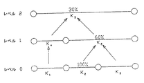
図7には、種々の縮尺単純化レベルにおける特定のネット区間が示されている。この場合、縮尺単純化レベルの番号が大きくなるにつれて、ディジタルマップベースもしくはデータベースにおけるそのネットマッピングのネット分解能が粗くなる。その際、実例として示されている最低縮尺単純化レベルの3つのエッジエレメントk1,k2,k3 は、最高縮尺単純化レベルではただ1つのエッジエレメントk6 によって表されている。ここで、エッジエレメントk2 に対し(式(II)に従い)分類されたある事象のマッピングによって、この最低縮尺レベルにおいてエレメントがその長さについて100%に設定されるある特定のエッジウェイト変更が引き起こされると、そのような作用はそれよりも高いレベルでは、(縮尺単純化に基づき)設けられているマッピング規則にのみ応じて、長さの配分に影響を及ぼすことができる。次に高い縮尺単純化レベルにおけるエレメントk5 も、作用を受けていないレベル0のエレメントk3 を表しており、その結果、エッジウェイト変更のためにレベル1でも、エッジk2 について相応の長さの配分だけしか変更できない。
【0049】
このように、作用を及ぼすべきエッジエレメントについて付加的な属性が必要とされ、それは個々のエレメントの該当する長さの配分を設けられている縮尺単純化レベルに依存して記述するものである。したがって式(II)で記述したエッジウェイト変更のための規則は、好適には対応する係数について以下のように拡張される:
【0050】
【数8】
ここでΔlLevelj は全エッジ長のパーセントで表した長さの配分であり、これは縮尺単純化レベルjにおいて配分に応じた作用を表す。
【0052】
このように本発明による方法によれば、まえもって定められた固定的なディジタルマップベースにおいて、スタティックに設定されたエッジウェイトおよび/またはノードウェイトに汎用的な作用を及ぼすことができるようになる。考慮すべき事象は、データベースに左右されずに設定可能な影響(事象分類)を用いてそれらに作用を及ぼすので、種々の影響を想定することができる。たとえば渋滞やのろのろ運転などの交通事象によって、特定の区間が悪化する可能性がある。この場合、自立的ナビゲーションシステムは、悪化したウェイトに応じてそのような区間(たとえば高速道路における渋滞)を避け、たとえば一般国道区間を経由した迂回が可能ならば、時間的に好適な方の選択肢を指示する。
【0053】
さらに別の可能な構成として、ある特定の属性に対応する所定のネット内における特定の区間が完全に閉鎖される。たとえば重たい貨物搬送車などの車両に対し、そのようなダイナミックなナビゲーションシステムは、最大走行重量が小さすぎる区間を閉鎖することができる。それ相応に悪化させたノードウェイトによって、そのような区間はルート探索アルゴリズムにとって通行不能というようにはたらき、したがって生成された走行推奨に関してそれ相応に迂回が行われる。
【0054】
他方、たとえば特定のルートをまえもって作り出し、システムによって提案されたルートに対しそのようにして適切なやり方で影響を与える目的で、ネット内のエッジウェイトの改善を行うことも考えられる。
【0055】
本発明による方法によれば、階層状のデータモデルにおいて首尾一貫した作用を確実に与えることができる。たとえばルート探索や目的地ガイドのためのこれまで基礎としてきたアルゴリズムをそのために整合させる必要はない。それというのも、それらにとって外部からの影響はわからないからである。
【図面の簡単な説明】
【図1】 実際の道路網をマッピングするディジタルデータベースを示す図である。
【図2】 経路区間もしくはエッジとディジタルデータベースの経路区間ウェイトもしくはエッジウェイトとの対応関係を示す図である。
【図3】 ディジタルデータベースに基づく自動車のためのルートの実例を示す図であって、この場合、個々の走行時間がエッジのウェイトとして割り当てられている。
【図4】 ディジタルデータベースの階層構造を示す図である。
【図5】 交通事象の分類を示す図である。
【図6】 図3によるディジタルデータベースに基づく自動車のためのルートの実例を示す図である。
【図7】 変更されたウェイトを階層データベースにおける1つの縮尺単純化レベルから次のレベルへ一貫して受け渡す様子を示す図である。[0001]
The present invention operates on source data for determining a route from a pre-determined start point to a pre-determined target point for a mobile means such as a vehicle, aircraft or ship based on a digital database. The method according to the superordinate concept of
[0002]
For example, a navigation system based on GPS (Global Positioning System) assists the driver of the moving means when navigating to a predetermined destination. In this case, the navigation system determines the optimum route or route based on at least the starting point coordinates and the destination coordinates and a corresponding digital database that is a copy of the actual road network. However, if the navigation system route is determined autonomously, in the case of conventional navigation systems, actual traffic events such as traffic congestion on a specific road section are not taken into account, or only insufficiently taken into account. .
[0003]
DISCLOSURE, PROBLEMS, SOLUTIONS AND ADVANTAGES OF THE INVENTION The object of the present invention is to solve the above-mentioned drawbacks in a method of the type described at the outset, and to appropriately describe the action of such traffic events that occur in actual traffic situations. There is an improvement to easily convert to a digital map base in a way.
[0004]
This problem is solved by the features of
[0005]
Further according to the present invention, change depending weights g i to external events, is configured to determine a route by route search algorithm.
[0006]
The advantage is that, for example, when finding an optimal route by a route search algorithm, an alternative route is created after acting on the provided digital map base, which makes the underlying traffic situation very accurate. It will be taken into consideration.
[0007]
[0008]
In this case, an optimum route guide is realized by determining the route by the route search algorithm so that the sum of the weights g i is minimized.
[0009]
According to an advantageous embodiment of the method according to the invention, weight g i is the path length of the individual route sections k i l i, the running times of the individual route block k i t ki and / or individual nodes point n i Is the individual waiting time t ni . In this case, the node point is, for example, a border crossing point or a toll gate, and the waiting time is related to the completion time of each procedure.
[0010]
Preferably, data supplied to the data source to modify the weights g i, and processes the data in the data sink. The data source is then a data bank that maps the traffic message to a receiver for traffic messages, an event data bank and / or a database, and the data sink processes the traffic message data, for example in a navigation computer in a navigation system. Software.
[0011]
In order to change the weight according to the event, the external event is classified by the data source and / or the data sink for the predetermined weight change.
[0012]
According to one advantageous embodiment, the weight g i is the travel time t ki of the route section k i and the modified weight t ki neu is of the formula
[Equation 3]
Where V (k i ) is the speed in the path segment k i and ΔV c is the change in path segment speed based on an external event.
[0015]
According to another advantageous embodiment, the weight g i is the travel time of the route section k i , the database is organized hierarchically, and the weight t ki neu to be changed is given by the formula
[Expression 4]
Where V (k i ) is the speed in the path interval k i , ΔV c is the change in path interval speed based on an external event, and Δl Levelj is the length expressed as a percentage of the total edge length. The distribution according to the length represents the action corresponding to the distribution at the scale simplification level j of the hierarchical database.
[0018]
BRIEF DESCRIPTION OF THE DRAWINGS The invention will now be described in detail with reference to the accompanying drawings.
[0019]
FIG. 1 is a diagram showing a digital database for mapping an actual road network.
[0020]
FIG. 2 is a diagram showing a correspondence relationship between a route section or edge and a route section weight or edge weight in the digital database.
[0021]
FIG. 3 is a diagram showing an example of a route for an automobile based on a digital database. In this case, individual travel times are assigned as edge weights.
[0022]
FIG. 4 is a diagram showing the hierarchical structure of the digital database.
[0023]
FIG. 5 is a diagram showing classification of traffic events.
[0024]
FIG. 6 shows an example of a route for a car based on the digital database according to FIG.
[0025]
FIG. 7 is a diagram showing a state in which changed weights are consistently transferred from one scale simplification level to the next level in the hierarchical database.
[0026]
BEST MODE FOR CARRYING OUT THE INVENTION Next, in order to explain the operation of the method according to the present invention, referring to FIGS. The method using the search algorithm will be described in detail.
[0027]
The mapping of the actual road network based on the digital map has the form shown in FIG. 1, for example. Thus, the road network is represented mathematically simply by a binary graph. As the road in which is represented symbolically by the oriented path segment or net edges (k i). A net node (n i ) represents a connection (intersection, expressway junction, etc.) between road elements. By using these attributes, a route description can be generated for such a net. With respect to the name of the edge and its direction (edge vector), one path is uniquely defined in the form of an edge list from the specified start element to the set target element.
[0028]
When assigning a specific attribute (edge weight) to an edge in the net, the optimal route is started from the current vehicle position (start edge) to the desired destination (target edge). An algorithmic approach to determine can be applied. In this case, the weights assigned to the edges are of various types. What is important for the algorithm is that the weight used by the algorithm can be extracted from all the edges of the database. A known method for solving this problem is, for example, an optimization algorithm by Ford or Moore. In the simplest case, their unique lengths can be assigned, for example as edge weights of individual edges, as shown in the table of FIG.
[0029]
Then, a route search algorithm specific to such a net is applied. The purpose of this seems to be that for the selection found, "the sum of all involved edge weights is smaller than any other determinable edge selection from the start edge to the target edge". The edge selection is determined. This approach therefore determines the shortest possible connection between the start edge and the target edge, which in the example of FIG. 1 is as follows:
k1->-k5->k8-> -k10
Here, the polarity code represents a traveling direction related to a predetermined edge vector (positive polarity code: vector direction; negative polarity code: anti-vector direction).
[0030]
Other interpretations are possible as weights to attribute the edges. In order to obtain an optimum route with respect to travel time, for example, travel time can be assigned to the map as weight. These travel times are obtained from the edge length and the speed taken by the vehicle in the section element (FIG. 3). The route search algorithm used in the above description finds the optimal route K 1- > -k 5-> k 6 with a minimum total travel time of 25 seconds in the example of FIG.
[0031]
Next, the structure of the digital map base or database will be described with reference to FIG. Due to the size of digital databases and the performance of computationally limited autonomous navigation systems, such databases (eg Germany) generally cannot be used entirely by route search algorithms and are preferably Divided into regions. For this reason, division into a plurality of levels describing the road network can be performed with various resolutions (FIG. 4). An important property of such subregions is that they do not exceed a predetermined order in the number of graph elements. For this reason, the higher resolution level of the road map contains a correspondingly large number of partial areas.
[0032]
In this case, the structure and usage of the hierarchical digital database can be imagined as being similar to the structure of a map book format. The area covered by the database is divided into a plurality of partial areas on each page at the highest resolution. References to adjacent pages are formed by the relationship between each page. However, generally for a user or algorithm approach, only one page or a limited number of pages can be processed simultaneously. For this reason, in order to determine a route extending over a far distance, a further scale-reduced display in the form of a summary map is required (scale reduced level in a digital database).
[0033]
According to the method of the present invention, the weight of each element in the above-described graph (referred to as a database) can be appropriately changed depending on the traffic event. In this case, it is not important whether the weight to be manipulated is represented as an edge weight and / or a node weight in the graph. Hereinafter, edge weights will be described as an example, but the present invention is not limited thereto. For example, the edge weight is changed by processing a traffic event. Any other action mapped to edge weights can be handled by the method according to the invention.
[0034]
All the data needed for consistent weight changes is fully fed to at least one data source. The data sink associates data supplied from the data source with data in the database. The data source is, for example, a traffic message receiver, an event data bank and / or a data bank that maps traffic messages to a database, the way in which the database elements to be acted upon are irrelevant to the method according to the invention. is there. The data sink is, for example, software that processes traffic message data in the navigation computer of the navigation system.
[0035]
In order to change the weight of a graph element, an agreement is provided regarding the form of weight change between the weight change source and the sink that performs processing. Such an arrangement is, for example, an event classification. In this case, the receiver attaches an identifier to the traffic message according to a predetermined rule. Assign specified weight changes to identifiers in navigation. However, according to the method of the present invention, it is also possible to define the weight change by the message itself. In that case, weight change is designated by the transmission side of the traffic message. No data for changing weights is stored in the navigation.
[0036]
In order to apply the method according to the invention, all relevant events are ranked into different event classes. In this case, an event class corresponds to, for example, a predetermined action on the current speed, and as shown by way of example in FIG. 5, that action is assigned to each edge element in the digital map base.
[0037]
Next, as a special embodiment, a calculation formula for weighting an edge having a travel time attribute will be described in detail. In order to obtain an optimum route with respect to the required travel time between the start edge and the target edge, each travel time is assigned to the edge as a weight, as in the association shown in FIG. In this case, the travel time t ki of certain edges, the edge length l ki and the travel speed V which is taken for the section element (k i),
[0038]
[Equation 5]
It becomes.
[0040]
Where the function V (k i) whereas instantaneous edge elements, the speed is assigned in dependence on specific edge attribute (e.g. functional road classes country attribution etc.).
[0041]
In this case, the following effects are exerted on the edge weighting depending on the speed. The classified traffic events are acted on the edge element k i by a linear change of the speed V (k i ) taken:
[0042]
[Formula 6]
In this case, ΔV c is a speed change based on an external event in the edge or path section k i . In this way, all other edge elements appear better than the affected elements in terms of their “attraction” to the route search algorithm in the entire current net. When applied to the affected net, the edge elements are evaluated based on their new weights, as if they were obtained in the traditional way if the individual elements were affected with the appropriate strength. On the other hand, an alternative edge row or branch route or alternative route is obtained.
[0044]
In the example net of FIG. 3, the route search algorithm produces an edge sequence k1->-k5-> k6 with a total travel time of 25 seconds as the optimal result for the shortest path in time with respect to the start and target edges. Assume that you have asked for it. When a sufficiently strong action such as traffic jam is exerted on the edge element k5, the edge weight is changed from 10 seconds to 50 seconds according to FIG.
[0045]
[Expression 7]
After newly calculating a time-optimal route in this way, as shown in FIG. 6, an alternative edge sequence with a total travel time of 30 seconds k1->-k2-> -k3 -> K6 is generated.
[0047]
Next, the consistent edge weight change in the hierarchical data model will be described in detail. The above-described method of affecting edge weights for classified traffic events initially involves changing edge weights exclusively within a certain net level. This is done at only one scale simplification level in the entire net (see FIG. 4 depicting the digital database hierarchy). Because the algorithm for route calculation must be able to use data from any scale simplification level, the edge weight configuration, preferably modified by external net control, is often used for other scale simplifications. It takes place at every level. In this case, changes made at a particular level are equivalent or consistent at all other levels.
[0048]
FIG. 7 shows specific net segments at various scale simplification levels. In this case, as the scale simplification level number increases, the net resolution of the net mapping in the digital map base or database becomes coarse. In this case, the three edge elements k 1 , k 2 , k 3 at the lowest scale simplification level, which are shown as examples, are represented by only one edge element k 6 at the highest scale simplification level. Here, (according to equation (II)) to edge elements k 2 by the mapping of the classified certain events, causes the certain edge weights change elements in the lowest scale level is set to 100% for the length As such, at higher levels, such effects can affect the length distribution only according to the mapping rules in place (based on scale simplification). Element k 5 at the next higher scale simplification level also represents unaffected level 0 element k 3 , so that even at
[0049]
Thus, an additional attribute is required for the edge element to be acted upon, which describes depending on the scale simplification level provided with a corresponding length distribution of the individual elements. Therefore, the rules for changing edge weights described in equation (II) are preferably extended as follows for the corresponding coefficients:
[0050]
[Equation 8]
Here, Δl Levelj is a length distribution expressed as a percentage of the total edge length, and this represents an action corresponding to the distribution at the scale simplification level j.
[0052]
As described above, according to the method of the present invention, it is possible to exert a general-purpose action on the statically set edge weights and / or node weights in a predetermined fixed digital map base. Since the events to be considered act on them using effects (event classification) that can be set without being influenced by the database, various effects can be assumed. For example, a specific section may be deteriorated due to traffic events such as traffic jams and slow driving. In this case, the autonomous navigation system avoids such a section (for example, traffic jam on a highway) according to the deteriorated weight, and if it is possible to make a detour via a general national road section, for example, the time-optimal option Instruct.
[0053]
As yet another possible configuration, a particular section within a given net corresponding to a particular attribute is completely closed. For a vehicle such as a heavy freight transport vehicle, such a dynamic navigation system can close sections where the maximum travel weight is too small. With correspondingly degraded node weights, such a section will be inaccessible to the route search algorithm and therefore a corresponding detour will be made with respect to the generated travel recommendations.
[0054]
On the other hand, it is also conceivable to improve the edge weights in the net, for example in order to create a specific route in advance and thus influence the route proposed by the system in an appropriate way.
[0055]
According to the method according to the present invention, it is possible to reliably provide a consistent action in a hierarchical data model. For example, there is no need to match up the algorithms that have been based so far for route search and destination guidance. That's because they don't know the external influence.
[Brief description of the drawings]
FIG. 1 is a diagram showing a digital database for mapping an actual road network.
FIG. 2 is a diagram illustrating a correspondence relationship between a route section or edge and a route section weight or edge weight of a digital database.
FIG. 3 is a diagram showing an example of a route for an automobile based on a digital database, and in this case, individual travel times are assigned as edge weights.
FIG. 4 is a diagram showing a hierarchical structure of a digital database.
FIG. 5 is a diagram showing classification of traffic events.
6 shows an example of a route for a car based on the digital database according to FIG. 3;
FIG. 7 is a diagram showing how changed weights are consistently transferred from one scale simplification level to the next level in a hierarchical database.
Claims (7)
前記ディジタルデータベースは、まえもって定められた経路区間kiを、それら個々の経路区間kiを相互に結ぶ相応に割り当てられたノードポイントniとともに有しており、前記の経路区間kiおよび/またはノード区間niに個々のウェイトgiが割り当てられていて、
該ウェイトgiを外部の事象に依存して変更してから、ルート探索アルゴリズムによってルートを決定し、
前記ウェイトgiは経路区間kiの走行時間tkiであり式
ルートを決定するためのソースデータに作用を与える方法。In a method for acting on source data for determining a route from a predetermined start point to a predetermined target point for a means of transportation based on a digital database,
It said digital database, a route block k i defined in advance, they have with individual route block k i node points are correspondingly assigned connecting to each other n i, the route section k i and / or An individual weight g i is assigned to the node section n i ,
The weight g i is changed depending on an external event, and then a route is determined by a route search algorithm.
The weight g i is the travel time t ki of the route section k i and the expression
A method of acting on source data to determine routes.
前記ディジタルデータベースは、まえもって定められた経路区間kiを、それら個々の経路区間kiを相互に結ぶ相応に割り当てられたノードポイントniとともに有しており、前記の経路区間kiおよび/またはノード区間niに個々のウェイトgiが割り当てられていて、
該ウェイトgiを外部の事象に依存して変更してから、ルート探索アルゴリズムによってルートを決定し、
前記ウェイトgiは経路区間kiの走行時間tkiであり、前記データベースは階層状に構成されていて、変更されたウェイトtki neuを式
ルートを決定するためのソースデータに作用を与える方法。In a method for acting on source data for determining a route from a predetermined start point to a predetermined target point for a means of transportation based on a digital database,
It said digital database, a route block k i defined in advance, they have with individual route block k i node points are correspondingly assigned connecting to each other n i, the route section k i and / or An individual weight g i is assigned to the node section n i ,
The weight g i is changed depending on an external event, and then a route is determined by a route search algorithm.
The weight g i is the travel time t ki of the route section k i , the database is structured in a hierarchy, and the changed weight t ki neu is expressed by
A method of acting on source data to determine routes.
Applications Claiming Priority (3)
| Application Number | Priority Date | Filing Date | Title |
|---|---|---|---|
| DE19829538.3 | 1998-07-02 | ||
| DE19829538A DE19829538A1 (en) | 1998-07-02 | 1998-07-02 | Method for influencing source data for determining a route in a navigation system |
| PCT/DE1999/001221 WO2000002010A1 (en) | 1998-07-02 | 1999-04-23 | Method for influencing source data for determining a route in a navigation system |
Publications (2)
| Publication Number | Publication Date |
|---|---|
| JP2002519683A JP2002519683A (en) | 2002-07-02 |
| JP4358440B2 true JP4358440B2 (en) | 2009-11-04 |
Family
ID=7872730
Family Applications (1)
| Application Number | Title | Priority Date | Filing Date |
|---|---|---|---|
| JP2000558357A Expired - Fee Related JP4358440B2 (en) | 1998-07-02 | 1999-04-23 | Acting on source data for route determination in navigation systems |
Country Status (5)
| Country | Link |
|---|---|
| US (1) | US6633812B1 (en) |
| EP (1) | EP1092127B2 (en) |
| JP (1) | JP4358440B2 (en) |
| DE (2) | DE19829538A1 (en) |
| WO (1) | WO2000002010A1 (en) |
Families Citing this family (33)
| Publication number | Priority date | Publication date | Assignee | Title |
|---|---|---|---|---|
| DE10061044C2 (en) * | 2000-12-08 | 2002-10-31 | Bosch Gmbh Robert | Procedure for the automatic deletion of a traffic report |
| DE10061865C2 (en) * | 2000-12-12 | 2002-10-24 | Deutsch Zentr Luft & Raumfahrt | Method for representing a local and temporal course of the movement of an object or subject |
| DE10137632A1 (en) * | 2001-08-03 | 2003-02-27 | Daimler Chrysler Ag | Method and system for locating a location in a digital map |
| DE10311516A1 (en) * | 2003-03-17 | 2004-09-30 | Robert Bosch Gmbh | Method for calculating the route in a navigation system |
| DE10340818A1 (en) * | 2003-09-04 | 2005-03-31 | Robert Bosch Gmbh | Navigation device and method for determining a route |
| ATE347089T1 (en) * | 2004-05-27 | 2006-12-15 | Delphi Tech Inc | MOTOR VEHICLE NAVIGATION DEVICE |
| US7158876B2 (en) * | 2004-08-13 | 2007-01-02 | Hubert W. Crook Computer Consultants, Inc. | Automated vehicle routing based on physical vehicle criteria |
| US20060161335A1 (en) * | 2005-01-14 | 2006-07-20 | Ross Beinhaker | Routing system and method |
| US20060161337A1 (en) * | 2005-01-19 | 2006-07-20 | Ping-Chung Ng | Route planning process |
| US7809500B2 (en) * | 2005-02-07 | 2010-10-05 | Microsoft Corporation | Resolving discrepancies between location information and route data on a navigation device |
| US7698061B2 (en) | 2005-09-23 | 2010-04-13 | Scenera Technologies, Llc | System and method for selecting and presenting a route to a user |
| US20070208498A1 (en) * | 2006-03-03 | 2007-09-06 | Inrix, Inc. | Displaying road traffic condition information and user controls |
| US7912628B2 (en) | 2006-03-03 | 2011-03-22 | Inrix, Inc. | Determining road traffic conditions using data from multiple data sources |
| US7899611B2 (en) * | 2006-03-03 | 2011-03-01 | Inrix, Inc. | Detecting anomalous road traffic conditions |
| US8700296B2 (en) | 2006-03-03 | 2014-04-15 | Inrix, Inc. | Dynamic prediction of road traffic conditions |
| US7702456B2 (en) | 2006-04-14 | 2010-04-20 | Scenera Technologies, Llc | System and method for presenting a computed route |
| DE102006035878A1 (en) * | 2006-08-01 | 2008-02-14 | Atlas Elektronik Gmbh | Method for determining a route for an underwater vehicle |
| US7774734B2 (en) * | 2006-11-06 | 2010-08-10 | Microsoft Corporation | Enhanced reach-based graph processing using shortcuts |
| US7595815B2 (en) * | 2007-05-08 | 2009-09-29 | Kd Secure, Llc | Apparatus, methods, and systems for intelligent security and safety |
| FR2931231B1 (en) * | 2008-05-19 | 2010-07-30 | Peugeot Citroen Automobiles Sa | METHOD FOR DYNAMICALLY GUIDING A MOTOR VEHICLE, IN THE PRESENCE OF TYPES OF TRAFFIC INFORMATION, AND DEVICE THEREFOR |
| JP5330508B2 (en) * | 2008-06-25 | 2013-10-30 | トムトム インターナショナル ベスローテン フエンノートシャップ | Navigation device, navigation device control method, program, and medium |
| US20090326799A1 (en) * | 2008-06-25 | 2009-12-31 | Expresspass Systems, Inc. | Distributed Route Segment Maintenance and Hierarchical Routing Based on Physical Vehicle Criteria |
| US20100057358A1 (en) * | 2008-08-28 | 2010-03-04 | TeleType Co., Inc. | Portable gps map device for commercial vehicle industry |
| US20120047087A1 (en) | 2009-03-25 | 2012-02-23 | Waldeck Technology Llc | Smart encounters |
| DE102010043315A1 (en) | 2010-11-03 | 2012-05-03 | Robert Bosch Gmbh | Method for determining transit time of vehicle, involves measuring transit time of vehicle at intersection point using timer, and assigning measured transit time to driving maneuver of vehicle at intersection point |
| DE102011077945A1 (en) | 2011-06-22 | 2012-12-27 | Robert Bosch Gmbh | Method for updating digital card used by navigation system of vehicle, involves updating generalization plane of digital card if object is represented by nodes by updating attribute of nodes based on information and reference elements |
| US8706413B2 (en) | 2011-10-17 | 2014-04-22 | Qualcomm Incorporated | Determining a likelihood of a directional transition at a junction in an encoded routability graph description |
| DE102012200192A1 (en) * | 2012-01-09 | 2013-07-11 | Robert Bosch Gmbh | Method and device for operating a vehicle |
| GB201305131D0 (en) * | 2013-03-20 | 2013-05-01 | Tomtom Dev Germany Gmbh | Methods and systems for detecting a closure of a navigable element |
| US20180366220A1 (en) * | 2017-04-27 | 2018-12-20 | General Emergency Medical Systems (GEMS) | Systems and Methods for Pre-Stationing and Regulating Access to Emergency Medical Supplies |
| US10563990B1 (en) * | 2017-05-09 | 2020-02-18 | Palantir Technologies Inc. | Event-based route planning |
| FR3088716B1 (en) * | 2018-11-16 | 2020-10-30 | Ifp Energies Now | PROCESS FOR DETERMINING A CUMULA OF WEATHER ON A ROUTE |
| DE102019003233A1 (en) * | 2019-05-08 | 2020-11-12 | Daimler Ag | Method for evaluating a freight order by means of a freight order evaluation system and also a freight order evaluation system |
Family Cites Families (12)
| Publication number | Priority date | Publication date | Assignee | Title |
|---|---|---|---|---|
| JP2637446B2 (en) * | 1987-12-28 | 1997-08-06 | アイシン・エィ・ダブリュ株式会社 | Navigation device |
| DE3810179C2 (en) † | 1988-03-25 | 1999-07-29 | Bosch Gmbh Robert | Radio receivers, in particular vehicle receivers |
| GB2237905A (en) † | 1989-10-13 | 1991-05-15 | Plessey Co Plc | Road network navigation systems |
| US5561790A (en) * | 1992-03-24 | 1996-10-01 | International Business Machines Corporation | Shortest path determination processes for use in modeling systems and communications networks |
| GB2271420A (en) † | 1992-10-07 | 1994-04-13 | Ford Motor Co | Vehicle navigation system |
| JP3045013B2 (en) * | 1994-09-16 | 2000-05-22 | 住友電気工業株式会社 | Navigation device |
| US5931888A (en) † | 1994-09-22 | 1999-08-03 | Aisin Aw Co., Ltd. | Navigation system for vehicles with alternative route searching capabilities |
| JP3173983B2 (en) † | 1995-12-28 | 2001-06-04 | 松下電器産業株式会社 | Route selection method and system |
| JP3223782B2 (en) * | 1996-02-08 | 2001-10-29 | 三菱電機株式会社 | Vehicle route calculation device |
| DE19836485A1 (en) * | 1998-08-12 | 2000-02-17 | Bosch Gmbh Robert | Method for determining a route from a starting point to a destination on a route network |
| US6192312B1 (en) * | 1999-03-25 | 2001-02-20 | Navigation Technologies Corp. | Position determining program and method |
| US6282486B1 (en) * | 2000-04-03 | 2001-08-28 | International Business Machines Corporation | Distributed system and method for detecting traffic patterns |
-
1998
- 1998-07-02 DE DE19829538A patent/DE19829538A1/en not_active Withdrawn
-
1999
- 1999-04-23 WO PCT/DE1999/001221 patent/WO2000002010A1/en active IP Right Grant
- 1999-04-23 JP JP2000558357A patent/JP4358440B2/en not_active Expired - Fee Related
- 1999-04-23 US US09/720,370 patent/US6633812B1/en not_active Expired - Fee Related
- 1999-04-23 EP EP99927713A patent/EP1092127B2/en not_active Expired - Lifetime
- 1999-04-23 DE DE59911146T patent/DE59911146D1/en not_active Expired - Lifetime
Also Published As
| Publication number | Publication date |
|---|---|
| JP2002519683A (en) | 2002-07-02 |
| US6633812B1 (en) | 2003-10-14 |
| DE59911146D1 (en) | 2004-12-30 |
| WO2000002010A1 (en) | 2000-01-13 |
| EP1092127B2 (en) | 2010-09-15 |
| EP1092127B1 (en) | 2004-11-24 |
| DE19829538A1 (en) | 2000-01-05 |
| EP1092127A1 (en) | 2001-04-18 |
Similar Documents
| Publication | Publication Date | Title |
|---|---|---|
| JP4358440B2 (en) | Acting on source data for route determination in navigation systems | |
| EP1785696B1 (en) | Optimum route determination with tilings | |
| US6192314B1 (en) | Method and system for route calculation in a navigation application | |
| US10429195B2 (en) | Method, apparatus, and computer program product for generation of a route using time and space | |
| US10495463B2 (en) | Technology for sharing GPS navigation information | |
| JP3750400B2 (en) | Traffic network route search method and apparatus | |
| Baum et al. | Dynamic time-dependent route planning in road networks with user preferences | |
| CN114072870B (en) | System and method for generating composite route planning map | |
| CA3153599A1 (en) | Multi-agv routing method and system thereof | |
| JP2014089202A (en) | Method and system for dynamically adaptive road network hierarchy and routing | |
| JP2003503718A (en) | Method and apparatus for transmitting navigation information from a data center to a vehicle-based navigation system | |
| US6421605B1 (en) | Method and system for computer-supported determination of a route from a starting point to a destination point | |
| Kim et al. | Processing time-dependent shortest path queries without pre-computed speed information on road networks | |
| CN111831766A (en) | Interest point searching method, readable storage medium and electronic device | |
| JP2001289658A (en) | Method and system for indicating limited driving operation | |
| EP3611470B1 (en) | Method and devices for determining routes for routing a vehicle | |
| US6636800B1 (en) | Method and device for computer assisted graph processing | |
| Falek et al. | Muse: Multimodal separators for efficient route planning in transportation networks | |
| Li et al. | Hierarchical model of road network for route planning in vehicle navigation systems | |
| Varone et al. | Insertion heuristic for a dynamic dial-a-ride problem using geographical maps | |
| JP3237930B2 (en) | Digital map route simulation device | |
| US20210397192A1 (en) | Method and Device for Determining a Functional Road Class and a Most Probable Route for a Motor Vehicle | |
| JP2016095425A (en) | Map data creation device and computer program | |
| JP4677767B2 (en) | Navigation device and information presentation method | |
| Blsius et al. | Memory-Restricted Routing with Tiled Map Data |
Legal Events
| Date | Code | Title | Description |
|---|---|---|---|
| A621 | Written request for application examination |
Free format text: JAPANESE INTERMEDIATE CODE: A621 Effective date: 20060421 |
|
| A131 | Notification of reasons for refusal |
Free format text: JAPANESE INTERMEDIATE CODE: A131 Effective date: 20080507 |
|
| A601 | Written request for extension of time |
Free format text: JAPANESE INTERMEDIATE CODE: A601 Effective date: 20080805 |
|
| A602 | Written permission of extension of time |
Free format text: JAPANESE INTERMEDIATE CODE: A602 Effective date: 20080812 |
|
| A601 | Written request for extension of time |
Free format text: JAPANESE INTERMEDIATE CODE: A601 Effective date: 20080908 |
|
| A602 | Written permission of extension of time |
Free format text: JAPANESE INTERMEDIATE CODE: A602 Effective date: 20080916 |
|
| A601 | Written request for extension of time |
Free format text: JAPANESE INTERMEDIATE CODE: A601 Effective date: 20081007 |
|
| A602 | Written permission of extension of time |
Free format text: JAPANESE INTERMEDIATE CODE: A602 Effective date: 20081015 |
|
| A521 | Written amendment |
Free format text: JAPANESE INTERMEDIATE CODE: A523 Effective date: 20081106 |
|
| A131 | Notification of reasons for refusal |
Free format text: JAPANESE INTERMEDIATE CODE: A131 Effective date: 20090213 |
|
| A521 | Written amendment |
Free format text: JAPANESE INTERMEDIATE CODE: A523 Effective date: 20090310 |
|
| TRDD | Decision of grant or rejection written | ||
| A01 | Written decision to grant a patent or to grant a registration (utility model) |
Free format text: JAPANESE INTERMEDIATE CODE: A01 Effective date: 20090708 |
|
| A01 | Written decision to grant a patent or to grant a registration (utility model) |
Free format text: JAPANESE INTERMEDIATE CODE: A01 |
|
| A61 | First payment of annual fees (during grant procedure) |
Free format text: JAPANESE INTERMEDIATE CODE: A61 Effective date: 20090806 |
|
| FPAY | Renewal fee payment (event date is renewal date of database) |
Free format text: PAYMENT UNTIL: 20120814 Year of fee payment: 3 |
|
| R150 | Certificate of patent or registration of utility model |
Free format text: JAPANESE INTERMEDIATE CODE: R150 |
|
| FPAY | Renewal fee payment (event date is renewal date of database) |
Free format text: PAYMENT UNTIL: 20120814 Year of fee payment: 3 |
|
| FPAY | Renewal fee payment (event date is renewal date of database) |
Free format text: PAYMENT UNTIL: 20130814 Year of fee payment: 4 |
|
| LAPS | Cancellation because of no payment of annual fees |