JP3714552B2 - Terminal device, information processing device, information processing method, and event information transmission method - Google Patents
Terminal device, information processing device, information processing method, and event information transmission method Download PDFInfo
- Publication number
- JP3714552B2 JP3714552B2 JP2002239470A JP2002239470A JP3714552B2 JP 3714552 B2 JP3714552 B2 JP 3714552B2 JP 2002239470 A JP2002239470 A JP 2002239470A JP 2002239470 A JP2002239470 A JP 2002239470A JP 3714552 B2 JP3714552 B2 JP 3714552B2
- Authority
- JP
- Japan
- Prior art keywords
- event
- information
- attribute information
- classification
- map data
- Prior art date
- Legal status (The legal status is an assumption and is not a legal conclusion. Google has not performed a legal analysis and makes no representation as to the accuracy of the status listed.)
- Expired - Fee Related
Links
Images


Landscapes
- Instructional Devices (AREA)
- Navigation (AREA)
- Traffic Control Systems (AREA)
Description
【0001】
【発明の属する技術分野】
本発明は、カーナビゲーション装置等に表示される地図データ上に、交通に関連するイベントの発生状況をリアルタイムに表示させるための技術に関する。
【0002】
【従来の技術】
カーナビゲーション装置の地図データ上に交通情報を表示させる技術として特開平10−73441公報に開示された「カーナビゲーション装置及びプログラム記憶媒体」がある。上記公報には、TV(テレビ)放送局が、警視庁の交通センター等から取得した渋滞区域の情報と渋滞区域の情報から求めた位置データとを文字情報として放送し、カーナビゲーション装置ではTV放送局からの文字情報に従って地図データ上に渋滞区域を表示する旨が記載されている。
また、上記公報には、同様の手順により、TV放送局は工事エリア情報、空き駐車場情報を文字情報として送信でき、カーナビゲーション装置は工事エリア情報、空き駐車場情報を地図データ上に表示することができる旨が記載されている。
【0003】
【発明が解決しようとする課題】
このように、上記従来技術では、TV放送局は渋滞情報、工事エリア情報、空き駐車場情報を文字放送として放送可能である。
しかしながら、TV放送局は渋滞情報、工事エリア情報、空き駐車場情報のそれぞれを個別に放送しており、カーナビゲーション装置はこれら渋滞情報、工事エリア情報、空き駐車場情報のそれぞれを単独で表示している。現在位置周辺の状況や移動ルート周辺の状況を総合的に判断するためには、交通に関する複数の情報を一つにまとめて地図データ上に表示することが望ましいが、上記従来技術では、渋滞情報、工事エリア情報、空き駐車場情報は別々に表示され、このため、ユーザは渋滞情報、工事エリア情報、空き駐車場情報のそれぞれを個々に確認しなければならなかった。また、従来技術では、警視庁の交通センター等から情報を収集していたが、どのようにして正確にかつリアルタイムに個々の情報を収集するかについては一切考慮されていなかった。
【0004】
本発明は、以上のような従来技術の問題点を解決することを主な目的としており、交通に関連するイベントの情報を正確にかつリアルタイムに収集して統合し、複数のイベントの発生状況を地図データ上にまとめて表示させることを主な目的とする。
【0005】
【課題を解決するための手段】
本発明に係る端末装置は、
交通に関連するイベントの情報収集を行うイベント情報収集装置に対してイベントに関する情報を送信する端末装置であって、
イベント発生位置の測位を行うイベント位置測位部と、
イベント種別を入力するイベント種別入力部と、
イベント開始時刻及びイベント終了時刻の少なくともいずれかを入力するイベント時刻入力部と、
イベント発生位置と、イベント種別と、イベント開始時刻及びイベント終了時刻の少なくともいずれかを示す情報をイベント情報収集装置に対して送信する送信部とを有することを特徴とする。
【0006】
前記端末装置は、GPS(Global Positioning System)衛星と通信可能であり、
前記端末装置は、更に、
GPS衛星より測位情報を受信する衛星受信部を有し、
前記イベント位置測位部は、
前記衛星受信部により受信された測位情報を用いてイベント発生位置の測位を行うことを特徴とする。
【0007】
前記イベント位置測位部は、
RTK(Real Time Kinematic)−GPS技術に基づきイベント発生位置の測位を行うことを特徴とする。
【0008】
前記イベント位置測位部は、
イベント発生位置の三次元測位を行うことを特徴とする。
【0009】
本発明に係る情報処理装置は、
交通に関連するイベントについて、イベント発生位置及びイベント種別が示されたイベント属性情報とイベント開始時刻及びイベント終了時刻の少なくともいずれかが示されたイベント時刻情報とを対応づけて送信する複数のイベント情報送信装置と、
区分エリア別に区分された地図データを表示する地図データ表示装置にイベント発生状況を地図データ上に反映させて表示させるために、区分エリアごとにイベント属性情報を配信する情報配信装置とに接続され、
複数のイベントについて、イベント属性情報とイベント時刻情報とを複数のイベント情報送信装置より受信する受信部と、
イベント時刻情報に示されたイベント開始時刻及びイベント終了時刻の少なくともいずれかに基づき地図データ表示装置への配信対象となるイベント属性情報を選択し、選択したイベント属性情報に示されたイベント発生位置に基づき選択したイベント属性情報を区分エリア別に分類し、分類の結果共通の区分エリアに分類されたイベント属性情報を区分エリアごとにグループ化する分類グループ化部と、
分類グループ化部により区分エリア別にグループ化されたイベント属性情報を区分エリアごとに情報配信装置に対して送信する送信部とを有することを特徴とする。
【0010】
前記分類グループ化部は、
相互に異なるイベント種別が示された複数のイベント属性情報を同一の区分エリアにてグループ化することを特徴とする。
【0011】
前記情報処理装置は、イベント属性情報及びイベント時刻情報を区分エリアごとに配信する情報配信装置に接続されており、
前記分類グループ化部は、
選択したイベント属性情報に示されたイベント発生位置に基づき選択したイベント属性情報及び対応するイベント時刻情報を区分エリア別に分類し、分類の結果共通の区分エリアに分類されたイベント属性情報及びイベント時刻情報を区分エリアごとにグループ化し、
前記送信部は、
分類グループ化部により区分エリア別にグループ化されたイベント属性情報及びイベント時刻情報を区分エリアごとに情報配信装置に対して送信することを特徴とする。
【0012】
前記情報処理装置は、
情報配信を行う情報配信衛星を介してイベント属性情報の配信を行う情報配信装置に接続されていることを特徴とする。
【0013】
前記情報処理装置は、
イベント発生位置を三次元で特定するイベント属性情報を区分エリアごとに情報配信装置に対して送信することを特徴とする。
【0020】
本発明に係る情報処理方法は、
交通に関連するイベントについて、イベント発生位置及びイベント種別が示されたイベント属性情報とイベント開始時刻及びイベント終了時刻の少なくともいずれかが示されたイベント時刻情報とを対応づけて送信する複数のイベント情報送信装置と、
区分エリア別に区分された地図データを表示する地図データ表示装置にイベント発生状況を地図データ上に反映させて表示させるために、区分エリアごとにイベント属性情報を配信する情報配信装置と、通信を行ってイベント属性情報を処理する情報処理方法であって、
複数のイベントについて、イベント属性情報とイベント時刻情報とを複数のイベント情報送信装置より受信する受信ステップと、
イベント時刻情報に示されたイベント開始時刻及びイベント終了時刻の少なくともいずれかに基づき地図データ表示装置への配信対象となるイベント属性情報を選択し、選択したイベント属性情報に示されたイベント発生位置に基づき選択したイベント属性情報を区分エリア別に分類し、分類の結果共通の区分エリアに分類されたイベント属性情報を区分エリアごとにグループ化する分類グループ化ステップと、
分類グループ化ステップにより区分エリア別にグループ化されたイベント属性情報を区分エリアごとに情報配信装置に対して送信する送信ステップとを有することを特徴とする。
【0025】
【発明の実施の形態】
実施の形態1.
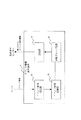
図1は、本実施の形態に係るシステム構成例を示す概要図である。
図1において、1は自動車であり、自動車1にはカーナビゲーション装置10が搭載されている。カーナビゲーション装置10は、区分エリア(メッシュ)ごとに区切られた地図データを記憶しており、この地図データを表示画面に表示する。また、別の方法として、例えばCD−ROMやDVD−ROM等に格納された地図データを読み出して表示画面に表示したり、地図データを配信する配信装置より地図データを受信して表示画面に表示してもよい。カーナビゲーション装置10は、GPS(Global Positioning System)衛星4からの測位情報を受信して現在位置の測位を行う。
また、カーナビゲーション装置10は地図データ表示装置の例に相当する。
【0026】
2aは、道路管理者(例えば、道路管理会社等)が利用する道路管理者サーバである。2bは、建設会社が利用する建設会社サーバである。2cは、警察が利用する警察サーバである。2dは、地方自治体が利用する地方自治体サーバである。2eは、地図制作会社が利用する地図制作会社サーバである。
【0027】
これら2a〜2eのサーバは、交通に関連するイベント(以下、単にイベントという)の情報収集を行い、収集した情報をオンラインにてイベント情報統合装置5に送信する。ここで、イベントとは、例えば、道路工事、交通事故、道路渋滞、一時的な通行止め、一時的な一方通行、がけ崩れ、祭りといった交通、道路に一時的な影響を与えるイベントや、新たな道路が敷設された、道路幅が拡張したといった交通、道路に恒久的な影響を与えるイベントをいう。例えば、建設会社サーバ2bが道路工事イベントの情報を収集したり、警察サーバ2cが交通事故イベントの情報を収集したり、地図制作会社サーバ2eが新規道路敷設イベントの情報を収集したりといった形で運用される。
これら2a〜2eのサーバは、それぞれ、オペレータよりイベント発生位置、イベント種別、少なくともイベント開始時刻及びイベント終了時刻のいずれかを入力し、これらの情報をオンラインにてイベント情報統合装置5に送信する。
ここで、イベント発生位置を三次元(X方向、Y方向、Z方向)で特定するようにしてもよい。このようにすれば、イベント発生位置の緯度、経度だけでなく、高度も特定することができ、例えば、一般道路の真上に高速道路が走っているような場合であっても、イベントが一般道路、高速道路のいずれで発生したのかが明確になる。また、イベント発生位置は、点(位置)として特定してもよいし、線や面(エリア)、立体(空間)として特定してもよい。また、緯度、経度による絶対位置で特定してもよいし、例えば○×交差点から南へ100mといったように相対位置で特定してもよい。
また、イベント種別は、道路工事、交通事故といったイベントの種類をいう。また、イベント開始時刻、イベント終了時刻は、たとえば、工事開始時刻、工事終了時刻であり、時刻が不明であったり未定である場合もあるので、どちらか一方のみの入力でもよいし、両方を入力してもよい。更に、新たに道路が敷設されるといった恒久的なイベントの場合は、イベント終了時刻を「∞」(無限大)とすることで地図データの改訂を行うこともできる。
【0028】
2a〜2eのサーバは、イベント発生位置及びイベント種別を示す情報をイベント属性情報として生成し、イベント開始時刻、イベント終了時刻を示す情報をイベント時刻情報として生成し、イベント属性情報及びイベント時刻情報を対応づけてイベント情報統合装置5に送信する。
図4は、イベント情報統合装置5に送信する際のデータ形式を示す概念図であり、イベント属性情報とイベント時刻情報とを対にして送信する。また、イベント属性情報とイベント時刻情報とを合わせたものをイベント情報と呼ぶ。また、2a〜2eのサーバは虚偽、不正データの排除のため、ヘッダに自身(自サーバ)の識別コードを含ませてイベント情報を送信する。
また、2a〜2eのサーバは、更に、後述する測位端末装置3からイベント情報を受信し、受信したイベント情報をイベント情報統合装置5に送信することも可能である。図1の例では、建設会社サーバ2bは、測位端末装置3からイベント情報を受信する。
なお、道路管理者サーバ2a、建設会社サーバ2b、警察サーバ2c、地方自治体サーバ2d、地図制作会社サーバ2eは、イベント情報収集装置及びイベント情報送信装置の例に相当する。
また、図1では、例として道路管理者サーバ2a、建設会社サーバ2b、警察サーバ2c、地方自治体サーバ2d、地図制作会社サーバ2eを示したが、イベント情報収集装置及びイベント情報送信装置はこれらに限られず、例えば火事イベントに関するイベント情報を送信する消防署サーバ等を追加してもよい。
【0029】
3は、イベント発生位置を測位する測位作業者が使用する測位端末装置である。図1の例では、測位作業者が工事現場において道路工事イベントのイベント発生位置を測位している状態が示されている。測位端末装置3は、GPS衛星4から測位情報を受信し、受信した測位情報に基づいてイベント発生位置を測位する。イベント発生位置は、三次元(X方向、Y方向、Z方向)で測位するようにしてもよい。このようにすれば、イベント発生位置の緯度、経度だけでなく、高度も特定することができ、例えば、一般道路の真上に高速道路が走っているような場合であっても、イベントが一般道路、高速道路のいずれで発生したのかが明確になる。
また、測位端末装置3は、測位作業者の操作により、イベント種別、イベント開始時刻、イベント終了時刻の情報を入力する。なお、ここでも、時刻が不明であったり未定である場合もあるので、イベント開始時刻、イベント終了時刻はどちらか一方のみの入力でもよいし、両方を入力してもよい。
このように、測位端末装置3ではイベント発生位置の測位だけでなく、イベント種別、イベント開始時刻、イベント終了時刻の入力が可能なため、イベントに関する情報収集が可能である。
そして、測位端末装置3は、イベント発生位置及びイベント種別をイベント属性情報とし、イベント開始時刻及びイベント終了時刻をイベント時刻情報とし、イベント属性情報とイベント時刻情報とを対応づけてイベント情報として送信する。図1の例では、道路工事イベントのイベント情報を建設会社サーバ2bに対して無線送信する。
なお、図1では、測位端末装置3は道路工事位置の測位に用いているが、これに限らず、他の種類のイベントに対する測位に用いてもよい。
【0030】
4は、カーナビゲーション装置10及び測位端末装置3に測位情報を配信するGPS衛星である。なお、GPS測位には少なくとも4機のGPS衛星からの測位情報が必要であり、図1では図示を省略しているが、カーナビゲーション装置10及び測位端末装置3は4機以上のGPS衛星から測位情報を受信しているものとする。
【0031】
5は、2a〜2eのサーバより送信されたイベント情報を受信し、受信したイベント情報に含まれるイベント属性情報を地図データの区分エリア別に統合し、統合したイベント属性情報を区分エリアごとに放送送出センター6に送信するイベント情報統合装置である。カーナビゲーション装置10が表示する地図データは区分エリアごとに区分されているため、イベント情報統合装置5は2a〜2eのサーバより別々に送信されるイベント属性情報を区分エリア別に分類し、共通の区分エリアに区分されたイベント属性情報をグループ化し、区分エリア別にグループ化したイベント属性情報を放送送出センター6を通じてカーナビゲーション装置10に配信する。
イベント情報統合装置5は、情報処理装置の例に相当する。
【0032】
6は、イベント情報統合装置5で区分エリア別に統合されたイベント属性情報を受信し、カーナビゲーション装置10に対して配信する放送送出センターである。放送送出センター6は、情報配信装置の例に相当する。
【0033】
次に、図2を参照して測位端末装置3の内部構成について説明する。
図2において、31は、GPS衛星から配信される測位情報を受信する衛星受信部である。
32は、衛星受信部31で受信した測位情報を用いてイベント発生位置の測位を行うイベント位置測位部である。前述したように、イベント位置測位部32は、イベント発生位置を三次元で測位することも可能である。
33は、イベント種別、イベント時刻(イベント開始時刻、イベント終了時刻)を入力する情報入力部である。操作の簡便化のため、情報入力部33にGUI(Graphical User Interface)などの入力支援機能を持たせてもよい。なお、情報入力部33はイベント種別入力部、イベント時刻入力部の例に相当する。また、情報入力部33は、ユーザ(測位作業者)の適正識別(=鑑定:Authentification)の機能を有していてもよい。34は、イベント位置測位部32で測位されたイベント発生位置、情報入力部33から入力されたイベント種別、イベント時刻(イベント開始時刻、イベント終了時刻)に基づきイベント情報(イベント属性情報及びイベント時刻情報)を作成する情報作成部である。
35は、情報作成部34で作成されたイベント情報を、例えば、建設会社サーバ2bに対して送信する送信部である。
なお、図2では、衛星受信部31、イベント位置測位部32、情報入力部33、情報作成部34、及び送信部35が一体となった構成が示されているが、送信部35を分離した構成であってもよく、例えば、送信部35をデータ送信機能のある携帯電話機としてもよい。
【0034】
次に、図3を参照してイベント情報統合装置5の内部構成について説明する。
図3において、51は、2a〜2eのサーバより複数のイベントについてのイベント情報(イベント属性情報及びイベント時刻情報)を受信するイベント情報受信部である。イベント情報受信部51は、サーバ2a〜2eからの信号を受信した際、送信者が予め登録されたイベント情報提供者であるか否かを識別コードなどにより照合する機能も担っている。イベント情報受信部51は、サーバ2a〜2eからの入力に対して、イベント情報の発信者の適否、データ内容の妥当性の検証を行い、データに対して「承認」(Authorization)を与えた上で、イベント情報記憶部52に転送する。
52は、イベント情報受信部51により受信されたイベント情報を記憶するイベント情報記憶部である。
53は、イベント情報記憶部52に記憶されたイベント情報について分類・グループ化処理を行う分類グループ化部である。分類グループ化部53は、イベント情報のイベント時刻情報に示されたイベント開始時刻、イベント終了時刻のいずれかと現在時刻との比較、またはイベント開始時刻及びイベント終了時刻の双方と現在時刻との比較を行い、カーナビゲーション装置10への配信対象となるイベント属性情報を選択する。具体的には、例えば、現在継続中のイベントや短時間内にスタートするイベントのイベント属性情報を配信対象として選択する。更に、分類グループ化部53は、選択したイベント属性情報に示されたイベント発生位置に基づき選択したイベント属性情報を地図データの区分エリア別に分類し、分類の結果共通の区分エリアに分類されたイベント属性情報を区分エリアごとにグループ化する。異なるイベント種別が示されたイベント属性情報であっても共通の区分エリアに分類された場合には、同一の区分エリアにてグループ化する。例えば、共通の区分エリアに分類された道路工事のイベント属性情報と交通事故のイベント属性情報とを同一の区分エリアにてグループ化する。
34は、分類グループ化部53により区分エリア別にグループ化されたイベント属性情報を区分エリアごとに放送送出センター6に送信する送信部である。
【0035】
イベント情報統合装置5は、図示していないが、例えばマイクロプロセッサ等のCPU、半導体メモリ等や磁気ディスク等の記録手段、及び通信手段を有する計算機により実現することができる。記録手段には、イベント情報統合装置5に含まれる各構成要素の機能を実現するプログラムが記録されており、CPUがこれらのプログラムを読み込むことによりイベント情報統合装置5の動作を制御し、各構成要素の機能を実現することができる。
また、各種サーバ2a〜2e、測位端末装置3も同様に計算機により実現することができ、また、これらの装置の機能を実現するプログラムを計算機で読みとり可能な記録媒体に記録することも可能である。更には、これらのプログラムを通信網を介して転送し、転送先でインストールすることも可能である。
【0036】
次に、動作について説明する。
まず、道路管理者サーバ2a、建設会社サーバ2b、警察サーバ2c、地方自治体サーバ2d、地図制作会社サーバ2eは、それぞれ任意のタイミングで、自身の識別コード、イベント発生位置、イベント種別、イベント開始時刻、イベント終了時刻の情報をオペレータから入力し、入力した情報からイベント属性情報、イベント時刻情報を生成し、イベント属性情報とイベント時刻情報とを対応づけてイベント情報としてイベント情報統合装置5に送信する。
また、工事現場において、測位作業者が測位端末装置3を用いて道路工事イベントのイベント発生位置の測位を行い、更に、測位端末装置3は測位作業者からイベント種別、イベント開始時刻、イベント終了時刻を入力し、これらの情報をイベント情報として建設会社サーバ2bに無線送信し、建設会社サーバ2bでは、測位端末装置3より受信したイベント情報をイベント情報統合装置5に送信する。
【0037】
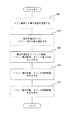
ここで、測位端末装置3における処理を図5を参照して説明する。
まず、測位作業者より測位開始の指示があると、ステップS51において衛星受信部31がGPS衛星から配信されている測位情報を受信する。衛星受信部31は、少なくとも4機のGPS衛星より測位情報を受信する。
次に、ステップS52において、イベント位置測位部32が測位情報を用いてイベント発生位置の測位を行う。図1の例では、道路工事イベントのイベント発生位置の測位を行う。
次に、ステップS53において、情報入力部33がイベント種別、イベント開始時刻、イベント終了時刻の各情報を入力する。なお、前述したように、イベント開始時刻及びイベント終了時刻はいずれか一方のみであってもよい。
次に、ステップS54において、情報作成部34がイベント発生位置、イベント種別に基づきイベント属性情報を作成し、イベント開始時刻、イベント終了時刻に基づきイベント時刻情報を作成する。
次に、ステップS55において、送信部35がイベント属性情報、イベント時刻情報を送信する。図1の例では、建設会社サーバ2bへ送信する。
なお、以上の説明では、イベント発生位置の測位を行った後にイベント種別、イベント開始時刻、イベント終了時刻を入力するとしたが、ごの順序は逆になってもよい。
【0038】
このようにして、測位端末装置3からイベント情報が送信され、また、2a〜2eのサーバからイベント情報が送信されると、イベント情報統合装置5は、これらのイベント情報を受信し、受信したイベント情報の分類・グループ化処理を行う。
図6を参照してイベント情報統合装置5における処理を説明する。
2a〜2eのサーバからイベント情報が送信される度に、ステップS61において、イベント情報受信部51が送信者の識別コードやイベント情報を受信し、識別コードが予め登録された正規の送信者のものであることを確認後、イベント情報記憶部52に記憶させる。
次に、例えば一定周期ごとに分類グループ化部53が起動し、ステップS62において、イベント情報記憶部52に記憶されているイベント属性情報の中からカーナビゲーション装置への配信対象となるイベント属性情報を選択する。具体的には、イベント時刻情報に示されたイベント開始時刻、イベント終了時刻のいずれかと現在時刻との比較、またはイベント開始時刻及びイベント終了時刻の双方と現在時刻との比較を行い、例えば、現在継続中のイベントや短時間内にスタートするイベントを判断し、これらのイベントに関するイベント属性情報を配信対象として選択する。
次に、分類グループ化部53は、ステップS63で、選択したイベント属性情報に示されたイベント発生位置に基づき選択したイベント属性情報を地図データの区分エリア別に分類する。分類グループ化部53は、それぞれの区分エリアの位置情報を有しており、イベント属性情報に示されたイベント発生位置がいずれの区分エリアに含まれるかを判断し、イベント属性情報を区分エリア別に分類する。
そして、ステップS64において、分類グループ化部53は共通の区分エリアに分類されたイベント属性情報をグループ化する。このグループ化により、カーナビゲーション装置は、同じ地域内で発生している複数のイベントをすべて地図データ上に反映させることができる。
そして、ステップS65において、送信部54が区分エリア別にグループ化されたイベント属性情報を区分エリアごとに放送送出センター6に送信する。
【0039】
なお、図6のフローチャートでは、イベント開始時刻、イベント終了時刻に基づき配信対象のイベント属性情報を選択した後(ステップS62)、選択したイベント属性情報を区分エリア別に分類し(ステップS63)、グループ化する(ステップS64)ようになっているが、これらの処理の順序を入れ替えてもよい。つまり、先にイベント属性情報を区分エリア別に分類し、その後、区分エリア別に分類されたイベント属性情報の中からイベント開始時刻、イベント終了時刻に基づき配信対象とするイベント属性情報を選択してもよい。
【0040】
放送送出センター6では、イベント情報統合装置5より送信された区分エリア別にグループ化されたイベント属性情報を区分エリアごとに配信する。
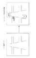
カーナビゲーション装置10では、放送送出センター6から配信されているグループ化されたイベント属性情報のうち、現在表示画面に表示している区分エリアについてのイベント属性情報を選択して受信し、受信したイベント属性情報を解析してイベント発生位置及びイベント種別を特定し、地図データ上の対応する位置にイベント種別を示すアイコンを表示する。
図7は、カーナビゲーション装置10における表示例を示す図である。
例えば、図7(a)に示す地図データが表示画面に表示されている場合に、放送送出センター6よりグループ化されたイベント属性情報を受信することにより、図7(b)に示すように複数のイベントについてそれぞれのイベントのアイコンを地図データ上に表示することができる。図7(b)では、通行止めイベント、道路工事イベント、交通事故イベントのアイコンが表示されている。
【0041】
このように、地図データ上に複数のイベントの発生状況をまとめて表示することができ、ドライバーは現在位置の周辺又は移動ルート周辺のイベント発生状況を正確かつ総合的に判断することができ、周囲の状況に合わせた効率的な走行が可能となる。
【0042】
また、イベント属性情報においてイベント発生位置が三次元で特定されている場合には、イベント発生位置の緯度、経度だけでなく、高度も特定することができ、例えば、一般道路の真上に高速道路が走っているような場合であっても、イベントが一般道路、高速道路のいずれで発生したのかを地図データ上に明示できる。
【0043】
また、測位端末装置は、イベント発生位置の測位だけでなく、イベント種別、イベント開始時刻、イベント終了時刻の入力が可能なため、測位端末装置を用いてイベントに関する情報収集を行うことができる。
【0044】
なお、以上の説明では明示しなかったが、カーナビゲーション装置がイベント属性情報を受信して地図データ上にイベント発生状況を表示するたびに課金するようにしてもよい。この場合には、カーナビゲーション装置内に課金情報生成部を設け、課金情報生成部により生成された課金情報をクレジット会社等に送信することで課金を可能にする。
【0045】
また、以上の説明では、測位端末装置は測位作業者が携帯することになっていたが、例えば、工事現場付近に配置され、工事現場であることを表示する看板に測位端末装置を搭載してもよいし、また、工事現場や交通事故現場の周囲に配置されるコーンに測位端末装置を搭載してもよい。
【0046】
また、測位端末装置は、高精度の測位が可能なD(Differential)−GPS技術、RTK(Real Time Kinematic)−GPS技術を用いてイベント発生位置の測位を行ってもよい。
【0047】
また、以上の説明では、カーナビゲーション装置を前提にしていたが、地図データを表示する装置であれば他の種類の装置でもよい。
【0048】
また、以上の説明では、イベント情報統合装置と放送送出センターはそれぞれ別の装置であったが、イベント情報統合装置と放送送出センターを統合してもよい。
【0049】
実施の形態2.
実施の形態1では、イベント情報統合装置5は、イベント属性情報(イベント発生位置、イベント種別)のみを区分エリア別にグループ化していたが、本実施の形態では、イベント時刻情報(イベント開始時刻、イベント終了時刻)も同様にグループ化し、放送送出センター6に対して区分エリア別にグループ化されたイベント情報(イベント属性情報及びイベント時刻情報)を送信する。
このようにすることで、グループ化されたイベント情報を受信したカーナビゲーション装置では、図8(b)に示すようにイベント開始時刻又はイベント終了時刻も併せて表示することができ、利便性をより向上させることができる。
【0050】
実施の形態3.
実施の形態1では、放送送出センター6は、地上波によりイベント属性情報を配信していたが、本実施の形態では、図9に示すように、準天頂衛星7を通じて情報配信を行う。図9に示した構成は、準天頂衛星7が追加された点以外は図1のものと同じである。なお、準天頂衛星7は情報配信衛星の例に相当する。
【0051】
ここで、準天頂衛星について説明する。
図10は、準天頂衛星の軌跡を説明する図であり、図10において、700は、準天頂衛星である。
準天頂衛星700は、赤道面から約45度の傾斜角になるように地球の自転に合わせて1日に1周回している。なお、赤道面からの傾斜角は、設計により任意に設定してもよい。また、準天頂衛星700は、昇交点赤経(赤道面との交点)において120度ずつ離れるように3機が配置されている。
図11は、地表面上に投影される準天頂衛星軌道の軌跡を説明する図である。図11においては、地上を固定して考えた場合に、図10における準天頂衛星700の軌跡を示している。図11に示すように、準天頂衛星700は、赤道上を交点とする「8の字」を描くように周回している。3機の準天頂衛星700は、軌道面を異にするが8時間ずつ交代するように、切れ目なく日本上空に位置している。また、地域を日本で考えた場合、仰角が60度以上の準天頂衛星700が常に存在することになる。切れ目なく日本上空に位置しているため、仰角が60度以上の準天頂衛星700が常に存在し、受信者が地上で準天頂衛星700から電波を受ける際、ビルの谷間でも電波を遮られることが少ない。
このため、準天頂衛星からイベント属性情報を配信すれば、カーナビゲーション装置10は確実にイベント属性情報を受信することができる。
【0052】
また、準天頂衛星7は測位情報も配信することができるので、測位端末装置3は測位情報を受信する4機以上のGPS衛星のうちの1機として、準天頂衛星から測位情報を受信するようにしてもよい。このように準天頂衛星から測位情報を受信することで、測位端末装置3の測位精度を向上させることができ、測位誤差を例えば25センチメートル程度に抑えることができる。このような測位精度の向上により、従来の低精度測位で必要だったマップマッチングのような地図データと自車位置との整合のための演算が不要若しくは格段に簡素化されるため、整合のための演算処理に必要としていたメモリ容量などをイベント属性情報を地図上へ反映させるための演算処理に割くことが可能になり、高精度測位によるイベント属性情報を高精度測位が可能なカーナビゲーション装置に効率的に展開することができる。
【0053】
以上では、準天頂衛星を用いた場合を説明したが、静止衛星等の他の種類の衛星からイベント属性情報を配信するようにしてもよい。
【0054】
実施の形態4.
本実施の形態では、カーナビゲーション装置が自動車の車幅と道路の道路幅とに基づき地図データ上の特定の道路データを選択し、選択した道路データを地図データ上に強調表示する場合について説明する。
【0055】
図12は、本実施の形態に係るカーナビゲーション装置10の内部構成を示す図である。
図12において、101は、GPS衛星から測位情報を受信する衛星受信部である。
102は、測位情報を用いて現在位置の測位を行う測位部である。
103は、地図データを記憶している地図データ記憶部である。
104は、現在位置を示す現在位置データを測位部102から入力し、現在位置周辺の地図データを地図データ記憶部103から読み出し、所定のデーコード処理等を行った後読み出した地図データを表示画面上に表示する地図データ管理部である。地図データ管理部104は、また、地図データ記憶部103への書き込みも可能である。
105は、地図データを表示する表示画面である。表示画面105は、GUIによる入力支援機能を有しており、例えばタッチパネル方式によりドライバー、同乗者からの指示を入力することができる。
なお、以上の101〜105に示した機能は、通常のカーナビゲーション装置の機能と同じである。
106は、例えば表示画面のGUIを通じて自動車の車幅を入力して記憶する車幅記憶部である。
107は、地図データに含まれる道路データについて、それぞれの道路データが対応する現実の道路の道路幅を記憶している道路幅記憶部である。なお、道路幅記憶部107は、地図データに含まれている道路データのすべてについて道路幅を記憶していてもよいし、一部の道路、例えばユーザが指定した道路についてのみ道路幅を記憶していてもよい。
108は、表示画面105に表示される地図データに含まれる道路データについて道路幅と車幅とを比較して特定の道路データを選択する道路データ選択部である。道路データ選択部108は、表示画面105に表示する地図データの通知を地図データ管理部104から入力し、表示対象の地図データに含まれる道路データの道路幅を道路幅記憶部107より読み出し、車幅記憶部106に記憶された車幅と比較することにより特定の道路データを選択する。
109は、道路データ選択部108により選択された道路データを表示画面105上で強調表示させる表示制御部である。
【0056】
次に動作について説明する。
なお、衛星受信部101がGPS衛星より測位情報を受信し、測位部102が現在位置を測位し、地図データ管理部104が表示画面105上に現在位置周辺の地図データを表示させるまでの処理は、従来のカーナビゲーション装置と同様であるので、説明は省略し、道路データの強調表示に関する動作を図13に従って説明する。
ドライバー等より強調表示の指示が例えば表示画面上のGUIを通じて入力されると(ステップS1301)、地図データ管理部104は、表示画面に表示している地図データ又はこれから表示しようとする地図データを道路データ選択部108に通知する(ステップS1302)。
道路データ選択部108では、通知された地図データに含まれる道路データを特定し(ステップS1303)、特定した道路データについての道路幅の情報を道路幅記憶部107より読み出し、更に、車幅記憶部106より車幅の情報を読み出し、道路幅と車幅とを比較して道路データを選択する(ステップS1304)。選択の方法としては、例えば、車幅+余裕幅≦道路幅の道路データを選択する。車幅とほぼ同じ道路幅の道路では安全に走行することが困難なため、車幅と余裕幅(例えば1メートル)を合計した幅以上の道路幅の道路、つまり車幅に対して十分広い道路幅の道路のみを選択する。
次に、道路データ選択部108は、選択した道路データを表示制御部109に通知し、表示制御部109は通知された道路データを強調表示するように表示画面105に指示し、この結果、選択された道路データが強調表示される(ステップS1305)。
強調表示の方法としては、強調表示の対象となる道路データを目立つ色(例えば赤色)で表示する、又は強調表示の対象となる道路データを他の道路データよりも太く表示する等が考えられる。
【0057】
このように、車幅よりも道路幅が十分に広い道路を強調表示することにより、ドライバーは安全に走行できる道路を容易に認識することができ、安全に走行できる道路を選択して運転することができる。特に、運転に不慣れな初心者ドライバーにとって有用である。
【0058】
なお、以上では、車幅よりも道路幅が十分に広い道路を強調表示をすることとしたが、逆に、車幅に対して道路幅が十分でない道路、つまり安全な走行が困難な道路をを強調表示し、安全な走行が困難な道路を避けて走行するようにしてもよい。
【0059】
また、以上の説明では、地図データを内部で記憶しているカーナビゲーション装置を前提としていたが、これに限らず、CD−ROMやDVD−ROM等に格納された地図データを読み出して表示画面に表示するカーナビゲーション装置や、地図データを配信する配信装置より地図データを受信して表示画面に表示するカーナビゲーション装置にも適用可能である。
【0060】
実施の形態5.
本実施の形態では、カーナビゲーション装置が所定の情報配信装置より道路幅を示す道路幅情報を受信し、受信した道路幅情報を用いて強調表示を行う道路データを選択する場合について説明する。
【0061】
図14は、本実施の形態に係るシステム構成例を示す概要図であり、1はカーナビゲーション装置10を搭載した自動車、4は測位情報を配信するGPS衛星、6は道路幅情報を配信する放送送出センター、8は道路幅情報を生成する道路幅情報生成装置である。
道路幅情報生成装置8は、地図データに含まれている全ての道路データの道路幅を表示する道路幅情報を生成してもよいし、一部の道路データの道路幅を表示する道路幅情報を生成してもよい。また、カーナビゲーション装置から要求があった道路データの道路幅のみを表示する道路幅情報を生成してもよい。
また、道路幅情報生成装置8は、生成した道路幅情報を放送送出センター6に送信し、放送送出センター6はカーナビゲーション装置に対して道路幅情報を配信する。図14では、放送送出センター6は地上波により道路幅情報を配信することとしているが、準天頂衛星等の人工衛星から道路幅情報を配信してもよい。
【0062】
図15は、本実施の形態に係るカーナビゲーション装置10の内部構成を示す図であり、受信部110を追加した以外は図12に示す構成と同じである。
受信部110は、放送送出センター6から配信される道路幅情報を受信し、受信した道路幅情報を道路幅記憶部107に書き込む。
101〜109の各要素の動作は実施の形態4に示したものと同じであり、道路データ選択部108は、道路幅記憶部107に記憶された道路幅と車幅記憶部106に記憶された車幅とを比較して特定の道路データを選択し、表示制御部109が選択された道路データを強調表示させる。
【0063】
このように、本実施の形態では、道路幅情報を配信しているため、カーナビゲーション装置は道路幅の情報を保持している必要がなく、カーナビゲーション装置のメモリ容量を抑えることができる。
【0064】
実施の形態6.
本実施の形態では、カーナビゲーション装置が道路での事故発生率に基づき地図データ上の特定の道路データを選択し、選択した道路データを地図データ上に強調表示する場合について説明する。
【0065】
図16は、本実施の形態に係るカーナビゲーション装置10の内部構成を示す図である。
図16において、101〜105及び108、109の各要素は図12に示したものと同じなので、説明を省略する。
111は、事故発生率についての閾値を記憶する閾値記憶部である。例えば、ドライバーの運転経験年数を入力させ、入力された運転経験年数に応じて閾値を設定するようにしてもよい。運転経験年数が少ないほど閾値を低くし、事故発生率の低い道路のみを選択するようにしてもよい。また、運転経験年数とは無関係に、ドライバーが指定する事故発生率を閾値として記憶してもよい。
112は、地図データに含まれる道路データについて、それぞれの道路データが対応する現実の道路での事故発生率を記憶している事故発生率記憶部である。なお、事故発生率記憶部112は、地図データに含まれている道路データのすべてについて事故発生率を記憶していてもよいし、一部の道路、例えばユーザが指定した道路についてのみ事故発生率を記憶していてもよい。
なお、道路データ選択部108は、閾値記憶部111に記憶された事故発生率の閾値と事故発生率記憶部112に記憶された事故発生率とを比較して特定の道路データを選択する。
【0066】
次に図17を参照して動作を説明する。
なお、ステップS1701〜S1703は、図13に示したステップS301〜S1303と同じであるため、ステップS1704から説明を開始する。
道路データ選択部108では、ステップS1703で特定した道路データについての事故発生率を事故発生率記憶部112より読み出し、更に、閾値記憶部111より事故発生率の閾値を読み出し、各道路データの事故発生率と事故発生率の閾値とを比較して特定の道路データを選択する(ステップS1704)。選択の方法としては、例えば、事故発生率が閾値以下の道路、つまり事故発生率が低い比較的安全な道路の道路データを選択することが考えられる。
次に、道路データ選択部108は、選択した道路データを表示制御部109に通知し、表示制御部109は通知された道路データを強調表示するように表示画面105に指示し、この結果、選択された道路データが強調表示される(ステップS1705)。
【0067】
このように、事故発生率が低い安全な道路を強調表示することにより、ドライバーは安全に走行できる道路を容易に認識することができ、安全に走行できる道路を選択して運転することができる。特に、運転に不慣れな初心者ドライバーにとって有用である。
【0068】
なお、以上では、事故発生率の低い比較的安全な道路を強調表示をすることとしたが、逆に、事故発生率の高い道路、つまり危険と考えられる道路を強調表示し、このような危険な道路を避けて走行するようにしてもよい。
【0069】
また、以上の説明では、地図データを内部で記憶しているカーナビゲーション装置を前提としていたが、これに限らず、CD−ROMやDVD−ROM等に格納された地図データを読み出して表示画面に表示するカーナビゲーション装置や、地図データを配信する配信装置より地図データを受信して表示画面に表示するカーナビゲーション装置にも適用可能である。
【0070】
実施の形態7.
本実施の形態では、カーナビゲーション装置が所定の情報配信装置より事故発生率を示す事故発生率情報を受信し、受信した事故発生率情報を用いて強調表示を行う道路データを選択する場合について説明する。
【0071】
図18は、本実施の形態に係るシステム構成例を示す概要図であり、1はカーナビゲーション装置10を搭載した自動車、4は測位情報を配信するGPS衛星、6は道路幅情報を配信する放送送出センター、9は事故発生率情報を生成する事故発生率情報生成装置である。
事故発生率情報生成装置9は、地図データに含まれている全ての道路データの事故発生率を表示する事故発生率情報を生成してもよいし、一部の道路データの事故発生率を表示する事故発生率情報を生成してもよい。また、カーナビゲーション装置から要求があった道路データの事故発生率のみを表示する事故発生率情報を生成してもよい。
また、事故発生率情報生成装置9は、生成した事故発生率情報を放送送出センター6に送信し、放送送出センター6はカーナビゲーション装置に対して事故発生率情報を配信する。図14では、放送送出センター6は地上波により事故発生率情報を配信することとしているが、準天頂衛星等の人工衛星から事故発生率情報を配信してもよい。
【0072】
図19は、本実施の形態に係るカーナビゲーション装置10の内部構成を示す図であり、受信部113を追加した以外は図16に示す構成と同じである。
受信部113は、放送送出センター6から配信される事故発生率情報を受信し、受信した事故発生率情報を事故発生率記憶部112に書き込む。
101〜105、108、109、111、112の要素の動作は実施の形態6に示したものと同じであり、道路データ選択部108は、事故発生率記憶部112に記憶された事故発生率と閾値記憶部111に記憶された事故発生率の閾値とを比較して特定の道路データを選択し、表示制御部109が選択された道路データを強調表示させる。
【0073】
このように、本実施の形態では、事故発生率情報を配信しているため、カーナビゲーション装置は事故発生率の情報を保持している必要がなく、カーナビゲーション装置のメモリ容量を抑えることができる。
【0074】
【発明の効果】
本発明によれば、測位端末装置は、イベント発生位置の測位だけでなく、イベント種別、イベント開始時刻、イベント終了時刻の入力が可能なため、測位端末装置を用いてイベントに関する情報収集を行うことができる。
【0075】
また、本発明によれば、イベント属性情報を区分エリアごとに分類し、共通の区分エリアに分類されたイベント属性情報をグループ化するため、地図データ表示装置では複数のイベントの発生状況を地図データ上にまとめて表示することができ、ユーザはイベント発生状況を正確かつ総合的に判断することができる。
【0076】
また、本発明によれば、イベント属性情報及びイベント時刻情報を区分エリアごとに分類し、共通の区分エリアに分類されたイベント属性情報及びイベント時刻情報をグループ化するため、地図データ表示装置では複数のイベントについてイベント開始時刻、イベント終了時刻を併せて地図データ上に表示することができ、ユーザはイベント発生状況をより正確かつ総合的に判断することができる。
【0077】
また、本発明によれば、情報配信衛星を介してイベント属性情報の配信が行われるため、建物等によって遮られることなく、地図データ表示装置が確実にイベント属性情報を受信できるようになる。
【0078】
また、本発明によれば、イベント発生位置を三次元で特定するイベント属性情報を配信するため、イベント発生位置の緯度、経度だけでなく、高度も特定することができ、イベント発生状況をより正確に表示できる。
【図面の簡単な説明】
【図1】 実施の形態1に係るシステム構成例を示す図。
【図2】 実施の形態1に係る測位端末装置の内部構成例を示す図。
【図3】 実施の形態1に係るイベント情報統合装置の内部構成例を示す図。
【図4】 イベント情報の例を示す図。
【図5】 実施の形態1に係る測位端末装置の処理の内容を示すフローチャート図。
【図6】 実施の形態1に係るイベント情報統合装置の処理の内容を示すフローチャート図。
【図7】 実施の形態1に係るカーナビゲーション装置での地図データ表示例を示す図。
【図8】 実施の形態2に係るカーナビゲーション装置での地図データ表示例を示す図。
【図9】 実施の形態3に係るシステム構成例を示す図。
【図10】 実施の形態4に係るカーナビゲーション装置の内部構成例を示す図。
【図11】 実施の形態4に係るカーナビゲーション装置の処理の内容を示すフローチャート図。
【図12】 準天頂衛星の軌跡を説明する図。
【図13】 準天頂衛星の軌跡を説明する図。
【図14】 実施の形態5に係るシステム構成例を示す図。
【図15】 実施の形態5に係るカーナビゲーション装置の内部構成例を示す図。
【図16】 実施の形態6に係るカーナビゲーション装置の内部構成例を示す図。
【図17】 実施の形態6に係るカーナビゲーション装置の処理の内容を示すフローチャート図。
【図18】 実施の形態7に係るシステム構成例を示す図。
【図19】 実施の形態7に係るカーナビゲーション装置の内部構成例を示す図。
【符号の説明】
1 自動車、2a 道路管理者サーバ、2b 建設会社サーバ、2c 警察サーバ、2d 地方自治体サーバ、2e 地図制作会社サーバ、3 測位端末装置、4 GPS衛星、5 イベント情報統合装置、6 放送送出センター、7 準天頂衛星、8 道路幅情報生成装置、9 事故発生率情報生成装置、10 カーナビゲーション装置、31 衛星受信部、32 イベント位置測位部、33 情報入力部、34 情報作成部、35 送信部、51 イベント情報受信部、52イベント情報記憶部、53 分類グループ化部、54 送信部、101 衛星受信部、102 測位部、103 地図データ記憶部、104 地図データ管理部、105 表示画面、106 車幅記憶部、107 道路幅記憶部、108 道路データ選択部、109 表示制御部、110 受信部、111 閾値記憶部、112 事故発生率記憶部、113 受信部。[0001]
BACKGROUND OF THE INVENTION
The present invention relates to a technique for displaying in real time an occurrence state of an event related to traffic on map data displayed on a car navigation device or the like.
[0002]
[Prior art]
As a technique for displaying traffic information on map data of a car navigation device, there is a “car navigation device and program storage medium” disclosed in JP-A-10-73441. In the above publication, a TV (television) broadcasting station broadcasts information on a traffic jam area obtained from a traffic center of the Metropolitan Police Department and position data obtained from the traffic jam information as character information. It is described that a traffic jam area is displayed on the map data according to the character information from.
According to the above publication, the TV broadcasting station can transmit the construction area information and the empty parking lot information as character information according to the same procedure, and the car navigation device displays the construction area information and the empty parking lot information on the map data. It is stated that it can be done.
[0003]
[Problems to be solved by the invention]
As described above, in the above-described prior art, the TV broadcasting station can broadcast traffic jam information, construction area information, and vacant parking lot information as character broadcast.
However, the TV broadcasting station broadcasts traffic jam information, construction area information, and vacant parking lot information individually, and the car navigation system displays each of the traffic jam information, construction area information, and vacant parking lot information independently. ing. In order to comprehensively determine the situation around the current position and the situation around the moving route, it is desirable to display multiple pieces of information related to traffic on the map data. The construction area information and the empty parking lot information are displayed separately. Therefore, the user has to check each of the traffic jam information, the construction area information, and the empty parking lot information individually. In the prior art, information was collected from the traffic center of the Metropolitan Police Department, but no consideration was given to how to collect individual information accurately and in real time.
[0004]
The main object of the present invention is to solve the problems of the prior art as described above. Information on events related to traffic is collected and integrated accurately and in real time, and the occurrence status of a plurality of events is determined. The main purpose is to display the map data together.
[0005]
[Means for Solving the Problems]
The terminal device according to the present invention is
A terminal device that transmits information about an event to an event information collection device that collects information on events related to traffic,
An event position positioning unit for positioning the event occurrence position;
An event type input section for inputting an event type,
An event time input unit for inputting at least one of an event start time and an event end time;
And a transmission unit that transmits information indicating at least one of an event occurrence position, an event type, and an event start time and an event end time to the event information collection device.
[0006]
The terminal device can communicate with a GPS (Global Positioning System) satellite,
The terminal device further includes:
It has a satellite receiver that receives positioning information from GPS satellites,
The event position positioning unit
The positioning of the event occurrence position is performed using the positioning information received by the satellite receiver.
[0007]
The event position positioning unit
RTK (Real Time Kinematic) —Measures an event occurrence position based on GPS technology.
[0008]
The event position positioning unit
It is characterized by three-dimensional positioning of the event occurrence position.
[0009]
An information processing apparatus according to the present invention includes:
For event related to traffic, a plurality of event information for transmitting event attribute information indicating event occurrence position and event type and event time information indicating at least one of event start time and event end time in association with each other A transmitting device;
In order to reflect the event occurrence status on the map data and display it on the map data display device that displays the map data classified by the classification area, it is connected to the information distribution device that distributes the event attribute information for each classification area,
For a plurality of events, a receiving unit that receives event attribute information and event time information from a plurality of event information transmitting devices;
Based on at least one of the event start time and event end time indicated in the event time information, the event attribute information to be distributed to the map data display device is selected, and the event occurrence position indicated in the selected event attribute information is selected. A classification grouping unit that classifies the event attribute information selected based on the classification area, and groups the event attribute information classified into the common classification area as a result of the classification for each classification area;
And a transmission unit that transmits the event attribute information grouped for each divided area by the classification grouping unit to the information distribution apparatus for each divided area.
[0010]
The classification grouping unit includes:
A plurality of pieces of event attribute information indicating different event types are grouped in the same section area.
[0011]
The information processing apparatus is connected to an information distribution apparatus that distributes event attribute information and event time information for each divided area,
The classification grouping unit includes:
Event attribute information and event time information classified into common area as a result of classification by classifying event attribute information and corresponding event time information selected based on event occurrence position indicated in selected event attribute information by classification area Are grouped by area,
The transmitter is
Event attribute information and event time information grouped by classification area by the classification grouping unit are transmitted to the information distribution apparatus for each classification area.
[0012]
The information processing apparatus includes:
It is connected to an information distribution apparatus that distributes event attribute information via an information distribution satellite that performs information distribution.
[0013]
The information processing apparatus includes:
Event attribute information for specifying an event occurrence position in three dimensions is transmitted to the information distribution apparatus for each divided area.
[0020]
An information processing method according to the present invention includes:
For event related to traffic, a plurality of event information for transmitting event attribute information indicating event occurrence position and event type and event time information indicating at least one of event start time and event end time in association with each other A transmitting device;
Communicates with an information distribution device that distributes event attribute information for each classification area in order to reflect the event occurrence status on the map data and display it on the map data display device that displays the map data classified by classification area Information processing method for processing event attribute information,
A reception step of receiving event attribute information and event time information from a plurality of event information transmitting devices for a plurality of events,
Based on at least one of the event start time and event end time indicated in the event time information, the event attribute information to be distributed to the map data display device is selected, and the event occurrence position indicated in the selected event attribute information is selected. A classification grouping step for classifying the event attribute information selected based on the classification area, and grouping the event attribute information classified into the common classification area as a result of the classification for each classification area;
A transmission step of transmitting the event attribute information grouped for each divided area by the classification grouping step to the information distribution apparatus for each divided area.
[0025]
DETAILED DESCRIPTION OF THE INVENTION
Embodiment 1 FIG.
FIG. 1 is a schematic diagram showing a system configuration example according to the present embodiment.
In FIG. 1, reference numeral 1 denotes an automobile, and the automobile 1 is equipped with a
The
[0026]
2a is a road administrator server used by a road administrator (for example, a road management company). A
[0027]
These
Each of the
Here, the event occurrence position may be specified in three dimensions (X direction, Y direction, Z direction). In this way, it is possible to specify not only the latitude and longitude of the event occurrence location, but also the altitude. For example, even if an expressway runs directly above a general road, It will be clear whether it occurred on the road or the expressway. Further, the event occurrence position may be specified as a point (position), or may be specified as a line, a surface (area), or a solid (space). Moreover, you may specify by the absolute position by a latitude and longitude, for example, you may specify by relative position like 100m south from (circle) x intersection.
The event type refers to an event type such as road construction or a traffic accident. The event start time and event end time are, for example, the construction start time and the construction end time. Since the time may be unknown or undecided, either one of them may be entered, or both may be entered. May be. Furthermore, in the case of a permanent event where a new road is laid, the map data can be revised by setting the event end time to “∞” (infinity).
[0028]
The
FIG. 4 is a conceptual diagram showing a data format for transmission to the event information integration device 5, in which event attribute information and event time information are transmitted in pairs. A combination of event attribute information and event time information is referred to as event information. In addition, the
Further, the
The
In FIG. 1, the
[0029]
Reference numeral 3 denotes a positioning terminal device used by a positioning operator who measures an event occurrence position. In the example of FIG. 1, a state in which the positioning operator is measuring the event occurrence position of the road construction event at the construction site is shown. The positioning terminal device 3 receives the positioning information from the GPS satellite 4 and measures the event occurrence position based on the received positioning information. The event occurrence position may be measured in three dimensions (X direction, Y direction, Z direction). In this way, it is possible to specify not only the latitude and longitude of the event occurrence location, but also the altitude. For example, even if an expressway runs directly above a general road, It will be clear whether it occurred on the road or the expressway.
In addition, the positioning terminal device 3 inputs information on an event type, an event start time, and an event end time by an operation of a positioning operator. In this case as well, since the time may be unknown or undecided, either the event start time or the event end time may be input, or both may be input.
As described above, since the positioning terminal device 3 can input the event type, the event start time, and the event end time as well as the event occurrence position, it is possible to collect information about the event.
Then, the positioning terminal device 3 uses the event occurrence position and event type as event attribute information, uses the event start time and event end time as event time information, and associates the event attribute information and event time information as event information. . In the example of FIG. 1, event information on road construction events is wirelessly transmitted to the
In FIG. 1, the positioning terminal device 3 is used for positioning the road construction position, but is not limited thereto, and may be used for positioning for other types of events.
[0030]
Reference numeral 4 denotes a GPS satellite that distributes positioning information to the
[0031]
5 receives the event information transmitted from the
The event information integration device 5 corresponds to an example of an information processing device.
[0032]
Reference numeral 6 denotes a broadcast transmission center that receives event attribute information integrated for each divided area by the event information integration device 5 and distributes the event attribute information to the
[0033]
Next, the internal configuration of the positioning terminal device 3 will be described with reference to FIG.
In FIG. 2, 31 is a satellite receiver for receiving positioning information distributed from GPS satellites.
33 is an information input unit for inputting an event type and event time (event start time, event end time). In order to simplify the operation, the
2 shows a configuration in which the
[0034]
Next, the internal configuration of the event information integration device 5 will be described with reference to FIG.
In FIG. 3,
An event information storage unit 52 stores event information received by the event
[0035]
Although not shown, the event information integration device 5 can be realized by a computer having a CPU such as a microprocessor, a recording unit such as a semiconductor memory or a magnetic disk, and a communication unit. The recording means records a program that realizes the function of each component included in the event information integration device 5. The CPU reads these programs to control the operation of the event information integration device 5. The function of the element can be realized.
The
[0036]
Next, the operation will be described.
First, the
At the construction site, the positioning worker measures the event occurrence position of the road construction event using the positioning terminal device 3, and the positioning terminal device 3 receives the event type, event start time, event end time from the positioning operator. Is transmitted to the
[0037]
Here, the process in the positioning terminal device 3 is demonstrated with reference to FIG.
First, when a positioning operator gives an instruction to start positioning, in step S51, the
Next, in step S52, the event
Next, in step S53, the
Next, in step S54, the
Next, in step S55, the
In the above description, the event type, the event start time, and the event end time are input after positioning the event occurrence position. However, the order may be reversed.
[0038]
In this way, when event information is transmitted from the positioning terminal device 3 and event information is transmitted from the
Processing in the event information integration device 5 will be described with reference to FIG.
Each time event information is transmitted from the
Next, for example, the
Next, in step S63, the
In step S64, the
In step S65, the
[0039]
In the flowchart of FIG. 6, after selecting event attribute information to be distributed based on the event start time and event end time (step S62), the selected event attribute information is classified by classification area (step S63) and grouped. (Step S64), the order of these processes may be changed. In other words, event attribute information may be classified first by category area, and then event attribute information to be distributed may be selected from the event attribute information classified by category area based on the event start time and event end time. .
[0040]
The broadcast transmission center 6 distributes the event attribute information grouped for each divided area transmitted from the event information integration device 5 for each divided area.
The
FIG. 7 is a view showing a display example in the
For example, when the map data shown in FIG. 7A is displayed on the display screen, a plurality of pieces of event attribute information grouped from the broadcast transmission center 6 are received as shown in FIG. 7B. The icon of each event can be displayed on the map data. In FIG. 7B, icons for a closed event, a road construction event, and a traffic accident event are displayed.
[0041]
In this way, the occurrence status of multiple events can be displayed together on the map data, and the driver can accurately and comprehensively determine the event occurrence status around the current position or around the moving route. It is possible to run efficiently according to the situation.
[0042]
In addition, when the event occurrence position is specified in three dimensions in the event attribute information, not only the latitude and longitude of the event occurrence position but also the altitude can be specified. For example, an expressway directly above a general road Even if you are running, you can clearly indicate on the map data whether the event occurred on a general road or an expressway.
[0043]
In addition, since the positioning terminal device can input not only the location of the event occurrence position but also the event type, the event start time, and the event end time, it can collect information about the event using the positioning terminal device.
[0044]
Although not specified in the above description, the car navigation device may be charged each time the event attribute information is received and the event occurrence status is displayed on the map data. In this case, a billing information generation unit is provided in the car navigation device, and billing is enabled by transmitting the billing information generated by the billing information generation unit to a credit company or the like.
[0045]
In the above description, the positioning terminal device is supposed to be carried by the positioning operator. For example, the positioning terminal device is installed near a construction site and mounted on a signboard indicating that it is a construction site. Alternatively, a positioning terminal device may be mounted on a cone arranged around a construction site or a traffic accident site.
[0046]
In addition, the positioning terminal device may measure the event occurrence position by using D (Differential) -GPS technology and RTK (Real Time Kinetic) -GPS technology capable of highly accurate positioning.
[0047]
In the above description, the car navigation device is assumed, but other types of devices may be used as long as they display map data.
[0048]
In the above description, the event information integration device and the broadcast transmission center are separate devices, but the event information integration device and the broadcast transmission center may be integrated.
[0049]
In the first embodiment, the event information integration device 5 groups only the event attribute information (event occurrence position, event type) for each divided area. However, in this embodiment, the event time information (event start time, event type) End time) is also grouped in the same manner, and event information (event attribute information and event time information) grouped by section area is transmitted to the broadcast transmission center 6.
In this way, the car navigation device that has received the grouped event information can also display the event start time or the event end time as shown in FIG. Can be improved.
[0050]
Embodiment 3 FIG.
In the first embodiment, the broadcast transmission center 6 distributes the event attribute information by terrestrial waves. However, in the present embodiment, the information is distributed through the quasi-zenith satellite 7 as shown in FIG. The configuration shown in FIG. 9 is the same as that of FIG. 1 except that the quasi-zenith satellite 7 is added. The quasi-zenith satellite 7 corresponds to an example of an information distribution satellite.
[0051]
Here, the quasi-zenith satellite will be described.
FIG. 10 is a diagram for explaining the locus of a quasi-zenith satellite. In FIG. 10,
The
FIG. 11 is a diagram for explaining the trajectory of the quasi-zenith satellite orbit projected onto the ground surface. FIG. 11 shows the locus of the
For this reason, if the event attribute information is distributed from the quasi-zenith satellite, the
[0052]
Further, since the quasi-zenith satellite 7 can also deliver positioning information, the positioning terminal device 3 receives positioning information from the quasi-zenith satellite as one of four or more GPS satellites that receive positioning information. It may be. Thus, by receiving the positioning information from the quasi-zenith satellite, the positioning accuracy of the positioning terminal device 3 can be improved, and the positioning error can be suppressed to about 25 centimeters, for example. This improvement in positioning accuracy eliminates the need for calculations for matching map data with the vehicle position, such as map matching, which was necessary for conventional low-accuracy positioning. It is possible to divide the memory capacity required for the calculation processing of the event into the calculation processing for reflecting the event attribute information on the map, and to the car navigation device capable of high-precision positioning of the event attribute information by high-precision positioning Can be deployed efficiently.
[0053]
The case where the quasi-zenith satellite is used has been described above. However, event attribute information may be distributed from other types of satellites such as geostationary satellites.
[0054]
Embodiment 4 FIG.
In the present embodiment, a case will be described in which the car navigation device selects specific road data on map data based on the width of a car and the road width of the road, and highlights the selected road data on the map data. .
[0055]
FIG. 12 is a diagram showing an internal configuration of the
In FIG. 12,
104, the current position data indicating the current position is input from the
A
The
A road data selection unit 108 selects specific road data by comparing road width and vehicle width for road data included in map data displayed on the
[0056]
Next, the operation will be described.
Processing until the
When an instruction for highlighting is input from a driver or the like through, for example, a GUI on the display screen (step S1301), the map
The road data selection unit 108 specifies road data included in the notified map data (step S1303), reads road width information about the specified road data from the road
Next, the road data selection unit 108 notifies the
As a highlighting method, road data to be highlighted can be displayed in a conspicuous color (for example, red), or road data to be highlighted can be displayed thicker than other road data.
[0057]
In this way, by highlighting roads that are sufficiently wider than the vehicle width, the driver can easily recognize roads that can be driven safely, and select and drive roads that can be driven safely Can do. This is especially useful for novice drivers who are unfamiliar with driving.
[0058]
In the above, roads that are sufficiently wider than the vehicle width are highlighted, but conversely, roads that do not have enough road width relative to the vehicle width, that is, roads that are difficult to drive safely. May be highlighted to drive away from roads that are difficult to drive safely.
[0059]
In the above description, a car navigation device that stores map data internally is assumed. However, the present invention is not limited to this, and map data stored in a CD-ROM, DVD-ROM, or the like is read and displayed on the display screen. The present invention is also applicable to a car navigation device that displays and a car navigation device that receives map data from a distribution device that distributes map data and displays the map data on a display screen.
[0060]
Embodiment 5 FIG.
In the present embodiment, a case will be described in which the car navigation device receives road width information indicating a road width from a predetermined information distribution device, and selects road data to be highlighted using the received road width information.
[0061]
FIG. 14 is a schematic diagram showing a system configuration example according to the present embodiment, in which 1 is an automobile equipped with a
The road width information generation device 8 may generate road width information that displays the road width of all road data included in the map data, or road width information that displays the road width of some road data. May be generated. Alternatively, road width information for displaying only the road width of the road data requested by the car navigation device may be generated.
The road width information generation device 8 transmits the generated road width information to the broadcast transmission center 6, and the broadcast transmission center 6 distributes the road width information to the car navigation device. In FIG. 14, the broadcast transmission center 6 distributes road width information by terrestrial waves. However, the road width information may be distributed from an artificial satellite such as a quasi-zenith satellite.
[0062]
FIG. 15 is a diagram showing an internal configuration of the
The receiving
The operations of the
[0063]
Thus, in this embodiment, since the road width information is distributed, the car navigation device does not need to hold the road width information, and the memory capacity of the car navigation device can be suppressed.
[0064]
Embodiment 6 FIG.
In the present embodiment, a case will be described in which the car navigation device selects specific road data on map data based on the accident occurrence rate on the road, and highlights the selected road data on the map data.
[0065]
FIG. 16 is a diagram showing an internal configuration of the
In FIG. 16, the
An accident occurrence
The road data selection unit 108 compares the accident occurrence rate threshold stored in the
[0066]
Next, the operation will be described with reference to FIG.
Since steps S1701 to S1703 are the same as steps S301 to S1303 shown in FIG. 13, the description starts from step S1704.
In the road data selection unit 108, the accident occurrence rate for the road data specified in step S1703 is read from the accident occurrence
Next, the road data selection unit 108 notifies the
[0067]
In this way, by highlighting a safe road with a low accident rate, the driver can easily recognize a road that can be safely driven, and can select and drive a road that can be safely driven. This is especially useful for novice drivers who are unfamiliar with driving.
[0068]
In the above, relatively safe roads with a low accident rate are highlighted, but conversely, roads with a high accident rate, that is, roads that are considered dangerous are highlighted. You may make it drive | work avoiding a difficult road.
[0069]
In the above description, a car navigation device that stores map data internally is assumed. However, the present invention is not limited to this, and map data stored in a CD-ROM, DVD-ROM, or the like is read and displayed on the display screen. The present invention is also applicable to a car navigation device that displays and a car navigation device that receives map data from a distribution device that distributes map data and displays the map data on a display screen.
[0070]
Embodiment 7 FIG.
In this embodiment, the car navigation device receives accident occurrence rate information indicating an accident occurrence rate from a predetermined information distribution device, and selects road data to be highlighted using the received accident occurrence rate information. To do.
[0071]
FIG. 18 is a schematic diagram showing a system configuration example according to the present embodiment, in which 1 is an automobile equipped with a
The accident occurrence rate
In addition, the accident occurrence rate
[0072]
FIG. 19 is a diagram showing an internal configuration of the
The receiving
The operations of the
[0073]
As described above, in this embodiment, since the accident rate information is distributed, the car navigation device does not need to hold the information on the accident rate, and the memory capacity of the car navigation device can be suppressed. .
[0074]
【The invention's effect】
According to the present invention, since the positioning terminal device can input not only the positioning of the event occurrence position but also the event type, the event start time, and the event end time, it can collect information about the event using the positioning terminal device. Can do.
[0075]
Further, according to the present invention, the event attribute information is classified for each divided area, and the event attribute information classified into the common divided area is grouped. The user can determine the event occurrence status accurately and comprehensively.
[0076]
Further, according to the present invention, the event attribute information and the event time information are classified for each divided area, and the event attribute information and the event time information classified into the common divided area are grouped. The event start time and event end time can be displayed together on the map data, and the user can more accurately and comprehensively determine the event occurrence status.
[0077]
Further, according to the present invention, since the event attribute information is distributed via the information distribution satellite, the map data display device can reliably receive the event attribute information without being blocked by a building or the like.
[0078]
Further, according to the present invention, since event attribute information for specifying the event occurrence position in three dimensions is distributed, not only the latitude and longitude of the event occurrence position but also the altitude can be specified, and the event occurrence status can be more accurately determined. Can be displayed.
[Brief description of the drawings]
FIG. 1 is a diagram showing a system configuration example according to a first embodiment.
FIG. 2 is a diagram showing an internal configuration example of a positioning terminal apparatus according to Embodiment 1;
FIG. 3 is a diagram showing an internal configuration example of an event information integration device according to the first embodiment.
FIG. 4 is a diagram showing an example of event information.
FIG. 5 is a flowchart showing the processing contents of the positioning terminal device according to the first embodiment.
FIG. 6 is a flowchart showing the processing contents of the event information integration device according to the first embodiment.
FIG. 7 is a diagram showing a map data display example in the car navigation device according to the first embodiment.
FIG. 8 is a diagram showing a map data display example in the car navigation device according to the second embodiment.
FIG. 9 is a diagram showing a system configuration example according to a third embodiment.
FIG. 10 is a diagram showing an internal configuration example of a car navigation device according to Embodiment 4;
FIG. 11 is a flowchart showing the contents of processing of the car navigation device according to the fourth embodiment.
FIG. 12 is a diagram for explaining the locus of a quasi-zenith satellite.
FIG. 13 is a diagram for explaining the locus of a quasi-zenith satellite.
FIG. 14 is a diagram showing a system configuration example according to a fifth embodiment.
FIG. 15 is a diagram illustrating an internal configuration example of a car navigation device according to Embodiment 5;
FIG. 16 is a diagram illustrating an internal configuration example of a car navigation device according to a sixth embodiment.
FIG. 17 is a flowchart showing the contents of processing of the car navigation device according to Embodiment 6;
FIG. 18 shows a system configuration example according to the seventh embodiment.
FIG. 19 is a diagram illustrating an internal configuration example of a car navigation device according to a seventh embodiment.
[Explanation of symbols]
1 automobile, 2a road administrator server, 2b construction company server, 2c police server, 2d local government server, 2e map production company server, 3 positioning terminal device, 4 GPS satellite, 5 event information integration device, 6 broadcast transmission center, 7 Quasi-zenith satellite, 8 road width information generation device, 9 accident occurrence rate information generation device, 10 car navigation device, 31 satellite reception unit, 32 event position positioning unit, 33 information input unit, 34 information creation unit, 35 transmission unit, 51 Event information reception unit, 52 event information storage unit, 53 classification grouping unit, 54 transmission unit, 101 satellite reception unit, 102 positioning unit, 103 map data storage unit, 104 map data management unit, 105 display screen, 106 vehicle width storage Part, 107 road width storage part, 108 road data selection part, 109 display control part, 110 reception part, 111 threshold value憶部, 112 accident rate storage unit, 113 reception unit.
Claims (13)
イベント発生位置の測位を行うイベント位置測位部と、
イベント種別を入力するイベント種別入力部と、
イベント開始時刻及びイベント終了時刻を入力するイベント時刻入力部と、
イベント発生位置と、イベント種別と、イベント開始時刻と、イベント終了時刻とを示す情報をイベント情報収集装置に対して送信する送信部とを有することを特徴とする端末装置。A terminal device that transmits information about an event to an event information collection device that collects information on events related to traffic,
An event position positioning unit for positioning the event occurrence position;
An event type input section for inputting an event type,
An event time input unit for inputting an event start time and an event end time;
And event occurrence location, event type and the terminal device characterized in that it comprises an event start time, and a transmission unit that transmits information indicating an event end time for the event information collecting apparatus.
前記端末装置は、更に、
GPS衛星より測位情報を受信する衛星受信部を有し、
前記イベント位置測位部は、
前記衛星受信部により受信された測位情報を用いてイベント発生位置の測位を行うことを特徴とする請求項1に記載の端末装置。The terminal device can communicate with a GPS (Global Positioning System) satellite,
The terminal device further includes:
It has a satellite receiver that receives positioning information from GPS satellites,
The event position positioning unit
The terminal device according to claim 1, wherein the event occurrence position is measured using the positioning information received by the satellite receiver.
RTK(Real Time Kinematic)−GPS技術に基づきイベント発生位置の測位を行うことを特徴とする請求項2に記載の端末装置。The event position positioning unit
The terminal device according to claim 2, wherein an event occurrence position is measured based on RTK (Real Time Kinematic) -GPS technology.
イベント発生位置の三次元測位を行うことを特徴とする請求項1に記載の端末装置。The event position positioning unit
The terminal device according to claim 1, wherein three-dimensional positioning of an event occurrence position is performed.
区分エリア別に区分された地図データを表示する地図データ表示装置にイベント発生状況を地図データ上に反映させて表示させるために、区分エリアごとにイベント属性情報を配信する情報配信装置とに接続される情報処理装置において、
複数のイベントについて、イベント属性情報とイベント時刻情報とを複数のイベント情報送信装置より受信する受信部と、
イベント時刻情報に示されたイベント開始時刻及びイベント終了時刻の少なくともいずれかに基づき地図データ表示装置への配信対象となるイベント属性情報を選択し、地図データ表示装置に地図データ上の対応する位置にイベント発生状況を表示させるために、選択したイベント属性情報に示されたイベント発生位置が地図データ表示装置の地図データのいずれの区分エリアに含まれるのかを判断し、選択したイベント属性情報をイベント発生位置に基づいていずれかの区分エリアに分類し、分類の結果共通の区分エリアに分類されたイベント属性情報を区分エリアごとにグループ化する分類グループ化部と、
分類グループ化部により区分エリア別にグループ化されたイベント属性情報を区分エリアごとに情報配信装置に対して送信する送信部とを有することを特徴とする情報処理装置。For event related to traffic, a plurality of event information for transmitting event attribute information indicating event occurrence position and event type and event time information indicating at least one of event start time and event end time in association with each other A transmitting device;
Connected to an information distribution device that distributes event attribute information for each divided area so that the map data display device that displays the map data classified by the divided area reflects and displays the event occurrence status on the map data. In an information processing device,
For a plurality of events, a receiving unit that receives event attribute information and event time information from a plurality of event information transmitting devices;
Select event attribute information to be distributed to the map data display device based on at least one of the event start time and event end time indicated in the event time information, and set the map data display device to the corresponding position on the map data. In order to display the event occurrence status, the event occurrence position indicated in the selected event attribute information is judged to be included in which classification area of the map data of the map data display device, and the selected event attribute information is generated as an event. A classification grouping unit for classifying the event attribute information classified into one of the divided areas based on the position and grouped into the common divided areas as a result of the classification;
An information processing apparatus comprising: a transmission unit configured to transmit event attribute information grouped by classification area by classification grouping unit to the information distribution apparatus for each classification area.
区分エリア別に区分された地図データを表示する地図データ表示装置にイベント発生状況を地図データ上に反映させて表示させるために、区分エリアごとにイベント属性情報を配信する情報配信装置とに接続される情報処理装置であって、
複数のイベントについて、イベント属性情報とイベント時刻情報とを複数のイベント情報送信装置より受信する受信部と、
イベント時刻情報に示されたイベント開始時刻及びイベント終了時刻に基づき地図データ表示装置への配信対象となるイベント属性情報を選択し、選択したイベント属性情報に示されたイベント発生位置に基づき選択したイベント属性情報を区分エリア別に分類し、分類の結果共通の区分エリアに分類されたイベント属性情報を区分エリアごとにグループ化する分類グループ化部と、
分類グループ化部により区分エリア別にグループ化されたイベント属性情報を区分エリアごとに情報配信装置に対して送信する送信部とを有することを特徴とする情報処理装置。The events related to transportation, and event attribute information event occurrence location and event type is shown, a plurality of event information transmission apparatus for transmitting in association with the event time information event start time and the event end time has been shown ,
The event occurrence to the map data display device status for displaying map data that is divided by partition area for displaying by reflecting on the map data, Ru is connected to the information distribution apparatus for distributing event attribute information for each category area An information processing apparatus ,
For a plurality of events, a receiving unit that receives event attribute information and event time information from a plurality of event information transmitting devices;
Select the event attribute information to be delivered subject to the map data display device based on the event start time and the event end time in the event time information, was chosen based on the indicated event occurrence position to the selected event attribute information Events A classification grouping unit that classifies attribute information by classification area and groups event attribute information classified into common classification areas as a result of classification;
An information processing apparatus comprising: a transmission unit configured to transmit event attribute information grouped by classification area by classification grouping unit to the information distribution apparatus for each classification area.
相互に異なるイベント種別が示された複数のイベント属性情報を同一の区分エリアにてグループ化することを特徴とする請求項5または6に記載の情報処理装置。The classification grouping unit includes:
The information processing apparatus according to claim 5 or 6 , wherein a plurality of pieces of event attribute information indicating different event types are grouped in the same section area.
前記分類グループ化部は、
選択したイベント属性情報に示されたイベント発生位置に基づき選択したイベント属性情報及び対応するイベント時刻情報を区分エリア別に分類し、分類の結果共通の区分エリアに分類されたイベント属性情報及びイベント時刻情報を区分エリアごとにグループ化し、
前記送信部は、
分類グループ化部により区分エリア別にグループ化されたイベント属性情報及びイベント時刻情報を区分エリアごとに情報配信装置に対して送信することを特徴とする請求項5または6に記載の情報処理装置。The information processing apparatus is connected to an information distribution apparatus that distributes event attribute information and event time information for each divided area,
The classification grouping unit includes:
Event attribute information and event time information classified into common area as a result of classification by classifying event attribute information and corresponding event time information selected based on event occurrence position indicated in selected event attribute information by classification area Are grouped by area,
The transmitter is
The information processing apparatus according to claim 5 or 6, characterized in that transmitting the grouped event attribute information and the event time information for each segment area the information distribution device by division areas by classification grouping unit.
情報配信を行う情報配信衛星を介してイベント属性情報の配信を行う情報配信装置に接続されていることを特徴とする請求項5または6に記載の情報処理装置。The information processing apparatus includes:
The information processing apparatus according to claim 5 or 6, characterized in that it is connected to the information distribution apparatus for distributing an event attribute information via the information distribution satellite to perform information distribution.
イベント発生位置を三次元で特定するイベント属性情報を区分エリアごとに情報配信装置に対して送信することを特徴とする請求項5または6に記載の情報処理装置。The information processing apparatus includes:
The information processing apparatus according to claim 5 or 6, characterized in that transmitted to the event occurrence position information distribution device event attribute information specifying for each category area in three dimensions.
区分エリア別に区分された地図データを表示する地図データ表示装置にイベント発生状況を地図データ上に反映させて表示させるために、区分エリアごとにイベント属性情報を配信する情報配信装置と、通信を行ってイベント属性情報を処理する情報処理装置の情報処理方法であって、
複数のイベントについて、イベント属性情報とイベント時刻情報とを複数のイベント情報送信装置より受信する受信ステップと、
イベント時刻情報に示されたイベント開始時刻及びイベント終了時刻の少なくともいずれかに基づき地図データ表示装置への配信対象となるイベント属性情報を選択し、地図データ表示装置に地図データ上の対応する位置にイベント発生状況を表示させるために、選択したイベント属性情報に示されたイベント発生位置が地図データ表示装置の地図データのいずれの区分エリアに含まれるのかを判断し、選択したイベント属性情報をイベント発生位置に基づいていずれかの区分エリアに分類し、分類の結果共通の区分エリアに分類されたイベント属性情報を区分エリアごとにグループ化する分類グループ化ステップと、
分類グループ化ステップにより区分エリア別にグループ化されたイベント属性情報を区分エリアごとに情報配信装置に対して送信する送信ステップとを有することを特徴とする情報処理方法。For event related to traffic, a plurality of event information for transmitting event attribute information indicating event occurrence position and event type and event time information indicating at least one of event start time and event end time in association with each other A transmitting device;
Communicates with an information distribution device that distributes event attribute information for each classification area in order to reflect the event occurrence status on the map data and display it on the map data display device that displays the map data classified by classification area An information processing method of an information processing apparatus for processing event attribute information,
A reception step of receiving event attribute information and event time information from a plurality of event information transmitting devices for a plurality of events,
Select event attribute information to be distributed to the map data display device based on at least one of the event start time and event end time indicated in the event time information, and set the map data display device to the corresponding position on the map data. In order to display the event occurrence status, the event occurrence position indicated in the selected event attribute information is judged to be included in which classification area of the map data of the map data display device, and the selected event attribute information is generated as an event. A classification grouping step for classifying the event attribute information classified into one of the divided areas based on the position and grouped into the common divided areas as a result of the classification, for each divided area;
An information processing method comprising: a transmission step of transmitting event attribute information grouped by classification area to the information distribution apparatus for each classification area by the classification grouping step.
イベント発生位置の測位を行うイベント位置測位ステップと、Event position positioning step for positioning the event occurrence position;
イベント種別を入力するイベント種別入力ステップと、An event type input step for inputting an event type,
イベント開始時刻及びイベント終了時刻を入力するイベント時刻入力ステップと、An event time input step for inputting an event start time and an event end time;
イベント発生位置と、イベント種別と、イベント開始時刻と、イベント終了時刻とを示す情報をイベント情報収集装置に対して送信する送信ステップとを有することを特徴とするイベント情報送信方法。An event information transmission method comprising: a transmission step of transmitting information indicating an event occurrence position, an event type, an event start time, and an event end time to an event information collection device.
区分エリア別に区分された地図データを表示する地図データ表示装置にイベント発生状況を地図データ上に反映させて表示させるために、区分エリアごとにイベント属性情報を配信する情報配信装置と、通信を行ってイベント属性情報を処理する情報処理装置の情報処理方法であって、
複数のイベントについて、イベント属性情報とイベント時刻情報とを複数のイベント情報送信装置より受信する受信ステップと、
イベント時刻情報に示されたイベント開始時刻及びイベント終了時刻に基づき地図データ表示装置への配信対象となるイベント属性情報を選択し、選択したイベント属性情報に示されたイベント発生位置に基づき選択したイベント属性情報を区分エリア別に分類し、分類の結果共通の区分エリアに分類されたイベント属性情報を区分エリアごとにグループ化する分類グループ化ステップと、
分類グループ化ステップにより区分エリア別にグループ化されたイベント属性情報を区分エリアごとに情報配信装置に対して送信する送信ステップとを有することを特徴とする情報処理方法。The events related to transportation, and event attribute information event occurrence location and event type is shown, a plurality of event information transmission apparatus for transmitting in association with the event time information event start time and the event end time has been shown ,
Communicates with an information distribution device that distributes event attribute information for each classification area in order to reflect the event occurrence status on the map data and display it on the map data display device that displays the map data classified by classification area An information processing method of an information processing apparatus for processing event attribute information,
A reception step of receiving event attribute information and event time information from a plurality of event information transmitting devices for a plurality of events,
Select the event attribute information to be delivered subject to the map data display device based on the event start time and the event end time in the event time information, was chosen based on the indicated event occurrence position to the selected event attribute information Events A classification grouping step for classifying attribute information by classification area, and grouping event attribute information classified into common classification areas as a result of classification, by classification area;
An information processing method comprising: a transmission step of transmitting event attribute information grouped by classification area to the information distribution apparatus for each classification area by the classification grouping step.
Priority Applications (1)
| Application Number | Priority Date | Filing Date | Title |
|---|---|---|---|
| JP2002239470A JP3714552B2 (en) | 2002-08-20 | 2002-08-20 | Terminal device, information processing device, information processing method, and event information transmission method |
Applications Claiming Priority (1)
| Application Number | Priority Date | Filing Date | Title |
|---|---|---|---|
| JP2002239470A JP3714552B2 (en) | 2002-08-20 | 2002-08-20 | Terminal device, information processing device, information processing method, and event information transmission method |
Publications (2)
| Publication Number | Publication Date |
|---|---|
| JP2004077335A JP2004077335A (en) | 2004-03-11 |
| JP3714552B2 true JP3714552B2 (en) | 2005-11-09 |
Family
ID=32022568
Family Applications (1)
| Application Number | Title | Priority Date | Filing Date |
|---|---|---|---|
| JP2002239470A Expired - Fee Related JP3714552B2 (en) | 2002-08-20 | 2002-08-20 | Terminal device, information processing device, information processing method, and event information transmission method |
Country Status (1)
| Country | Link |
|---|---|
| JP (1) | JP3714552B2 (en) |
Families Citing this family (8)
| Publication number | Priority date | Publication date | Assignee | Title |
|---|---|---|---|---|
| JP2009146068A (en) * | 2007-12-12 | 2009-07-02 | Sony Corp | Information processor, information provision method, program, and information provision system |
| JP4636089B2 (en) | 2008-01-21 | 2011-02-23 | ソニー株式会社 | Information processing apparatus, display data providing method, and program |
| JP4434284B2 (en) | 2008-02-06 | 2010-03-17 | ソニー株式会社 | Information processing apparatus, display data providing method, and program |
| JP5504674B2 (en) * | 2009-03-30 | 2014-05-28 | 株式会社デンソー | Traffic information processing apparatus and traffic information providing system |
| JP5712493B2 (en) * | 2010-03-23 | 2015-05-07 | 日本電気株式会社 | Scoring apparatus, system, method and program |
| KR20180039892A (en) | 2016-10-11 | 2018-04-19 | 현대자동차주식회사 | Navigation apparatus, vehicle comprising the same and control method of the vehicle |
| CN108846027A (en) * | 2018-05-24 | 2018-11-20 | 百度在线网络技术(北京)有限公司 | Map dynamic data acquisition methods, equipment and storage medium |
| CN112069279B (en) | 2020-09-04 | 2022-11-08 | 北京百度网讯科技有限公司 | Map data updating method, device, equipment and readable storage medium |
-
2002
- 2002-08-20 JP JP2002239470A patent/JP3714552B2/en not_active Expired - Fee Related
Also Published As
| Publication number | Publication date |
|---|---|
| JP2004077335A (en) | 2004-03-11 |
Similar Documents
| Publication | Publication Date | Title |
|---|---|---|
| EP0710941B1 (en) | Navigation system for an automotive vehicle | |
| EP1870671B1 (en) | Map Information Delivery System | |
| JP3937939B2 (en) | Navigation system and route guidance data recording method program | |
| EP1657692B1 (en) | Traffic information gathering systems, methods, and programs | |
| DE112012007108B4 (en) | navigation device | |
| US20060267799A1 (en) | Parking detector - a system and method for detecting and navigating to empty parking spaces utilizing a cellular phone application | |
| EP1708150A2 (en) | System and method for providing information of states of movement of moving objects, a location data collection system, and a car navigation system | |
| US20100198455A1 (en) | Information distributing system and vehicle-mounted device | |
| JP4877876B2 (en) | Map information distribution system and map information distribution method | |
| JP2005078124A (en) | Information providing device, system therefor, method therefor, program therefor, and recording medium recorded with the program | |
| JP3714552B2 (en) | Terminal device, information processing device, information processing method, and event information transmission method | |
| US7383122B2 (en) | Navigation system, user terminal, navigation device, and information recording method | |
| JP4340275B2 (en) | Mobile information terminal having a positioning device | |
| JP3846717B2 (en) | Mobile information terminal having a positioning device | |
| JP4040642B2 (en) | Mobile information terminal having a positioning device | |
| JP5125800B2 (en) | OBE, parking status mark display method and program | |
| JP2004312578A (en) | Mobile device, center device and local information broadcasting system | |
| JP2005071298A (en) | Traffic congestion information provision system of interchange and navigation device | |
| JPH09280880A (en) | Route calculation device and method therefor | |
| JP2009231963A (en) | Delivery system, on-vehicle unit and center device | |
| JP2007086087A (en) | Information display system | |
| JP4424168B2 (en) | Information collection system and program | |
| JP2006177753A (en) | Route guidance system and route guidance method | |
| JP4403736B2 (en) | Navigation system and program | |
| JP4241214B2 (en) | Navigation system and program |
Legal Events
| Date | Code | Title | Description |
|---|---|---|---|
| RD04 | Notification of resignation of power of attorney |
Free format text: JAPANESE INTERMEDIATE CODE: A7424 Effective date: 20031216 |
|
| RD04 | Notification of resignation of power of attorney |
Free format text: JAPANESE INTERMEDIATE CODE: A7424 Effective date: 20040119 |
|
| RD04 | Notification of resignation of power of attorney |
Free format text: JAPANESE INTERMEDIATE CODE: A7424 Effective date: 20040519 |
|
| RD04 | Notification of resignation of power of attorney |
Free format text: JAPANESE INTERMEDIATE CODE: A7424 Effective date: 20041025 |
|
| A977 | Report on retrieval |
Free format text: JAPANESE INTERMEDIATE CODE: A971007 Effective date: 20041125 |
|
| A131 | Notification of reasons for refusal |
Free format text: JAPANESE INTERMEDIATE CODE: A131 Effective date: 20041130 |
|
| A521 | Written amendment |
Free format text: JAPANESE INTERMEDIATE CODE: A523 Effective date: 20050125 |
|
| TRDD | Decision of grant or rejection written | ||
| A01 | Written decision to grant a patent or to grant a registration (utility model) |
Free format text: JAPANESE INTERMEDIATE CODE: A01 Effective date: 20050817 |
|
| A61 | First payment of annual fees (during grant procedure) |
Free format text: JAPANESE INTERMEDIATE CODE: A61 Effective date: 20050818 |
|
| R150 | Certificate of patent (=grant) or registration of utility model |
Free format text: JAPANESE INTERMEDIATE CODE: R150 |
|
| FPAY | Renewal fee payment (prs date is renewal date of database) |
Free format text: PAYMENT UNTIL: 20080902 Year of fee payment: 3 |
|
| FPAY | Renewal fee payment (prs date is renewal date of database) |
Free format text: PAYMENT UNTIL: 20090902 Year of fee payment: 4 |
|
| FPAY | Renewal fee payment (prs date is renewal date of database) |
Free format text: PAYMENT UNTIL: 20090902 Year of fee payment: 4 |
|
| FPAY | Renewal fee payment (prs date is renewal date of database) |
Free format text: PAYMENT UNTIL: 20100902 Year of fee payment: 5 |
|
| FPAY | Renewal fee payment (prs date is renewal date of database) |
Free format text: PAYMENT UNTIL: 20110902 Year of fee payment: 6 |
|
| FPAY | Renewal fee payment (prs date is renewal date of database) |
Free format text: PAYMENT UNTIL: 20110902 Year of fee payment: 6 |
|
| FPAY | Renewal fee payment (prs date is renewal date of database) |
Free format text: PAYMENT UNTIL: 20120902 Year of fee payment: 7 |
|
| FPAY | Renewal fee payment (prs date is renewal date of database) |
Free format text: PAYMENT UNTIL: 20130902 Year of fee payment: 8 |
|
| LAPS | Cancellation because of no payment of annual fees |