JP2017062165A - Positioning device, positioning control method and program - Google Patents
Positioning device, positioning control method and program Download PDFInfo
- Publication number
- JP2017062165A JP2017062165A JP2015187400A JP2015187400A JP2017062165A JP 2017062165 A JP2017062165 A JP 2017062165A JP 2015187400 A JP2015187400 A JP 2015187400A JP 2015187400 A JP2015187400 A JP 2015187400A JP 2017062165 A JP2017062165 A JP 2017062165A
- Authority
- JP
- Japan
- Prior art keywords
- positioning
- unit
- satellite information
- current position
- battery level
- Prior art date
- Legal status (The legal status is an assumption and is not a legal conclusion. Google has not performed a legal analysis and makes no representation as to the accuracy of the status listed.)
- Pending
Links
Images


Classifications
-
- G—PHYSICS
- G01—MEASURING; TESTING
- G01S—RADIO DIRECTION-FINDING; RADIO NAVIGATION; DETERMINING DISTANCE OR VELOCITY BY USE OF RADIO WAVES; LOCATING OR PRESENCE-DETECTING BY USE OF THE REFLECTION OR RERADIATION OF RADIO WAVES; ANALOGOUS ARRANGEMENTS USING OTHER WAVES
- G01S19/00—Satellite radio beacon positioning systems; Determining position, velocity or attitude using signals transmitted by such systems
- G01S19/38—Determining a navigation solution using signals transmitted by a satellite radio beacon positioning system
- G01S19/39—Determining a navigation solution using signals transmitted by a satellite radio beacon positioning system the satellite radio beacon positioning system transmitting time-stamped messages, e.g. GPS [Global Positioning System], GLONASS [Global Orbiting Navigation Satellite System] or GALILEO
- G01S19/42—Determining position
- G01S19/45—Determining position by combining measurements of signals from the satellite radio beacon positioning system with a supplementary measurement
- G01S19/47—Determining position by combining measurements of signals from the satellite radio beacon positioning system with a supplementary measurement the supplementary measurement being an inertial measurement, e.g. tightly coupled inertial
-
- G—PHYSICS
- G01—MEASURING; TESTING
- G01S—RADIO DIRECTION-FINDING; RADIO NAVIGATION; DETERMINING DISTANCE OR VELOCITY BY USE OF RADIO WAVES; LOCATING OR PRESENCE-DETECTING BY USE OF THE REFLECTION OR RERADIATION OF RADIO WAVES; ANALOGOUS ARRANGEMENTS USING OTHER WAVES
- G01S19/00—Satellite radio beacon positioning systems; Determining position, velocity or attitude using signals transmitted by such systems
- G01S19/01—Satellite radio beacon positioning systems transmitting time-stamped messages, e.g. GPS [Global Positioning System], GLONASS [Global Orbiting Navigation Satellite System] or GALILEO
- G01S19/13—Receivers
- G01S19/14—Receivers specially adapted for specific applications
-
- G—PHYSICS
- G01—MEASURING; TESTING
- G01S—RADIO DIRECTION-FINDING; RADIO NAVIGATION; DETERMINING DISTANCE OR VELOCITY BY USE OF RADIO WAVES; LOCATING OR PRESENCE-DETECTING BY USE OF THE REFLECTION OR RERADIATION OF RADIO WAVES; ANALOGOUS ARRANGEMENTS USING OTHER WAVES
- G01S19/00—Satellite radio beacon positioning systems; Determining position, velocity or attitude using signals transmitted by such systems
- G01S19/01—Satellite radio beacon positioning systems transmitting time-stamped messages, e.g. GPS [Global Positioning System], GLONASS [Global Orbiting Navigation Satellite System] or GALILEO
- G01S19/03—Cooperating elements; Interaction or communication between different cooperating elements or between cooperating elements and receivers
- G01S19/05—Cooperating elements; Interaction or communication between different cooperating elements or between cooperating elements and receivers providing aiding data
-
- G—PHYSICS
- G01—MEASURING; TESTING
- G01S—RADIO DIRECTION-FINDING; RADIO NAVIGATION; DETERMINING DISTANCE OR VELOCITY BY USE OF RADIO WAVES; LOCATING OR PRESENCE-DETECTING BY USE OF THE REFLECTION OR RERADIATION OF RADIO WAVES; ANALOGOUS ARRANGEMENTS USING OTHER WAVES
- G01S19/00—Satellite radio beacon positioning systems; Determining position, velocity or attitude using signals transmitted by such systems
- G01S19/01—Satellite radio beacon positioning systems transmitting time-stamped messages, e.g. GPS [Global Positioning System], GLONASS [Global Orbiting Navigation Satellite System] or GALILEO
- G01S19/13—Receivers
- G01S19/24—Acquisition or tracking or demodulation of signals transmitted by the system
- G01S19/25—Acquisition or tracking or demodulation of signals transmitted by the system involving aiding data received from a cooperating element, e.g. assisted GPS
- G01S19/258—Acquisition or tracking or demodulation of signals transmitted by the system involving aiding data received from a cooperating element, e.g. assisted GPS relating to the satellite constellation, e.g. almanac, ephemeris data, lists of satellites in view
-
- G—PHYSICS
- G01—MEASURING; TESTING
- G01S—RADIO DIRECTION-FINDING; RADIO NAVIGATION; DETERMINING DISTANCE OR VELOCITY BY USE OF RADIO WAVES; LOCATING OR PRESENCE-DETECTING BY USE OF THE REFLECTION OR RERADIATION OF RADIO WAVES; ANALOGOUS ARRANGEMENTS USING OTHER WAVES
- G01S19/00—Satellite radio beacon positioning systems; Determining position, velocity or attitude using signals transmitted by such systems
- G01S19/01—Satellite radio beacon positioning systems transmitting time-stamped messages, e.g. GPS [Global Positioning System], GLONASS [Global Orbiting Navigation Satellite System] or GALILEO
- G01S19/13—Receivers
- G01S19/34—Power consumption
-
- G—PHYSICS
- G01—MEASURING; TESTING
- G01S—RADIO DIRECTION-FINDING; RADIO NAVIGATION; DETERMINING DISTANCE OR VELOCITY BY USE OF RADIO WAVES; LOCATING OR PRESENCE-DETECTING BY USE OF THE REFLECTION OR RERADIATION OF RADIO WAVES; ANALOGOUS ARRANGEMENTS USING OTHER WAVES
- G01S19/00—Satellite radio beacon positioning systems; Determining position, velocity or attitude using signals transmitted by such systems
- G01S19/01—Satellite radio beacon positioning systems transmitting time-stamped messages, e.g. GPS [Global Positioning System], GLONASS [Global Orbiting Navigation Satellite System] or GALILEO
- G01S19/03—Cooperating elements; Interaction or communication between different cooperating elements or between cooperating elements and receivers
- G01S19/09—Cooperating elements; Interaction or communication between different cooperating elements or between cooperating elements and receivers providing processing capability normally carried out by the receiver
Landscapes
- Engineering & Computer Science (AREA)
- Radar, Positioning & Navigation (AREA)
- Remote Sensing (AREA)
- Computer Networks & Wireless Communication (AREA)
- Physics & Mathematics (AREA)
- General Physics & Mathematics (AREA)
- Position Fixing By Use Of Radio Waves (AREA)
Abstract
Description
本発明は、測位装置、測位制御方法及びプログラムに関する。 The present invention relates to a positioning device, a positioning control method, and a program.
従来、GPS測位を行って、端末の位置を長時間に亘りロギングするGPSロガーが知られている。
このようなGPSロガーにおいて、装置が小型で電池容量が小さく、かつ、長時間ロギングを必要とする場合には、連続してGPSの受信動作を行うと、GPS受信動作の消費電力が数十mWと大きいことから電池寿命が短くなる。そこで、消費電力を抑制するために、GPSの間欠受信動作を行うGPSロガーが利用されている(特許文献1及び2参照)。
Conventionally, a GPS logger that performs GPS positioning and logs the position of the terminal for a long time is known.
In such a GPS logger, when the device is small, the battery capacity is small, and logging is required for a long time, if GPS reception operation is performed continuously, the power consumption of the GPS reception operation is several tens of mW. The battery life is shortened due to the large size. Therefore, in order to suppress power consumption, a GPS logger that performs a GPS intermittent reception operation is used (see Patent Documents 1 and 2).
しかしながら、数秒で受信を行う短時間測位(いわゆるHot Start)の状態を常に維持するためには、受信環境が悪く測位できなかった場合や新たに出現する衛星等を考慮すると、約30分の間隔で約1〜3分間受信する間欠シーケンスで受信しなければ短時間測位に必要なエフェメリスを常に更新できず、電池寿命に大きく影響する場合があった。また、実測でエフェメリスを取得する場合には、GPSロガーから見えている衛星のエフェメリスのみが取得されるため、エフェメリスの更新後に出現した衛星は短時間測位に使用できず、測位精度に影響を及ぼす場合があった。なお、このような状況は、GPSに限らず、ロシアのGLONASS、欧州のGalileo、あるいは、中国のBeiDouといった測位システムに共通するものである。 However, in order to always maintain a short-time positioning (so-called Hot Start) state in which reception is performed in several seconds, an interval of about 30 minutes is taken into consideration when the positioning cannot be performed due to a bad reception environment or a newly appearing satellite or the like. If the ephemeris is not received in an intermittent sequence of about 1 to 3 minutes, the ephemeris required for short-time positioning cannot be updated at all times, which may greatly affect the battery life. In addition, when acquiring the ephemeris by actual measurement, only the ephemeris of the satellite visible from the GPS logger is acquired. Therefore, the satellite that appears after the update of the ephemeris cannot be used for the short-time positioning, which affects the positioning accuracy. There was a case. Such a situation is not limited to GPS, but is common to positioning systems such as GLONASS in Russia, Galileo in Europe, or BeiDou in China.
本発明は、このような状況に鑑みてなされたものであり、低消費電力で短時間測位を実現することを目的とする。 The present invention has been made in view of such a situation, and an object thereof is to realize short-time positioning with low power consumption.
上記目的を達成するため、本発明の一態様の測位装置は、
外部機器より測位用の衛星情報を取得可能な取得部と、
電池残量を検出する電池残量検出部と、
前記電池残量検出部により検出された電池残量が予め定められた値より少ないか否かを判定する判定処理と、前記電池残量が予め定められた値より少ないと判定された場合に、現在位置おける測位衛星の受信状況に応じて、前記取得部による前記測位用の衛星情報の取得を制御する制御処理と、を実行する処理部と、
前記取得部により取得された前記測位用の衛星情報と前記測位衛星から受信した前記測位用の衛星情報とに基づいて、現在位置を測位する測位部と、
を備えることを特徴とする。
In order to achieve the above object, a positioning device according to one aspect of the present invention provides:
An acquisition unit capable of acquiring satellite information for positioning from an external device;
A battery level detector for detecting the remaining battery level;
When it is determined that the remaining battery level detected by the remaining battery level detection unit is less than a predetermined value, and when it is determined that the remaining battery level is less than a predetermined value, A control unit for controlling the acquisition of the satellite information for positioning by the acquisition unit according to the reception status of the positioning satellite at the current position;
Based on the positioning satellite information acquired by the acquisition unit and the positioning satellite information received from the positioning satellite, a positioning unit for positioning the current position;
It is characterized by providing.
本発明によれば、低消費電力で短時間測位を実現することが可能となる。 According to the present invention, it is possible to realize short-time positioning with low power consumption.
以下、本発明の実施形態について、図面を用いて説明する。 Hereinafter, embodiments of the present invention will be described with reference to the drawings.
[システム構成]
図1は、本発明の一実施形態に係るGPS受信システムSのシステム構成を示す模式図である。
図1に示すように、GPS受信システムSは、GPSロガー1と、スマートフォン2とを含んで構成され、GPSロガー1とスマートフォン2とは、Bluetooth(商標)等の近距離無線通信によって通信可能に構成されている。
[System configuration]
FIG. 1 is a schematic diagram showing a system configuration of a GPS receiving system S according to an embodiment of the present invention.
As shown in FIG. 1, the GPS reception system S includes a GPS logger 1 and a
[ハードウェア構成]
図2は、本発明の一実施形態に係るGPSロガー1のハードウェアの構成を示すブロック図である。
GPSロガー1は、例えばGPSPODとして構成される。
[Hardware configuration]
FIG. 2 is a block diagram showing a hardware configuration of the GPS logger 1 according to the embodiment of the present invention.
The GPS logger 1 is configured as a GPS POD, for example.
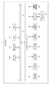
GPSロガー1は、第1CPU(Central Processing Unit)11aと、第2CPU11bと、ROM(Read Only Memory)12と、RAM(Random Access Memory)13と、バス14と、入出力インターフェース15と、測位部16と、入力部17と、出力部18と、センサ部19と、記憶部20と、通信部21と、ドライブ22と、電源管理部23と、を備えている。
The GPS logger 1 includes a first CPU (Central Processing Unit) 11a, a
第1CPU11aは、GPSロガー1全体の動作を制御し、ROM12に記録されているプログラム、または、記憶部20からRAM13にロードされたプログラムに従って各種の処理を実行する。
第2CPU11bは、後述する測位制御処理を実行することにより、GPS受信の間欠動作を主に制御する。第2CPU11bは、第1CPU11aよりも低クロック周波数で動作する低消費電力なハードウェアによって構成される。なお、第2CPU11bの機能をFPGA(Field‐Programmable Gate Array)やASIC(Application Specific Integrated Circuit)で実現することとしてもよい。
また、第1CPU11a及び第2CPU11bを単一のCPUで構成してもよい。
The
The
Further, the
RAM13には、第1CPU11aあるいは第2CPU11bが各種の処理を実行する上において必要なデータ等も適宜記憶される。
The
第1CPU11a、第2CPU11b、ROM12及びRAM13は、バス14を介して相互に接続されている。このバス14にはまた、入出力インターフェース15も接続されている。入出力インターフェース15には、測位部16、入力部17、出力部18、センサ部19、記憶部20、通信部21、ドライブ22及び電源管理部23が接続されている。
The
測位部16は、GPS受信器を備え、GPS衛星から受信したGPS信号に基づいて、GPSロガー1の位置(緯度、経度、高度)及びGPSによって示される現在時刻を検出する。また、測位部16は、検出した位置及び現在時刻を示す情報を第1CPU11aあるいは第2CPU11bに出力する。
The
入力部17は、各種釦等で構成され、ユーザの指示操作に応じて各種情報を入力する。
出力部18は、ディスプレイやスピーカ等で構成され、画像や音声を出力する。
センサ部19は、ジャイロセンサ、加速度センサ及び地磁気センサ等の各種センサを備え、GPSロガー1の姿勢、GPSロガー1の移動あるいは方位等を検出する。
The
The
The
記憶部20は、ハードディスクあるいはフラッシュメモリ等で構成され、第1CPU11aあるいは第2CPU11bが実行するプログラムや各種データ(GPSにおけるエフェメリスのデータや、GPSによる測位結果のデータ等)を記憶する。
通信部21は、インターネットを含むネットワークを介して他の装置(図示せず)との間で行う通信を制御する。また、通信部21は、Bluetooth等の近距離無線通信により他の装置との間で行う通信を制御する。
The
The
ドライブ22には、磁気ディスク、光ディスク、光磁気ディスク、あるいは半導体メモリ等よりなる、リムーバブルメディア31が適宜装着される。ドライブ22によってリムーバブルメディア31から読み出されたプログラムは、必要に応じて記憶部20にインストールされる。また、リムーバブルメディア31は、記憶部20に記憶されている画像のデータ等の各種データも、記憶部20と同様に記憶することができる。
電源管理部23は、GPSロガー1の電池残量を検出し、検出した電池残量を示す情報を第1CPU11a及び第2CPU11bに出力する。
A
The
次に、スマートフォン2のハードウェア構成について説明する。
図3は、本発明の一実施形態に係るスマートフォン2のハードウェアの構成を示すブロック図である。
スマートフォン2は、CPU111と、ROM112と、RAM113と、バス114と、入出力インターフェース115と、測位部116と、入力部117と、出力部118と、センサ部119と、記憶部120と、通信部121と、ドライブ122と、撮像部123と、を備えている。
Next, the hardware configuration of the
FIG. 3 is a block diagram illustrating a hardware configuration of the
The
これらのうち、撮像部123以外の構成については、図2に示すGPSロガー1の対応するハードウェア構成と同様である。
撮像部123は、図示はしないが、光学レンズ部と、イメージセンサと、を備えている。
Among these, the configuration other than the
Although not shown, the
光学レンズ部は、被写体を撮影するために、光を集光するレンズ、例えばフォーカスレンズやズームレンズ等で構成される。
フォーカスレンズは、イメージセンサの受光面に被写体像を結像させるレンズである。ズームレンズは、焦点距離を一定の範囲で自在に変化させるレンズである。
光学レンズ部にはまた、必要に応じて、焦点、露出、ホワイトバランス等の設定パラメータを調整する周辺回路が設けられる。
The optical lens unit is configured by a lens that collects light, for example, a focus lens or a zoom lens, in order to photograph a subject.
The focus lens is a lens that forms a subject image on the light receiving surface of the image sensor. The zoom lens is a lens that freely changes the focal length within a certain range.
The optical lens unit is also provided with a peripheral circuit for adjusting setting parameters such as focus, exposure, and white balance as necessary.
イメージセンサは、光電変換素子や、AFE(Analog Front End)等から構成される。
光電変換素子は、例えばCMOS(Complementary Metal Oxide Semiconductor)型の光電変換素子等から構成される。光電変換素子には、光学レンズ部から被写体像が入射される。そこで、光電変換素子は、被写体像を光電変換(撮像)して画像信号を一定時間蓄積し、蓄積した画像信号をアナログ信号としてAFEに順次供給する。
AFEは、このアナログの画像信号に対して、A/D(Analog/Digital)変換処理等の各種信号処理を実行する。各種信号処理によって、ディジタル信号が生成され、撮像部123の出力信号として出力される。
このような撮像部123の出力信号は、CPU111等に適宜供給される。
The image sensor includes a photoelectric conversion element, AFE (Analog Front End), and the like.
The photoelectric conversion element is composed of, for example, a CMOS (Complementary Metal Oxide Semiconductor) type photoelectric conversion element or the like. A subject image is incident on the photoelectric conversion element from the optical lens unit. Therefore, the photoelectric conversion element photoelectrically converts (captures) the subject image, accumulates the image signal for a predetermined time, and sequentially supplies the accumulated image signal as an analog signal to the AFE.
The AFE performs various signal processing such as A / D (Analog / Digital) conversion processing on the analog image signal. Through various signal processing, a digital signal is generated and output as an output signal of the
Such an output signal of the
[機能的構成]
図4は、このようなGPSロガー1及びスマートフォン2の機能的構成のうち、測位制御処理を実行するための機能的構成を示す機能ブロック図である。
測位制御処理とは、スマートフォン2からエフェメリスデータを取得し、そのエフェメリスデータを利用することにより、GPS信号を間欠的に受信して短時間測位(Hot Start)を行う一連の処理をいう。なお、測位制御処理が実行される場合、スマートフォン2の測位機能は、常時の測位は行わない(即ち、OFFまたは必要な場合にのみ測位する)状態とされ、消費電力の低減が図られる。
[Functional configuration]
FIG. 4 is a functional block diagram showing a functional configuration for executing the positioning control process among the functional configurations of the GPS logger 1 and the
The positioning control process refers to a series of processes in which ephemeris data is acquired from the
測位制御処理が実行される場合には、図4に示すように、GPSロガー1の第2CPU11bにおいて、静止判定部51と、電池残量判定部52と、エフェメリス要求部53と、GPS受信制御部54と、状態設定部55とが機能する。また、GPSロガー1の第1CPU11aにおいて、タイマ部61と、起動通知部62とが機能する。さらに、スマートフォン2のCPU111において、エフェメリス取得部151と、フォーマット変換部152と、エフェメリス送信部153とが機能する。
また、GPSロガー1の記憶部20の一領域には、GPSログ記憶部71と、エフェメリスデータ記憶部72とが設定される。
GPSログ記憶部71には、GPS測位によって取得された位置のデータが記憶される。
エフェメリスデータ記憶部72には、スマートフォン2から取得したエフェメリスデータあるいはGPS信号を受信することにより取得したエフェメリスデータが記憶される。
When the positioning control process is executed, as shown in FIG. 4, in the
A GPS log storage unit 71 and an ephemeris data storage unit 72 are set in one area of the
The GPS log storage unit 71 stores position data acquired by GPS positioning.
The ephemeris data storage unit 72 stores ephemeris data acquired from the
静止判定部51は、センサ部19の検出結果に基づいて、GPSロガー1が静止しているか否かを判定する。例えば、静止判定部51は、センサ部19のジャイロセンサ及び加速度センサの検出結果が予め設定された値以下の状態が設定された時間以上継続している場合に、GPSロガー1が静止していると判定する。
電池残量判定部52は、電源管理部23から入力される電池残量を示す情報に基づいて、電池残量が設定された閾値よりも少ないか否かを判定する。
The
The remaining battery
エフェメリス要求部53は、スマートフォン2に対して、GPS測位に用いるエフェメリスデータを要求する。このとき、エフェメリス要求部53は、予め設定されている要求条件を判定し、判定結果に応じて、要求するエフェメリスデータの数を変更する。
具体的には、エフェメリス要求部53は、
(1)スマートフォン2による現在位置の特定が可能か否か
(2)直近のGPS測位の結果から現在位置の特定が可能か否か
(3)現在位置が公園等の見晴らしが良い場所か否か(即ち、受信環境が良好であるか否か)
(4)GPSのアンテナが天空を向いた状態か否か
の各条件に応じて、
(A)エフェメリス有効期間(例えば4時間)内に捕捉可能な中仰角(例えば45度)以上にあるGPS衛星のエフェメリスデータのみを要求する
(B)エフェメリス有効期間内に捕捉可能な全てのGPS衛星のエフェメリスデータのみを要求する
(C)全てのGPS衛星のエフェメリスデータを要求する
のいずれかの要求内容を切り換える。
The
Specifically, the
(1) Whether the current position can be identified by the smartphone 2 (2) Whether the current position can be identified from the results of the latest GPS positioning (3) Whether the current position is a place with a good view of a park or the like (That is, whether the reception environment is good)
(4) Depending on whether each GPS antenna is facing the sky or not,
(A) Requests only ephemeris data of GPS satellites at a medium elevation angle (for example, 45 degrees) or more that can be captured within the ephemeris effective period (for example, 4 hours). (B) All GPS satellites that can be captured within the ephemeris effective period. (E) requesting only ephemeris data of (C) requesting ephemeris data of all GPS satellites.
例えば、エフェメリス要求部53は、条件(1)が充足されず、条件(2)も充足されない場合、(C)の要求内容を実行する。
また、エフェメリス要求部53は、条件(1)、(3)及び(4)が全て充足された場合、(A)の要求内容を実行する。
また、エフェメリス要求部53は、これら以外の場合に、(B)の要求内容を実行する。
このように、要求するエフェメリスデータの数を変更した結果、測位部16においてGPS測位が行われる際に動作するサーチエンジン及びトラッキングエンジンの数が変化される。なお、サーチエンジンとは、GPS衛星からの信号を検出する回路(衛星捕捉動作を行う回路)である。また、トラッキングエンジンとは、サーチエンジンにより検出された信号の同期を維持し、航法メッセージのデコードや衛星から受信機までの遅延時間(疑似距離)等を求める回路(衛星追尾動作を行う回路)である。
For example, when the condition (1) is not satisfied and the condition (2) is not satisfied, the
Further, the
In addition, the
As described above, as a result of changing the number of requested ephemeris data, the number of search engines and tracking engines that are operated when GPS positioning is performed in the
例えば、GPS測位に用いるエフェメリスデータの数が16衛星分であれば、GPS測位の際に動作させるサーチエンジン数及びトラッキングエンジン数を16チャネル分とする。また、GPS測位に用いるエフェメリスデータの数が6衛星分であれば、GPS測位の際に動作させるサーチエンジン数及びトラッキングエンジン数を6チャネル分とする。
このように、GPS測位に用いるエフェメリスデータの数を異ならせることにより、GPS測位の際のサーチエンジン数及びトラッキングエンジン数を変化させて、より低消費電力にGPS測位を行うことが可能となる。
For example, if the number of ephemeris data used for GPS positioning is 16 satellites, the number of search engines and the number of tracking engines to be operated at the time of GPS positioning are set to 16 channels. Further, if the number of ephemeris data used for GPS positioning is for 6 satellites, the number of search engines and the number of tracking engines to be operated at the time of GPS positioning are set to 6 channels.
Thus, by changing the number of ephemeris data used for GPS positioning, it is possible to change the number of search engines and the number of tracking engines during GPS positioning and perform GPS positioning with lower power consumption.
GPS受信制御部54は、測位部16におけるGPS信号の受信(GPS測位)を間欠的に実行する制御を行う。具体的には、GPS受信制御部54は、起動通知部62から起動通知信号が入力された場合に、GPS信号の受信を実行する。なお、GPS受信制御部54は、入力部17からGPS受信を指示する入力が行われた場合には、GPS信号の受信を実行する。
本実施形態において、GPS受信制御部54は、スマートフォン2からエフェメリスデータを受信することにより、長いインターバル(ここでは120分)で短時間測位(Hot Start)を行うことが可能となっている。
The GPS
In the present embodiment, the GPS
状態設定部55は、GPS信号を間欠的に受信するインターバルを設定すると共に、GPS信号の受信時におけるGPSロガー1の状態(Bluetoothによる通信のON/OFF等)を設定する。
タイマ部61は、状態設定部55によってGPS信号を間欠的に受信するインターバルが設定された場合に、次回のGPS信号の受信までの時間を計測する。
起動通知部62は、タイマ部61の計測結果を参照し、次回のGPS信号の受信までの時間が経過した場合に、第2CPU11bにGPS信号の受信タイミングであることを通知する起動通知信号を出力する。
The
When the interval for intermittently receiving the GPS signal is set by the
The
エフェメリス取得部151は、携帯電話の基地局等からエフェメリスデータを取得する。このエフェメリスデータは、例えば、A−GPS(Assisted Global Positioning System)のアシストデータの中から抽出すること等ができる。
The
フォーマット変換部152は、エフェメリス取得部151によって取得されたエフェメリスデータのフォーマットをGPSロガー1において利用可能な形式に変換する。
エフェメリス送信部153は、フォーマット変換部152によってフォーマット変換されたエフェメリスデータを、Bluetooth等の近距離無線通信を介してGPSロガー1に送信する。
The
The
[動作]
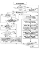
次に、GPS受信システムSの動作を説明する。
図5は、図4の機能的構成を有する図1のGPSロガー1及びスマートフォン2が実行する測位制御処理の流れを説明するフローチャートである。
測位制御処理は、ユーザによる入力部17への測位制御処理開始の操作により開始される。
[Operation]
Next, the operation of the GPS receiving system S will be described.
FIG. 5 is a flowchart for explaining the flow of positioning control processing executed by the GPS logger 1 and the
The positioning control process is started by an operation of starting the positioning control process on the
ステップS11において、静止判定部51は、GPSロガー1が静止状態であるか否かを判定する。
GPSロガー1が静止状態である場合、ステップS11においてYESと判定されて、処理はステップS12に移行する。
一方、GPSロガー1が静止状態でない場合、ステップS11においてNOと判定されて、処理はステップS13に移行する。
In step S11, the
When the GPS logger 1 is in a stationary state, YES is determined in step S11, and the process proceeds to step S12.
On the other hand, if the GPS logger 1 is not stationary, NO is determined in step S11, and the process proceeds to step S13.
ステップS12において、エフェメリス要求部53は、エフェメリスデータの要求を停止する。即ち、GPSロガー1が静止している状態が継続している限り、位置の変化がないことから、GPS測位は行われない。ステップS12の後、処理はステップS11に移行する。
In step S12, the
ステップS13において、電池残量判定部52は、電池残量が設定された閾値よりも少ないか否かを判定する。
電池残量が設定された閾値よりも少ない場合、ステップS13においてYESと判定されて、処理はステップS14に移行する。
一方、電池残量が設定された閾値以上である場合には、ステップS13においてNOと判定されて、処理はステップS20に移行する。
In step S <b> 13, the remaining battery
If the remaining battery level is less than the set threshold, YES is determined in step S13, and the process proceeds to step S14.
On the other hand, when the remaining battery level is equal to or greater than the set threshold value, NO is determined in step S13, and the process proceeds to step S20.
ステップS14において、エフェメリス要求部53は、スマートフォン2による現在位置の特定が可能か否かを判定する。
スマートフォン2による現在位置の特定が可能である場合、ステップS14においてYESと判定されて、処理はステップS16に移行する。
一方、スマートフォン2による現在位置の特定が可能でない場合には、ステップS14においてNOと判定されて、処理はステップS15に移行する。
In step S <b> 14, the
If the current position can be specified by the
On the other hand, when the current position cannot be specified by the
ステップS15において、エフェメリス要求部53は、直近のGPS測位の結果から現在位置の特定が可能か否かを判定する。
直近のGPS測位の結果から現在位置の特定が可能である場合には、ステップS15においてYESと判定されて、処理はステップS19に移行する。
一方、直近のGPS測位の結果から現在位置の特定が可能かでない場合には、ステップS15においてNOと判定されて、処理はステップS20に移行する。
In step S15, the
If the current position can be specified from the latest GPS positioning result, YES is determined in step S15, and the process proceeds to step S19.
On the other hand, if it is not possible to identify the current position from the result of the latest GPS positioning, NO is determined in step S15, and the process proceeds to step S20.
ステップS16において、エフェメリス要求部53は、現在位置が公園等の見晴らしの良い場所か否かを判定する。このとき、エフェメリス要求部53は、スマートフォン2に記憶されている地図情報あるいはスマートフォン2を介してダウンロードした地図情報等を参照して、現在位置が見晴らしの良い場所か否かを判定することができる。
現在位置が公園等の見晴らしの良い場所である場合、ステップS16においてYESと判定されて、処理はステップS17に移行する。
一方、現在位置が公園等の見晴らしの良い場所でない場合、ステップS16においてNOと判定されて、処理はステップS19に移行する。
In step S16, the
If the current position is a place with a good view such as a park, YES is determined in step S16, and the process proceeds to step S17.
On the other hand, if the current position is not a place with a good view, such as a park, NO is determined in step S16, and the process proceeds to step S19.
ステップS17において、エフェメリス要求部53は、GPSのアンテナが天空を向いた状態であるか否かを判定する。
GPSのアンテナが天空を向いた状態である場合、ステップS17においてYESと判定されて、処理はステップS18に移行する。
一方、GPSのアンテナが天空を向いた状態でない場合、ステップS17においてNOと判定されて、処理はステップS19に移行する。
In step S17, the
If the GPS antenna is facing the sky, YES is determined in step S17, and the process proceeds to step S18.
On the other hand, if the GPS antenna is not facing the sky, NO is determined in step S17, and the process proceeds to step S19.
ステップS18において、エフェメリス要求部53は、エフェメリスデータの有効期間内に捕捉可能な中仰角以上にあるGPS衛星のエフェメリスデータをスマートフォン2に要求する。
ステップS18の後、処理はステップS20に移行する。
ステップS19において、エフェメリス要求部53は、エフェメリス有効期間内に捕捉可能な全てのGPS衛星のエフェメリスデータをスマートフォン2に要求する。
In step S <b> 18, the
After step S18, the process proceeds to step S20.
In step S19, the
ステップS20において、エフェメリス要求部53は、全てのGPS衛星のエフェメリスデータをスマートフォン2に要求する。
ステップS21において、エフェメリス送信部153は、GPSロガー1の要求に応じてエフェメリスデータを送信する。このとき送信されるエフェメリスデータは、ステップS18、S19及びS20のいずれかにおいて要求されたGPS衛星のエフェメリスデータをエフェメリス取得部151が取得し、フォーマット変換部152によってフォーマット変換されたものである。
In step S20, the
In step S <b> 21, the
ステップS22において、状態設定部55は、エフェメリスデータの受信完了後に、スマートフォン2との通信に用いた通信(ここではBluetoothであるものとする)をOFFする。
ステップS23において、GPS受信制御部54は、ステップS24において受信したエフェメリスデータを用いて測位部16におけるGPS測位を開始し、状態設定部55は、次回のGPS信号の受信(エフェメリスデータの更新)までのインターバルを設定する。このとき、上述のようにスマートフォン2から受信したエフェメリスデータを用いることから、GPSロガー1においては、長いインターバルでの短時間測位(Hot Start)を行うことが可能である。また、GPS測位に用いるエフェメリスデータの数に応じて、動作させるサーチエンジン数及びトラッキングエンジン数が変化するため、より低消費電力にGPS測位が行われる。
In step S <b> 22, the
In step S23, the GPS
ステップS24において、GPS受信制御部54は、GPS測位を停止し、タイマ部61は、次回のGPS信号の受信までの時間を計測(カウントダウン)する。
In step S24, the GPS
ステップS25において、状態設定部55は、入力部17からの操作等によりGPS測位の要求が行われることに対応して、GPS測位を開始し、短時間測位(Hot Start)を行う待機状態となる。GPS測位の要求が行われた場合、GPS測位の完了またはタイムアウトにより、状態設定部55は、GPS測位を停止する。
In step S25, the
ステップS26において、状態設定部55は、次のGPS信号の受信タイミングとなっているか否か(インターバルが経過したか否か)を判定する。具体的には、状態設定部55は、起動通知部62から起動通知信号が入力されたか否かを判定する。
次のGPS信号の受信タイミングとなっている場合、ステップS26においてYESと判定されて、処理はステップS11に移行する。
一方、次のGPS信号の受信タイミングとなっていない場合、ステップS26においてNOと判定されて、処理はステップS24に移行する。
In step S26, the
When it is the reception timing of the next GPS signal, YES is determined in step S26, and the process proceeds to step S11.
On the other hand, if the reception timing of the next GPS signal is not reached, NO is determined in step S26, and the process proceeds to step S24.
このような処理により、GPSロガー1においては、以下の効果を奏する。
即ち、短時間測位(Hot Start)によりGPS測位を行うためのエフェメリスデータを、スマートフォン等の携帯電話用に送信されるA−GPSデータ等から抽出し、フォーマット変換してGPSロガー1で利用できるようにしたことで、エフェメリスデータを実測で取得する場合に比べ、消費電力を削減しつつ、短時間測位を行うことが可能となる。
With such processing, the GPS logger 1 has the following effects.
That is, ephemeris data for performing GPS positioning by short-time positioning (Hot Start) is extracted from A-GPS data transmitted for mobile phones such as smartphones, and the like, so that it can be used by the GPS logger 1 after format conversion. As a result, it is possible to perform positioning for a short time while reducing power consumption, compared to the case where ephemeris data is acquired by actual measurement.
また、ユーザがエフェメリスデータの取得を意識することなく、電池残量に応じた数のエフェメリスデータが適応的に取得されることで、さらなる低消費電力化と利便性との両立を図ることができる。
また、実測でエフェメリスデータを取得する場合、実際に見えている衛星のエフェメリスデータを取得することとなるため、エフェメリスデータの更新(取得)後に出現した衛星については、短時間測位(Hot Start)でのGPS測位には使用できず、これにより測位精度に影響を及ぼすこととなる。一方、本発明においては、エフェメリスデータの更新後に出現したGPS衛星に対しても、エフェメリスデータが取得されるため、測位精度を向上させることができる。また、間欠的にGPS測位を行う際のインターバルをより長く設定することができる。
In addition, the user can adaptively acquire the number of ephemeris data corresponding to the remaining battery level without being aware of the acquisition of the ephemeris data, thereby achieving both lower power consumption and convenience. .
In addition, when acquiring ephemeris data by actual measurement, since ephemeris data of a satellite that is actually visible is acquired, satellites that appear after updating (acquisition) of ephemeris data are subjected to short-term positioning (Hot Start). Cannot be used for GPS positioning, and this affects positioning accuracy. On the other hand, in the present invention, since the ephemeris data is acquired even for the GPS satellite that appears after the update of the ephemeris data, the positioning accuracy can be improved. In addition, the interval for intermittent GPS positioning can be set longer.
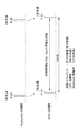
ここで、図6及び図7を用いて、本発明における電力削減効果の概要を説明する。
図6は、従来のGPSロガーにおいて、短時間測位を可能とした場合の間欠測位制御のシーケンスを表す模式図である。
また、図7は、本発明における短時間測位を行う場合の間欠測位制御のシーケンスを表す模式図である。
図6に示すように、従来のGPSロガーにおける間欠測位制御では、GPSロガーから見えているGPS衛星(例えば0個から12個)のエフェメリスデータのみを取得するものとして、約30分の間隔で約1〜3分間、GPS信号を受信しなければ短時間測位(Hot Start)に必要なエフェメリスデータを常に維持することができない。
Here, the outline of the power reduction effect in the present invention will be described with reference to FIGS. 6 and 7.
FIG. 6 is a schematic diagram showing a sequence of intermittent positioning control when short-time positioning is enabled in a conventional GPS logger.
FIG. 7 is a schematic diagram showing a sequence of intermittent positioning control when performing short-term positioning in the present invention.
As shown in FIG. 6, in the intermittent positioning control in the conventional GPS logger, it is assumed that only ephemeris data of GPS satellites (for example, 0 to 12) visible from the GPS logger is acquired, and about 30 minutes apart. If the GPS signal is not received for 1 to 3 minutes, the ephemeris data necessary for the short time positioning (Hot Start) cannot always be maintained.
この場合、従来のGPSロガーの平均消費電力は、GPS測位の消費電力を100mWと想定すると、
100mW×稼働率(3.3〜10%)=3.3mW〜10.0mW
となる。
一方、図7に示すように、本発明におけるGPSロガー1における間欠測位制御では、スマートフォン2からのエフェメリスデータの受信及びGPS信号の受信に要する消費電力が発生する。
1衛星あたりのエフェメリスデータは420Bitであるため、全32衛星のエフェメリスデータを受信したとすると、
420Bit×32衛星=13440Bit
となる。
In this case, the average power consumption of the conventional GPS logger is assumed that the power consumption of GPS positioning is 100 mW.
100 mW × operation rate (3.3 to 10%) = 3.3 mW to 10.0 mW
It becomes.
On the other hand, as shown in FIG. 7, in the intermittent positioning control in the GPS logger 1 according to the present invention, power consumption required for receiving the ephemeris data from the
Since the ephemeris data per satellite is 420 bits, if ephemeris data of all 32 satellites is received,
420 bits x 32 satellites = 13440 bits
It becomes.
Bluetoothの実質通信レートを400kbpsと想定すると、全32衛星のエフェメリスデータをスマートフォン2から受信するための通信時間は33.6ミリ秒となる。
なお、Bluetooth Low Energy(BLE)で通信を行った場合、実質通信レートを28.8kbpsと想定すると、全32衛星のエフェメリスデータをスマートフォン2から受信するための通信時間は、0.47秒となる。
したがって、全32衛星のエフェメリスデータをスマートフォン2から受信するのに要する時間は、各種レイテンシを含めて、1秒以下と仮定できる。
エフェメリスデータの更新(GPS信号の受信)間隔を120分に設定すると、
Bluetoothの稼働率は、
1秒/(120分×60秒)=0.014%
となる。
Assuming that the actual communication rate of Bluetooth is 400 kbps, the communication time for receiving ephemeris data of all 32 satellites from the
When communication is performed with Bluetooth Low Energy (BLE), assuming that the actual communication rate is 28.8 kbps, the communication time for receiving ephemeris data of all 32 satellites from the
Therefore, the time required to receive the ephemeris data of all 32 satellites from the
If the ephemeris data update (GPS signal reception) interval is set to 120 minutes,
The operation rate of Bluetooth is
1 second / (120 minutes × 60 seconds) = 0.014%
It becomes.
また、GPS測位の稼働率については、GPSの実質通信レートを90kbpsと想定すると、全32衛星のエフェメリスデータ(13440Bit)を受信するための通信時間は14.9ミリ秒となる。
したがって、全32衛星のエフェメリスデータの受信時間は各種レイテンシを含めて1秒以下と仮定できる。
エフェメリスデータの更新(GPS信号の受信)間隔を120分に設定すると、
GPS測位の稼働率は、
1秒/(120分×60秒)=0.014%
となる。
As for the operation rate of GPS positioning, assuming that the actual communication rate of GPS is 90 kbps, the communication time for receiving ephemeris data (13440 bits) of all 32 satellites is 14.9 milliseconds.
Therefore, the ephemeris data reception time of all 32 satellites can be assumed to be 1 second or less including various latencies.
If the ephemeris data update (GPS signal reception) interval is set to 120 minutes,
The operation rate of GPS positioning is
1 second / (120 minutes × 60 seconds) = 0.014%
It becomes.
この場合、GPSロガー1の平均消費電力は、Bluetoothによる通信の消費電力を50mW、GPS測位の消費電力を100mWと想定すると、
100mW×稼働率(0.014%)+50mW×稼働率(0.014%)=0.021mW
となる。
したがって、本発明におけるGPSロガー1では、短時間測位(Hot Sart)を維持するための電力削減率は少なくとも99.4〜99.8%となる。
なお、上述の計算では、全32衛星のエフェメリスデータをGPS測位に用いる場合を例に挙げているが、測位制御処理のステップS18,S19に示すように、より少ない数のGPS衛星を対象としてエフェメリスデータを取得する場合には、さらに消費電力を低減することができる。
In this case, assuming that the average power consumption of the GPS logger 1 is 50 mW for Bluetooth communication and 100 mW for GPS positioning,
100 mW × operation rate (0.014%) + 50 mW × operation rate (0.014%) = 0.021 mW
It becomes.
Therefore, in the GPS logger 1 according to the present invention, the power reduction rate for maintaining the short time positioning (Hot Start) is at least 99.4 to 99.8%.
In the above calculation, ephemeris data of all 32 satellites is used as an example for GPS positioning. However, as shown in steps S18 and S19 of the positioning control process, an ephemeris is targeted for a smaller number of GPS satellites. When acquiring data, power consumption can be further reduced.
以上のように構成されるGPSロガー1は、エフェメリス取得部151と、電源管理部23と、第2CPU11bと、測位部16と、を備える。
エフェメリス取得部151は、外部機器よりエフェメリスデータを取得可能に構成される。
電源管理部23は、電池残量を検出する。
第2CPU11bは、電源管理部23より検出された電池残量が予め定められた値より少ないか否かを判定する判定処理と、電池残量が予め定められた値より少ないと判定された場合に、現在位置おける測位衛星の受信状況に応じて、エフェメリス取得部151によるエフェメリスデータの取得を制御する制御処理と、を実行する。
測位部16は、エフェメリス取得部151により取得されたエフェメリスデータと測位衛星から受信したエフェメリスデータとに基づいて、現在位置を測位する。
これにより、電池残量及び測位衛星の受信状況に応じた数のエフェメリスデータが外部機器から適応的に取得される。
したがって、長いインターバルで間欠的に測位を行うことが可能になると共に、低消費電力で短時間測位を実現することが可能となる。
The GPS logger 1 configured as described above includes an
The
The
The
The
Thereby, the number of ephemeris data corresponding to the remaining battery level and the reception status of the positioning satellite is adaptively acquired from the external device.
Therefore, positioning can be intermittently performed at long intervals, and positioning can be realized in a short time with low power consumption.
第2CPU11bは、測位部16によるエフェメリスデータの受信動作を間欠的に起動する間欠制御処理を実行する。
測位部16は、エフェメリス取得部151により取得されたエフェメリスデータに基づいて、間欠制御処理によって起動されたエフェメリスデータの受信動作の際に、短時間測位による現在位置の測位を行う。
これにより、長いインターバルで間欠的に測位を行うことが可能になると共に、低消費電力で短時間測位を実現することが可能となる。
The
Based on the ephemeris data acquired by the
As a result, positioning can be intermittently performed at long intervals, and positioning can be achieved in a short time with low power consumption.
第2CPU11bは、制御処理において、電源管理部23により検出された電池残量が予め定められた値以上であると判定された場合は、全衛星のエフェメリスデータの取得を行うように、エフェメリス取得部151を制御する処理を実行する。
これにより、電池残量に余裕がある場合には、より高精度な測位を行うことが可能となる。
When it is determined in the control process that the remaining battery level detected by the
Thereby, when there is a margin in the remaining battery level, it is possible to perform more accurate positioning.
第2CPU11bは、制御処理において、地図情報に基づいて、現在位置が受信環境の良好な場所であるか否かをさらに判定し、受信環境に応じて、エフェメリス取得部151によるエフェメリスの取得を制御する処理を実行する。
これにより、より効率的に測位を行うことが可能となる。
In the control process, the
This makes it possible to perform positioning more efficiently.
第2CPU11bは、制御処理において、現在位置が受信環境の良好な場所にあると判定された場合に、測位部16の受信状況(アンテナの向き等)が良好な状態であるか否かを判定し、受信状況が良好な状態であると判定された場合は、エフェメリスデータの有効期間内に捕捉可能な所定の仰角以上の衛星のエフェメリスデータのみを取得する処理を実行する。
これにより、より効率的に測位を行うことが可能となる。
When it is determined in the control process that the current position is in a place with a good reception environment, the
This makes it possible to perform positioning more efficiently.
第2CPU11bは、制御処理において、現在位置がスマートフォン2によって特定可能であるか否かをさらに判定し、現在位置がスマートフォン2によって特定可能でないと判定された場合は、直近の測位の結果から現在位置の特定が可能であるか否かを判定し、直近の測位の結果から現在位置の特定が可能でないと判定された場合は、全衛星のエフェメリスデータを取得する処理を実行する。
これにより、全衛星のエフェメリスデータを取得する状況を抑制し、より効率的に測位を行うことが可能となる。
In the control process, the
As a result, the situation in which the ephemeris data of all satellites is acquired can be suppressed, and positioning can be performed more efficiently.
第2CPU11bは、制御処理において、直近の測位の結果から現在位置の特定が可能であると判定された場合は、エフェメリスデータの有効期間内に捕捉可能な衛星のエフェメリスデータのみを取得する処理を実行する。
これにより、より効率的に測位を行うことが可能となる。
When it is determined in the control process that the current position can be specified from the result of the latest positioning, the
This makes it possible to perform positioning more efficiently.
第2CPU11bは、制御処理において、現在位置が受信環境の良好な場所でないと判定された場合、または、測位部16の受信状況が良好な状態でないと判定された場合は、エフェメリスデータの有効期間内に捕捉可能な衛星のエフェメリスデータのみを取得する処理を実行する。
これにより、より効率的に測位を行うことが可能となる。
When the
This makes it possible to perform positioning more efficiently.
なお、本発明は、上述の実施形態に限定されるものではなく、本発明の目的を達成できる範囲での変形、改良等は本発明に含まれるものである。 In addition, this invention is not limited to the above-mentioned embodiment, The deformation | transformation in the range which can achieve the objective of this invention, improvement, etc. are included in this invention.
上述の実施形態では、GPSによって測位を行う場合を例に挙げて説明したが、これに限られない。即ち、本発明は、ロシアのGLONASS、欧州のGalileo、あるいは、中国のBeiDou等、衛星を利用した種々の測位システムに適用することができる。 In the above-described embodiment, the case where positioning is performed by GPS has been described as an example. That is, the present invention can be applied to various positioning systems using satellites, such as GLONASS in Russia, Galileo in Europe, or BeiDou in China.
また、上述の実施形態では、GPS測位を間欠的に行う際のインターバルを120分に設定するものとして説明したが、これに限られない。即ち、GPS測位を間欠的に行う際のインターバルは、消費電力の削減度合いやGPS信号の受信状況等に応じて、適宜設定することができる。
また、上述の実施形態では、電池残量が設定された閾値よりも少ない場合に、スマートフォン2に要求するエフェメリスデータの数を減少させることとして説明したが、これに限られない。即ち、電池残量が設定された閾値以上であり、電池残量に余裕がある場合であっても、スマートフォン2に要求するエフェメリスデータの数を減少させる処理を実行してもよい。
Moreover, although the above-mentioned embodiment demonstrated as what sets the interval at the time of performing GPS positioning intermittently to 120 minutes, it is not restricted to this. That is, the interval for intermittently performing GPS positioning can be set as appropriate according to the degree of power consumption reduction, the reception status of GPS signals, and the like.
Moreover, although the above-mentioned embodiment demonstrated as reducing the number of ephemeris data requested | required of the
また、上述の実施形態では、本発明が適用されるGPSロガーを例として説明したが、特にこれに限定されない。
例えば、本発明は、測位機能を有する電子機器一般に適用することができる。具体的には、例えば、本発明は、デジタルカメラ、ウェアラブル端末装置、ノート型のパーソナルコンピュータ、プリンタ、テレビジョン受像機、ビデオカメラ、携帯型ナビゲーション装置、携帯電話機、スマートフォン、ポータブルゲーム機等に適用可能である。
Moreover, although the above-mentioned embodiment demonstrated as an example the GPS logger to which this invention is applied, it is not limited to this in particular.
For example, the present invention can be applied to general electronic devices having a positioning function. Specifically, for example, the present invention is applied to a digital camera, a wearable terminal device, a notebook personal computer, a printer, a television receiver, a video camera, a portable navigation device, a mobile phone, a smartphone, a portable game machine, and the like. Is possible.
上述した一連の処理は、ハードウェアにより実行させることもできるし、ソフトウェアにより実行させることもできる。
換言すると、図4の機能的構成は例示に過ぎず、特に限定されない。即ち、上述した一連の処理を全体として実行できる機能がGPSロガー1に備えられていれば足り、この機能を実現するためにどのような機能ブロックを用いるのかは特に図4の例に限定されない。
また、1つの機能ブロックは、ハードウェア単体で構成してもよいし、ソフトウェア単体で構成してもよいし、それらの組み合わせで構成してもよい。
The series of processes described above can be executed by hardware or can be executed by software.
In other words, the functional configuration of FIG. 4 is merely an example, and is not particularly limited. That is, it is sufficient that the GPS logger 1 has a function capable of executing the above-described series of processing as a whole, and what functional blocks are used to realize this function is not particularly limited to the example of FIG.
In addition, one functional block may be constituted by hardware alone, software alone, or a combination thereof.
一連の処理をソフトウェアにより実行させる場合には、そのソフトウェアを構成するプログラムが、コンピュータ等にネットワークや記録媒体からインストールされる。
コンピュータは、専用のハードウェアに組み込まれているコンピュータであってもよい。また、コンピュータは、各種のプログラムをインストールすることで、各種の機能を実行することが可能なコンピュータ、例えば汎用のパーソナルコンピュータであってもよい。
When a series of processing is executed by software, a program constituting the software is installed on a computer or the like from a network or a recording medium.
The computer may be a computer incorporated in dedicated hardware. The computer may be a computer capable of executing various functions by installing various programs, for example, a general-purpose personal computer.
このようなプログラムを含む記録媒体は、ユーザにプログラムを提供するために装置本体とは別に配布される図1のリムーバブルメディア31により構成されるだけでなく、装置本体に予め組み込まれた状態でユーザに提供される記録媒体等で構成される。リムーバブルメディア31は、例えば、磁気ディスク(フロッピディスクを含む)、光ディスク、または光磁気ディスク等により構成される。光ディスクは、例えば、CD−ROM(Compact Disk−Read Only Memory),DVD(Digital Versatile Disk),Blu−ray(登録商標) Disc(ブルーレイディスク)等により構成される。光磁気ディスクは、MD(Mini−Disk)等により構成される。また、装置本体に予め組み込まれた状態でユーザに提供される記録媒体は、例えば、プログラムが記録されている図2のROM12や、図2の記憶部20に含まれるハードディスク等で構成される。
The recording medium including such a program is not only constituted by the
なお、本明細書において、記録媒体に記録されるプログラムを記述するステップは、その順序に沿って時系列的に行われる処理はもちろん、必ずしも時系列的に処理されなくとも、並列的あるいは個別に実行される処理をも含むものである。
また、本明細書において、システムの用語は、複数の装置や複数の手段等より構成される全体的な装置を意味するものとする。
In the present specification, the step of describing the program recorded on the recording medium is not limited to the processing performed in chronological order according to the order, but is not necessarily performed in chronological order, either in parallel or individually. The process to be executed is also included.
Further, in the present specification, the term “system” means an overall apparatus configured by a plurality of devices, a plurality of means, and the like.
以上、本発明のいくつかの実施形態について説明したが、これらの実施形態は、例示に過ぎず、本発明の技術的範囲を限定するものではない。本発明はその他の様々な実施形態を取ることが可能であり、さらに、本発明の要旨を逸脱しない範囲で、省略や置換等種々の変更を行うことができる。これら実施形態やその変形は、本明細書等に記載された発明の範囲や要旨に含まれると共に、特許請求の範囲に記載された発明とその均等の範囲に含まれる。 As mentioned above, although several embodiment of this invention was described, these embodiment is only an illustration and does not limit the technical scope of this invention. The present invention can take other various embodiments, and various modifications such as omission and replacement can be made without departing from the gist of the present invention. These embodiments and modifications thereof are included in the scope and gist of the invention described in this specification and the like, and are included in the invention described in the claims and the equivalents thereof.
以下に、本願の出願当初の特許請求の範囲に記載された発明を付記する。
[付記1]
外部機器より測位用の衛星情報を取得可能な取得部と、
電池残量を検出する電池残量検出部と、
前記電池残量検出部により検出された電池残量が予め定められた値より少ないか否かを判定する判定処理と、前記電池残量が予め定められた値より少ないと判定された場合に、現在位置おける測位衛星の受信状況に応じて、前記取得部による前記測位用の衛星情報の取得を制御する制御処理と、を実行する処理部と、
前記取得部により取得された前記測位用の衛星情報と前記測位衛星から受信した前記測位用の衛星情報とに基づいて、現在位置を測位する測位部と、
を備えることを特徴とする測位装置。
[付記2]
前記処理部は、前記測位部による前記測位用の衛星情報の受信動作を間欠的に起動する間欠制御処理を実行し、
前記測位部は、前記取得部により取得された前記測位用の衛星情報に基づいて、前記間欠制御処理によって起動された前記測位用の衛星情報の受信動作の際に、短時間測位による現在位置の測位を行うことを特徴とする付記1に記載の測位装置。
[付記3]
前記処理部は、前記制御処理において、前記電池残量検出部により検出された電池残量が予め定められた値以上であると判定された場合は、全衛星の前記測位用の衛星情報の取得を行うように、前記取得部を制御する処理を実行する、
ことを特徴とする付記1または2に記載の測位装置。
[付記4]
前記処理部は、前記制御処理において、地図情報に基づいて、前記現在位置が受信環境の良好な場所であるか否かをさらに判定し、前記受信環境に応じて、前記取得部による前記測位用の衛星情報の取得を制御する処理を実行する、
ことを特徴とする付記1から3のいずれか1つに記載の測位装置。
[付記5]
前記処理部は、前記制御処理において、前記現在位置が受信環境の良好な場所であると判定された場合に、前記測位部の受信状況が良好な状態であるか否かを判定し、前記受信状況が良好な状態であると判定された場合は、前記測位用の衛星情報の有効期間内に捕捉可能な所定の仰角以上の衛星の前記測位用の衛星情報のみを取得する処理を実行する、
ことを特徴とする付記4に記載の測位装置。
[付記6]
前記処理部は、前記制御処理において、前記現在位置が前記外部機器によって特定可能であるか否かをさらに判定し、前記現在位置が前記外部機器によって特定可能でないと判定された場合は、直近の測位の結果から現在位置の特定が可能であるか否かを判定し、直近の測位の結果から現在位置の特定が可能でないと判定された場合は、全衛星の前記測位用の衛星情報を取得する処理を実行する、
ことを特徴とする付記1から5のいずれか1つに記載の測位装置。
[付記7]
前記処理部は、前記制御処理において、直近の測位の結果から現在位置の特定が可能であると判定された場合は、前記測位用の衛星情報の有効期間内に捕捉可能な衛星の前記測位用の衛星情報のみを取得する処理を実行する、
ことを特徴とする付記6に記載の測位装置。
[付記8]
前記処理部は、前記制御処理において、前記現在位置が受信環境の良好な場所でないと判定された場合、または、前記測位部の受信状況が良好な状態でないと判定された場合は、前記測位用の衛星情報の有効期間内に捕捉可能な衛星の前記測位用の衛星情報のみを取得する処理を実行する、
ことを特徴とする付記5に記載の測位装置。
[付記9]
外部機器より測位用の衛星情報を取得可能な取得部と、電池残量を検出する電池残量検出部と、前記取得部により取得された前記測位用の衛星情報と測位衛星から受信した前記測位用の衛星情報とに基づいて、現在位置を測位する測位部と、処理部と、を有する測位装置で用いられる測位制御方法であって、前記処理部は、
前記電池残量検出部により検出された電池残量が予め定められた値より少ないか否かを判定し、
前記電池残量が予め定められた値より少ないと判定された場合に、現在位置おける前記測位衛星の受信状況に応じて、前記取得部による前記測位用の衛星情報の取得を制御する、
ことを特徴とする測位制御方法。
[付記10]
外部機器より測位用の衛星情報を取得可能な取得部と、電池残量を検出する電池残量検出部と、前記取得部により取得された前記測位用の衛星情報と測位衛星から受信した前記測位用の衛星情報とに基づいて、現在位置を測位する測位部と、処理部と、を有する測位装置として用いられるコンピュータに、
前記電池残量検出部により検出された電池残量が予め定められた値より少ないか否かを判定するステップと、
前記電池残量が予め定められた値より少ないと判定された場合に、現在位置おける前記測位衛星の受信状況に応じて、前記取得部による前記測位用の衛星情報の取得を制御するステップと、
を実行させるプログラム。
The invention described in the scope of claims at the beginning of the filing of the present application will be appended.
[Appendix 1]
An acquisition unit capable of acquiring satellite information for positioning from an external device;
A battery level detector for detecting the remaining battery level;
When it is determined that the remaining battery level detected by the remaining battery level detection unit is less than a predetermined value, and when it is determined that the remaining battery level is less than a predetermined value, A control unit for controlling the acquisition of the satellite information for positioning by the acquisition unit according to the reception status of the positioning satellite at the current position;
Based on the positioning satellite information acquired by the acquisition unit and the positioning satellite information received from the positioning satellite, a positioning unit for positioning the current position;
A positioning device comprising:
[Appendix 2]
The processing unit performs an intermittent control process for intermittently starting the positioning satellite information reception operation by the positioning unit,
The positioning unit, based on the positioning satellite information acquired by the acquisition unit, in the receiving operation of the positioning satellite information activated by the intermittent control process, the current position by the short-time positioning The positioning apparatus according to appendix 1, wherein positioning is performed.
[Appendix 3]
The processing unit obtains the satellite information for positioning of all the satellites when it is determined in the control process that the remaining battery level detected by the remaining battery level detection unit is equal to or greater than a predetermined value. To perform a process of controlling the acquisition unit to perform
The positioning device according to
[Appendix 4]
In the control process, the processing unit further determines whether or not the current position is a place with a good reception environment based on map information, and determines the location for the positioning by the acquisition unit according to the reception environment. Execute processing to control the acquisition of satellite information
4. The positioning device according to any one of supplementary notes 1 to 3, wherein
[Appendix 5]
In the control process, the processing unit determines whether the reception status of the positioning unit is in a good state when it is determined that the current position is a place with a good reception environment, and the reception When it is determined that the situation is in a good state, a process of acquiring only the satellite information for positioning of satellites having a predetermined elevation angle or higher that can be captured within the effective period of the satellite information for positioning is executed.
The positioning device according to supplementary note 4, characterized by:
[Appendix 6]
The processing unit further determines whether or not the current position can be specified by the external device in the control process, and if it is determined that the current position cannot be specified by the external device, It is determined whether the current position can be specified from the positioning result, and if it is determined from the latest positioning result that the current position cannot be specified, the satellite information for the positioning of all the satellites is acquired. Execute the process to
The positioning device according to any one of supplementary notes 1 to 5, characterized in that:
[Appendix 7]
In the control process, when it is determined in the control process that the current position can be specified from the result of the latest positioning, the processing unit is used for the positioning of the satellite that can be captured within the effective period of the positioning satellite information. Execute the process to acquire only the satellite information of
The positioning device according to supplementary note 6, wherein
[Appendix 8]
In the control process, when the current position is determined not to be a good location in the reception environment, or when it is determined that the reception status of the positioning part is not good in the control process, the processing unit A process of acquiring only the satellite information for positioning of the satellites that can be captured within the valid period of the satellite information of
The positioning device according to appendix 5, characterized in that:
[Appendix 9]
An acquisition unit that can acquire satellite information for positioning from an external device, a battery remaining amount detection unit that detects a remaining battery level, and the positioning satellite information acquired by the acquisition unit and the positioning received from the positioning satellite A positioning control method used in a positioning device having a positioning unit that measures a current position based on satellite information for use, and a processing unit, wherein the processing unit includes:
Determining whether or not the remaining battery level detected by the remaining battery level detection unit is less than a predetermined value;
When it is determined that the remaining battery level is less than a predetermined value, according to the positioning satellite reception status at the current position, control acquisition of the positioning satellite information by the acquisition unit,
A positioning control method characterized by that.
[Appendix 10]
An acquisition unit that can acquire satellite information for positioning from an external device, a battery remaining amount detection unit that detects a remaining battery level, and the positioning satellite information acquired by the acquisition unit and the positioning received from the positioning satellite Based on the satellite information for, a computer used as a positioning device having a positioning unit for positioning the current position, and a processing unit,
Determining whether the remaining battery level detected by the remaining battery level detection unit is less than a predetermined value;
When it is determined that the remaining battery level is less than a predetermined value, according to the reception status of the positioning satellite at the current position, controlling the acquisition of the positioning satellite information by the acquisition unit;
A program that executes
S・・・GPS受信システム,1・・・GPSロガー,2・・・スマートフォン,11a・・・第1CPU,11b・・・第2CPU,12、112・・・ROM,13、113・・・RAM,14、114・・・バス,15、115・・・入出力インターフェース,16、116・・・測位部,17、117・・・入力部,18、118・・・出力部,19、119・・・センサ部,20、120・・・記憶部,21、121・・・通信部,22、122・・・ドライブ,23・・・電源管理部,31・・・リムーバブルメディア,51・・・静止判定部,52・・・電池残量判定部,53・・・エフェメリス要求部,54・・・GPS受信制御部,55・・・状態設定部,61・・・タイマ部,62・・・起動通知部,71・・・GPSログ記憶部,72・・・エフェメリスデータ記憶部,111・・・CPU,123・・・撮像部,151・・・エフェメリス取得部,152・・・フォーマット変換部,153・・・エフェメリス送信部
S ... GPS reception system, 1 ... GPS logger, 2 ... smart phone, 11a ... first CPU, 11b ... second CPU, 12, 112 ... ROM, 13, 113 ... RAM , 14, 114 ... bus, 15, 115 ... input / output interface, 16, 116 ... positioning unit, 17, 117 ... input unit, 18, 118 ... output unit, 19, 119 ..
Claims (10)
電池残量を検出する電池残量検出部と、
前記電池残量検出部により検出された電池残量が予め定められた値より少ないか否かを判定する判定処理と、前記電池残量が予め定められた値より少ないと判定された場合に、現在位置おける測位衛星の受信状況に応じて、前記取得部による前記測位用の衛星情報の取得を制御する制御処理と、を実行する処理部と、
前記取得部により取得された前記測位用の衛星情報と前記測位衛星から受信した前記測位用の衛星情報とに基づいて、現在位置を測位する測位部と、
を備えることを特徴とする測位装置。 An acquisition unit capable of acquiring satellite information for positioning from an external device;
A battery level detector for detecting the remaining battery level;
When it is determined that the remaining battery level detected by the remaining battery level detection unit is less than a predetermined value, and when it is determined that the remaining battery level is less than a predetermined value, A control unit for controlling the acquisition of the satellite information for positioning by the acquisition unit according to the reception status of the positioning satellite at the current position;
Based on the positioning satellite information acquired by the acquisition unit and the positioning satellite information received from the positioning satellite, a positioning unit for positioning the current position;
A positioning device comprising:
前記測位部は、前記取得部により取得された前記測位用の衛星情報に基づいて、前記間欠制御処理によって起動された前記測位用の衛星情報の受信動作の際に、短時間測位による現在位置の測位を行うことを特徴とする請求項1に記載の測位装置。 The processing unit performs an intermittent control process for intermittently starting the positioning satellite information reception operation by the positioning unit,
The positioning unit, based on the positioning satellite information acquired by the acquisition unit, in the receiving operation of the positioning satellite information activated by the intermittent control process, the current position by the short-time positioning The positioning device according to claim 1, wherein positioning is performed.
ことを特徴とする請求項1または2に記載の測位装置。 The processing unit obtains the satellite information for positioning of all the satellites when it is determined in the control process that the remaining battery level detected by the remaining battery level detection unit is equal to or greater than a predetermined value. To perform a process of controlling the acquisition unit to perform
The positioning device according to claim 1 or 2, wherein
ことを特徴とする請求項1から3のいずれか1項に記載の測位装置。 In the control process, the processing unit further determines whether or not the current position is a place with a good reception environment based on map information, and determines the location for the positioning by the acquisition unit according to the reception environment. Execute processing to control the acquisition of satellite information
The positioning device according to any one of claims 1 to 3, wherein
ことを特徴とする請求項4に記載の測位装置。 In the control process, the processing unit determines whether the reception status of the positioning unit is in a good state when it is determined that the current position is a place with a good reception environment, and the reception When it is determined that the situation is in a good state, a process of acquiring only the satellite information for positioning of satellites having a predetermined elevation angle or higher that can be captured within the effective period of the satellite information for positioning is executed.
The positioning device according to claim 4.
ことを特徴とする請求項1から5のいずれか1項に記載の測位装置。 The processing unit further determines whether or not the current position can be specified by the external device in the control process, and if it is determined that the current position cannot be specified by the external device, It is determined whether the current position can be specified from the positioning result, and if it is determined from the latest positioning result that the current position cannot be specified, the satellite information for the positioning of all the satellites is acquired. Execute the process to
The positioning device according to any one of claims 1 to 5, wherein:
ことを特徴とする請求項6に記載の測位装置。 In the control process, when it is determined in the control process that the current position can be specified from the result of the latest positioning, the processing unit is used for the positioning of the satellite that can be captured within the effective period of the positioning satellite information. Execute the process to acquire only the satellite information of
The positioning device according to claim 6.
ことを特徴とする請求項5に記載の測位装置。 In the control process, when the current position is determined not to be a good location in the reception environment, or when it is determined that the reception status of the positioning part is not good in the control process, the processing unit A process of acquiring only the satellite information for positioning of the satellites that can be captured within the valid period of the satellite information of
The positioning device according to claim 5.
前記電池残量検出部により検出された電池残量が予め定められた値より少ないか否かを判定し、
前記電池残量が予め定められた値より少ないと判定された場合に、現在位置おける前記測位衛星の受信状況に応じて、前記取得部による前記測位用の衛星情報の取得を制御する、
ことを特徴とする測位制御方法。 An acquisition unit that can acquire satellite information for positioning from an external device, a battery remaining amount detection unit that detects a remaining battery level, and the positioning satellite information acquired by the acquisition unit and the positioning received from the positioning satellite A positioning control method used in a positioning device having a positioning unit that measures a current position based on satellite information for use, and a processing unit, wherein the processing unit includes:
Determining whether or not the remaining battery level detected by the remaining battery level detection unit is less than a predetermined value;
When it is determined that the remaining battery level is less than a predetermined value, according to the positioning satellite reception status at the current position, control acquisition of the positioning satellite information by the acquisition unit,
A positioning control method characterized by that.
前記電池残量検出部により検出された電池残量が予め定められた値より少ないか否かを判定するステップと、
前記電池残量が予め定められた値より少ないと判定された場合に、現在位置おける前記測位衛星の受信状況に応じて、前記取得部による前記測位用の衛星情報の取得を制御するステップと、
を実行させるプログラム。 An acquisition unit that can acquire satellite information for positioning from an external device, a battery remaining amount detection unit that detects a remaining battery level, and the positioning satellite information acquired by the acquisition unit and the positioning received from the positioning satellite Based on the satellite information for, a computer used as a positioning device having a positioning unit for positioning the current position, and a processing unit,
Determining whether the remaining battery level detected by the remaining battery level detection unit is less than a predetermined value;
When it is determined that the remaining battery level is less than a predetermined value, according to the reception status of the positioning satellite at the current position, controlling the acquisition of the positioning satellite information by the acquisition unit;
A program that executes
Priority Applications (3)
| Application Number | Priority Date | Filing Date | Title |
|---|---|---|---|
| JP2015187400A JP2017062165A (en) | 2015-09-24 | 2015-09-24 | Positioning device, positioning control method and program |
| US15/244,155 US10254410B2 (en) | 2015-09-24 | 2016-08-23 | Positioning control method, positioning device and storage medium |
| CN201610842068.3A CN107024708B (en) | 2015-09-24 | 2016-09-22 | Positioning device, positioning control method, and program |
Applications Claiming Priority (1)
| Application Number | Priority Date | Filing Date | Title |
|---|---|---|---|
| JP2015187400A JP2017062165A (en) | 2015-09-24 | 2015-09-24 | Positioning device, positioning control method and program |
Related Child Applications (1)
| Application Number | Title | Priority Date | Filing Date |
|---|---|---|---|
| JP2020053998A Division JP6849123B2 (en) | 2020-03-25 | 2020-03-25 | Positioning device, positioning control method and program |
Publications (2)
| Publication Number | Publication Date |
|---|---|
| JP2017062165A true JP2017062165A (en) | 2017-03-30 |
| JP2017062165A5 JP2017062165A5 (en) | 2018-10-25 |
Family
ID=58408947
Family Applications (1)
| Application Number | Title | Priority Date | Filing Date |
|---|---|---|---|
| JP2015187400A Pending JP2017062165A (en) | 2015-09-24 | 2015-09-24 | Positioning device, positioning control method and program |
Country Status (3)
| Country | Link |
|---|---|
| US (1) | US10254410B2 (en) |
| JP (1) | JP2017062165A (en) |
| CN (1) | CN107024708B (en) |
Families Citing this family (3)
| Publication number | Priority date | Publication date | Assignee | Title |
|---|---|---|---|---|
| US10033901B1 (en) | 2017-06-27 | 2018-07-24 | Xerox Corporation | System and method for using a mobile camera as a copier |
| JP6724934B2 (en) * | 2018-01-19 | 2020-07-15 | カシオ計算機株式会社 | Electronic device, positioning control method and program |
| CN110504729B (en) * | 2019-09-02 | 2022-06-24 | 宁波唯嘉软件科技有限公司 | Lithium battery power supply method, storage medium and device |
Citations (5)
| Publication number | Priority date | Publication date | Assignee | Title |
|---|---|---|---|---|
| JP2004317298A (en) * | 2003-04-16 | 2004-11-11 | Seiko Epson Corp | Information terminal, location acquisition method of the terminal, program for exhibiting location acquisition function in the terminal, and information recording medium with recorded program for demonstrating location acquisition function in the terminal |
| JP2006078442A (en) * | 2004-09-13 | 2006-03-23 | Seiko Epson Corp | Positioning system, terminal device, and control program of terminal device |
| JP2011185891A (en) * | 2010-03-11 | 2011-09-22 | Ntt Docomo Inc | Mobile terminal and positioning method for the same |
| JP2014182119A (en) * | 2013-03-21 | 2014-09-29 | Casio Comput Co Ltd | Positioning processing device, positioning processing method and program |
| US20140292564A1 (en) * | 2013-04-01 | 2014-10-02 | Fitbit, Inc. | Portable biometric monitoring devices having location sensors |
Family Cites Families (8)
| Publication number | Priority date | Publication date | Assignee | Title |
|---|---|---|---|---|
| JP2001074826A (en) | 1999-09-08 | 2001-03-23 | Casio Comput Co Ltd | Positioning system |
| US6522636B1 (en) * | 1999-10-01 | 2003-02-18 | Motorola, Inc. | Satellite communications system and method with real-time power-based flow control |
| JP4254822B2 (en) * | 2006-08-25 | 2009-04-15 | 船井電機株式会社 | Positioning system and mobile terminal |
| JP2009270929A (en) * | 2008-05-07 | 2009-11-19 | Sony Corp | Navigation apparatus and method of acquiring ephemeris data |
| JP5251372B2 (en) | 2008-09-04 | 2013-07-31 | セイコーエプソン株式会社 | Electronic clock |
| US8325088B2 (en) * | 2009-02-04 | 2012-12-04 | Google Inc. | Mobile device battery management |
| JP5614548B2 (en) | 2011-10-06 | 2014-10-29 | セイコーエプソン株式会社 | Electronic clock |
| JP6155953B2 (en) * | 2013-08-13 | 2017-07-05 | カシオ計算機株式会社 | Information communication apparatus, information communication system, information communication method, and program |
-
2015
- 2015-09-24 JP JP2015187400A patent/JP2017062165A/en active Pending
-
2016
- 2016-08-23 US US15/244,155 patent/US10254410B2/en active Active
- 2016-09-22 CN CN201610842068.3A patent/CN107024708B/en active Active
Patent Citations (5)
| Publication number | Priority date | Publication date | Assignee | Title |
|---|---|---|---|---|
| JP2004317298A (en) * | 2003-04-16 | 2004-11-11 | Seiko Epson Corp | Information terminal, location acquisition method of the terminal, program for exhibiting location acquisition function in the terminal, and information recording medium with recorded program for demonstrating location acquisition function in the terminal |
| JP2006078442A (en) * | 2004-09-13 | 2006-03-23 | Seiko Epson Corp | Positioning system, terminal device, and control program of terminal device |
| JP2011185891A (en) * | 2010-03-11 | 2011-09-22 | Ntt Docomo Inc | Mobile terminal and positioning method for the same |
| JP2014182119A (en) * | 2013-03-21 | 2014-09-29 | Casio Comput Co Ltd | Positioning processing device, positioning processing method and program |
| US20140292564A1 (en) * | 2013-04-01 | 2014-10-02 | Fitbit, Inc. | Portable biometric monitoring devices having location sensors |
Also Published As
| Publication number | Publication date |
|---|---|
| CN107024708A (en) | 2017-08-08 |
| US10254410B2 (en) | 2019-04-09 |
| US20170090035A1 (en) | 2017-03-30 |
| CN107024708B (en) | 2020-06-16 |
Similar Documents
| Publication | Publication Date | Title |
|---|---|---|
| US9961214B2 (en) | Image shooting apparatus for adding information to image | |
| JP5861667B2 (en) | Information processing apparatus, imaging system, imaging apparatus, information processing method, and program | |
| US10935391B2 (en) | Electronic device for improving altitude measurement accuracy | |
| CN107024708B (en) | Positioning device, positioning control method, and program | |
| US11340249B2 (en) | Electronic device, calibration control method, and storage medium storing program | |
| JP6244789B2 (en) | GPS receiver, electronic timepiece, control method, and program | |
| US9965686B2 (en) | Image capture apparatus that identifies object, image capture control method, and storage medium | |
| JP6146464B2 (en) | Imaging apparatus, information acquisition apparatus, information acquisition system, transmission control method, information acquisition method, and program | |
| US11796685B2 (en) | Positioning control device | |
| JP6849123B2 (en) | Positioning device, positioning control method and program | |
| JP6641829B2 (en) | Positioning device, positioning method and program | |
| JP6947250B2 (en) | Electronic devices, positioning control methods and programs | |
| JP2015121437A (en) | Position information acquisition device, position information acquisition method, and program | |
| US10425581B2 (en) | Recording apparatus, control method of recording apparatus, and storage medium | |
| JP6519969B2 (en) | Position information acquisition apparatus, round information generation apparatus, position information acquisition method and program | |
| JP2018096746A (en) | Position specifying device, position specifying method, and program | |
| JP5773753B2 (en) | Imaging apparatus and control method | |
| JP2018025568A (en) | Receiving device, electronic clock, radio wave reception method, and program | |
| JP2015045580A (en) | Electronic apparatus | |
| JP2012160856A (en) | Imaging apparatus | |
| JP2011253001A (en) | Imaging apparatus, photographing method, and program |
Legal Events
| Date | Code | Title | Description |
|---|---|---|---|
| A521 | Request for written amendment filed |
Free format text: JAPANESE INTERMEDIATE CODE: A523 Effective date: 20180912 |
|
| A621 | Written request for application examination |
Free format text: JAPANESE INTERMEDIATE CODE: A621 Effective date: 20180912 |
|
| A131 | Notification of reasons for refusal |
Free format text: JAPANESE INTERMEDIATE CODE: A131 Effective date: 20190813 |
|
| A977 | Report on retrieval |
Free format text: JAPANESE INTERMEDIATE CODE: A971007 Effective date: 20190814 |
|
| A521 | Request for written amendment filed |
Free format text: JAPANESE INTERMEDIATE CODE: A523 Effective date: 20191008 |
|
| A131 | Notification of reasons for refusal |
Free format text: JAPANESE INTERMEDIATE CODE: A131 Effective date: 20200303 |
|
| A02 | Decision of refusal |
Free format text: JAPANESE INTERMEDIATE CODE: A02 Effective date: 20200915 |