JP2011075402A - Navigation system, navigation instrument, navigation server, and vicinity search method - Google Patents
Navigation system, navigation instrument, navigation server, and vicinity search method Download PDFInfo
- Publication number
- JP2011075402A JP2011075402A JP2009227084A JP2009227084A JP2011075402A JP 2011075402 A JP2011075402 A JP 2011075402A JP 2009227084 A JP2009227084 A JP 2009227084A JP 2009227084 A JP2009227084 A JP 2009227084A JP 2011075402 A JP2011075402 A JP 2011075402A
- Authority
- JP
- Japan
- Prior art keywords
- facility
- reference point
- building
- extracted
- floor
- Prior art date
- Legal status (The legal status is an assumption and is not a legal conclusion. Google has not performed a legal analysis and makes no representation as to the accuracy of the status listed.)
- Pending
Links
Images


Landscapes
- Traffic Control Systems (AREA)
- Mobile Radio Communication Systems (AREA)
- Management, Administration, Business Operations System, And Electronic Commerce (AREA)
- Instructional Devices (AREA)
- Navigation (AREA)
Abstract
Description
本発明は、ナビゲーションシステム、ナビゲーション装置、ナビゲーションサーバ、および、周辺検索方法に関する。 The present invention relates to a navigation system, a navigation device, a navigation server, and a surrounding search method.
従来から、ナビゲーションシステムにおいて、周辺の店舗等の施設を検索する際には、基準になる地点(例えば、現在地)から所定範囲に含まれることを条件として検索、表示するものが一般的である。 Conventionally, in a navigation system, when a facility such as a nearby store is searched, it is common to search and display it on the condition that it is included in a predetermined range from a reference point (for example, the current location).
例えば、特許文献1には、画面表示された地図中で施設等の検索を行う際に、現在地等から所定の領域を設定し、当該領域内に存在する施設等を表示することができる車載用ナビゲーションシステムに関する技術が開示されている。
For example, in
しかしながら、抽出された店舗等の施設の検索結果を利用する局面を考えると、例えば現在地が駅やビル等の建物内にいる場合には、同一建物内の店舗等のほうが移動しやすいと考えられ、一方、建物外の公道等にいる場合にはビルや駅等の建物にわざわざ入って移動するよりも建物に入らず移動できる場所のほうが移動しやすいことが考えられるが、従来のナビゲーションシステムにおいては、単に水平方向の距離において所定範囲に入るか否かに基づいて例えば最短距離となる施設等の検索を行っているにすぎない、という問題点を有していた。 However, considering the situation of using the search results for the extracted facilities such as stores, for example, if the current location is in a building such as a station or a building, it is considered that stores in the same building are easier to move. On the other hand, if you are on a public road outside the building, it may be easier to move to a place where you can move without entering the building than to move into a building such as a building or station. Has a problem that it is merely searching for a facility having the shortest distance based on whether or not it falls within a predetermined range at a horizontal distance.
本発明は、上記問題点に鑑みてなされたもので、基準となる地点が建物内の場合、優先的に当該建物内の店舗を検索するなど、屋内屋外を考慮した周辺検索をすることができるナビゲーションシステム、ナビゲーション装置、ナビゲーションサーバ、および、周辺検索方法を提供することを目的とする。 The present invention has been made in view of the above problems, and when a reference point is in a building, it is possible to perform a peripheral search considering indoors and outdoors, such as preferentially searching for a store in the building. It is an object of the present invention to provide a navigation system, a navigation device, a navigation server, and a peripheral search method.
このような目的を達成するため、本発明のナビゲーションシステムは、制御部と記憶部とを少なくとも備えたナビゲーションサーバ、および、制御部と出力部とを少なくとも備えたナビゲーション装置、を通信可能に接続したナビゲーションシステムであって、上記記憶部は、各施設について、当該施設の座標と、当該施設が存在する建物の建物IDと、当該施設が存在する当該建物のフロアのフロアIDと、を対応付けて記憶する施設情報記憶手段、を備え、上記ナビゲーションサーバの上記制御部は、上記ナビゲーション装置から送信される、基準地点の座標と、当該基準地点が存在する上記建物の上記建物IDと、当該基準地点が存在する当該建物の上記フロアの上記フロアIDと、を含む基準地点情報を受信する基準地点情報受信手段と、上記基準地点情報受信手段により受信された上記基準地点情報に含まれる上記基準地点の座標と、上記施設情報記憶手段に記憶された上記施設の上記座標と、を比較することにより、上記基準地点から所定の範囲内に存在する上記施設を抽出する周辺施設抽出手段と、上記周辺施設抽出手段により抽出された上記施設の上記座標、上記建物ID、および、上記フロアIDと、上記基準地点情報受信手段により受信された上記基準地点情報に含まれる上記基準地点の座標、上記建物ID、および、上記フロアIDと、を比較することにより、当該抽出された上記施設を評価し、評価値を生成する施設評価値生成手段と、上記施設評価値生成手段により生成された上記評価値に基づいて、上記周辺施設抽出手段により抽出された上記施設をソートした抽出施設リストを生成する抽出施設リスト生成手段と、上記抽出施設リスト生成手段により生成された上記抽出施設リストを上記ナビゲーション装置に送信する抽出施設リスト送信手段と、を備え、上記ナビゲーション装置の上記制御部は、上記基準地点情報を上記ナビゲーションサーバに送信する基準地点情報送信手段と、上記ナビゲーションサーバから送信される上記抽出施設リストを受信する抽出施設リスト受信手段と、上記抽出施設リスト受信手段により受信された上記抽出施設リストを上記出力部を介して出力させるリスト出力手段と、を備えたことを特徴とする。 In order to achieve such an object, the navigation system of the present invention connects a navigation server having at least a control unit and a storage unit, and a navigation device having at least a control unit and an output unit so that they can communicate with each other. In the navigation system, for each facility, the storage unit associates the coordinates of the facility, the building ID of the building where the facility exists, and the floor ID of the floor of the building where the facility exists. Facility information storage means for storing, wherein the control unit of the navigation server transmits the coordinates of the reference point, the building ID of the building where the reference point exists, and the reference point transmitted from the navigation device Reference point information receiver that receives reference point information including the floor ID of the floor of the building where the By comparing the coordinates of the reference point included in the reference point information received by the reference point information receiving means with the coordinates of the facility stored in the facility information storage means. The surrounding facility extracting means for extracting the facility existing within a predetermined range from the point, the coordinates of the facility, the building ID, the floor ID, and the reference point information extracted by the surrounding facility extracting means By comparing the coordinates of the reference point, the building ID, and the floor ID included in the reference point information received by the receiving means, the extracted facility is evaluated and an evaluation value is generated. And the facility extracted by the peripheral facility extracting unit based on the evaluation value generated by the facility evaluation value generating unit and the facility evaluation value generating unit. An extracted facility list generating means for generating a selected extracted facility list; and an extracted facility list transmitting means for transmitting the extracted facility list generated by the extracted facility list generating means to the navigation device. The control unit includes: reference point information transmitting means for transmitting the reference point information to the navigation server; extracted facility list receiving means for receiving the extracted facility list transmitted from the navigation server; and receiving the extracted facility list. List output means for outputting the extracted facility list received by the means via the output unit.
また、本発明のナビゲーションシステムは、上記記載のナビゲーションシステムにおいて、上記評価値は、上記基準地点からの距離、上記基準地点と同一の上記建物IDか否か、および、上記基準地点と同一の上記フロアIDか否か、に基づく評価値であることを特徴とする。 In the navigation system according to the present invention, the evaluation value is a distance from the reference point, whether the building ID is the same as the reference point, and the same reference point as the reference point. It is an evaluation value based on whether or not it is a floor ID.
また、本発明のナビゲーションシステムは、上記記載のナビゲーションシステムにおいて、上記施設評価値生成手段は、更に、上記基準地点から上記施設までの経路探索を行い、当該経路探索結果に基づいて移動コストを生成する移動コスト生成手段を備え、上記基準地点が上記建物内の場合には上記基準地点と同一の上記建物IDの上記施設の上記移動コストを下げるように制御し、一方、上記基準地点が建物外である場合には建物内の上記施設の上記移動コストを上げるように制御し、当該移動コストに基づいて、上記評価値を生成することを特徴とする。 In the navigation system of the present invention, the facility evaluation value generation means further performs a route search from the reference point to the facility, and generates a movement cost based on the route search result. If the reference point is inside the building, control is performed to lower the movement cost of the facility having the same building ID as the reference point, while the reference point is outside the building. In such a case, control is performed to increase the movement cost of the facility in the building, and the evaluation value is generated based on the movement cost.
また、本発明のナビゲーションシステムは、上記記載のナビゲーションシステムにおいて、上記リスト出力手段は、上記抽出施設リスト中の上記施設のうち上記基準地点と同一の上記建物IDである上記施設に対して同一の建物内に存在することを示す同一建物表示データを上記出力部を介して出力させることを特徴とする。 The navigation system according to the present invention is the navigation system described above, wherein the list output means is the same for the facility having the same building ID as the reference point among the facilities in the extracted facility list. The same building display data indicating that it is present in the building is output via the output unit.
また、本発明のナビゲーションシステムは、上記記載のナビゲーションシステムにおいて、上記リスト出力手段は、上記抽出施設リスト中の上記施設のうち上記基準地点と同一の上記建物IDである上記施設に対してフロアIDに基づくフロア表示データを上記出力部を介して出力させることを特徴とする。 In the navigation system according to the present invention, in the navigation system described above, the list output means is a floor ID for the facility having the same building ID as the reference point among the facilities in the extracted facility list. The floor display data based on is output through the output unit.
また、本発明のナビゲーションシステムは、上記記載のナビゲーションシステムにおいて、上記リスト出力手段は、上記抽出施設リスト中の上記施設のうち上記基準地点と同一の上記建物IDである上記施設に対して、上記基準地点から当該施設までの移動手段を示す移動手段表示データを上記出力部を介して出力させることを特徴とする。 The navigation system according to the present invention is the navigation system described above, wherein the list output means is configured for the facility having the same building ID as the reference point among the facilities in the extracted facility list. Moving means display data indicating moving means from the reference point to the facility is output via the output unit.
また、本発明のナビゲーション装置は、記憶部を少なくとも備えたナビゲーションサーバに通信可能に接続された、制御部と出力部とを少なくとも備えたナビゲーション装置であって、上記記憶部は、各施設について、当該施設の座標と、当該施設が存在する建物の建物IDと、当該施設が存在する当該建物のフロアのフロアIDと、を対応付けて記憶する施設情報記憶手段、を備え、上記制御部は、基準地点の座標と、当該基準地点が存在する上記建物の上記建物IDと、当該基準地点が存在する当該建物の上記フロアの上記フロアIDと、を含む基準地点情報を上記ナビゲーションサーバに送信する基準地点情報送信手段と、上記基準地点情報に含まれる上記基準地点の座標と、上記施設情報記憶手段に記憶された上記施設の上記座標と、を比較することにより、上記基準地点から所定の範囲内に存在する抽出された上記施設であって、当該抽出された上記施設の上記座標、上記建物ID、および、上記フロアIDと、上記基準地点情報に含まれる上記基準地点の座標、上記建物ID、および、上記フロアIDと、を比較することにより、生成された評価値に基づいて、ソートされた当該抽出された施設の抽出施設リストを、上記ナビゲーションサーバから受信する抽出施設リスト受信手段と、上記抽出施設リスト受信手段により受信された上記抽出施設リストを上記出力部を介して出力させるリスト出力手段と、を備えたことを特徴とする。 Further, the navigation device of the present invention is a navigation device including at least a control unit and an output unit that are communicably connected to a navigation server including at least a storage unit, and the storage unit is configured for each facility. A facility information storage unit that stores the coordinates of the facility, the building ID of the building in which the facility exists, and the floor ID of the floor of the building in which the facility exists, and the control unit includes: A reference for transmitting reference point information including the coordinates of the reference point, the building ID of the building where the reference point exists, and the floor ID of the floor of the building where the reference point exists to the navigation server Point information transmission means, coordinates of the reference point included in the reference point information, and the coordinates of the facility stored in the facility information storage means; By comparing the extracted coordinates of the facility, the building ID, the floor ID, and the reference point. By comparing the coordinates of the reference point included in the information, the building ID, and the floor ID, the extracted facility list of the extracted facilities sorted based on the generated evaluation value, Extracted facility list receiving means received from the navigation server, and list output means for outputting the extracted facility list received by the extracted facility list receiving means via the output unit.
また、本発明のナビゲーション装置は、出力部と制御部と記憶部とを少なくとも備えたナビゲーション装置であって、上記記憶部は、各施設について、当該施設の座標と、当該施設が存在する建物の建物IDと、当該施設が存在する当該建物のフロアのフロアIDと、を対応付けて記憶する施設情報記憶手段、を備え、上記制御部は、基準地点の座標と、当該基準地点が存在する上記建物の上記建物IDと、当該基準地点が存在する当該建物の上記フロアの上記フロアIDと、を含む基準地点情報を取得する基準地点情報取得手段と、上記基準地点情報取得手段により取得された上記基準地点情報に含まれる上記基準地点の座標と、上記施設情報記憶手段に記憶された上記施設の上記座標と、を比較することにより、上記基準地点から所定の範囲内に存在する上記施設を抽出する周辺施設抽出手段と、上記周辺施設抽出手段により抽出された上記施設の上記座標、上記建物ID、および、上記フロアIDと、上記基準地点情報取得手段により取得された上記基準地点情報に含まれる上記基準地点の座標、上記建物ID、および、上記フロアIDと、を比較することにより、当該抽出された上記施設を評価し、評価値を生成する施設評価値生成手段と、上記施設評価値生成手段により生成された上記評価値に基づいて、上記周辺施設抽出手段により抽出された上記施設をソートした抽出施設リストを生成する抽出施設リスト生成手段と、上記抽出施設リスト生成手段により生成された上記抽出施設リストを上記出力部を介して出力させるリスト出力手段と、を備えたことを特徴とする。 The navigation device of the present invention is a navigation device that includes at least an output unit, a control unit, and a storage unit, and the storage unit includes, for each facility, the coordinates of the facility and the building where the facility exists. A facility information storage unit that associates and stores a building ID and a floor ID of the floor of the building where the facility exists, and the control unit includes the coordinates of the reference point and the reference point where the reference point exists. Reference point information acquisition means for acquiring reference point information including the building ID of the building and the floor ID of the floor of the building where the reference point exists, and the reference point information acquisition means acquired by the reference point information acquisition means By comparing the coordinates of the reference point included in the reference point information with the coordinates of the facility stored in the facility information storage means, Acquired by the surrounding facility extracting means for extracting the facility existing in the surroundings, the coordinates of the facility extracted by the surrounding facility extracting means, the building ID, the floor ID, and the reference point information acquiring means. The facility evaluation value generation for evaluating the extracted facility and generating an evaluation value by comparing the coordinates of the reference point, the building ID, and the floor ID included in the reference point information. And an extracted facility list generating means for generating an extracted facility list in which the facilities extracted by the peripheral facility extracting means are sorted based on the evaluation value generated by the facility evaluation value generating means, and the extracted facility List output means for outputting the extracted facility list generated by the list generation means via the output unit.
また、本発明のナビゲーションサーバは、出力部を少なくとも備えたナビゲーション装置に通信可能に接続された、制御部と記憶部とを少なくとも備えたナビゲーションサーバであって、上記記憶部は、各施設について、当該施設の座標と、当該施設が存在する建物の建物IDと、当該施設が存在する当該建物のフロアのフロアIDと、を対応付けて記憶する施設情報記憶手段、を備え、上記制御部は、上記ナビゲーション装置から送信される、基準地点の座標と、当該基準地点が存在する上記建物の上記建物IDと、当該基準地点が存在する当該建物の上記フロアの上記フロアIDと、を含む基準地点情報を受信する基準地点情報受信手段と、上記基準地点情報受信手段により受信された上記基準地点情報に含まれる上記基準地点の座標と、上記施設情報記憶手段に記憶された上記施設の上記座標と、を比較することにより、上記基準地点から所定の範囲内に存在する上記施設を抽出する周辺施設抽出手段と、上記周辺施設抽出手段により抽出された上記施設の上記座標、上記建物ID、および、上記フロアIDと、上記基準地点情報受信手段により受信された上記基準地点情報に含まれる上記基準地点の座標、上記建物ID、および、上記フロアIDと、を比較することにより、当該抽出された上記施設を評価し、評価値を生成する施設評価値生成手段と、上記施設評価値生成手段により生成された上記評価値に基づいて、上記周辺施設抽出手段により抽出された上記施設をソートした抽出施設リストを生成する抽出施設リスト生成手段と、上記抽出施設リスト生成手段により生成された上記抽出施設リストを上記ナビゲーション装置に送信することにより、当該抽出施設リストを上記出力部を介して出力させる抽出施設リスト送信手段と、を備えたことを特徴とする。 Further, the navigation server of the present invention is a navigation server including at least a control unit and a storage unit, which is communicably connected to a navigation device including at least an output unit. A facility information storage unit that stores the coordinates of the facility, the building ID of the building in which the facility exists, and the floor ID of the floor of the building in which the facility exists, and the control unit includes: Reference point information including coordinates of a reference point, the building ID of the building where the reference point exists, and the floor ID of the floor of the building where the reference point exists, transmitted from the navigation device The reference point information receiving means for receiving the reference point information and the coordinates of the reference point included in the reference point information received by the reference point information receiving means; By comparing the coordinates of the facility stored in the facility information storage means with the surrounding facility extracting means for extracting the facility existing within a predetermined range from the reference point, and the surrounding facility extracting means The extracted coordinates of the facility, the building ID, the floor ID, the coordinates of the reference point included in the reference point information received by the reference point information receiving means, the building ID, and the above Based on the evaluation value generated by the facility evaluation value generation unit, the facility evaluation value generation unit that evaluates the extracted facility by comparing the floor ID and generates an evaluation value, The extracted facility list generating means for generating an extracted facility list in which the facilities extracted by the peripheral facility extracting means are sorted, and the extracted facility list generating means By transmitting the extracted facility list has been made in the navigator, the extraction facility list, characterized by comprising an extraction facility list transmitting means for outputting through the output unit.
また、本発明のナビゲーションサーバは、出力部を少なくとも備えたナビゲーション装置に通信可能に接続された、制御部と記憶部とを少なくとも備えたナビゲーションサーバであって、上記記憶部は、各施設について、当該施設の座標と、当該施設が存在する建物の建物IDと、当該施設が存在する当該建物のフロアのフロアIDと、を対応付けて記憶する施設情報記憶手段、を備え、上記制御部は、基準地点の座標と、当該基準地点が存在する上記建物の上記建物IDと、当該基準地点が存在する当該建物の上記フロアの上記フロアIDと、を含む基準地点情報を取得する基準地点情報取得手段と、上記基準地点情報取得手段により取得された上記基準地点情報に含まれる上記基準地点の座標と、上記施設情報記憶手段に記憶された上記施設の上記座標と、を比較することにより、上記基準地点から所定の範囲内に存在する上記施設を抽出する周辺施設抽出手段と、上記周辺施設抽出手段により抽出された上記施設の上記座標、上記建物ID、および、上記フロアIDと、上記基準地点情報取得手段により取得された上記基準地点情報に含まれる上記基準地点の座標、上記建物ID、および、上記フロアIDと、を比較することにより、当該抽出された上記施設を評価し、評価値を生成する施設評価値生成手段と、上記施設評価値生成手段により生成された上記評価値に基づいて、上記周辺施設抽出手段により抽出された上記施設をソートした抽出施設リストを表示した表示画面データを生成する抽出施設リスト生成手段と、上記抽出施設リスト生成手段により生成された上記抽出施設リストの表示画面データを上記ナビゲーション装置に送信することにより、上記抽出施設リストの表示画面データを上記出力部を介して出力させる制御を行うリスト出力制御手段と、を備えたことを特徴とする。 Further, the navigation server of the present invention is a navigation server including at least a control unit and a storage unit that are communicably connected to a navigation device including at least an output unit, and the storage unit is configured for each facility. A facility information storage unit that stores the coordinates of the facility, the building ID of the building in which the facility exists, and the floor ID of the floor of the building in which the facility exists, and the control unit includes: Reference point information acquisition means for acquiring reference point information including the coordinates of the reference point, the building ID of the building where the reference point exists, and the floor ID of the floor of the building where the reference point exists And the coordinates of the reference point included in the reference point information acquired by the reference point information acquisition means, and the above-mentioned information stored in the facility information storage means A peripheral facility extracting means for extracting the facility existing within a predetermined range from the reference point, and the coordinates of the facility extracted by the peripheral facility extracting means, By comparing the building ID and the floor ID with the coordinates of the reference point, the building ID, and the floor ID included in the reference point information acquired by the reference point information acquisition unit, The facility extracted by the peripheral facility extraction unit based on the evaluation value generated by the facility evaluation value generation unit that evaluates the extracted facility and generates an evaluation value The extracted facility list generating means for generating display screen data displaying the extracted facility list sorted, and the extracted facility list generating means A list output control means for performing control to output the display screen data of the extracted facility list via the output unit by transmitting the display screen data of the exit facility list to the navigation device, To do.
また、本発明の周辺検索方法は、制御部と記憶部とを少なくとも備えたナビゲーションサーバ、および、制御部と出力部とを少なくとも備えたナビゲーション装置、を通信可能に接続したナビゲーションシステムにおいて実行される周辺検索方法であって、上記記憶部は、各施設について、当該施設の座標と、当該施設が存在する建物の建物IDと、当該施設が存在する当該建物のフロアのフロアIDと、を対応付けて記憶する施設情報記憶手段、を備え、上記ナビゲーション装置の上記制御部において実行される、基準地点の座標と、当該基準地点が存在する上記建物の上記建物IDと、当該基準地点が存在する当該建物の上記フロアの上記フロアIDと、を含む基準地点情報を上記ナビゲーションサーバに送信する基準地点情報送信ステップと、上記ナビゲーションサーバの上記制御部において実行される、上記ナビゲーション装置から送信される、上記基準地点情報を受信する基準地点情報受信ステップと、上記ナビゲーションサーバの上記制御部において実行される、上記基準地点情報受信ステップにて受信された上記基準地点情報に含まれる上記基準地点の座標と、上記施設情報記憶手段に記憶された上記施設の上記座標と、を比較することにより、上記基準地点から所定の範囲内に存在する上記施設を抽出する周辺施設抽出ステップと、上記ナビゲーションサーバの上記制御部において実行される、上記周辺施設抽出ステップにて抽出された上記施設の上記座標、上記建物ID、および、上記フロアIDと、上記基準地点情報受信ステップにて受信された上記基準地点情報に含まれる上記基準地点の座標、上記建物ID、および、上記フロアIDと、を比較することにより、当該抽出された上記施設を評価し、評価値を生成する施設評価値生成ステップと、上記ナビゲーションサーバの上記制御部において実行される、上記施設評価値生成ステップにて生成された上記評価値に基づいて、上記周辺施設抽出ステップにて抽出された上記施設をソートした抽出施設リストを生成する抽出施設リスト生成ステップと、上記ナビゲーションサーバの上記制御部において実行される、上記抽出施設リスト生成ステップにて生成された上記抽出施設リストを上記ナビゲーション装置に送信する抽出施設リスト送信ステップと、上記ナビゲーション装置の上記制御部において実行される、上記ナビゲーションサーバから送信される上記抽出施設リストを受信する抽出施設リスト受信ステップと、上記ナビゲーション装置の上記制御部において実行される、上記抽出施設リスト受信ステップにて受信された上記抽出施設リストを上記出力部を介して出力させるリスト出力ステップと、を含むことを特徴とする。 Further, the peripheral search method of the present invention is executed in a navigation system in which a navigation server having at least a control unit and a storage unit and a navigation device having at least a control unit and an output unit are communicably connected. In the peripheral search method, for each facility, the storage unit associates the coordinates of the facility, the building ID of the building where the facility exists, and the floor ID of the floor of the building where the facility exists. Facility information storage means, and executed in the control unit of the navigation device, the coordinates of the reference point, the building ID of the building where the reference point exists, and the reference point where the reference point exists A reference point information transmission step for transmitting reference point information including the floor ID of the floor of the building to the navigation server. A reference point information receiving step for receiving the reference point information transmitted from the navigation device, executed in the control unit of the navigation server, and executed in the control unit of the navigation server, By comparing the coordinates of the reference point included in the reference point information received in the reference point information receiving step with the coordinates of the facility stored in the facility information storage means, The surrounding facility extraction step for extracting the facility existing within a predetermined range, and the coordinates of the facility extracted in the surrounding facility extraction step executed in the control unit of the navigation server, the building ID, And, the floor ID and the reference point received in the reference point information receiving step A facility evaluation value generating step for evaluating the extracted facility by generating the coordinates of the reference point included in the report, the building ID, and the floor ID, and generating an evaluation value; Based on the evaluation value generated in the facility evaluation value generation step executed in the control unit of the navigation server, an extracted facility list in which the facilities extracted in the peripheral facility extraction step are sorted is generated. An extracted facility list generating step, an extracted facility list transmitting step for transmitting the extracted facility list generated in the extracted facility list generating step to the navigation device, which is executed in the control unit of the navigation server, and the navigation Transmitted from the navigation server, executed in the control unit of the device The extracted facility list receiving step for receiving the extracted facility list and the extracted facility list received in the extracted facility list receiving step executed in the control unit of the navigation device via the output unit A list output step for outputting.
また、本発明の周辺検索方法は、記憶部を少なくとも備えたナビゲーションサーバに通信可能に接続された、制御部と出力部とを少なくとも備えたナビゲーション装置において実行される周辺検索方法であって、上記記憶部は、各施設について、当該施設の座標と、当該施設が存在する建物の建物IDと、当該施設が存在する当該建物のフロアのフロアIDと、を対応付けて記憶する施設情報記憶手段、を備え、上記制御部において実行される、基準地点の座標と、当該基準地点が存在する上記建物の上記建物IDと、当該基準地点が存在する当該建物の上記フロアの上記フロアIDと、を含む基準地点情報を上記ナビゲーションサーバに送信する基準地点情報送信ステップと、上記基準地点情報に含まれる上記基準地点の座標と、上記施設情報記憶手段に記憶された上記施設の上記座標と、を比較することにより、上記基準地点から所定の範囲内に存在する抽出された上記施設であって、当該抽出された上記施設の上記座標、上記建物ID、および、上記フロアIDと、上記基準地点情報に含まれる上記基準地点の座標、上記建物ID、および、上記フロアIDと、を比較することにより、生成された評価値に基づいて、ソートされた当該抽出された施設の抽出施設リストを、上記ナビゲーションサーバから受信する抽出施設リスト受信ステップと、上記抽出施設リスト受信ステップにて受信された上記抽出施設リストを上記出力部を介して出力させるリスト出力ステップと、を含むことを特徴とする。 Further, the periphery search method of the present invention is a periphery search method that is executed in a navigation device that includes at least a control unit and an output unit that is communicably connected to a navigation server that includes at least a storage unit. The storage unit stores, for each facility, the coordinates of the facility, the building ID of the building where the facility exists, and the floor ID of the floor of the building where the facility exists in association with each other, Including the coordinates of the reference point, the building ID of the building where the reference point exists, and the floor ID of the floor of the building where the reference point exists. A reference point information transmitting step for transmitting reference point information to the navigation server, coordinates of the reference point included in the reference point information, and the facility By comparing the coordinates of the facility stored in the information storage means, the extracted facility existing within a predetermined range from the reference point, the coordinates of the extracted facility, Based on the evaluation value generated by comparing the building ID, the floor ID, the coordinates of the reference point included in the reference point information, the building ID, and the floor ID, The extracted facility list receiving step for receiving the extracted extracted facility list of the extracted facility from the navigation server, and the extracted facility list received in the extracted facility list receiving step are output via the output unit. And a list output step.
また、本発明の周辺検索方法は、出力部と制御部と記憶部とを少なくとも備えたナビゲーション装置において実行される周辺検索方法であって、上記記憶部は、各施設について、当該施設の座標と、当該施設が存在する建物の建物IDと、当該施設が存在する当該建物のフロアのフロアIDと、を対応付けて記憶する施設情報記憶手段、を備え、上記制御部において実行される、基準地点の座標と、当該基準地点が存在する上記建物の上記建物IDと、当該基準地点が存在する当該建物の上記フロアの上記フロアIDと、を含む基準地点情報を取得する基準地点情報取得ステップと、上記基準地点情報取得ステップにて取得された上記基準地点情報に含まれる上記基準地点の座標と、上記施設情報記憶手段に記憶された上記施設の上記座標と、を比較することにより、上記基準地点から所定の範囲内に存在する上記施設を抽出する周辺施設抽出ステップと、上記周辺施設抽出ステップにて抽出された上記施設の上記座標、上記建物ID、および、上記フロアIDと、上記基準地点情報取得ステップにて取得された上記基準地点情報に含まれる上記基準地点の座標、上記建物ID、および、上記フロアIDと、を比較することにより、当該抽出された上記施設を評価し、評価値を生成する施設評価値生成ステップと、上記施設評価値生成ステップにて生成された上記評価値に基づいて、上記周辺施設抽出ステップにて抽出された上記施設をソートした抽出施設リストを生成する抽出施設リスト生成ステップと、上記抽出施設リスト生成ステップにて生成された上記抽出施設リストを上記出力部を介して出力させるリスト出力ステップと、を含むことを特徴とする。 Further, the periphery search method of the present invention is a periphery search method that is executed in a navigation device that includes at least an output unit, a control unit, and a storage unit, and the storage unit includes, for each facility, coordinates of the facility. A facility information storage means for storing the building ID of the building where the facility exists and the floor ID of the floor of the building where the facility exists in association with each other, and the reference point executed by the control unit A reference point information acquisition step of acquiring reference point information including the coordinates of the building, the building ID of the building where the reference point exists, and the floor ID of the floor of the building where the reference point exists; The coordinates of the reference point included in the reference point information acquired in the reference point information acquisition step, and the coordinates of the facility stored in the facility information storage means By comparing the facility extracted in the surrounding facility extraction step, the coordinates of the facility extracted in the surrounding facility extraction step, the building ID, and The floor ID is extracted by comparing the coordinates of the reference point included in the reference point information acquired in the reference point information acquisition step, the building ID, and the floor ID. Sorting the facilities extracted in the peripheral facility extraction step based on the evaluation value generated in the facility evaluation value generation step and the evaluation value generated in the facility evaluation value generation step. The extracted facility list generation step for generating the extracted facility list and the extracted facility list generated in the extracted facility list generation step are Characterized in that it comprises a a list output step of outputting through the output unit.
また、本発明の周辺検索方法は、出力部を少なくとも備えたナビゲーション装置に通信可能に接続された、制御部と記憶部とを少なくとも備えたナビゲーションサーバにおいて実行される周辺検索方法であって、上記記憶部は、各施設について、当該施設の座標と、当該施設が存在する建物の建物IDと、当該施設が存在する当該建物のフロアのフロアIDと、を対応付けて記憶する施設情報記憶手段、を備え、上記制御部において実行される、上記ナビゲーション装置から送信される、基準地点の座標と、当該基準地点が存在する上記建物の上記建物IDと、当該基準地点が存在する当該建物の上記フロアの上記フロアIDと、を含む基準地点情報を受信する基準地点情報受信ステップと、上記基準地点情報受信ステップにて受信された上記基準地点情報に含まれる上記基準地点の座標と、上記施設情報記憶手段に記憶された上記施設の上記座標と、を比較することにより、上記基準地点から所定の範囲内に存在する上記施設を抽出する周辺施設抽出ステップと、上記周辺施設抽出ステップにて抽出された上記施設の上記座標、上記建物ID、および、上記フロアIDと、上記基準地点情報受信ステップにて受信された上記基準地点情報に含まれる上記基準地点の座標、上記建物ID、および、上記フロアIDと、を比較することにより、当該抽出された上記施設を評価し、評価値を生成する施設評価値生成ステップと、上記施設評価値生成ステップにて生成された上記評価値に基づいて、上記周辺施設抽出ステップにて抽出された上記施設をソートした抽出施設リストを生成する抽出施設リスト生成ステップと、上記抽出施設リスト生成ステップにて生成された上記抽出施設リストを上記ナビゲーション装置に送信することにより、当該抽出施設リストを上記出力部を介して出力させる抽出施設リスト送信ステップと、を含むことを特徴とする。 Further, the peripheral search method of the present invention is a peripheral search method executed in a navigation server having at least a control unit and a storage unit, which is communicably connected to a navigation device having at least an output unit, The storage unit stores, for each facility, the coordinates of the facility, the building ID of the building where the facility exists, and the floor ID of the floor of the building where the facility exists in association with each other, The coordinates of the reference point, the building ID of the building in which the reference point exists, and the floor of the building in which the reference point exists are transmitted from the navigation device and executed in the control unit. Received at the reference point information receiving step for receiving the reference point information including the floor ID and the reference point information receiving step. The facility existing within a predetermined range from the reference point is extracted by comparing the coordinates of the reference point included in the reference point information with the coordinates of the facility stored in the facility information storage means. The surrounding facility extraction step, the coordinates of the facility extracted in the surrounding facility extraction step, the building ID, the floor ID, and the reference point information received in the reference point information receiving step. A facility evaluation value generating step for evaluating the extracted facility by generating the reference point coordinates included, the building ID, and the floor ID, and generating an evaluation value, and the facility evaluation Based on the evaluation value generated in the value generation step, an extracted facility list in which the facilities extracted in the peripheral facility extraction step are sorted is generated. An extracted facility list generation step, and an extracted facility list transmission step of outputting the extracted facility list via the output unit by transmitting the extracted facility list generated in the extracted facility list generating step to the navigation device. It is characterized by including these.
また、本発明の周辺検索方法は、出力部を少なくとも備えたナビゲーション装置に通信可能に接続された、制御部と記憶部とを少なくとも備えたナビゲーションサーバにおいて実行される周辺検索方法であって、上記記憶部は、各施設について、当該施設の座標と、当該施設が存在する建物の建物IDと、当該施設が存在する当該建物のフロアのフロアIDと、を対応付けて記憶する施設情報記憶手段、を備え、上記制御部において実行される、基準地点の座標と、当該基準地点が存在する上記建物の上記建物IDと、当該基準地点が存在する当該建物の上記フロアの上記フロアIDと、を含む基準地点情報を取得する基準地点情報取得ステップと、上記基準地点情報取得ステップにて取得された上記基準地点情報に含まれる上記基準地点の座標と、上記施設情報記憶ステップに記憶された上記施設の上記座標と、を比較することにより、上記基準地点から所定の範囲内に存在する上記施設を抽出する周辺施設抽出ステップと、上記周辺施設抽出ステップにて抽出された上記施設の上記座標、上記建物ID、および、上記フロアIDと、上記基準地点情報取得ステップにて取得された上記基準地点情報に含まれる上記基準地点の座標、上記建物ID、および、上記フロアIDと、を比較することにより、当該抽出された上記施設を評価し、評価値を生成する施設評価値生成ステップと、上記施設評価値生成ステップにて生成された上記評価値に基づいて、上記周辺施設抽出ステップにて抽出された上記施設をソートした抽出施設リストを表示した表示画面データを生成する抽出施設リスト生成ステップと、上記抽出施設リスト生成ステップにて生成された上記抽出施設リストの表示画面データを上記ナビゲーション装置に送信することにより、上記抽出施設リストの表示画面データを上記出力部を介して出力させる制御を行うリスト出力制御ステップと、を含むことを特徴とする。 Further, the peripheral search method of the present invention is a peripheral search method executed in a navigation server having at least a control unit and a storage unit, which is communicably connected to a navigation device having at least an output unit, The storage unit stores, for each facility, the coordinates of the facility, the building ID of the building where the facility exists, and the floor ID of the floor of the building where the facility exists in association with each other, Including the coordinates of the reference point, the building ID of the building where the reference point exists, and the floor ID of the floor of the building where the reference point exists. A reference point information acquisition step for acquiring reference point information, and the reference point included in the reference point information acquired in the reference point information acquisition step. A peripheral facility extraction step for extracting the facility existing within a predetermined range from the reference point by comparing the mark and the coordinates of the facility stored in the facility information storage step; and the peripheral facility The coordinates of the facility extracted in the extraction step, the building ID, the floor ID, the coordinates of the reference point included in the reference point information acquired in the reference point information acquisition step, the building By comparing the ID and the floor ID, the extracted facility is evaluated, a facility evaluation value generating step for generating an evaluation value, and the evaluation generated in the facility evaluation value generating step Extraction facility that generates display screen data that displays an extracted facility list in which the facilities extracted in the peripheral facility extraction step are sorted based on the value The display screen data of the extracted facility list generated by the strike generation step and the extracted facility list generation step is transmitted to the navigation device, so that the display screen data of the extracted facility list is output via the output unit. And a list output control step for performing control.
この発明によれば、ナビゲーションサーバは、各施設について、当該施設の座標と、当該施設が存在する建物の建物IDと、当該施設が存在する当該建物のフロアのフロアIDと、を対応付けて記憶部に記憶し、ナビゲーション装置から送信される、基準地点の座標と、当該基準地点が存在する建物の建物IDと、当該基準地点が存在する当該建物のフロアのフロアIDと、を含む基準地点情報を受信し、受信した基準地点情報に含まれる基準地点の座標と、記憶された施設の座標と、を比較することにより、基準地点から所定の範囲内に存在する施設を抽出し、抽出した施設の座標、建物ID、および、フロアIDと、受信した基準地点情報に含まれる基準地点の座標、建物ID、および、フロアIDと、を比較することにより、当該抽出された施設を評価し、評価値を生成し、生成した評価値に基づいて、抽出した施設をソートした抽出施設リストを生成し、生成した抽出施設リストをナビゲーション装置に送信し、ナビゲーション装置は、基準地点情報をナビゲーションサーバに送信し、ナビゲーションサーバから送信される抽出施設リストを受信し、受信した抽出施設リストを出力部を介して出力させることができる。これにより、本発明は、基準となる地点が建物内の場合、優先的に当該建物内の店舗を検索するなど、屋内屋外を考慮した周辺検索をすることができるという効果を奏する。 According to this invention, the navigation server stores, for each facility, the coordinates of the facility, the building ID of the building where the facility exists, and the floor ID of the floor of the building where the facility exists in association with each other. Reference point information including the coordinates of the reference point, the building ID of the building where the reference point exists, and the floor ID of the floor of the building where the reference point exists, which is stored in the unit and transmitted from the navigation device The facilities that are within the predetermined range from the reference point are extracted by comparing the coordinates of the reference point included in the received reference point information with the coordinates of the stored facility. The comparison is made by comparing the coordinates, building ID, and floor ID, and the coordinates of the reference point, building ID, and floor ID included in the received reference point information. The generated facility is evaluated, an evaluation value is generated, an extracted facility list is generated by sorting the extracted facilities based on the generated evaluation value, and the generated extracted facility list is transmitted to the navigation device. The reference point information can be transmitted to the navigation server, the extracted facility list transmitted from the navigation server can be received, and the received extracted facility list can be output via the output unit. Thereby, when the point used as a standard is in a building, the present invention has the effect that it can search surroundings in consideration of indoors and outdoors, such as preferentially searching for a store in the building.
また、本発明によれば、評価値は、基準地点からの距離、基準地点と同一の建物IDか否か、および、基準地点と同一の上記フロアIDか否か、に基づく評価値とすることができる。これにより、本発明は、緯度経度等の座標に基づいて単純に算出される基準地点から施設までの距離だけではなく、基準地点と施設が同一の建物内にあるか否かや同一のフロアにあるか否かを考慮して、同一建物内にある施設や同一フロアにある施設の優先順位を高めて利用者に提示することができるという効果を奏する。 According to the present invention, the evaluation value is an evaluation value based on the distance from the reference point, whether or not the building ID is the same as the reference point, and whether or not the floor ID is the same as the reference point. Can do. Thus, the present invention is not limited to the distance from the reference point to the facility that is simply calculated based on coordinates such as latitude and longitude, but whether the reference point and the facility are in the same building or the same floor. Considering whether or not there is an effect, it is possible to increase the priority of facilities in the same building or facilities on the same floor and present them to the user.
また、本発明によれば、更に、ナビゲーションサーバは、基準地点から施設までの経路探索を行い、当該経路探索結果に基づいて移動コストを生成し、基準地点が建物内の場合には基準地点と同一の建物IDの施設の移動コストを下げるように制御し、一方、基準地点が建物外である場合には建物内の施設の移動コストを上げるように制御し、当該移動コストに基づいて評価値を生成することができる。これにより、本発明は、基準地点が屋外である場合には、わざわざ建物内に入って移動しなければならない施設よりも、屋外で到達できる施設を優先的に提示することができ、基準地点が建物内にある場合は、屋外や別の建物内にある施設よりも、同じ建物内の施設を優先的に提示することができるという効果を奏する。 Further, according to the present invention, the navigation server further performs a route search from the reference point to the facility, generates a movement cost based on the route search result, and if the reference point is in the building, Control is performed to lower the movement cost of the facility with the same building ID. On the other hand, if the reference point is outside the building, control is performed to increase the movement cost of the facility in the building, and the evaluation value is based on the movement cost. Can be generated. Thereby, when the reference point is outdoors, the present invention can preferentially present a facility that can be reached outdoors rather than a facility that has to bother to enter and move inside the building. In the case of being in a building, there is an effect that a facility in the same building can be preferentially presented over a facility in the outdoors or in another building.
また、本発明によれば、更に、ナビゲーション装置は、抽出施設リスト中の施設のうち基準地点と同一の建物IDである施設に対して同一の建物内に存在することを示す同一建物表示データを出力部を介して出力させることができる。これにより、本発明は、同一の建物内にある施設であることを示すアイコンや文字等を表示して、利用者が同じ建物内の施設を選択しやすいように提示することができるという効果を奏する。 Further, according to the present invention, the navigation device further includes the same building display data indicating that the facility exists in the same building with respect to the facility having the same building ID as the reference point among the facilities in the extracted facility list. It can be output via the output unit. As a result, the present invention displays an icon or character indicating that the facility is in the same building, and can be presented so that the user can easily select the facility in the same building. Play.
また、本発明によれば、更に、ナビゲーション装置は、抽出施設リスト中の施設のうち基準地点と同一の建物IDである施設に対してフロアIDに基づくフロア表示データを出力部を介して出力させることができる。これにより、本発明は、同一の建物内にある施設のフロアを示す文字やアイコン等を表示して、利用者が同じ建物内で到達しやすい施設を選択しやすいように提示することができるという効果を奏する。 Further, according to the present invention, the navigation device further outputs the floor display data based on the floor ID to the facility having the same building ID as the reference point among the facilities in the extracted facility list via the output unit. be able to. Thereby, this invention can display the character, icon, etc. which show the floor of the facility in the same building, and can present it so that a user can select the facility which is easy to reach in the same building. There is an effect.
また、本発明によれば、更に、ナビゲーション装置は、抽出施設リスト中の施設のうち基準地点と同一の建物IDである施設に対して、基準地点から当該施設までの移動手段を示す移動手段表示データを出力部を介して出力させることができる。これにより、本発明は、同一の建物内にある施設までの移動手段を示すアイコンや文字等を表示して、利用者が同じ建物内で利用しやすい移動手段で到達できる施設を選択しやすいように提示することができるという効果を奏する。 Further, according to the present invention, the navigation apparatus further displays a moving means display indicating a moving means from the reference point to the facility for a facility having the same building ID as the reference point among the facilities in the extracted facility list. Data can be output via the output unit. As a result, the present invention displays icons, characters, etc. indicating the means for moving to the facility in the same building so that the user can easily select the facility that can be reached by the moving means that is easy to use in the same building. There is an effect that it can be presented.
なお、上記において、本発明のナビゲーションシステムを一例に効果の説明をしたが、ナビゲーション装置、ナビゲーションサーバ、および、周辺検索方法においても同様の効果を奏する。 In the above description, the navigation system of the present invention has been described as an example. However, the navigation apparatus, the navigation server, and the peripheral search method also have the same effect.
以下に、本発明にかかるナビゲーションシステム、ナビゲーション装置、ナビゲーションサーバ、および、周辺検索方法、並びにプログラムの実施の形態を図面に基づいて詳細に説明する。なお、この実施の形態によりこの発明が限定されるものではない。 Embodiments of a navigation system, a navigation device, a navigation server, a peripheral search method, and a program according to the present invention will be described below in detail with reference to the drawings. Note that the present invention is not limited to the embodiments.
以下、本発明の構成および処理について、第1の実施形態(ナビゲーションシステム)、第2の実施形態(ナビゲーションサーバ(サーバ主導型))、第3の実施形態(ナビゲーション装置(スタンドアローン型))の順にて詳細に説明する。 Hereinafter, with regard to the configuration and processing of the present invention, the first embodiment (navigation system), the second embodiment (navigation server (server-driven type)), and the third embodiment (navigation device (stand-alone type)) Details will be described in order.
[第1の実施形態]
最初に、本発明の第1の実施形態(ナビゲーションシステム)について、図1〜図8を参照して以下に説明する。
[First Embodiment]
First, a first embodiment (navigation system) of the present invention will be described below with reference to FIGS.
[ナビゲーションシステムの構成]
まず、第1の実施形態におけるナビゲーションシステムの構成の一例について、図1を参照して以下に説明する。ここで、図1は、第1の実施形態におけるナビゲーションシステムの構成の一例を示すブロック図であり、該構成のうち本発明に関係する部分のみを概念的に示している。
[Navigation system configuration]
First, an example of the configuration of the navigation system in the first embodiment will be described below with reference to FIG. Here, FIG. 1 is a block diagram showing an example of the configuration of the navigation system in the first embodiment, and conceptually shows only the portion related to the present invention in the configuration.
図1に示すように、第1の実施形態のナビゲーションシステムは、概略的に、ナビゲーションサーバ200、および、ナビゲーション装置100を通信可能に接続して構成される。通信には、一例として、ネットワーク300を介した有線・無線通信等の遠隔通信等を含む。また、これらナビゲーションシステムの各部は任意の通信路を介して通信可能に接続されている。
As shown in FIG. 1, the navigation system of the first embodiment is generally configured by connecting a
[ナビゲーションサーバ200の構成]
ここで、図1において、ナビゲーションサーバ200は、少なくとも記憶部206と制御部202を備えて構成されており、ナビゲーション装置100から送信される、基準地点の座標と、当該基準地点が存在する建物の建物IDと、当該基準地点が存在する当該建物のフロアのフロアIDと、を含む基準地点情報を受信し、受信した基準地点情報に含まれる基準地点の座標と、記憶部106に記憶された施設の座標と、を比較することにより、基準地点から所定の範囲内に存在する施設を抽出し、抽出した施設の座標、建物ID、および、フロアIDと、受信した基準地点情報に含まれる基準地点の座標、建物ID、および、フロアIDと、を比較することにより、当該抽出した施設を評価し、評価値を生成し、生成した評価値に基づいて、抽出した施設をソートした抽出施設リストを生成し、生成した抽出施設リストをナビゲーション装置100に送信する等の機能を有する。ナビゲーションサーバ200は、通信制御インターフェース部204を介してネットワーク300を経由し、ナビゲーション装置100と相互に通信可能に接続されており、制御部202と記憶部206とを備えて構成される。制御部202は、各種処理を行う制御手段であり、施設評価等を行う。通信制御インターフェース部204は、通信回線や電話回線等に接続されるアンテナやルータ等の通信装置(図示せず)に接続されるインターフェースであり、ナビゲーションサーバ200とネットワーク300との間における通信制御を行う機能を有する。すなわち、通信制御インターフェース部204は、ナビゲーション装置100等と通信回線を介してデータを通信する機能を有している。記憶部206は、HD(Hard Disk)やSSD(Solid State Drive)等の固定ディスク装置等のストレージ手段であり、各種のデータベースやテーブル(施設情報データベース206a、ネットワークデータベース206b等)を格納する。
[Configuration of Navigation Server 200]
Here, in FIG. 1, the
これら記憶部206の各構成要素のうち、施設情報データベース206aは、各施設について、当該施設の座標と、当該施設が存在する建物の建物IDと、当該施設が存在する当該建物のフロアのフロアIDと、を対応付けて記憶する施設情報記憶手段である。例えば、施設情報データベース206aには、各施設の施設情報に対応付けて、当該施設の座標(緯度経度等や水平方向の位置座標など)と、建物ID(例えば、当該施設が存在する建物を一意に特定する情報)と、フロアID(例えば、当該施設が存在する当該建物のフロア(階数など)を一意に特定する情報)と、が格納されている。ここで、施設情報は、店舗等の施設名のほか、当該施設の営業時間や、施設カテゴリ情報(コンビニやガソリンスタンドなどの施設種別を示す情報)等を含んでもよい。また、建物IDは、当該施設が存在する敷地(ショッピングモールや遊園地など)等の領域を特定してもよい。
Among each component of the
また、ネットワークデータベース206bは、道路ネットワークデータおよび建物内ネットワークデータを記憶する道路ネットワークデータ記憶手段である。ここで、道路ネットワークデータベース206bに記憶される道路ネットワークデータは、道路網を規定するネットワークデータであって、例えば、道路の交差点等の道路網表現上の結節点であるノードのノードデータと、ノード間の道路区間であるリンクのリンクデータとの組み合わせによって表現されるネットワークデータである。また、ノードデータには、ノード番号、緯度経度等の位置座標、ノード種別、接続するリンク本数、接続ノード番号、および、交差点名称等を含んでいてもよい。また、リンクデータには、リンク番号、接続する道路の種別、国道や県道や市道等の路線番号、重用する路線情報、リンクの存在する行政区域の属性情報、リンク長、道路供用状況、異常気象時通行規制区間、車重制限、車両高さ制限、幅員、道路幅員区分、車線数、制限速度など交通規制、高架やトンネルや橋等のリンク内属性、および、名称等を含んでいてもよい。また、ネットワークデータベース206bに記憶される建物内ネットワークデータは、建物内の移動手段(例えば、エレベータ、エスカレータ、階段、通路等)における交通網を規定するネットワークデータであって、例えば、建物内の施設の出入口、エレベータおよびエスカレータの乗降口、および、階段の出入口等の、通路等を接続する結節点であるノードのノードデータと、ノード間の通路、階段、エスカレータ、および、エレベータ等であるリンクのリンクデータとの組み合わせによって表現されるネットワークデータである。また、ノードデータには、ノード番号、緯度経度高度等の位置座標、ノード種別(例えば、建物内の施設の出入口、エレベータおよびエスカレータの乗降口、および、階段の出入口等)、接続するリンク本数、接続ノード番号等を含んでいてもよい。また、リンクデータには、リンク番号、リンク長、幅員、リンク種別(例えば、同一フロア内のノードを接続する通路、および、動く歩道等、階と階を接続する階段、エスカレータ、および、エレベータ等)を含んでいてもよい。ここで、建物とは、オフィスビル、ホテル、デパート、スーパー、博物館、美術館、学校、駅、地下通路、および、地下街等の屋内建造物、および、公園、遊園地、連絡通路、および、動物園等の屋外建造物であってもよい。これら道路ネットワークデータおよび建物内ネットワークデータは、ネットワークデータベース206bに予め記憶されており、ナビゲーションサーバ200の制御部202は、定期的にネットワーク300を介して最新のデータをダウンロードしてネットワークデータベース206bに記憶された道路ネットワークデータおよび建物内ネットワークデータをアップデートしてもよい。
The
この他、記憶部206は、地図データや案内データ等を記憶してもよい。ここで、記憶部206に記憶される地図データは、本発明において、例えば、縮尺に従ってメッシュ化された地図データ(例えば、第1〜3次地域区画メッシュデータ、100mメッシュデータ等)等の屋外地図データであってもよい。また、地図データは、全国および各地方の道路地図や路線図等の屋外地図データであってもよい。また、地図データは、例えば、高さ情報を持つ建築物(例えば、立体駐車場等)に関するフロア案内地図等の屋内地図データであってもよい。また、屋外地図データや屋内地図データは、地図描画用の画像データであってもよい。また、ナビゲーションサーバ200の制御部202は、定期的にネットワーク300を介して最新のデータをダウンロードして記憶部206に記憶された屋外地図データおよび屋内地図データをアップデートしてもよい。また、案内データは、案内経路上において出力される音声案内データや表示案内データ等のデータである。ここで、音声案内データは、案内経路上の分岐点等における進行方向に対応付けられた「次の交差点を左に曲がります」や、現在位置が目的地に近づいた場合に対応付けられた「まもなく目的地周辺です」等の音声案内用のデータであってもよく、この音声案内データは、ナビゲーション装置100の制御部102が音声案内を実行する際に用いられる。また、表示案内データは、案内経路上の分岐点等における進行方向に対応付けられたターンバイターン(TBT)や、現在位置が選択施設に近づいた旨の案内等の表示案内用のデータであってもよく、この表示案内データは、ナビゲーション装置100の制御部102が表示案内を実行する際に用いられる。ここで、TBTとは、右左折等の誘導を画面に表示する矢印ナビゲーションである。
In addition, the
また、制御部202は、OS(Operating System)等の制御プログラムや、各種の処理手順等を規定したプログラム、および、所要データを格納するための内部メモリを有する。そして、制御部202は、これらのプログラム等により、種々の処理を実行するための情報処理を行う。制御部202は、機能概念的に、基準地点情報受信部202a、周辺施設抽出部202b、施設評価値生成部202c、抽出施設リスト生成部202e、および、抽出施設リスト送信部202fを備えて構成される。
The
このうち、基準地点情報受信部202aは、ナビゲーション装置100から送信される、基準地点の座標と、当該基準地点が存在する建物の建物IDと、当該基準地点が存在する当該建物のフロアのフロアIDと、を含む基準地点情報を受信する基準地点情報受信手段である。ここで、基準地点情報には、更に、施設カテゴリ情報を含んで構成されてもよい。
Among these, the reference point
また、周辺施設抽出部202bは、基準地点情報受信部202aにより受信された基準地点情報に含まれる基準地点の座標と、施設情報データベース206aに記憶された施設の座標と、を比較することにより、基準地点から所定の範囲内に存在する施設を抽出する周辺施設抽出手段である。すなわち、周辺施設抽出部202bは、基準地点情報の基準地点の座標から所定の範囲内(例えば、5km以内など)に存在する施設情報を、施設情報データベース206aから検索して抽出する。なお、周辺施設抽出部202bは、基準地点情報受信部202aにより受信された基準地点情報に施設カテゴリ情報が含まれている場合は、当該施設カテゴリ情報により指定される施設カテゴリ(例えば、コンビニやガソリンスタンド等)の施設を抽出してもよい。
Further, the surrounding
また、施設評価値生成部202cは、周辺施設抽出部202bにより抽出された施設の座標、建物ID、および、フロアIDと、基準地点情報受信部202aにより受信された基準地点情報に含まれる基準地点の座標、建物ID、および、フロアIDと、を比較することにより、当該抽出された施設を評価し、評価値を生成する施設評価値生成手段である。例えば、施設評価値生成部202cは、基準地点からの距離(例えば、基準地点の座標から施設の座標までの距離)や、基準地点と同一の建物IDか否か、基準地点と同一のフロアIDか否か、に基づいて評価値を生成してもよい。なお、この施設評価値生成部202cにより生成される評価値は、周辺施設抽出部202bにより抽出された複数の施設に対して優先順位を付ける等の目的で使用される。一例として、施設評価値生成部202cは、同一建物IDで同一フロアIDの施設、同一建物IDで異なるフロアIDの施設、距離が近い屋外の施設の順に、優先順位が付けられるよう各評価値を生成する。
In addition, the facility evaluation
ここで、図1に示すように、施設評価値生成部202cは、更に、移動コスト生成部202dを備え、基準地点が建物内の場合には基準地点と同一の建物IDの施設の移動コストを下げるように制御し、一方、基準地点が建物外である場合には建物内の施設の移動コストを上げるように制御し、当該移動コストに基づいて、評価値を生成してもよい。移動コスト生成部202dは、基準地点から施設までの経路探索を行い、当該経路探索結果に基づいて移動コストを生成する移動コスト生成手段である。一例として、移動コストは、距離や時間や料金等に関するコストであってもよい。ここで、移動コスト生成部202dは、ネットワークデータベース206bに記憶されたネットワークデータを用いて、基準地点の座標から施設の座標までの経路探索を行い、経路探索結果に基づいて移動コストを生成してもよい。より具体的には、移動コスト生成部202dは、周辺施設抽出部202bにより抽出された施設が基準地点と同一建物内にある場合は、ネットワークデータベース206bに記憶された建物内ネットワークデータを用いて、基準地点から施設までの経路を探索し、経路探索結果に基づいて移動コスト(水平方向の水平移動コストや垂直方向の垂直移動コスト等)を生成する。なお、ネットワークデータベース206bは、基準地点から施設までの経路探索結果に基づいて、当該経路上の移動手段(エスカレータ、エレベータ、階段等)を考慮して移動コストを算出してもよい。一方、移動コスト生成部202dは、周辺施設抽出部202bにより抽出された施設が基準地点と同一建物内にない場合は、ネットワークデータベース206bに記憶された道路ネットワークデータと必要な建物内ネットワークデータを用いて、基準地点から施設までの経路を探索し、経路探索結果に基づいて移動コスト(水平方向の水平移動コストや垂直方向の垂直移動コスト等)を生成する。そして、施設評価値生成部202cは、移動コスト生成部202dにより算出された各移動コストについて、基準地点が建物内の場合には基準地点と同一の建物IDの施設の移動コストを下げるように制御し、一方、基準地点が建物外である場合には建物内の施設の移動コストを上げるように制御し、当該移動コストに基づいて評価値を生成する。これにより、緯度経度等の座標に基づいて単純に算出される基準地点から施設までの距離だけではなく、建物内にあるか否かを考慮して生成された移動コストに基づいて、建物内にある施設の優先順位を高めて評価値を生成することができる。なお、施設評価値生成部202cは、ネットワーク300等を介して天候情報等を取得することにより天候情報等を考慮して移動コストの重み付けを行ってもよい。例えば、施設評価値生成部202cは、天候情報により天候が雨の場合は、屋外の経路に比べて建物内の経路の移動コストを低く見積もってもよい。
Here, as shown in FIG. 1, the facility evaluation
また、抽出施設リスト生成部202eは、施設評価値生成部202cにより生成された評価値に基づいて、周辺施設抽出部202bにより抽出された施設をソートした抽出施設リストを生成する抽出施設リスト生成手段である。例えば、抽出施設リスト生成部202eは、施設評価値生成部202cにより生成された評価値に基づいて、優先順位が高い順に(例えば、優先順位が高いほど評価値が高い場合は降順に)、施設情報(施設名など)を並べ替えて施設情報を格納した抽出施設リストを作成する。なお、抽出施設リストには、各施設情報に対応付けて、施設評価値生成部202cにより算出された基準地点から施設までの距離や経路や移動手段等や、記憶部206に記憶された施設の地図データや案内データ等を格納してもよい。
The extracted facility
また、抽出施設リスト送信部202fは、抽出施設リスト生成部202eにより生成された抽出施設リストをナビゲーション装置100に送信する抽出施設リスト送信手段である。以上が、ナビゲーションサーバ200の構成の一例である。
The extracted facility
[ナビゲーション装置100の構成]
また、本実施形態において、ナビゲーション装置100は、位置取得部112と出力部114と入力部116と記憶部106と制御部102を備えて構成されており、基準地点情報をナビゲーションサーバ200に送信し、ナビゲーションサーバ200から送信される抽出施設リストを受信し、受信した抽出施設リストを出力部114を介して出力させる等の機能を有する。ナビゲーション装置100は、例えば、一般に市販されるデスクトップ型またはノート型のパーソナルコンピュータ等の情報処理装置や、携帯電話やPHSやPDA等の携帯端末装置等であってもよく、カーナビゲーションを行う車載の情報処理端末であってもよい。ここで、ナビゲーション装置100は、例えば、車両から電力の供給を受けられ、ダッシュボード等の車両本体にアタッチメント等で着脱可能に固定され、装置本体(ローカル)に大容量ストレージを持たず、車両から信号(例えば、車速パルス、燃料消費等)を取得することもでき、通信モジュールを内蔵しており、通信圏内でナビゲーションサーバ200等とネットワーク300を介して通信可能であり、抽出施設リストや地図データ等のデータをナビゲーションサーバ200からダウンロードすることも可能な装置であってもよい。また、ナビゲーション装置100は、リアルタイムに現在位置取得が行えるよう、GPS機能やIMES機能等を有する位置取得部112を備えて構成されてもよい。
[Configuration of Navigation Device 100]
In the present embodiment, the
本実施の形態において、ナビゲーション装置100は、出力部114と入力部116と位置取得部112を制御する入出力インターフェース部108を備える。ここで、出力部114は、ナビゲーションサーバ200から受信した抽出施設リスト等を表示した表示画面を表示する表示手段(例えば、液晶や有機EL等から構成されるディスプレイやモニタ等)であってもよく、ナビゲーションサーバ200から受信した抽出施設リストに含まれる音声案内データ等の音声を出力する音声出力手段(例えば、スピーカ等)であってもよい。また、入力部116は、基準地点情報等を入力するための入力手段(例えば、キー入力部、タッチパネル、キーボード、マイク等)であってもよい。
In the present embodiment, the
ここで、位置取得部112は、例えば、位置発信装置500から発信される位置情報信号を受信する位置取得手段であってもよい。ここで、位置発信装置500は、軌道データや時刻情報等の位置情報信号(GPS信号)を発信するGPS装置であってもよく、また、GPS信号と類似した特徴を持つ位置情報信号を用いて屋内測位を可能とするIMES(Indoor Message System)技術を実現するIMES装置であってもよい。なお、IMES技術は測位衛星システムである準天頂衛星の枠組みから発案されたシステムである。また、位置発信装置500は、屋外で受信したGPS信号を屋内で発信するGPSリピータであってもよい。また、位置発信装置500は、建物(例えば、ビルや立体駐車場等)内の各フロアや地下構造物(例えば、トンネル、地下駐車場等)の各所に任意に設置される小型発信装置であってもよい。なお、この小型発信装置には、設置場所に応じた自己位置情報(建物IDやフロアIDなどの位置ID)が割り振られている。そして、ナビゲーション装置100が通信可能範囲に入ると、ナビゲーション装置100は、小型発信装置から送信される自己位置情報を位置情報信号として受信する。この際の通信方式は、例えば、RFID(Radio Frequency Identification)タグシステムやBluetooth(登録商標)等の各種近距離無線方式や、赤外線通信方式等であってもよい。また、位置発信装置500は、無線LANのアクセスポイントであってもよい。本実施形態において、制御部102は、位置取得部112にて取得された位置情報信号から、緯度、経度、および、高さ情報を含む位置情報を算出してもよい。また、位置取得部112は、無線LAN信号等を受信して、アクセスポイントの識別情報を取得してもよい。本実施形態において、制御部102は、位置取得部112にて取得したアクセスポイント固有の識別情報からアクセスポイントの位置を特定して位置情報を取得してもよい。
Here, the
また、位置取得部112は、例えば、方位センサにて検出したナビゲーション装置100の進行方向等の方位情報、距離センサにて検出した距離情報、および、地図データに基づいてナビゲーション装置100の利用者の現在位置を示す位置情報を取得してもよい。ここで、方位センサには、ナビゲーション装置100の絶対走行方位を検出する地磁気センサおよびナビゲーション装置100の相対走行方位を検出する光ジャイロが使用されてもよい。また、方位センサは、地磁気センサと加速度センサを組み合わせることで方位や傾きに関する情報を取得できる電子コンパスであってもよい。また、距離センサは、ナビゲーション装置100が車載の情報処理端末である場合、車軸の回転数に比例してパルス信号を発生させ、パルス信号の数量に比例した移動距離を検出してもよい。また、位置取得部112は、ナビゲーション装置100が車載の情報処理端末である場合、各車両に搭載された通信装置の車車間通信から自車位置を示す位置情報を取得してもよい。
In addition, the
また、通信制御インターフェース部104は、通信回線や電話回線等に接続されるアンテナやルータ等の通信装置(図示せず)に接続されるインターフェースであり、ナビゲーション装置100とネットワーク300との間における通信制御を行う機能を有する。すなわち、通信制御インターフェース部104は、ナビゲーションサーバ200等と通信回線を介してデータを通信する機能を有している。また、ネットワーク300は、ナビゲーション装置100とナビゲーションサーバ200等の外部機器とを相互に接続する機能を有し、例えば、インターネット、電話回線網(携帯端末回線網、一般電話回線網を含む。)、イントラネット、電力線通信(PLC)等であってもよい。
The communication
また、記憶部106は、SRAM(Static Random Access Memory)等を用いて構成される小容量高速メモリ(例えば、キャッシュメモリ)や、固定ディスク装置等のストレージ手段であり、各種のファイル(抽出リストファイル106a等)を格納してもよい。ここで、記憶部106は、各種のファイル等を一時的に記憶するものであってもよい。
The
このうち、抽出リストファイル106aは、制御部102により受信される抽出施設リストを記憶する抽出リスト記憶手段である。
Among these, the extraction list file 106 a is an extraction list storage unit that stores an extraction facility list received by the
この他、記憶部106は、地図データや案内データ等を記憶してもよく、この地図データや案内データ等は、ナビゲーションサーバ200からネットワーク300を介してダウンロードする等により更新されてもよい。なお、一例として、この地図データには、地図描画データによる地図の各地点に対応付けて座標情報や建物IDやフロアID等が格納されてもよい。
In addition, the
また、制御部102は、OS等の制御プログラムや、各種の処理手順等を規定したプログラム、および、所要データを格納するための内部メモリを有する。そして、制御部102は、これらのプログラム等により、種々の処理を実行するための情報処理を行う。制御部102は、機能概念的に、基準地点情報取得部102a、基準地点情報送信部102b、抽出施設リスト受信部102c、および、リスト出力部102dを備えて構成される。
The
また、基準地点情報取得部102aは、ナビゲーション装置100の利用者の現在位置等の基準地点の座標や、当該基準地点が存在する建物の建物IDや、当該基準地点が存在する当該建物のフロアのフロアID等を含む基準地点情報を取得する基準地点情報取得手段である。ここで、基準地点情報取得部102aは、位置取得部112にて位置発信装置500から受信した位置情報信号から算出した位置情報や、位置取得部112の方位センサにて検出したナビゲーション装置100の進行方向等の方位情報を考慮した位置情報等を、基準地点情報として取得してもよい。例えば、基準地点情報取得部102aは、建物(例えば、ビルや立体駐車場等)内の各フロアや地下構造物(例えば、トンネル、地下駐車場等)の各所に設置されたIMES装置等の位置発信装置500から発信される、設置場所に応じた自己位置情報(建物IDやフロアIDなどの位置ID)を位置取得部112にて受信することにより、基準地点情報を取得してもよい。このほか、基準地点情報取得部102aは、位置取得部112により取得される位置情報信号を任意の手段で解析することにより、座標や建物IDやフロアIDを取得してもよい。なお、基準地点情報取得部102aは、建物IDやフロアIDを取得できない場合は、少なくとも基準地点の座標を含む基準地点情報を取得してもよい。また、基準地点情報取得部102aは、利用者により入力部116を介して入力された位置座標や建物IDやフロアID等を基準地点情報として取得してもよい。具体的には、基準地点情報取得部102aは、入力部116を介して利用者に出力部114に表示された地図データの表示画面上で指定(例えば、タッチパネル式の出力部114での指定操作等)させた座標や対応する建物IDやフロアID等を基準地点情報として取得してもよい。また、基準地点情報取得部102aは、予め記憶部106に記憶された基準地点情報を取得してもよい。なお、基準地点情報取得部102aは、利用者に入力部116を介して入力させた施設カテゴリ情報(利用者の所望の施設種別の情報等)を基準地点情報に対応付けて格納してもよい。
Further, the reference point
また、基準地点情報送信部102bは、基準地点情報取得部102aにより取得された基準地点情報をナビゲーションサーバ200に送信する基準地点情報送信手段である。
The reference point
また、抽出施設リスト受信部102cは、ナビゲーションサーバ200から送信される抽出施設リストを受信して抽出リストファイル106aに格納する抽出施設リスト受信手段である。
The extracted facility
また、リスト出力部102dは、抽出施設リスト受信部102cにより受信され、抽出リストファイル106aに格納された抽出施設リストを、出力部114を介して出力させるリスト出力手段である。ここで、リスト出力部102dは、抽出施設リスト中の施設のうち基準地点と同一の建物IDである施設に対して同一の建物内に存在することを示す同一建物表示データを出力部114を介して出力させてもよい。また、リスト出力部102dは、抽出施設リスト中の施設のうち基準地点と同一の建物IDである施設に対してフロアIDに基づくフロア表示データを出力部114を介して出力させてもよい。また、リスト出力部102dは、抽出施設リスト中の施設のうち基準地点と同一の建物IDである施設に対して、基準地点から当該施設までの移動手段を示す移動手段表示データを出力部114を介して出力させてもよい。ここで、リスト出力部102dは、出力部114に出力された抽出施設リスト中の施設を利用者により入力部116を介して選択させるよう制御し、選択された施設に対応付けて格納された案内経路や地図データや案内データ等を出力部114を介して出力させることにより、経路案内を実行してもよい。例えば、リスト出力部102dは、位置取得部112にて位置発信装置500から受信した位置情報信号から算出した位置情報の更新等によるナビゲーション装置100の利用者の現在位置情報を案内経路や地図データに重畳して表示した表示画面を出力部114に表示させることにより、経路案内を実行してもよい。その際、リスト出力部102dは、抽出施設リストの施設情報に対応付けて格納された案内データを出力部114を介して出力させてもよい。具体的には、リスト出力部102dは、案内経路上の分岐点等の案内地点における進行方向に対応付けられた音声案内データを、出力部114を介して出力させることにより、経路案内を実行してもよく、案内データに含まれるTBT等の表示案内データを表示した表示画面を出力部114に表示させることにより、経路案内を実行してもよい。
The
以上で、第1の実施形態におけるナビゲーションシステムの構成の一例の説明を終える。 Above, description of an example of a structure of the navigation system in 1st Embodiment is finished.
[ナビゲーションシステムの処理]
次に、このように構成された第1の実施形態におけるナビゲーションシステムの処理の一例について、以下に図2〜図8を参照して詳細に説明する。
[Navigation system processing]
Next, an example of processing of the navigation system according to the first embodiment configured as described above will be described in detail with reference to FIGS.
[基本処理]
まず、第1の実施形態におけるナビゲーションシステムの基本処理の一例について以下に図2を参照して説明する。ここで、図2は、第1の実施形態におけるナビゲーションシステムの処理の一例を示すフローチャートである。
[Basic processing]
First, an example of basic processing of the navigation system in the first embodiment will be described below with reference to FIG. Here, FIG. 2 is a flowchart showing an example of processing of the navigation system in the first embodiment.
図2に示すように、まず、ナビゲーション装置100の基準地点情報取得部102aは、ナビゲーション装置100の利用者の現在位置等の基準地点の座標や、建物IDや、フロアID等の基準地点情報を取得する(ステップSA−1)。ここで、基準地点情報取得部102aは、位置取得部112にて位置発信装置500から受信した位置情報信号から算出した位置情報等の座標を、基準地点情報として取得してもよい。また、基準地点情報取得部102aは、建物(例えば、ビルや立体駐車場等)内の各フロアや地下構造物(例えば、トンネル、地下駐車場等)の各所に設置されたIMES装置等の位置発信装置500から発信される、設置場所に応じた自己位置情報(建物IDやフロアIDなどの位置ID)を位置取得部112にて受信することにより、基準地点情報を取得してもよい。なお、基準地点情報取得部102aは、建物IDやフロアIDを取得できない場合は、建物IDやフロアIDを空欄として基準地点の座標を格納した基準地点情報を取得してもよい。また、基準地点情報取得部102aは、利用者に入力部116を介して入力させた施設カテゴリ情報(利用者の所望の施設種別の情報等)や所定範囲情報(利用者の所望の検索範囲等)を基準地点情報に対応付けて格納してもよい。
As shown in FIG. 2, first, the reference point
そして、ナビゲーション装置100の基準地点情報送信部102bは、基準地点情報取得部102aにより取得された基準地点情報をナビゲーションサーバ200に送信する(ステップSA−2)。
And the reference point
そして、ナビゲーションサーバ200の基準地点情報受信部202aは、ナビゲーション装置100から送信された基準地点情報を受信する(ステップSA−3)。
Then, the reference point
そして、ナビゲーションサーバ200の周辺施設抽出部202bは、基準地点情報受信部202aにより受信された基準地点情報に含まれる基準地点の座標と、施設情報データベース206aに記憶された施設の座標と、を比較することにより、基準地点から所定の範囲内に存在する施設を抽出する(ステップSA−4)。ここで、所定の範囲は、一定の値であってもよく、基準地点情報で指定された検索範囲であってもよい。すなわち、周辺施設抽出部202bは、基準地点情報の基準地点の座標から所定の範囲内(例えば、5km以内など)に存在する施設情報を、施設情報データベース206aから検索して抽出する。なお、周辺施設抽出部202bは、基準地点情報受信部202aにより受信された基準地点情報に施設カテゴリ情報が含まれている場合は、当該施設カテゴリ情報により指定される施設カテゴリ(例えば、コンビニやガソリンスタンド等)の施設のみを抽出してもよい。
Then, the peripheral
そして、ナビゲーションサーバ200の施設評価値生成部202cは、周辺施設抽出部202bにより抽出された施設の座標、建物ID、および、フロアIDと、基準地点情報受信部202aにより受信された基準地点情報に含まれる基準地点の座標、建物ID、および、フロアIDと、を比較することにより、当該抽出された施設を評価し、評価値を生成する(ステップSA−5)。例えば、施設評価値生成部202cは、基準地点からの距離(例えば、基準地点の座標から施設の座標までの距離)や、基準地点と同一の建物IDか否か、基準地点と同一のフロアIDか否か等に基づいて、基準地点や各施設が屋内か屋外かを考慮した評価値を生成してもよい。なお、施設評価値生成部202cは、基準地点情報に建物IDやフロアIDが含まれない場合は、地図データを参照して基準地点の座標から建物IDやフロアID等を特定してもよく、基準地点に対応する建物IDがない場合は屋外であると判断して評価値を生成してもよい。なお、この施設評価値生成部202cにより生成される評価値は、周辺施設抽出部202bにより抽出された複数の施設に対して優先順位を付ける等の目的で使用される。一例として、施設評価値生成部202cは、同一建物IDで同一フロアIDの施設、同一建物IDで異なるフロアIDの施設、距離が近い屋外の施設の順に、優先順位が付けられるよう各評価値を生成する。
The facility evaluation
そして、ナビゲーションサーバ200の抽出施設リスト生成部202eは、施設評価値生成部202cにより生成された評価値に基づいて、周辺施設抽出部202bにより抽出された施設をソートした抽出施設リストを生成する(ステップSA−6)。例えば、抽出施設リスト生成部202eは、施設評価値生成部202cにより生成された評価値に基づいて、優先順位が高い順に(例えば、優先順位が高いほど評価値が高い場合は評価値の降順に)、施設情報(施設名など)を並べ替えて施設情報を格納した抽出施設リストを作成する。なお、抽出施設リストには、各施設情報に対応付けて、施設評価値生成部202cにより算出された基準地点から施設までの距離や経路や移動手段等や、施設の建物IDやフロアIDや地図データや案内データ等を格納してもよい。
Then, the extracted facility
そして、ナビゲーションサーバ200の抽出施設リスト送信部202fは、抽出施設リスト生成部202eにより生成された抽出施設リストをナビゲーション装置100に送信する(ステップSA−7)。
Then, the extracted facility
そして、ナビゲーション装置100の抽出施設リスト受信部102cは、ナビゲーションサーバ200から送信された抽出施設リストを受信し、抽出リストファイル106aに格納する(ステップSA−8)。
Then, the extracted facility
そして、ナビゲーション装置100のリスト出力部102dは、抽出施設リスト受信部102cにより受信され、抽出リストファイル106aに格納された抽出施設リストを、出力部114を介して出力させる(ステップSA−9)。ここで、リスト出力部102dは、抽出施設リスト中の施設のうち基準地点と同一の建物IDである施設に対して同一の建物内に存在することを示す同一建物表示データを出力部114を介して出力させてもよい。また、リスト出力部102dは、抽出施設リスト中の施設のうち基準地点と同一の建物IDである施設に対してフロアIDに基づくフロア表示データを出力部114を介して出力させてもよい。また、リスト出力部102dは、抽出施設リスト中の施設のうち基準地点と同一の建物IDである施設に対して、基準地点から当該施設までの移動手段を示す移動手段表示データを出力部114を介して出力させてもよい。ここで、リスト出力部102dは、出力部114に出力された抽出施設リスト中の施設を利用者により入力部116を介して選択させるよう制御し、選択された施設に対応付けて格納された案内経路や地図データや案内データ等を出力部114を介して出力させることにより、経路案内を実行してもよい。例えば、リスト出力部102dは、位置取得部112にて位置発信装置500から受信した位置情報信号から算出した位置情報等の、ナビゲーション装置100の利用者の現在位置情報を案内経路や地図データに重畳して表示した表示画面を出力部114に表示させることにより、経路案内を実行してもよい。その際、リスト出力部102dは、抽出施設リストの施設情報に対応付けて格納された案内データを出力部114を介して出力させてもよい。具体的には、リスト出力部102dは、案内経路上の分岐点等の案内地点における進行方向に対応付けられた音声案内データを、出力部114を介して出力させることにより、経路案内を実行してもよく、案内データに含まれるTBT等の表示案内データを表示した表示画面を出力部114に表示させることにより、経路案内を実行してもよい。
Then, the
以上が、第1の実施形態におけるナビゲーションシステムの基本処理の一例である。 The above is an example of the basic processing of the navigation system in the first embodiment.
[評価値の生成処理1]
つづいて、施設評価値生成部202cによる評価値の生成処理の一例について、以下に図3を参照して説明する。ここで、図3は、施設評価値生成部202cによる評価値の生成処理の一例(評価値の生成処理1)を示すフローチャートである。
[Evaluation Value Generation Process 1]
Next, an example of an evaluation value generation process by the facility evaluation
図3に示すように、まず、施設評価値生成部202cは、周辺施設抽出部202bにより抽出された施設の座標と、基準地点情報受信部202aにより受信された基準地点情報に含まれる基準地点の座標とを比較し(ステップSB−1)、基準地点の座標から施設の座標までの距離を算出して当該距離に基づく評価値を評価対象の施設に付与する(ステップSB−2)。
As shown in FIG. 3, first, the facility evaluation
そして、施設評価値生成部202cは、基準地点情報受信部202aにより受信された基準地点情報に基づいて、基準地点が建物内にあるか否かを判定する(ステップSB−3)。例えば、施設評価値生成部202cは、基準地点情報に建物IDが格納されている場合に建物内と判定してもよい。また、施設評価値生成部202cは、基準地点情報の建物IDやフロアIDが空欄である場合に、基準地点情報に含まれる基準地点の座標に基づいて地図データを参照して、対応する建物IDやフロアIDを取得できるか否かによって判定を行ってもよい。
Then, the facility evaluation
そして、施設評価値生成部202cは、基準地点が建物内でないと判定した場合は(ステップSB−3、No)処理を終え、基準地点が建物内であると判定した場合は(ステップSB−3、Yes)、基準地点の建物IDと施設の建物IDとを比較して(ステップSB−4)、同一建物IDか否かを判定する(ステップSB−5)。
And the facility evaluation value production |
そして、施設評価値生成部202cは、同一建物IDと判定した場合(ステップSB−5、Yes)、基準地点のフロアIDと施設のフロアIDとを比較して(ステップSB−6)、同一フロアIDか否かを判定する(ステップSB−7)。
When the facility evaluation
そして、施設評価値生成部202cは、同一フロアIDであると判定した場合は(ステップSB−7、Yes)、評価値Aを付与し(ステップSB−8)、同一フロアIDでないと判定した場合は(ステップSB−7、No)、評価値Bを付与し(ステップSB−9)、同一建物IDでないと判定した場合は(ステップSB−5、No)、評価値Cを付与する(ステップSB−10)。ここで、施設評価値生成部202cは、同一建物IDで同一フロアIDの施設、同一建物IDで異なるフロアIDの施設、異なる建物IDの施設の順に優先順位が付けられるよう、評価値A>評価値B>評価値Cとしてもよい。以上で、施設評価値生成部202cによる評価値の生成処理の一例(評価値の生成処理1)の説明を終える。
When the facility evaluation
[評価値の生成処理2]
つづいて、施設評価値生成部202cによる評価値の生成処理の他の一例について図4を参照して説明する。ここで、図4は、施設評価値生成部202cによる評価値の生成処理の他の一例(評価値の生成処理2)を示すフローチャートである。なお、この例では、施設評価値生成部202cは、移動コスト生成部202dにより生成された移動コストに基づいて評価値を生成する。
[Evaluation Value Generation Process 2]
Next, another example of evaluation value generation processing by the facility evaluation
図4に示すように、まず、施設評価値生成部202cは、移動コスト生成部202dの処理により、ネットワークデータベース206bに記憶されたネットワークデータを用いて、基準地点情報受信部202aにより受信された基準地点情報に含まれる基準地点の座標から、周辺施設抽出部202bにより抽出された施設の座標までの経路を生成する経路探索を行う(ステップSC−1)。例えば、施設評価値生成部202cは、移動コスト生成部202dの処理により、ネットワークデータベース206bに記憶された建物内ネットワークデータを用いて建物内の経路を生成し、ネットワークデータベース206bに記憶された道路ネットワークデータを用いて屋外の経路を生成する。
As shown in FIG. 4, first, the facility evaluation
そして、施設評価値生成部202cは、移動コスト生成部202dの処理により、基準地点から施設までの生成した経路に基づいて、移動コスト(水平移動コストや垂直移動コスト等)を生成する(ステップSC−2)。なお、移動コストは、生成した経路の移動距離のほか、基準地点から施設までの移動時間や料金に基づいて生成してもよい。また、施設評価値生成部202cは、基準地点から施設までの経路に基づいて、当該経路上の移動手段(エスカレータ、エレベータ、階段等)を考慮して移動コストを生成してもよい。
Then, the facility evaluation
そして、施設評価値生成部202cは、基準地点情報受信部202aにより受信された基準地点情報に基づいて、基準地点が建物内にあるか否かを判定する(ステップSC−3)。例えば、施設評価値生成部202cは、基準地点情報に建物IDが格納されている場合に建物内と判定してもよい。また、施設評価値生成部202cは、基準地点情報の建物IDやフロアIDが空欄である場合に、基準地点情報に含まれる基準地点の座標に基づいて地図データを参照して、対応する建物IDやフロアIDを取得できるか否かによって判定を行ってもよい。
Then, the facility evaluation
そして、施設評価値生成部202cは、基準地点が建物内であると判定した場合は(ステップSC−3、Yes)、基準地点の建物IDと施設の建物IDとを比較して(ステップSC−4)、同一建物IDか否かを判定する(ステップSC−5)。
If the facility evaluation
そして、施設評価値生成部202cは、同一建物IDと判定した場合(ステップSC−5、Yes)、基準地点のフロアIDと施設のフロアIDとを比較して(ステップSC−6)、同一フロアIDか否かを判定する(ステップSC−7)。
When the facility evaluation
そして、施設評価値生成部202cは、同一建物IDであり同一フロアIDであると判定した場合は(ステップSC−7、Yes)、水平移動コストを低く設定し(ステップSC−8)、同一建物IDであるが同一フロアIDでないと判定した場合は(ステップSC−7、No)、垂直移動コストを低く設定し(ステップSC−9)、同一建物IDでないと判定した場合は(ステップSC−5、No)、建物内の経路の移動コストを高く設定し(ステップSC−10)、基準地点が建物内にないと判定した場合は(ステップSC−3、No)、建物内の経路の移動コストを高く設定することにより(ステップSC−11)、ステップSC−2で生成された移動コストを調整して評価値を生成する。このように移動コストを調整することで、緯度経度等の座標から単純に算出される距離等だけではなく、建物やフロアが同一であるか否かを考慮して、同一建物内の施設を優先的に提示することができる。また、基準地点が建物内でない場合に、建物内の水平移動コストや垂直移動コストを高く設定することにより、わざわざ建物内に入って移動するより、屋外で到達できる施設を優先的に提示することができる。このほか、施設評価値生成部202cは、ネットワーク300等を介して天候情報等を取得することにより天候情報等を考慮して、天候情報により天候が雨の場合は、屋外の経路に比べて建物内の経路の移動コストを低く設定してもよい。これにより、雨の場には早く建物内に入ってしまいたいというナビゲーション装置100の利用者の要求に見合った施設を優先的に提示することができる。以上で、施設評価値生成部202cによる評価値の生成処理の他の一例(評価値の生成処理2)の説明を終える。
When the facility evaluation
[抽出施設リストの出力例]
ここで、上述したステップSA−9における、ナビゲーション装置100のリスト出力部102dによる抽出施設リストの出力例について、図5〜図8を参照して説明する。ここで、図5〜図8は、抽出施設リストの出力表示画面の一例を示す図である。
[Extracted facility list output example]
Here, an output example of the extracted facility list by the
上述したステップSA−9において、ナビゲーション装置100のリスト出力部102dは、抽出施設リスト受信部102cにより受信され、抽出リストファイル106aに格納された抽出施設リストを、出力部114を介して出力させる。
In step SA-9 described above, the
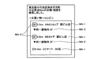
ここで、リスト出力部102dは、抽出施設リスト中の施設のうち基準地点と同一の建物IDである施設に対して、同一の建物内に存在することを示す同一建物表示データ(文字情報やアイコン等)を出力部114を介して出力させてもよく、フロアIDに基づくフロア表示データ(文字情報やアイコン等)を出力部114を介して出力させてもよい。例えば、図5に示すように、リスト出力部102dの制御による抽出施設リストの表示画面には、施設までの距離および施設名の表示領域MA−1のほかに、同一建物表示データおよびフロア表示データの文字表示領域MA−2が含まれてもよい。図5に示すように、抽出施設リストは同一建物内であることを考慮した評価値に基づきソートされているので、同一建物内の施設が上位に表示される。また、更に、図6に示すように、この抽出施設リストの表示画面には、施設までの距離および施設名の表示領域MA−1と、同一建物表示データおよびフロア表示データの文字表示領域MA−2に加えて、同一建物表示データおよびフロア表示データのアイコン表示領域MA−3が含まれてもよい。
Here, the
なお、現在位置が駅ビル等の建物内である場合には、図7に示すように、同一建物表示データは出力することなく、抽出施設リストの表示画面には、施設までの距離と施設名の表示領域MA−1に加えて、建物表示データのアイコン表示領域MA−4と、建物表示データおよびフロア表示データの文字表示領域MA−5とが含まれてもよい。このように、現在位置等の基準地点が建物外である場合には、建物内の施設であることを示すアイコンや文字を表示することにより、利用者が建物内の施設よりも建物に入らないで済む施設を選択しやすいように抽出施設リストを提示することができる。 If the current position is in a building such as a station building, as shown in FIG. 7, the same building display data is not output and the extracted facility list display screen displays the distance to the facility and the facility name. In addition to the display area MA-1, an icon display area MA-4 for building display data and a character display area MA-5 for building display data and floor display data may be included. In this way, when the reference point such as the current position is outside the building, by displaying an icon or character indicating that the facility is in the building, the user does not enter the building more than in the building. The extracted facility list can be presented so that it is easy to select a facility that can be completed.
また、リスト出力部102dは、抽出施設リスト中の施設のうち基準地点と同一の建物IDである施設に対して、基準地点から当該施設までの移動手段を示す移動手段表示データ(文字情報やアイコン等)を出力部114を介して出力させてもよい。例えば、図8に示すように、リスト出力部102dにより出力される抽出施設リストの表示画面には、施設までの距離と施設名の表示領域MA−1に加えて、同一建物表示データやフロア表示データや移動手段表示データの文字表示領域MA−6が含まれてもよい。このように、エレベータやエスカレータ等の移動手段を示す文字やアイコン等を表示することにより、利用者が移動しやすい移動手段で到達できる施設を選択しやすいように抽出施設リストを提示することができる。
Further, the
[第2の実施形態]
続いて、本発明の第2の実施形態(ナビゲーションサーバ200(サーバ主導型))について、図9および図10を参照して以下に説明する。ここで、図9は、第2の実施形態におけるナビゲーションサーバ200の構成の一例を示すブロック図であり、該構成のうち本発明に関係する部分のみを概念的に示している。また、図10は、第2の実施形態におけるナビゲーションサーバ200の処理の一例を示すフローチャートである。
[Second Embodiment]
Next, a second embodiment (navigation server 200 (server-driven type)) of the present invention will be described below with reference to FIGS. 9 and 10. Here, FIG. 9 is a block diagram showing an example of the configuration of the
なお、第2の実施形態においては、ナビゲーションサーバ200にて、基準地点情報を取得し、ナビゲーション装置100の出力部114に表示させるデータを生成し、このデータをナビゲーション装置100へ送信することにより、当該ナビゲーション装置100の出力部114を機能させている。このように、第2の実施形態は、ナビゲーションサーバ200にてサーバ主導で処理を行う点がその他の実施形態と異なる。
In the second embodiment, the
[ナビゲーションサーバ200(サーバ主導型)の構成]
まず、第2の実施形態におけるナビゲーションサーバ200(サーバ主導型)の構成の一例について、図9を参照して以下に説明する。
[Configuration of the navigation server 200 (server-driven type)]
First, an example of the configuration of the navigation server 200 (server-driven type) in the second embodiment will be described below with reference to FIG.
図9に示すように、本発明の第2の実施形態のナビゲーションサーバ200は、位置取得部112と出力部114と入力部116とを少なくとも備えたナビゲーション装置100に通信可能に接続された、制御部202と記憶部206とを少なくとも備えて構成される。通信には、一例として、ネットワーク300を介した有線・無線通信等の遠隔通信等を含む。また、これらナビゲーションサーバ200およびナビゲーション装置100の各部は任意の通信路を介して通信可能に接続されている。
As illustrated in FIG. 9, the
図9において、ナビゲーションサーバ200は、基準地点情報を取得し、取得した基準地点情報に含まれる基準地点の座標と、記憶部206に記憶された施設の座標と、を比較することにより、基準地点から所定の範囲内に存在する施設を抽出し、抽出した施設の座標、建物ID、および、フロアIDと、取得した基準地点情報に含まれる基準地点の座標、建物ID、および、フロアIDと、を比較することにより、当該抽出された施設を評価し、評価値を生成し、生成した評価値に基づいて、抽出した施設をソートした抽出施設リストを表示した表示画面データを生成し、生成した抽出施設リストの表示画面データをナビゲーション装置100に送信することにより、抽出施設リストの表示画面データを出力部114を介して出力させる制御を行う等の機能を有する。
In FIG. 9, the
なお、ナビゲーションサーバ200における通信制御インターフェース部204および記憶部206(施設情報データベース206a、ネットワークデータベース206b等)の機能、また、ナビゲーション装置100における位置取得部112、出力部114、および、入力部116の機能は、第1の実施形態と同様であるため説明を省略する。
Note that the functions of the communication
また、図9において、制御部202は、OS等の制御プログラムや、各種の処理手順等を規定したプログラム、および、所要データを格納するための内部メモリを有する。そして、制御部202は、これらのプログラム等により、種々の処理を実行するための情報処理を行う。制御部202は、機能概念的に、周辺施設抽出部202b、施設評価値生成部202c、抽出施設リスト生成部202e、位置情報信号受信部202g、基準地点情報取得部202h、および、リスト出力制御部202jを備えて構成される。なお、周辺施設抽出部202b、施設評価値生成部202c、移動コスト生成部202dの機能は、第1の実施形態と同様であるため説明を省略する。
In FIG. 9, the
このうち、抽出施設リスト生成部202eは、施設評価値生成部202cにより生成された評価値に基づいて、周辺施設抽出部202bにより抽出された施設をソートした抽出施設リストを表示した表示画面データを生成する抽出施設リスト生成手段である。すなわち、抽出施設リスト生成部202eが生成した抽出施設リストの表示画面データを生成する点のみが第1の実施の形態と異なる。
Among them, the extracted facility
また、位置情報信号受信部202gは、ナビゲーション装置100から送信される、位置取得部112により取得された位置情報信号を受信する位置情報信号受信手段である。
The position information
また、基準地点情報取得部202hは、基準地点の座標や、当該基準地点が存在する建物の建物IDや、当該基準地点が存在する当該建物のフロアのフロアID等を含む基準地点情報を取得する基準地点情報取得手段である。ここで、基準地点情報取得部202hは、位置情報信号受信部202gにより受信された位置情報信号に基づいて、ナビゲーション装置100の利用者の現在位置を算出することにより基準地点情報を取得してもよい。例えば、基準地点情報取得部202hにより取得される基準地点情報は、建物(例えば、ビルや立体駐車場等)内の各フロアや地下構造物(例えば、トンネル、地下駐車場等)の各所に設置されたIMES装置等の位置発信装置500から発信された設置場所に応じた自己位置情報(建物IDやフロアIDなどの位置ID)であってもよく、位置情報信号に基づいて算出された座標であってもよい。なお、基準地点情報取得部202hは、建物IDやフロアIDを取得できない場合は、建物IDやフロアIDを空欄として基準地点の座標を格納した基準地点情報を取得してもよい。また、基準地点情報取得部202hは、利用者に入力部116を介して入力させた施設カテゴリ情報(利用者の所望の施設種別の情報等)や所定範囲情報(利用者の所望の検索範囲等)をナビゲーション装置100から受信して基準地点情報に対応付けて格納してもよい。
Further, the reference point
また、リスト出力制御部202jは、抽出施設リスト生成部202eにより生成された抽出施設リストの表示画面データをナビゲーション装置100に送信することにより、抽出施設リストの表示画面データを出力部114を介して出力させる制御を行うリスト出力制御手段である。
Further, the list
以上で、第2の実施形態におけるナビゲーションサーバ200の構成の一例の説明を終える。
Above, description of an example of a structure of the
[ナビゲーションサーバ200(サーバ主導型)の処理]
次に、このように構成された第2の実施形態におけるナビゲーションサーバ200の処理の一例について、以下に図10を参照して詳細に説明する。
[Processing of navigation server 200 (server-driven type)]
Next, an example of processing of the
図10に示すように、まず、ナビゲーション装置100から位置取得部112により取得された位置情報信号が送信されると(ステップSD−1)、ナビゲーションサーバ200の位置情報信号受信部202gは、位置情報信号を受信する(ステップSD−2)。
As shown in FIG. 10, first, when the position information signal acquired by the
そして、ナビゲーションサーバ200の基準地点情報取得部202hは、位置情報信号受信部202gにより受信された位置情報信号に基づいて、基準地点の座標や、当該基準地点が存在する建物の建物IDや、当該基準地点が存在する当該建物のフロアのフロアID等を含む基準地点情報を取得する(ステップSD−3)。例えば、基準地点情報取得部202hは、位置情報信号に基づいて座標を算出して、基準地点情報として取得してもよい。また、基準地点情報取得部202hは、IMES技術等を用いて位置取得部112により取得された自己位置情報(建物IDやフロアIDなどの位置ID)を、基準地点情報の建物IDやフロアIDとしてもよい。なお、基準地点情報取得部202hは、建物IDやフロアIDを取得できない場合は、記憶部206等に記憶された地図データを参照して基準地点の座標から対応する建物IDやフロアID等を取得してもよく、基準地点に対応する建物IDがない場合は基準地点情報の建物IDを空欄としてもよい。
Then, the reference point
そして、ナビゲーションサーバ200の周辺施設抽出部202bは、基準地点情報取得部202hにより取得された基準地点情報に含まれる基準地点の座標と、施設情報データベース206aに記憶された施設の座標と、を比較することにより、基準地点から所定の範囲内に存在する施設を抽出する(ステップSD−4)。すなわち、周辺施設抽出部202bは、基準地点情報の基準地点の座標から所定の範囲内(例えば、5km以内など)に存在する施設情報を、施設情報データベース206aから検索して抽出する。
Then, the peripheral
そして、ナビゲーションサーバ200の施設評価値生成部202cは、周辺施設抽出部202bにより抽出された施設の座標、建物ID、および、フロアIDと、基準地点情報受信部202aにより受信された基準地点情報に含まれる基準地点の座標、建物ID、および、フロアIDと、を比較することにより、当該抽出された施設を評価し、評価値を生成する(ステップSD−5)。例えば、施設評価値生成部202cは、基準地点からの距離(例えば、基準地点の座標から施設の座標までの距離)や、基準地点と同一の建物IDか否か、基準地点と同一のフロアIDか否か等に基づいて、基準地点や各施設が屋内か屋外かを考慮した評価値を生成してもよい。また、施設評価値生成部202cは、移動コスト生成部202dにより生成された移動コストについて、基準地点が建物内の場合には基準地点と同一の建物IDの施設の移動コストを下げるように制御し、一方、基準地点が建物外である場合には建物内の施設の移動コストを上げるように制御し、当該移動コストに基づいて、評価値を生成してもよい。なお、この施設評価値生成部202cにより生成される評価値は、周辺施設抽出部202bにより抽出された複数の施設に対して優先順位を付ける等の目的で使用される。一例として、施設評価値生成部202cは、同一建物IDで同一フロアIDの施設、同一建物IDで異なるフロアIDの施設、距離が近い屋外の施設の順に、優先順位が付けられるよう各評価値を生成してもよい。
The facility evaluation
そして、ナビゲーションサーバ200の抽出施設リスト生成部202eは、施設評価値生成部202cにより生成された評価値に基づいて、周辺施設抽出部202bにより抽出された施設をソートした抽出施設リストを表示するための表示画面データを生成する(ステップSD−6)。例えば、抽出施設リスト生成部202eは、施設評価値生成部202cにより生成された評価値に基づいて、優先順位が高い順に(例えば、優先順位が高いほど評価値が高い場合は評価値の降順に)、施設情報(施設名など)を並べ替えて施設情報を格納した抽出施設リストの表示画面データを生成する。ここで、抽出施設リスト生成部202eは、抽出施設リストの施設のうち基準地点と同一の建物IDである施設に対して同一の建物内に存在することを示す同一建物表示データを抽出施設リストの表示画面データに含めてもよい。また、抽出施設リスト生成部202eは、抽出施設リスト中の施設のうち基準地点と同一の建物IDである施設に対してフロアIDに基づくフロア表示データを抽出施設リストの表示画面データに含めてもよい。また、抽出施設リスト生成部202eは、抽出施設リスト中の施設のうち基準地点と同一の建物IDである施設に対して、基準地点から当該施設までの移動手段を示す移動手段表示データを抽出施設リストの表示画面データに含めてもよい。
Then, the extracted facility
そして、ナビゲーションサーバ200のリスト出力制御部202jは、抽出施設リスト生成部202eにより生成された抽出施設リストの表示画面データをナビゲーション装置100に送信することにより(ステップSD−7)、抽出施設リストの表示画面データがナビゲーション装置100の出力部114を介して表示出力されるよう制御する(ステップSD−8)。
Then, the list
以上で、第2の実施形態におけるナビゲーションサーバ200の処理の一例の説明を終える。
Above, description of an example of the process of the
[第3の実施形態]
続いて、本発明の第3の実施形態(ナビゲーション装置100(スタンドアローン型))について、図11および図12を参照して以下に説明する。ここで、図11は、第3の実施形態におけるナビゲーション装置100の構成の一例を示すブロック図であり、該構成のうち本発明に関係する部分のみを概念的に示している。また、図12は、第3の実施形態におけるナビゲーション装置100の処理の一例を示すフローチャートである。
[Third Embodiment]
Next, a third embodiment (navigation device 100 (stand-alone type)) of the present invention will be described below with reference to FIGS. 11 and 12. Here, FIG. 11 is a block diagram showing an example of the configuration of the
なお、第3の実施形態においては、全ての機能をナビゲーション装置100に集約し、ナビゲーションサーバ200に接続することなく、基準地点の座標や、当該基準地点が存在する建物の建物IDや、当該基準地点が存在する当該建物のフロアのフロアID等を含む基準地点情報を取得し、取得された基準地点情報に含まれる基準地点の座標と、施設情報記憶手段に記憶された施設の座標と、を比較することにより、基準地点から所定の範囲内に存在する施設を抽出し、抽出された施設の座標、建物ID、および、フロアIDと、取得された基準地点情報に含まれる基準地点の座標、建物ID、および、フロアIDと、を比較することにより、当該抽出された施設を評価し、評価値を生成し、生成された評価値に基づいて、抽出された施設をソートした抽出施設リストを生成し、生成された抽出施設リストを出力部を介して出力させている。このように、第3の実施形態は、ナビゲーション装置100がスタンドアローン型に構成され単独で処理を行う点がその他の実施形態と異なる。
In the third embodiment, all functions are integrated into the
[ナビゲーション装置100(スタンドアローン型)の構成]
まず、第3の実施形態におけるナビゲーション装置100(スタンドアローン型)の構成の一例について、図11を参照して以下に説明する。
[Configuration of navigation device 100 (stand-alone type)]
First, an example of the configuration of the navigation device 100 (stand-alone type) in the third embodiment will be described below with reference to FIG.
図11に示すように、本発明の第3の実施形態のナビゲーション装置100は、位置発信装置500から発信される位置情報信号を受信する位置取得部112と出力部114と入力部116と制御部102と記憶部106とを少なくとも備えて構成される。これらナビゲーション装置100の各部は任意の通信路を介して通信可能に接続されている。
As shown in FIG. 11, the
図11において、入出力制御インターフェース部108、位置取得部112、出力部114、および、入力部116の各機能は、第1の実施形態と同様であるため説明を省略する。また、記憶部106の各部(施設情報データベース106bおよびネットワークデータベース106c等)についても、ナビゲーションサーバ200ではなくナビゲーション装置100に備えられている点を除き、各機能が第1の実施形態と同様であるため説明を省略する。
In FIG. 11, the functions of the input / output
また、制御部102の各部については、本実施形態のナビゲーション装置100がスタンドアローン型であり、制御部102が各送受信部を備えていない点を除き、各機能は第1の実施形態と基本的に同様である。
As for each part of the
また、図11において、制御部102は、OS等の制御プログラムや、各種の処理手順等を規定したプログラム、および、所要データを格納するための内部メモリを有する。そして、制御部102は、これらのプログラム等により、種々の処理を実行するための情報処理を行う。制御部102は、機能概念的に、基準地点情報取得部102a、リスト出力部102d、周辺施設抽出部102e、施設評価値生成部102f、移動コスト生成部102g、および、抽出施設リスト生成部102hを備えて構成される。
In FIG. 11, the
このうち、基準地点情報取得部102aは、ナビゲーション装置100の利用者の現在位置等の基準地点の座標や、建物IDや、フロアID等の基準地点情報を取得する基準地点情報取得手段である。ここで、基準地点情報取得部102aは、位置取得部112にて位置発信装置500から受信した位置情報信号から算出した位置情報や、位置取得部112の方位センサにて検出したナビゲーション装置100の進行方向等の方位情報を考慮した位置情報等を、基準地点情報として取得してもよい。例えば、基準地点情報取得部102aは、建物(例えば、ビルや立体駐車場等)内の各フロアや地下構造物(例えば、トンネル、地下駐車場等)の各所に設置されたIMES装置等の位置発信装置500から発信される、設置場所に応じた自己位置情報(建物IDやフロアIDなどの位置ID)を位置取得部112にて受信することにより、基準地点情報を取得してもよい。このほか、基準地点情報取得部102aは、位置取得部112により取得される位置情報信号を任意の手段で解析することにより、座標や建物IDやフロアIDを取得してもよい。なお、基準地点情報取得部102aは、建物IDやフロアIDを取得できない場合は、少なくとも基準地点の座標を含む基準地点情報を取得してもよい。また、基準地点情報取得部102aは、利用者により入力部116を介して入力された位置座標や建物IDやフロアID等を基準地点情報として取得してもよい。具体的には、基準地点情報取得部102aは、入力部116を介して利用者に表示部に表示された地図データの表示画面上で指定(例えば、タッチパネル式の表示部での指定操作等)させた座標や対応する建物IDやフロアID等を基準地点情報として取得してもよい。また、基準地点情報取得部102aは、予め記憶部106に記憶された基準地点情報を取得してもよい。なお、基準地点情報取得部102aは、利用者に入力部116を介して入力させた施設カテゴリ情報(利用者の所望の施設種別の情報等)を基準地点情報に対応付けて格納してもよい。
Among these, the reference point
また、リスト出力部102dは、後述する抽出施設リスト生成部102hにより生成された抽出施設リストを出力部114を介して出力させるリスト出力手段である。ここで、リスト出力部102dは、抽出施設リスト中の施設のうち基準地点と同一の建物IDである施設に対して同一の建物内に存在することを示す同一建物表示データを出力部114を介して出力させてもよい。また、リスト出力部102dは、抽出施設リスト中の施設のうち基準地点と同一の建物IDである施設に対してフロアIDに基づくフロア表示データを出力部114を介して出力させてもよい。また、リスト出力部102dは、抽出施設リスト中の施設のうち基準地点と同一の建物IDである施設に対して、基準地点から当該施設までの移動手段を示す移動手段表示データを出力部114を介して出力させてもよい。ここで、リスト出力部102dは、出力部114に出力された抽出施設リスト中の施設を利用者により入力部116を介して選択させるよう制御し、選択された施設に対応付けて格納された案内経路や地図データや案内データ等を出力部114を介して出力させることにより、経路案内を実行してもよい。例えば、リスト出力部102dは、位置取得部112にて位置発信装置500から受信した位置情報信号から算出した位置情報の更新等によるナビゲーション装置100の利用者の現在位置情報を案内経路や地図データに重畳して表示した表示画面を出力部114に表示させることにより、経路案内を実行してもよい。その際、リスト出力部102dは、抽出施設リストの施設情報に対応付けて格納された案内データを出力部114を介して出力させてもよい。具体的には、リスト出力部102dは、案内経路上の分岐点等の案内地点における進行方向に対応付けられた音声案内データを、出力部114を介して音声出力させることにより、経路案内を実行してもよく、案内データに含まれるTBT等の表示案内データを表示した表示画面を出力部114に表示させることにより、経路案内を実行してもよい。
The
また、周辺施設抽出部102eは、基準地点情報取得部102aにより取得された基準地点情報に含まれる基準地点の座標と、施設情報データベース106bに記憶された施設の座標と、を比較することにより、基準地点から所定の範囲内に存在する施設を抽出する周辺施設抽出手段である。すなわち、周辺施設抽出部102eは、基準地点情報の基準地点の座標から所定の範囲内(例えば、5km以内など)に存在する施設情報を、施設情報データベース106bから検索して抽出する。なお、周辺施設抽出部102eは、基準地点情報取得部102aにより取得された基準地点情報に施設カテゴリ情報が含まれている場合は、当該施設カテゴリ情報により指定される施設カテゴリ(例えば、コンビニやガソリンスタンド等)の施設を抽出してもよい。
In addition, the peripheral
また、施設評価値生成部102fは、周辺施設抽出部102eにより抽出された施設の座標、建物ID、および、フロアIDと、基準地点情報取得部102aにより取得された基準地点情報に含まれる基準地点の座標、建物ID、および、フロアIDと、を比較することにより、当該抽出された施設を評価し、評価値を生成する施設評価値生成手段である。例えば、施設評価値生成部102fは、基準地点からの距離(例えば、基準地点の座標から施設の座標までの距離)や、基準地点と同一の建物IDか否か、基準地点と同一のフロアIDか否か、に基づいて評価値を生成してもよい。なお、この施設評価値生成部102fにより生成される評価値は、周辺施設抽出部102eにより抽出された複数の施設に対して優先順位を付ける等の目的で使用される。一例として、施設評価値生成部102fは、同一建物IDで同一フロアIDの施設、同一建物IDで異なるフロアIDの施設、距離が近い屋外の施設の順に、優先順位が付けられるよう各評価値を生成する。
In addition, the facility evaluation
ここで、図11に示すように、施設評価値生成部102fは、更に、移動コスト生成部102gを備え、基準地点が建物内の場合には基準地点と同一の建物IDの施設の移動コストを下げるように制御し、一方、基準地点が建物外である場合には建物内の施設の移動コストを上げるように制御し、当該移動コストに基づいて、評価値を生成してもよい。移動コスト生成部102gは、基準地点から施設までの経路探索を行い、当該経路探索結果に基づいて移動コストを生成する移動コスト生成手段である。一例として、移動コストは、距離や時間や料金等に関するコストであってもよい。ここで、移動コスト生成部102gは、ネットワークデータベース106cに記憶されたネットワークデータを用いて、基準地点の座標から施設の座標までの経路探索を行い、経路探索結果に基づいて移動コストを生成してもよい。より具体的には、移動コスト生成部102gは、周辺施設抽出部102eにより抽出された施設が基準地点と同一建物内にある場合は、ネットワークデータベース106cに記憶された建物内ネットワークデータを用いて、基準地点から施設までの経路を探索し、経路探索結果に基づいて移動コスト(水平方向の水平移動コストや垂直方向の垂直移動コスト等)を生成する。なお、移動コスト生成部102gは、基準地点から施設までの経路探索結果に基づいて、当該経路上の移動手段(エスカレータ、エレベータ、階段等)を考慮して移動コストを算出してもよい。一方、移動コスト生成部102gは、周辺施設抽出部102eにより抽出された施設が基準地点と同一建物内にない場合は、ネットワークデータベース106cに記憶された道路ネットワークデータと必要な建物内ネットワークデータを用いて、基準地点から施設までの経路を探索し、経路探索結果に基づいて移動コスト(水平方向の水平移動コストや垂直方向の垂直移動コスト等)を生成する。そして、施設評価値生成部102fは、移動コスト生成部102gにより算出された各移動コストについて、基準地点が建物内の場合には基準地点と同一の建物IDの施設の移動コストを下げるように制御し、一方、基準地点が建物外である場合には建物内の施設の移動コストを上げるように制御し、当該移動コストに基づいて評価値を生成する。これにより、緯度経度等の座標に基づいて単純に算出される基準地点から施設までの距離だけではなく、建物内にあるか否かを考慮して生成された移動コストに基づいて、建物内にある施設の優先順位を高めて評価値を生成することができる。なお、施設評価値生成部102fは、ネットワーク300等を介して天候情報等を取得することにより天候情報等を考慮して移動コストの重み付けを行ってもよい。例えば、施設評価値生成部102fは、天候情報により天候が雨の場合は、屋外の経路に比べて建物内の経路の移動コストを低く見積もってもよい。
Here, as shown in FIG. 11, the facility evaluation
また、抽出施設リスト生成部102hは、施設評価値生成部102fにより生成された評価値に基づいて、周辺施設抽出部102eにより抽出された施設をソートした抽出施設リストを生成する抽出施設リスト生成手段である。例えば、抽出施設リスト生成部102hは、施設評価値生成部102fにより生成された評価値に基づいて、優先順位が高い順に(例えば、優先順位が高いほど評価値が高い場合は降順に)、施設情報(施設名など)を並べ替えて施設情報を格納した抽出施設リストを作成する。なお、抽出施設リストには、各施設情報に対応付けて、施設評価値生成部102fにより算出された基準地点から施設までの距離や経路や移動手段等や、記憶部106に記憶された施設の地図データや案内データ等を格納してもよい。
The extracted facility
以上で、第3の実施形態におけるナビゲーション装置100の構成の一例の説明を終える。
Above, description of an example of a structure of the
[ナビゲーション装置100(スタンドアローン型)の処理]
次に、このように構成された第3の実施形態におけるナビゲーション装置100の処理の一例について、以下に図12を参照して詳細に説明する。
[Processing of navigation device 100 (stand-alone type)]
Next, an example of processing of the
図12に示すように、まず、基準地点情報取得部102aは、ナビゲーション装置100の利用者の現在位置等の基準地点の座標や、建物IDや、フロアID等の基準地点情報を取得する(ステップSE−1)。ここで、基準地点情報取得部102aは、位置取得部112にて位置発信装置500から受信した位置情報信号から算出した位置情報等の座標を、基準地点情報として取得してもよい。また、基準地点情報取得部102aは、建物(例えば、ビルや立体駐車場等)内の各フロアや地下構造物(例えば、トンネル、地下駐車場等)の各所に設置されたIMES装置等の位置発信装置500から発信される、設置場所に応じた自己位置情報(建物IDやフロアIDなどの位置ID)を位置取得部112にて受信することにより、基準地点情報を取得してもよい。なお、基準地点情報取得部102aは、建物IDやフロアIDを取得できない場合は、建物IDやフロアIDを空欄として基準地点の座標を格納した基準地点情報を取得してもよい。また、基準地点情報取得部102aは、利用者に入力部116を介して入力させた施設カテゴリ情報(利用者の所望の施設種別の情報等)や所定範囲情報(利用者の所望の検索範囲等)を基準地点情報に対応付けて格納してもよい。
As shown in FIG. 12, the reference point
そして、周辺施設抽出部102eは、基準地点情報取得部102aにより取得された基準地点情報に含まれる基準地点の座標と、施設情報データベース106bに記憶された施設の座標と、を比較することにより、基準地点から所定の範囲内に存在する施設を抽出する(ステップSE−2)。ここで、所定の範囲は、一定の値であってもよく、基準地点情報で指定された検索範囲であってもよい。すなわち、周辺施設抽出部102eは、基準地点情報の基準地点の座標から所定の範囲内(例えば、5km以内など)に存在する施設情報を、施設情報データベース106bから検索して抽出する。なお、周辺施設抽出部102eは、基準地点情報取得部102aにより取得された基準地点情報に施設カテゴリ情報が含まれている場合は、当該施設カテゴリ情報により指定される施設カテゴリ(例えば、コンビニやガソリンスタンド等)の施設のみを抽出してもよい。
Then, the surrounding
そして、施設評価値生成部102fは、周辺施設抽出部102eにより抽出された施設の座標、建物ID、および、フロアIDと、基準地点情報取得部102aにより取得された基準地点情報に含まれる基準地点の座標、建物ID、および、フロアIDと、を比較することにより、当該抽出された施設を評価し、評価値を生成する(ステップSE−3)。例えば、施設評価値生成部102fは、基準地点からの距離(例えば、基準地点の座標から施設の座標までの距離)や、基準地点と同一の建物IDか否か、基準地点と同一のフロアIDか否か、に基づいて評価値を生成してもよい。なお、この施設評価値生成部102fにより生成される評価値は、周辺施設抽出部102eにより抽出された複数の施設に対して優先順位を付ける等の目的で使用される。一例として、施設評価値生成部102fは、同一建物IDで同一フロアIDの施設、同一建物IDで異なるフロアIDの施設、距離が近い屋外の施設の順に、優先順位が付けられるよう各評価値を生成する。
Then, the facility evaluation
そして、抽出施設リスト生成部102hは、施設評価値生成部102fにより生成された評価値に基づいて、周辺施設抽出部102eにより抽出された施設をソートした抽出施設リストを生成する(ステップSE−4)。例えば、抽出施設リスト生成部102hは、施設評価値生成部102fにより生成された評価値に基づいて、優先順位が高い順に(例えば、優先順位が高いほど評価値が高い場合は降順に)、施設情報(施設名など)を並べ替えて施設情報を格納した抽出施設リストを作成する。なお、抽出施設リストには、各施設情報に対応付けて、施設評価値生成部102fにより算出された基準地点から施設までの距離や経路や移動手段等や、記憶部106に記憶された施設の地図データや案内データ等を格納してもよい。
Then, the extracted facility
また、リスト出力部102dは、抽出施設リスト生成部102hにより生成された抽出施設リストを出力部114を介して出力させる(ステップSE−5)。ここで、リスト出力部102dは、抽出施設リスト中の施設のうち基準地点と同一の建物IDである施設に対して同一の建物内に存在することを示す同一建物表示データを出力部114を介して出力させてもよい。また、リスト出力部102dは、抽出施設リスト中の施設のうち基準地点と同一の建物IDである施設に対してフロアIDに基づくフロア表示データを出力部114を介して出力させてもよい。また、リスト出力部102dは、抽出施設リスト中の施設のうち基準地点と同一の建物IDである施設に対して、基準地点から当該施設までの移動手段を示す移動手段表示データを出力部114を介して出力させてもよい。ここで、リスト出力部102dは、出力部114に出力された抽出施設リスト中の施設を利用者により入力部116を介して選択させるよう制御し、選択された施設に対応付けて格納された案内経路や地図データや案内データ等を出力部114を介して出力させることにより、経路案内を実行してもよい。例えば、リスト出力部102dは、位置取得部112にて位置発信装置500から受信した位置情報信号から算出した位置情報の更新等によるナビゲーション装置100の利用者の現在位置情報を案内経路や地図データに重畳して表示した表示画面を出力部114に表示させることにより、経路案内を実行してもよい。その際、リスト出力部102dは、抽出施設リストの施設情報に対応付けて格納された案内データを出力部114を介して出力させてもよい。具体的には、リスト出力部102dは、案内経路上の分岐点等の案内地点における進行方向に対応付けられた音声案内データを、音声出力部を介して出力させることにより、経路案内を実行してもよく、案内データに含まれるTBT等の表示案内データを表示した表示画面を表示部に表示させることにより、経路案内を実行してもよい。
The
以上で、第3の実施形態におけるナビゲーション装置100の処理の一例の説明を終える。
Above, description of an example of the process of the
[他の実施の形態]
さて、これまで本発明の実施形態について説明したが、本発明は、上述した実施の形態以外にも、上記特許請求の範囲に記載した技術的思想の範囲内において種々の異なる実施の形態にて実施されてよいものである。
[Other embodiments]
Although the embodiments of the present invention have been described so far, the present invention is not limited to the above-described embodiments, but can be applied to various different embodiments within the scope of the technical idea described in the claims. It may be implemented.
また、実施の形態において説明した各処理のうち、自動的に行われるものとして説明した処理の全部または一部を手動的に行うこともでき、あるいは、手動的に行われるものとして説明した処理の全部または一部を公知の方法で自動的に行うこともできる。 In addition, among the processes described in the embodiment, all or part of the processes described as being automatically performed can be performed manually, or the processes described as being performed manually can be performed. All or a part can be automatically performed by a known method.
このほか、上記文献中や図面中で示した処理手順、制御手順、具体的名称、各処理の登録データや検索条件等のパラメータを含む情報、画面例、データベース構成については、特記する場合を除いて任意に変更することができる。 In addition, unless otherwise specified, the processing procedures, control procedures, specific names, information including registration data for each processing, parameters such as search conditions, screen examples, and database configurations shown in the above documents and drawings Can be changed arbitrarily.
また、ナビゲーション装置100、および、ナビゲーションサーバ200に関して、図示の各構成要素は機能概念的なものであり、必ずしも物理的に図示の如く構成されていることを要しない。
Further, regarding the
例えば、ナビゲーション装置100、および、ナビゲーションサーバ200の各装置が備える処理機能、特に制御部102および制御部202にて行われる各処理機能については、その全部または任意の一部を、CPU(Central Processing Unit)および当該CPUにて解釈実行されるプログラムにて実現することができ、あるいは、ワイヤードロジックによるハードウェアとして実現することも可能である。尚、プログラムは、後述する記録媒体に記録されており、必要に応じてナビゲーション装置100、および、ナビゲーションサーバ200に機械的に読み取られる。すなわち、ROMまたはHD等の記憶部106および記憶部206等は、OSとして協働してCPUに命令を与え、各種処理を行うためのコンピュータプログラムが記録されている。このコンピュータプログラムは、RAMにロードされることによって実行され、CPUと協働して制御部を構成する。
For example, the processing functions provided in each device of the
また、このコンピュータプログラムは、ナビゲーション装置100、および、ナビゲーションサーバ200に対して任意のネットワーク300を介して接続されたアプリケーションプログラムサーバに記憶されていてもよく、必要に応じてその全部または一部をダウンロードすることも可能である。
The computer program may be stored in the
また、本発明に係るプログラムを、コンピュータ読み取り可能な記録媒体に格納することもできる。ここで、この「記録媒体」とは、フレキシブルディスク、光磁気ディスク、ROM、EPROM、EEPROM、CD−ROM、MO、DVD、Blu−ray Disc等の任意の「可搬用の物理媒体」、あるいは、LAN、WAN、インターネットに代表されるネットワークを介してプログラムを送信する場合の通信回線や搬送波のように、短期にプログラムを保持する「通信媒体」を含むものとする。 The program according to the present invention can also be stored in a computer-readable recording medium. Here, the “recording medium” is an arbitrary “portable physical medium” such as a flexible disk, a magneto-optical disk, a ROM, an EPROM, an EEPROM, a CD-ROM, an MO, a DVD, a Blu-ray Disc, or the like. It includes a “communication medium” that holds a program in a short period of time, such as a communication line or a carrier wave when a program is transmitted via a network represented by a LAN, WAN, or the Internet.
また、「プログラム」とは、任意の言語や記述方法にて記述されたデータ処理方法であり、ソースコードやバイナリコード等の形式を問わない。なお、「プログラム」は必ずしも単一的に構成されるものに限られず、複数のモジュールやライブラリとして分散構成されるものや、OSに代表される別個のプログラムと協働してその機能を達成するものをも含む。なお、実施の形態に示した各装置において記録媒体を読み取るための具体的な構成、読み取り手順、あるいは、読み取り後のインストール手順等については、周知の構成や手順を用いることができる。 The “program” is a data processing method described in an arbitrary language or description method, and may be in any format such as source code or binary code. Note that the “program” is not necessarily limited to a single configuration, and functions are achieved in cooperation with a separate configuration such as a plurality of modules and libraries or a separate program represented by the OS. Including things. Note that a well-known configuration and procedure can be used for a specific configuration for reading a recording medium, a reading procedure, an installation procedure after reading, and the like in each device described in the embodiment.
記憶部106および記憶部206に格納される各種のデータベース等(抽出リストファイル106a〜ネットワークデータベース106c、施設情報データベース206a、ネットワークデータベース206b等)は、RAM、ROM等のメモリ装置、ハードディスク等の固定ディスク装置、フレキシブルディスク、光ディスク等のストレージ手段であり、各種処理やウェブサイト提供に用いる各種のプログラムやテーブルやデータベースやウェブページ用ファイル等を格納する。
Various databases (
また、ナビゲーション装置100、および、ナビゲーションサーバ200は、既知のパーソナルコンピュータ、ワークステーション等の情報処理装置を接続し、該情報処理装置に本発明の方法を実現させるソフトウェア(プログラム、データ等を含む)を実装することにより実現してもよい。
Further, the
更に、装置の分散・統合の具体的形態は図示するものに限られず、その全部または一部を、各種の付加等に応じて、または、機能負荷に応じて、任意の単位で機能的または物理的に分散・統合して構成することができる。 Furthermore, the specific form of distribution / integration of the devices is not limited to that shown in the figure, and all or a part of them may be functional or physical in arbitrary units according to various additions or according to functional loads. Can be distributed and integrated.
以上詳述したように、本発明によれば、基準となる地点が建物内の場合、優先的に当該建物内の店舗を検索するなど、屋内屋外を考慮した周辺検索をすることができるナビゲーションシステム、ナビゲーション装置、ナビゲーションサーバ、および、周辺検索方法を提供することができるので、周辺検索を行う情報機器や情報処理分野などの様々な分野において極めて有用である。 As described above in detail, according to the present invention, when a reference point is in a building, a navigation system capable of searching surroundings in consideration of indoors and outdoors, such as preferentially searching for a store in the building. Since the navigation device, the navigation server, and the peripheral search method can be provided, the present invention is extremely useful in various fields such as an information device for performing the peripheral search and the information processing field.
100 ナビゲーション装置
102 制御部
102a 基準地点情報取得部
102b 基準地点情報送信部
102c 抽出施設リスト受信部
102d リスト出力部
102e 周辺施設抽出部
102f 施設評価値生成部
102g 移動コスト生成部
102h 抽出施設リスト生成部
104 通信制御インターフェース部
106 記憶部
106a 抽出リストファイル
106b 施設情報データベース
106c ネットワークデータベース
108 入出力制御インターフェース部
112 位置取得部
114 出力部
116 入力部
200 ナビゲーションサーバ
202 制御部
202a 基準地点情報受信部
202b 周辺施設抽出部
202c 施設評価値生成部
202d 移動コスト生成部
202e 抽出施設リスト生成部
202f 抽出施設リスト送信部
202g 位置情報信号受信部
202h 基準地点情報取得部
202j リスト出力制御部
204 通信制御インターフェース部
206 記憶部
206a 施設情報データベース
206b ネットワークデータベース
300 ネットワーク
500 位置発信装置
100
102a Reference point information acquisition unit
102b Reference point information transmitter
102c Extraction facility list receiver
102d List output part
102e peripheral facility extraction unit
102f Facility evaluation value generator
102g Moving cost generator
102h Extracted facility
106a Extraction list file
106b Facility information database
202a Reference point information receiver
202b Peripheral facility extraction unit
202c Facility evaluation value generator
202d Moving cost generator
202e Extracted facility list generator
202f Extracted facility list transmitter
202g Position information signal receiver
202h Reference point information acquisition unit
202j List
206a Facility information database
Claims (15)
上記記憶部は、
各施設について、当該施設の座標と、当該施設が存在する建物の建物IDと、当該施設が存在する当該建物のフロアのフロアIDと、を対応付けて記憶する施設情報記憶手段、
を備え、
上記ナビゲーションサーバの上記制御部は、
上記ナビゲーション装置から送信される、基準地点の座標と、当該基準地点が存在する上記建物の上記建物IDと、当該基準地点が存在する当該建物の上記フロアの上記フロアIDと、を含む基準地点情報を受信する基準地点情報受信手段と、
上記基準地点情報受信手段により受信された上記基準地点情報に含まれる上記基準地点の座標と、上記施設情報記憶手段に記憶された上記施設の上記座標と、を比較することにより、上記基準地点から所定の範囲内に存在する上記施設を抽出する周辺施設抽出手段と、
上記周辺施設抽出手段により抽出された上記施設の上記座標、上記建物ID、および、上記フロアIDと、上記基準地点情報受信手段により受信された上記基準地点情報に含まれる上記基準地点の座標、上記建物ID、および、上記フロアIDと、を比較することにより、当該抽出された上記施設を評価し、評価値を生成する施設評価値生成手段と、
上記施設評価値生成手段により生成された上記評価値に基づいて、上記周辺施設抽出手段により抽出された上記施設をソートした抽出施設リストを生成する抽出施設リスト生成手段と、
上記抽出施設リスト生成手段により生成された上記抽出施設リストを上記ナビゲーション装置に送信する抽出施設リスト送信手段と、
を備え、
上記ナビゲーション装置の上記制御部は、
上記基準地点情報を上記ナビゲーションサーバに送信する基準地点情報送信手段と、
上記ナビゲーションサーバから送信される上記抽出施設リストを受信する抽出施設リスト受信手段と、
上記抽出施設リスト受信手段により受信された上記抽出施設リストを上記出力部を介して出力させるリスト出力手段と、
を備えたことを特徴とする、ナビゲーションシステム。 A navigation system in which a navigation server including at least a control unit and a storage unit, and a navigation device including at least a control unit and an output unit are communicably connected,
The storage unit
Facility information storage means for storing the coordinates of the facility, the building ID of the building where the facility exists, and the floor ID of the floor of the building where the facility exists in association with each facility;
With
The control unit of the navigation server is
Reference point information including coordinates of a reference point, the building ID of the building where the reference point exists, and the floor ID of the floor of the building where the reference point exists, transmitted from the navigation device A reference point information receiving means for receiving
By comparing the coordinates of the reference point included in the reference point information received by the reference point information receiving means with the coordinates of the facility stored in the facility information storage means, A surrounding facility extraction means for extracting the facility existing within a predetermined range;
The coordinates of the reference point included in the reference point information received by the reference point information receiving means, the coordinates of the facility, the building ID, and the floor ID extracted by the peripheral facility extraction means, A facility evaluation value generating means for evaluating the extracted facility by comparing the building ID and the floor ID, and generating an evaluation value;
Based on the evaluation value generated by the facility evaluation value generation means, an extracted facility list generation means for generating an extracted facility list in which the facilities extracted by the surrounding facility extraction means are sorted;
An extracted facility list transmitting means for transmitting the extracted facility list generated by the extracted facility list generating means to the navigation device;
With
The control unit of the navigation device includes:
Reference point information transmitting means for transmitting the reference point information to the navigation server;
An extracted facility list receiving means for receiving the extracted facility list transmitted from the navigation server;
List output means for outputting the extracted facility list received by the extracted facility list receiving means via the output unit;
A navigation system characterized by comprising:
上記評価値は、
上記基準地点からの距離、上記基準地点と同一の上記建物IDか否か、および、上記基準地点と同一の上記フロアIDか否か、に基づく評価値であることを特徴とする、ナビゲーションシステム。 The navigation system according to claim 1,
The above evaluation value is
A navigation system, characterized in that the evaluation value is based on a distance from the reference point, whether the building ID is the same as the reference point, and whether the floor ID is the same as the reference point.
上記施設評価値生成手段は、更に、
上記基準地点から上記施設までの経路探索を行い、当該経路探索結果に基づいて移動コストを生成する移動コスト生成手段を備え、
上記基準地点が上記建物内の場合には上記基準地点と同一の上記建物IDの上記施設の上記移動コストを下げるように制御し、一方、上記基準地点が建物外である場合には建物内の上記施設の上記移動コストを上げるように制御し、当該移動コストに基づいて、上記評価値を生成することを特徴とする、ナビゲーションシステム。 The navigation system according to claim 1 or 2,
The facility evaluation value generation means further includes:
A travel cost generating means for performing a route search from the reference point to the facility and generating a travel cost based on the route search result,
When the reference point is inside the building, control is performed so as to reduce the moving cost of the facility with the same building ID as the reference point. On the other hand, when the reference point is outside the building, A navigation system that controls to increase the moving cost of the facility and generates the evaluation value based on the moving cost.
上記リスト出力手段は、
上記抽出施設リスト中の上記施設のうち上記基準地点と同一の上記建物IDである上記施設に対して同一の建物内に存在することを示す同一建物表示データを上記出力部を介して出力させることを特徴とするナビゲーションシステム。 The navigation system according to any one of claims 1 to 3,
The list output means is:
The same building display data indicating that the facility having the same building ID as the reference point in the extracted facility list is in the same building is output via the output unit. A navigation system characterized by
上記リスト出力手段は、
上記抽出施設リスト中の上記施設のうち上記基準地点と同一の上記建物IDである上記施設に対してフロアIDに基づくフロア表示データを上記出力部を介して出力させることを特徴とするナビゲーションシステム。 The navigation system according to any one of claims 1 to 4,
The list output means is:
A navigation system characterized in that floor display data based on a floor ID is output via the output unit to the facility having the same building ID as the reference point among the facilities in the extracted facility list.
上記リスト出力手段は、
上記抽出施設リスト中の上記施設のうち上記基準地点と同一の上記建物IDである上記施設に対して、上記基準地点から当該施設までの移動手段を示す移動手段表示データを上記出力部を介して出力させることを特徴とする、ナビゲーションシステム。 The navigation system according to any one of claims 1 to 5,
The list output means is:
With respect to the facility having the same building ID as the reference point among the facilities in the extracted facility list, moving means display data indicating moving means from the reference point to the facility is sent via the output unit. A navigation system characterized by outputting.
上記記憶部は、
各施設について、当該施設の座標と、当該施設が存在する建物の建物IDと、当該施設が存在する当該建物のフロアのフロアIDと、を対応付けて記憶する施設情報記憶手段、
を備え、
上記制御部は、
基準地点の座標と、当該基準地点が存在する上記建物の上記建物IDと、当該基準地点が存在する当該建物の上記フロアの上記フロアIDと、を含む基準地点情報を上記ナビゲーションサーバに送信する基準地点情報送信手段と、
上記基準地点情報に含まれる上記基準地点の座標と、上記施設情報記憶手段に記憶された上記施設の上記座標と、を比較することにより、上記基準地点から所定の範囲内に存在する抽出された上記施設であって、当該抽出された上記施設の上記座標、上記建物ID、および、上記フロアIDと、上記基準地点情報に含まれる上記基準地点の座標、上記建物ID、および、上記フロアIDと、を比較することにより、生成された評価値に基づいて、ソートされた当該抽出された施設の抽出施設リストを、上記ナビゲーションサーバから受信する抽出施設リスト受信手段と、
上記抽出施設リスト受信手段により受信された上記抽出施設リストを上記出力部を介して出力させるリスト出力手段と、
を備えたことを特徴とする、ナビゲーション装置。 A navigation device including at least a control unit and an output unit, connected to a navigation server including at least a storage unit so as to be communicable,
The storage unit
Facility information storage means for storing the coordinates of the facility, the building ID of the building where the facility exists, and the floor ID of the floor of the building where the facility exists in association with each facility;
With
The control unit
A reference for transmitting reference point information including the coordinates of the reference point, the building ID of the building where the reference point exists, and the floor ID of the floor of the building where the reference point exists to the navigation server Point information transmission means;
By comparing the coordinates of the reference point included in the reference point information with the coordinates of the facility stored in the facility information storage means, the extracted from the reference point within a predetermined range is extracted. The facility, the coordinates of the extracted facility, the building ID, and the floor ID, the coordinates of the reference point included in the reference point information, the building ID, and the floor ID , And the extracted facility list receiving means for receiving the extracted facility list of the extracted facility sorted from the navigation server based on the generated evaluation value,
List output means for outputting the extracted facility list received by the extracted facility list receiving means via the output unit;
A navigation device comprising:
上記記憶部は、
各施設について、当該施設の座標と、当該施設が存在する建物の建物IDと、当該施設が存在する当該建物のフロアのフロアIDと、を対応付けて記憶する施設情報記憶手段、
を備え、
上記制御部は、
基準地点の座標と、当該基準地点が存在する上記建物の上記建物IDと、当該基準地点が存在する当該建物の上記フロアの上記フロアIDと、を含む基準地点情報を取得する基準地点情報取得手段と、
上記基準地点情報取得手段により取得された上記基準地点情報に含まれる上記基準地点の座標と、上記施設情報記憶手段に記憶された上記施設の上記座標と、を比較することにより、上記基準地点から所定の範囲内に存在する上記施設を抽出する周辺施設抽出手段と、
上記周辺施設抽出手段により抽出された上記施設の上記座標、上記建物ID、および、上記フロアIDと、上記基準地点情報取得手段により取得された上記基準地点情報に含まれる上記基準地点の座標、上記建物ID、および、上記フロアIDと、を比較することにより、当該抽出された上記施設を評価し、評価値を生成する施設評価値生成手段と、
上記施設評価値生成手段により生成された上記評価値に基づいて、上記周辺施設抽出手段により抽出された上記施設をソートした抽出施設リストを生成する抽出施設リスト生成手段と、
上記抽出施設リスト生成手段により生成された上記抽出施設リストを上記出力部を介して出力させるリスト出力手段と、
を備えたことを特徴とする、ナビゲーション装置。 A navigation device comprising at least an output unit, a control unit, and a storage unit,
The storage unit
Facility information storage means for storing the coordinates of the facility, the building ID of the building where the facility exists, and the floor ID of the floor of the building where the facility exists in association with each facility;
With
The control unit
Reference point information acquisition means for acquiring reference point information including the coordinates of the reference point, the building ID of the building where the reference point exists, and the floor ID of the floor of the building where the reference point exists When,
From the reference point by comparing the coordinates of the reference point included in the reference point information acquired by the reference point information acquisition unit and the coordinates of the facility stored in the facility information storage unit A surrounding facility extraction means for extracting the facility existing within a predetermined range;
The coordinates of the reference point included in the reference point information acquired by the reference point information acquired by the reference point information acquired by the reference point information acquired by the coordinates of the facility, the building ID, and the floor ID extracted by the peripheral facility extraction means, A facility evaluation value generating means for evaluating the extracted facility by comparing the building ID and the floor ID, and generating an evaluation value;
Based on the evaluation value generated by the facility evaluation value generation means, an extracted facility list generation means for generating an extracted facility list in which the facilities extracted by the surrounding facility extraction means are sorted;
List output means for outputting the extracted facility list generated by the extracted facility list generating means via the output unit;
A navigation device comprising:
上記記憶部は、
各施設について、当該施設の座標と、当該施設が存在する建物の建物IDと、当該施設が存在する当該建物のフロアのフロアIDと、を対応付けて記憶する施設情報記憶手段、
を備え、
上記制御部は、
上記ナビゲーション装置から送信される、基準地点の座標と、当該基準地点が存在する上記建物の上記建物IDと、当該基準地点が存在する当該建物の上記フロアの上記フロアIDと、を含む基準地点情報を受信する基準地点情報受信手段と、
上記基準地点情報受信手段により受信された上記基準地点情報に含まれる上記基準地点の座標と、上記施設情報記憶手段に記憶された上記施設の上記座標と、を比較することにより、上記基準地点から所定の範囲内に存在する上記施設を抽出する周辺施設抽出手段と、
上記周辺施設抽出手段により抽出された上記施設の上記座標、上記建物ID、および、上記フロアIDと、上記基準地点情報受信手段により受信された上記基準地点情報に含まれる上記基準地点の座標、上記建物ID、および、上記フロアIDと、を比較することにより、当該抽出された上記施設を評価し、評価値を生成する施設評価値生成手段と、
上記施設評価値生成手段により生成された上記評価値に基づいて、上記周辺施設抽出手段により抽出された上記施設をソートした抽出施設リストを生成する抽出施設リスト生成手段と、
上記抽出施設リスト生成手段により生成された上記抽出施設リストを上記ナビゲーション装置に送信することにより、当該抽出施設リストを上記出力部を介して出力させる抽出施設リスト送信手段と、
を備えたことを特徴とする、ナビゲーションサーバ。 A navigation server including at least a control unit and a storage unit, which is communicably connected to a navigation device including at least an output unit,
The storage unit
Facility information storage means for storing the coordinates of the facility, the building ID of the building where the facility exists, and the floor ID of the floor of the building where the facility exists in association with each facility;
With
The control unit
Reference point information including coordinates of a reference point, the building ID of the building where the reference point exists, and the floor ID of the floor of the building where the reference point exists, transmitted from the navigation device A reference point information receiving means for receiving
By comparing the coordinates of the reference point included in the reference point information received by the reference point information receiving means with the coordinates of the facility stored in the facility information storage means, A surrounding facility extraction means for extracting the facility existing within a predetermined range;
The coordinates of the reference point included in the reference point information received by the reference point information receiving means, the coordinates of the facility, the building ID, and the floor ID extracted by the peripheral facility extraction means, A facility evaluation value generating means for evaluating the extracted facility by comparing the building ID and the floor ID, and generating an evaluation value;
Based on the evaluation value generated by the facility evaluation value generation means, an extracted facility list generation means for generating an extracted facility list in which the facilities extracted by the surrounding facility extraction means are sorted;
An extracted facility list transmitting means for outputting the extracted facility list via the output unit by transmitting the extracted facility list generated by the extracted facility list generating means to the navigation device;
A navigation server comprising:
上記記憶部は、
各施設について、当該施設の座標と、当該施設が存在する建物の建物IDと、当該施設が存在する当該建物のフロアのフロアIDと、を対応付けて記憶する施設情報記憶手段、
を備え、
上記制御部は、
基準地点の座標と、当該基準地点が存在する上記建物の上記建物IDと、当該基準地点が存在する当該建物の上記フロアの上記フロアIDと、を含む基準地点情報を取得する基準地点情報取得手段と、
上記基準地点情報取得手段により取得された上記基準地点情報に含まれる上記基準地点の座標と、上記施設情報記憶手段に記憶された上記施設の上記座標と、を比較することにより、上記基準地点から所定の範囲内に存在する上記施設を抽出する周辺施設抽出手段と、
上記周辺施設抽出手段により抽出された上記施設の上記座標、上記建物ID、および、上記フロアIDと、上記基準地点情報取得手段により取得された上記基準地点情報に含まれる上記基準地点の座標、上記建物ID、および、上記フロアIDと、を比較することにより、当該抽出された上記施設を評価し、評価値を生成する施設評価値生成手段と、
上記施設評価値生成手段により生成された上記評価値に基づいて、上記周辺施設抽出手段により抽出された上記施設をソートした抽出施設リストを表示した表示画面データを生成する抽出施設リスト生成手段と、
上記抽出施設リスト生成手段により生成された上記抽出施設リストの表示画面データを上記ナビゲーション装置に送信することにより、上記抽出施設リストの表示画面データを上記出力部を介して出力させる制御を行うリスト出力制御手段と、
を備えたことを特徴とする、ナビゲーションサーバ。 A navigation server including at least a control unit and a storage unit, which is communicably connected to a navigation device including at least an output unit,
The storage unit
Facility information storage means for storing the coordinates of the facility, the building ID of the building where the facility exists, and the floor ID of the floor of the building where the facility exists in association with each facility;
With
The control unit
Reference point information acquisition means for acquiring reference point information including the coordinates of the reference point, the building ID of the building where the reference point exists, and the floor ID of the floor of the building where the reference point exists When,
From the reference point by comparing the coordinates of the reference point included in the reference point information acquired by the reference point information acquisition unit and the coordinates of the facility stored in the facility information storage unit A surrounding facility extraction means for extracting the facility existing within a predetermined range;
The coordinates of the reference point included in the reference point information acquired by the reference point information acquired by the reference point information acquired by the reference point information acquired by the coordinates of the facility, the building ID, and the floor ID extracted by the peripheral facility extraction means, A facility evaluation value generating means for evaluating the extracted facility by comparing the building ID and the floor ID, and generating an evaluation value;
Based on the evaluation value generated by the facility evaluation value generation means, an extracted facility list generation means for generating display screen data displaying an extracted facility list in which the facilities extracted by the peripheral facility extraction means are sorted;
List output for performing control to output the display screen data of the extracted facility list through the output unit by transmitting the display screen data of the extracted facility list generated by the extracted facility list generation means to the navigation device Control means;
A navigation server comprising:
上記記憶部は、
各施設について、当該施設の座標と、当該施設が存在する建物の建物IDと、当該施設が存在する当該建物のフロアのフロアIDと、を対応付けて記憶する施設情報記憶手段、
を備え、
上記ナビゲーション装置の上記制御部において実行される、
基準地点の座標と、当該基準地点が存在する上記建物の上記建物IDと、当該基準地点が存在する当該建物の上記フロアの上記フロアIDと、を含む基準地点情報を上記ナビゲーションサーバに送信する基準地点情報送信ステップと、
上記ナビゲーションサーバの上記制御部において実行される、
上記ナビゲーション装置から送信される、上記基準地点情報を受信する基準地点情報受信ステップと、
上記ナビゲーションサーバの上記制御部において実行される、
上記基準地点情報受信ステップにて受信された上記基準地点情報に含まれる上記基準地点の座標と、上記施設情報記憶手段に記憶された上記施設の上記座標と、を比較することにより、上記基準地点から所定の範囲内に存在する上記施設を抽出する周辺施設抽出ステップと、
上記ナビゲーションサーバの上記制御部において実行される、
上記周辺施設抽出ステップにて抽出された上記施設の上記座標、上記建物ID、および、上記フロアIDと、上記基準地点情報受信ステップにて受信された上記基準地点情報に含まれる上記基準地点の座標、上記建物ID、および、上記フロアIDと、を比較することにより、当該抽出された上記施設を評価し、評価値を生成する施設評価値生成ステップと、
上記ナビゲーションサーバの上記制御部において実行される、
上記施設評価値生成ステップにて生成された上記評価値に基づいて、上記周辺施設抽出ステップにて抽出された上記施設をソートした抽出施設リストを生成する抽出施設リスト生成ステップと、
上記ナビゲーションサーバの上記制御部において実行される、
上記抽出施設リスト生成ステップにて生成された上記抽出施設リストを上記ナビゲーション装置に送信する抽出施設リスト送信ステップと、
上記ナビゲーション装置の上記制御部において実行される、
上記ナビゲーションサーバから送信される上記抽出施設リストを受信する抽出施設リスト受信ステップと、
上記ナビゲーション装置の上記制御部において実行される、
上記抽出施設リスト受信ステップにて受信された上記抽出施設リストを上記出力部を介して出力させるリスト出力ステップと、
を含むことを特徴とする、周辺検索方法。 A peripheral search method executed in a navigation system in which a navigation server including at least a control unit and a storage unit, and a navigation device including at least a control unit and an output unit are communicably connected,
The storage unit
Facility information storage means for storing the coordinates of the facility, the building ID of the building where the facility exists, and the floor ID of the floor of the building where the facility exists in association with each facility;
With
Executed in the control unit of the navigation device;
A reference for transmitting reference point information including the coordinates of the reference point, the building ID of the building where the reference point exists, and the floor ID of the floor of the building where the reference point exists to the navigation server Point information transmission step;
Executed in the control unit of the navigation server,
A reference point information receiving step for receiving the reference point information transmitted from the navigation device;
Executed in the control unit of the navigation server,
By comparing the coordinates of the reference point included in the reference point information received in the reference point information receiving step with the coordinates of the facility stored in the facility information storage means, the reference point A surrounding facility extraction step for extracting the facility existing within a predetermined range from,
Executed in the control unit of the navigation server,
The coordinates of the reference point included in the reference point information received in the reference point information received step and the coordinates of the facility, the building ID, and the floor ID extracted in the peripheral facility extraction step A facility evaluation value generating step of evaluating the extracted facility by comparing the building ID and the floor ID, and generating an evaluation value;
Executed in the control unit of the navigation server,
Based on the evaluation value generated in the facility evaluation value generation step, an extracted facility list generation step for generating an extracted facility list in which the facilities extracted in the peripheral facility extraction step are sorted;
Executed in the control unit of the navigation server,
An extracted facility list transmitting step for transmitting the extracted facility list generated in the extracted facility list generating step to the navigation device;
Executed in the control unit of the navigation device;
An extracted facility list receiving step for receiving the extracted facility list transmitted from the navigation server;
Executed in the control unit of the navigation device;
A list output step for outputting the extracted facility list received in the extracted facility list receiving step via the output unit;
A peripheral search method comprising:
上記記憶部は、
各施設について、当該施設の座標と、当該施設が存在する建物の建物IDと、当該施設が存在する当該建物のフロアのフロアIDと、を対応付けて記憶する施設情報記憶手段、
を備え、
上記制御部において実行される、
基準地点の座標と、当該基準地点が存在する上記建物の上記建物IDと、当該基準地点が存在する当該建物の上記フロアの上記フロアIDと、を含む基準地点情報を上記ナビゲーションサーバに送信する基準地点情報送信ステップと、
上記基準地点情報に含まれる上記基準地点の座標と、上記施設情報記憶手段に記憶された上記施設の上記座標と、を比較することにより、上記基準地点から所定の範囲内に存在する抽出された上記施設であって、当該抽出された上記施設の上記座標、上記建物ID、および、上記フロアIDと、上記基準地点情報に含まれる上記基準地点の座標、上記建物ID、および、上記フロアIDと、を比較することにより、生成された評価値に基づいて、ソートされた当該抽出された施設の抽出施設リストを、上記ナビゲーションサーバから受信する抽出施設リスト受信ステップと、
上記抽出施設リスト受信ステップにて受信された上記抽出施設リストを上記出力部を介して出力させるリスト出力ステップと、
を含むことを特徴とする、周辺検索方法。 A peripheral search method executed in a navigation device having at least a control unit and an output unit, which is communicably connected to a navigation server having at least a storage unit,
The storage unit
Facility information storage means for storing the coordinates of the facility, the building ID of the building where the facility exists, and the floor ID of the floor of the building where the facility exists in association with each facility;
With
Executed in the control unit,
A reference for transmitting reference point information including the coordinates of the reference point, the building ID of the building where the reference point exists, and the floor ID of the floor of the building where the reference point exists to the navigation server Point information transmission step;
By comparing the coordinates of the reference point included in the reference point information with the coordinates of the facility stored in the facility information storage means, the extracted from the reference point within a predetermined range is extracted. The facility, the coordinates of the extracted facility, the building ID, and the floor ID, the coordinates of the reference point included in the reference point information, the building ID, and the floor ID , The extracted facility list receiving step for receiving the extracted facility list of the extracted facility sorted based on the generated evaluation value from the navigation server;
A list output step for outputting the extracted facility list received in the extracted facility list receiving step via the output unit;
A peripheral search method comprising:
上記記憶部は、
各施設について、当該施設の座標と、当該施設が存在する建物の建物IDと、当該施設が存在する当該建物のフロアのフロアIDと、を対応付けて記憶する施設情報記憶手段、
を備え、
上記制御部において実行される、
基準地点の座標と、当該基準地点が存在する上記建物の上記建物IDと、当該基準地点が存在する当該建物の上記フロアの上記フロアIDと、を含む基準地点情報を取得する基準地点情報取得ステップと、
上記基準地点情報取得ステップにて取得された上記基準地点情報に含まれる上記基準地点の座標と、上記施設情報記憶手段に記憶された上記施設の上記座標と、を比較することにより、上記基準地点から所定の範囲内に存在する上記施設を抽出する周辺施設抽出ステップと、
上記周辺施設抽出ステップにて抽出された上記施設の上記座標、上記建物ID、および、上記フロアIDと、上記基準地点情報取得ステップにて取得された上記基準地点情報に含まれる上記基準地点の座標、上記建物ID、および、上記フロアIDと、を比較することにより、当該抽出された上記施設を評価し、評価値を生成する施設評価値生成ステップと、
上記施設評価値生成ステップにて生成された上記評価値に基づいて、上記周辺施設抽出ステップにて抽出された上記施設をソートした抽出施設リストを生成する抽出施設リスト生成ステップと、
上記抽出施設リスト生成ステップにて生成された上記抽出施設リストを上記出力部を介して出力させるリスト出力ステップと、
を含むことを特徴とする、周辺検索方法。 A peripheral search method executed in a navigation device including at least an output unit, a control unit, and a storage unit,
The storage unit
Facility information storage means for storing the coordinates of the facility, the building ID of the building where the facility exists, and the floor ID of the floor of the building where the facility exists in association with each facility;
With
Executed in the control unit,
Reference point information acquisition step of acquiring reference point information including the coordinates of the reference point, the building ID of the building where the reference point exists, and the floor ID of the floor of the building where the reference point exists When,
By comparing the coordinates of the reference point included in the reference point information acquired in the reference point information acquisition step with the coordinates of the facility stored in the facility information storage means, the reference point A surrounding facility extraction step for extracting the facility existing within a predetermined range from,
The coordinates of the reference point included in the reference point information acquired in the reference point information acquisition step, the coordinates of the facility extracted in the peripheral facility extraction step, the building ID, and the floor ID. A facility evaluation value generating step of evaluating the extracted facility by comparing the building ID and the floor ID, and generating an evaluation value;
Based on the evaluation value generated in the facility evaluation value generation step, an extracted facility list generation step for generating an extracted facility list in which the facilities extracted in the peripheral facility extraction step are sorted;
A list output step for outputting the extracted facility list generated in the extracted facility list generation step via the output unit;
A peripheral search method comprising:
上記記憶部は、
各施設について、当該施設の座標と、当該施設が存在する建物の建物IDと、当該施設が存在する当該建物のフロアのフロアIDと、を対応付けて記憶する施設情報記憶手段、
を備え、
上記制御部において実行される、
上記ナビゲーション装置から送信される、基準地点の座標と、当該基準地点が存在する上記建物の上記建物IDと、当該基準地点が存在する当該建物の上記フロアの上記フロアIDと、を含む基準地点情報を受信する基準地点情報受信ステップと、
上記基準地点情報受信ステップにて受信された上記基準地点情報に含まれる上記基準地点の座標と、上記施設情報記憶手段に記憶された上記施設の上記座標と、を比較することにより、上記基準地点から所定の範囲内に存在する上記施設を抽出する周辺施設抽出ステップと、
上記周辺施設抽出ステップにて抽出された上記施設の上記座標、上記建物ID、および、上記フロアIDと、上記基準地点情報受信ステップにて受信された上記基準地点情報に含まれる上記基準地点の座標、上記建物ID、および、上記フロアIDと、を比較することにより、当該抽出された上記施設を評価し、評価値を生成する施設評価値生成ステップと、
上記施設評価値生成ステップにて生成された上記評価値に基づいて、上記周辺施設抽出ステップにて抽出された上記施設をソートした抽出施設リストを生成する抽出施設リスト生成ステップと、
上記抽出施設リスト生成ステップにて生成された上記抽出施設リストを上記ナビゲーション装置に送信することにより、当該抽出施設リストを上記出力部を介して出力させる抽出施設リスト送信ステップと、
を含むことを特徴とする、周辺検索方法。 A peripheral search method that is executed in a navigation server that includes at least a control unit and a storage unit, and is connected to a navigation device that includes at least an output unit.
The storage unit
Facility information storage means for storing the coordinates of the facility, the building ID of the building where the facility exists, and the floor ID of the floor of the building where the facility exists in association with each facility;
With
Executed in the control unit,
Reference point information including coordinates of a reference point, the building ID of the building where the reference point exists, and the floor ID of the floor of the building where the reference point exists, transmitted from the navigation device A reference point information receiving step for receiving
By comparing the coordinates of the reference point included in the reference point information received in the reference point information receiving step with the coordinates of the facility stored in the facility information storage means, the reference point A surrounding facility extraction step for extracting the facility existing within a predetermined range from,
The coordinates of the reference point included in the reference point information received in the reference point information received step and the coordinates of the facility, the building ID, and the floor ID extracted in the peripheral facility extraction step A facility evaluation value generation step of evaluating the extracted facility by comparing the building ID and the floor ID, and generating an evaluation value;
Based on the evaluation value generated in the facility evaluation value generation step, an extracted facility list generation step for generating an extracted facility list in which the facilities extracted in the peripheral facility extraction step are sorted;
An extracted facility list transmitting step for outputting the extracted facility list via the output unit by transmitting the extracted facility list generated in the extracted facility list generating step to the navigation device;
A peripheral search method comprising:
上記記憶部は、
各施設について、当該施設の座標と、当該施設が存在する建物の建物IDと、当該施設が存在する当該建物のフロアのフロアIDと、を対応付けて記憶する施設情報記憶手段、
を備え、
上記制御部において実行される、
基準地点の座標と、当該基準地点が存在する上記建物の上記建物IDと、当該基準地点が存在する当該建物の上記フロアの上記フロアIDと、を含む基準地点情報を取得する基準地点情報取得ステップと、
上記基準地点情報取得ステップにて取得された上記基準地点情報に含まれる上記基準地点の座標と、上記施設情報記憶ステップに記憶された上記施設の上記座標と、を比較することにより、上記基準地点から所定の範囲内に存在する上記施設を抽出する周辺施設抽出ステップと、
上記周辺施設抽出ステップにて抽出された上記施設の上記座標、上記建物ID、および、上記フロアIDと、上記基準地点情報取得ステップにて取得された上記基準地点情報に含まれる上記基準地点の座標、上記建物ID、および、上記フロアIDと、を比較することにより、当該抽出された上記施設を評価し、評価値を生成する施設評価値生成ステップと、
上記施設評価値生成ステップにて生成された上記評価値に基づいて、上記周辺施設抽出ステップにて抽出された上記施設をソートした抽出施設リストを表示した表示画面データを生成する抽出施設リスト生成ステップと、
上記抽出施設リスト生成ステップにて生成された上記抽出施設リストの表示画面データを上記ナビゲーション装置に送信することにより、上記抽出施設リストの表示画面データを上記出力部を介して出力させる制御を行うリスト出力制御ステップと、
を含むことを特徴とする、周辺検索方法。 A peripheral search method that is executed in a navigation server that includes at least a control unit and a storage unit, and is connected to a navigation device that includes at least an output unit.
The storage unit
Facility information storage means for storing the coordinates of the facility, the building ID of the building where the facility exists, and the floor ID of the floor of the building where the facility exists in association with each facility;
With
Executed in the control unit,
Reference point information acquisition step of acquiring reference point information including the coordinates of the reference point, the building ID of the building where the reference point exists, and the floor ID of the floor of the building where the reference point exists When,
By comparing the coordinates of the reference point included in the reference point information acquired in the reference point information acquisition step with the coordinates of the facility stored in the facility information storage step, the reference point A surrounding facility extraction step for extracting the facility existing within a predetermined range from,
The coordinates of the reference point included in the reference point information acquired in the reference point information acquisition step, the coordinates of the facility extracted in the peripheral facility extraction step, the building ID, and the floor ID. A facility evaluation value generation step of evaluating the extracted facility by comparing the building ID and the floor ID, and generating an evaluation value;
Based on the evaluation value generated in the facility evaluation value generation step, an extracted facility list generation step for generating display screen data displaying the extracted facility list in which the facilities extracted in the peripheral facility extraction step are sorted When,
A list for performing control to output the display screen data of the extracted facility list via the output unit by transmitting the display screen data of the extracted facility list generated in the extracted facility list generation step to the navigation device. An output control step;
A peripheral search method comprising:
Priority Applications (1)
| Application Number | Priority Date | Filing Date | Title |
|---|---|---|---|
| JP2009227084A JP2011075402A (en) | 2009-09-30 | 2009-09-30 | Navigation system, navigation instrument, navigation server, and vicinity search method |
Applications Claiming Priority (1)
| Application Number | Priority Date | Filing Date | Title |
|---|---|---|---|
| JP2009227084A JP2011075402A (en) | 2009-09-30 | 2009-09-30 | Navigation system, navigation instrument, navigation server, and vicinity search method |
Publications (2)
| Publication Number | Publication Date |
|---|---|
| JP2011075402A true JP2011075402A (en) | 2011-04-14 |
| JP2011075402A5 JP2011075402A5 (en) | 2011-10-20 |
Family
ID=44019546
Family Applications (1)
| Application Number | Title | Priority Date | Filing Date |
|---|---|---|---|
| JP2009227084A Pending JP2011075402A (en) | 2009-09-30 | 2009-09-30 | Navigation system, navigation instrument, navigation server, and vicinity search method |
Country Status (1)
| Country | Link |
|---|---|
| JP (1) | JP2011075402A (en) |
Cited By (8)
| Publication number | Priority date | Publication date | Assignee | Title |
|---|---|---|---|---|
| JP2012247242A (en) * | 2011-05-26 | 2012-12-13 | Navitime Japan Co Ltd | Navigation device, navigation system, navigation server, navigation method, and program |
| JP2013140304A (en) * | 2012-01-06 | 2013-07-18 | Yahoo Japan Corp | Facility retrieval device, facility retrieval system, facility retrieval method and facility retrieval program |
| JP2015052554A (en) * | 2013-09-09 | 2015-03-19 | 株式会社トヨタマップマスター | Facility guidance device, facility guidance method, computer program for facility guidance, and record medium recorded with the computer program |
| US9939274B2 (en) | 2013-02-27 | 2018-04-10 | International Business Machines Corporation | Providing route guide using building information modeling (BIM) data |
| JP2018181354A (en) * | 2017-04-13 | 2018-11-15 | ヤフー株式会社 | Calculation device, calculation method and calculation program |
| JP2018177467A (en) * | 2017-04-13 | 2018-11-15 | ヤフー株式会社 | Calculating device, calculating method, and calculating program |
| JP2019049871A (en) * | 2017-09-11 | 2019-03-28 | 富士ゼロックス株式会社 | Conference room reservation system, information processing apparatus and program |
| JP2021179349A (en) * | 2020-05-13 | 2021-11-18 | トヨタ自動車株式会社 | Information processing device, parking lot recommendation system, parking lot recommendation method, and program |
Citations (3)
| Publication number | Priority date | Publication date | Assignee | Title |
|---|---|---|---|---|
| JP2004213084A (en) * | 2002-12-26 | 2004-07-29 | Toshiba Corp | Guidance information providing device, server device, guidance information providing method and program |
| JP2006275738A (en) * | 2005-03-29 | 2006-10-12 | Denso Corp | Navigation system for vehicle |
| JP2008033043A (en) * | 2006-07-28 | 2008-02-14 | Toshiba Corp | Map information distributing system, map information distributing device, and map information distribution method |
-
2009
- 2009-09-30 JP JP2009227084A patent/JP2011075402A/en active Pending
Patent Citations (3)
| Publication number | Priority date | Publication date | Assignee | Title |
|---|---|---|---|---|
| JP2004213084A (en) * | 2002-12-26 | 2004-07-29 | Toshiba Corp | Guidance information providing device, server device, guidance information providing method and program |
| JP2006275738A (en) * | 2005-03-29 | 2006-10-12 | Denso Corp | Navigation system for vehicle |
| JP2008033043A (en) * | 2006-07-28 | 2008-02-14 | Toshiba Corp | Map information distributing system, map information distributing device, and map information distribution method |
Cited By (9)
| Publication number | Priority date | Publication date | Assignee | Title |
|---|---|---|---|---|
| JP2012247242A (en) * | 2011-05-26 | 2012-12-13 | Navitime Japan Co Ltd | Navigation device, navigation system, navigation server, navigation method, and program |
| JP2013140304A (en) * | 2012-01-06 | 2013-07-18 | Yahoo Japan Corp | Facility retrieval device, facility retrieval system, facility retrieval method and facility retrieval program |
| US9939274B2 (en) | 2013-02-27 | 2018-04-10 | International Business Machines Corporation | Providing route guide using building information modeling (BIM) data |
| US10295350B2 (en) | 2013-02-27 | 2019-05-21 | International Business Machines Corporation | Providing a route guide using building information modeling (BIM) data |
| JP2015052554A (en) * | 2013-09-09 | 2015-03-19 | 株式会社トヨタマップマスター | Facility guidance device, facility guidance method, computer program for facility guidance, and record medium recorded with the computer program |
| JP2018181354A (en) * | 2017-04-13 | 2018-11-15 | ヤフー株式会社 | Calculation device, calculation method and calculation program |
| JP2018177467A (en) * | 2017-04-13 | 2018-11-15 | ヤフー株式会社 | Calculating device, calculating method, and calculating program |
| JP2019049871A (en) * | 2017-09-11 | 2019-03-28 | 富士ゼロックス株式会社 | Conference room reservation system, information processing apparatus and program |
| JP2021179349A (en) * | 2020-05-13 | 2021-11-18 | トヨタ自動車株式会社 | Information processing device, parking lot recommendation system, parking lot recommendation method, and program |
Similar Documents
| Publication | Publication Date | Title |
|---|---|---|
| JP2011075402A (en) | Navigation system, navigation instrument, navigation server, and vicinity search method | |
| JP2011232505A (en) | Hierarchical information providing device, hierarchical information providing system, server device, terminal device, hierarchical information providing method, and program | |
| JP5808900B2 (en) | Point history display device, point history display system, server device, terminal device, point history display method, and program | |
| JP2011047886A (en) | Navigation system, navigation apparatus, navigation server, and navigation method | |
| JP2011232082A (en) | Navigation system, navigation server, navigation device, navigation method and program | |
| JP2013003796A (en) | Facility information provision device, facility information provision system, server apparatus, terminal device, facility information provision method, and program | |
| JP5210276B2 (en) | Navigation system, terminal device, navigation server, navigation device, navigation method, and program | |
| JP5844034B2 (en) | Information processing system, information processing server, information processing apparatus, information processing method, and program | |
| JP2016040554A (en) | Information processing system, information processing apparatus, information processing method, and information processing program | |
| JP5858617B2 (en) | Navigation system, terminal device, navigation server, navigation device, navigation method, and program | |
| JP5204734B2 (en) | Navigation system, navigation device, navigation server, and navigation method | |
| JP5885927B2 (en) | NAVIGATION SYSTEM, SERVER DEVICE, TERMINAL DEVICE, NAVIGATION DEVICE, NAVIGATION METHOD, AND PROGRAM | |
| JP2012073173A (en) | Destination history registration system, server device, destination history registration device, destination history registration method, and program | |
| JP2012207949A (en) | Navigation device, navigation system, navigation server, navigation method, and program | |
| JP5210293B2 (en) | Navigation system, navigation device, navigation server, and facility search method | |
| JP5166357B2 (en) | Route guidance processing device, route guidance processing system, terminal device, navigation server, route guidance processing method, and program | |
| JP2011075403A (en) | Navigation system, navigation apparatus, navigation server, and navigation method | |
| JP2016105116A (en) | Information processing system, server, information processing device, information processing method and information processing program | |
| JP2012093148A (en) | Navigation system, terminal device, server device, navigation method and program | |
| JP5322913B2 (en) | Navigation system, navigation device, navigation server, and map data update method | |
| JP5174753B2 (en) | Route display system, terminal device, navigation server, route display device, route display method, and program | |
| JP5302180B2 (en) | Navigation system, navigation device, navigation server, and map data update method | |
| JP5431828B2 (en) | Navigation system, navigation server, state change notification method, and program | |
| JP5297324B2 (en) | Navigation system, navigation device, and navigation method | |
| JP5902395B2 (en) | Route map providing device, route map providing system, server device, terminal device, route map providing method, and program |
Legal Events
| Date | Code | Title | Description |
|---|---|---|---|
| A521 | Written amendment |
Free format text: JAPANESE INTERMEDIATE CODE: A523 Effective date: 20110907 |
|
| A621 | Written request for application examination |
Free format text: JAPANESE INTERMEDIATE CODE: A621 Effective date: 20110907 |
|
| A977 | Report on retrieval |
Free format text: JAPANESE INTERMEDIATE CODE: A971007 Effective date: 20121017 |
|
| A131 | Notification of reasons for refusal |
Free format text: JAPANESE INTERMEDIATE CODE: A131 Effective date: 20121023 |
|
| A02 | Decision of refusal |
Free format text: JAPANESE INTERMEDIATE CODE: A02 Effective date: 20130305 |