JP2010032541A - Route search device - Google Patents
Route search device Download PDFInfo
- Publication number
- JP2010032541A JP2010032541A JP2009255657A JP2009255657A JP2010032541A JP 2010032541 A JP2010032541 A JP 2010032541A JP 2009255657 A JP2009255657 A JP 2009255657A JP 2009255657 A JP2009255657 A JP 2009255657A JP 2010032541 A JP2010032541 A JP 2010032541A
- Authority
- JP
- Japan
- Prior art keywords
- route
- information
- link
- fuel consumption
- traffic
- Prior art date
- Legal status (The legal status is an assumption and is not a legal conclusion. Google has not performed a legal analysis and makes no representation as to the accuracy of the status listed.)
- Granted
Links
Images


Landscapes
- Instructional Devices (AREA)
- Navigation (AREA)
Abstract
Description
本発明は、経路探索装置に関し、特に、車載用ナビゲーション装置に関する。 The present invention relates to a route search device, and more particularly to an in-vehicle navigation device.
特許文献1には、自身の記憶装置に保持する情報を用いて、距離、時間、費用などの複数の条件項目別にそれぞれベストな経路を探索し、それらの経路と、各経路の特徴量(条件項目が「距離」の場合は経路長、「時間」の場合は所要時間、「費用」の場合は通行料金)とをディスプレイに表示するカーナビゲーション装置が記載されている。ユーザは、表示された複数の経路の中から、希望の経路を選択することになる。
In
しかし、特許文献1に記載の技術では、現在の交通状況を考慮していないので、実際に順調に走行できる経路が探索されるとは限らない。
However, since the technology described in
本発明は上記事情に鑑みてなされたものであり、本発明の目的は、実際に、より順調に走行できる経路を探索する技術を提供することにある。 The present invention has been made in view of the above circumstances, and an object of the present invention is to provide a technique for searching for a route that can actually travel more smoothly.
上記課題を解決すべく、本発明の経路探索装置は、現況の交通情報を用いて算出されたリンクコストを用いて経路探索を行う。 In order to solve the above problems, the route search apparatus of the present invention performs route search using the link cost calculated using the current traffic information.
例えば、本発明の経路探索装置は、現況の交通情報を配信するセンタから交通情報を入手する情報入手手段と、速度閾値の入力を受け付ける速度閾値受付手段と、前記情報入手手段で入手した現況の交通情報と前記速度閾値とを用いてリンクコストを求めるリンクコスト算出手段と、前記リンクコスト算出手段により算出されたリンクコストを用いて経路を探索する経路探索手段とを有する。 For example, the route search device of the present invention includes an information acquisition unit that acquires traffic information from a center that distributes current traffic information, a speed threshold reception unit that receives an input of a speed threshold, and a current status acquired by the information acquisition unit. Link cost calculation means for obtaining a link cost using traffic information and the speed threshold value, and route search means for searching for a route using the link cost calculated by the link cost calculation means.
また、本発明の経路探索装置は、地図情報と燃費情報とを記憶する手段と、現況の交通情報を配信するセンタから交通情報を入手する情報入手手段と、前記情報入手手段で入手した現況の交通情報と前記地図情報と前記燃費情報とを用いてリンクコストを求めるリンクコスト算出手段と、前記リンクコスト算出手段により算出されたリンクコストを用いて経路を探索する経路探索手段とを有する。 Further, the route search device of the present invention includes a means for storing map information and fuel consumption information, an information obtaining means for obtaining traffic information from a center that distributes the current traffic information, and a current status obtained by the information obtaining means. A link cost calculating unit that obtains a link cost using traffic information, the map information, and the fuel consumption information; and a route searching unit that searches for a route using the link cost calculated by the link cost calculating unit.
また、本発明の経路探索装置は、探索条件を設定する手段と、前記探索条件に従って標準経路を探索する経路探索手段と、前記標準経路を表示する表示手段と、前記標準経路の修正指示を受け付ける経路修正受付手段とを有していてもよい。そして、前記経路探索手段は、さらに、前記経路修正受付手段により受け付けた修正指示に従い修正経路を探索し、前記表示手段は、前記標準経路と修正経路とを表示するとともに、前記標準経路と前記修正経路とを比較する比較情報を表示するようにしてもよい。 The route search apparatus of the present invention receives means for setting search conditions, route search means for searching for a standard route according to the search conditions, display means for displaying the standard route, and instructions for correcting the standard route. You may have a route correction reception means. The route searching means further searches for a corrected route according to the correction instruction received by the route correction receiving means, and the display means displays the standard route and the corrected route, and also displays the standard route and the corrected route. Comparison information for comparing the route may be displayed.
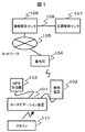
図1は、本発明の一実施形態が適用されたナビゲーションシステムの概略構成図である。本実施形態のナビゲーションシステムは、車両に搭載されるカーナビゲーション装置101と、地点情報や交通情報などの様々なデータをカーナビゲーション装置101に提供する情報提供センタ106と、全国の交通情報を収集し、専用回線108で接続された情報提供センタ106へ交通情報を提供する交通情報センタ107とを有する。カーナビゲーション装置101は、携帯電話102と接続され、この携帯電話102から無線基地局104およびネットワーク105を介して、情報提供センタ106と通信を行う。また、カーナビゲーション装置101は、GPS受信機103や、図示しない車速センサ、ジャイロセンサなどの車両に搭載された各種センサが接続可能に構成されている。なお、交通情報センタ107は、公知のコンピュータシステムにより実現可能である。
FIG. 1 is a schematic configuration diagram of a navigation system to which an embodiment of the present invention is applied. The navigation system according to the present embodiment collects the
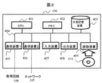
図2は、情報提供センタ106の概略構成図である。情報提供センタ106は、CPU401と、メモリ402と、ハードディスク装置等の外部記憶装置403と、CD−ROMやDVD−ROM等の可搬性を有する記憶媒体410からデータを読み取る読取装置409と、キーボードやマウス等の入力装置407と、モニタ等の出力装置408と、交通情報センタ107と通信する通信装置1(405)と、ネットワーク105を介して通信する通信装置2(406)と、これらの各装置を接続するバス404とを有する。情報提供センタ106は、このような構成を有するコンピュータシステムを複数備えていてもよい。そして、各々のコンピュータシステムを図示されていないネットワークインターフェースを用いて相互に接続することにより構成した分散ネットワークシステム上に構築することもできる。
FIG. 2 is a schematic configuration diagram of the
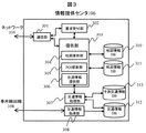
図3は、情報提供センタ106の機能ブロック図である。情報提供センタ106は、通信部301と、要求受付部302と、提供部303と、交通情報処理部307と、交通情報取得部308と、地図情報DB310と、地点情報DB311と、予測交通情報DB313と、交通情報DB312とを有する。
FIG. 3 is a functional block diagram of the
通信部301は、ネットワーク105を介して接続されたカーナビゲーション装置101と通信する。要求受付部302は、通信部301を介して接続されたカーナビゲーション装置101からの要求を受け付け、提供部303にその要求を伝達する。
The
提供部303は、カーナビゲーション装置101から通信で送られてきた要求に対応した情報を、通信部301を介してカーナビゲーション装置101に提供する。提供部303は、地図提供部304と、POI(Point of Interest)検索部305と、交通情報提供部306とを有する。
The providing
地図提供部304は、カーナビゲーション装置101から地図データを要求されたとき、要求時に指定された地点の位置を含む所定の領域の地図データを地図情報DB310から呼び出す。そして、ファイルとして格納した後、カーナビゲーション装置101に提供する。なお、地図情報DB310に格納されている地図情報は、後述するカーナビゲーション装置101の保持する地図情報220と同様の構成をとることができる。
When map data is requested from the
POI検索部305は、地点情報を要求されたとき、要求時にカーナビゲーション装置101から指定されたジャンル、電話番号、地点名称、住所などを元に地点情報DB311から該当するPOI(地点情報)を検索する。そして、その情報をファイルとして格納した後、カーナビゲーション装置101に提供する。
When the point information is requested, the
交通情報提供部306は、カーナビゲーション装置101から交通情報が要求されたとき、交通情報処理部307を介して、予測交通情報DB313又は交通情報DB312にアクセスし、要求された情報を探索する。そして、ファイルとして一旦格納した後、カーナビゲーション装置101に提供する。
When traffic information is requested from the
図4は、交通情報提供部306がカーナビゲーション装置101へ提供(ダウンロード)する交通情報の構成例を示す。ダウンロードする交通情報は、渋滞・旅行時間情報1030や事故・規制情報10640などを含む。
FIG. 4 shows a configuration example of traffic information provided (downloaded) to the
渋滞・旅行時間情報1030は、経路探索に利用される情報である。渋滞・旅行時間情報1030は、各リンクのリンクID1031ごとに、代表渋滞状況1032と、リンク旅行時間1033と、区間数1034と、区間情報1035とを含む。
The traffic jam /
リンクID1031は、対象リンクを一意に同定するための固有番号であり、地図情報DB310の地図情報のリンクIDと対応している。代表渋滞状況1032は、対象リンク全体の渋滞状況を示す渋滞情報であり、渋滞、混雑、順調の3レベルで示される。リンク旅行時間1033は、対象リンクの終端から始端までを走行するのに要する時間を示す情報である。区間数1034は、リンク内の区間の数である。区間情報1035は、対象リンク内の詳細な区間における渋滞状況を示す情報である。区間情報1035は、区間を特定するための区間先頭位置1037と、区間長1038と、当該区間における渋滞状況1036とを含む。
The
図5(A)は、渋滞・旅行時間情報1030の具体的な構成例を示す図である。図5(B)は、当該例におけるリンクの様子を示す図である。すなわち、リンクID1031が”1”のリンクの渋滞・旅行時間情報1030が、図5(A)のように構成される場合、区間数1034から、このリンクが、3つの区間からなることが分かる。そして、渋滞状況1036、先頭位置1037、区間長1038に関する情報から、区間1は200mの順調な区間であり、区間2は110mの混雑した区間であり、区間3は190mの渋滞した区間であることが分かる。なお。図5の例では区間数を3としているが、リンク内の渋滞の様子に応じて任意の区間数で表現できるものとする。
FIG. 5A is a diagram illustrating a specific configuration example of the traffic jam /
事故・規制情報1040は、地点情報1042と、リンクID1043と、事故・規制の種別1044とを含む。
The accident /
図3に戻って説明する。交通情報取得部308は、専用回線108で接続された交通情報センタ107から定期的に最新の交通情報をダウンロードし、交通情報DB312に格納する。交通情報処理部307は、交通情報DB312に蓄積された交通情報を用いて数分、数時間、もしくは数日先の交通状況を予測し、その予測情報を予測交通情報DB313に格納する。交通情報処理部307は、例えば以下のような方法を利用して近未来の交通状況の予測を行う。
(1)交通情報DB312に蓄積された交通情報を平日や休日などの日種別に分類し、分類ごとに同時間帯の旅行時間データもしくは渋滞データの平均値を求めて、その値を対象時間帯の予測値に適用する方法。
(2)現在の時系列データに対して、自己回帰、カルマンフィルター、ニューラルネットワークなどの手法で外挿する曲線(直線)を求め、近未来の交通状況を予測する時系列データ外挿法。
(3)過去の日の時系列データと当日の時系列データを比較して類似している日のデータを利用して予測する方法。
Returning to FIG. The traffic
(1) The traffic information stored in the
(2) A time series data extrapolation method that obtains a curve (straight line) to be extrapolated from the current time series data by a method such as autoregression, Kalman filter, neural network, etc., and predicts traffic conditions in the near future.
(3) A method of making predictions using data of similar days by comparing the time series data of the past day and the time series data of the current day.
交通情報処理部307は、以上のいずれかの手法を用いて数分先、数時間先、もしくは数日先の交通状況を予測して予測交通情報を生成し、予測交通情報DB313に格納する。
The traffic
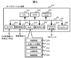
図6は、カーナビゲーション装置101の概略構成図である。カーナビゲーション装置101は、CPU201と、CPU201のワークエリアとして機能するRAM202と、カーナビゲーション装置101が提供可能な各機能を実現するための各種プログラムが格納されたフラッシュROM203と、携帯電話102を接続するための携帯電話IF(インターフェース)204と、各種情報を記憶しておくHDD(ハードディスク)210と、GPS受信機103や車速センサ,ジャイロセンサなどの各種センサを接続するためのセンサIF206と、操作ボタン群207と、リモコン110からの信号を受信するリモコン受光部205と、ディスプレイ208と、これらを相互に接続するためのバス209とを有する。
FIG. 6 is a schematic configuration diagram of the
HDD210に格納されている情報は、地図情報220と、渋滞レベル情報222と、燃費情報224と、交通情報226と、経路情報228とを含む。
Information stored in the
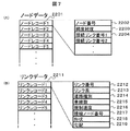
地図情報220は、2次メッシュ区画に区分されたメッシュごとに交差点に関するノードデータと、交差点をつなぐ道路に関するリンクデータを記憶している。2次メッシュ区画は、北緯1度当たり12分割、東経1度当たり8分割された、約10km四方の区域である。図7(A)は、2次メッシュ区画ごとに記憶されているノードデータ2201の構成例を示す図である。ノードデータは、ノードレコードごとに、ノードを一意に同定可能なノード番号2202と、緯度経度2203と、当該ノードと接続関係にあるリンクに関する接続リンク番号2204とを含む。図7(B)は、リンクデータの構成例を示す図である。リンクデータは、リンクレコード2211ごとに、リンクを一意に同定可能なリンク番号2212と、リンク長2213と、当該リンクが一般道路か高速道路かを判別可能な道路種別2214と、車線数2215と、規制速度2216と、接続ノード番号2217と、形状2218と、道路の傾きを示す勾配2219とを含む。
The
地図情報220は、予めカーナビゲーション装置101のHDD210に記憶されるようにしても良いし、情報提供センタ106よりダウンロードされ利用されるようにしてもよい。
The
渋滞レベル情報222は、後述する順調経路を探索する際のリンクコストの算出に用いる基本データである。渋滞レベル情報222は、一般道路、都市内高速道路、都市内高速道路の別に記憶されている。渋滞レベル情報222は、図8に示すように、走行可能な速度V[km/h]に対する単位長さ当たりの渋滞レベルC(V)2221に関する情報を含む。この単位長さ当たりの渋滞レベルC(V)2221は、基本的には速く走行できる区間ほど小さくなる。単位長さ当たりの渋滞レベルC(V)2221は、例えば、5つのレベルに分けられる。そして、走行可能速度Vが10km/h以下の区間を最大レベルの5とし、走行可能速度Vが40km/h以上の区間を最小レベルの1とする。なお、この渋滞レベルは5段階でなくてもよいし、各レベル値も0〜5の範囲に限った値でなくてもよい。
The traffic
渋滞レベル情報222は、予めカーナビゲーション装置101のHDD210に記憶されているようにしても良いし、情報提供センタ106よりダウンロードされ利用されるようにしてもよい。
The traffic
燃費情報224は、後述する燃料消費の少ない経路を探索する際のリンクコストの算出に用いる基本データである。燃費情報224は、図9に示すように、走行速度と道路勾配に対する燃費に関する情報を含む。燃費情報224に含まれる燃費は、次の傾向にある。道路勾配を一定として、走行速度−燃費の関係を見ると、基本的には走行速度が低いほど燃費は悪くなり、走行速度が高いほど燃費は良くなる。また、走行速度を一定として、道路勾配−燃費の関係を見ると、道路勾配が大きく(プラスの方向に)なるほど登り坂となるため、燃費は悪くなり、道路勾配が小さく(マイナスの方向に)なるほど下り坂となるため、燃費は良くなる。以上のように、車両の燃費は、車両の走行速度と道路勾配に依存しているため、燃費情報224は、このような走行速度と道路勾配に対応した燃費データ2241を含む。燃費情報224は、一般車両の平均的な特性を含むようにしてもよい。また、該カーナビゲーション装置を搭載する車両の燃費特性を含むようにしてもよい。また、燃費情報データ2241は、図9に示すように、1リットル当たりの走行距離として記憶されていてもよいし、単位長さ当たりの燃料消費量として記憶されていてもよい。
The
燃費情報224は、予めカーナビゲーション装置101のHDD210に記憶されているようにしても良いし、情報提供センタ106よりダウンロードされ利用されるようにしてもよい。
The
交通情報226は、情報提供センタ106よりダウンロードした情報であり、現況の交通情報を含む。
The
経路情報228は、探索した経路に関する情報である。経路情報228は、経路を構成するリンク情報やノード情報などを含む。
The
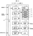
図10は、カーナビゲーション装置101の機能ブロック図である。カーナビゲーション装置101は、入力部600と、渋滞レベル修正部602と、自車位置取得部609と、交通情報取得部610と、リンクコスト算出部613と、標準経路探索部614と、経路比較情報生成部616と、修正経路探索部618と、表示部612と、情報記憶部605とを有する。
FIG. 10 is a functional block diagram of the
入力部600は、ユーザの操作信号を主制御部601に伝達する。入力部600は、操作ボタン群207やリモコン110、リモコン受光部205などで構成される。
The
記憶部605は、RAM202、フラッシュROM203、HDD210などで構成される。表示部612は、ディスプレイ208で構成され、各処理部からの指示に従って表示を行う。
The
自車位置取得部609は、GPS受信機103や車速センサなどで得られた信号より自車位置を計算する。
The own vehicle
交通情報取得部610は、携帯電話102などを介して情報提供センタ106より定期的に又はユーザからの要求に応じて、現在の交通状況を含む交通情報をダウンロードする。そして、ダウンロードした交通情報を記憶部605に記憶させる。
The traffic
渋滞レベル修正部602は、ユーザが入力部600を利用して入力した順調速度を元に、記憶部605に記憶されている渋滞レベル情報222の修正を行う。
The traffic congestion
リンクコスト算出部613は、自車位置取得部609で計算された自車位置の情報と、交通情報取得部610が受信した交通情報と、渋滞レベル情報222と、燃費情報222と、地図情報224と、入力部600を介してユーザが入力した目的地や探索条件の情報と、に基づき各リンクのリンクコストを計算する。
The link
標準経路探索部614は、リンクコスト算出部613で計算された各リンクのリンクコストを元に、ダイクストラ法などを利用して自車位置から目的地までのコストが最小の経路(以下「標準経路」と呼ぶ)を探索する。また、探索した経路を表示部612に表示する。
Based on the link cost of each link calculated by the link
修正経路探索部618は、探索された経路に対する修正指示を受け付けた場合、修正指示の内容を反映した経路(以下、「修正経路」と呼ぶ)を探索する。また、探索した経路を表示部612に表示する。修正経路探索部618は、経路修正指示を何度でも受付可能であり、受け付ける度に修正経路を探索する。
When receiving a correction instruction for the searched route, the correction
経路比較情報生成部616は、標準経路探索部614が探索した標準経路と、修正経路探索部618が探索した修正経路の、経路情報(経路長や所要時間、経路上の渋滞長、燃料消費量など)の差分を計算して、ユーザが両経路を比較しやすくするための情報を生成して表示部612に表示する。
The route comparison
上記の各処理部の機能は、CPU201がメモリ202にロードされたプログラムを実行することにより達成される。
The functions of the above processing units are achieved by the
[動作の説明] 次に、上記のように構成されるカーナビゲーション装置101の動作について説明する。図11は、カーナビゲーション装置101の動作の処理の流れを示すフロー図である。このフローは、ユーザからリモコン110や操作ボタン群207を介して、経路探索要求を受け付けたときに開始する。
[Description of Operation] Next, the operation of the
(ステップ500) まず、主制御部601は、ユーザの希望する順調速度(順調速度の閾値)の設定を行う。具体的には、主制御部601は、図12に示すように、順調速度の設定画面900をディスプレイ208に表示する。なお、ユーザから順調速度の設定要求を受け付けた場合に、設定画面900を表示するようにしてもよい。設定画面900には、一般道路、都市内高速道路、都市間高速道路それぞれについて、現在設定されている順調速度が表示される。順調速度の初期値は、それぞれ40km/h、60km/h、80km/hとなっている。
(Step 500) First, the
主制御部601は、これらの値の変更要求をリモコン110等を介して受け付ける。そして、変更要求された値をディスプレイ208に表示する。主制御部601は、ユーザから順調速度の変更の確定要求を受け付けると、そのとき指定されている値で順調速度を設定する。
The
(ステップ505) 次に、渋滞レベル修正部602は、記憶部605に格納されている渋滞レベル情報222を修正する。具体的には、設定された順調速度以上において、単位長さ当たりの渋滞レベルが最小レベルになるように渋滞レベル情報222を修正する。例えば、走行速度と渋滞レベルの関係が図8に示したようになっている場合において、順調速度が40km/hから50km/hに変更された場合は、図13に示すようになる。すなわち、40〜50km/hの渋滞レベルを一つ上げて、走行速度50km/h以上においてのみ、単位長さ当たりの渋滞レベルが最小の1になるように修正する。そして、渋滞レベル修正部602は、修正された渋滞レベル情報222を記憶部605に記憶させる。
(Step 505) Next, the traffic
(ステップ510) 次に、主制御部601は、探索条件を設定する。具体的には、主制御部601は、まず、図12(B)に示すように、設定画面905をディスプレイ208に表示する。画面905には、例えば、目的地までの最短距離経路を探索する“走行距離短く”906と、目的地までの最短所要時間経路を探索する“到着時間速く”907と、ステップ500で設定された順調速度以上の速度で目的地まで安定的に走行できる経路を探索する“順調区間多く”908と、燃料消費量を最小とする“燃料消費少なく”909等の探索条件が表示される。主制御部601は、リモコン110や操作ボタン群207などを介して、4つの探索条件のなかからひとつを選択する要求を受け付けると、選択された内容で探索条件を設定する。
(Step 510) Next, the
(ステップ520) 次に、リンクコスト算出部613は、ステップ510で設定された探索条件を満足する標準経路が探索されるように、リンクコストを計算する。リンクコスト算出部613は、以下の(式1)により、リンクコストを計算する。
(Step 520) Next, the link
(式1) リンクコスト=α1×リンク長+α2×リンク旅行時間+α3×リンク渋滞レベル+α4×燃料消費量 ここで、α1、α2、α3、α4はコスト係数である。(式1)の右辺のリンク長は、各リンクの長さを示し、記憶部605の地図情報220に含まれている“リンク長”が代入される。(式1)の右辺のリンク旅行時間は、対象リンクにおける走行所要時間を示し、記憶部605の交通情報226に含まれる“リンク旅行時間”が代入される。(式1)の右辺のリンク渋滞レベルと燃料消費量は、それぞれ渋滞レベル情報222と燃費情報222をもとに計算された値が代入される。これらについては後述する。
(Expression 1) Link cost = α1 × link length + α2 × link travel time + α3 × link congestion level + α4 × fuel consumption Here, α1, α2, α3, and α4 are cost coefficients. The link length on the right side of (Expression 1) indicates the length of each link, and “link length” included in the
(式1)の右辺の第1項から第4項は、ステップ510で設定した経路探索条件に対応している。第1項を重視すれば“走行距離短く”を満足する経路が探索され、第2項を重視すれば“到着時間速くを”満足する経路が探索され、第3項を重視すれば“順調区間多く”を満足する経路が探索され、第4項を重視すれば“燃料消費少なく”を満足する経路が探索される。従って、リンクコスト算出部613は、ユーザが選択した探索条件に対応した項目の重みが大きくなるように、コスト係数を決定してリンクコストを計算することになる。
The first to fourth terms on the right side of (Expression 1) correspond to the route search conditions set in step 510. If the first term is emphasized, a route satisfying “short travel distance” is searched, if the second term is emphasized, a route satisfying “fast arrival time” is searched, and if the third term is emphasized, “smooth section” A route satisfying “many” is searched, and if the fourth term is emphasized, a route satisfying “low fuel consumption” is searched. Accordingly, the link
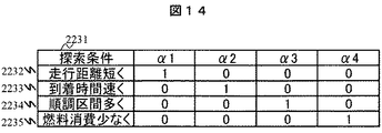
図14は、各探索条件が選択された場合のコスト係数の設定値の一例を示している。例えば、ユーザが探索条件2231として“走行距離短く”2232を選択した場合は、α1のみを1に設定し、それ以外の係数を0とする。これにより、(式1)の右辺の第1項のみが残るため、単純に距離最短の経路が探索されることになる。また、“到着時間速く”2233が選択された場合は、α2のみを1に設定し、それ以外の係数を0とする。同様に“順調区間多く”3334、“燃料消費少なく”2235が選択された場合は、それぞれα3、α4のみを1に設定し、それ以外を0とする。
FIG. 14 shows an example of the set value of the cost coefficient when each search condition is selected. For example, when the user selects “short travel distance” 2232 as the
次に、(式1)の右辺のリンク渋滞レベルの算出方法について、図15を用いて説明する。リンク渋滞レベルは、渋滞レベル情報222と交通情報226とを用いて求められる。あるリンクのリンク渋滞レベルを求める際は、まずリンクを微小間隔d(例えば10m)の区間2241に分割する。そして、各微小区間2241における渋滞状況を交通情報226の区間情報1035より得る。渋滞状況が“渋滞”の場合は10km/h(V=10)、“混雑”の場合は20km/h(V=20)、“順調”の場合は当該リンクの規制速度(V=規制速度)で走行できるものと仮定する。そして、渋滞レベル情報222より、渋滞レベルC(V)を求め、C(V)・dより区間渋滞レベルを計算して、リンク全体で累積することで、当該リンクのリンク渋滞レベルとする。
Next, a method for calculating the link congestion level on the right side of (Expression 1) will be described with reference to FIG. The link traffic congestion level is obtained using the traffic
もしくは、次のようにしてリンク渋滞レベルを求めるようにしてもよい。まず、交通情報226のリンク旅行時間と地図情報220のリンク長より(リンク長)/(リンク旅行時間)からリンクの平均速度を求める。このリンクの平均速度を対象リンクにおける走行可能な速度Vと仮定して、渋滞レベル情報222より、単位長さ当たりの渋滞レベルC(V)を読み込み、C(V)・リンク長より対象リンクの渋滞レベルを計算する。これらのいずれかの方法を利用して(式1)右辺のリンク渋滞レベルを算出する。
Alternatively, the link congestion level may be obtained as follows. First, an average link speed is obtained from (link length) / (link travel time) from the link travel time of the
次に、(式1)の右辺に含まれる燃料消費量の算出方法について説明する。各リンクの燃料消費量は、記憶部605に記憶されている燃費情報224と、交通情報226と、地図情報220とにより計算する。まず、地図情報220より各リンクの勾配情報を読み込む。また、各リンクの走行可能な速度を交通情報226のリンク旅行時間と地図情報220のリンク長より(リンク長)/(リンク旅行時間)で求める。そして、各リンクの勾配と走行可能な速度から燃費情報224より燃費を読み込み、下記(式2)で各リンクの燃料消費量を計算する。
(式2) 燃料消費量=(リンク長)/(燃費)
以上により、(式1)の右辺に含まれる燃料消費量を計算することができる。なお、燃費情報224が、1リットル当たりの走行可能距離ではなく、単位長さ当たりの燃料消費量となっている場合は、(リンク長)×(単位長さ当たりの燃料消費量)として、対象リンクにおける燃料消費量を算出することが可能である。
Next, a method for calculating the fuel consumption included in the right side of (Equation 1) will be described. The fuel consumption amount of each link is calculated from the
(Formula 2) Fuel consumption = (link length) / (fuel consumption)
As described above, the fuel consumption included in the right side of (Equation 1) can be calculated. In addition, when the
(ステップ530) 以上のようにして、リンクコストが求まると、次に、標準経路探索部614は、上記で算出されたリンクコストに基づき標準経路を探索する。標準経路の探索は、例えば、自車位置と目的地とを結ぶ直線を対角線とする矩形領域、もしくは出発地と目的地を結ぶ直線を半径とする円領域に係る2次メッシュ内に存在するリンクを対象にダイクストラ法を用いて計算する。ダイクストラ法によれば、出発地(自車位置)から目的地までの経路(リンク列)のなかでリンクコストの累積値が最小となる経路を見つけることができる。そして、標準経路探索部614は、この経路探索の結果を経路情報228として記憶部605に格納する。
(Step 530) When the link cost is obtained as described above, the standard route search unit 614 next searches for the standard route based on the link cost calculated above. The search for the standard route is performed by, for example, a link existing in a quadratic area having a rectangular area with a straight line connecting the vehicle position and the destination as a diagonal line or a circular area having a radius with a straight line connecting the starting point and the destination. Is calculated using the Dijkstra method. According to the Dijkstra method, it is possible to find a route having a minimum accumulated link cost among routes (link train) from a departure point (own vehicle position) to a destination. Then, the standard route search unit 614 stores the result of this route search in the
また、標準経路探索部614は、標準経路の距離、所要時間、経路上の渋滞距離、および燃料消費量(以降ではこれらを総称して経路の特長量と呼ぶ)を計算する。標準経路の距離については、自車位置から目的地までの標準経路を構成するリンクのリンク長の総和により求める。また、所要時間については、各リンクのリンク旅行時間の総和により求める。また、経路上の渋滞距離については、各リンクの区間情報に基づき渋滞度が“渋滞”になっている区間の長さの総和、もしくは、ステップ500で設定した順調速度未満の走行速度となる区間長の総和により求める。この渋滞距離については経路全体に占める渋滞割合としても構わない。渋滞割合の場合は、渋滞距離/経路長より求める。また、燃料消費量については、(式2)で算出される各リンクの燃料消費量の総和により求める。 The standard route search unit 614 calculates a standard route distance, a required time, a congestion distance on the route, and a fuel consumption amount (hereinafter collectively referred to as a route feature amount). The distance of the standard route is obtained from the sum of the link lengths of the links constituting the standard route from the vehicle position to the destination. The required time is obtained from the sum of the link travel times for each link. As for the traffic jam distance on the route, based on the zone information of each link, the total length of the zones where the traffic jam degree is “Junk” or the zone where the running speed is less than the smooth speed set in Step 500 Calculated by the total length. This traffic distance may be a traffic congestion ratio in the entire route. In the case of the traffic congestion ratio, the traffic congestion distance / route length is obtained. Further, the fuel consumption is obtained by the sum of the fuel consumption of each link calculated by (Equation 2).
(ステップ540) 次に、標準経路探索部614は、これらの情報を経路情報228として記憶部605に記憶するとともに、ディスプレイ208に表示する。図16に表示画面の例を示す。図16の表示画面910において、符号1140は自車位置であり、符号1142は探索した標準経路、符号1144は目的地、符号1130は標準経路に関する情報である。
(Step 540) Next, the standard route searching unit 614 stores these pieces of information as
なお、ここで示した特長量のうち渋滞距離については、逆に順調距離を計算して表示するようにしても構わない。順調距離の計算は、ステップ500で設定した順調速度以上で走行可能な区間の長さの総和で求めることができる。また、この順調距離は順調割合として表示するようにしてもよい。順調割合は順調距離/経路長で求めることができる。 Note that, for the traffic jam distance among the feature amounts shown here, the smooth distance may be calculated and displayed. The smooth distance can be calculated by the sum of the lengths of sections that can travel at the smooth speed or higher set in step 500. Further, this smooth distance may be displayed as a smooth ratio. The smoothing rate can be obtained from the smoothing distance / path length.
(ステップ545) 次に、主制御部601は、ユーザから標準経路を誘導経路として採用するか否かの選択を受け付ける。ユーザが標準経路を誘導経路として選択した場合(つまり、リモコン110などを用いて決定ボタンが押下された場合)(ステップ545でYes)、主制御部601は、標準経路を用いて、経路誘導を開始する(ステップ570)。
(Step 545) Next, the
(ステップ550) ユーザがこの標準経路に満足せず、標準経路が選択されなかった場合(ステップ545でNo)、修正経路探索部618は、修正経路を探索する。
(Step 550) When the user is not satisfied with the standard route and the standard route is not selected (No in Step 545), the corrected
具体的には、まず、修正経路探索部618は、図16に示すように、修正項目の設定画面915を表示する。設定画面915には、経路を修正する経路修正ボタン1100〜1114が表示される。ボタン1100、1102は、標準経路に対してそれぞれ距離を“短く”、“長く”するように経路修正を行う修正ボタンである。また、ボタン1104、1106は、標準経路に対してそれぞれ所要時間を“短く”、“長く”するように修正するボタンである。ボタン1108、1110は、標準経路に対してそれぞれ渋滞距離を“少なく”、“多く”するように修正するボタンである。ボタン1112、1114は、標
準経路に対してそれぞれ燃料消費量を“少なく”、“多く”するように修正するボタンである。これらのいずれかのボタン1100〜1114がユーザによりリモコン110等を介して押下されると、修正経路探索部618は、それを反映した修正経路を探索する。なお、修正経路探索部618は、ユーザがいずれかの経路修正ボタンを1回押下するごとに、修正経路を1本探索する。以降ではこの経路を探索された順に修正経路1、修正経路2、修正経路3、・・・と呼ぶ。
Specifically, first, the correction
ここで、修正経路探索部618が、修正経路1を探索する処理について詳細に説明する。まず、標準経路1142のみ表示されている画面910において、ユーザによりいずれかの経路修正ボタンが1回押下されると、リンクコスト算出部613は、どのボタンが押下されたのかを認識する。そして、“距離”、“所要時間”、“渋滞”、“燃料消費”の各項目に対応した(式1)右辺の第1項から第4項の重みの変更を行う。この重みの変更は、(式1)右辺の第1項から第4項の各コスト係数α1からα4の値を調整することで実現される。図17は、各経路修正ボタンが選択された場合のコスト係数の変化量を示している。この変化量のデータは、予め記憶部605に記憶されている。コスト係数の初期値(つまり、標準経路の探索で用いたコスト係数)をそれぞれ{α1、α2、α3、α4}とすると、修正経路1の探索では、コスト係数として、図17に示すコスト係数の変化量2241を加味した{α1+Δα1、α2+Δα2、α3+Δα3、α4+Δα4}を用いる。そして、リンクコスト算出部613は、(式1)より新たにαリンクコストを計算する。修正経路探索部618は、このように計算されたリンクコストを用いて、経路探索を行う。なお、ここで、各コスト係数の値のとりうる範囲は0以上1未満とし、0≦αi+Δαi≦1(i=1、2、3、4)を満足しないコスト係数になる場合には、対応する経路修正ボタンを押下できないように、もしくは押下しても機能しないようにしておいてもよい。
Here, a process in which the corrected
(ステップ560) 以上のようにして、修正経路が探索されると、経路比較情報生成部616は、標準経路と修正経路1とを比較するための比較情報を生成して画面に表示する。ここで、比較情報とは、標準経路と修正経路1の各経路の特長量、すなわち距離と、所要時間と、経路上の渋滞長と、燃料消費量の差分を示す情報である。修正経路1と比較情報の表示例を図18に示している。なお、図18において図16と同符号の要素は、同一のものであることを意味している。図18の経路1152は、修正経路1を示し、符号1154は両経路の比較情報を示している。符号1154の比較情報における各項目の数値は、それぞれ標準経路の特長量からの増減分を示している。すなわち、図18の例では修正経路1は標準経路に対して距離が−5km(つまり、20km)、所要時間が−5分(つまり、30分)、経路上の渋滞が+2km(つまり、5km)、燃料消費量が+0.6リットル(つまり、3.8リットル)であることを示している。このように、比較情報として標準経路に対する特性値の差を“+”、“−”を付して示すことでユーザは経路の優劣を一目で認識できる。
(Step 560) When the corrected route is searched as described above, the route comparison
次に、図18の画面においてユーザが更に経路修正ボタンを押下した場合の2回目以降の修正処理について説明する。2回目以降の修正処理も基本的には1回目と同様に行うことになる。ユーザが経路修正ボタンのいずれかを押下して修正経路2の探索を要求した場合、リンクコスト算出部613は、前記修正経路1の探索に用いたコスト係数を{α1'、α2'、α3'、α4'}とすると、修正経路2の探索に用いるコスト係数を{α1'+Δα1、α2’+Δα2、α3’+Δα3、α4’+Δα4}として、リンクコストを計算する。そして、修正経路探索部618は、このように計算されたリンクコストを用いて、経路探索を行う。
Next, the second and subsequent correction processing when the user further presses the route correction button on the screen of FIG. 18 will be described. The second and subsequent correction processing is basically performed in the same manner as the first time. When the user presses one of the route correction buttons to request a search for the
なお、Δα1、Δα2、Δα3、Δα4の変化量は、修正経路1の場合と同様に、図17に示した値である。そして、経路比較情報生成部616は、修正経路1の場合と同じ要領で、標準経路と修正経路2との比較情報を生成して画面に表示する。
Note that the amounts of change of Δα1, Δα2, Δα3, and Δα4 are the values shown in FIG. Then, the route comparison
修正経路2の画面表示の例を図19に示している。ここで、修正経路1の情報に関しては、情報記憶部605の経路情報228には記憶されているが、画面表示はしないようにする。つまり、修正経路2と標準経路のみの情報を画面表示する。3回目以降に関しては、2回目の修正と同様の手順であるため説明を省略する。
An example of the screen display of the
次に、以上の標準経路の探索から修正経路の探索までのコスト係数変更の流れについて具体的な例を挙げて説明する。まず、標準経路を探索する際に図13の経路探索条件選択画面905においてユーザが“順調区間多く”を選択したとする。この場合、図14に示したように、コスト係数は{α1、α2、α3、α4}={0、0、1、0}である。リンクコスト算出部613は、これを用いて(式1)よりリンクコストを計算する。そして、標準経路探索部614は、このリンクコストを用いて標準経路を探索する。そして、標準経路のみを表示している図16の画面において、ユーザが所要時間の“短く”を1回選択した場合、図17の変化量を加味して、{α1、α2、α3、α4}={0、0.2、1、0}として、リンクコスト算出部613は、(式1)よりリンクコストを計算する。そして、修正経路探索部618は、修正経路1を探索する。更に、ユーザが燃料消費量も加味したいと考え、燃料消費の“少なく”を選択した場合、図17の変化量を加味して、リンクコスト算出部613は、{α1、α2、α3、α4}={0、0.2、1、0.2}として、(式1)よりリンクコストを計算する。そして、修正経路探索部618は、修正経路2を探索する。3回目以降に関しても同様に図17のコスト係数の変化量を加味して、修正経路3、修正経路4・・・、と経路探索が行われる。
Next, the flow of changing the cost coefficient from the search for the standard route to the search for the corrected route will be described with a specific example. First, when searching for a standard route, it is assumed that the user selects “many smooth sections” on the route search
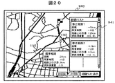
次に図19の画面において、経路リスト表示ボタン1170が押下された場合の処理について説明する。経路リスト表示ボタン1170がユーザにより押下されると、主制御部605は、記憶部605に記憶されている経路情報228を読み込み、これまでに探索した修正経路のリストを作成して図20のように画面表示する。図20の画面940において右側に表示されているリスト941は各修正経路の比較情報である。主制御部605は、ユーザによりリモコン110や操作ボタン群207を介していずれかひとつの比較情報が選択されると、その比較情報に対応した修正経路を画面に表示する。そして、選択の決定ボタンが押されると、主制御部605は、当該選択された経路により目的地までの誘導を開始する(ステップ570)。
Next, processing when the route
以上、本発明の一実施形態について説明した。 The embodiment of the present invention has been described above.
上記実施形態のカーナビゲーション装置によれば、交通情報を配信するセンタから最新の交通情報を入手し、現在の交通状況に基づいてリンクコストを求める。そして、求めたリンクコストを用いて経路探索を行う。したがって、より実際の交通状況を考慮した経路探索が行われる。すなわち、実際に、より順調に走行できる経路が探索される。 According to the car navigation device of the above embodiment, the latest traffic information is obtained from the center that distributes the traffic information, and the link cost is obtained based on the current traffic situation. Then, a route search is performed using the obtained link cost. Therefore, a route search is performed in consideration of actual traffic conditions. That is, a route that can actually travel more smoothly is searched.
また、上記実施形態のカーナビゲーション装置によれば、ユーザが入力した順調速度の情報を利用してHDD210に記憶されている渋滞レベル情報222を修正する。そして、この渋滞レベル情報222を用いてリンクコストを計算し、このリンクコストを経路探索に用いる。したがって、ユーザが入力した順調速度以上の速度で安定的に目的地まで走行できる経路を探索することができ、よりユーザの好み通りの経路を探索できる。
Further, according to the car navigation apparatus of the above-described embodiment, the
また、上記実施形態のカーナビゲーション装置によれば、HDD210に記憶されている燃費情報222と、情報提供センタ106より受信した交通情報226と、地図情報220に含まれている各リンクの勾配情報を用いて、各リンクの燃料消費量を推定し、この燃料消費量をリンクコストとして、標準経路探索部614が経路を探索する。したがって、燃料消費量が最小の経路を提供することができ、よりユーザの好み通りの経路を探索できる。
Further, according to the car navigation apparatus of the above embodiment, the
また、上記実施形態のカーナビゲーション装置によれば、標準経路と、修正経路と、標準経路と修正経路との特長量の差分を示す比較情報と、を表示部612に表示する。したがって、ユーザは経路比較を容易に行うことができると共に、経路修正指示の入力を繰り返し行うことで好みを満足する経路を見つけることができる。
Further, according to the car navigation device of the above-described embodiment, the standard route, the correction route, and the comparison information indicating the difference in the feature amount between the standard route and the correction route are displayed on the
なお、上記で説明したカーナビゲーション装置が行う各処理は、情報提供センタなどのサーバ側が行うようにしてもよい。そして、カーナビゲーション装置は、サーバにより処理された情報を入手して、表示するようにしてもよい。 Each process performed by the car navigation device described above may be performed by a server such as an information providing center. Then, the car navigation device may obtain and display information processed by the server.
また、上記実施形態は、本発明の要旨の範囲内で様々な変形が可能である。例えば、上記では、本発明をカーナビゲーション装置に適用した例について説明したが、本発明は車載用以外のナビゲーション装置にも適用することができる。 The above-described embodiment can be variously modified within the scope of the gist of the present invention. For example, in the above description, an example in which the present invention is applied to a car navigation device has been described. However, the present invention can also be applied to a navigation device other than a vehicle-mounted navigation device.
101・・・カーナビゲーション装置、102・・・携帯電話、103・・・GPS受信機、104・・・基地局、105・・・ネットワーク、106・・・情報提供センタ、107・・・交通情報センタ、108・・・専用回線、110・・・リモコン、201・・・CPU、202・・・RAM、203・・・フラッシュROM、204・・・携帯電話IF、205・・・リモコン受光部、206・・・センサIF、207・・・操作ボタン群、208・・・ディスプレイ、209・・・バス、210・・・HDD、220・・・地図情報、222・・・渋滞レベル情報、224・・・燃費情報、226・・・交通情報、228・・・経路情報、301・・・通信部、302・・・要求受付部、303・・・提供部、304・・・地図提供部、305・・・POI探索部、306・・・交通情報提供部、307・・・交通情報処理部、308・・・交通情報取得部、310・・・地図情報DB、311・・・地点情報DB、312・・・交通情報DB、313・・・予測交通情報DB、401・・・CPU、402・・・メモリ、403・・・外部記憶装置、404・・・バス、405・・・通信装置1、406・・・通信装置2、407・・・入力装置、408・・・出力装置、409・・・読取装置、410・・・記憶媒体、600・・・入力部、602・・・渋滞レベル修正部、605・・・記憶部、609・・・自車位置取得部、610・・・交通情報取得部、612・・・表示部、613・・・リンクコスト算出部、614・・・標準経路探索部、616・・・経路比較情報生成部、618・・・修正経路探索部
DESCRIPTION OF
Claims (13)
現況の交通情報を配信するセンタから交通情報を入手する情報入手手段と、
速度閾値の入力を受け付ける速度閾値受付手段と、
前記情報入手手段で入手した現況の交通情報と前記速度閾値とを用いてリンクコストを求めるリンクコスト算出手段と、
前記リンクコスト算出手段により算出されたリンクコストを用いて経路を探索する経路探索手段と
を有することを特徴とする経路探索装置。 In the route search device,
Information acquisition means for acquiring traffic information from a center that distributes current traffic information;
A speed threshold receiving means for receiving an input of a speed threshold;
A link cost calculating means for obtaining a link cost using the current traffic information obtained by the information obtaining means and the speed threshold;
A route search device comprising: route search means for searching for a route using the link cost calculated by the link cost calculation means.
前記情報入手手段で入手した現況の交通情報を用いて、各リンクの推定走行速度を求める走行速度推定手段を有し、
前記リンクコスト算出手段は、
前記推定走行速度が前記速度閾値より大きいリンクが経路に採用されやすいように、リンクコストを重み付けする
ことを特徴とする経路探索装置。 The claim 1, further comprising:
Using the current traffic information obtained by the information obtaining means, having a traveling speed estimating means for obtaining an estimated traveling speed of each link;
The link cost calculation means
A route search device characterized by weighting link costs so that a link having the estimated traveling speed larger than the speed threshold is easily adopted in the route.
前記走行速度推定手段は、
前記現況の交通情報に含まれる渋滞度と、当該渋滞度に応じて予め定められた走行速度とを用い、各リンクの推定走行速度を求める
ことを特徴とする経路探索装置。 In claim 2,
The travel speed estimating means includes
A route search device characterized in that an estimated travel speed of each link is obtained using a traffic congestion level included in the current traffic information and a travel speed predetermined according to the traffic congestion level.
走行速度が大きくなるほど小さくなるように対応付けられた渋滞レベルを含む渋滞レベル情報を記憶する手段を有し、
前記リンクコスト算出手段は、
前記渋滞レベル情報を、前記速度閾値より大きい走行速度の渋滞レベルが最少のレベルになるように修正した後、修正された当該渋滞レベル情報を用いてリンクコストを算出し、
前記経路探索手段は、前記リンクコスト算出手段により算出されたリンクコストを用いて総コストが最少となる経路を探索する
することを特徴とする経路探索装置。 The claim 1, further comprising:
Means for storing traffic level information including a traffic level associated with the traffic speed so as to decrease as the traveling speed increases;
The link cost calculation means
After correcting the traffic level information so that the traffic level of the traveling speed greater than the speed threshold becomes the minimum level, the link cost is calculated using the corrected traffic level information,
The route search device, wherein the route search device searches for a route having a minimum total cost using the link cost calculated by the link cost calculation device.
前記経路探索手段により探索された経路における前記速度閾値未満もしくは前記速度閾値以上で走行可能な区間の長さに関する情報を表示する表示手段を有する
ことを特徴とする経路探索装置。 In any one of Claims 1-4, Furthermore,
A route search apparatus, comprising: a display unit configured to display information relating to a length of a section that can be traveled at a speed that is less than or greater than the speed threshold in the route searched by the route search means.
地図情報と燃費情報とを記憶する手段と、
現況の交通情報を配信するセンタから交通情報を入手する情報入手手段と、
前記情報入手手段で入手した現況の交通情報と前記地図情報と前記燃費情報とを用いてリンクコストを求めるリンクコスト算出手段と、
前記リンクコスト算出手段により算出されたリンクコストを用いて経路を探索する経路探索手段と
を有することを特徴とする経路探索装置。 In the route search device,
Means for storing map information and fuel consumption information;
Information acquisition means for acquiring traffic information from a center that distributes current traffic information;
A link cost calculating means for obtaining a link cost using the current traffic information obtained by the information obtaining means, the map information, and the fuel consumption information;
A route search device comprising: route search means for searching for a route using the link cost calculated by the link cost calculation means.
前記地図情報は、道路勾配を示す情報を含み、
前記燃費情報は、道路勾配と走行速度に対する燃費を示す情報であり、
前記リンクコスト算出手段は、
前記地図情報から各リンクの道路勾配を求め、
前記情報入手手段で入手した現況の交通情報から各リンクの推定走行速度を求め、
前記燃費情報を用いて各リンクの前記道路勾配と前記推定走行速度とに対応する燃料消費量を求め、
前記燃料消費量が少ない経路が探索されるようにリンクコストを算出する
ことを特徴とする経路探索装置。 In claim 6,
The map information includes information indicating a road gradient,
The fuel efficiency information is information indicating the fuel efficiency with respect to the road gradient and the traveling speed,
The link cost calculation means
Obtain the road slope of each link from the map information,
Obtain the estimated traveling speed of each link from the current traffic information obtained by the information obtaining means,
Using the fuel consumption information, obtain the fuel consumption corresponding to the road gradient and the estimated traveling speed of each link,
A route search apparatus that calculates a link cost so that a route with a small amount of fuel consumption is searched.
前記燃費情報は、道路勾配と走行速度に対する単位長さ当たりの燃料消費量を示す情報であり、
前記リンクコスト算出手段は、前記地図情報から各リンクの道路勾配を求め、
前記情報入手手段で入手した現況の交通情報から各リンクの推定走行速度を求め、
前記燃費情報から、各リンクについて、前記道路勾配と前記推定走行速度とに対応する前記単位長さ当たりの燃料消費量を求め、
求めた燃料消費量と各リンクのリンク長との積により燃料消費量を求め、
前記燃料消費量が少ない経路が探索されるようにリンクコストを算出する
ことを特徴とする経路探索装置。 In claim 6,
The fuel consumption information is information indicating fuel consumption per unit length with respect to road gradient and travel speed,
The link cost calculation means obtains a road gradient of each link from the map information,
Obtain the estimated traveling speed of each link from the current traffic information obtained by the information obtaining means,
From the fuel consumption information, for each link, obtain the fuel consumption per unit length corresponding to the road gradient and the estimated traveling speed,
Calculate the fuel consumption by the product of the calculated fuel consumption and the link length of each link.
A route search apparatus that calculates a link cost so that a route with a small amount of fuel consumption is searched.
前記経路探索手段により探索された経路の燃料消費量に関する情報を表示する表示手段を有することを特徴とする経路探索装置。 In claim 6, further:
A route search apparatus comprising display means for displaying information relating to fuel consumption of the route searched by the route search means.
前記表示手段は、前記経路を構成する各リンクの燃料消費量の総和を表示することを特徴とする経路探索装置。 In claim 9,
The route search device, wherein the display means displays a sum of fuel consumption of each link constituting the route.
探索条件を設定する手段と、
前記探索条件に従って標準経路を探索する経路探索手段と、
前記標準経路を表示する表示手段と、
前記標準経路の修正指示を受け付ける経路修正受付手段とを有し、
前記経路探索手段は、さらに、
前記経路修正受付手段により受け付けた修正指示に従い修正経路を探索し、
前記表示手段は、前記標準経路と修正経路とを表示するとともに、
前記標準経路と前記修正経路とを比較する比較情報を表示する
ことを特徴とする経路探索装置。 In the route search device,
Means for setting search conditions;
Route search means for searching for a standard route according to the search conditions;
Display means for displaying the standard route;
Route correction receiving means for receiving a correction instruction of the standard route,
The route search means further includes:
Search the correction route according to the correction instruction received by the route correction receiving means,
The display means displays the standard route and the corrected route,
A route search apparatus for displaying comparison information for comparing the standard route and the corrected route.
前記比較情報は、前記標準経路と前記修正経路との差に関する情報である
ことを特徴とする経路探索装置。 In claim 11,
The comparison information is information regarding a difference between the standard route and the corrected route.
前記経路修正受付手段は、さらに、修正経路の修正指示を受け付け、
前記経路探索手段は、
前記経路修正受付手段により受け付けた修正指示に従い、再度、修正経路を探索し、
前記表示手段は、前記標準経路と再度探索された前記修正経路とを表示するとともに、前記標準経路と当該修正経路とを比較する比較情報を表示する
ことを特徴とする経路探索装置。 In claim 11,
The route correction receiving means further receives a correction route correction instruction,
The route search means includes
In accordance with the correction instruction received by the route correction receiving means, search again for a correction route,
The display means displays the standard route and the corrected route searched again, and displays comparison information for comparing the standard route and the corrected route.
Priority Applications (1)
| Application Number | Priority Date | Filing Date | Title |
|---|---|---|---|
| JP2009255657A JP4934711B2 (en) | 2009-11-09 | 2009-11-09 | Route search device |
Applications Claiming Priority (1)
| Application Number | Priority Date | Filing Date | Title |
|---|---|---|---|
| JP2009255657A JP4934711B2 (en) | 2009-11-09 | 2009-11-09 | Route search device |
Related Parent Applications (1)
| Application Number | Title | Priority Date | Filing Date |
|---|---|---|---|
| JP2004283440A Division JP4502766B2 (en) | 2004-09-29 | 2004-09-29 | Route search device |
Publications (2)
| Publication Number | Publication Date |
|---|---|
| JP2010032541A true JP2010032541A (en) | 2010-02-12 |
| JP4934711B2 JP4934711B2 (en) | 2012-05-16 |
Family
ID=41737142
Family Applications (1)
| Application Number | Title | Priority Date | Filing Date |
|---|---|---|---|
| JP2009255657A Active JP4934711B2 (en) | 2009-11-09 | 2009-11-09 | Route search device |
Country Status (1)
| Country | Link |
|---|---|
| JP (1) | JP4934711B2 (en) |
Cited By (6)
| Publication number | Priority date | Publication date | Assignee | Title |
|---|---|---|---|---|
| WO2011111107A1 (en) * | 2010-03-11 | 2011-09-15 | 三菱電機株式会社 | Navigation device |
| JP2012093298A (en) * | 2010-10-28 | 2012-05-17 | Clarion Co Ltd | Route guidance device |
| WO2015111507A1 (en) * | 2014-01-27 | 2015-07-30 | アイシン・エィ・ダブリュ株式会社 | Route searching system, route searching method, and computer program |
| JP2015141054A (en) * | 2014-01-27 | 2015-08-03 | アイシン・エィ・ダブリュ株式会社 | Route guidance system, route guidance method, and computer program |
| JP2015184110A (en) * | 2014-03-24 | 2015-10-22 | 株式会社デンソー | Navigation device and vehicle control system |
| JP2022041923A (en) * | 2020-08-31 | 2022-03-11 | 株式会社日立製作所 | Vehicle path designation using connected data analysis platform |
Citations (8)
| Publication number | Priority date | Publication date | Assignee | Title |
|---|---|---|---|---|
| JPH07129893A (en) * | 1993-10-29 | 1995-05-19 | Toyota Motor Corp | Route guide device for vehicle |
| JPH1038594A (en) * | 1996-07-18 | 1998-02-13 | Toyota Motor Corp | Route search device for vehicle, and travel control unit using the same |
| JP2000002553A (en) * | 1998-06-18 | 2000-01-07 | Hino Motors Ltd | Navigation apparatus |
| JP2002188932A (en) * | 2000-12-21 | 2002-07-05 | Toyota Motor Corp | Automobile navigation system |
| JP2002315106A (en) * | 2001-04-18 | 2002-10-25 | Nissan Motor Co Ltd | Device for driving four wheels of vehicle |
| JP2003151079A (en) * | 2001-11-19 | 2003-05-23 | Alpine Electronics Inc | Traffic information providing system |
| JP2004093285A (en) * | 2002-08-30 | 2004-03-25 | Aisin Aw Co Ltd | Navigation system and program for map display method |
| JP2004239741A (en) * | 2003-02-05 | 2004-08-26 | Xanavi Informatics Corp | Pathway search method and traffic information display method of navigation system |
-
2009
- 2009-11-09 JP JP2009255657A patent/JP4934711B2/en active Active
Patent Citations (8)
| Publication number | Priority date | Publication date | Assignee | Title |
|---|---|---|---|---|
| JPH07129893A (en) * | 1993-10-29 | 1995-05-19 | Toyota Motor Corp | Route guide device for vehicle |
| JPH1038594A (en) * | 1996-07-18 | 1998-02-13 | Toyota Motor Corp | Route search device for vehicle, and travel control unit using the same |
| JP2000002553A (en) * | 1998-06-18 | 2000-01-07 | Hino Motors Ltd | Navigation apparatus |
| JP2002188932A (en) * | 2000-12-21 | 2002-07-05 | Toyota Motor Corp | Automobile navigation system |
| JP2002315106A (en) * | 2001-04-18 | 2002-10-25 | Nissan Motor Co Ltd | Device for driving four wheels of vehicle |
| JP2003151079A (en) * | 2001-11-19 | 2003-05-23 | Alpine Electronics Inc | Traffic information providing system |
| JP2004093285A (en) * | 2002-08-30 | 2004-03-25 | Aisin Aw Co Ltd | Navigation system and program for map display method |
| JP2004239741A (en) * | 2003-02-05 | 2004-08-26 | Xanavi Informatics Corp | Pathway search method and traffic information display method of navigation system |
Cited By (14)
| Publication number | Priority date | Publication date | Assignee | Title |
|---|---|---|---|---|
| US9311828B2 (en) | 2010-03-11 | 2016-04-12 | Mitsubishi Electric Corporation | Navigation device |
| CN102792127A (en) * | 2010-03-11 | 2012-11-21 | 三菱电机株式会社 | Navigation device |
| WO2011111107A1 (en) * | 2010-03-11 | 2011-09-15 | 三菱電機株式会社 | Navigation device |
| US10088323B2 (en) | 2010-03-11 | 2018-10-02 | Mitsubishi Electric Corporation | Navigation device |
| US9835464B2 (en) | 2010-03-11 | 2017-12-05 | Mitsubishi Electric Corporation | Navigation device |
| JP2012093298A (en) * | 2010-10-28 | 2012-05-17 | Clarion Co Ltd | Route guidance device |
| WO2015111507A1 (en) * | 2014-01-27 | 2015-07-30 | アイシン・エィ・ダブリュ株式会社 | Route searching system, route searching method, and computer program |
| US20160305787A1 (en) * | 2014-01-27 | 2016-10-20 | Aisin Aw Co., Ltd. | Route searching system, route searching method, and computer program |
| JP2015141050A (en) * | 2014-01-27 | 2015-08-03 | アイシン・エィ・ダブリュ株式会社 | Route search system, route search method, and computer program |
| US9903725B2 (en) | 2014-01-27 | 2018-02-27 | Aisin Aw Co. Ltd. | Route searching system, route searching method, and computer program |
| JP2015141054A (en) * | 2014-01-27 | 2015-08-03 | アイシン・エィ・ダブリュ株式会社 | Route guidance system, route guidance method, and computer program |
| JP2015184110A (en) * | 2014-03-24 | 2015-10-22 | 株式会社デンソー | Navigation device and vehicle control system |
| JP2022041923A (en) * | 2020-08-31 | 2022-03-11 | 株式会社日立製作所 | Vehicle path designation using connected data analysis platform |
| JP7181354B2 (en) | 2020-08-31 | 2022-11-30 | 株式会社日立製作所 | Vehicle routing with a connected data analytics platform |
Also Published As
| Publication number | Publication date |
|---|---|
| JP4934711B2 (en) | 2012-05-16 |
Similar Documents
| Publication | Publication Date | Title |
|---|---|---|
| JP5271637B2 (en) | Travel route evaluation system and travel route evaluation program | |
| US7590488B2 (en) | Route condition evaluation method and apparatus for navigation system | |
| JP4554653B2 (en) | Route search method, route search system, and navigation apparatus | |
| JP4346472B2 (en) | Traffic information prediction device | |
| JP4973640B2 (en) | Route search device and information management server | |
| JP4502766B2 (en) | Route search device | |
| JP6094543B2 (en) | Origin / Destination Extraction Device, Origin / Destination Extraction Method | |
| JP2012127770A (en) | Route search method and device | |
| JP4266173B2 (en) | Guide route search device | |
| JP5015756B2 (en) | Traffic information distribution system, probe information generation apparatus and traffic information distribution apparatus constituting the system | |
| JP5549353B2 (en) | Car navigation system | |
| JP6324101B2 (en) | TRAVEL TIME DATA PREPARATION DEVICE, TRAVEL TIME DATA PREPARATION METHOD, AND PROGRAM | |
| JP4934711B2 (en) | Route search device | |
| JP2010107459A (en) | Navigation device and navigation method | |
| JP5942907B2 (en) | Route search device and route search system | |
| JP2011085431A (en) | Device for generating travel-characteristic-data, onboard device, and onboard information system | |
| JPH11272983A (en) | Route planning device, arrival time predicting device, travel recording and storing device, and route plan/ arrival time prediction system | |
| JP2015224871A (en) | Center device, driving support system, and driving support method | |
| JP3975190B2 (en) | Traffic information processing method | |
| JP5902888B2 (en) | Navigation device | |
| JP4728753B2 (en) | Route search device | |
| JP4625335B2 (en) | Congestion alleviation support system and in-vehicle terminal | |
| JP5892425B2 (en) | Cost calculation device, cost calculation program, and navigation device | |
| US10401187B2 (en) | Method, apparatus and computer program product for a navigation system user interface | |
| JP2017078871A (en) | Information system for vehicle, and server device |
Legal Events
| Date | Code | Title | Description |
|---|---|---|---|
| A521 | Written amendment |
Free format text: JAPANESE INTERMEDIATE CODE: A523 Effective date: 20091130 |
|
| A621 | Written request for application examination |
Free format text: JAPANESE INTERMEDIATE CODE: A621 Effective date: 20091130 |
|
| A131 | Notification of reasons for refusal |
Free format text: JAPANESE INTERMEDIATE CODE: A131 Effective date: 20110510 |
|
| A521 | Written amendment |
Free format text: JAPANESE INTERMEDIATE CODE: A523 Effective date: 20110830 |
|
| A711 | Notification of change in applicant |
Free format text: JAPANESE INTERMEDIATE CODE: A712 Effective date: 20110830 |
|
| A521 | Written amendment |
Free format text: JAPANESE INTERMEDIATE CODE: A523 Effective date: 20110914 |
|
| TRDD | Decision of grant or rejection written | ||
| A01 | Written decision to grant a patent or to grant a registration (utility model) |
Free format text: JAPANESE INTERMEDIATE CODE: A01 Effective date: 20120214 |
|
| A01 | Written decision to grant a patent or to grant a registration (utility model) |
Free format text: JAPANESE INTERMEDIATE CODE: A01 |
|
| A61 | First payment of annual fees (during grant procedure) |
Free format text: JAPANESE INTERMEDIATE CODE: A61 Effective date: 20120220 |
|
| R150 | Certificate of patent or registration of utility model |
Ref document number: 4934711 Country of ref document: JP Free format text: JAPANESE INTERMEDIATE CODE: R150 Free format text: JAPANESE INTERMEDIATE CODE: R150 |
|
| FPAY | Renewal fee payment (event date is renewal date of database) |
Free format text: PAYMENT UNTIL: 20150224 Year of fee payment: 3 |
|
| R250 | Receipt of annual fees |
Free format text: JAPANESE INTERMEDIATE CODE: R250 |
|
| R250 | Receipt of annual fees |
Free format text: JAPANESE INTERMEDIATE CODE: R250 |
|
| R250 | Receipt of annual fees |
Free format text: JAPANESE INTERMEDIATE CODE: R250 |
|
| R250 | Receipt of annual fees |
Free format text: JAPANESE INTERMEDIATE CODE: R250 |
|
| R250 | Receipt of annual fees |
Free format text: JAPANESE INTERMEDIATE CODE: R250 |
|
| R250 | Receipt of annual fees |
Free format text: JAPANESE INTERMEDIATE CODE: R250 |