JP2005107103A - Map information system - Google Patents
Map information system Download PDFInfo
- Publication number
- JP2005107103A JP2005107103A JP2003339722A JP2003339722A JP2005107103A JP 2005107103 A JP2005107103 A JP 2005107103A JP 2003339722 A JP2003339722 A JP 2003339722A JP 2003339722 A JP2003339722 A JP 2003339722A JP 2005107103 A JP2005107103 A JP 2005107103A
- Authority
- JP
- Japan
- Prior art keywords
- map information
- analysis
- advanced
- client
- altitude
- Prior art date
- Legal status (The legal status is an assumption and is not a legal conclusion. Google has not performed a legal analysis and makes no representation as to the accuracy of the status listed.)
- Pending
Links
Images


Abstract
Description
本発明は、地図情報を利用した商業的分析等を行うシステムに係り、特にウェブとパッケージソフトを効果的に融合して分析等を高性能に行う地図情報システムに関する。 The present invention relates to a system that performs commercial analysis using map information, and more particularly to a map information system that performs analysis and the like with high performance by effectively merging web and package software.
従来、位置情報をキーとして様々な情報を管理・統合し、地図情報として視覚化して、問題解決のための支援システムに、地図情報システム(GIS:Geographic Information System)がある。
そして、当該システムを実現するものとしてパッケージでソフトウェアが配布され、パッケージソフトをユーザのコンピュータにインストールしてGIS機能を実現するようになっていた。
また、最近、GISの簡易な機能をウェブ上で提供するサービスもある。
Conventionally, there is a map information system (GIS: Geographic Information System) as a support system for solving problems by managing and integrating various information using position information as a key and visualizing it as map information.
Then, software is distributed as a package for realizing the system, and the package software is installed on the user's computer to realize the GIS function.
Recently, there are services that provide simple functions of GIS on the web.
地図上に情報を表示するものとしては、地図データと、公的な統計データとを備え、サーバが、ネットワークを介して接続されたユーザからの要求に応じて、目的にあった公的統計データを所望の地図に重ねて作成し、ユーザ端末に主題図を表示するシステムやサービスがある(特許文献1参照)。尚、このシステムにおいては、公的統計データの他に、ユーザが独自に取得した顧客住所データ等の私的統計データをサーバに登録しておき、地図上に公的統計データと共に私的統計データを重ねて主題図を作成することも可能となっている。 Information to be displayed on the map includes map data and official statistical data, and the server has official statistical data that meets the purpose in response to requests from users connected via the network. There is a system and service for creating a map on a desired map and displaying a theme map on a user terminal (see Patent Document 1). In this system, in addition to public statistical data, private statistical data such as customer address data acquired by the user is registered in the server, and the private statistical data is displayed on the map together with the public statistical data. It is also possible to create a thematic map by overlaying.
しかしながら、上記従来のパッケージソフトによる地図情報システムでは、各コンピュータでGISを用いて商業的分析を行っても、分析データを広域に渡って共有して活用するものとはなっておらず、また、ウェブ上で提供されるGIS機能のサービスでは簡易であるため、高度な分析ができないという問題点があった。 However, in the map information system using the above-mentioned conventional package software, even if a commercial analysis is performed using GIS on each computer, the analysis data is not shared and utilized over a wide area. Since the GIS function service provided on the web is simple, there is a problem that advanced analysis cannot be performed.
本発明は上記実情に基づいて為されたものであり、ウェブ上のGIS機能で簡易な分析を行い、更に、パッケージソフトのGIS機能を用いて高度な分析が為されていれば、その詳細分析を関連情報としてウェブ上で提供を受けることができる地図情報システムを提供することを目的とする。 The present invention has been made on the basis of the above circumstances, and performs a simple analysis using the GIS function on the web, and further analyzes the advanced analysis using the GIS function of the package software. An object of the present invention is to provide a map information system that can receive information on the web as related information.
上記従来例の問題点を解決するための本発明は、地図情報システムにおいて、統計データを格納する統計データベースと、地図の画像データ、作成された地図情報を格納する地図情報データベースと、店舗情報を格納する店舗データベースと、顧客情報を格納する顧客データベースと、統計データ、顧客情報又は/及び売上情報に基づいて高度分析を行い、高度分析結果及び分析に用いた分析データをアップロードする高度クライアントと、簡易分析を依頼し、当該簡易分析結果に基づく簡易地図情報の表示が為される簡易クライアントと、高度クライアントからアップロードされた高度分析結果に基づいて地図情報データベースの地図の画像データを用いて高度地図情報を作成し、当該高度地図情報を地図情報データベースに格納すると共に、アップロードされた分析データとなる統計データ、店舗データ、顧客データを対応する統計データベース、店舗データベース、顧客データベースに格納し、高度地図情報の格納先と高度分析に用いられた分析データとを地図情報対応テーブルに設定し、簡易分析機能を備えて簡易分析を行い、当該簡易分析結果に基づいて地図情報データベースの地図の画像データを用いて簡易地図情報を作成し、当該簡易分析に用いられた分析データから地図情報対応テーブルを参照して該当する分析データがあれば、当該分析データに対応する高度地図情報の格納先を読み取って高度地図情報を簡易クライアントに表示出力するサーバとを有することを特徴とする。 The present invention for solving the problems of the conventional example described above is a map information system comprising: a statistical database for storing statistical data; a map image data for storing map image data; a map information database for storing created map information; and store information. A store database to store, a customer database to store customer information, an advanced client that performs advanced analysis based on statistical data, customer information or / and sales information, and uploads the analysis data used in the advanced analysis results and analysis; A simple client who requests simple analysis and displays simple map information based on the simple analysis result, and an advanced map using map image data in the map information database based on the advanced analysis result uploaded from the advanced client Create information and store the altitude map information in the map information database. The statistical data, store data, and customer data that are uploaded are stored in the corresponding statistical database, store database, and customer database, and the storage location of the advanced map information and the analysis data used for the advanced analysis are mapped to the map information. Set in correspondence table, perform simple analysis with simple analysis function, create simple map information using map image data of map information database based on the result of the simple analysis, and use the analysis used for the simple analysis A server that reads the storage location of the advanced map information corresponding to the analysis data and displays the output of the advanced map information on a simple client if there is corresponding analysis data by referring to the map information correspondence table from the data And
本発明は、上記地図情報システムにおいて、高度クライアントは、高度分析に伴う高度分析コメントをサーバにアップロードし、サーバは、高度クライアントからアップロードされた高度分析コメントを地図情報対応テーブルにおける高度地図情報の格納先に対応付けて格納し、簡易クライアントに高度地図情報を表示出力する際に、高度分析コメントも表示出力することを特徴とする。 According to the present invention, in the map information system, the advanced client uploads an advanced analysis comment accompanying the advanced analysis to the server, and the server stores the advanced analysis comment uploaded from the advanced client in the map information correspondence table. The altitude analysis comments are also displayed and output when the altitude map information is displayed and output in association with the simple client.
本発明は、上記地図情報システムにおいて、簡易クライアントは、高度分析の結果に対して条件を設定し、サーバは、簡易クライアントから設定された条件に従って高度地図情報を作成し、前記簡易クライアントに作成した高度地図情報を表示出力することを特徴とする。 In the map information system according to the present invention, the simple client sets conditions for the result of the altitude analysis, and the server creates altitude map information according to the conditions set by the simple client, and creates the altitude map information in the simple client. It is characterized by displaying and outputting altitude map information.
本発明は、上記地図情報システムにおいて、サーバは、簡易地図情報を作成するのに統計データベースの統計データと地図情報データベースの地図の画像データ又は/及び高度クライアントからアップロードされてデータベースに格納された分析データを利用し、高度地図情報を作成するのに高度分析結果と、統計データ、画像データ又は/及びデータベースに格納された分析データを利用することを特徴とする。 According to the present invention, in the map information system, the server analyzes the statistical data of the statistical database and the image data of the map of the map information database or / and the database uploaded from the altitude client and stored in the database to create simple map information. It is characterized by using altitude analysis results and statistical data, image data or / and analysis data stored in a database to create altitude map information using data.
本発明は、上記地図情報システムにおいて、高度クライアントは、デシル分析、RFM分析、重回帰分析又はハフモデルを用いた売上予測の高度分析を行うことを特徴とする。 The present invention is characterized in that, in the map information system, the advanced client performs an advanced analysis of sales forecast using a decyl analysis, an RFM analysis, a multiple regression analysis, or a Hough model.
本発明によれば、統計データを格納する統計データベースと、地図の画像データ、作成された地図情報を格納する地図情報データベースと、店舗情報を格納する店舗データベースと、顧客情報を格納する顧客データベースと、統計データ、顧客情報又は/及び売上情報に基づいて高度分析を行い、高度分析結果及び分析に用いた分析データをアップロードする高度クライアントと、簡易分析を依頼し、当該簡易分析結果に基づく簡易地図情報の表示が為される簡易クライアントと、高度クライアントからアップロードされた高度分析結果に基づいて地図情報データベースの地図の画像データを用いて高度地図情報を作成し、当該高度地図情報を地図情報データベースに格納すると共に、アップロードされた分析データとなる統計データ、店舗データ、顧客データを対応する統計データベース、店舗データベース及び顧客データベースに格納し、高度地図情報の格納先と高度分析に用いられた分析データとを地図情報対応テーブルに設定し、簡易分析機能を備えて簡易分析を行い、当該簡易分析結果に基づいて地図情報データベースの地図の画像データを用いて簡易地図情報を作成し、当該簡易分析に用いられた分析データから地図情報対応テーブルを参照して該当する分析データがあれば、当該分析データに対応する高度地図情報の格納先を読み取って高度地図情報を簡易クライアントに表示出力するサーバとを有する地図情報システムとしているので、簡易クライアントはサーバの簡易分析結果に基づく簡易地図情報と高度クライアントの高度分析結果に基づく高度地図情報を閲覧でき、効率的な販売戦略等の立案を行うことができる効果がある。 According to the present invention, a statistical database for storing statistical data, map image data, a map information database for storing created map information, a store database for storing store information, and a customer database for storing customer information , Perform advanced analysis based on statistical data, customer information or / and sales information, upload advanced analysis results and analysis data used for analysis, and request simple analysis, simple map based on the simple analysis results Based on the altitude analysis results uploaded from the altitude client and the simple client that displays information, altitude map information is created using the map image data of the map information database, and the altitude map information is stored in the map information database. Stores and uploads statistical data as analysis data, stores Data and customer data are stored in the corresponding statistical database, store database, and customer database, the storage location of advanced map information and the analysis data used for advanced analysis are set in the map information correspondence table, and a simple analysis function is provided. Simple map information is created using the map image data of the map information database based on the simple analysis result, and the map information correspondence table is referenced from the analysis data used for the simple analysis. If there is analysis data to be processed, the map information system has a server that reads the storage location of the altitude map information corresponding to the analysis data and displays and outputs the altitude map information on the simple client. Simple map information based on the result and advanced map information based on the advanced analysis result of the advanced client It can be, there is an effect that it is possible to carry out the planning, such as efficient sales strategy.
本発明によれば、高度クライアントは、高度分析に伴う高度分析コメントをサーバにアップロードし、サーバは、高度クライアントからアップロードされた高度分析コメントを地図情報対応テーブルにおける高度地図情報の格納先に対応付けて格納し、簡易クライアントに高度地図情報を表示出力する際に、高度分析コメントも表示出力する上記地図情報システムとしているので、簡易クライアントは高度クライアントでの高度分析に関するコメントを参照でき、更に効率的な販売戦略等の立案を行うことができる効果がある。 According to the present invention, the advanced client uploads the advanced analysis comment accompanying the advanced analysis to the server, and the server associates the advanced analysis comment uploaded from the advanced client with the storage location of the advanced map information in the map information correspondence table. The above map information system that also displays and outputs altitude analysis comments when altitude map information is displayed and output to a simple client, so that the simple client can refer to comments related to altitude analysis at the altitude client and is more efficient This has the effect of planning various sales strategies.
本発明によれば、簡易クライアントは、高度分析の結果に対して条件を設定し、サーバは、簡易クライアントから設定された条件に従って高度地図情報を作成し、簡易クライアントに作成した高度地図情報を表示出力する上記地図情報システムとしているので、簡易クライアントも高度分析の結果に対して条件設定でき、当該条件に従った高度地図情報を表示させることで、効率的な販売戦略等の立案を行うことができる効果がある。 According to the present invention, the simple client sets conditions for the result of the altitude analysis, and the server creates altitude map information according to the conditions set by the simple client and displays the altitude map information created on the simple client. Since the above map information system is output, simple clients can also set conditions for the results of altitude analysis, and by displaying altitude map information according to the conditions, it is possible to plan efficient sales strategies and the like There is an effect that can be done.
本発明によれば、サーバは、簡易地図情報を作成するのに統計データベースの統計データと地図情報データベースの地図の画像データ又は/及び高度クライアントからアップロードされてデータベースに格納された分析データを利用し、高度地図情報を作成するのに高度分析結果と、統計データ、画像データ又は/及びデータベースに格納された分析データを利用する上記地図情報システムとしているので、高度分析に用いられた分析データも利用して簡易地図情報及び高度地図情報を作成でき、地図情報の精度を向上させることができる効果がある。 According to the present invention, the server uses the statistical data in the statistical database and the map image data in the map information database or / and the analysis data uploaded from the altitude client and stored in the database to create simple map information. Because the above map information system uses altitude analysis results and statistical data, image data or / and analysis data stored in the database to create altitude map information, the analysis data used for altitude analysis is also used Thus, simple map information and altitude map information can be created, and the accuracy of the map information can be improved.
本発明の実施の形態について図面を参照しながら説明する。
本発明の実施の形態に係る第1の地図情報システム(第1のシステム)は、ウェブ上で提供される簡易なGIS機能と配布されたパッケージソフトの高度なGIS機能とを連動させ、ウェブでの簡易GIS機能による分析(簡易分析)を行いつつ、パッケージソフトの高度GIS機能による分析(高度分析)の結果をアップロード可能とし、両分析データの関連性をウェブ側で保存し、ウェブにアクセスするクライアントで高度分析の結果を共有可能としたものである。
Embodiments of the present invention will be described with reference to the drawings.
A first map information system (first system) according to an embodiment of the present invention links a simple GIS function provided on the web with an advanced GIS function of distributed package software on the web. Analyzes using the simple GIS function (simple analysis), while uploading the results of the package software's advanced GIS function (advanced analysis), saves the relationship between the two analysis data on the web side, and accesses the web The result of advanced analysis can be shared by clients.
これにより、ウェブにアクセスするクライアントは、現在及び過去の簡易分析と高度分析の両分析結果を閲覧可能となり、当該エリアを商品の販売エリアとする責任者にとって、販売戦略等の立案を容易にできる。 This makes it possible for clients accessing the Web to view both current and past simple analysis results and advanced analysis results, and for those responsible for product sales areas to easily plan sales strategies. .
本発明の実施の形態に係る第2の地図情報システム(第2のシステム)は、高度分析を行ったクライアントがその分析に対する販売戦略等の立案に関するコメントをした場合に、高度分析結果とコメントをウェブ上にアップロードし、パッケージソフトをインストールされていないクライアントからGIS Webサーバ1に簡易分析の要求があると、当該クライアントに簡易分析結果を表示すると共に、それに関連する高度分析結果等がアップロードされていれば、高度分析結果を閲覧可能にすると共に、コメントが関連して記憶されていれば、そのコメント内容も閲覧可能としたものである。
これにより、高度分析結果が参照可能となり、高度分析に基づく販売戦略等の立案に関するコメント内容を容易に知ることができる。
In the second map information system (second system) according to the embodiment of the present invention, when a client that has performed an advanced analysis makes a comment on a plan such as a sales strategy for the analysis, the advanced analysis result and the comment are displayed. When a simple analysis request is sent to the
As a result, the advanced analysis result can be referred to, and the content of the comment regarding the planning of the sales strategy based on the advanced analysis can be easily known.
本発明の実施の形態に係る第3の地図情報システム(第3のシステム)は、上記第1,2のシステムとPOSシステムとが連動するようにし、上記分析結果及びコメント内容、更にPOSシステムから得られた実績を併せて閲覧可能としたものである。
これにより、どのような高度な分析結果に基づいて為されたコメント内容で、どのような実績が得られたのかを容易に知ることができ、分析、立案、実績を一貫して容易に把握できる。
In the third map information system (third system) according to the embodiment of the present invention, the first and second systems and the POS system are linked to each other. The obtained results can be viewed together.
As a result, it is possible to easily know what results have been obtained with the comment contents made based on the advanced analysis results, and to easily grasp the analysis, planning, and results consistently. .
尚、上記システムにおいて、重回帰分析やハフモデルを用いた売上予測機能や、テリトリー管理向けの機能等を付加することができる。
重回帰分析法は、多数のサンプル(既存店舗)を基に、理論売上を算出するための多項式(モデル式)を作り、多項式は、売上(目的変数)を構成する複数の要因(説明変数)と、それに対応する係数、定数項からなり、そして、統計的に処理することで、理論売上と実績の誤差が最少になるように、要因を取捨し、係数と定数項(切片)を決めるものである。
In the above system, a sales prediction function using multiple regression analysis or a Hough model, a function for territory management, and the like can be added.
The multiple regression analysis method creates a polynomial (model equation) for calculating theoretical sales based on a large number of samples (existing stores), and the polynomial is a multiple factor (explanatory variable) that constitutes sales (objective variable). And the corresponding coefficient and constant term, and by statistical processing, factors are determined and the coefficient and constant term (intercept) are determined so that the error between theoretical sales and actual results is minimized. It is.
ハフモデル法とは、米国のハフ(Huff)氏が提唱した手法で、「人は、できるだけ近くて、商品力の高い店舗で購買しようとする」という前提に基づき、人々が、周辺の同業店と比べて、どれだけ自店に来店するかを、論理的に求めるものである。 The Huff model method is a method proposed by Mr. Huff in the United States. Based on the premise that “people will try to buy products at stores that are as close as possible and have high product power”, people Compared to this, it logically asks how much you want to visit.
本発明の実施の形態に係る地図情報システムについて図1を参照しながら説明する。図1は、本発明の実施の形態に係る地図情報システムの構成ブロック図である。
本発明の実施の形態に係る地図情報システム(本システム)は、図1に示すように、GIS Webサーバ1と、それに接続する統計データベース(統計DB)2、地図情報データベース(地図情報DB)3及び店舗データベース・顧客データベース(店舗DB・顧客DB)4と、インターネットを介してGIS Webサーバ1に接続するクライアント5,9と、クライアント5に接続する顧客管理システム6と、顧客管理システム6に接続する顧客マスタデータベース(顧客マスタDB)7及びPOSデータベース(POS DB)8とを基本的に有している。
尚、複数のクライアント5、9が、インターネットを介してGIS Webサーバ1に接続するようになっている。
A map information system according to an embodiment of the present invention will be described with reference to FIG. FIG. 1 is a configuration block diagram of a map information system according to an embodiment of the present invention.
As shown in FIG. 1, a map information system (this system) according to an embodiment of the present invention includes a
A plurality of
次に、本システムの各部を具体的に説明する。
GIS Webサーバ1は、統計DB2に格納された統計データとクライアント9から入力されたデータを基に簡易GIS機能を用いて分析して簡易地図情報を作成し、クライアント9に表示出力すると共に、クライアント5からアップロードされた統計データと高度地図情報(高度GIS機能を用いて分析して作成された地図情報)を統計DB2と地図情報DB3に格納し、高度分析に基づくコメント(高度分析コメント)も高度地図情報と関連付けて地図情報DB3に記憶する。
Next, each part of this system is demonstrated concretely.
The
統計DB2は、統計情報を格納するデータベースである。統計情報としては、行政庁がまとめた公的な統計データと、クライアント5でまとめられた(高度分析によってまとめられた分析データを含む)私的な統計データとがある。
The
地図情報DB3は、クライアント5からアップロードされた高度地図情報について地図情報識別子(地図情報ID)及び作成者識別子(作成者ID)に関連付けて記憶し、更に高度分析コメントも関連付けて記憶する。
尚、地図情報DB3は、地図の画像データも記憶する。この地図の画像データは、他のデータベースに格納するようにしてもよい。
The
The
店舗DB・顧客DB4は、クライアント5からインターネットを介して送信された店舗に関する情報及び顧客に関する情報を格納するデータベースである。この店舗DB・顧客DB4に格納されるデータは、顧客管理システム6で分析された顧客及び店舗に関するデータであって、クライアント9と情報共有するためのものである。
The store DB /
クライアント(高度クライアント)5は、GISパッケージアプリケーション(高度GIS機能を実現するソフトウェア)をインストールしており、GIS Webサーバ1から統計データと地図の画像データを取得して、当該高度GIS機能を用いて分析を行い、高度地図情報を表示する。
The client (advanced client) 5 has installed a GIS package application (software that realizes an advanced GIS function), acquires statistical data and map image data from the
尚、クライアント5は、統計DB2の統計データだけでなく、内部で記憶する統計データをも用いて高度地図情報の表示を行うものである。
そして、クライアント5は、作成した高度地図情報及び高度分析コメントをインターネット経由でGIS Webサーバ1に送信(アップロード)する。
The
Then, the
従って、クライアント5は、地図情報等を表示する表示部と、GISパッケージアプリケーションを記憶する記憶部と、詳細GIS機能を実現して詳細地図情報を作成する制御部と、コメント等を入力する入力部とを備えるものである。
Accordingly, the
また、図1に示すように、クライアント5を複数インターネットに接続させ、1つの顧客管理システム6を共有させるようにしてもよい。この場合、一方のクライアント5で高度分析された結果がGIS Webサーバ1に保持されているため、他方のクライアント5はその結果を参照でき、他方のクライアント5における更なる高度分析によってデータ分析の精度を向上させることが可能となる。
Further, as shown in FIG. 1, a plurality of
顧客管理システム6は、SFA(Sales Force Automation:営業支援自動化)及びCRM(Customer Relationship Management:顧客関係管理)の機能を実現するコンピュータで、顧客マスタDB7及びPOS DB8のデータを用いて実現される。
ここで、SFAとは、営業前線の営業ノウハウや営業情報を共有し、プレゼンテーションの資料作成・情報共有など、情報武装化のための支援環境を事業として構築するためのシステムの総称をいう。
また、CRMは、顧客データと基幹データベースを統合化し、マーケティングや受発注手続を効率化する手法である。
The
Here, SFA is a general term for systems for sharing business front-line sales know-how and sales information, and creating a support environment for information armament such as creating presentation materials and sharing information.
CRM is a technique that integrates customer data and a core database to streamline marketing and ordering procedures.
顧客マスタDB7は、クライアント5のユーザの顧客情報を記憶するデータベースである。顧客情報として、顧客ID(識別子)に対して、顧客の氏名、住所、年齢、性別、家族構成等が管理されている。
The
POS DB8は、クライアント5のユーザが店舗経営者である場合に、その店舗の売上(顧客の購入商品、購入額等のデータも含む)等のデータを記憶するデータベースである。
The
クライアント(簡易クライアント)9は、GIS Webサーバ1にネットワークを介して接続し、GISパッケージアプリケーションがインストールされていないコンピュータで、ブラウザ機能によりGIS Webサーバ1で作成された簡易地図情報を表示する。
また、クライアント9は、簡易地図情報を表示すると共に、地図情報DB3に格納されたクライアント5で作成された高度地図情報、高度分析コメントを表示する。
A client (simple client) 9 is connected to the
Further, the
クライアント9は、クライアント5からアップロードされた分析用のデータが統計DB2、店舗DB・顧客DB4に格納されていれば、その分析用のデータを用いて簡易分析を行い、それら分析用のデータを基にして簡易地図情報を表示する処理を行う。
If the analysis data uploaded from the
また、クライアント9は、クライアント5で作成された高度地図情報を参照する場合に、高度分析結果に対する条件を入力することができる。但し、その条件とは、高度分析結果を更に限定するためのものとなっている。これにより、クライアント9は、クライアント5が分析した結果を更に任意に加工して高度地図情報として表示できるものである。
Further, the
ここで、簡易GIS機能とは、位置情報をキーとして標準的な(限定的な)情報を管理・統合し、地図情報として視覚化する機能であり、GSI Webサーバ1によって、クライアント9から入力されるデータに基づいて分析し、統計DB2に格納された統計データと地図情報DB3に格納された地図の画像データを用いて地図情報(簡易地図情報)として表示する機能である。尚、簡易地図情報において、統計データが必要なければ、統計DB2の統計データを使用しないで簡易地図情報を作成する。
Here, the simple GIS function is a function that manages and integrates standard (limited) information using location information as a key and visualizes it as map information, and is input from the
また、高度GIS機能とは、位置情報をキーとして様々な(広範囲の)情報を管理・統合し、地図情報として視覚化する機能であり、クライアント5のGSIパッケージアプリケーションによって、クライアント5が顧客管理システム6を動作させて顧客情報及びPOSデータを用いてデシル又はRFM(Recency Frequency Monetary)等の高度分析を行い、更に統計DB2に格納された統計データと地図情報DB3に格納された地図の画像データを用いて地図情報(高度地図情報)として表示する機能である。
RFMにおけるR(Recency)は、顧客の最新購入日であり、F(Frequency)は、顧客の購入頻度であり、M(Monetary)は、顧客の購入総額をいい、この過去の購入実績に基づいて分析を行うものである。
The advanced GIS function is a function that manages and integrates various (wide range) information using the position information as a key and visualizes it as map information. 6 is used to perform advanced analysis such as decyl or RFM (Recency Frequency Monetary) using customer information and POS data, and further the statistical data stored in the
In RFM, R (Recency) is the customer's latest purchase date, F (Frequency) is the customer's purchase frequency, and M (Monetary) is the customer's total purchase price. Analyze.
次に、本システムのGIS Webサーバ1の構成について図2を参照しながら説明する。図2は、本発明の実施の形態に係るGIS Webサーバの構成ブロック図である。
本システムのGIS Webサーバ1は、図2に示すように、入力部11と、出力部12と、制御部13とを基本的に有している。
Next, the configuration of the
As shown in FIG. 2, the
GIS Webサーバ1の各部の構成について説明する。
入力部11は、インターネットを介してクライアント5又はクライアント9から入力されるデータを制御部13に入力する。
出力部12は、制御部13で処理されたデータ(情報)をインターネット経由でクライアント5又はクライアント9に出力する。
The configuration of each part of the
The input unit 11 inputs data input from the
The output unit 12 outputs the data (information) processed by the
制御部13は、地図情報作成・表示手段13aと、地図情報記憶制御手段13bと、簡易GIS分析手段13cとを基本的に備えている。
地図情報作成・表示手段13aは、簡易GIS分析手段13cによる簡易分析結果に基づいて、簡易地図情報を作成してクライアント9に表示出力する。具体的には、地図情報DB3から地図の画像データを取得し、統計DB2から統計データを取得して、地図の画像データ上に統計データを配置することで、簡易地図情報が作成される。
The
The map information creation / display unit 13a creates simple map information based on the simple analysis result by the simple GIS analysis unit 13c and outputs the map information to the
また、地図情報作成・表示手段13aは、クライアント5からアップロードされた高度分析結果に基づいて、高度地図情報を作成してクライアント5又はクライアント9に表示出力する。クライアント9としては、定期的に高度分析が為され、高度地図情報が作成されることを知っていれば、当該高度地図情報の表示を直接に要求することで、高度地図情報の閲覧が可能となる。
地図情報を作成するに際して、地図情報DB3の地図の画像データを用い、必要であれば、統計DB2の統計データ又はクライアント5からアップロードされた統計データを用いる。
Further, the map information creating / displaying means 13 a creates altitude map information based on the altitude analysis result uploaded from the
When creating the map information, the map image data of the
更に、地図情報作成・表示手段13aは、クライアント9に表示出力された簡易地図情報について関連分析情報表示の指示要求がクライアント9からあると、簡易分析に用いられたデータから、地図情報DB3の地図情報対応テーブルの関連分析データを参照して該当する地図情報IDの高度地図情報を読み込み、高度分析に基づく高度図情報を表示し、高度分析コメントがあれば地図情報対応テーブルから取得してクライアント9に表示出力する。
Further, the map information creating / displaying means 13a, when there is an instruction to display related analysis information for the simple map information displayed and output to the
また、地図情報作成・表示手段13aは、高度地図情報が表示されたクライアント9から高度分析に関する条件(限定的条件)の入力があると、その条件に応じた高度地図情報の表示をクライアント9に行う。
Also, if the map information creating / displaying means 13a receives a condition (limited condition) related to altitude analysis from the
地図情報記憶制御手段13bは、クライアント5からアップロードされた高度分析結果に基づいて地図情報作成・表示手段13aで作成された高度地図情報について地図情報DB3の地図情報対応テーブルを作成し、その高度地図情報を地図情報DB3に格納すると共にその格納アドレスを地図情報対応テーブルに記憶するものである。
The map information storage control means 13b creates a map information correspondence table in the
また、地図情報記憶制御手段13bは、クライアント5からアップロードされた分析対象となった店舗情報と顧客情報を店舗DB・顧客DB4に記憶すると共に、地図情報対応テーブルに分析対象となったデータの内、キーとなるデータを関連分析データとして高度地図情報に関連付けて格納する。
ここで、キーとなるデータとは、分析対象となった店舗のデータ、顧客のデータ、期間のデータであり、その期間における店舗の売上のデータ、顧客の購入額のデータは店舗DB・顧客DB4に格納されることになる。
Further, the map information storage control means 13b stores the store information and customer information uploaded from the
Here, the key data is store data, customer data, and period data to be analyzed. Store sales data and customer purchase price data in that period are store DB /
また、地図情報記憶制御手段13bは、クライアント5からアップロードされた統計情報(高度分析に用いられた統計情報)を統計DB2に記憶すると共に、地図情報対応テーブルに分析に用いられたデータの内、キーとなるデータを関連分析データとして高度地図情報に関連付けて格納する。キーとなるデータは、統計情報の内容を示すデータとなる。
Further, the map information storage control means 13b stores the statistical information uploaded from the client 5 (statistical information used for advanced analysis) in the
また、地図情報記憶制御手段13bは、クライアント5からアップロードされた高度分析コメントを対応する高度地図情報に関連するよう地図情報対応テーブルに書き込む。
尚、クライアント9からの要求により簡易地図情報が作成されただけで、クライアント5から高度地分析結果がアップロードされていなければ、地図情報記憶手段13bは、地図情報対応テーブルを作成しない。つまり、クライアント5から高度分析結果がアップロードされると、簡易地図情報が作成されていなくても、高度地図情報を作成し、地図情報対応テーブルが作成されるものである。
Further, the map information storage control means 13b writes the altitude analysis comment uploaded from the
Note that the map information storage means 13b does not create a map information correspondence table if the simple map information is created by the request from the
簡易GIS分析手段13cは、クライアント9から簡易分析の要求があると、単純な分布等を行うための分析を行い、簡易分析結果を地図情報作成・表示手段13aに出力する。
尚、簡易分析とは、GISパッケージアプリケーションによるデシル分析、RFM分析等のシミュレーションによる高度分析を含まない、もっと単純な分析のことである。
また、簡易分析に統計DB2における統計データを利用する場合は、当該統計データを用いて簡易分析を行うものである。
When there is a request for simple analysis from the
The simple analysis is a simpler analysis that does not include advanced analysis by simulation such as decyl analysis or RFM analysis by the GIS package application.
When statistical data in the
次に、地図情報DB3について図3を参照しながら具体的に説明する。図3は、本発明の実施の形態に係る地図情報DB3の一部の概略構成図である。
地図情報DB3に格納される地図情報対応テーブルは、地図情報ID毎に高度地図情報のデータ(高度地図情報データ)を記憶する。
Next, the
The map information correspondence table stored in the
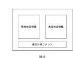
地図情報対応テーブルにおける記憶項目は、「地図情報ID」「地図情報名」「作成日」「作成者ID」「関連分析データ」「高度地図情報アドレス」「高度分析コメント」等となっており、それらの項目に情報が記載されている。 The storage items in the map information correspondence table are “map information ID”, “map information name”, “creation date”, “creator ID”, “related analysis data”, “advanced map information address”, “advanced analysis comment”, etc. Information is described in those items.
地図情報IDとは、高度地図情報及び関連する情報を管理するための識別子(ID)であり、制御部13が付与するものである。
地図情報名は、クライアント5を操作するユーザが任意に決定して付与するものである。
作成日は、当該地図情報対応テーブルを作成した日のデータであり、作成日時のデータであってもよい。このデータも制御部13が付与するものである。
作成者IDとは、当該地図情報対応テーブルを作成したユーザの識別子(ID)である。ユーザIDは、クライアント5に対応して制御部13が管理しており、制御部13が付与するものである。
The map information ID is an identifier (ID) for managing altitude map information and related information, and is given by the
The map information name is arbitrarily determined and given by the user operating the
The creation date is data of a date when the map information correspondence table is created, and may be data of creation date. This data is also given by the
The creator ID is an identifier (ID) of the user who created the map information correspondence table. The user ID is managed by the
関連分析データとは、GIS分析を行う際に用いられた分析対象のデータの内、キーとなるデータである。具体的には、分析対象の店舗のデータ、顧客のデータ、期間のデータ等が含まれ、当該期間の店舗の売上、顧客の購入に関する具体的データは店舗DB・顧客DB4に格納することとし、地図情報対応テーブルには記憶しないようにしておく。
この関連分析データが、GIS Webサーバ1で作成された簡易地図情報に関連する高度地図情報を容易に検索可能とするものである。
The related analysis data is key data among the analysis target data used when performing the GIS analysis. Specifically, the analysis target store data, customer data, period data, and the like are included, and specific data related to store sales and customer purchases in the period are stored in the store DB /
This related analysis data makes it possible to easily search for advanced map information related to the simple map information created by the
高度地図情報アドレスとは、高度地図情報データが格納されている格納先(アドレス)を示している。
高度分析コメントとは、高度地図情報が作成された際に行った高度分析に対してユーザが記述する項目である。この高度分析コメントには、販売戦略等の立案に関するコメントも含まれる。
The altitude map information address indicates a storage location (address) where altitude map information data is stored.
The advanced analysis comment is an item that the user describes for the advanced analysis performed when the advanced map information is created. This advanced analysis comment includes comments on planning of sales strategies and the like.
次に、本システムにおける動作を説明する。
まず、GIS Webサーバ1の機能を利用するユーザは、利用のための登録(初期登録)が必要である。この初期登録によって、ユーザには、ユーザIDとパスワードが定められ、ユーザIDとパスワードがGIS Webサーバ1のユーザデータベース(図示せず)に格納される。
Next, the operation in this system will be described.
First, a user who uses the function of the
そして、クライアント5,9からユーザがGIS Webサーバ1にアクセスする際には、当該ユーザIDとパスワードによってログインする。つまり、ログインの際に、ユーザはシステムからユーザIDとパスワードを要求され、その要求に応じて入力されたユーザIDとパスワードが真正であれば、ログインが許可されるものである。
When the user accesses the
クライアント5のユーザは、GISパッケージアプリケーションの高度GIS機能により顧客管理システム6を動作させて顧客データ、店舗データ、POSデータに関する分析(高度分析)を行う。
クライアント5のユーザは、GIS Webサーバ1にログインし、ログインが許可されると、高度分析結果をGIS Webサーバ1にアップロードする。
The user of the
The user of the
すると、GIS Webサーバ1の地図情報作成・表示手段13aは、統計DB2の統計データ又はクライアント5からアップロードされた統計データ、地図情報DB3の地図の画像データを用いて高度分析結果に基づく高度地図情報を作成してクライアント5に表示出力する。高度地図情報の作成に、統計DB2の統計データを必要としない場合は、高度分析結果と地図情報DB3の地図の画像データで高度地図情報を作成することになる。
そして、GIS Webサーバ1の地図情報記憶制御手段13bは、地図情報対応テーブルを作成し、地図情報ID等のデータを入力し、作成した高度地図情報を地図情報DB3に格納すると共にその格納アドレスを地図情報対応テーブルに記憶する。
Then, the map information creation / display unit 13a of the
Then, the map information storage control means 13b of the
そして、クライアント9は、GIS Webサーバ1にログインし、ログインが許可されると、ユーザが特定したデータについて、GIS Webサーバ1の制御部13における簡易GIS分析手段13cを用いて簡易GIS機能により分析(簡易分析)を行い、その簡易分析結果に基づいて地図情報作成・表示手段13aが簡易地図情報を作成してクライアント9の表示部に表示出力する。
Then, the
更に、GIS Webサーバ1は、簡易地図情報の表示に際して、簡易分析のデータに関連する分析データで高度分析が為されている場合には、図4に示すように、「関連情報有り」の表示及び関連情報についての更新情報を表示する。図4は、本発明の実施の形態に係るクライアント9での表示例を示す説明図である。
そして、クライアント9で「関連情報有り」がクリックされると、図5に示すように、GIS Webサーバ1は、地図情報対応テーブルを参照して高度地図情報をクライアント9に表示出力する。図5は、本発明の実施の形態に係るクライアント9での表示例を示す説明図である。
更に、その高度地図情報に関連して高度分析コメントがあれば、GIS Webサーバ1は、高度分析コメントも表示出力する。
Further, when displaying the simple map information, the
When “relevant information exists” is clicked on the
Furthermore, if there is an altitude analysis comment related to the altitude map information, the
尚、クライアント9からも高度情報地図を閲覧した場合は、その内容についてコメントを送信できる。この場合、図3の地図情報対応テーブルにクライアント9からのコメントを格納するエリアを設けて当該コメントを格納し、他のクライアントからの高度地図情報の関連情報の閲覧が入力されると、地図情報対応テーブルに格納したクライアント9のコメントを表示する。
If the altitude information map is viewed from the
次に、上記における地図情報対応テーブルの作成処理及び高度地図情報の登録処理を説明する。
具体的には、クライアント5から高度分析結果がGIS Webサーバ1にアップロードされると、地図情報作成・表示手段13aは高度地図情報を作成し、クライアント5に表示出力し、地図情報記憶制御手段13bは、当該高度分析結果に基づく地図情報対応テーブルを作成し、地図情報ID、地図情報名、作成日、作成者ID、関連分析データ、高度地図情報アドレス、高度分析コメントの設定を行う。
Next, the map information correspondence table creation process and altitude map information registration process will be described.
Specifically, when the altitude analysis result is uploaded from the
地図情報記憶制御手段13bは、地図情報ID、作成日を自動的に地図情報対応テーブルに設定するものであり、作成者IDはクライアント5から取得して、地図情報名はクライアント5が特定したものを設定する。
また、関連分析データは、高度分析に用いられたキーとなるデータを地図情報記憶制御手段13cが選択して地図情報対応テーブルに設定する。
The map information storage control means 13b automatically sets the map information ID and creation date in the map information correspondence table, the creator ID is obtained from the
Further, as the related analysis data, the map information storage control means 13c selects the data used as the key used for the advanced analysis and sets it in the map information correspondence table.
高度分析コメントは、クライアント5から高度分析結果に対応するものがアップロードされれば、地図情報記憶制御手段13bは、そのコメント内容を地図情報対応テーブルに設定する。
また、高度地図情報が作成され、地図情報DB3に格納されると、地図情報記憶制御手段13bは、その高度地図情報の格納アドレスを地図情報対応テーブルに設定する。
このようにして、地図情報対応テーブルの作成処理及び高度地図情報の登録処理が為される。
If an altitude analysis comment corresponding to the altitude analysis result is uploaded from the
When the altitude map information is created and stored in the
In this way, the map information correspondence table creation process and the altitude map information registration process are performed.
例えば、広域に店舗展開する小売業(スーパーマーケット等)について考えると、スーパーマーケットの本部がクライアント5を用いて高度分析を行い、その高度分析結果に基づく高度地図情報をGIS Webサーバ1にアップロードし、特定エリアのスーパーマーケットの店長がクライアント9を用いてGIS Webサーバ1に簡易分析を行わせ、高度分析に基づく高度地図情報がGIS Webサーバ1にアップロードされていれば、高度地図情報も閲覧可能となり、クライアント5から高度分析コメントがアップロードされていれば、高度分析コメントも閲覧でき、そのエリアにおける販売戦略等の立案を容易に行うことができるものである。
尚、これら地図情報を特定期間保存することにより、特定期間における分析結果、比較結果が閲覧可能となり、長期的な販売戦略等の立案を容易に行うことができる。
For example, when considering a retail business (such as a supermarket) that develops stores in a wide area, the headquarters of the supermarket performs an advanced analysis using the
By storing these map information for a specific period, analysis results and comparison results in the specific period can be browsed, and a long-term sales strategy can be easily planned.
また、本システムにおいて、POS DB8と連動させ、クライアント5が顧客管理システム6を介してPOS DB8におけるPOSデータの集計結果を利用可能とすることで、簡易分析による簡易地図情報、高度分析による高度地図情報、高度分析コメントを閲覧可能とすることができ、簡易分析の簡易地図情報に対して売上等の実績に対応した高度分析の高度地図情報を表示でき、その実績に基づく高度分析コメントも提供できる。
In addition, in this system, the
本システムによれば、GIS Webサーバ1の簡易GIS機能によって簡易分析を行って簡易地図情報を作成し、クライアント5の高度GIS機能によって高度分析を行って高度地図情報を作成し、高度地図情報を地図情報対応テーブルで管理し、高度分析コメントも対応付けて記憶するようにしているので、簡易地図情報と高度地図情報、高度分析コメントも参照でき、効率的な販売戦略等の立案を行うことができる効果がある。
According to this system, simple map information is created by performing a simple analysis by the simple GIS function of the
本システムによれば、クライアント5を本店に配置し、クライアント9を支店に配置することで、顧客データ及び店舗の売上等のデータを共有でき、クライアント5では、高度分析結果に基づく、例えば、店舗のクラス分け、顧客のカテゴリ分け、分析データの更新等を行い、クライアント9では、上記分析結果及び更新データを閲覧できる。
尚、クライアント9でも店舗又は顧客の属性を訂正する更新が可能である。
According to this system, by arranging the
The
本システムによれば、クライアント5では、高度分析のシミュレーションを行うことができ、ハフモデル分析、デシル分析、RFM分析、売上予測、相関分析、重回帰分析等の高度分析結果をGIS Webサーバ1にアップロードできるので、クライアント9では、高度分析されていれば、それら分析結果を閲覧でき、また、分布地図を色分け表示して、対象地域の顧客リストを出力する等の簡易分析を実現できるものである。
According to this system, the
本システムによれば、クライアント5が高度分析結果をGIS Webサーバ1にアップロードするので、クライアント9では、簡易分析結果から高度分析結果に基づく高度地図情報を表示出力するので、分析結果の共有を容易に行うことができる。
According to this system, since the
また、本システムでは、クライアント9から高度分析結果に対して、期間を限定したり、数値を限定したりする条件入力を可能としているので、クライアント5で為された高度分析結果に対して当該条件に基づき限定的な分析結果を得ることができ、クライアント9として必要な分析結果に基づく高度地図情報を閲覧できる効果がある。
In the present system, the
本発明は、簡易な分析を行い、更に、パッケージソフトのGIS機能を用いて高度分析が為されていれば、その高度分析結果を関連情報としてウェブ上で提供し、両方の分析結果を比較可能とした地図情報システムに適している。 The present invention performs simple analysis, and if advanced analysis is performed using the GIS function of the package software, the advanced analysis results are provided on the web as related information, and both analysis results can be compared. Suitable for the map information system.
1…GIS Webサーバ、 2…統計DB、 3…地図情報DB、 4…クライアント、 11…入力部、 12…出力部、 13…制御部、 13a…地図情報作成・表示手段、 13b…地図情報記憶制御手段、 13c…簡易GIS分析手段
DESCRIPTION OF
Claims (7)
地図の画像データ、作成された地図情報を格納する地図情報データベースと、
店舗情報を格納する店舗データベースと、
顧客情報を格納する顧客データベースと、
統計データ、顧客情報又は/及び売上情報に基づいて高度分析を行い、高度分析結果及び分析に用いた分析データをアップロードする高度クライアントと、
簡易分析を依頼し、当該簡易分析結果に基づく簡易地図情報の表示が為される簡易クライアントと、
前記高度クライアントからアップロードされた高度分析結果に基づいて前記地図情報データベースの地図の画像データを用いて高度地図情報を作成し、当該高度地図情報を前記地図情報データベースに格納すると共に、前記アップロードされた分析データとなる統計データ、店舗データ、顧客データを対応する前記統計データベース、前記店舗データベース、前記顧客データベースに格納し、前記高度地図情報の格納先と高度分析に用いられた分析データとを地図情報対応テーブルに設定し、簡易分析機能を備えて簡易分析を行い、当該簡易分析結果に基づいて前記地図情報データベースの地図の画像データを用いて簡易地図情報を作成し、当該簡易分析に用いられた分析データから前記地図情報対応テーブルを参照して該当する分析データがあれば、当該分析データに対応する高度地図情報の格納先を読み取って前記高度地図情報を前記簡易クライアントに表示出力するサーバとを有することを特徴とする地図情報システム。 A statistical database for storing statistical data;
A map information database for storing map image data and created map information;
A store database that stores store information;
A customer database that stores customer information;
An advanced client that performs advanced analysis based on statistical data, customer information or / and sales information, and uploads the results of the advanced analysis and analysis data used in the analysis;
A simple client that requests a simple analysis and displays simple map information based on the simple analysis result,
Based on the altitude analysis result uploaded from the altitude client, the altitude map information is created using the map image data of the map information database, the altitude map information is stored in the map information database, and the uploaded Statistical data that is analysis data, store data, customer data is stored in the corresponding statistical database, the store database, and the customer database, and the storage location of the advanced map information and the analysis data used for the advanced analysis are mapped to the map information Set in the correspondence table, perform simple analysis with a simple analysis function, create simple map information using map image data of the map information database based on the simple analysis result, and used for the simple analysis The corresponding analysis data by referring to the map information correspondence table from the analysis data If any, map information system, comprising a server which reads the storage location of the altitude map information corresponding to the analyzed data to display outputs the altitude map information to the simple client.
サーバは、前記高度クライアントからアップロードされた高度分析コメントを地図情報対応テーブルにおける高度地図情報の格納先に対応付けて格納し、簡易クライアントに高度地図情報を表示出力する際に、前記高度分析コメントも表示出力することを特徴とする請求項1記載の地図情報システム。 The advanced client uploads advanced analysis comments accompanying advanced analysis to the server,
The server stores the altitude analysis comment uploaded from the altitude client in association with the storage location of the altitude map information in the map information correspondence table, and when the altitude map information is displayed and output to the simple client, the altitude analysis comment is also stored. 2. The map information system according to claim 1, wherein the map information system is displayed and output.
サーバは、前記簡易クライアントから設定された条件に従って高度地図情報を作成し、前記簡易クライアントに作成した高度地図情報を表示出力することを特徴とする請求項1又は2記載の地図情報システム。 The simple client sets conditions for the results of advanced analysis,
3. The map information system according to claim 1, wherein the server creates altitude map information in accordance with conditions set by the simple client, and displays and outputs the altitude map information created on the simple client.
簡易クライアントから簡易分析を依頼されると、当該依頼に基づいて簡易分析を行う簡易分析手段と、
前記簡易分析手段における簡易分析結果又は高度クライアントからアップロードされた高度分析結果に基づき統計データベースの統計データ又は/及び地図情報データベースの地図の画像データを用いて簡易地図情報又は高度地図情報を作成して前記簡易クライアント又は前記高度クライアントに表示出力する地図情報作成・表示手段と、
前記アップロードされた高度分析結果となる統計データ、店舗データ又は/及び顧客データを対応する前記統計データベース、前記店舗データベース、前記顧客データベースに格納し、前記作成された高度地図情報を前記地図情報データベースに格納すると共に、前記高度地図情報の格納先と当該高度分析結果に用いられた分析データとを地図情報対応テーブルに設定する地図情報記憶制御手段とを有し、
前記地図情報作成・表示手段は、前記簡易分析に用いられたデータから前記地図情報対応テーブルを参照して該当する分析データがあれば、当該分析データに対応する高度地図情報の格納先を読み取って前記高度地図情報を前記簡易クライアントに表示出力するものであることを特徴とする地図情報システム。 The server
When a simple client requests a simple analysis, a simple analysis means for performing a simple analysis based on the request,
Simple map information or advanced map information is created using statistical data of a statistical database or / and map image data of a map information database based on a simple analysis result in the simple analysis means or an advanced analysis result uploaded from an advanced client. Map information creation / display means for display output on the simple client or the altitude client;
The uploaded statistical data, the store data or / and the customer data are stored in the corresponding statistical database, the store database, and the customer database, and the created advanced map information is stored in the map information database. And storing map information storage control means for setting the storage location of the altitude map information and the analysis data used for the altitude analysis result in a map information correspondence table,
The map information creating / displaying unit reads the storage location of the advanced map information corresponding to the analysis data if there is corresponding analysis data referring to the map information correspondence table from the data used for the simple analysis. A map information system, wherein the altitude map information is displayed and output to the simple client.
高度クライアントからアップロードされた高度分析コメントを地図情報対応テーブルにおける高度地図情報の格納先に対応付けて格納し、簡易クライアントに高度地図情報を表示出力する際に、前記高度分析コメントも表示出力するものであることを特徴とする請求項6記載の地図情報システム。 The map information storage control means in the server is
The altitude analysis comments uploaded from the altitude client are stored in association with the altitude map information storage location in the map information correspondence table, and when the altitude map information is displayed and output to the simple client, the altitude analysis comments are also displayed and output. The map information system according to claim 6, wherein the map information system is a map information system.
Priority Applications (1)
| Application Number | Priority Date | Filing Date | Title |
|---|---|---|---|
| JP2003339722A JP2005107103A (en) | 2003-09-30 | 2003-09-30 | Map information system |
Applications Claiming Priority (1)
| Application Number | Priority Date | Filing Date | Title |
|---|---|---|---|
| JP2003339722A JP2005107103A (en) | 2003-09-30 | 2003-09-30 | Map information system |
Publications (2)
| Publication Number | Publication Date |
|---|---|
| JP2005107103A true JP2005107103A (en) | 2005-04-21 |
| JP2005107103A5 JP2005107103A5 (en) | 2007-03-22 |
Family
ID=34534837
Family Applications (1)
| Application Number | Title | Priority Date | Filing Date |
|---|---|---|---|
| JP2003339722A Pending JP2005107103A (en) | 2003-09-30 | 2003-09-30 | Map information system |
Country Status (1)
| Country | Link |
|---|---|
| JP (1) | JP2005107103A (en) |
Cited By (5)
| Publication number | Priority date | Publication date | Assignee | Title |
|---|---|---|---|---|
| JP2010277567A (en) * | 2008-10-07 | 2010-12-09 | Giken Shoji International Co Ltd | Dm distribution area analysis device |
| CN102308309A (en) * | 2009-02-03 | 2012-01-04 | 瑟伦·朗厄 | Technologies for mapping a set of criteria |
| JP2013029883A (en) * | 2011-07-26 | 2013-02-07 | Giken Shoji International Co Ltd | Shop profiling system |
| KR101910107B1 (en) * | 2018-08-13 | 2018-10-19 | 주식회사 아발론교육 | Method and apparatus for displaying map and item |
| US20240061811A1 (en) * | 2015-05-18 | 2024-02-22 | Ice Data Pricing & Reference Data, Llc | Data conversion and distribution systems |
Citations (5)
| Publication number | Priority date | Publication date | Assignee | Title |
|---|---|---|---|---|
| JPH11353465A (en) * | 1998-06-10 | 1999-12-24 | Hitachi Ltd | Spatial information sharing device |
| JP2001216235A (en) * | 2000-02-03 | 2001-08-10 | Efgenex Corp | Distribution service method for map relating data |
| JP2001229186A (en) * | 2000-02-18 | 2001-08-24 | Dainippon Printing Co Ltd | Map composite information generation system |
| JP2002049307A (en) * | 2000-05-04 | 2002-02-15 | Cyber Map World Co Ltd | Method for providing geographical information and advertisement information by means of vector map using internet |
| JP2003150267A (en) * | 2001-11-16 | 2003-05-23 | Hitachi Software Eng Co Ltd | Method for providing service program |
-
2003
- 2003-09-30 JP JP2003339722A patent/JP2005107103A/en active Pending
Patent Citations (5)
| Publication number | Priority date | Publication date | Assignee | Title |
|---|---|---|---|---|
| JPH11353465A (en) * | 1998-06-10 | 1999-12-24 | Hitachi Ltd | Spatial information sharing device |
| JP2001216235A (en) * | 2000-02-03 | 2001-08-10 | Efgenex Corp | Distribution service method for map relating data |
| JP2001229186A (en) * | 2000-02-18 | 2001-08-24 | Dainippon Printing Co Ltd | Map composite information generation system |
| JP2002049307A (en) * | 2000-05-04 | 2002-02-15 | Cyber Map World Co Ltd | Method for providing geographical information and advertisement information by means of vector map using internet |
| JP2003150267A (en) * | 2001-11-16 | 2003-05-23 | Hitachi Software Eng Co Ltd | Method for providing service program |
Non-Patent Citations (1)
| Title |
|---|
| "「地図情報システム イントラネットGIS イントラネット上で地図情報を活用 精度の高いゾーンマネジメ", 日経情報ストラテジー, vol. 第7巻,第8号, JPN6008048700, 24 August 1998 (1998-08-24), JP, pages 252 - 253, ISSN: 0001141878 * |
Cited By (5)
| Publication number | Priority date | Publication date | Assignee | Title |
|---|---|---|---|---|
| JP2010277567A (en) * | 2008-10-07 | 2010-12-09 | Giken Shoji International Co Ltd | Dm distribution area analysis device |
| CN102308309A (en) * | 2009-02-03 | 2012-01-04 | 瑟伦·朗厄 | Technologies for mapping a set of criteria |
| JP2013029883A (en) * | 2011-07-26 | 2013-02-07 | Giken Shoji International Co Ltd | Shop profiling system |
| US20240061811A1 (en) * | 2015-05-18 | 2024-02-22 | Ice Data Pricing & Reference Data, Llc | Data conversion and distribution systems |
| KR101910107B1 (en) * | 2018-08-13 | 2018-10-19 | 주식회사 아발론교육 | Method and apparatus for displaying map and item |
Similar Documents
| Publication | Publication Date | Title |
|---|---|---|
| Taylor et al. | Internet marketing: web site navigational design issues | |
| US8719092B2 (en) | Method and system for directing information to a plurality of users | |
| US20210319493A1 (en) | Real-time recommendation monitoring dashboard | |
| GB2491251A (en) | Delivery of content and services to networked connected computing devices | |
| KR20190086245A (en) | Apparatus and method for providing advertisement using SNS, and computer program for executing the method | |
| AU2007347379A1 (en) | Method and apparatus for navigating a graphical representation of a virtual exhibition | |
| US8255279B2 (en) | Method and apparatus for permitting stage-door access to on-line vendor information | |
| US20020103658A1 (en) | Process for compiling and centralizing business data | |
| WO2002003243A1 (en) | Integration of third party sites into internet mall | |
| JP6218783B2 (en) | Mortgage pre-screening system, method and program | |
| Briand et al. | From global action against malaria to local issues: state of the art and perspectives of web platforms dealing with malaria information | |
| KR101829703B1 (en) | Method for Providing Sharing Service of Goods Information Searching | |
| Ramos et al. | Marketing intelligence and automation–An approach associated with tourism in order to obtain economic benefits for a region | |
| JP2005107103A (en) | Map information system | |
| JP2024000514A (en) | Method, information processing system, and program | |
| KR100771762B1 (en) | Service method for managing cashback card and providing information of affiliated shops by means of portable RF telecommunication terminal, and system therefor | |
| Duranceau | License tracking | |
| JP7326798B2 (en) | Product promotion device | |
| KR20020006905A (en) | System and method for providing search index information with real-time changing, a media for recording program source | |
| Daras et al. | Conceptual Framework for SDSS Development with an Application in the Retail Industry | |
| JP2009129066A (en) | Commodity distribution system | |
| KR20080008677A (en) | Open type internet shoppingmall system and method for operating the same | |
| Sreekanth et al. | GIS-based decision support system (DSS) for recommending retail outlet locations | |
| JP2004126747A (en) | Real-estate-related information system | |
| JP2002259416A (en) | Medium with information acquisition program recorded thereon, information transmission device, medium with preservation term management program recorded thereon, character information display structure, commodity retrieval device, charge for delivery calculation device, introduction device |
Legal Events
| Date | Code | Title | Description |
|---|---|---|---|
| A521 | Request for written amendment filed |
Free format text: JAPANESE INTERMEDIATE CODE: A523 Effective date: 20060928 |
|
| A621 | Written request for application examination |
Free format text: JAPANESE INTERMEDIATE CODE: A621 Effective date: 20060928 |
|
| A521 | Request for written amendment filed |
Free format text: JAPANESE INTERMEDIATE CODE: A523 Effective date: 20070131 |
|
| A977 | Report on retrieval |
Free format text: JAPANESE INTERMEDIATE CODE: A971007 Effective date: 20080630 |
|
| A131 | Notification of reasons for refusal |
Free format text: JAPANESE INTERMEDIATE CODE: A131 Effective date: 20080924 |
|
| A521 | Request for written amendment filed |
Free format text: JAPANESE INTERMEDIATE CODE: A523 Effective date: 20081114 |
|
| A131 | Notification of reasons for refusal |
Free format text: JAPANESE INTERMEDIATE CODE: A131 Effective date: 20090602 |
|
| A02 | Decision of refusal |
Free format text: JAPANESE INTERMEDIATE CODE: A02 Effective date: 20091014 |