EP4287157A1 - Method for determining or allocating lane information relating to a plurality of traffic participants on a route, telecommunication networks or system, traffic participants, computer program and computer readable medium - Google Patents
Method for determining or allocating lane information relating to a plurality of traffic participants on a route, telecommunication networks or system, traffic participants, computer program and computer readable medium Download PDFInfo
- Publication number
- EP4287157A1 EP4287157A1 EP22176477.2A EP22176477A EP4287157A1 EP 4287157 A1 EP4287157 A1 EP 4287157A1 EP 22176477 A EP22176477 A EP 22176477A EP 4287157 A1 EP4287157 A1 EP 4287157A1
- Authority
- EP
- European Patent Office
- Prior art keywords
- information
- road users
- road
- lane
- der
- Prior art date
- Legal status (The legal status is an assumption and is not a legal conclusion. Google has not performed a legal analysis and makes no representation as to the accuracy of the status listed.)
- Pending
Links
- 238000000034 method Methods 0.000 title claims abstract description 76
- 238000004590 computer program Methods 0.000 title claims description 17
- 230000002776 aggregation Effects 0.000 claims description 13
- 238000004220 aggregation Methods 0.000 claims description 13
- 238000004364 calculation method Methods 0.000 claims description 8
- 238000001514 detection method Methods 0.000 abstract description 8
- 238000012937 correction Methods 0.000 description 17
- 241001136792 Alle Species 0.000 description 16
- 238000004891 communication Methods 0.000 description 15
- 230000008569 process Effects 0.000 description 12
- 238000005259 measurement Methods 0.000 description 11
- 239000000243 solution Substances 0.000 description 9
- 238000013480 data collection Methods 0.000 description 7
- 238000011156 evaluation Methods 0.000 description 5
- 238000012360 testing method Methods 0.000 description 5
- 230000005540 biological transmission Effects 0.000 description 4
- 238000012545 processing Methods 0.000 description 4
- 210000002023 somite Anatomy 0.000 description 4
- 238000004422 calculation algorithm Methods 0.000 description 3
- 230000004807 localization Effects 0.000 description 3
- 206010000369 Accident Diseases 0.000 description 2
- 230000001133 acceleration Effects 0.000 description 2
- 230000001413 cellular effect Effects 0.000 description 2
- 238000009795 derivation Methods 0.000 description 2
- 230000000694 effects Effects 0.000 description 2
- 230000006872 improvement Effects 0.000 description 2
- 238000009434 installation Methods 0.000 description 2
- 238000012805 post-processing Methods 0.000 description 2
- 230000006978 adaptation Effects 0.000 description 1
- 239000000654 additive Substances 0.000 description 1
- 230000000996 additive effect Effects 0.000 description 1
- 238000004140 cleaning Methods 0.000 description 1
- 238000010276 construction Methods 0.000 description 1
- 230000001419 dependent effect Effects 0.000 description 1
- 230000004069 differentiation Effects 0.000 description 1
- 230000008030 elimination Effects 0.000 description 1
- 238000003379 elimination reaction Methods 0.000 description 1
- 238000005516 engineering process Methods 0.000 description 1
- 238000007667 floating Methods 0.000 description 1
- 238000000691 measurement method Methods 0.000 description 1
- 238000010295 mobile communication Methods 0.000 description 1
- 230000000737 periodic effect Effects 0.000 description 1
- 238000009420 retrofitting Methods 0.000 description 1
- 238000012546 transfer Methods 0.000 description 1
- 230000001960 triggered effect Effects 0.000 description 1
Images
Classifications
-
- G—PHYSICS
- G08—SIGNALLING
- G08G—TRAFFIC CONTROL SYSTEMS
- G08G1/00—Traffic control systems for road vehicles
- G08G1/01—Detecting movement of traffic to be counted or controlled
- G08G1/0104—Measuring and analyzing of parameters relative to traffic conditions
- G08G1/0108—Measuring and analyzing of parameters relative to traffic conditions based on the source of data
- G08G1/0112—Measuring and analyzing of parameters relative to traffic conditions based on the source of data from the vehicle, e.g. floating car data [FCD]
-
- G—PHYSICS
- G08—SIGNALLING
- G08G—TRAFFIC CONTROL SYSTEMS
- G08G1/00—Traffic control systems for road vehicles
- G08G1/01—Detecting movement of traffic to be counted or controlled
- G08G1/0104—Measuring and analyzing of parameters relative to traffic conditions
- G08G1/0108—Measuring and analyzing of parameters relative to traffic conditions based on the source of data
- G08G1/0116—Measuring and analyzing of parameters relative to traffic conditions based on the source of data from roadside infrastructure, e.g. beacons
-
- G—PHYSICS
- G08—SIGNALLING
- G08G—TRAFFIC CONTROL SYSTEMS
- G08G1/00—Traffic control systems for road vehicles
- G08G1/01—Detecting movement of traffic to be counted or controlled
- G08G1/0104—Measuring and analyzing of parameters relative to traffic conditions
- G08G1/0125—Traffic data processing
- G08G1/0133—Traffic data processing for classifying traffic situation
-
- G—PHYSICS
- G08—SIGNALLING
- G08G—TRAFFIC CONTROL SYSTEMS
- G08G1/00—Traffic control systems for road vehicles
- G08G1/16—Anti-collision systems
- G08G1/167—Driving aids for lane monitoring, lane changing, e.g. blind spot detection
-
- H—ELECTRICITY
- H04—ELECTRIC COMMUNICATION TECHNIQUE
- H04W—WIRELESS COMMUNICATION NETWORKS
- H04W4/00—Services specially adapted for wireless communication networks; Facilities therefor
- H04W4/02—Services making use of location information
- H04W4/021—Services related to particular areas, e.g. point of interest [POI] services, venue services or geofences
-
- H—ELECTRICITY
- H04—ELECTRIC COMMUNICATION TECHNIQUE
- H04W—WIRELESS COMMUNICATION NETWORKS
- H04W4/00—Services specially adapted for wireless communication networks; Facilities therefor
- H04W4/30—Services specially adapted for particular environments, situations or purposes
- H04W4/40—Services specially adapted for particular environments, situations or purposes for vehicles, e.g. vehicle-to-pedestrians [V2P]
- H04W4/44—Services specially adapted for particular environments, situations or purposes for vehicles, e.g. vehicle-to-pedestrians [V2P] for communication between vehicles and infrastructures, e.g. vehicle-to-cloud [V2C] or vehicle-to-home [V2H]
-
- H—ELECTRICITY
- H04—ELECTRIC COMMUNICATION TECHNIQUE
- H04W—WIRELESS COMMUNICATION NETWORKS
- H04W88/00—Devices specially adapted for wireless communication networks, e.g. terminals, base stations or access point devices
- H04W88/02—Terminal devices
- H04W88/04—Terminal devices adapted for relaying to or from another terminal or user
Definitions
- the invention relates to a method for determining or assigning lane information regarding several road users located on a route section.
- the invention further relates to a telecommunications network or a system for determining or assigning lane information regarding several road users located on a route section.
- the invention further relates to a road user for use in a telecommunications network according to the invention or in a system according to the invention.
- the invention further relates to a computer program comprising instructions with which the steps of a method according to the invention can be carried out, and a computer-readable medium, intended for storing a computer program, or a data carrier signal, intended for transmitting a computer program, wherein the computer-readable medium or the data carrier signal Computer program according to the invention stores or transmits.
- C-V2X cellular V2X communication
- the invention is based on the object of providing a method or a method for determining or assigning lane information regarding several road users located on a route section, in particular for possibly different routes in a traffic system, which in a traffic system (e.g. Intelligent Transport System (ITS)) with V2X communication is cost-effective, precise (at the time of calculation), current and anonymous, and only collects data via V2X broadcast messages.
- a traffic system e.g. Intelligent Transport System (ITS)
- ITS Intelligent Transport System
- the determination or assignment of lane information regarding several road users located on a route section (or the determination of an estimated value or a predicted value for this) to be more precise or with a higher precision or Prediction accuracy is possible, while at the same time the effort required to implement or provide such a system is comparatively low.
- lane information regarding several road users located on a section of route the existing number of lanes for a section of route under consideration is first determined or retrieved from a database; A respective lane information is then determined or assigned to each of the road users.
- lane detection Methods of lane detection (or hereinafter referred to as lane detection for short) are already available from the prior art, but these methods usually use vehicle-to-vehicle measurements or vehicle-to-lane measurements with electro-optical methods or they use highly accurate GNSS localization methods together with highly accurately measured road lanes. There are also methods that can use ground-based sensors such as radar or digital cameras to determine the position of FZGen on a road with high precision in a locally very limited area. Track determinations can even be carried out using remote sensing methods from satellites. All of these well-known methods always require a lot (e.g.
- ground-based sensors such as digital cameras are used according to known methods in order to be able to determine the number of vehicle traffic per unit of time on a road cross section (the traffic volume).
- FCD method Floating Car Data
- the lane of a vehicle on a multi-lane road is not determined; Further disadvantages include, in particular, the need to use expensive equipment for comprehensive, seamless earth-based installation, as well as privacy violations. Should the lane determination even be used to improve lane and possibly also vehicle type-specific traffic information (e.g. to predict driving times on a road section), it must be possible to determine the lane for as many vehicles as possible on a longer route without any gaps and at the same time; Airborne methods (based on aircraft or satellites) are usually too expensive; the same applies to ground-based sensors. According to the invention, an FZG-related measurement method is specified, which can be implemented comparatively inexpensively and (due to a comparatively low retrofitting effort) can be used by all FZGen on the longer section of the route.
- a respective provisional lane information is determined or assigned to each of the road users, with a second sub-step of the second step checking whether the provisional lane information needs to be adapted or corrected is, whereby, if the provisional lane information is to be corrected, in a third sub-step of the second step, corrected lane information is determined or assigned for at least some of the road users on the basis of the provisional lane information, wherein in a fourth sub-step of the second step, the corrected lane information is determined as the lane information is assigned to the respective road user.
- the second sub-step and the third sub-step are carried out repeatedly, in particular iteratively, checking whether the corrected lane information needs to be corrected again and, if so , further corrected lane information is determined or assigned for at least some of the road users.
- the geographical area includes the route section, wherein the route section corresponds in particular to a route section of a traffic route, in particular a road, such as an expressway or motorway, or the geographical area defines the corresponding area of the route section , wherein in particular the area information includes directional information and/or wherein the area information includes position information of the stationary receiver.
- the road user under consideration only sends the at least one further broadcast message when the current or most recently determined position of the road user under consideration is recognized by position determination means of the road user under consideration as being within the geographical area or if the road user under consideration is recognized by the position determination means as being on the section of the traffic route and/or is recognized as moving on the section of the traffic route in the direction of or in accordance with the directional information.
- the task is further solved by a road user who acts in particular as a communication participant, ie in particular as a transmitter or receiver, for use in a telecommunications network or system according to the invention.
- the output is solved by a computer program comprising commands with the help of which the steps of a method according to the invention can be carried out if the computer program is executed on a programmable device, in particular on a network node in the form of a transmitter and/or receiver and/or a road user becomes.
- the object is achieved by a computer-readable medium, intended for storing a computer program, or data carrier signal, intended for transmitting a computer program, wherein the computer-readable medium or the data carrier signal stores or transmits the computer program according to the invention or wherein the computer-readable medium or the data carrier signal on a programmable device, in particular on a network node in the form of a transmitter and / or receiver and / or a road user, stores or transmits part of the computer program according to the invention to be executed.
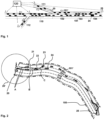
- Figure 1 shows a schematic situation of a plurality of road users, with position information of the current position of the road users and speed information of the road users being recorded on a route section 101 to determine the expected travel time or travel duration of the road users.
- Figure 2 Schematically individually designated road users 21, 22, 23, 24 is only one road user 24 in Figure 1 specifically designated.
- route section 101 is in Figure 2 further shown schematically how this is divided into a plurality of subsections, with between the transmitter 20 and the receiver 25 of the route section 101 or the geographical area 100 in Figure 1 a first subsection 102, a second subsection 103 and a third subsection 104 are shown, the first, second and third subsections 102, 103, 104 according to the exemplary illustration in Figure 1 are shown as arranged in a sequence against the direction of travel 101 'of road users on the section of route under consideration.
- FIG. 1 Further route sections 110, 111, 112 are shown, which lie or are arranged behind the currently traveled route section 101 in the direction of travel (and from the perspective of the road user 24).
- each of the road users 21, 22, 23, 24 is determined or assigned a respective provisional lane information
- in a second sub-step in the second step it is checked whether the provisional lane information needs to be adjusted or corrected, whereby, if the provisional lane information needs to be corrected, in a third sub-step of the second step, corrected lane information is provided for at least some of the road users 21 on the basis of the provisional lane information, 22, 23, 24 is determined or assigned, wherein in a fourth sub-step of the second step the corrected lane information is assigned as the lane information to the respective road user 21, 22, 23, 24.
- the second sub-step and the third sub-step are carried out repeatedly, in particular iteratively, checking whether the corrected lane information needs to be corrected again and, if so, further corrected lane information is determined or assigned for at least some of the road users 21, 22, 23, 24.
- the first and second steps for determining or assigning lane information are carried out either by the road user 21, 22, 23, 24 itself (or by a calculation device thereof) or by a device external to the road user 21, 22 , 23, 24 existing facility is carried out.
- the transmitter 20 as an authorized transmitter (eg at the radio mast of a network operator and at the starting point of the geographical area, for example a road section), periodically sends out an initial special broadcast message, the message content of the transmitter 20 to a plurality of receivers (road users 21, 22, 23, 24) as a broadcast message using a D2D functionality, device-to-device functionality or a PC5 sidelink functionality, in particular using Mode 4 functionality, is sent.
- the message is only enriched by vehicles (road users or receiving devices) on the road section of the geographical area 100 (defined in the initial broadcast message) and with the specified direction of travel 101 'with their own information (in particular position, speed, time stamp and vehicle type).
- a broadcast message (which can also be enriched by future recipients), whereby there can be (and usually will be) several chains of broadcast messages that are sent by the receiver 25 (or by the final receiver) when the end point of the road section is reached.
- a special receiving unit on the radio mast of a network operator are received and then processed into current traffic flow information for the road section.
- Each such chain of broadcast messages (which 'run' over or through the geographical area 100 to the receiver 25) is thus triggered or started by an initial special broadcast message, such initial special broadcast message being sent by the transmitter 20 according to the invention, in particular periodically (for example every 100, 200, 300, 400, 500, 600, 700 or 800 seconds or also every 2, 3, 4, 5, 8, 10, 12, 15, 18, 20, 25 or 30 minutes) are repeated (in particular using different, for example incremented, message identification information).
- the method combines a traffic system infrastructure with the definition of routes (sections) in a manner optimized for the method (and a dynamic adjustment), a V2X communication (according to 3GPP or ETSI standards) and a Data collection, data aggregation and data processing, especially with the use of broadcast waves.
- a vehicle wants to enter the route section, it receives a message wave with frequency f for this route section. If the FZG enters a route network, it can query the currently valid (most recently carried out) complete message wave for each of the route sections to be traveled from the V-Info system or a stationary transmitter (near) the entry point will receive the V-Info to all "coming" vehicles, e.g. via broadcast message, with a sufficiently high frequency.
- a truck that will/must drive in the right lane can potentially be predicted to have speeds that are too high. It is therefore the case that in conventionally known systems, in particular due to insufficiently good (or often completely missing) determination of a lane on a multi-lane road, the previously collected and further processed traffic information does not provide what is suggested by the information, namely the one suitable ( best possible) information for individual Road users.
Abstract
Es wird ein Verfahren zur Ermittlung oder zur Zuordnung einer Fahrspurinformation bezüglich mehrerer sich auf einem Streckenabschnitt befindender Verkehrsteilnehmer, wobei zur Ermittlung oder zur Zuordnung der Fahrspurinformation bezüglich der Verkehrsteilnehmer die Erfassung-- einer Positionsinformation der momentanen Position der Verkehrsteilnehmer,-- einer Geschwindigkeitsinformation der Verkehrsteilnehmerund-- einer Fahrzeugtypinformation und/oder einer Fahrzeugkategorieinformation erfolgt,wobei zur Ermittlung oder zur Zuordnung der Fahrspurinformation für die mehreren Verkehrsteilnehmer die nachfolgenden Schritte ausgeführt werden:-- in einem ersten Schritt wird zu einem betrachteten Streckenabschnitt die vorhandene Anzahl an Fahrspuren ermittelt oder von einer Datenbank abgerufen,-- in einem nachfolgenden zweiten Schritt wird jedem der Verkehrsteilnehmer eine jeweilige Fahrspurinformation ermittelt oder zugeordnet.There is a method for determining or assigning lane information regarding several road users located on a section of the route, whereby to determine or assign the lane information regarding the road users, the detection of - position information of the current position of the road users, - speed information of the road users and - - a vehicle type information and / or a vehicle category information takes place, the following steps being carried out to determine or assign the lane information for the several road users:-- in a first step, the existing number of lanes for a section of the route under consideration is determined or retrieved from a database ,-- In a subsequent second step, each of the road users is determined or assigned a respective lane information.
Description
Die Erfindung betrifft ein Verfahren zur Ermittlung oder zur Zuordnung einer Fahrspurinformation bezüglich mehrerer sich auf einem Streckenabschnitt befindender Verkehrsteilnehmer.The invention relates to a method for determining or assigning lane information regarding several road users located on a route section.
Die Erfindung betrifft des Weiteren ein Telekommunikationsnetz oder ein System zur Ermittlung oder zur Zuordnung einer Fahrspurinformation bezüglich mehrerer sich auf einem Streckenabschnitt befindender Verkehrsteilnehmer.The invention further relates to a telecommunications network or a system for determining or assigning lane information regarding several road users located on a route section.
Die Erfindung betrifft ferner einen Verkehrsteilnehmer zur Verwendung in einem erfindungsgemäßen Telekommunikationsnetz oder in einem erfindungsgemäßen System.The invention further relates to a road user for use in a telecommunications network according to the invention or in a system according to the invention.
Des Weiteren betrifft die Erfindung ein Computerprogramm umfassend Befehle, mit deren Hilfe die Schritte eines erfindungsgemäßen Verfahrens durchführbar sind, und ein computerlesbares Medium, vorgesehen zur Speicherung eines Computerprogramms, oder ein Datenträgersignal, vorgesehen zur Übertragung eines Computerprogramms, wobei das computerlesbare Medium oder das Datenträgersignal das erfindungsgemäße Computerprogramm speichert oder überträgt.The invention further relates to a computer program comprising instructions with which the steps of a method according to the invention can be carried out, and a computer-readable medium, intended for storing a computer program, or a data carrier signal, intended for transmitting a computer program, wherein the computer-readable medium or the data carrier signal Computer program according to the invention stores or transmits.
Bei vorbekannten Telekommunikationsnetzen ist es bereits bekannt, eine Gerät-zu-Gerät-Kommunikation (device-to-device communication) zu verwenden. Dies ist auch der Fall bei der zellularen V2X-Kmmunikation (C-V2X), welche die Möglichkeit zur Verfügung stellt, dass Kommunikationsteilnehmer bzw. Verkehrsteilnehmer Nachrichten authentisch bzw. autorisiert, anonym, sowie direkt (d.h. ohne Einbindung des Mobilfunknetzes, insbesondere über die PC5 Sidelink Funktionalität) in einer begrenzten Umgebung austauschen, insbesondere um Hauptanwendungsfälle wie Verkehrssicherheit, Verkehrsmanagement und Infotainment umsetzen zu können.In previously known telecommunications networks, it is already known to use device-to-device communication. This is also the case with cellular V2X communication (C-V2X), which makes it possible for communication participants or road users to receive messages authentically or authorized, anonymously, and directly (i.e. without involving the mobile network, especially via the PC5 Sidelink functionality) in a limited environment, in particular to be able to implement main use cases such as traffic safety, traffic management and infotainment.
Bei vorbekannten Verfahren zur Ermittlung oder zur Zuordnung einer Fahrspurinformation bezüglich mehrerer sich auf einem Streckenabschnitt befindender Verkehrsteilnehmer sind Probleme zu lösen, die sich beziehen beispielsweise auf die Aktualität und Genauigkeit der Daten oder Ergebnisse sowie die Kosten des Verfahrens bzgl. des Aufbaus einer Infrastruktur.In previously known methods for determining or assigning lane information regarding several road users on a route, problems must be solved that relate, for example, to: Currentness and accuracy of the data or results as well as the costs of the process in terms of setting up an infrastructure.
Der Erfindung liegt die Aufgabe zugrunde, ein Verfahren bzw. eine Methode zur Ermittlung oder zur Zuordnung einer Fahrspurinformation bezüglich mehrerer sich auf einem Streckenabschnitt befindender Verkehrsteilnehmer bereitzustellen, insbesondere für ggf. verschiedene Strecken in einem Verkehrssystem, welches in einem Verkehrssystem (z.B. Intelligent Transport System (ITS)) mit V2X-Kommunikation kostengünstig, präzise (zum Zeitpunkt der Berechnung), aktuell und anonym ist, sowie mit Datenerhebung rein über V2X-Broadcast-Nachrichten auskommt.The invention is based on the object of providing a method or a method for determining or assigning lane information regarding several road users located on a route section, in particular for possibly different routes in a traffic system, which in a traffic system (e.g. Intelligent Transport System ( ITS)) with V2X communication is cost-effective, precise (at the time of calculation), current and anonymous, and only collects data via V2X broadcast messages.
Die Aufgabe wird erfindungsgemäß gelöst durch ein Verfahren zur Ermittlung oder zur Zuordnung einer Fahrspurinformation bezüglich mehrerer sich auf einem Streckenabschnitt befindender Verkehrsteilnehmer, wobei zur Ermittlung oder zur Zuordnung der Fahrspurinformation bezüglich der Verkehrsteilnehmer die Erfassung
- -- einer Positionsinformation der momentanen Position der Verkehrsteilnehmer,
- -- einer Geschwindigkeitsinformation der Verkehrsteilnehmer
und - -- einer Fahrzeugtypinformation und/oder einer Fahrzeugkategorieinformation erfolgt,
- -- in einem ersten Schritt wird zu einem betrachteten Streckenabschnitt die vorhandene Anzahl an Fahrspuren ermittelt oder von einer Datenbank abgerufen,
- -- in einem nachfolgenden zweiten Schritt wird jedem der Verkehrsteilnehmer eine jeweilige Fahrspurinformation ermittelt oder zugeordnet.
- -- position information about the current position of the road users,
- -- speed information for road users
and - -- vehicle type information and/or vehicle category information is provided,
- -- in a first step, the existing number of lanes for a section of the route under consideration is determined or retrieved from a database,
- -- in a subsequent second step, lane information is determined or assigned to each of the road users.
Es ist dadurch gemäß der vorliegenden Erfindung in vorteilhafter Weise möglich, dass die Ermittlung oder die Zuordnung einer Fahrspurinformation bezüglich mehrerer sich auf einem Streckenabschnitt befindender Verkehrsteilnehmer (bzw. die Bestimmung eines Schätzwertes bzw. eines Vorhersagewertes hierfür) genauer bzw. mit einer höheren Präzision bzw. Vorhersagegenauigkeit möglich ist, wobei gleichzeitig der Aufwand für die Realisierung bzw. Bereitstellung eines solchen Systems vergleichsweise gering ist.According to the present invention, it is therefore advantageously possible for the determination or assignment of lane information regarding several road users located on a route section (or the determination of an estimated value or a predicted value for this) to be more precise or with a higher precision or Prediction accuracy is possible, while at the same time the effort required to implement or provide such a system is comparatively low.
Erfindungsgemäß ist es somit vorgesehen, dass - zur Ermittlung oder zur Zuordnung einer Fahrspurinformation bezüglich mehrerer sich auf einem Streckenabschnitt befindender Verkehrsteilnehmer - zunächst zu einem betrachteten Streckenabschnitt die vorhandene Anzahl an Fahrspuren ermittelt oder von einer Datenbank abgerufen wird; sodann wird jedem der Verkehrsteilnehmer eine jeweilige Fahrspurinformation ermittelt oder zugeordnet. Damit ist es erfindungsgemäß möglich, dass eine Fahrspurinformation bezüglich mehrerer sich auf einem Streckenabschnitt befindender Verkehrsteilnehmer bestimmt wird bzw. bestimmbar ist bzw. ein Schätzwert bzw. ein Vorhersagewert für eine solche Fahrspurinformation bestimmbar ist.According to the invention, it is thus provided that - in order to determine or assign lane information regarding several road users located on a section of route - the existing number of lanes for a section of route under consideration is first determined or retrieved from a database; A respective lane information is then determined or assigned to each of the road users. This makes it possible according to the invention for lane information to be determined or can be determined with regard to several road users located on a section of the route, or for an estimated value or a predicted value for such lane information to be determined.
Aus dem Stand der Technik sind bereits Methoden der Fahrspur-Erkennung (bzw. nachfolgend kurz auch als Spur-Erkennung bezeichnet), aber diese Methoden nutzen in der Regel FZG-zu-FZG Messungen oder FZG-zu-Fahrspur Messungen mit elektro-optischen Methoden oder sie nutzen hochgenaue GNSS Lokalisierungsmethoden zusammen mit hochgenau vermessenen Fahrbahnspuren. Auch gibt es Methoden die über erdgebundene Sensoren wie Radar oder digitale Kameras in einem lokal stark begrenzten Bereich die Position von FZGen auf einer Fahrbahn hochgenau bestimmen können. Selbst mit Fernerkundungsmethoden aus Satelliten können Spurbestimmungen durchgeführt werden. Alle diese bekannten Methoden setzen immer vieles voraus (z.B. teures Equipment, flächendeckende lückenlose erdgebundene Installationen, tolerierbarer hoher Datentransfer, tolerierbarer Zeitverzug zwischen Datenerhebung und Bestimmung der Lage der Spur auf einer mehrspurigen Fahrbahn, tolerierbare Privacy Verletzung), was man nach Möglichkeit aber wegen der damit verbundenen Nachteile möglichst vermeiden möchte.
Bei der spurspezifischen Verkehrszählung werden gemäß bekannter Methoden erdgebundene bodenfeste Sensoren wie digitale Kameras verwendet, um hiermit die Anzahl von FZGen pro Zeiteinheit an einem Straßenquerschnitt (die Verkehrsstärke) bestimmen zu können. Die bekannte FCD Methode (Floating Car Data) mit ihren bekannten Privacy Verletzungen und den dadurch verursachten großen Abweichungen vom Ziel, alle FZGe zu zählen, eignet sich nicht zur Bestimmung genauer Verkehrsstärken. Im Zusammenhang mit der FCD Datenerhebungsmethode wird jedoch nicht die Fahrspur eines FZGs auf einer mehrspurigen Fahrbahn bestimmt; weitere Nachteile umfassen insbesondere die Notwendigkeit zur Verwendung von teurem Equipment zur flächendeckenden lückenlosen erdgebundenen Installation, sowie Privacy Verletzung.
Soll die Fahrspurbestimmung sogar zur Verbesserung von Fahrspur- und ggf. auch FZG-Typ-spezifischen Verkehrsinformationen genutzt werden (z.B. zur Prognose von Fahrdauern auf einem Straßenabschnitt), so muss die Fahrspurbestimmung für möglichst alle FZGe auf einer längeren Strecke lückenlos und zeitgleich durchführbar sein; luftgestützte Methoden (basierend auf Flugzeugen oder Satelliten) sind hierzu in der Regel zu teuer; das gleiche gilt für bodenfeste Sensoren.
Erfindungsgemäß wird eine FZG-gebundene Messmethode angegeben, die vergleichsweise kostengünstig implementierbar ist und (aufgrund eines vergleichsweise geringen Nachrüstungsaufwands) möglichst von allen FZGen auf dem längeren Streckenstück genutzt werden kann .Methods of lane detection (or hereinafter referred to as lane detection for short) are already available from the prior art, but these methods usually use vehicle-to-vehicle measurements or vehicle-to-lane measurements with electro-optical methods or they use highly accurate GNSS localization methods together with highly accurately measured road lanes. There are also methods that can use ground-based sensors such as radar or digital cameras to determine the position of FZGen on a road with high precision in a locally very limited area. Track determinations can even be carried out using remote sensing methods from satellites. All of these well-known methods always require a lot (e.g. expensive equipment, comprehensive, seamless earth-based installations, tolerable high data transfer, tolerable time delay between data collection and determination of the position of the lane on a multi-lane road, tolerable privacy violation), which, if possible, is not possible because of the associated data would like to avoid the associated disadvantages as much as possible.
In lane-specific traffic counting, ground-based sensors such as digital cameras are used according to known methods in order to be able to determine the number of vehicle traffic per unit of time on a road cross section (the traffic volume). The well-known FCD method (Floating Car Data) with its known privacy violations and the resulting large deviations from the goal of counting all vehicles is not suitable for determining precise traffic volumes. However, in connection with the FCD data collection method, the lane of a vehicle on a multi-lane road is not determined; Further disadvantages include, in particular, the need to use expensive equipment for comprehensive, seamless earth-based installation, as well as privacy violations.
Should the lane determination even be used to improve lane and possibly also vehicle type-specific traffic information (e.g. to predict driving times on a road section), it must be possible to determine the lane for as many vehicles as possible on a longer route without any gaps and at the same time; Airborne methods (based on aircraft or satellites) are usually too expensive; the same applies to ground-based sensors.
According to the invention, an FZG-related measurement method is specified, which can be implemented comparatively inexpensively and (due to a comparatively low retrofitting effort) can be used by all FZGen on the longer section of the route.
Gemäß einer bevorzugten Ausführungsform der vorliegenden Erfindung ist es vorgesehen, dass in einem ersten Teilschritt des zweiten Schritts jedem der Verkehrsteilnehmer eine jeweilige vorläufige Fahrspurinformation ermittelt oder zugeordnet wird, wobei in einem zweiten Teilschritt des zweiten Schritts geprüft wird, ob die vorläufige Fahrspurinformation anzupassen oder zu korrigieren ist, wobei, sofern die vorläufige Fahrspurinformation zu korrigieren ist, in einem dritten Teilschritt des zweiten Schritts auf der Basis der vorläufigen Fahrspurinformation eine korrigierte Fahrspurinformation für zumindest einen Teil der Verkehrsteilnehmer ermittelt oder zugeordnet wird, wobei in einem vierten Teilschritt des zweiten Schritts die korrigierte Fahrspurinformation als die Fahrspurinformation dem jeweiligen Verkehrsteilnehmer zugeordnet wird.According to a preferred embodiment of the present invention, it is provided that in a first sub-step of the second step a respective provisional lane information is determined or assigned to each of the road users, with a second sub-step of the second step checking whether the provisional lane information needs to be adapted or corrected is, whereby, if the provisional lane information is to be corrected, in a third sub-step of the second step, corrected lane information is determined or assigned for at least some of the road users on the basis of the provisional lane information, wherein in a fourth sub-step of the second step, the corrected lane information is determined as the lane information is assigned to the respective road user.
Hierdurch ist es erfindungsgemäß vorteilhaft möglich, dass in vergleichsweise einfacher Art und Weise die Bestimmung der Fahrspurinformation (bzw. die Bestimmung eines Schätzwertes bzw. eines Vorhersagewertes für die Fahrspurinformation) genauer bzw. mit einer höheren Präzision bzw. Vorhersagegenauigkeit möglich ist.This makes it advantageous according to the invention that the determination of the lane information (or the determination of an estimated value or a predicted value for the lane information) is possible in a comparatively simple manner more precisely or with a higher precision or prediction accuracy.
Gemäß einer weiteren Ausführungsform der vorliegenden Erfindung ist es bevorzugt vorgesehen, dass vor der Durchführung des vierten Teilschritts der zweite Teilschritt und der dritte Teilschritt wiederholt, insbesondere iterativ, durchgeführt wird, wobei geprüft wird, ob die korrigierte Fahrspurinformation erneut zu korrigieren ist und, falls ja, eine weitere korrigierte Fahrspurinformation für zumindest einen Teil der Verkehrsteilnehmer ermittelt oder zugeordnet wird.According to a further embodiment of the present invention, it is preferably provided that before the fourth sub-step is carried out, the second sub-step and the third sub-step are carried out repeatedly, in particular iteratively, checking whether the corrected lane information needs to be corrected again and, if so , further corrected lane information is determined or assigned for at least some of the road users.
Hierdurch ist es erfindungsgemäß in vorteilhafter Weise möglich, dass die Bestimmung der Fahrspurinformation bzw. eines Schätz- oder Vorhersagewertes dafür in einfacher und effizienter Weise flexibel durchgeführt werden kann, insbesondere durch den Verkehrsteilnehmer selbst oder eine Berechnungseinrichtung desselben; ferner ist es dadurch in vorteilhafter Weise möglich, dass die Ermittlung der Fahrspurinformation in Abhängigkeit einer Fahrzeugtypinformation differenziert durchgeführt werden kann.This makes it possible according to the invention in an advantageous manner that the determination of the lane information or an estimated or predicted value for it can be carried out flexibly in a simple and efficient manner, in particular by the road user himself or a calculation device thereof; Furthermore, it is advantageously possible for the determination of the lane information to be carried out in a differentiated manner depending on vehicle type information.
Gemäß einer weiteren Ausführungsform der vorliegenden Erfindung ist es bevorzugt vorgesehen, dass der erste und zweite Schritt zur Ermittlung oder zur Zuordnung einer Fahrspurinformation
- -- durch den Verkehrsteilnehmer selbst oder durch eine Berechnungseinrichtung desselben
oder - -- durch eine extern zum Verkehrsteilnehmer existierende Einrichtung durchgeführt wird.
- -- by the road user himself or by a calculation device of the same
or - -- is carried out by a device external to the road user.
Hierdurch ist es erfindungsgemäß insbesondere vorteilhaft möglich, dass die Bestimmung der Fahrspurinformation bzw. eines Schätz- oder Vorhersagewertes dafür in einfacher und effizienter Weise flexibel durchgeführt werden kann, insbesondere durch den Verkehrsteilnehmer selbst oder eine Berechnungseinrichtung desselben; ferner ist es dadurch in vorteilhafter Weise möglich, dass die Ermittlung der Fahrspurinformation in Abhängigkeit einer Fahrzeugtypinformation differenziert durchgeführt werden kann.This makes it particularly advantageous according to the invention that the determination of the lane information or an estimated or predicted value for it can be carried out flexibly in a simple and efficient manner, in particular by the road user himself or a calculation device thereof; Furthermore, it is advantageously possible for the determination of the lane information to be carried out in a differentiated manner depending on vehicle type information.
Gemäß einer weiteren Ausführungsform der vorliegenden Erfindung ist es bevorzugt vorgesehen, dass die auf dem Streckenabschnitt zu erfassende momentane Position und Geschwindigkeit der Verkehrsteilnehmer sowie die Fahrzeugtypinformation und/oder die Fahrzeugkategorieinformation durch Übermitteln - innerhalb eines geographischen Gebiets - eines Nachrichteninhalts von einem stationären Sender zu einem stationären Empfänger über die Mehrzahl der mobilen Verkehrsteilnehmer erfolgt, wobei sowohl der Sender als auch die Mehrzahl von mobilen Verkehrsteilnehmern Broadcast-Nachrichten mit einem Nachrichteninhalt zu senden in der Lage sind und wobei der stationäre Empfänger in der Lage ist, Broadcast-Nachrichten zu empfangen, wobei der Nachrichteninhalt wenigstens einer Broadcast-Nachricht des Senders an wenigstens einen der Mehrzahl von mobilen Verkehrsteilnehmern mittels der wenigstens einen Broadcast-Nachricht mittels einer PC5-Sidelink Funktionalität, insbesondere unter Nutzung der Mode-4-Funktionalität, gesendet wird,
wobei das Verfahren zeitlich vor dem ersten Schritt die nachfolgenden Schritte umfasst:
- -- in einem dritten Schritt empfängt der betrachtete Verkehrsteilnehmer wenigstens eine Broadcast-Nachricht, wobei der Nachrichteninhalt der wenigstens einen Broadcast-Nachricht wenigstens
- -- eine Nachrichtenidentifikationsinformation,
- -- eine Gebietsinformation zur Definition des geographischen Gebiets
- -- eine Wiederholungsinformation und
- -- eine Aggregationszeitinformation
- -- in einem nachfolgenden vierten Schritt sendet der betrachtete Verkehrsteilnehmer wenigstens eine weitere Broadcast-Nachricht, wobei die wenigstens eine weitere Broadcast-Nachricht als ihren Nachrichteninhalt den Nachrichteninhalt der empfangenen wenigstens einen Broadcast-Nachricht und wenigstens eine Ergänzungsinformation umfasst, wobei die Ergänzungsinformation wenigstens:
- -- eine Positionsinformation der momentanen Position des betrachteten Verkehrsteilnehmers,
- -- eine Geschwindigkeitsinformation des betrachteten Verkehrsteilnehmers
- -- eine momentane Zeitstempelinformation und
- -- eine Zusatzinformation
wherein the method includes the following steps before the first step:
- -- in a third step, the road user under consideration receives at least one broadcast message, the message content of the at least one broadcast message being at least
- -- message identification information,
- -- an area information to define the geographical area
- -- a repeat information and
- -- an aggregation time information
- -- in a subsequent fourth step, the road user under consideration sends at least one further broadcast message, the at least one further broadcast message comprising as its message content the message content of the received at least one broadcast message and at least one additional piece of information, the additional information containing at least:
- -- position information about the current position of the road user under consideration,
- -- speed information of the road user under consideration
- -- a current timestamp information and
- -- additional information
Hierdurch ist es gemäß einer solchen Ausführungsform der Erfindung vorteilhaft möglich das erfindungsgemäße Verfahren einfach und effizient durchzuführen und eine entsprechende Fahrspurinformation bereitzustellen.In this way, according to such an embodiment of the invention, it is advantageously possible to carry out the method according to the invention simply and efficiently and to provide corresponding lane information.
Gemäß einer weiteren Ausführungsform der vorliegenden Erfindung ist es bevorzugt vorgesehen, dass das geographische Gebiet den Streckenabschnitt umfasst, wobei der Streckenabschnitt insbesondere einem Streckenabschnitt eines Verkehrsweges, insbesondere einer Straße, etwa einer Schnellstraße oder Autobahn, entspricht oder das geographische Gebiet den entsprechenden Bereich des Streckenabschnitts definiert,
wobei insbesondere die Gebietsinformation eine Richtungsinformation umfasst und/oder wobei die Gebietsinformation eine Positionsinformation des stationären Empfängers umfasst.According to a further embodiment of the present invention, it is preferably provided that the geographical area includes the route section, wherein the route section corresponds in particular to a route section of a traffic route, in particular a road, such as an expressway or motorway, or the geographical area defines the corresponding area of the route section ,
wherein in particular the area information includes directional information and/or wherein the area information includes position information of the stationary receiver.
Hierdurch ist es gemäß einer solchen Ausführungsform der Erfindung vorteilhaft möglich das erfindungsgemäße Verfahren einfach und effizient durchzuführen und eine entsprechende Fahrspurinformation bereitzustellen.In this way, according to such an embodiment of the invention, it is advantageously possible to carry out the method according to the invention simply and efficiently and to provide corresponding lane information.
Gemäß einer weiteren Ausführungsform der vorliegenden Erfindung ist es bevorzugt vorgesehen, dass die Positionsinformation der momentanen Position des betrachteten Verkehrsteilnehmers eine Positionsinformation auf dem Streckenabschnitt des Verkehrsweges ist und/oder
dass die Zusatzinformation wenigstens eine der nachfolgenden Informationen umfasst:
- -- eine Information zur maximalen Geschwindigkeit des Fahrzeugs,
- -- eine das Fahrzeug identifizierende, insbesondere das Fahrzeug pseudonym identifizierende Information,
that the additional information includes at least one of the following information:
- -- information about the maximum speed of the vehicle,
- -- information identifying the vehicle, in particular identifying the vehicle pseudonymously,
Hierdurch ist es gemäß einer solchen Ausführungsform der Erfindung vorteilhaft möglich das erfindungsgemäße Verfahren besonders einfach und effizient durchzuführen.In this way, according to such an embodiment of the invention, it is advantageously possible to carry out the method according to the invention particularly simply and efficiently.
Gemäß einer weiteren Ausführungsform der vorliegenden Erfindung ist es bevorzugt vorgesehen, dass der betrachtete Verkehrsteilnehmer die wenigstens eine weitere Broadcast-Nachricht lediglich dann sendet, wenn die momentane oder zuletzt ermittelte Position des betrachteten Verkehrsteilnehmers durch Positionsbestimmungsmittel des betrachteten Verkehrsteilnehmers als innerhalb des geographischen Gebiets erkannt wird oder wenn der betrachtete Verkehrsteilnehmer durch die Positionsbestimmungsmittel als auf dem Abschnitt des Verkehrsweges befindlich erkannt wird und/oder auf dem Abschnitt des Verkehrsweges in Richtung oder entsprechend der Richtungsinformation sich fortbewegend erkannt wird.According to a further embodiment of the present invention, it is preferably provided that the road user under consideration only sends the at least one further broadcast message when the current or most recently determined position of the road user under consideration is recognized by position determination means of the road user under consideration as being within the geographical area or if the road user under consideration is recognized by the position determination means as being on the section of the traffic route and/or is recognized as moving on the section of the traffic route in the direction of or in accordance with the directional information.
Hierdurch ist es gemäß einer solchen Ausführungsform der Erfindung vorteilhaft möglich das erfindungsgemäße Verfahren besonders einfach und effizient durchzuführen.In this way, according to such an embodiment of the invention, it is advantageously possible to carry out the method according to the invention particularly simply and efficiently.
Gemäß einer weiteren Ausführungsform der vorliegenden Erfindung ist es bevorzugt vorgesehen, dass der betrachtete Verkehrsteilnehmer die wenigstens eine weitere Broadcast-Nachricht frühestens nach Ablauf eines Zeitintervalls nach dem im dritten Schritt erfolgenden Empfang der wenigstens einen Broadcast-Nachricht sendet, wobei das Zeitintervall der Aggregationszeitinformation entspricht oder als Teil der Aggregationszeitinformation definiert ist,
wobei insbesondere die durch den betrachteten Verkehrsteilnehmer empfangene wenigstens eine Broadcast-Nachricht
- -- eine vom stationären Sender gesendete Broadcast-Nachricht ist oder
- -- eine von einem anderen Verkehrsteilnehmer gesendete weitere Broadcast-Nachricht ist,
- -- der betrachtete Verkehrsteilnehmer empfängt innerhalb des Zeitintervalls zusätzliche weitere Broadcast-Nachrichten von zusätzlichen anderen Verkehrsteilnehmern, wobei die zusätzlichen weiteren Broadcast-Nachrichten, neben ihrer jeweiligen Nachrichtenidentifikationsinformation, Gebietsinformation, Wiederholungsinformation und Aggregationszeitinformation, jeweilige zusätzliche Ergänzungsinformationen aufweisen, und
- -- der betrachtete Verkehrsteilnehmer sendet die wenigstens eine weitere Broadcast-Nachricht derart, dass die wenigstens eine weitere Broadcast-Nachricht als ihren Nachrichteninhalt den Nachrichteninhalt der wenigstens einen Broadcast-Nachricht umfasst und als Teil ihrer Ergänzungsinformationen die zusätzlichen Ergänzungsinformationen der innerhalb des Zeitintervalls von den zusätzlichen anderen Verkehrsteilnehmern empfangenen zusätzlichen weiteren Broadcast-Nachrichten umfasst,
in particular the at least one broadcast message received by the road user under consideration
- -- a broadcast message sent by the stationary transmitter is or
- -- is another broadcast message sent by another road user,
- -- the road user under consideration receives additional broadcast messages from additional other road users within the time interval, the additional further broadcast messages, in addition to their respective message identification information, area information, repetition information and Aggregation time information, respective additional supplementary information, and
- -- the road user under consideration sends the at least one further broadcast message in such a way that the at least one further broadcast message includes as its message content the message content of the at least one broadcast message and, as part of its supplementary information, the additional supplementary information within the time interval of the additional includes additional broadcast messages received from other road users,
Hierdurch ist es gemäß einer solchen Ausführungsform der Erfindung vorteilhaft möglich das erfindungsgemäße Verfahren besonders einfach und effizient durchzuführen.In this way, according to such an embodiment of the invention, it is advantageously possible to carry out the method according to the invention particularly simply and efficiently.
Des Weiteren wird die Aufgabe gelöst durch ein Telekommunikationsnetz oder ein System zur Ermittlung oder zur Zuordnung einer Fahrspurinformation bezüglich mehrerer sich auf einem Streckenabschnitt befindender Verkehrsteilnehmer, wobei zur Ermittlung oder zur Zuordnung der Fahrspurinformation bezüglich der Verkehrsteilnehmer die Erfassung
- -- einer Positionsinformation der momentanen Position der Verkehrsteilnehmer,
- -- einer Geschwindigkeitsinformation der Verkehrsteilnehmer
und - -- einer Fahrzeugtypinformation und/oder einer Fahrzeugkategorieinformation erfolgt,
- -- zu einem betrachteten Streckenabschnitt wird die vorhandene Anzahl an Fahrspuren ermittelt oder von einer Datenbank abgerufen,
- -- zu jedem der Verkehrsteilnehmer wird eine jeweilige Fahrspurinformation ermittelt oder zugeordnet.
- -- position information about the current position of the road users,
- -- speed information for road users
and - -- vehicle type information and/or vehicle category information is provided,
- -- the existing number of lanes for a section of route under consideration is determined or retrieved from a database,
- -- Lane information is determined or assigned to each of the road users.
Es ist dadurch gemäß der vorliegenden Erfindung in vorteilhafter Weise möglich, ein zum erfindungsgemäßen Verfahren korrespondierendes erfindungsgemäßes Telekommunikationsnetz oder System bereitzustellen.According to the present invention, it is therefore advantageously possible to provide a telecommunications network or system according to the invention that corresponds to the method according to the invention.
Die Aufgabe wird ferner gelöst durch einen Verkehrsteilnehmer, welcher insbesondere als ein Kommunikationsteilnehmer agiert, d.h. insbesondere als Sender oder Empfänger, zur Verwendung in einem erfindungsgemäßen Telekommunikationsnetz oder System.The task is further solved by a road user who acts in particular as a communication participant, ie in particular as a transmitter or receiver, for use in a telecommunications network or system according to the invention.
Des Weiteren wird die Ausgabe gelöst durch ein Computerprogramm umfassend Befehle, mit deren Hilfe die Schritte eines erfindungsgemäßen Verfahrens durchführbar sind, wenn das Computerprogramm auf einer programmierbaren Einrichtung, insbesondere auf einem Netzknoten in Form eines Senders und/oder Empfängers und/oder eines Verkehrsteilnehmers, ausgeführt wird.Furthermore, the output is solved by a computer program comprising commands with the help of which the steps of a method according to the invention can be carried out if the computer program is executed on a programmable device, in particular on a network node in the form of a transmitter and/or receiver and/or a road user becomes.
Des Weiteren wird die Aufgabe gelöst durch ein computerlesbares Medium, vorgesehen zur Speicherung eines Computerprogramms, oder Datenträgersignal, vorgesehen zur Übertragung eines Computerprogramms, wobei das computerlesbare Medium oder das Datenträgersignal das erfindungsgemäße Computerprogramm speichert oder überträgt oder wobei das computerlesbare Medium oder das Datenträgersignal den auf einer programmierbaren Einrichtung, insbesondere auf einem Netzknoten in Form eines Senders und/oder Empfängers und/oder eines Verkehrsteilnehmer, auszuführenden Teil des erfindungsgemäßen Computerprogramms speichert oder überträgt.Furthermore, the object is achieved by a computer-readable medium, intended for storing a computer program, or data carrier signal, intended for transmitting a computer program, wherein the computer-readable medium or the data carrier signal stores or transmits the computer program according to the invention or wherein the computer-readable medium or the data carrier signal on a programmable device, in particular on a network node in the form of a transmitter and / or receiver and / or a road user, stores or transmits part of the computer program according to the invention to be executed.
Weitere Einzelheiten, Merkmale und Vorteile der Erfindung ergeben sich aus den Zeichnungen, sowie aus der nachfolgenden Beschreibung von bevorzugten Ausführungsformen anhand der Zeichnungen. Die Zeichnungen illustrieren dabei lediglich beispielhafte Ausführungsformen der Erfindung, welche den wesentlichen Erfindungsgedanken nicht einschränken.Further details, features and advantages of the invention emerge from the drawings, as well as from the following description of preferred embodiments based on the drawings. The drawings merely illustrate exemplary embodiments of the invention, which do not limit the essential idea of the invention.
- Figur 1Figure 1
- zeigt eine schematische Situation einer Mehrzahl von Verkehrsteilnehmern auf einem Streckenabschnitt, wobei zur Ermittlung der Fahrspurinformation bezüglich mehrerer sich auf einem Streckenabschnitt befindender Verkehrsteilnehmer zu einem betrachteten Streckenabschnitt die vorhandene Anzahl an Fahrspuren ermittelt oder von einer Datenbank abgerufen wird und zu jedem der Verkehrsteilnehmer eine jeweilige Fahrspurinformation ermittelt oder zugeordnet wird.shows a schematic situation of a plurality of road users on a route section, wherein in order to determine the lane information regarding several road users located on a route section, the existing number of lanes for a route section under consideration is determined or retrieved from a database and a respective lane information is determined for each of the road users or is assigned.
- Figur 2Figure 2
- zeigt eine schematische Situation einer Mehrzahl von Verkehrsteilnehmern (die als Kommunikationsteilnehmer fungieren) innerhalb eines geographischen Gebiets zur Übertragung eines Nachrichteninhalts von einem stationären Sender zu einem stationären Empfänger über eine Mehrzahl von mobilen Verkehrsteilnehmern zur Erfassung einer Positionsinformation der momentanen Position der Verkehrsteilnehmer und einer Geschwindigkeitsinformation der Verkehrsteilnehmer.shows a schematic situation of a plurality of road users (acting as communication participants) within a geographical area for transmitting a message content from one stationary transmitter to a stationary receiver via a plurality of mobile road users to record position information about the current position of the road users and speed information about the road users.
In den verschiedenen Figuren sind gleiche Teile stets mit den gleichen Bezugszeichen versehen und werden daher in der Regel auch jeweils nur einmal benannt bzw. erwähnt.In the various figures, the same parts are always provided with the same reference numbers and are therefore usually only named or mentioned once.
Die vorliegende Erfindung wird in Bezug auf bestimmte Ausführungsformen und mit Bezug auf bestimmte Zeichnungen beschrieben, aber die Erfindung ist nicht darauf beschränkt, sondern nur durch die Ansprüche. Die beschriebenen Zeichnungen sind nur schematisch und nicht einschränkend. In den Zeichnungen kann die Größe einiger Elemente übertrieben sein und nicht im Maßstab zur Veranschaulichung gezeichnet werden.The present invention will be described with reference to certain embodiments and with reference to certain drawings, but the invention is not limited thereto but only by the claims. The drawings described are only schematic and not restrictive. In the drawings, the size of some elements may be exaggerated and not drawn to scale for illustrative purposes.
Wenn ein unbestimmter oder ein bestimmter Artikel verwendet wird, wenn auf ein einzelnes Substantiv Bezug genommen wird, z.B. "ein", "eine", "der", "die", "das", schließt dies einen Plural dieses Substantivs ein, sofern nicht ausdrücklich etwas anderes angegeben ist.When an indefinite or definite article is used when referring to a single noun, e.g. "a", "an", "the", "the", "that", this includes a plural of that noun unless not otherwise is expressly stated.
Darüber hinaus werden die Begriffe erste, zweite, dritte und dergleichen in der Beschreibung und in den Ansprüchen zur Unterscheidung zwischen ähnlichen Elementen und nicht unbedingt zur Beschreibung einer sequenziellen oder chronologischen Reihenfolge verwendet. Es ist zu verstehen, dass die so verwendeten Begriffe unter geeigneten Umständen austauschbar sind und dass die Ausführungsformen der hierin beschriebenen Erfindung in anderer Abfolge als den hierin beschriebenen oder veranschaulichten funktionieren können.In addition, the terms first, second, third and the like are used in the specification and claims to distinguish between similar elements and not necessarily to describe a sequential or chronological order. It is to be understood that the terms so used are interchangeable under appropriate circumstances and that the embodiments of the invention described herein may operate in a sequence other than that described or illustrated herein.
In
Erfindungsgemäß ist es vorgesehen, dass - nach dem Empfang einer betrachteten (vom Sender 20 ausgehenden) Broadcast-Nachricht durch beispielsweise den ersten Verkehrsteilnehmer 21 (d.h. in seiner Eigenschaft als Kommunikationsteilnehmer bzw. als Teilnehmer des erfindungsgemäßen Verfahrensablaufs) - dieser erste Verkehrsteilnehmer 21 wiederum als Sender fungiert und eine weitere Broadcast-Nachricht (insbesondere mittels einer PC5-Sidelink Funktionalität, insbesondere unter Nutzung der Mode-4-Funktionalität) sendet, wobei auch hierfür ein (mit dem des Senders 20 vergleichbarer) Senderadius und ein für den ersten Verkehrsteilnehmer 21 zu betrachtenden Funkabdeckungsbereich existiert bzw. anzunehmen ist, der jedoch der Einfachheit halber in
Erfindungsgemäß ist es somit vorgesehen, dass zwischen dem Sender 20 und dem Empfänger 25, d.h. im Bereich des geographischen Gebiets 100, mehrere Verkehrsteilnehmer 21, 22, 23, 24, welche als Kommunikationsteilnehmer fungieren, derart jeweils zunächst eine Broadcast-Nachricht mit einem bestimmten Nachrichteninhalt (bzw. mehrere Broadcast-Nachrichten mit jeweils einem bestimmten Nachrichteninhalt) empfangen und sodann (zumindest in der Regel) eine weitere Broadcast-Nachricht mit einem weiteren Nachrichteninhalt senden, dass durch den Empfänger 25 zumindest eine Broadcast-Nachricht eines bestimmten Nachrichteninhalts empfangen wird. Dies ist in
- -- in einem ersten Schritt wird zu einem betrachteten Streckenabschnitt 101 die vorhandene Anzahl an Fahrspuren ermittelt oder von einer Datenbank abgerufen,
- -- in einem nachfolgenden zweiten Schritt wird jedem der Verkehrsteilnehmer 21, 22, 23, 24 eine jeweilige Fahrspurinformation ermittelt oder zugeordnet. Insbesondere ist erfindungsgemäß vorgesehen, dass auch eine Fahrdauer der Verkehrsteilnehmer 21, 22, 23, 24
auf dem Streckenabschnitt 101 ermittelt wird, wobei hierzu insbesondere derStreckenabschnitt 101 in eineMehrzahl von Unterabschnitten
According to the invention, it is provided that - after the reception of a broadcast message under consideration (emanating from the transmitter 20) by, for example, the first road user 21 (ie in his capacity as a communication participant or as a participant in the method sequence according to the invention) - this
According to the invention, it is thus provided that between the
- -- in a first step, the existing number of lanes for a section of
route 101 under consideration is determined or retrieved from a database, - -- In a subsequent second step, lane information is determined or assigned to each of the
road users road users route section 101 is also determined, for this purpose in particular theroute section 101 is divided into a plurality ofsubsections
In
Ferner sind in
Ferner ist es erfindungsgemäß ebenfalls bevorzugt, dass vor der Durchführung des vierten Teilschritts der zweite Teilschritt und der dritte Teilschritt wiederholt, insbesondere iterativ, durchgeführt wird, wobei geprüft wird, ob die korrigierte Fahrspurinformation erneut zu korrigieren ist und, falls ja, eine weitere korrigierte Fahrspurinformation für zumindest einen Teil der Verkehrsteilnehmer 21, 22, 23, 24 ermittelt oder zugeordnet wird.
Ferner ist es erfindungsgemäß ebenfalls bevorzugt, dass der erste und zweite Schritt zur Ermittlung oder zur Zuordnung einer Fahrspurinformation entweder durch den Verkehrsteilnehmer 21, 22, 23, 24 selbst (bzw. durch eine Berechnungseinrichtung desselben) oder aber durch eine extern zum Verkehrsteilnehmer 21, 22, 23, 24 existierende Einrichtung durchgeführt wird.Furthermore, there are
Furthermore, it is also preferred according to the invention that before the fourth sub-step is carried out, the second sub-step and the third sub-step are carried out repeatedly, in particular iteratively, checking whether the corrected lane information needs to be corrected again and, if so, further corrected lane information is determined or assigned for at least some of the
Furthermore, according to the invention, it is also preferred that the first and second steps for determining or assigning lane information are carried out either by the
Insbesondere ist es erfindungsgemäß vorteilhaft möglich, dass die Durchführung des Verfahrens zur Ermittlung der Fahrspurinformation der Verkehrsteilnehmern auf dem Streckenabschnitt darauf beruht, dass zur Erfassung der jeweiligen Positionsinformation der momentanen Position der Verkehrsteilnehmer und zur Erfassung der jeweiligen Geschwindigkeitsinformation der Verkehrsteilnehmer (hinsichtlich eines (letztlich beliebigen) betrachteten Verkehrsteilnehmers) durch Übermitteln - innerhalb eines geographischen Gebiets 100 - eines Nachrichteninhalts vom stationären Sender 20 zum stationären Empfänger 25 über eine Mehrzahl von mobilen Verkehrsteilnehmer 21, 22, 23, 24 erfolgt. Hierbei sind sowohl der Sender 20 als auch die Mehrzahl der Verkehrsteilnehmer 21, 22, 23, 24 in der Lage Broadcast-Nachrichten mit dem Nachrichteninhalt zu senden und der stationäre Empfänger 25 ist in der Lage, Broadcast-Nachrichten zu empfangen, wobei der Nachrichteninhalt wenigstens einer Broadcast-Nachricht des Senders 20 an wenigstens einen der Mehrzahl von mobilen Verkehrsteilnehmern 21, 22, 23, 24 mittels der wenigstens einen Broadcast-Nachricht mittels einer PC5-Sidelink Funktionalität, insbesondere unter Nutzung der Mode-4-Funktionalität, gesendet wird, wobei zeitlich vor dem ersten Schritt die nachfolgenden Schritte erfolgen:
- -- in einem dritten Schritt empfängt der betrachtete Verkehrsteilnehmer wenigstens eine Broadcast-Nachricht, wobei der Nachrichteninhalt der wenigstens einen Broadcast-Nachricht wenigstens
- -- eine Nachrichtenidentifikationsinformation,
- -- eine Gebietsinformation zur Definition des geographischen Gebiets (100)
- -- eine Wiederholungsinformation und
- -- eine Aggregationszeitinformation
- -- in einem nachfolgenden vierten Schritt sendet der betrachtete Verkehrsteilnehmer wenigstens eine weitere Broadcast-Nachricht, wobei die wenigstens eine weitere Broadcast-Nachricht als ihren Nachrichteninhalt den Nachrichteninhalt der empfangenen wenigstens einen Broadcast-Nachricht und wenigstens eine Ergänzungsinformation umfasst, wobei die Ergänzungsinformation wenigstens:
- -- eine Positionsinformation der momentanen Position des betrachteten Verkehrsteilnehmers,
- -- eine Geschwindigkeitsinformation des betrachteten Verkehrsteilnehmers
- -- eine momentane Zeitstempelinformation und
- -- eine Zusatzinformation
- -- in a third step, the road user under consideration receives at least one broadcast message, the message content of the at least one broadcast message being at least
- -- message identification information,
- -- an area information to define the geographical area (100)
- -- a repeat information and
- -- an aggregation time information
- -- in a subsequent fourth step, the road user under consideration sends at least one further broadcast message, the at least one further broadcast message comprising as its message content the message content of the received at least one broadcast message and at least one additional piece of information, the additional information containing at least:
- -- position information about the current position of the road user under consideration,
- -- speed information of the road user under consideration
- -- a current timestamp information and
- -- additional information
Es ist somit durch das erfindungsgemäße Verfahren und gemäß einer solchen Ausführungsvariante möglich, Daten für aktuelle Verkehrsflüsse von Straßenabschnitten mittels einer Mehrzahl von Broadcast-Nachrichten-Ketten (zwischen dem Sender 20 und dem Empfänger 25 über mehrere Verkehrsteilnehmer 21, 22, 23, 24) insbesondere zur Erfassung von Positionsinformationen der momentanen Positionen der Verkehrsteilnehmer und von Geschwindigkeitsinformationen der Verkehrsteilnehmer zur Ermittlung der Fahrdauer der Verkehrsteilnehmer auf dem Streckenabschnitt 101 zu übermitteln, wobei es erfindungsgemäß insbesondere vorgesehen ist, die Ausbreitungsrichtung dieser Nachrichtenübermittlung (bzw. Broadcast-Ketten-Nachrichten) entgegen der erlaubten Verkehrsrichtung (bzw. entgegen der Verkehrsflussrichtung, Bezugszeichen 101' in
Jeweils eine solche Kette von Broadcast-Nachrichten (welche über bzw. durch das geographische Gebiet 100 bis zum Empfänger 25 ,laufen') wird somit durch eine initiale spezielle Broadcast-Nachricht ausgelöst bzw. begonnen, wobei solche initialen speziellen Broadcast-Nachricht vom Sender 20 erfindungsgemäß insbesondere periodisch (beispielsweise alle 100, 200, 300, 400, 500, 600, 700 oder 800 Sekunden oder auch alle 2, 3, 4, 5, 8, 10, 12, 15, 18, 20, 25 oder 30 Minuten) wiederholt werden (insbesondere unter Nutzung einer jeweils anderen, beispielsweise hochgezählten, Nachrichtenidentifikationsinformation).It is therefore possible through the method according to the invention and according to such an embodiment variant to transmit data for current traffic flows of road sections by means of a plurality of broadcast message chains (between the
Each such chain of broadcast messages (which 'run' over or through the
Somit ist es erfindungsgemäß in vorteilhafter Weise möglich, dass mit einem solchen Verfahren die Ermittlung präziser FZG-Typ-spezifischer Fahrdauern aus Broadcast-Nachrichten-Ketten realisierbar ist. Dies ist im Gegensatz zu bisher bekannten Verkehrsinformationssystemen, welche typischerweise Verkehrsinformationen nutzen, die im Wesentlichen auf Zählungen von Fahrzeugen (FZGen) an Straßenquerschnitten oder auf der Erhebung von FZG-Daten (Position, Geschwindigkeit, Zeitpunkt) basieren. Solche bisher bekannten Methoden bzw. Verkehrsinformationssysteme haben die folgende Probleme hinsichtlich der Zählung von Fahrzeugen (FZGen) an Straßenquerschnitten:
- -- Datenerhebung nur an Zählstellen und nicht auf Strecken(abschnitten);
- -- Aktualität vs. Qualität, d.h. entweder eine vergleichsweise geringe Aktualität (z.B. bei einer üblichen Zähldauer von beispielsweise einer Stunde) oder eine geringe verarbeitete Datenmenge und damit geringere Qualität der Ergebnisse (etwa bei einer geringeren Zähldauer als eine Stunde);
- -- eine Verdichtung der Zählstellen ist sehr kostenaufwendig
- -- keine Anonymität bei Datenerhebung (Datenschutzproblematik), d.h. Tracking möglich;
- -- Mobilfunk-Datenverbrauch
- -- geringe Anzahl der teilnehmenden FZG (Teilnahme kann deaktiviert werden).
- -- Data collection only at counting points and not on routes (sections);
- -- Up-to-dateness vs. quality, ie either a comparatively low up-to-dateness (e.g. with a usual counting time of one hour, for example) or a small amount of data processed and thus lower quality of the results (e.g. with a counting time of less than one hour);
- -- condensing the counting points is very expensive
- -- no anonymity when collecting data (data protection issues), ie tracking possible;
- -- Cellular data usage
- -- small number of participating FZG (participation can be deactivated).
Demgegenüber ist es beim erfindungsgemäßen Verfahren zur Ermittlung der Verkehrsinformationen möglich, dass folgende Eigenschaften kombinierbar sind:
- -- Aktualität der Daten
- -- hohe Anzahl teilnehmender FZGe / Erfassungsstellen
- -- ausreichend genaue Erfassung der Daten für Streckenabschnitte mit unterschiedlichen Verkehrsdaten (Geschwindigkeiten, Verkehrsdichte), z.B. Berücksichtigung von Baustellen oder Staus
- -- preisgünstige Umsetzung
- -- Anonymität der FZGe
- -- kein oder lediglich minimaler Verbrauch von Mobilfunk-Datenvolumen. Erfindungsgemäß ist es vorgesehen insbesondere aus den Geschwindigkeitsmessungen unterschiedlicher FZGe realistische Fahrdauern für die FZGe zu ermitteln. Insbesondere die zuerst zu durchfahrenden Unterabschnitte einer Route, die Abschnitts-Fahrdauern beinhalten, werden mit der Erfindung plausibler ermittelt. Dadurch verbessern sich aber auch die Gesamtfahrdauern einer streckenmäßig langen Route.
Insbesondere wird erfindungsgemäß auch das Problem adressiert, dass unterschiedliche FZG-Typen je nach Verkehrssituation stark unterschiedliche Abschnitts-Fahrdauern haben und dass bei mehrspurigen Straßen die Bevorzugung der weiter linken Spuren tendenziell zu höheren Geschwindigkeiten und damit zu geringeren Abschnitts-Fahrdauern führt.
- -- Up-to-dateness of the data
- -- high number of participating FZGe / collection points
- -- Sufficiently accurate recording of data for route sections with different traffic data (speeds, traffic density), e.g. taking into account construction sites or traffic jams
- -- inexpensive implementation
- -- Anonymity of the FZGe
- -- no or only minimal consumption of mobile data volume. According to the invention, it is intended, in particular, to determine realistic driving times for the FZGe from the speed measurements of different vehicles. In particular, the subsections of a route to be traveled through first, which contain section travel times, are determined more plausibly with the invention. This also improves the overall travel time on a long route.
In particular, the invention also addresses the problem that different vehicle types have very different section travel times depending on the traffic situation and that on multi-lane roads, the preference for the further left lanes tends to lead to higher speeds and thus to shorter section travel times.
Insbesondere ist es erfindungsgemäß vorgesehen, dass das Verfahren eine Verkehrssystem-Infrastruktur kombiniert mit der Festlegung von Strecken(-Abschnitten) in für das Verfahren optimierter Weise (und einer dynamischen Anpassung), einer V2X-Kommunikation (nach 3GPP bzw. ETSI Standards) und einer Datenerhebung, Datenaggregation und Datenverarbeitung insbesondere mit Nutzung von Broadcast-Wellen.In particular, it is provided according to the invention that the method combines a traffic system infrastructure with the definition of routes (sections) in a manner optimized for the method (and a dynamic adjustment), a V2X communication (according to 3GPP or ETSI standards) and a Data collection, data aggregation and data processing, especially with the use of broadcast waves.
Mit der Ausbreitung von e-Mobilität sowie semi-autonomem und autonomem Fahren wird die standardisierte V2X-Kommunikation (als Erweiterung von LTE- und 5G-Mobilfunk) innerhalb der Verkehrssysteme starke Verbreitung finden. Daher ist damit zu rechnen, dass zukünftig ein Großteil der am Verkehr teilnehmenden Verkehrsteilnehmer V2X-Kommunikation beherrschen und zur Ermittlung von Verkehrsflussdaten beitragen können.
Das in
Die Fahrzeuge (FZGe), die Teil des Verkehrssystems sind und damit die direkte (Sidelink) V2X-Kommunikation beherrschen, bereiten die empfangenden Broadcast-Nachrichten der Nachrichten-Wellen auf und senden diese weiter, sodass insbesondere nachfolgende FZGe und/oder ein stationärer Sender am Ende eines Straßenabschnitts aggregierte Informationen der FZGe vor ihm erhalten. Die Broadcast-Nachrichten-Wellen verlaufen entgegen der Fahrtrichtung der FZGe.
Grundsätzlich kann die Erfindungsmeldung / das Verfahren in drei Prozesse eingeteilt werden:
- -- Die periodische Datenerhebung mittels Nachrichten-Wellen und Aufbereitung dieser Daten zu V-Info inklusive dynamischer Anpassung der Parameter für das Verkehrssystem in den stationären Empfängern an den Endpunkten von Straßenabschnitten.
- -- Die individuelle Bestimmung und Berechnung der für ein FZG relevanten V-Info, insbesondere FD (Fahrdauer) und vm (Durchschnittsgeschwindigkeit), für eine bzw. alternative Routen zu einem Zielpunkt in jedem FZG auf einem Straßenabschnitt.
- -- Den detaillierten Prozessverlauf für einen Streckenabschnitt, d.h. eine Nachrichten-Welle, wobei der stationäre Sender am Anfang des Streckenabschnitts die Broadcast-Nachrichten-Kette entgegen der Fahrrichtung initiiert, die FZGe auf dem entsprechenden Streckenabschnitt die empfangenden Broadcast-Nachrichten empfangen, aufbereiten und die aufbereiteten Nachtrichten dann weiter senden und schließlich der stationäre Sender am Ende des Streckenabschnitts die Nachrichten-Welle empfängt und aufbereitet und danach entweder an ein V-Info System sendet und/oder dieser finale Empfänger als initialer Sender des nächsten Straßenabschnitts fungiert und somit eine initiale Broadcast-Nachricht für diesen nächsten Abschnitt initiiert, die diese V-Info Information des Vorabschnitts (der Vorabschnitte) enthält und zugleich die Broadcast-Wellen Weg entlang des nächsten Abschnitts definiert.
This in
The vehicles (FZGe), which are part of the traffic system and thus master direct (sidelink) V2X communication, prepare the received broadcast messages of the message waves and send them on, so that in particular subsequent FZGe and/or a stationary transmitter At the end of a road section, aggregated information is received from the FZGe in front of it. The broadcast message waves run counter to the direction of travel of the FZGe.
In principle, the invention disclosure/procedure can be divided into three processes:
- -- Periodic data collection using message waves and processing of this data into V-Info including dynamic adjustment of the parameters for the traffic system in the stationary receivers at the end points of road sections.
- -- The individual determination and calculation of the V-Info relevant for a vehicle, in particular FD (travel time) and vm (average speed), for one or alternative routes to a destination in each vehicle on a road section.
- -- The detailed process sequence for a route section, ie a message wave, whereby the stationary transmitter at the beginning of the route section initiates the broadcast message chain against the direction of travel, the FZGe on the corresponding route section receives, processes and processes the received broadcast messages processed messages then continue to send and finally the stationary transmitter at the end of the route receives and processes the message wave and then either sends it to a V-Info system and / or this final receiver acts as the initial transmitter of the next road section and thus an initial broadcast. Message initiated for this next section, which contains this V-Info information of the previous section(s) and at the same time defines the broadcast wave path along the next section.
Das V-Info-System managt
- -- die V-Info, d.h. aggregiert die V-Info der einzelnen Nachrichten-Wellen und bereitet diese auf,
- -- die Parameter für die Nachrichtenwellen und
- -- das Streckennetz, d.h. die Streckenabschnitte und die Teilabschnitte.
Die FZGe im jeweiligen Streckenabschnitt leiten die Broadcast-Nachrichten angereichert weiter.
Der stationäre Sender am Ende des Streckenabschnitts empfängt die Nachrichten-Kette und bereitet daraus die aktuellen V-Info für den Streckenabschnitt auf.
Diese V-Info sendet der Sender dann an das V-Info-System (und/oder die Zusatzoption: der Sender fungiert als initialer Sender und sendet diese V-Info als Zusatzinformation in seiner initialen Broadcast-Nachricht für den nächsten Abschnitt; diese Option ist in der obigen Grafik aber nicht enthalten!).
Das V-Info-System empfängt die V-Info der finalen Sender, aggregiert die V-Info und aktualisiert bei Bedarf die Parameter und das Streckennetz.The V-Info system manages
- -- the V-Info, ie aggregates the V-Info of the individual news waves and prepares them,
- -- the parameters for the message waves and
- -- the route network, ie the route sections and the sub-sections.
The FZGe in the respective route section forward the enriched broadcast messages.
The stationary transmitter at the end of the route section receives the message chain and uses it to prepare the current V-Info for the route section.
The sender then sends this V-Info to the V-Info system (and/or the additional option: the sender acts as the initial sender and sends this V-Info as additional information in its initial broadcast message for the next section; this option is but not included in the graphic above!).
The V-Info system receives the V-Info from the final transmitters, aggregates the V-Info and updates the parameters and the route network if necessary.
Wenn ein FZG auf den Streckenabschnitt auffahren will, erhält es mit der Frequenz f eine Nachrichten-Welle für diesen Streckenabschnitt. Sollte das FZG auf ein Streckennetz auffahren, kann es die aktuell gültige (zuletzt durchgeführte) vollständige Nachrichten-Welle für jeden der zu befahrenden Streckenabschnitte beim V-Info-System abfragen oder einen stationären Sender (in der Nähe) der Auffahrstelle wird die V-Info an alle "auffahrenden" FZGe, z.B. per Broadcast-Nachricht, mit ausreichend hoher Frequenz anbieten.If a vehicle wants to enter the route section, it receives a message wave with frequency f for this route section. If the FZG enters a route network, it can query the currently valid (most recently carried out) complete message wave for each of the route sections to be traveled from the V-Info system or a stationary transmitter (near) the entry point will receive the V-Info to all "coming" vehicles, e.g. via broadcast message, with a sufficiently high frequency.
Erfindungsgemäß wird insbesondere ein Set an (insbesondere mittels Broadcast-Nachrichtenketten erhobenen) Messgrößen definiert, mit denen die Spurbestimmung mittels einer schnellen Nachverarbeitung, basierend nur auf plausiblen Nachbarschaftsbeziehungen zwischen lokal benachbarten FZGen, erfolgen kann. Diese Nachverarbeitung kann in jedem FZG erfolgen.
Erfindungsgemäß ist ein solches Set an zu erhebenden Messgrößen beispielsweise wie folgt definiert:
- -- GNSS Positionskoordinaten mit Standardabweichung der 2-D Lage, z.B. GNSS=GPS.
- -- FZG-Typ Kennung ob LKW oder PKW.
- -- Geschwindigkeit nur als Absolutwert und nicht die Fahrtrichtung.
- -- PKW-Länge und -Breite werden nicht übertragen, da hierfür ausreichend genau für alle PKWs B=2 und L=5m angenommen werden.
- -- LKW-Breite 2,5m.
- -- Wenn FZG-Typ=LKW, dann muss auch der Abstand von der GNSS Sensorposition bis zum Rücklicht mit übertragen werden. Den Abstand nach vorne kann man bei LKW fix mit 1,5m annehmen.
- -- Die GNSS Sensorposition wird im Diagonalen Schnittpunkt des PKWs oder des LKW-Fahrerhäuschens für alle angenommen.
- -- Mess-Zeitpunkte brauchen nicht übertragen werden, da für Nachbarschafts-FZGe wegen der Broadcast-Aggregations-Methode alle Messgrößen zum ausreichend gleichen Zeitpunkt vorliegen.
- -- Die Anzahl der Fahrbahn-Spuren muss vorliegen, z.B. aus einem Navigationssystem oder Internet-Abfrage mit GNSS Positionsinput.
- -- Alle Spurbreiten werden fix angenommen zu z. B. 3,5m.
- -- Nur die Positionskoordinaten müssen zusammen mit einem Genauigkeitsmaß vorliegen, alle anderen Inputdaten nicht, da sie in unserer Methode der Spurbestimmung untergeordnet relevant sind oder deren Fehlermaße bekannterweise ausreichend klein sind.
Erfindungsgemäß werden insbesondere möglichst wenig Daten erhoben und möglichst wenig Daten versendet. Dies wird dadurch möglich, dass von einem FZG keine fortwährenden Positionen bestimmt oder als Positionskette in der Broadcast-Ketten-Nachricht versandt werden, sondern im Wesentlichen die Information zu einem einzigen Zeitpunkt verwendet wird. In einer Ausführungsvariante benötigt das erfindungsgemäße Verfahren nicht die genauen Informationen der Fahrspurbegrenzungen, sondern nur die Information wie viele Spuren sich an dieser Stelle auf der Straße befinden; es werden dann plausible Annahmen auf welcher Spur sich ein FZG befindet verwendet, wenn sich bspw. rechts neben einem Fahrzeug kein weitere FZG befindet, nämlich auf der rechten langsameren Spur, es sei denn das betrachtete FZG ist ein PKW und diese Spur ist nur für LKWs zugelassen. Weitere logische plausible Annahmen auch in Abhängigkeit der aktuellen Geschwindigkeiten sind ebenfalls möglich. Somit werden im Wesentlichen Nachbarschaftsverhältnisse der FZGe zueinander verwendet und zumindest gemäß einer bevorzugten Ausführungsvariante nicht die Lage der Fahrbahnen. Um die Nachbarschaftsinformationen richtig bewerten zu können, ist es erfindungsgemäß insbesondere vorgesehen, die Genauigkeiten der Inputdaten zu erfassen, da diese auch wesentlich unterschiedlich sein können, da ein FZG sich mit 1m und ein Nachbar-FZG sich mit 5m oder 15m Genauigkeit lokalisieren könnte und dieses zu anderen Ergebnissen in der Spurbestimmung führen kann, als wenn beide sich mit 1m Genauigkeit lokalisieren könnten. Da die Spur-Entscheidungen möglichst plausibel gefällt werden sollen, werden insbesondere auch die Ausmaße eines FZGs relativ zur Position der Lokalisierungseinheit im FZG benötigt. Andere Plausibilitätsannahmen, die ohne Standardabweichungen der Inputgrößen auskommen, sind die Annahme der Unfallfreiheit und Gefahrenfreiheit in Vergangenheit und naher Zukunft oder ein FZG im Zweifelsfall eher eine Spur weiter rechts zu positionieren.According to the invention, in particular a set of measured variables (in particular collected using broadcast message chains) is defined with which the lane determination can be carried out by means of rapid post-processing, based only on plausible neighborhood relationships between locally neighboring FZGen. This post-processing can take place in any FZG.
According to the invention, such a set of measured variables to be collected is defined, for example, as follows:
- -- GNSS position coordinates with standard deviation of the 2-D position, e.g. GNSS=GPS.
- -- FZG type identifier whether truck or car.
- -- Speed only as an absolute value and not the direction of travel.
- -- Car length and width are not transferred, as B=2 and L=5m are assumed to be sufficiently accurate for all cars.
- -- Truck width 2.5m.
- -- If FZG type=truck, then the distance from the GNSS sensor position to the taillight must also be transferred. The distance to the front of trucks can be assumed to be 1.5m.
- -- The GNSS sensor position is assumed to be in the diagonal intersection of the car or truck cab for all.
- -- Measurement times do not need to be transmitted, as all measurement variables are available at the same time for neighborhood FZGes due to the broadcast aggregation method.
- -- The number of lanes on the road must be available, e.g. from a navigation system or Internet query with GNSS position input.
- -- All track widths are assumed to be fixed, e.g. B. 3.5m.
- -- Only the position coordinates must be available together with an accuracy measure, all other input data does not have to be present because they are of secondary relevance in our method of track determination or their error measures are known to be sufficiently small.
According to the invention, in particular as little data as possible is collected and as little data as possible is sent. This is made possible by the fact that an FZG does not determine continuous positions or send them as a position chain in the broadcast chain message, but essentially the information is used at a single point in time. In one embodiment variant, the method according to the invention does not require the exact information about the lane boundaries, but only the information about how many lanes there are on the road at this point; it will then plausible assumptions as to which lane a vehicle is located are used if, for example, there is no other vehicle to the right of a vehicle, namely in the right, slower lane, unless the vehicle in question is a car and this lane is only permitted for trucks. Further logically plausible assumptions, depending on the current speeds, are also possible. Thus, essentially the proximity of the FZGe to one another is used and, at least according to a preferred embodiment variant, not the position of the roadways. In order to be able to correctly evaluate the neighborhood information, it is in particular provided according to the invention to record the accuracies of the input data, since these can also be significantly different, since an FZG could localize itself with 1m and a neighboring FZG could localize itself with 5m or 15m accuracy and this can lead to different results in determining the lane than if both could locate each other with an accuracy of 1m. Since the lane decisions should be made as plausibly as possible, the dimensions of an FZG relative to the position of the localization unit in the FZG are also required. Other plausibility assumptions that do not require standard deviations of the input variables are the assumption of freedom from accidents and danger in the past and near future or, in case of doubt, positioning an FZG a bit further to the right.
Herkömmlicherweise bekannte Verkehrsinformationssysteme nutzen Verkehrsinformationen basierend im Wesentlichen auf Zählungen von Fahrzeugen (FZGen); jedoch fehlen oft die Informationen, auf welchen Fahrspuren sich die FZGe befinden und wie unterschiedlich die Verkehrsflüsse auf den unterschiedlichen Spuren sind. Sofern diese Spur-spezifischen Informationen vorliegen, liegen sie in der Regel nur punktuell an der Messstelle (i.d.R. kamerabasierte Erfassung mittels Infrarotmessung unterhalb der Kameraanbringung) vor und bisher liegen diese Messstellen nicht an vielen Punkten einer Strecke vor. Eine somit unter diesen Einschränkungen ermittelte mittlere Durchflussgeschwindigkeit aller FZGe bzgl. eines längeren Straßenabschnittes liefert dann bei weitestgehend freier oder wesentlich schneller befahrbarer linker Überholspur auf einem mehrspurigen Streckenabschnitt für ein potenziell schnelles FZG grob falsche, weil zu geringe mögliche Geschwindigkeiten. Entsprechend kann dann auch ein FZG, z.B. ein LKW, der auf der rechten Spur fahren wird/muss, potenziell zu hohe Geschwindigkeiten prognostiziert bekommen.
Somit gilt, dass bei herkömmlicherweise bekannten Systemen, insbesondere aufgrund nicht ausreichend guter (oder oft ganz fehlender) Bestimmung einer Fahrspur auf einer mehrspurigen Straße, die bisher erhobenen und weiterverarbeiteten Verkehrsinformationen nicht das liefern, was durch die Information suggeriert wird, nämlich die eine geeignete (bestmögliche) Information für individuelle Verkehrsteilnehmer. Je weniger eine aktuelle Verkehrssituation den Verkehrsfluss für schnellere FZGe behindert, desto weniger stark wirkt sich eine solche Unschärfe der Verkehrsflussinformation aber aus, da in einem Weiterverarbeitungsschritt im FZG, z.B. zur Routenberechnung, dann zusätzliche Informationen wie maximale eigene Geschwindigkeit, übliche ungehinderte Reisegeschwindigkeit, Richtgeschwindigkeit und Geschwindigkeitsbeschränkungen dem individuellen Nutzer eine Korrekturmöglichkeit bieten.Conventionally known traffic information systems use traffic information based essentially on vehicle counts (FZGen); However, there is often a lack of information about which lanes the vehicles are located in and how different the traffic flows are in the different lanes. If this track-specific information is available, it is usually only available at specific points at the measuring point (usually camera-based recording using infrared measurement below the camera attachment) and so far these measuring points are not available at many points on a route. An average flow speed of all FZGe determined under these restrictions with regard to a longer road section then provides grossly incorrect possible speeds for a potentially fast FZG because the possible speeds are too low if the left passing lane on a multi-lane section of road is largely free or can be used much faster. Accordingly, a vehicle, e.g. a truck that will/must drive in the right lane, can potentially be predicted to have speeds that are too high.
It is therefore the case that in conventionally known systems, in particular due to insufficiently good (or often completely missing) determination of a lane on a multi-lane road, the previously collected and further processed traffic information does not provide what is suggested by the information, namely the one suitable ( best possible) information for individual Road users. The less a current traffic situation hinders the traffic flow for faster vehicles, the less severe the effect of such a lack of clarity in the traffic flow information, since in a further processing step in the vehicle, for example for route calculation, additional information such as maximum own speed, usual unhindered travel speed, recommended speed and Speed restrictions offer the individual user an option for correction.
Erfindungsgemäß ist es somit vorgesehen, dass zusätzliche FZG-spezifische Basisdaten erhoben/genutzt werden und/oder die Basisdaten mittels Nachbarschaftsbeziehungen geprüft/korrigiert werden, so dass insbesondere die Spurbestimmung auf mehrspurigen Straßen bestmöglich ermittelt wird, so dass eine bessere Qualität der Verkehrsflussinformationen ermöglicht wird. Diese Qualität beinhaltet erfindungsgemäß insbesondere zwei Aspekte: einerseits die bessere Differenzierung nach potenziellem Nutzer und dessen möglicher/angestrebter Reisegeschwindigkeit und andererseits der umfangreicheren Datenerhebung und besseren Datenbereinigung der erhobenen Daten.
Die Kernaspekte der vorliegenden Erfindung werden nachfolgend nochmals erläutert. Insbesondere werden, basierend auf zusätzlichen FZG-Basisdaten, Informationen zur Erkennung und Auflösung/Behebung von Konflikten bzgl. der Spurfestlegung der FZGe generiert. Hierzu werden erfindungsgemäß insbesondere weitere FZG-Basisdaten benötigt, die es ermöglichen die Nachbarschaftsbeziehungen von FZGen zu analysieren und zu bewerten, um Spur-Konflikte verursacht durch Datenfehler zu beheben, die insbesondere aufgrund der GNSS Ungenauigkeit vorkommen und sich häufig in fehlerhaften Fahrspur-Bestimmungen auswirken würden, wenn nicht das Verfahren gemäß der vorliegenden Erfindung diese Fehler korrigieren würde.
Diese zusätzlichen FZG-Basisdaten sind insbesondere:
- -- die geometrischen Größen (Ausdehnung eine FZGs in Längsrichtung und ggf. in Querrichtung relativ zur Lage des GNSS Receivers im FZG),
- -- die geometrische Lage der Spuren (Position und Breite je Spur), sofern die FZG Positionsgenauigkeit sehr hoch ist,
- -- die statistischen Genauigkeiten dieser zusätzlichen Basisdaten sowie
Es wird hier angenommen, dass die Messungen des Zeitpunktes und der Geschwindigkeit einen untergeordneten Fehler haben und deswegen nicht berücksichtigt werden müssen. Sollte dieses nicht der Fall sein, so können diese Genauigkeiten auch in den Broadcast Nachrichten übertragen werden und wie die Genauigkeit der Positionsbestimmung verwertet werden. Zeitfehler, Zeitunterscheide und Geschwindigkeitsfehler wirken sich als eine größere Positionierungsungenauigkeit eines einzelnen FZGs oder dem Abstand zwischen zwei FZGen aus. Wenn im Folgenden die Positionierungenauigkeit genutzt wird, so kann dies auch so interpretiert werden, dass darin z.B. unter anderem auch die Genauigkeitsanteile für die Zeitmessung mit enthalten sind. Da der Nachrichtenaustausch zwischen zwei Nachbar-FZGen aber extrem schnell erfolgt und die Basisdaten kurz vor der Versendung erhoben worden sind, spielen die Zeitmarken bei der Bewertung von Nachbarschaftsbeziehungen keine Rolle. Das gleiche gilt für die maximal möglichen Geschwindigkeiten; sie spielen keine Rolle. Es verbleibt die Nutzung von (Position, Geschwindigkeit, FZG-Typ).
Insbesondere mit Hilfe der Kenntnis der statistischen Genauigkeitsmaße der FZG-Basisdaten können die allermeisten Fahrspurkonflikte erkannt werden und auch im Rahmen der Genauigkeitsmaße mit Hilfe von logischen Nachbarschaftsbeziehungen plausibel behoben werden. Die aktuellen FZG-Geschwindigkeiten liefern nicht nur eine Erkennung eines Konfliktes, sondern in vielen Fällen erst die richtige logische Behebung des Konfliktes. Die Behebung durch Hinzuziehen der Geschwindigkeiten wird sehr oft eine bessere Behebung liefern, als wenn nur auf Basis von Positionen und Ausmaßen von FZGen entschieden werden würde. Dieses liegt auch an den aktuellen Genauigkeiten der Geschwindigkeits- und Positionsmessung. Die FZG-Geschwindigkeiten spielen also eine sehr wichtige Rolle.
Die Genauigkeiten der FZG-Geschwindigkeiten sind nur dann von Interesse, wenn ihr Fehler ausreichend groß im Verhältnis zu den Positionierfehlern von zwei benachbarten FZGen ist. Dieses wird aber nicht der Fall sein, da FZG Geschwindigkeiten immer mit kleiner als 3km/h bestimmt werden können und dann die Differenz statistisch gesehen ca. 1,4*3km/h, also ca. 4km/h, betragen wird und diese 4 km/h als Fehler des Geschwindigkeitsunterschiedes zwischen zwei Nachbar-FZGen eine stark untergeordnete Rolle spielt.
Der Zeitunterschiedsfehler von zwei Nachbar-FZGen kann - wie gesagt - vernachlässigt werden, da selbst wenn deren Uhren oder Zeitabgriff sehr schlecht aufeinander abgestimmt wäre, die auswertende Einheit erkennt, dass benachbarte FZGe ihre Daten ganz sicher innerhalb von Millisekunden zeitgleich erhoben haben, was durch die räumliche Nähe der FZGe und der Ausbreitungsgeschwindigkeit der Broadcast-Nachrichten-Ketten belegt ist.
Wie sich eine Fehlerfortpflanzung von additiven normalverteilten Komponenten wie Position und Streckenabstand zur Position gestaltet, ist bekannt (Fehlerfortpflanzungsgesetz mit c= (a*a + b*b)^0,5 mit a, b und c den Gauss-schen Fehlern von Position, Strecke und resultierender Off-set-Position. Da der z.B. GNSS Positionierfehler, a, i.d.R. wesentlich größer als der Fehler der Abmessungen eines FZGs ist (b), kann b vernachlässigt werden und c=a gesetzt werden, wobei es eine Komponente von a in Fahrtrichtung (nachfolgend auch als a1 bezeichnet) und eine Komponente von a quer zur Fahrtrichtung (nachfolgend auch als a2 bezeichnet) gibt. Der vorderste Punkt eines FZGs als auch der hinterste Punkt eines FZGs werden also beide eine Genauigkeit von a1 haben und die Seitenpunkte werden eine Genauigkeit a2 haben. Wird der Abstand (die Strecke) zwischen 2 Punkten zweier FZGe mit AB bezeichnet, so ist die statistische Genauigkeit des Abstandes mit ebenfalls der Fehlerfortpflanzung nach Gauss berechenbar zu:
Mit der Methode der Fehlerfortpflanzung können Positionen von einzelnen FZGen (Einzelbewertung) bewertet werden, wie plausibel es ist, dass sie sich auf einer speziellen Fahrspur befinden. Hier wird die Strecke AB bewertet, wobei A die Position des FZGs und B die Position der Spurbahnmitte der nahegelegensten Fahrspur an dieser Stelle ist. Das Bewertungstestmaß ist dann der Quotient (Gauss Fehler AB / AB). Es wird davon ausgegangen, dass die Kenntnis der Spurmittenposition aktuell im Mittel mit einem Gaussfehler von 2 bis 5m bekannt ist.
Diese Einzelbewertung eines FZGs bzgl. seiner genutzten Fahrspur - nur aufgrund seiner Position und Positioniergenauigkeit - wird insbesondere dann benötigt, wenn das FZG an einem Spur-Konfliktfall (beide auf der gleichen Spur, was jedoch als statistisch extrem unwahrscheinlich anzusehen ist; siehe unten) bzgl. zweier FZGe beteiligt ist und es zu entscheiden gilt, welches der FZGe auf eine andere Spur zu setzen ist, nämlich das FZG, dass den ungünstigsten Quotienten hat. Das FZG mit dem größeren Quotienten ist in der Spur zu versetzen.
Diese Einzelbewertung eines FZGs bzgl. seiner genutzten Fahrspur - nur aufgrund seiner Position und Positioniergenauigkeit - ist auch dann hilfreich, wenn sich kein anderes FZG in der Nähe befindet (der Abstand ist sinnvoll zu definieren und dann abzufragen) und ein FZG sich z.B. nahezu auf der Begrenzungslinie zwischen 2 Spuren befindet, denn dann wird das FZG auf die rechte der zwei Spuren versetzt.
Dieses sind nur erste Beispiele um Konflikte oder Uneindeutigkeiten zu lösen.
Im Hinblick auf Geschwindigkeitsunterschiede zwischen zwei Nachbarfahrzeugen sind die Beschleunigungen und Bremswege von FZGen von Interesse, also abgeleitete Größen.
Mit der Methode der Fehlerfortpflanzung können auch Bremswege oder potenzielle Auffahrgefahren statistisch bewertet werden, indem die aktuellen Abstände AB zusammen mit den unterschiedlichen Geschwindigkeiten bewertet werden, ob sofern man den Positionen beider FZG auf der gleichen Spur glauben würde, die FZGe dann aber einen Konflikt in ihrer weiteren Fortbewegung verursachen würden oder bereits verursacht haben.
Es kann also herausgefunden werden, ob ein FZG B, das nur knapp hinter einem anderen FZG A fährt, aber eine viel höhere Geschwindigkeit hat, noch ausreichend Zeit zum Bremsen hat, damit es keine Kollision gibt. Kommt bei der Bewertung heraus, dass es einen Auffahrunfall von B auf A geben wird, dann ist ein FZG vom Prüfalgorithmus auf eine andere Spur zu versetzen. Als wahrscheinlichster Fall gilt dann, dass das hintere FZG eine Spur weiter nach links zu setzen ist. Ist dort keine weitere Spur, so ist das vordere FZG auf die nächste Spur nach rechts zu setzen. Wenn auf der Spur weiter rechts sich auch ein FZG C im Konflikt zu dem zu versetzenden FZG A befindet, so kann nun für diese zwei FZGe A und C die gleiche Prüfung erfolgen wie für A und B vorher. Rein theoretisch kann es aber hierbei nun einen Konflikt für die drei FZGe A, B und C geben, z.B. dann, wenn es an dieser Stelle es nur 2 Spuren und keine 3 Spuren gibt und z.B. im Extremfall alle 3 Positionen sich auf der gleichen Spur an nahezu der gleichen geographischen Position befinden. Dann könnte dieser Konflikt so behoben werden, dass angenommen wird, dass das schnellste FZG B sich nicht positionsmäßig hinter einem anderen FZG A befindet und auch nicht auf der gleichen Spur wie C befindet. Auch könnte geschlossen worden sein, dass A und C sich auf unterschiedlichen Spuren nebeneinander befinden. Dann wird B sich vermutlich ausreichend weit vor beiden auf der linken Spur befinden.
Ist jedoch umgekehrt die Geschwindigkeit von FZG B oben (d.h. des vorne fahrenden FZGs) wesentlich höher als die von A und von C, und der Abstand von B zu A und auch zu C sehr gering, so müsste B vorher durch A oder C hindurch gefahren sein, was nicht realistisch ist. Also ist das plausibelste, dass B sich alleine an seiner aktuellen Position auf der linken Spur befindet und A und C sich beide hintereinander auf der rechten Spur befinden. Ob sich A vor C befindet, wird durch die Bewertung ihrer z.B. GNSS Positionen und ihrer Geschwindigkeiten bewertet, entsprechend wie bereits oben beschreiben. Hierbei fließen auch die statistischen Genauigkeiten ein, siehe oben.
Für die Bewertung von möglichen Beschleunigungen können ähnliche Fälle konstruiert werden, z.B. wenn zu entscheiden ist, ob ein FZG durch eine Beschleunigung an eine bestimmte Position hätte kommen können, die Teil eines aufgelösten Fahrspur-Konfliktes von mehreren FZGen ist.
Weiter unten werden einige Grundsituationen für Spurkonflikte und deren Behebung beschrieben.
Eine Behebung der Spur-Konflikte sollte immer durchgeführt werden, da es die Genauigkeit von Zielgrößen wie spurspezifische und/oder FZG-Typ-spezifische und/oder Fahrer-Typ-spezifische Verkehrsflussinformation für Straßenabschnitte als davon abhängige Größen erhöht. Je intensiver der Verkehr ist und je ungenauer die Basisdaten sein werden, umso mehr Spurkonflikte werden auftreten, und wenn diese unbereinigt verbleiben, dann die Zielgröße verschlechtern. Eine grobe Abschätzung über die Häufigkeiten von Spurkonflikten hängt im Wesentlichen von der FZG Dichte auf Abschnitt ab und auch den Genauigkeiten der FZG-Basisdaten. Je höher die FZG Dichte und je ungenauer die FZG-Basisdaten sind umso mehr Konflikte wird es geben. Somit können Spurkonflikte durch solch Nachbarschaftsinformationen/-beziehungen in der Regel behoben werden, indem Plausibilitätsregeln aufgestellt und angewendet werden, entsprechend der Vorgehensweise im Beispiel oben mit den FZGen A, B und C, wobei die logischste Grundannahme dabei in der Regel ist, dass es zu keinem Unfall gekommen ist. Diese Grundsituationen können aber auch unter Beteiligung mehrerer FZGe und auf mehr Spuren als in den Beispielen vorliegen. Und unterschiedliche Grundsituationen können miteinander zugleich in einem größeren "Multi-Konflikt" vorliegen, wobei sozusagen "alles mit allem" zu berücksichtigen ist. Alle diese Konflikte sind aber in aller Regel durch logische Regeln auflösbar. Dieses kann über sukzessive Variation der Anwendung von logischen Regeln und der Bewertung des Ergebnisses anhand von "Plausibilität in der Realität" erfolgen. Verschiedene iterative Durchläufe können nachträglich miteinander verglichen werden und auf Basis von vordefinierten Kriterien wird dann die realistischste Lösung genutzt, um mögliche weitere Zielgrößen darauf basierend zu ermitteln. Hierzu kann a priori auch eine Rangfolge der anzuwendenden Regeln aufgestellt werden, um einen möglichen Iterationsprozess einzuschränken und damit zu beschleunigen. Selbst wenn in diesem Prozess der Spurkonfliktbehebung nicht alle Fahrspur-Konflikte der wahren Realität entsprechend behoben werden, so wird das Verfahren i.d.R. nahezu immer eine Verbesserung der Basisinformation Spurbestimmung liefern.
Für Deutschland gelten beispielhaft aktuell die folgenden ungefähren Annahmen:
- PKW-Länge = 4 bis 6m
- LKW-Länge bis 18m inkl. Anhänger
- PKW-Breite = 1,8 bis 2,1m
- LKW-Breite = bis 2,6m
- BAB Spurbreite = 2,5 bis 4m
- GNSS Positions-Genauigkeit = 5 bis 8m (68%)
- Genauigkeit der Spurmitte- oder Spurbegrenzungs-Position = 3 bis 7m (68%)
- Genauigkeit der Spurbreite = 0,5 bis 1m (68%)
- Genauigkeit der Geschwindigkeit = 3 km/h (68%) bei Geschwindigkeiten >30 km/h
- Min. Bremsweglänge als quadratische Funktion der Geschwindigkeit = Weg =
- (v[km/h]/10)2 [m] bei v=120km/h auf v=0 sind also 144m um zum Stillstand zu kommen.
- Min. Bremsweglänge um von v2 auf v1 abzubremsen = Weg = F(v1, v2, FZG-spezifische Parameter)
The core aspects of the present invention are explained again below. In particular, based on additional FZG basic data, information is generated for the detection and resolution/elimination of conflicts regarding the lane determination of the FZG. For this purpose, according to the invention, further FZG basic data is required in particular, which makes it possible to analyze and evaluate the neighborhood relationships of FZGen in order to eliminate lane conflicts caused by data errors, which occur in particular due to GNSS inaccuracy and would often result in incorrect lane determinations , unless the method according to the present invention would correct these errors.
These additional FZG basic data are in particular:
- -- the geometric dimensions (extent of an FZG in the longitudinal direction and, if necessary, in the transverse direction relative to the position of the GNSS receiver in the FZG),
- -- the geometric position of the tracks (position and width per track), provided the FZG position accuracy is very high,
- -- the statistical accuracies of this additional base data as well
It is assumed here that the measurements of time and speed have a minor error and are therefore not taken into account Need to become. If this is not the case, these accuracies can also be transmitted in the broadcast messages and used like the accuracy of the position determination. Time errors, time differences and speed errors have the effect of greater positioning inaccuracy of a single FZG or the distance between two FZGens. If the positioning inaccuracy is used below, this can also be interpreted in such a way that, for example, it also includes the accuracy components for time measurement. Since the exchange of messages between two neighboring FZGen occurs extremely quickly and the basic data was collected shortly before sending, the time stamps play no role in the evaluation of neighbor relationships. The same applies to the maximum possible speeds; they don't matter. The use of (position, speed, vehicle type) remains.
In particular, with the help of knowledge of the statistical accuracy measures of the FZG basic data, the vast majority of lane conflicts can be identified and plausibly resolved within the scope of the accuracy measures using logical neighborhood relationships. The current FZG speeds not only provide a detection of a conflict, but in many cases the correct logical resolution of the conflict. Fixing by taking into account the speeds will very often provide a better fix than if decisions were made based solely on the positions and dimensions of FZGen. This is also due to the current accuracy of the speed and position measurement. The FZG speeds therefore play a very important role.
The accuracies of the FZG speeds are only of interest if their error is sufficiently large in relation to the positioning errors of two neighboring FZGs. However, this will not be the case, since FZG speeds can always be determined to be less than 3km/h and then statistically the difference will be approx. 1.4*3km/h, i.e. approx. 4km/h, and this 4 km /h plays a very minor role as an error in the speed difference between two neighboring FZGen.
The time difference error of two neighboring FZGens can - as I said - be ignored, since even if their clocks or time taps were very poorly coordinated, the evaluating unit recognizes that neighboring FZGens certainly collected their data at the same time within milliseconds, which is due to the spatial proximity of the FZGe and the speed of propagation of the broadcast message chains is proven.
It is known how error propagation occurs from additive normally distributed components such as position and distance to position (Error propagation law with c= (a*a + b*b)^0.5 with a, b and c the Gaussian errors of position, distance and resulting offset position. Since the e.g. GNSS positioning error, a, usually is significantly larger than the error in the dimensions of a vehicle (b), b can be neglected and c=a can be set, whereby there is a component of a in the direction of travel (hereinafter also referred to as a1) and a component of a transverse to the direction of travel (hereinafter also referred to as a2). referred to, the statistical accuracy of the distance can also be calculated using the error propagation according to Gauss:
Using the error propagation method, positions of individual FZGens (individual assessment) can be assessed to determine how plausible it is that they are in a specific lane. Here the route AB is evaluated, where A is the position of the vehicle and B is the position of the center of the nearest lane at this point. The evaluation test measure is then the quotient (Gauss error AB / AB). It is assumed that the knowledge of the lane center position is currently known on average with a Gaussian error of 2 to 5m.
This individual assessment of a vehicle with regard to the lane used - based only on its position and positioning accuracy - is particularly necessary if the vehicle is involved in a lane conflict (both in the same lane, which is, however, statistically extremely unlikely; see below) with regard to . two FZGe are involved and it has to be decided which of the FZGe should be put on a different track, namely the FZG that has the most unfavorable quotient. The FZG with the larger quotient must be moved in the track.
This individual assessment of a vehicle with regard to the lane used - based only on its position and positioning accuracy - is also helpful if there is no other vehicle nearby (the distance is useful to define and then query) and a vehicle is, for example, almost on the The boundary line is between 2 lanes, because then the FZG is moved to the right of the two lanes.
These are just initial examples for resolving conflicts or ambiguities.
With regard to speed differences between two neighboring vehicles, the accelerations and braking distances of FZGen are of interest, i.e. derived variables.
Using the error propagation method, braking distances or potential collision hazards can also be statistically evaluated by evaluating the current distances AB together with the different speeds to determine whether, if one were to believe that the positions of both vehicles are in the same lane, the vehicles then have a conflict in theirs would cause or have already caused further movement.
It can therefore be found out whether a vehicle B, which is just behind another vehicle A but has a much higher speed, still has enough time to brake so that there is no collision. If the evaluation shows that there will be a rear-end collision from B to A, then the test algorithm must move a vehicle to another lane. The most likely case is that the rear FZG should be moved a bit further to the left. If there is no other lane there, the front vehicle must be moved to the next lane to the right. If there is also an FZG C in the lane further to the right that conflicts with the FZG A that is to be moved, the same check can now be carried out for these two FZGs A and C as for A and B before. Purely theoretically, however, there can be a conflict for the three FZGe A, B and C, for example if there are only 2 tracks at this point and not 3 tracks and, for example, in an extreme case all 3 positions are on the same track are located in almost the same geographical position. Then this conflict could be resolved by assuming that the fastest FZG B is not positioned behind another FZG A and is not in the same lane as C. It could also have been concluded that A and C are on different tracks next to each other. Then B will probably be sufficiently far ahead of both in the left lane.
However, if, conversely, the speed of vehicle B above (ie the vehicle driving in front) is significantly higher than that of A and C, and the distance from B to A and also to C is very small, then B would have to drive through A or C beforehand be what is not realistic. So the most plausible is that B is alone at its current position in the left lane and A and C are both behind each other in the right lane. Whether A is in front of C is assessed by evaluating their e.g. GNSS positions and their speeds, as already described above. The statistical accuracies are also taken into account here, see above.
Similar cases can be constructed to evaluate possible accelerations e.g. if it has to be decided whether a vehicle could have accelerated to a certain position that is part of a resolved lane conflict between several vehicles.
Some basic situations for track conflicts and how to resolve them are described below.
Lane conflicts should always be resolved because it increases the accuracy of target variables such as lane-specific and/or vehicle type-specific and/or driver-type-specific traffic flow information for road sections as dependent variables. The more intense the traffic is and the less precise the base data will be, the more lane conflicts will occur and, if left uncorrected, will worsen the target size. A rough estimate of the frequencies of lane conflicts essentially depends on the FZG density on the section and also the accuracies of the FZG basic data. The higher the FZG density and the less precise the FZG basic data, the more conflicts there will be. Thus, lane conflicts can usually be resolved through such neighborhood information/relationships by establishing and applying plausibility rules, in accordance with the procedure in the example above with the FZGen A, B and C, whereby the most logical basic assumption is usually that it is no accident occurred. However, these basic situations can also occur with the involvement of several FZGes and on more tracks than in the examples. And different basic situations can exist at the same time in a larger "multi-conflict", whereby "everything with everything" has to be taken into account, so to speak. However, all of these conflicts can usually be resolved using logical rules. This can be done by successively varying the application of logical rules and evaluating the result based on “plausibility in reality”. Different iterative runs can be subsequently compared with one another and, based on predefined criteria, the most realistic solution is then used to determine possible further target variables based on this. For this purpose, a ranking of the applicable rules can be established a priori in order to limit and thus accelerate a possible iteration process. Even if not all lane conflicts are resolved in accordance with true reality in this process of resolving lane conflicts, the process will usually almost always provide an improvement in the basic information for lane determination.
For Germany, the following approximate assumptions currently apply:
- Car length = 4 to 6m
- Truck length up to 18m including trailer
- Car width = 1.8 to 2.1m
- Truck width = up to 2.6m
- BAB track width = 2.5 to 4m
- GNSS position accuracy = 5 to 8m (68%)
- Accuracy of lane center or lane boundary position = 3 to 7m (68%)
- Track width accuracy = 0.5 to 1m (68%)
- Speed accuracy = 3 km/h (68%) at speeds >30 km/h
- Min. braking distance as a square function of speed = distance =
- (v[km/h]/10) 2 [m] at v=120km/h at v=0 is 144m to come to a standstill.
- Min. braking distance to brake from v2 to v1 = Distance = F(v1, v2, FZG-specific parameters)
Erfindungsgemäß ist es somit möglich, eine eigene Spurbestimmung der FZGe auf einem Streckenabschnitt (AB) durch entweder ein FZG selbst oder durch einen finalen Empfänger durchzuführen, um später mit anderen Methoden basierend auf diesen FZG Fahrspurbestimmungen für FZG-Typ und/oder Fahrspur relevante individuelle und/oder kombinationstypische Verkehrsinformationen (V-Info-Typ-Spur) ableiten zu können. Hierbei gilt insbesondere: Datenerhebung in jedem FZG auf z.B. AB; Datenaggregation mit Broadcast-Ketten-Nachrichten Methode und deren Vorteilen; wegen den zu erwartenden Genauigkeitsgrenzen bei späteren V-Info-Typ-Spur Herleitungen werden für die Spurbestimmungen nur die notwendigen minimalen Inputdaten berücksichtigt; durch die hohen FZG Erfassungsraten nahe 100% der Broadcast Aggregationstechnik und den zu erwartenden Genauigkeitsgrenzen bei späteren V-Info-Typ-Spur Herleitungen können falsche Spurbestimmungen von ca. 5% toleriert werden.
Für eine Version des Verfahrens mit minimalen Annahmen und minimalen Input Daten gilt:
- -- Beide FZGe (FZG1 und FZG2 oder kurz 1 und 2) haben gleiche bekannte Ausmaße (L,B) und gleiche GNSS Sensor Positions-Definition im FZG;
- -- Die GNSS Fehlerellipse sei ein Kreis um die Position Xi des FZGi und die Genauigkeit von Xi, SigmaXi, sei z.B. als Standardabweichung (ca. 68%), gegeben.
- -- Die Zeitpunkte der Angabe zu FZG1 und FZG2 liegen alle ausreichend genau zum gleichen Zeitpunkt vor, damit die Positionen der FZGe vergleichbar sind.
Die Korrektur Xi_korrigiert_Zeit=vi*(t0-ti) kann berechnet werden, sofern die Zeitpunkte ti bekannt sind (z.B. in der Broadcast-Nachricht übertragen werden).
- -- Beide FZGe bewegen sich in die gleiche Richtung entlang der Autobahn (AB) oder Straße, was bei höheren v>30 km/h immer gilt.
- -- Beide Geschwindigkeiten v1 und v2 sind gegeben (absolut in km/h und die Fahrtrichtung wird immer parallel zur Spurlängsachse angenommen).
- -- Ein jeweils lokales Koordinatensystem K mit den zueinander senkrechten Achsrichtungen g und I hat die g-Achse senkrecht zur Längsrichtung der AB orientiert.
- -- Der Ursprung von Koordinatensystem K ist beliebig, da die Achsrichtungen von K nur zur Definition der Korrekturen (g+,g-,I+,I-) der GNSS Positionen Xi von FZGi benötigt werden.
- -- Die positionsmäßige Lage der Spuren der Fahrbahn sei nicht bekannt.
- -- Die Anzahl der Spuren der Fahrbahn sei bekannt, die Spurbreite B einer Spur-ID (B oder Spur-ID-B) sei nicht bekannt.
- -- Unbekannte Größen wie das Ausmaß eines FZGs oder eine Spurbreite oder plausible FZG Abstände in Längs- und Querrichtung werden als plausibelste Mittelwerte a priori abgeschätzt.
- -- Plausibilitätsentscheidungen:
Die Positionen u. Spurzuordnungen werden nur bei Bedarf und nur plausibel korrigiert werden, so dass die Vergangenheit möglich war und auch in naher Zukunft kein Unfall (FZG Überlappung) oder keine große Gefahrensituation (z.B. durch zu enges Einscheren) entstehen wird.
Berücksichtigt werden in dieser Version des Verfahrens mit minimalen Annahmen die FZG Positionen und deren Genauigkeiten, absolute Geschwindigkeiten (d.h. ohne Richtungsmessung) und Ausmaße von FZGen sowie die Anzahl der Spuren.
For a version of the method with minimal assumptions and minimal input data, the following applies:
- -- Both FZGe (FZG1 and FZG2 or 1 and 2 for short) have the same known dimensions (L, B) and the same GNSS sensor position definition in the FZG;
- -- The GNSS error ellipse is a circle around the position Xi of the FZGi and the accuracy of Xi, SigmaXi, is given, for example, as a standard deviation (approx. 68%).
- -- The times of the information for FZG1 and FZG2 are all sufficiently precisely at the same time so that the positions of the FZGe are comparable.
The correction Xi_korrigiert_Zeit=vi*(t0-ti) can be calculated provided the times ti are known (e.g. transmitted in the broadcast message).
- -- Both vehicles move in the same direction along the highway (AB) or road, which always applies at higher v>30 km/h.
- -- Both speeds v1 and v2 are given (absolute in km/h and the direction of travel is always assumed to be parallel to the longitudinal axis of the track).
- -- A local coordinate system K with the mutually perpendicular axis directions g and I has the g-axis oriented perpendicular to the longitudinal direction of the AB.
- -- The origin of coordinate system K is arbitrary, since the axis directions of K are only needed to define the corrections (g+,g-,I+,I-) of the GNSS positions Xi of FZGi.
- -- The position of the lanes on the road is not known.
- -- The number of lanes on the road is known, the lane width B of a lane ID (B or lane ID-B) is not known.
- -- Unknown variables such as the extent of an FZG or a track width or plausible FZG distances in the longitudinal and transverse directions are estimated a priori as the most plausible mean values.
- -- Plausibility decisions:
The positions and lane assignments will only be corrected if necessary and only plausibly, so that the past was possible and no accident (vehicle overlap) or major dangerous situation (e.g. due to cutting in too closely) will occur in the near future.
In this version of the method, the FZG positions and their accuracies, absolute speeds (ie without direction measurement) and dimensions of FZGen as well as the number of tracks are taken into account with minimal assumptions.
Wesentlicher Lösungs-Schritt 0: FZG1 zu FZG2 in nur einer 1:1 Beziehung:
- -- Bestimme die plausibelste relative Spurzuordnung (d.h. beide auf derselben Spur oder auf verschiedenen Spuren).
- -- Falls beide FZGe auf verschiedenen Spuren sind, bestimme auch welches FZG bzgl. Fahrtrichtung links von dem anderen ist, z.B. FZG1=Links und FZG2=Rechts.
- -- Falls beide FZGe auf identischer Spur sind, bestimme deren Reihenfolge bzgl. Fahrtrichtung auf der Spur, z.B. FZG1=Vorne und FZG2=Hinten.
- -- Bestimme die plausibelsten relativen Positionskorrekturen für beide FZGe im System K und bringe sie an den GNSS Positionen an, z.B. FZG1 mit Positions-Korrekturen g- und I++, d.h. bzgl. Fahrtrichtung etwas nach links und etwas mehr nach hinten korrigiert. Die Korrekturen sind Funktionen von (v1-v2),
Wesentlicher Lösungs-Schritt 1: FZG1 nacheinander zu FZG2, FZG3, .... in relevanter lokaler FZG1 Umgebung (z.B. 99% mit 3*SigmaX1) als sukzessiv ermittelt 1:N Beziehung - -- Nutzung von Schritt 0 als 1:1 Korrektur.
- -- Mit algorithmischem Rücksprung zu ersten 1:1 Bewertungen und Prüfungen, ob ein Folgeschritt FZG1 zu FZG(i+1) die vorherigen zu (i-1) Schritte FZG1 zu FZG2 bis FZG1 zu FZGi unplausibel beeinflusst hat. Bei aufgedeckten Unplausibilitäten erneute Positions- und Spurkorrekturen bis alles plausibel ist.
Der dritte Schleifendurchlauf kann bei den PKW nochmals weitere Verbesserungen Xi_korrigiert_Nachbarschaft an den bisherigen Xi verursachen, somit Xi=:Xi+Xi_korrigiert_Nachbarschaft, die aus der Anzahl der Spuren folgen.
Finale Schleife
Bestimme final die plausibelste absolute Spur-ID (Spurlage) aller FZGe, nachdem die Spuranzahl bekannt ist und alle FZGe im lokalen Bereich zueinander analysiert sind.
- -- Schritt A: Die äußere Schleife von Schritt 1 im ersten Durchlauf liefert für LKWs die Spurrelationen zueinander, wobei bei 2-Spurlösungen für 2 LKWs der rechte LKW immer auf die ganz rechte Spur einer Fahrbahn positioniert wird, z.B. als Spur-ID=1 bezeichnet. Die jeweils linkere Spur bekommt dann die Spur-ID um 1 erhöht.
- -- Folge-Schritt B: Die nach der äußeren Schleife und Schlussdurchlauf mit nur PKW zu PKW für alle FZGe, PKW der LKW, vorliegenden Positionen und relativen Spurangaben können jetzt zum Schluss in absolute Spurangaben umgewandelt werden, da die Anzahl der Spuren lokal bekannt ist.
- -- v=0 oder v sehr klein mit der Annahme Spur=Standspur oder Parkbucht.
- -- Berücksichtigung von StVO Angaben auf FZG-Navigationssystem insb. bzgl. LKW-Fahrbahn oder spurspezifische v-Begrenzung.
- -- Kenntnis von Zusatzdaten wie LKW-Länge oder unterschiedliche GNSS Sigmas in g und I-Richtung oder genauere Lage des GNSS Sensors bzgl. FZG.
- -- Berücksichtigung von angenommenen Standardabweichungen weiterer Größen z.B. L, B, ...
- -- K1: Die Anzahl an FZGen auf der rechten Spur.
- -- K2: Mit geringerem Gewicht als K1: die Anzahl der FZGe auf den beiden rechten Spuren, wenn es noch eine dritte linke Spur gibt.
- -- K3: Die kleinste Summe an gewichteten Koordinaten-Korrekturen der FZGe des Gebietes mit:

Das Gesamtkriterium GK wäre dann GK=F(K1, K2, K3,...), wobei die Funktion F je nach Ki Definition gewählt würde.
Die verschiedenen Lösungen für eine Anzahl von FZGen (also deren Positionskorrekturen und Spurfestlegungen) würden dann bzgl. ihres GK Wertes verglichen werden und der beste GK Wert repräsentiert dann die beste (plausibelste) Lösung. Ob zusätzliche Lösungen über Variationen zu suchen sind kann durch einen vorgegebenen Schwellwert, GK_Schwellwert, entschieden werden oder durch die vorgegebene Anzahl an Variationen entschieden werden.Essential solution step 0: FZG1 to FZG2 in just a 1:1 relationship:
- -- Determine the most plausible relative track assignment (i.e. both on the same track or on different tracks).
- -- If both FZG are on different lanes, also determine which FZG is to the left of the other in terms of direction of travel, e.g. FZG1=Left and FZG2=Right.
- -- If both vehicles are on the same lane, determine their order in terms of direction of travel on the lane, e.g. FZG1=Front and FZG2=Rear.
- -- Determine the most plausible relative position corrections for both FZGe in system K and attach them to the GNSS positions, e.g. FZG1 with position corrections g- and I++, ie corrected slightly to the left and slightly more backwards in terms of direction of travel. The fixes are features of (v1-v2),
Essential solution step 1: FZG1 successively to FZG2, FZG3, .... in relevant local FZG1 environment (e.g. 99% with 3*SigmaX1) as successively determined 1:N relationship - -- Use step 0 as a 1:1 correction.
- -- With algorithmic return to the first 1:1 evaluations and checks as to whether a subsequent step FZG1 to FZG(i+1) has implausibly influenced the previous steps to (i-1) FZG1 to FZG2 to FZG1 to FZGi. If implausibilities are discovered, make further position and track corrections until everything is plausible.
The third loop pass can cause further improvements Xi_corrected_neighborhood to the previous Xi for the cars, thus Xi=:Xi+Xi_corrected_neighborhood, which follow from the number of lanes.
Final loop
Finally, determine the most plausible absolute track ID (track position) of all FZGes after the number of lanes is known and all FZGes in the local area have been analyzed relative to each other.
- -- Step A: The outer loop of step 1 in the first run provides the lane relationships for trucks, whereby in 2-lane solutions for 2 trucks, the right truck is always positioned in the far right lane of a road, e.g. as lane ID=1 designated. The leftmost lane then has its lane ID increased by 1.
- -- Follow-up step B: The positions and relative lane information available after the outer loop and final run with only car to car for all vehicles, cars and trucks can now be converted into absolute lane information at the end, since the number of lanes is known locally .
- -- v=0 or v very small with the assumption that lane=hard shoulder or parking bay.
- -- Consideration of StVO information on the FZG navigation system, especially with regard to truck lanes or lane-specific v-limitation.
- -- Knowledge of additional data such as truck length or different GNSS sigmas in the g and I directions or more precise location of the GNSS sensor with respect to the vehicle.
- -- Consideration of assumed standard deviations of other sizes e.g. L, B, ...
- -- K1: The number of FZGen in the right lane.
- -- K2: With less weight than K1: the number of FZGe on the two right lanes if there is a third left lane.
- -- K3: The smallest sum of weighted coordinate corrections of the FZGe of the area with:
The overall criterion GK would then be GK=F(K1, K2, K3,...), whereby the function F would be chosen depending on the Ki definition.
The different solutions for a number of FZGen (i.e. their position corrections and track definitions) would then be compared in terms of their GK value and the best GK value then represents the best (most plausible) solution. Whether additional solutions are to be sought using variations can be decided by a predetermined threshold value, GK_Threshold, or can be decided by the predetermined number of variations.
Claims (13)
oder
or
wobei das Verfahren zeitlich vor dem ersten Schritt die nachfolgenden Schritte umfasst:
wherein the method includes the following steps before the first step:
wobei insbesondere die Gebietsinformation eine Richtungsinformation umfasst und/oder wobei die Gebietsinformation eine Positionsinformation des stationären Empfängers (25) umfasst.Method according to one of the preceding claims, characterized in that the geographical area (100) comprises the route section (101), wherein the route section (101) corresponds in particular to a route section of a traffic route, in particular a road, such as an expressway or motorway, or the geographical Area (100) defines the corresponding area of the route section (101),
wherein in particular the area information includes directional information and/or wherein the area information includes position information of the stationary receiver (25).
dass die Zusatzinformation wenigstens eine der nachfolgenden Informationen umfasst:
wobei insbesondere die Fahrzeugtypinformation und/oder die Fahrzeugkategorieinformation angibt, ob es sich um einen Personenkraftwagen oder um einen Lastkraftwagen handelt und/oder ob es sich um einen Sportwagen oder um eine Limousine oder um einen Kombinationskraftwagen oder um ein Sports Utility Vehicle oder um einen Lastkraftwagen mit Anhänger handelt.
that the additional information includes at least one of the following information:
wherein in particular the vehicle type information and/or the vehicle category information indicates whether it is a passenger car or a truck and/or whether it is a sports car or a sedan or a combination vehicle or a sports utility vehicle or a truck trailer acts.
wobei insbesondere die durch den betrachteten Verkehrsteilnehmer empfangene wenigstens eine Broadcast-Nachricht
wobei insbesondere die zusätzlichen Ergänzungsinformationen derart bereinigt werden, dass kein Verkehrsteilnehmer doppelt berücksichtigt ist.
in particular the at least one broadcast message received by the road user under consideration
in particular the additional supplementary information is cleaned up in this way ensure that no road user is taken into account twice.
Priority Applications (1)
| Application Number | Priority Date | Filing Date | Title |
|---|---|---|---|
| EP22176477.2A EP4287157A1 (en) | 2022-05-31 | 2022-05-31 | Method for determining or allocating lane information relating to a plurality of traffic participants on a route, telecommunication networks or system, traffic participants, computer program and computer readable medium |
Applications Claiming Priority (1)
| Application Number | Priority Date | Filing Date | Title |
|---|---|---|---|
| EP22176477.2A EP4287157A1 (en) | 2022-05-31 | 2022-05-31 | Method for determining or allocating lane information relating to a plurality of traffic participants on a route, telecommunication networks or system, traffic participants, computer program and computer readable medium |
Publications (1)
| Publication Number | Publication Date |
|---|---|
| EP4287157A1 true EP4287157A1 (en) | 2023-12-06 |
Family
ID=81854788
Family Applications (1)
| Application Number | Title | Priority Date | Filing Date |
|---|---|---|---|
| EP22176477.2A Pending EP4287157A1 (en) | 2022-05-31 | 2022-05-31 | Method for determining or allocating lane information relating to a plurality of traffic participants on a route, telecommunication networks or system, traffic participants, computer program and computer readable medium |
Country Status (1)
| Country | Link |
|---|---|
| EP (1) | EP4287157A1 (en) |
Citations (5)
| Publication number | Priority date | Publication date | Assignee | Title |
|---|---|---|---|---|
| US20110109475A1 (en) * | 2009-11-12 | 2011-05-12 | Gm Global Technology Operations, Inc. | Travel Lane Advisor |
| DE102011009812B3 (en) * | 2011-01-31 | 2012-05-03 | Audi Ag | Method for transmission of current traffic condition of motor car to information receiver, involves transmitting common transport information of motor vehicle to information recipient for predetermined time period over communication module |
| WO2018057393A1 (en) * | 2016-09-23 | 2018-03-29 | Pcms Holdings, Inc. | Methods and apparatus for improved navigation notification based on localized traffic flow |
| DE102014106048B4 (en) * | 2014-04-30 | 2018-06-14 | Deutsches Zentrum für Luft- und Raumfahrt e.V. | Method for determining the position of a road user, infrastructure, vehicle and computer program |
| DE102019117705A1 (en) * | 2019-07-01 | 2021-01-07 | Bayerische Motoren Werke Aktiengesellschaft | Method and control unit for displaying a traffic situation using road user symbols with a fixed lateral position |
-
2022
- 2022-05-31 EP EP22176477.2A patent/EP4287157A1/en active Pending
Patent Citations (5)
| Publication number | Priority date | Publication date | Assignee | Title |
|---|---|---|---|---|
| US20110109475A1 (en) * | 2009-11-12 | 2011-05-12 | Gm Global Technology Operations, Inc. | Travel Lane Advisor |
| DE102011009812B3 (en) * | 2011-01-31 | 2012-05-03 | Audi Ag | Method for transmission of current traffic condition of motor car to information receiver, involves transmitting common transport information of motor vehicle to information recipient for predetermined time period over communication module |
| DE102014106048B4 (en) * | 2014-04-30 | 2018-06-14 | Deutsches Zentrum für Luft- und Raumfahrt e.V. | Method for determining the position of a road user, infrastructure, vehicle and computer program |
| WO2018057393A1 (en) * | 2016-09-23 | 2018-03-29 | Pcms Holdings, Inc. | Methods and apparatus for improved navigation notification based on localized traffic flow |
| DE102019117705A1 (en) * | 2019-07-01 | 2021-01-07 | Bayerische Motoren Werke Aktiengesellschaft | Method and control unit for displaying a traffic situation using road user symbols with a fixed lateral position |
Similar Documents
| Publication | Publication Date | Title |
|---|---|---|
| EP3655799B1 (en) | Method for providing and improving a positional probability distribution for gnss receive data | |
| EP3042368B1 (en) | Method, evaluation system and vehicle for forecasting at least a traffic jam parameter | |
| DE112009001007B4 (en) | communication system | |
| EP2223504B1 (en) | Transmission of vehicle information | |
| EP2660794B1 (en) | Method and device for identifying a vehicle using a space | |
| EP2885780B1 (en) | Method and system for compensating for a time discrepancy | |
| EP3398181B2 (en) | Method for operating a communication network comprising a plurality of motor vehicles, and motor vehicle | |
| DE112015001944T5 (en) | Vehicle board communication terminal and mobile communication system | |
| WO2016177481A1 (en) | Method for plausibility checking of measured values of a mobile device | |
| EP0860954A1 (en) | Method pf transfering information between moving objects and communication device using the method | |
| DE102016211750A1 (en) | Method for the spectrally efficient determination of collective environment information for cooperative and / or autonomous driving, as well as reporting vehicle and further vehicle for use in the method | |
| DE102016205143B4 (en) | Methods, devices and computer programs for adapting direct vehicle-to-vehicle communication | |
| DE102015001016A1 (en) | Method and system for vehicle localization and vehicle with a device for carrying out a vehicle-to-X communication | |
| DE102013224167A1 (en) | Method and control and detection device for plausibility of a wrong-way drive of a motor vehicle | |
| EP2438462A1 (en) | Method for positioning and vehicle communication unit | |
| DE102013001120A1 (en) | Method for operating motor vehicles connected via vehicle-to-vehicle communication, involves determining correction value to third position value based on second position value, where correction value is transferred to one of motor vehicles | |
| EP3427387B1 (en) | Control device and method for coupling a multi-standard antenna assembly of a motor vehicle to at least one vehicle component | |
| EP3298805B1 (en) | Method, vehicle and system for determining a routing path | |
| DE102008025707A1 (en) | Traffic routing information determining method for vehicle, involves determining traffic routing information of vehicle from position and time data, which is detected using global positioning system, received from surrounding vehicles | |
| EP0484895A2 (en) | Procedure for determining the position of vehicles in traffic | |
| EP4287157A1 (en) | Method for determining or allocating lane information relating to a plurality of traffic participants on a route, telecommunication networks or system, traffic participants, computer program and computer readable medium | |
| DE102008015778A1 (en) | Method for transmission of data between vehicles e.g. passenger car, involves transmitting information received from vehicle to receiver of another vehicle, which does not contain short range communication device, by routing device | |
| EP3096305B1 (en) | Method for speed detection for vehicles having autonomous plausibility test | |
| DE102020200023A1 (en) | Method and device for the highly precise determination of the position and / or orientation of an object to be located and a fixed station for a mobile radio communication system | |
| EP4287156A1 (en) | Method for determining the travel time of road users on a section of road by detecting position information of the current position of the road users and speed information of the road users, telecommunication network or system, road user, computer program and computer-readable medium |
Legal Events
| Date | Code | Title | Description |
|---|---|---|---|
| PUAI | Public reference made under article 153(3) epc to a published international application that has entered the european phase |
Free format text: ORIGINAL CODE: 0009012 |
|
| STAA | Information on the status of an ep patent application or granted ep patent |
Free format text: STATUS: REQUEST FOR EXAMINATION WAS MADE |
|
| 17P | Request for examination filed |
Effective date: 20230511 |
|
| AK | Designated contracting states |
Kind code of ref document: A1 Designated state(s): AL AT BE BG CH CY CZ DE DK EE ES FI FR GB GR HR HU IE IS IT LI LT LU LV MC MK MT NL NO PL PT RO RS SE SI SK SM TR |