EP3875909B1 - Generation of a new hybrid map for navigation - Google Patents
Generation of a new hybrid map for navigation Download PDFInfo
- Publication number
- EP3875909B1 EP3875909B1 EP20161070.6A EP20161070A EP3875909B1 EP 3875909 B1 EP3875909 B1 EP 3875909B1 EP 20161070 A EP20161070 A EP 20161070A EP 3875909 B1 EP3875909 B1 EP 3875909B1
- Authority
- EP
- European Patent Office
- Prior art keywords
- map
- hybrid
- hybrid map
- information
- vehicle
- Prior art date
- Legal status (The legal status is an assumption and is not a legal conclusion. Google has not performed a legal analysis and makes no representation as to the accuracy of the status listed.)
- Active
Links
- 238000000034 method Methods 0.000 claims description 37
- 238000001514 detection method Methods 0.000 claims description 28
- 238000013507 mapping Methods 0.000 claims description 25
- 230000007613 environmental effect Effects 0.000 claims description 11
- 238000011156 evaluation Methods 0.000 claims description 10
- 230000004927 fusion Effects 0.000 claims 1
- 238000005457 optimization Methods 0.000 description 15
- 238000005259 measurement Methods 0.000 description 11
- 101100400452 Caenorhabditis elegans map-2 gene Proteins 0.000 description 10
- 101150064138 MAP1 gene Proteins 0.000 description 10
- 230000004807 localization Effects 0.000 description 10
- 230000000717 retained effect Effects 0.000 description 5
- 230000033001 locomotion Effects 0.000 description 4
- 238000006243 chemical reaction Methods 0.000 description 3
- 238000005516 engineering process Methods 0.000 description 3
- 230000003287 optical effect Effects 0.000 description 3
- 238000012546 transfer Methods 0.000 description 3
- 230000001419 dependent effect Effects 0.000 description 2
- 238000002366 time-of-flight method Methods 0.000 description 2
- 241000238876 Acari Species 0.000 description 1
- 241000274965 Cyrestis thyodamas Species 0.000 description 1
- 240000004050 Pentaglottis sempervirens Species 0.000 description 1
- 235000004522 Pentaglottis sempervirens Nutrition 0.000 description 1
- 230000006978 adaptation Effects 0.000 description 1
- 230000006399 behavior Effects 0.000 description 1
- 238000004891 communication Methods 0.000 description 1
- 230000000295 complement effect Effects 0.000 description 1
- 239000002131 composite material Substances 0.000 description 1
- 238000010276 construction Methods 0.000 description 1
- 238000012937 correction Methods 0.000 description 1
- 230000007547 defect Effects 0.000 description 1
- 238000011161 development Methods 0.000 description 1
- 238000003745 diagnosis Methods 0.000 description 1
- 230000000694 effects Effects 0.000 description 1
- 230000006870 function Effects 0.000 description 1
- 238000005192 partition Methods 0.000 description 1
- 238000009420 retrofitting Methods 0.000 description 1
- 238000000926 separation method Methods 0.000 description 1
- 238000010396 two-hybrid screening Methods 0.000 description 1
- 238000002604 ultrasonography Methods 0.000 description 1
- XLYOFNOQVPJJNP-UHFFFAOYSA-N water Substances O XLYOFNOQVPJJNP-UHFFFAOYSA-N 0.000 description 1
Images


Classifications
-
- G—PHYSICS
- G01—MEASURING; TESTING
- G01C—MEASURING DISTANCES, LEVELS OR BEARINGS; SURVEYING; NAVIGATION; GYROSCOPIC INSTRUMENTS; PHOTOGRAMMETRY OR VIDEOGRAMMETRY
- G01C21/00—Navigation; Navigational instruments not provided for in groups G01C1/00 - G01C19/00
- G01C21/26—Navigation; Navigational instruments not provided for in groups G01C1/00 - G01C19/00 specially adapted for navigation in a road network
- G01C21/28—Navigation; Navigational instruments not provided for in groups G01C1/00 - G01C19/00 specially adapted for navigation in a road network with correlation of data from several navigational instruments
- G01C21/30—Map- or contour-matching
- G01C21/32—Structuring or formatting of map data
-
- G—PHYSICS
- G01—MEASURING; TESTING
- G01C—MEASURING DISTANCES, LEVELS OR BEARINGS; SURVEYING; NAVIGATION; GYROSCOPIC INSTRUMENTS; PHOTOGRAMMETRY OR VIDEOGRAMMETRY
- G01C21/00—Navigation; Navigational instruments not provided for in groups G01C1/00 - G01C19/00
- G01C21/38—Electronic maps specially adapted for navigation; Updating thereof
- G01C21/3804—Creation or updating of map data
- G01C21/3807—Creation or updating of map data characterised by the type of data
- G01C21/383—Indoor data
-
- G—PHYSICS
- G01—MEASURING; TESTING
- G01C—MEASURING DISTANCES, LEVELS OR BEARINGS; SURVEYING; NAVIGATION; GYROSCOPIC INSTRUMENTS; PHOTOGRAMMETRY OR VIDEOGRAMMETRY
- G01C21/00—Navigation; Navigational instruments not provided for in groups G01C1/00 - G01C19/00
- G01C21/38—Electronic maps specially adapted for navigation; Updating thereof
- G01C21/3804—Creation or updating of map data
- G01C21/3833—Creation or updating of map data characterised by the source of data
- G01C21/3837—Data obtained from a single source
-
- G—PHYSICS
- G01—MEASURING; TESTING
- G01C—MEASURING DISTANCES, LEVELS OR BEARINGS; SURVEYING; NAVIGATION; GYROSCOPIC INSTRUMENTS; PHOTOGRAMMETRY OR VIDEOGRAMMETRY
- G01C21/00—Navigation; Navigational instruments not provided for in groups G01C1/00 - G01C19/00
- G01C21/38—Electronic maps specially adapted for navigation; Updating thereof
- G01C21/3804—Creation or updating of map data
- G01C21/3859—Differential updating map data
-
- G—PHYSICS
- G05—CONTROLLING; REGULATING
- G05D—SYSTEMS FOR CONTROLLING OR REGULATING NON-ELECTRIC VARIABLES
- G05D1/00—Control of position, course, altitude or attitude of land, water, air or space vehicles, e.g. using automatic pilots
- G05D1/02—Control of position or course in two dimensions
- G05D1/021—Control of position or course in two dimensions specially adapted to land vehicles
- G05D1/0212—Control of position or course in two dimensions specially adapted to land vehicles with means for defining a desired trajectory
- G05D1/0221—Control of position or course in two dimensions specially adapted to land vehicles with means for defining a desired trajectory involving a learning process
-
- G—PHYSICS
- G05—CONTROLLING; REGULATING
- G05D—SYSTEMS FOR CONTROLLING OR REGULATING NON-ELECTRIC VARIABLES
- G05D1/00—Control of position, course, altitude or attitude of land, water, air or space vehicles, e.g. using automatic pilots
- G05D1/02—Control of position or course in two dimensions
- G05D1/021—Control of position or course in two dimensions specially adapted to land vehicles
- G05D1/0231—Control of position or course in two dimensions specially adapted to land vehicles using optical position detecting means
- G05D1/0238—Control of position or course in two dimensions specially adapted to land vehicles using optical position detecting means using obstacle or wall sensors
- G05D1/024—Control of position or course in two dimensions specially adapted to land vehicles using optical position detecting means using obstacle or wall sensors in combination with a laser
-
- G—PHYSICS
- G05—CONTROLLING; REGULATING
- G05D—SYSTEMS FOR CONTROLLING OR REGULATING NON-ELECTRIC VARIABLES
- G05D1/00—Control of position, course, altitude or attitude of land, water, air or space vehicles, e.g. using automatic pilots
- G05D1/02—Control of position or course in two dimensions
- G05D1/021—Control of position or course in two dimensions specially adapted to land vehicles
- G05D1/0231—Control of position or course in two dimensions specially adapted to land vehicles using optical position detecting means
- G05D1/0244—Control of position or course in two dimensions specially adapted to land vehicles using optical position detecting means using reflecting strips
-
- G—PHYSICS
- G05—CONTROLLING; REGULATING
- G05D—SYSTEMS FOR CONTROLLING OR REGULATING NON-ELECTRIC VARIABLES
- G05D1/00—Control of position, course, altitude or attitude of land, water, air or space vehicles, e.g. using automatic pilots
- G05D1/02—Control of position or course in two dimensions
- G05D1/021—Control of position or course in two dimensions specially adapted to land vehicles
- G05D1/0268—Control of position or course in two dimensions specially adapted to land vehicles using internal positioning means
- G05D1/0274—Control of position or course in two dimensions specially adapted to land vehicles using internal positioning means using mapping information stored in a memory device
-
- G—PHYSICS
- G06—COMPUTING; CALCULATING OR COUNTING
- G06F—ELECTRIC DIGITAL DATA PROCESSING
- G06F18/00—Pattern recognition
- G06F18/20—Analysing
- G06F18/25—Fusion techniques
- G06F18/251—Fusion techniques of input or preprocessed data
Definitions
- the invention relates to a method and a device for generating a new hybrid card by expanding and/or changing a first hybrid card with a second hybrid card according to the preamble of claim 1 or 13.
- a conventional navigation method for driverless transport vehicles is based on lane guidance by a physical lane or guideline.
- the track is, for example, glued to the floor or embedded in the floor as an optically detectable tape or as a magnetic tape and is detected by means of suitable sensors, such as a camera or a Hall sensor.
- suitable sensors such as a camera or a Hall sensor.
- Such a lane guidance sensor outputs the respective distance to the center of the lane, and with this information the journey is controlled in such a way that the vehicle continuously follows the lane.
- additional markings are used in some cases, which transmit control signals to the vehicle at certain positions, for example to slow down or turn in a certain direction.
- Such additional markings often function as position codes with coordinates known as absolute position information in the vehicle control system.
- Additional markings are embedded on or in the ground along the track.
- the vehicle has a code reader with the right technology for the additional code, i.e. an optical code reader for a barcode or 2D code or an RFID reader for an RFID tag.
- Tracks embedded in the ground can only be changed with great effort and are therefore used less and less. Glued tracks are easier to change, but they are subject to high loads during the operation of the system exposed. Wear and tear and dirt can then lead to incorrect steering, or the vehicle is no longer able to continue on the specified track until the defects have been rectified by service personnel.
- navigation methods are known which are based on contactless contour detection of the surroundings.
- the natural contours, on which the vehicle is oriented and localized, can be supplemented or replaced everywhere or at critical points by specially fitted reflectors.
- a required map with contour information of the environment is either created in advance or is created during navigation (SLAM, Simultaneous Localization and Mapping).
- SLAM Simultaneous Localization and Mapping
- the vehicle has to find its own way by means of path planning. This is far more complex and expensive than the track guidance method mentioned above. In the event of disruptions to the path planning, the deployment of trained specialist personnel is necessary.
- navigation systems which can be referred to as virtual lane guidance systems are proposed in the prior art.
- the vehicle follows a physical lane in a learning or conversion phase and creates a map of the environment.
- the system remembers the lane virtually as a lane or trajectory.
- the vehicle navigates on the specified trajectory using a contour measurement of the surroundings and the map, so that the formerly physical lane now acts as a virtual lane.
- the further fate of the physical trace is then irrelevant.
- This procedure has the charm of a particularly simple conversion, since the existing physical track is taken over.
- the virtual lane guidance system can even issue the same control commands to the vehicle controller as the lane guidance sensor it replaced before. Additional codes can also be recorded during teach-in and replaced by virtual additional codes at their positions.
- Such a virtual tracking system is, for example, in the subsequently published German patent application with the file number 10 2019 123 659.2 described.
- a virtual lane following and conversion method for autonomous vehicles is known.
- the EP 2 818 954 A2 discloses an automated guided vehicle and method for planning a virtual lane.
- the virtual track is only planned on one computer from the start.
- the WO 2018/051081 A1 deals with the adaptation of a track-following AGV.
- the U.S. 2007/0260628 A1 discloses a virtual database environment for generating digital map information. Data from various third parties are linked to form a common map.
- the individual data sources can provide a wide range of characteristics, in particular geographical data, but also information about addresses, transport networks, water areas, political districts, population data, shops and entertainment venues.
- a first map is combined with geographic information such as streets, parks and the like and a second map with restaurant information and ratings.
- the DE 10 2017 215 868 A1 deals with a method of creating a map.
- An environmental feature is detected with a first environmental sensor system and a second environmental sensor system that is not identical in construction, and an object class is determined for this.
- the position of the environmental feature is stored in a first map, and an automated vehicle can use this to find its own position.
- the environmental feature can also be included in a second map.
- the maps include multiple map layers, such as a bird's-eye view map, a radar map, a lidar map, and a local features map, and in one embodiment, the first and/or second map corresponds to a map layer, respectively.
- a method for position determination is known. Contours from the environment are measured and geometric features are extracted from them, which are compared with a collection of known contours stored as a fingerprint database. Several known contours can be tried and the position is determined using a known contour from the fingerprint database if there is a good enough match.
- the DE 10 2006 037 334 A1 discloses a method for merging map data containing information about topology, geometry, names, road classes and the like.
- Various variants are presented as to how the information from a card A and a card B is transferred to a combination card K, for example starting from an empty card, card A or card B.
- Another suggestion is, in sub-areas, either from to run out of card A or card B.
- maps A and B are assigned, preferably automatically, which can be reworked manually if necessary.
- a vehicle in particular an autonomous vehicle (AGV, automated guided vehicle) uses the hybrid map for self-localization when navigating along a predetermined trajectory that is predetermined by a lane.
- a first hybrid map is an original map that comes from partial mapping, for example, or that has already been used for a certain operational phase. This first hybrid map is now modified with the help of a second hybrid map. An area may be added that the first hybrid map did not cover, an area may be re-surveyed, or the second map may contribute a combination of both.
- a new hybrid card results from a union of the first and second hybrid cards. Accordingly, a third and further hybrid cards can be gradually added.
- a hybrid map contains multiple categories of information that can come from different sensors.
- the hybrid card accordingly has information of different types.
- One of the categories of information relates to the lane or trajectory to be traveled by the vehicle.
- a further category of information relates to the surrounding contour of the track, which is recorded with a contour detection sensor, in particular during a mapping trip along the track.
- the invention is based on the basic idea of creating a possibility with which the hybrid card is not completely exchanged. Instead, the information categories are updated separately according to different rules. For this purpose, a transfer decision is made for each information category as to whether the new hybrid card takes over information of this information category from the first hybrid card, the second hybrid card or a combination of information from both hybrid cards. The answer to the question of whether information is taken over in an information category can also be answered in the negative. Then the corresponding information category is missing in the new hybrid map, at least in some areas.
- the invention has the advantage that only parts of a map are flexibly updated, i.e. spatially limited partial areas and/or only specific categories of information, while other parts remain untouched.
- the effort of the new mapping (remapping) is significantly reduced, since only relevant places with changes have to be re-mapped and not the entire navigation area.
- the trajectories entered in the old map can still be used to follow the specified route, even if they are (meanwhile) purely virtual.
- full remapping would require tracks to be physically present or the vehicle would need to be controlled in some other way, such as manually.
- changes made in the old map for example by editing a virtual track, are not lost.
- the coordinate system of the old map can be retained so that saved positions remain valid.
- the first hybrid map is preferably generated in a first mapping process and/or the second hybrid map in a second mapping process at a later point in time, with the vehicle driving along the lane at least partially during a mapping process and recording the surrounding contour of the lane with a contour detection sensor.
- navigation can still be done with a conventional track guidance system based on a physical track.
- the post-mapping ie the acquisition of the second hybrid map, can also take place along a virtual track.
- the aim is to drive through those sub-areas that require updating.
- a preferred procedure for mapping is in the German patent application already mentioned in the introduction with the file number 10 2019 123 659.2 described, to which additional reference is made.
- a contour detection sensor is used to detect a respective contour of the surroundings of the vehicle. This is preferably the same contour detection sensor used in mapping.
- a surrounding contour is, in particular, a point cloud, generally a 3D point cloud, which, for example, is restricted to one plane and can therefore effectively only be a 2D point cloud, as in the case of a distance-measuring laser scanner.
- the vehicle's own pose is repeatedly determined and thus navigated.
- a pose can be determined in up to six degrees of freedom, with a position and/or orientation of the vehicle in one to three degrees of freedom.
- the takeover decision is preferably made by a specification for each information category, in particular by selection in a user interface.
- a specification per category of information as to which information from the first hybrid card should be kept, replaced by the second hybrid card, composed of both, or possibly not included in the new hybrid card at all.
- this specification can be parameterized or entered, for example, via a user interface.
- the takeover decision is made automatically.
- programmed criteria or rules are used in particular for each information category.
- a preferred set of rules states: If a piece of information is only present in the first or the second hybrid map, it is carried over into the new hybrid map; if information in the first and second hybrid map matches within a tolerance range, it is taken from the first hybrid map; if information in the second hybrid map deviates from the first hybrid map beyond a tolerance range, it is taken from the second hybrid map. In order to the first hybrid map is trusted just as long as there are no gaps or remapping does not provide strong evidence that the information is out of date. These rules can also only be partially implemented.
- the adoption decision is preferably a selection to adopt the surrounding contour from the first hybrid map, the second hybrid map, both hybrid maps, or no hybrid map.
- a selection is preferably made for all information of an information category, ie in this embodiment for all surrounding contours, and this applies analogously to the other information categories to be discussed below.
- environmental contours should not be changed, while selecting only the second hybrid map means that the environmental contour should be overwritten everywhere, at least where new environmental contours have been detected.
- a selection of both hybrid maps leads to a combination of the surrounding contours. If no hybrid map is selected at all, the new hybrid map does not contain any surrounding contours. It is then no longer suitable for navigation, but can still be useful for other purposes such as diagnosis.
- the takeover decision is preferably a selection to take over the trajectory to be traveled from the first hybrid map, the second hybrid map, both hybrid maps or no hybrid map.
- Choosing the first map means that the trajectory to be driven will not be altered, for example because it has been edited by hand and the physical track from which it originated may be corrupted or non-existent.
- the selection of the second hybrid map modifies the previous trajectory, at least in the newly recorded areas. If both maps are selected, a common trajectory is determined in overlapping sections. Again, no hybrid map can be selected, so then the new hybrid map no longer contains a track or trajectory, which is then added, for example, in further steps.
- the hybrid map preferably has reflector positions and/or additional codes, in particular position codes, as information categories. So far, only a first information category and a second information category have been specifically named, namely track or trajectory and surrounding contour.
- a possible third and/or fourth category of information relates to reflectors and those already mentioned in the introduction additional codes. In principle, reflectors are part of the surrounding contours, but with particularly reliable detection and generally also particularly well-known positions. Supplementary codes generally contain some information for the vehicle. In this way, secure absolute positions are particularly preferably recorded, with which the map and the subsequent navigation can always be securely anchored.
- the adoption decision is preferably a selection to adopt the reflector positions from the first hybrid map, the second hybrid map, both hybrid maps, or no hybrid map.
- This selection is to be understood in a very similar way to the surrounding contour above. The difference is that the reflector population has usually been intentionally altered to aid in navigation. Conversely, however, it is also conceivable that reflectors degrade, are covered or damaged or are lost without specific measures. In order to do justice to the actual situation, it may make sense to keep the reflectors of the first hybrid map, to only adopt the new reflectors of the second hybrid map, to combine all reflectors of both maps, or to consider no reflectors at all in the new hybrid map .
- the takeover decision is preferably a selection to take over the additional codes from the first hybrid card, the second hybrid card, both hybrid cards or no hybrid card.
- Adopting additional codes from the first hybrid card makes particular sense if the original additional codes have been damaged or no longer exist. Conversely, it is possible that only the information from the additional codes that are now present should be used, and only the second hybrid card is selected for this purpose.
- the additional codes of both hybrid cards can be combined. Finally, it is conceivable to use additional codes when mapping and assembling, but then not adopting them in the new hybrid map, for example because no corresponding code reader is provided in navigation mode.
- Auxiliary codes are preferably assigned to a position along the lane.
- the additional codes are recorded with a code reader that only has a certain detection range. This code reader could be emulated for additional virtual codes in navigation. Instead, it is more robust to assign a coordinate along the lane to the additional codes.
- the track forms a one-dimensional coordinate system for the position of the vehicle. According to this preferred embodiment, it does not depend on the estimated orientation of the vehicle or the reading range a virtual code reader determines whether and when an additional code is considered to be recorded.
- an absolute position of an additional code is preferably offset accordingly if the additional code was not on the track. Equivalent to pulling the additional code onto the track in this way is a virtual code reader for which an additional code is considered to have been detected as soon as a line perpendicular to the track has crossed the additional code.
- the first hybrid map and the second map are preferably represented as graphs and the new hybrid map is created from a merging of the graphs.
- a node of such a graph corresponds to a position including additional information, while edges describe relative positions between nodes that were determined from overlapping sensor information.
- the two graphs, and thus the hybrid maps, are then merged together at at least one node that corresponds to an identical or very similar position.
- the joint graph is then preferably optimized, specifically in compliance with the conditions imposed by the takeover decision.
- the takeover decision preferably takes into account the condition of being able to leave the graph of the first hybrid map unchanged or to be able to change it.
- a representation as a graph there is another advantageous condition that can be set for the generation of the new hybrid map or not:
- the graph that represents the first hybrid map can be frozen, so to speak, so it can be used unchanged in the new hybrid map , or its nodes can also be allowed to be included in an optimization of the joint graph.
- Preserving the original graph has the advantage that the old positions and coordinates do not change. Without this condition, better optimization is usually possible, but at the price that the coordinate system can change and structures can also deform.
- the track is preferably a virtual track that is learned in particular from a physical track. Initially, then, there is a physical track, such as an optical or magnetic track on the ground. A virtual track is learned from this, which then only exists in the form of corresponding data.
- the virtual track can be changed purely virtually and in principle can also be predetermined purely virtually, for example with help a graphical user interface on a configuration computer. As already explained in the introduction, learning based on a physical lane considerably simplifies the switch to a navigation solution with contour detection sensors.
- Subsequent navigation on the specified trajectory is preferably carried out by correcting the vehicle pose in the direction of the lane.
- the specific control instructions used to correct the pose in this way correspond to the control of a conventional physical track guidance system. This makes retrofitting even easier, since the vehicle controller ultimately receives the same information or commands as before.
- a device for generating a new hybrid map for navigating a vehicle by expanding and/or changing a first hybrid map with a second hybrid map.
- the device has a contour detection sensor for detecting an environmental contour of an environment of the vehicle and a control and evaluation unit in which a method according to the invention is implemented.
- the merging of two hybrid maps to form a new hybrid map can take place offline, so the control and evaluation unit can be provided at least partially independently of the vehicle, for example in a computer, network or cloud that is only temporarily connected.
- the device preferably comprises a lane-following sensor in order to follow a physical lane at least when mapping the first and/or second hybrid map, possibly also supporting the subsequent navigation.
- FIG. 12 shows a vehicle 10 navigating along a lane 12 in a schematic plan view.
- the vehicle 10 has a contour detection sensor 14, which is shown here as a laser scanner.
- the laser scanner emits scanning beams 16 in different directions and measures the distance to a respectively scanned object point using a time-of-flight method (TOF, Time of Flight).
- TOF Time of Flight
- another contour detection sensor 14 is conceivable, which is based, for example, on a 3D camera, in particular a stereo camera, time-of-flight camera or light section camera, radar or ultrasound.
- Multiple contour detection sensors 14 can complement each other for a larger field of view or all-round view.
- a control and evaluation unit 18 is connected to the contour detection sensor 14 in order to evaluate its contour measurement data, to create a map of the surroundings of the vehicle 10 in a learning phase in a manner yet to be described, and then to navigate using the map in a subsequent operating phase.
- the control and evaluation unit 18 in turn is in communication with a vehicle controller 20.
- the vehicle controller 20 acts on the wheels 22 or their axles to accelerate, brake and steer the vehicle. Conversely, the vehicle controller 20 can also receive sensor information from the wheels 22 .
- Control and evaluation unit 18 can be implemented at least partially in contour detection sensor 14 . The clear separation of control and evaluation unit 18 and vehicle control 20 is only to be understood as an example.
- At least parts of the control and evaluation unit 18 can be provided outside of the vehicle 10, for example in a computer connected to it wirelessly, in a network or in a cloud. In this external way, in particular, a map can be created or modified on the basis of measurement data from the contour detection sensor 14 .
- the vehicle 10 first navigates in a learning phase with the aid of lane guidance sensors, which are not shown and are known per se, and which detect a physical lane 12 .
- the contour detection sensor 14 is active and generates contour information about the area surrounding the track 12, which is combined to form a map.
- the physical track 12 can then be dispensed with and replaced by a virtual track 12, which only indicates the desired trajectory.
- the navigation then takes place based on a localization of the vehicle 10 by means of a comparison of contour information currently recorded with the contour detection sensor 14 and the map.
- the control and evaluation unit 18 can also use the virtual lane 12 and the contour information for the vehicle controller 20 to generate control data of the same type as before with the lane guidance sensor from the physical lane 12.
- the principle of a virtual lane guidance sensor only summarized here, with the creation of a map and subsequent localization and navigation using the map is explained in detail in the German patent application with the file number 10 2019 123 659.2 described.
- figure 2 12 shows an example of a map of the contour 24 in the vicinity of the track 12.
- a map is created from numerous measurements by the contour measurement sensor 14 at various positions along the track 12, with the individual contours being combined to form the contour 24.
- the movement of the vehicle 10 is estimated from the measurement data of the contour detection sensor 14.
- the track 12 is preferably still physically present in this phase and is recorded by at least one track detection sensor. Any additional codes along the track 12 are read with a code reader.
- the recorded contours, traces and code data are pre-processed and saved. The data is arranged on a map based on the estimated proper motion.
- a particularly advantageous representation of the map is a graph whose nodes are positions and whose edges are connections along the trace 12.
- Reference contours for the position are stored at small nodes 26a. When navigating, these are used to correct the estimated own position by means of scan matching with currently recorded contours. No reference contours are stored at large nodes 26b. However, data on the track 12 and additional codes detected there can also be stored at all nodes 26a-b.
- a graph-based optimization can use the loop closures 28 to correct errors in the proper motion estimation.
- the respective positions are superimposed or, if an absolute position is known through additional code, shifted to this absolute position. This shift is then distributed to the remaining nodes 26a-b by the optimization.
- a node 26a-b is moved, attached contour, track and code data are also moved.
- the detected track 12 can not only be entered into the map, but can also be used algorithmically. Traces 12 recorded multiple times, be it from several visits to the same position or through the use of multiple tracking sensors, are drawn onto one another or combined into a single trace 12 . Additional codes that have been read several times are also combined in one position.
- figure 3 shows a second card, for example, at a later date with the to figure 2 explained mapping process is included.
- the second card is added to match the original card figure 2 to adapt to changes in the navigation environment or driving path, or to open up new areas.
- figure 4 shows a new card as a combination of the first, original card according to figure 2 and according to the second, additionally recorded card figure 3 .
- the union is preferably performed using the representation as a graph, but could also be implemented in other ways.
- a connection must be created by at least one edge. This is preferably done with a loop closure 30 in an overlapping area.
- a suitable loop closure 30 is preferably found automatically, as was previously the case with a loop closure 28 for error correction when recording a single card, with additional codes and/or measurements of the track 12 being able to be used as an aid, but also a manual specification for example in a graphical user interface is conceivable.
- the two connected graphs can now be as above figure 2 described as a single graph can be optimized.
- the consideration of only the case that two graphs are merged with each other is done without loss of generality.
- Any number of graphs - and thus also maps - can be treated accordingly, in particular by pairwise merging performed one after the other.
- figure 5 shows an example of how the takeover in the respective information categories can be configured by a user.
- Exemplary information categories are in the rows of the table of figure 5 listed, and by ticking it can be determined which card should be used as a source in the respective information category.
- ticks are purely exemplary.
- a first category of information relates to a representation as a graph and, if appropriately selected, fixes the nodes of the graph of the first map.
- An optimization of the merged graph is therefore forbidden to shift the nodes already known from the first map. This has the advantage that already known positions and the coordinate system of the map do not change. This means that positions saved by the user remain valid. At the same time, however, the opportunity to compensate for earlier optimization errors in the first map remains unused.
- a corresponding option for fixing nodes for the second map does not make sense, since it would only prohibit using optimization options without any advantages, since there are no previously used known positions or coordinates in the second map.
- the nodes of the first map are released, only one node is fixed to ensure the convergence of the optimization. All other nodes from both graphs can change their positions. This can deform the card or moved to another position in the coordinate system. The coordinate system of the new map therefore no longer fits the original first map, and depending on the situation not only in the form of an offset, but even a deformation of structures.
- the user is not dependent on the metric positions, for example because only the route specified by lane 12 is to be followed, more freedom is created for optimization in order to correct errors.
- a more accurate new map is created, in which the additional information in the second map may even reduce previous errors in the first map.
- maps can be assembled from individual sections, which can be used to carry out the mapping in several separate recording runs instead of having to drive through the entire course in one go.
- a second category of information relates to the contours 24 recorded by the contour detection sensor 14 .
- the contours 24 are preferably retained independently of the selection during the optimization and are used, for example, to search for loop closures 28, 30. Finally, however, they are transferred to the new map according to the selection.
- contours 24 are selected from only the first map, the new measurements of contours 24 from the second map are ignored.
- the second map was recorded because lane 12 or the trajectory to be traveled has changed or additional codes have been changed.
- the contours 24 themselves have proven themselves for the localization and may have already been processed manually, so that no change is desired in this respect.
- contours can only be selected from the second map. Then the structures in the area have changed significantly, for example because shelves or partitions have been rearranged, so that the original contours 24 are no longer well suited for localization.
- contours 24 from both maps to the new map if the mapped area has been expanded, ie new areas have become accessible. If the new map does not contain any contours 24 at all, then this map can only be used to a very limited extent for navigation, since a comparison for correcting the localization is no longer possible. However, the user may only want to transfer tracks 12 or additional codes to a CAD drawing or the like, for which the option is offered.
- a third category of information concerns reflectors. Such reflectors are attached everywhere or at particularly critical points in order to further support navigation through particularly reliable detection by the contour detection sensor 14 . In principle, reflectors can therefore be understood as part of the contour 24, so that the explanations are largely transferrable. Reflector information is preferably used for the search for loop closures 28, 30, for example, independently of the selection made during the optimization. The selection then determines the form in which they are finally transferred to the new map.
- any additional reflectors recorded with the second card are ignored. This makes sense if the changes for which the map is updated affect the contours 24, the track 12 and/or additional codes, but the previous reflector positions have proven themselves and have possibly already been edited manually. Conversely, if only reflectors from the second card are selected, the previous reflectors from the first card are discarded and replaced by the new reflectors from the second card. For example, the Reflector population has been greatly altered, both removing old Reflectors and hanging up new Reflectors. The second map has preferably been recorded in such a way that all the reflectors currently present could be recorded.
- reflectors of both cards are selected, all known reflectors are taken over and overlapping measurements of the same reflector are merged.
- Example cases are an extension of the navigation area or the attachment of additional reflectors at certain points in order to improve localization there.
- the reflectors there is also the option of not including them in the new map at all.
- One reason for this could be that there are too many incorrect measurements from reflectors, for example because workers in the area wear reflector bands.
- a fourth category of information relates to lane 12 or the route specified by it or the trajectory of vehicle 10.
- Data from lane 12 are again used in the optimization, preferably independently of the selection, for example as above figure 2 described multiple recorded tracks 12 superimpose.
- the lane remains unchanged.
- the changes that required updating the map do not therefore affect the planned trajectory. It is possible that track 12 no longer physically exists and can therefore only be preserved in this way, or the route was manually reworked.
- the desired lane has changed and the old paths should only be used to the extent that this is also currently specified in the second map. For this option, all new routes should have been traveled and thus recorded in the second map.
- a fifth category of information relates to suffix codes. Additional codes can also be used independently of the selection during the optimization, in particular to recognize and localize loop closures 28, 30. However, it should be noted that additional codes known from the first card may not be available or may have been moved.
- a combination of additional codes from both cards accepts all additional codes recorded in only one card. If ancillary codes are detected in both cards at very close positions, or if they are unique ancillary codes common to both cards, they are preferably merged into the new card, or the cards are combined in a way consistent with the duplicated ancillary code is tolerable. Use cases are the extension of the navigation area with further additional codes in the new areas and/or the attachment of further additional codes in known areas in order to support the localization or to give the vehicle 10 additional control instructions. The option of not accepting any additional codes in the new card makes sense, for example, if the vehicle 10 does not have a code reader at all.
- figure 6 shows an exemplary map to illustrate added reflectors 32.
- the additional reflectors 32 are installed.
- the new reflectors 32 are also entered in the new map. Insofar as reflectors were already recorded in the first map, they are retained. Overlapping reflectors from both maps are merged. In the remaining information categories, the first card remains untouched.
- the new map is displayed immediately. This is based on a combination of an original first map without the reflectors 32 and a second map with at least those sections in which the reflectors 32 are recorded.
- Figures 7a-b show maps that illustrate an application with a changed environment or contour 24. while showing Figure 7a the original first card and Figure 7b the new card after union with a second card.
- the tracks 12 are already mapped or even edited manually, for example by adding the left arc as a virtual track. But then the environment has changed in such a way that a reliable comparison with the previous map is no longer possible. Therefore, the area should be re-mapped, but the roads should remain. In the case of a complete remapping, a manually added part of the roadway in particular would disappear.
- the traces 12 and additional codes of the first card are thus retained, while the changed surroundings are re-recorded in contour 24 and reflectors.
- the selection regarding the additional codes could be varied within this use case, depending on whether something has changed in the navigation environment in this regard or not. In the example shown Figure 7b the change in the environment is limited to the fact that some contours in the areas 34 have disappeared.
- Figures 8a-b show cards that illustrate an application with modified additional codes 36. Additional codes 36 were therefore removed in some places 38 and newly attached or moved in other places 40 . Again shows Figure 8a the original first card and Figure 8b the new card after union with a second card.
- the first card should remain largely unchanged, but the additional codes 36 should be recorded and entered again, it being assumed here, for example, that the changes in the additional codes 36 were so serious that the previous relevant information can no longer be used at all.
- figure 9 shows a map in which an existing first map is to be expanded by a new area 42 without re-mapping the already known area. Only the new map is shown, with the area 42 added by means of the second map having a gray background for illustration purposes.
- An advantageous choice according to figure 5 includes all categories of information here, so Fix Nodes: Yes; Contours: Map 1 Yes, Map 2 Yes; Reflectors: card 1 yes, card 2 yes; Lane: Map 1 Yes, Map 2 Yes; Additional codes: card 1 yes, card 2 yes.
- a possible selection according to figure 5 is here: Fix knots: Yes; Contours: Map 1 No, Map 2 Yes; Reflectors: card 1 no, card 2 yes; Track: Map 1 Yes, Map 2 No; Additional codes: card 1 yes, card 2 no.
- the user interface in which information category preferences are selected can take any form.
- a live view is preferably offered when recording the second card or when merging it, with which a user can follow whether all relevant data are recorded or transferred as desired. If necessary, the user can intervene and expand the second card or change his selection of the data to be transferred.
- figure 10 10 illustrates a problem that can occur when detecting additional codes 36 using a plan view of a vehicle 10 .
- the additional codes 36 are preferably recorded with a code reader during mapping. In the subsequent navigation operation, the additional codes 36 no longer have to be physically present, but are replaced by virtual additional codes 36 in some embodiments.
- a virtual code reader is implemented that emulates the behavior of the physical code reader.
- the reading area 44 of the code reader should be small, for example 15 cm wide. Otherwise the localization will be imprecise.
- the code reader does not scan over the additional code 36 precisely enough due to random fluctuations in the tracking control and therefore does not read it can. This can lead to incorrect controls.
- code information of the additional code 36 is not recorded. Due to reflections and shielding, RFID tags cannot be localized or can be localized incorrectly. Bar codes cannot be read if the orientation of the detection is unfavorable, in which the reading line does not cross all code elements. Optical 2D codes can no longer be read from perspectives that are too flat.
- a virtual code reader can avoid these physical limitations of the respective technology, i.e. not emulate them. The case that with the emulated reading area 44 the additional code 36 as in figure 10 is missed, but is still quite possible.
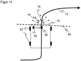
- FIG. 11 illustrates, in a further plan view of a vehicle 10, a procedure for a virtual code reader which avoids the problem of a reading area 44 not being aligned with sufficient precision.
- two alternative possible solutions are shown.
- a first possibility consists in dragging the detected additional codes 36 onto the track 12 as a virtual additional code 36′.
- a control command encoded in the additional code 36 is to be implemented at the point in time at which the additional code 36 is detected. This in turn corresponds to a specific position along track 12. Therefore, the position of the code can be reassigned to just one coordinate corresponding to the position along track 12. If the additional code 36 encodes an absolute position, this is used for the virtual additional code 36 corrected according to the offset to track 12.
- the virtual additional code 36' is considered to have been read when the vehicle 10 reaches the corresponding position on the lane 12.
- An alternative possibility that is mathematically equivalent in principle provides for replacing the rectangular or circular, narrowly delimited original reading area 44 in the virtual code reader with a virtual measuring line 46 that is arranged perpendicular to the track 12 in each case. As soon as the virtual measuring line 46 sweeps over the additional code 36 at its position learned in the card, the additional code 36 is considered to have been read and its control command is executed. Ultimately, the virtual measuring line 46 does nothing other than position the additional code 36 on a corresponding position on the Project track 12. Instead of a virtual measuring line 46, a rectangle with the width of the virtual measuring line 46 could also be used as the reading area 44.
- the extension of the virtual measuring line 46 is to be limited approximately to the width of the vehicle 10, since otherwise additional codes 36 that do not belong to the section of the lane 12 currently being traveled on would possibly also be taken into account.
- only virtual additional codes 36′ are drawn onto the track 12 which are sufficiently close to the track 12 that they would in principle be detected by a code reader.
Landscapes
- Engineering & Computer Science (AREA)
- Radar, Positioning & Navigation (AREA)
- Remote Sensing (AREA)
- Physics & Mathematics (AREA)
- General Physics & Mathematics (AREA)
- Automation & Control Theory (AREA)
- Aviation & Aerospace Engineering (AREA)
- Data Mining & Analysis (AREA)
- Electromagnetism (AREA)
- Theoretical Computer Science (AREA)
- Artificial Intelligence (AREA)
- Evolutionary Computation (AREA)
- Evolutionary Biology (AREA)
- Computer Vision & Pattern Recognition (AREA)
- General Engineering & Computer Science (AREA)
- Bioinformatics & Computational Biology (AREA)
- Bioinformatics & Cheminformatics (AREA)
- Life Sciences & Earth Sciences (AREA)
- Optics & Photonics (AREA)
- Navigation (AREA)
- Traffic Control Systems (AREA)
- Business, Economics & Management (AREA)
- Health & Medical Sciences (AREA)
- Game Theory and Decision Science (AREA)
- Medical Informatics (AREA)
- Instructional Devices (AREA)
Description
Die Erfindung betrifft ein Verfahren und eine Vorrichtung zum Erzeugen einer neuen hybriden Karte durch Erweitern und/oder Verändern einer ersten hybriden Karte mit einer zweiten hybriden Karte nach dem Oberbegriff von Anspruch 1 beziehungsweise 13.The invention relates to a method and a device for generating a new hybrid card by expanding and/or changing a first hybrid card with a second hybrid card according to the preamble of
Ein herkömmliches Navigationsverfahren für fahrerlose Transportfahrzeuge (AGV, Automated Guided Vehicle) basiert auf einer Spurführung durch eine physische Spur oder Leitlinie. Die Spur ist beispielsweise als optisch erfassbares Band oder als magnetisches Band auf den Boden geklebt oder in den Boden eingelassen und wird mittels geeigneter Sensorik detektiert, etwa einer Kamera oder einem Hall-Sensor. Ein solcher Spurführungssensor gibt den jeweiligen Abstands zur Mitte der Spur aus, und mit dieser Information wird die Fahrt derart geregelt, dass das Fahrzeug kontinuierlich der Spur folgt.A conventional navigation method for driverless transport vehicles (AGV, Automated Guided Vehicle) is based on lane guidance by a physical lane or guideline. The track is, for example, glued to the floor or embedded in the floor as an optically detectable tape or as a magnetic tape and is detected by means of suitable sensors, such as a camera or a Hall sensor. Such a lane guidance sensor outputs the respective distance to the center of the lane, and with this information the journey is controlled in such a way that the vehicle continuously follows the lane.
In Ergänzung der Spuren werden in einigen Fällen Zusatzmarkierungen verwendet, die an bestimmten Positionen Steuersignale an das Fahrzeug übermitteln, etwa um die Fahrt zu verlangsamen oder in eine bestimmte Richtung abzubiegen. Derartige Zusatzmarkierungen fungieren häufig als Positionscodes mit einer absoluten Positionsangabe in der Fahrzeugsteuerung bekannten Koordinaten. Zusatzmarkierungen werden entlang der Spur auf den Boden oder darin eingelassen. Das Fahrzeug verfügt über einen Codeleser in zu dem Zusatzcode passender Technologie, also einen optischen Codeleser für einen Barcode oder 2D-Code oder einen RFID-Leser für ein RFID-Tag.In addition to the lanes, additional markings are used in some cases, which transmit control signals to the vehicle at certain positions, for example to slow down or turn in a certain direction. Such additional markings often function as position codes with coordinates known as absolute position information in the vehicle control system. Additional markings are embedded on or in the ground along the track. The vehicle has a code reader with the right technology for the additional code, i.e. an optical code reader for a barcode or 2D code or an RFID reader for an RFID tag.
In den Boden eingelassene Spuren können nur mit hohem Aufwand verändert werden und kommen deshalb immer seltener zum Einsatz. Aufgeklebte Spuren lassen sich zwar einfacher verändern, sind jedoch einer hohen Belastung während des Betriebs der Anlage ausgesetzt. Durch Abnutzung und Verschmutzung kann es dann zu Fehlsteuerungen kommen, beziehungsweise das Fahrzeug ist nicht mehr in der Lage, auf der vorgegebenen Spur weiterzufahren, bis die Defekte durch Servicepersonal behoben sind.Tracks embedded in the ground can only be changed with great effort and are therefore used less and less. Glued tracks are easier to change, but they are subject to high loads during the operation of the system exposed. Wear and tear and dirt can then lead to incorrect steering, or the vehicle is no longer able to continue on the specified track until the defects have been rectified by service personnel.
Alternativ zu einer Spurführung sind Navigationsverfahren bekannt, die auf einer berührungslosen Konturerfassung der Umgebung basieren. Die natürlichen Konturen, an denen sich das Fahrzeug orientiert und lokalisiert, können überall oder an kritischen Stellen durch eigens angebrachte Reflektoren ergänzt oder ersetzt werden. Eine erforderliche Karte mit Konturinformationen der Umgebung wird entweder vorab erstellt oder entsteht während des Navigierens (SLAM, Simultaneous Localisation and Mapping). Hier muss das Fahrzeug mittels Pfadplanung selbständig seinen Weg finden. Das ist weitaus komplexer und aufwändiger als das oben genannte Verfahren mit Spurführung. Bei Störungen der Pfadplanung ist der Einsatz von geschultem Fachpersonal notwendig.As an alternative to lane guidance, navigation methods are known which are based on contactless contour detection of the surroundings. The natural contours, on which the vehicle is oriented and localized, can be supplemented or replaced everywhere or at critical points by specially fitted reflectors. A required map with contour information of the environment is either created in advance or is created during navigation (SLAM, Simultaneous Localization and Mapping). Here the vehicle has to find its own way by means of path planning. This is far more complex and expensive than the track guidance method mentioned above. In the event of disruptions to the path planning, the deployment of trained specialist personnel is necessary.
Um die Vorteile der Flexibilität der freien Navigation mit der einfachen Pfadplanung der Spurführung zu kombinieren, werden im Stand der Technik Navigationssysteme vorgeschlagen, die als virtuelle Spurführungssysteme bezeichnet werden können. Dabei fährt das Fahrzeug in einer Einlern- oder Umstellungsphase eine physische Spur ab und erzeugt sich eine Karte der Umgebung. Die Spur merkt sich das System virtuell als Fahrbahn oder Trajektorie. In einer dann spurfreien Betriebsphase navigiert das Fahrzeug anhand einer Konturvermessung der Umgebung und der Karte auf der vorgegebenen Trajektorie, so dass die ehemals physische Spur nun als virtuelle Spur wirkt. Das weitere Schicksal der physischen Spur ist dann ohne Belang. Dieses Vorgehen hat den Charme einer besonders einfachen Umrüstung, da die vorhandene physische Spur übernommen wird. Das virtuelle Spurführungssystem kann sogar die gleichen Steuerbefehle an die Fahrzeugsteuerung geben wie zuvor der ersetzte Spurführungssensor. Zusatzcodes können beim Einlernen ebenfalls erfasst und durch virtuelle Zusatzcodes an deren Positionen ersetzt werden.In order to combine the advantages of the flexibility of free navigation with the simple path planning of lane guidance, navigation systems which can be referred to as virtual lane guidance systems are proposed in the prior art. The vehicle follows a physical lane in a learning or conversion phase and creates a map of the environment. The system remembers the lane virtually as a lane or trajectory. In a then lane-free operating phase, the vehicle navigates on the specified trajectory using a contour measurement of the surroundings and the map, so that the formerly physical lane now acts as a virtual lane. The further fate of the physical trace is then irrelevant. This procedure has the charm of a particularly simple conversion, since the existing physical track is taken over. The virtual lane guidance system can even issue the same control commands to the vehicle controller as the lane guidance sensor it replaced before. Additional codes can also be recorded during teach-in and replaced by virtual additional codes at their positions.
Ein derartiges virtuelles Spurführungssystem ist beispielsweise in der nachveröffentlichten deutschen Patentanmeldung mit dem Aktenzeichen
Nun ergeben sich immer wieder Situationen, in denen die Karte veraltet ist. Beispielsweise haben sich Fahrwege verändert, insbesondere durch nachträgliches Editieren einer virtuellen Spur, es sind neue Gebiete hinzugekommen, Reflektoren ausgefallen oder zusätzlich aufgehängt worden, neue Zusatzcodes angebracht worden oder die Umgebung hat sich im Vergleich zu der ursprünglich kartierten Konturinformation erheblich verändert.There are always situations where the map is out of date. For example, routes have changed, in particular due to subsequent editing of a virtual track, new areas have been added, reflectors have failed or been additionally hung up, new additional codes have been attached or the environment has changed significantly compared to the contour information originally mapped.
Es ist bekannt, die Karte neu aufzunehmen. Die Neuaufnahme bringt jedoch viel Aufwand mit sich, da die komplette Umgebung neu abgefahren werden muss und jegliche manuelle Veränderungen der Karte verloren gehen beziehungsweise wiederholt werden müssen. Außerdem kann sich das Koordinatensystem verändern, womit die vom Nutzer gespeicherten Positionen ungültig werden und neu zu bestimmen sind. Manche Verfahren aktualisieren alternativ ihre Karte fortlaufend. Das verteilt aber letztlich die genannten Nachteile lediglich auf kleinere Schritte.It is known to retake the map. However, the re-recording involves a lot of effort, since the entire environment has to be traversed again and any manual changes to the map are lost or have to be repeated. In addition, the coordinate system can change, which means that the positions saved by the user become invalid and must be redetermined. Alternatively, some methods continuously update their map. Ultimately, however, this only distributes the disadvantages mentioned over smaller steps.
Die
Die
In der
Aus der
Die
Es ist daher Aufgabe der Erfindung, die Aktualisierung einer Karte zum Navigieren eines Fahrzeugs zu verbessern.It is therefore the object of the invention to improve the updating of a map for navigating a vehicle.
Diese Aufgabe wird durch ein Verfahren und eine Vorrichtung zum Erzeugen einer neuen hybriden Karte durch Erweitern und/oder Verändern einer ersten hybriden Karte mit einer zweiten hybriden Karte nach Anspruch 1 beziehungsweise 13 gelöst. Ein Fahrzeug, insbesondere ein autonomes Fahrzeug (AGV, automated guided vehicle) verwendet die hybride Karte zur Eigenlokalisierung beim Navigieren längs einer vorgegebenen Trajektorie, die durch eine Spur vorgegeben wird. Eine erste hybride Karte ist eine ursprüngliche Karte, die beispielsweise aus einer Teilkartierung stammt oder die bereits für eine gewisse Betriebsphase Verwendung gefunden hat. Diese erste hybride Karte wird nun mit Hilfe einer zweiten hybriden Karte modifiziert. Dabei kann ein Bereich hinzugefügt werden, den die erste hybride Karte nicht abgedeckt hat, es ist ein Bereich neu vermessen worden, oder die zweite Karte trägt eine Kombination aus beidem bei. Eine neu hybride Karte entsteht aus einer Vereinigung der ersten und zweiten hybriden Karte. Entsprechend können eine dritte und weitere hybride Karte schrittweise hinzugefügt werden.This object is achieved by a method and a device for generating a new hybrid map by expanding and/or changing a first hybrid map with a second hybrid map according to
Eine hybride Karte enthält mehrere Informationskategorien, die von unterschiedlichen Sensoren stammen können. Die hybride Karte weist demnach Informationen unterschiedlichen Typs auf. Eine der Informationskategorien betrifft die Spur oder die zu fahrende Trajektorie des Fahrzeugs. Eine weitere Informationskategorie betrifft die Umgebungskontur der Spur, die insbesondere bei einer Kartierungsfahrt längs der Spur mit einem Konturerfassungssensor aufgenommen wird.A hybrid map contains multiple categories of information that can come from different sensors. The hybrid card accordingly has information of different types. One of the categories of information relates to the lane or trajectory to be traveled by the vehicle. A further category of information relates to the surrounding contour of the track, which is recorded with a contour detection sensor, in particular during a mapping trip along the track.
Die Erfindung geht von dem Grundgedanken aus, eine Möglichkeit zu schaffen, mit der die hybride Karte nicht vollständig ausgetauscht wird. Stattdessen werden die Informationskategorien getrennt nach verschiedenen Regeln aktualisiert. Es wird dazu je Informationskategorie eine Übernahmeentscheidung getroffen, ob die neue hybride Karte jeweils Informationen dieser Informationskategorie aus der ersten hybriden Karte, der zweiten hybriden Karte oder eine Kombination von Informationen beider hybrider Karten übernimmt. Die Frage, ob in einer Informationskategorie Informationen übernommen werden, kann auch verneint werden. Dann fehlt in der neuen hybriden Karte die entsprechende Informationskategorie zumindest bereichsweise.The invention is based on the basic idea of creating a possibility with which the hybrid card is not completely exchanged. Instead, the information categories are updated separately according to different rules. For this purpose, a transfer decision is made for each information category as to whether the new hybrid card takes over information of this information category from the first hybrid card, the second hybrid card or a combination of information from both hybrid cards. The answer to the question of whether information is taken over in an information category can also be answered in the negative. Then the corresponding information category is missing in the new hybrid map, at least in some areas.
Die Erfindung hat den Vorteil, dass flexibel nur Teile einer Karte aktualisiert werden, d.h. räumlich begrenzte Teilbereiche und/oder nur bestimmte Informationskategorien, während andere Teile unangetastet bleiben. Der Aufwand der neuen Kartierung (Remapping) wird erheblich reduziert, da nur relevante Stellen mit Änderungen neu zu kartieren sind und nicht der gesamte Navigationsbereich. Die in der alten Karte eingetragenen Trajektorien können weiter zum Abfahren des vorgegebenen Wegs genutzt werden, auch wenn sie (inzwischen) rein virtuell sind. Bei einer vollständigen Neukartierung hingegen müssten Spuren physikalisch vorhanden sein, oder das Fahrzeug müsste auf andere Weise wie beispielsweise manuell gesteuert werden. Ebenso gehen in der alten Karte vorgenommene Änderungen, beispielsweise durch Editieren einer virtuellen Spur, nicht verloren. Das Koordinatensystem der alten Karte kann beibehalten werden, so dass gespeicherte Positionen ihr Gültigkeit behalten.The invention has the advantage that only parts of a map are flexibly updated, i.e. spatially limited partial areas and/or only specific categories of information, while other parts remain untouched. The effort of the new mapping (remapping) is significantly reduced, since only relevant places with changes have to be re-mapped and not the entire navigation area. The trajectories entered in the old map can still be used to follow the specified route, even if they are (meanwhile) purely virtual. In contrast, full remapping would require tracks to be physically present or the vehicle would need to be controlled in some other way, such as manually. Likewise, changes made in the old map, for example by editing a virtual track, are not lost. The coordinate system of the old map can be retained so that saved positions remain valid.
Die erste hybride Karte wird bevorzugt in einem ersten Kartierungsvorgang und/oder die zweite hybride Karte in einem zweiten Kartierungsvorgang zu einem späteren Zeitpunkt erzeugt, wobei bei einem Kartierungsvorgang das Fahrzeug die Spur zumindest teilweise abfährt und die Umgebungskontur der Spur mit einem Konturerfassungssensor aufnimmt. Während der Einlern- oder Referenzfahrt kann die Navigation noch mit einem herkömmlichen Spurführungssystem anhand einer physischen Spur erfolgen. Insbesondere das Nachkartieren, also die Erfassung der zweiten hybriden Karte, kann aber auch längs einer virtuellen Spur erfolgen. Außerdem ist gerade beim Nachkartieren nicht erforderlich, die gesamte Spur abzufahren. Es geht dabei darum, diejenigen Teilbereiche abzufahren, die einer Aktualisierung bedürfen. Ein bevorzugtes Vorgehen beim Kartieren ist in der einleitend schon genannten deutschen Patentanmeldung mit dem Aktenzeichen
In einer sich an die Kartierungen und das Zusammenfügen der ersten und zweiten hybriden Karte anschließenden Betriebsphase navigiert das Fahrzeug mit Hilfe der neuen hybriden Karte. Mit einem Konturerfassungssensor wird eine jeweilige Kontur der Umgebung des Fahrzeugs erfasst. Das ist vorzugsweise derselbe Konturerfassungssensor, der auch beim Kartieren verwendet wurde. Eine Umgebungskontur ist insbesondere eine Punktwolke, im allgemeinen eine 3D-Punktwolke, die aber beispielsweise auf eine Ebene beschränkt und damit effektiv nur eine 2D-Punktwolke sein kann, wie bei einem abstandsmessenden Laserscanner. Anhand der Umgebungskonturen wird wiederholt die eigene Pose des Fahrzeugs bestimmt und so navigiert. Dabei kann eine Pose in bis zu sechs Freiheitsgraden bestimmt werden, mit einer Position und/oder einer Ausrichtung des Fahrzeugs in jeweils einem bis drei Freiheitsgraden.In an operating phase following the mapping and the merging of the first and second hybrid map, the vehicle navigates with the aid of the new hybrid map. A contour detection sensor is used to detect a respective contour of the surroundings of the vehicle. This is preferably the same contour detection sensor used in mapping. A surrounding contour is, in particular, a point cloud, generally a 3D point cloud, which, for example, is restricted to one plane and can therefore effectively only be a 2D point cloud, as in the case of a distance-measuring laser scanner. Using the surrounding contours, the vehicle's own pose is repeatedly determined and thus navigated. A pose can be determined in up to six degrees of freedom, with a position and/or orientation of the vehicle in one to three degrees of freedom.
Die Übernahmeentscheidung wird bevorzugt durch eine Vorgabe je Informationskategorie getroffen, insbesondere durch Auswahl in einer Benutzeroberfläche. In dieser bevorzugten Ausführungsform gibt es eine Festlegung je Informationskategorie, welche Informationen aus der ersten hybriden Karte behalten, durch die zweite hybride Karte ersetzt, aus beiden zusammengesetzt oder womöglich gar nicht in die neue hybride Karte übernommen werden sollen. Diese Vorgabe kann insbesondere parametriert oder beispielsweise über eine Benutzeroberfläche eingegeben werden.The takeover decision is preferably made by a specification for each information category, in particular by selection in a user interface. In this preferred embodiment, there is a specification per category of information as to which information from the first hybrid card should be kept, replaced by the second hybrid card, composed of both, or possibly not included in the new hybrid card at all. In particular, this specification can be parameterized or entered, for example, via a user interface.
Alternativ wird die Übernahmeentscheidung automatisch getroffen. Dazu werden insbesondere je Informationskategorie programmierte Kriterien oder Regeln verwendet. Ein bevorzugter Regelsatz besagt: Wenn eine Information nur in der ersten oder der zweiten hybriden Karte vorhanden ist, wird sie in die neue hybride Karte übernommen; wenn eine Information in der ersten und zweiten hybriden Karte innerhalb eines Toleranzrahmens übereinstimmt, wird sie aus der ersten hybriden Karte übernommen; wenn eine Information in der zweiten hybriden Karte über einen Toleranzrahmen hinaus von der ersten hybriden Karte abweicht, wird sie aus der zweiten hybriden Karte übernommen. Damit wird der ersten hybriden Karte gerade so lange vertraut, wie sie keine Lücken aufweist oder die Neukartierung keine deutlichen Hinweise gibt, dass die Informationen veraltet sind. Diese Regeln können auch nur teilweise umgesetzt sein.Alternatively, the takeover decision is made automatically. For this purpose, programmed criteria or rules are used in particular for each information category. A preferred set of rules states: If a piece of information is only present in the first or the second hybrid map, it is carried over into the new hybrid map; if information in the first and second hybrid map matches within a tolerance range, it is taken from the first hybrid map; if information in the second hybrid map deviates from the first hybrid map beyond a tolerance range, it is taken from the second hybrid map. In order to the first hybrid map is trusted just as long as there are no gaps or remapping does not provide strong evidence that the information is out of date. These rules can also only be partially implemented.
Die Übernahmeentscheidung ist bevorzugt eine Auswahl, die Umgebungskontur aus der ersten hybriden Karte, der zweiten hybriden Karte, beiden hybriden Karten oder keiner hybriden Karte zu übernehmen. Eine derartige Auswahl wird vorzugsweise für alle Informationen einer Informationskategorie getroffen, also in dieser Ausführungsform für alle Umgebungskonturen, und dies gilt sinngemäß für die weiteren unten zu diskutierenden Informationskategorien. Mit der Auswahl nur der ersten hybriden Karte sollten Umgebungskonturen nicht verändert werden, während die Auswahl nur der zweiten hybriden Karte bedeutet, dass die Umgebungskontur überall überschrieben werden soll, zumindest wo neue Umgebungskonturen erfasst wurden. Eine Auswahl beider hybrider Karten führt zu einer Kombination der Umgebungskonturen. Ist gar keine hybride Karte gewählt, so enthält die neue hybride Karte auch keine Umgebungskonturen. Sie ist dann zum Navigieren nicht mehr geeignet, kann aber für andere Zwecke wie beispielsweise eine Diagnose noch nützlich sein.The adoption decision is preferably a selection to adopt the surrounding contour from the first hybrid map, the second hybrid map, both hybrid maps, or no hybrid map. Such a selection is preferably made for all information of an information category, ie in this embodiment for all surrounding contours, and this applies analogously to the other information categories to be discussed below. With the selection of only the first hybrid map, environmental contours should not be changed, while selecting only the second hybrid map means that the environmental contour should be overwritten everywhere, at least where new environmental contours have been detected. A selection of both hybrid maps leads to a combination of the surrounding contours. If no hybrid map is selected at all, the new hybrid map does not contain any surrounding contours. It is then no longer suitable for navigation, but can still be useful for other purposes such as diagnosis.
Die Übernahmeentscheidung ist bevorzugt eine Auswahl, die zu fahrende Trajektorie aus der ersten hybriden Karte, der zweiten hybriden Karte, beiden hybriden Karten oder keiner hybriden Karte zu übernehmen. Die Auswahl der ersten Karte bedeutet, dass die zu fahrende Trajektorie nicht verändert wird, beispielsweise, weil sie von Hand editiert wurde und möglicherweise die physische Spur, aus der sie hervorging, beschädigt oder gar nicht mehr vorhanden ist. Die Auswahl der zweiten hybriden Karte modifiziert die bisherige Trajektorie zumindest in den neu aufgenommenen Bereichen. Bei Auswahl beider Karten wird in überlappenden Abschnitten eine gemeinsame Trajektorie bestimmt. Erneut kann auch keine hybride Karte gewählt werden, somit dann die neue hybride Karte keine Spur oder Trajektorie mehr enthält, die dann beispielsweise noch in weiteren Schritten hinzugefügt wird.The takeover decision is preferably a selection to take over the trajectory to be traveled from the first hybrid map, the second hybrid map, both hybrid maps or no hybrid map. Choosing the first map means that the trajectory to be driven will not be altered, for example because it has been edited by hand and the physical track from which it originated may be corrupted or non-existent. The selection of the second hybrid map modifies the previous trajectory, at least in the newly recorded areas. If both maps are selected, a common trajectory is determined in overlapping sections. Again, no hybrid map can be selected, so then the new hybrid map no longer contains a track or trajectory, which is then added, for example, in further steps.
Die hybride Karte weist bevorzugt als Informationskategorie Reflektorpositionen und/oder Zusatzcodes, insbesondere Positionscodes auf. Bisher wurden nur eine erste Informationskategorie und eine zweite Informationskategorie konkret genannt, nämlich Spur beziehungsweise Trajektorie und Umgebungskontur. Eine mögliche dritte und/oder vierte Informationskategorie betrifft nun Reflektoren und die einleitend schon genannten Zusatzcodes. Reflektoren sind im Prinzip Teil der Umgebungskontur, jedoch mit besonders verlässlicher Erfassung und in der Regel auch besonders gut bekannten Positionen. Zusatzcodes enthalten im allgemeinen irgendeine Information für das Fahrzeug. Besonders bevorzugt werden dadurch sichere absolute Positionen erfasst, mit denen die Karte und die spätere Navigation immer wieder sicher verankert werden kann.The hybrid map preferably has reflector positions and/or additional codes, in particular position codes, as information categories. So far, only a first information category and a second information category have been specifically named, namely track or trajectory and surrounding contour. A possible third and/or fourth category of information relates to reflectors and those already mentioned in the introduction additional codes. In principle, reflectors are part of the surrounding contours, but with particularly reliable detection and generally also particularly well-known positions. Supplementary codes generally contain some information for the vehicle. In this way, secure absolute positions are particularly preferably recorded, with which the map and the subsequent navigation can always be securely anchored.
Die Übernahmeentscheidung ist bevorzugt eine Auswahl, die Reflektorpositionen aus der ersten hybriden Karte, der zweiten hybriden Karte, beiden hybriden Karten oder keiner hybriden Karte zu übernehmen. Diese Auswahl ist ganz ähnlich zu verstehen wie oben bei der Umgebungskontur. Der Unterschied ist, dass die Reflektorpopulation in der Regel absichtlich verändert wurde, um die Navigation zu unterstützen. Es ist jedoch durchaus auch umgekehrt vorstellbar, dass Reflektoren degradieren, verdeckt oder beschädigt werden oder ohne gezielte Maßnahme verloren gehen. Um der tatsächlichen Situation gerecht zu werden, kann es sinnvoll sein, die Reflektoren der ersten hybriden Karte zu behalten, nur die neuen Reflektoren der zweiten hybriden Karte zu übernehmen, alle Reflektoren beider Karten zu kombinieren oder gar keine Reflektoren in der neuen hybriden Karte zu berücksichtigen.The adoption decision is preferably a selection to adopt the reflector positions from the first hybrid map, the second hybrid map, both hybrid maps, or no hybrid map. This selection is to be understood in a very similar way to the surrounding contour above. The difference is that the reflector population has usually been intentionally altered to aid in navigation. Conversely, however, it is also conceivable that reflectors degrade, are covered or damaged or are lost without specific measures. In order to do justice to the actual situation, it may make sense to keep the reflectors of the first hybrid map, to only adopt the new reflectors of the second hybrid map, to combine all reflectors of both maps, or to consider no reflectors at all in the new hybrid map .
Die Übernahmeentscheidung ist bevorzugt eine Auswahl, die Zusatzcodes aus der ersten hybriden Karte, der zweiten hybriden Karte, beiden hybriden Karten oder keiner hybriden Karte zu übernehmen. Die Übernahme von Zusatzcodes der ersten hybriden Karte ist besonders dann sinnvoll, wenn die ursprünglichen Zusatzcodes beschädigt wurden oder gar nicht mehr existieren. Umgekehrt sollen möglicherweise nur die Informationen der nun vorhandenen Zusatzcodes verwendet werden, und dazu wird nur die zweite hybride Karte ausgewählt. Die Zusatzcodes beider hybrider Karten können kombiniert werden. Schließlich ist denkbar, Zusatzcodes zwar beim Kartieren und Zusammenfügen zu nutzen, dann aber nicht in die neue hybride Karte zu übernehmen, etwa weil im Navigationsbetrieb gar kein entsprechende Codeleser vorgesehen ist.The takeover decision is preferably a selection to take over the additional codes from the first hybrid card, the second hybrid card, both hybrid cards or no hybrid card. Adopting additional codes from the first hybrid card makes particular sense if the original additional codes have been damaged or no longer exist. Conversely, it is possible that only the information from the additional codes that are now present should be used, and only the second hybrid card is selected for this purpose. The additional codes of both hybrid cards can be combined. Finally, it is conceivable to use additional codes when mapping and assembling, but then not adopting them in the new hybrid map, for example because no corresponding code reader is provided in navigation mode.
Zusatzcodes werden bevorzugt einer Position längs der Spur zugeordnet. Beim Kartieren werden die Zusatzcodes mit einem Codeleser erfasst, der nur einen gewissen Erfassungsbereich aufweist. Diese Codeleser könnte für virtuelle Zusatzcodes bei der Navigation emuliert werden. Stattdessen ist es robuster, den Zusatzcodes eine Koordinate längs der Spur zuzuweisen. Die Spur bildet ja gleichsam ein eindimensionales Koordinatensystem für die Position des Fahrzeugs. Nach dieser bevorzugten Ausführungsform hängt es nicht von der geschätzten Ausrichtung des Fahrzeugs oder dem Lesebereich eines virtuellen Codelesers ab, ob und wann ein Zusatzcode als erfasst gilt. Eine Absolutposition eines Zusatzcodes wird bei der Zuordnung einer Spurkoordinate vorzugsweise entsprechend versetzt, wenn der Zusatzcode nicht auf der Spur lag. Gleichwertig dazu, den Zusatzcode in dieser Weise auf die Spur zu ziehen, ist ein virtueller Codeleser, für den ein Zusatzcode als erfasst gilt, sobald eine Linie senkrecht zur Spur den Zusatzcode überstrichen hat.Auxiliary codes are preferably assigned to a position along the lane. When mapping, the additional codes are recorded with a code reader that only has a certain detection range. This code reader could be emulated for additional virtual codes in navigation. Instead, it is more robust to assign a coordinate along the lane to the additional codes. The track forms a one-dimensional coordinate system for the position of the vehicle. According to this preferred embodiment, it does not depend on the estimated orientation of the vehicle or the reading range a virtual code reader determines whether and when an additional code is considered to be recorded. When assigning a track coordinate, an absolute position of an additional code is preferably offset accordingly if the additional code was not on the track. Equivalent to pulling the additional code onto the track in this way is a virtual code reader for which an additional code is considered to have been detected as soon as a line perpendicular to the track has crossed the additional code.
Die erste hybride Karte und die zweite Karte sind bevorzugt als Graphen repräsentiert, und die neue hybride Karte wird aus einer Verschmelzung der Graphen erzeugt. Ein Knoten eines solchen Graphen entspricht einer Position samt zugehörigen Zusatzinformationen, während Kanten relative Positionen zwischen Knoten beschreiben, die aus überlappenden Sensorinformationen bestimmt wurden. Die beiden Graphen und damit die hybriden Karten werden dann an mindestens einem Knoten miteinander verschmolzen, der einer identischen oder sehr ähnlichen Position entspricht. Anschließend wird der gemeinsame Graph vorzugsweise optimiert, und zwar unter Einhaltung der durch die Übernahmeentscheidung gestellten Bedingungen.The first hybrid map and the second map are preferably represented as graphs and the new hybrid map is created from a merging of the graphs. A node of such a graph corresponds to a position including additional information, while edges describe relative positions between nodes that were determined from overlapping sensor information. The two graphs, and thus the hybrid maps, are then merged together at at least one node that corresponds to an identical or very similar position. The joint graph is then preferably optimized, specifically in compliance with the conditions imposed by the takeover decision.
Die Übernahmeentscheidung berücksichtigt vorzugsweise die Bedingung, den Graph der ersten hybriden Karte unverändert zu lassen oder verändern zu dürfen. In einer Repräsentation als Graph kommt eine weitere vorteilhafte Bedingung hinzu, die für die Erzeugung der neuen hybriden Karte wahlweise gestellt sein kann oder nicht: Der Graph, der die erste hybride Karte repräsentiert, kann gleichsam eingefroren, somit unverändert in die neue hybride Karte übernommen werden, oder es kann erlaubt werden, dass auch dessen Knoten in eine Optimierung des gemeinsamen Graphen einbezogen werden. Das Erhalten des ursprünglichen Graphen hat den Vorteil, dass die alten Positionen und Koordinaten sich nicht ändern. Ohne diese Bedingung gelingt in der Regel eine bessere Optimierung, allerdings um den Preis, dass sich das Koordinatensystem verändern kann und sich auch Strukturen verformen können.The takeover decision preferably takes into account the condition of being able to leave the graph of the first hybrid map unchanged or to be able to change it. In a representation as a graph, there is another advantageous condition that can be set for the generation of the new hybrid map or not: The graph that represents the first hybrid map can be frozen, so to speak, so it can be used unchanged in the new hybrid map , or its nodes can also be allowed to be included in an optimization of the joint graph. Preserving the original graph has the advantage that the old positions and coordinates do not change. Without this condition, better optimization is usually possible, but at the price that the coordinate system can change and structures can also deform.
Die Spur ist bevorzugt eine virtuelle Spur, die insbesondere aus einer physischen Spur eingelernt wird. Anfänglich gibt es demnach eine physische Spur, wie eine optische oder magnetische Spur auf dem Boden. Daraus wird eine virtuelle Spur eingelernt, die demnach nur noch in Form entsprechender Daten existiert. Die virtuelle Spur kann rein virtuell verändert und prinzipiell auch rein virtuell vorgegeben sein, beispielsweise mit Hilfe einer graphischen Benutzeroberfläche auf einem Konfigurationsrechner. Durch Einlernen auf Basis einer physischen Spur wird, wie einleitend schon erklärt, die Umstellung auf eine Navigationslösung mit Konturerfassungssensoren erheblich vereinfacht.The track is preferably a virtual track that is learned in particular from a physical track. Initially, then, there is a physical track, such as an optical or magnetic track on the ground. A virtual track is learned from this, which then only exists in the form of corresponding data. The virtual track can be changed purely virtually and in principle can also be predetermined purely virtually, for example with help a graphical user interface on a configuration computer. As already explained in the introduction, learning based on a physical lane considerably simplifies the switch to a navigation solution with contour detection sensors.
Die spätere Navigation auf der vorgegebenen Trajektorie erfolgt vorzugsweise durch jeweilige Korrekturen der Fahrzeugpose in Richtung auf die Spur. Die konkreten Steueranweisungen, mit denen die Pose so korrigiert wird, entsprechen der Regelung eines herkömmlichen Spurführungssystems mit physischer Spur. Das erleichtert eine Umrüstung noch weiter, da die Fahrzeugsteuerung letztlich dieselben Informationen beziehungsweise Befehle erhält wie zuvor.Subsequent navigation on the specified trajectory is preferably carried out by correcting the vehicle pose in the direction of the lane. The specific control instructions used to correct the pose in this way correspond to the control of a conventional physical track guidance system. This makes retrofitting even easier, since the vehicle controller ultimately receives the same information or commands as before.
In bevorzugter Weiterbildung wird eine Vorrichtung zum Erzeugen einer neuen hybriden Karte für die Navigation eines Fahrzeugs durch Erweitern und/oder Verändern einer ersten hybriden Karte mit einer zweiten hybriden Karte bereitgestellt. Die Vorrichtung weist einen Konturerfassungssensor zur Erfassung einer Umgebungskontur einer Umgebung des Fahrzeugs und eine Steuer- und Auswertungseinheit auf, in der ein erfindungsgemäßes Verfahren implementiert ist. Das Verschmelzen von zwei hybriden Karten zu einer neuen hybriden Karte kann offline erfolgen, daher kann die Steuer- und Auswertungseinheit zumindest teilweise unabhängig vom Fahrzeug vorgesehen sein, beispielsweise in einem nur vorübergehend angeschlossenen Rechner, einem Netzwerk oder einer Cloud. Die Vorrichtung umfasst vorzugsweise einen Spurfolgesensor, um zumindest bei der Kartierung der ersten und/oder zweiten hybriden Karte, möglicherweise auch noch unterstützend bei der späteren Navigation, einer physischen Spur zu folgen.In a preferred development, a device is provided for generating a new hybrid map for navigating a vehicle by expanding and/or changing a first hybrid map with a second hybrid map. The device has a contour detection sensor for detecting an environmental contour of an environment of the vehicle and a control and evaluation unit in which a method according to the invention is implemented. The merging of two hybrid maps to form a new hybrid map can take place offline, so the control and evaluation unit can be provided at least partially independently of the vehicle, for example in a computer, network or cloud that is only temporarily connected. The device preferably comprises a lane-following sensor in order to follow a physical lane at least when mapping the first and/or second hybrid map, possibly also supporting the subsequent navigation.
Das erfindungsgemäße Verfahren kann auf ähnliche Weise weitergebildet werden und zeigt dabei ähnliche Vorteile. Derartige vorteilhafte Merkmale sind beispielhaft, aber nicht abschließend in den sich an die unabhängigen Ansprüche anschließenden Unteransprüchen beschrieben.The method according to the invention can be developed in a similar way and shows similar advantages. Such advantageous features are described by way of example but not exhaustively in the dependent claims which follow the independent claims.
Die Erfindung wird nachstehend auch hinsichtlich weiterer Merkmale und Vorteile beispielhaft anhand von Ausführungsformen und unter Bezug auf die beigefügte Zeichnung näher erläutert. Die Abbildungen der Zeichnung zeigen in:
- Fig. 1
- eine schematische Darstellung eines Fahrzeugs mit Konturvermessungssensor, das entlang einer virtuellen Spur navigiert;
- Fig. 2
- eine beispielhafte Karte einer Umgebungskontur sowie der anhand einer Spur vorgegebenen Trajektorie eines Fahrzeugs;
- Fig. 3
- eine beispielhafte zweite Karte, mit der die
Karte gemäß Figur 2 modifiziert werden soll; - Fig.4
- eine aus den Karten gemäß
Figur 23 zusammengesetzte neu Karte; - Fig. 5
- eine beispielhafte Auswahl, welche Informationskategorien zweier zusammenzufügender Karten jeweils in eine neue Karte übernommen werden sollen;
- Fig. 6
- eine beispielhafte Karte zur Illustration hinzugefügter Reflektoren;
- Fig. 7a-b
- beispielhafte Karten zur Illustration einer veränderten Umgebungskontur im Ausgangszustand und im modifizierten Zustand der Karten;
- Fig. 8a-b
- beispielhafte Karten zur Illustration veränderter Zusatzcodes im Ausgangszustand und im modifizierten Zustand der Karten;
- Fig. 9
- eine beispielhafte Karte, der ein neuer Bereich hinzugefügt wird;
- Fig. 10
- eine Draufsicht auf ein Fahrzeug mit einem Codeleser beim Vorbeifahren an einem Zusatzcode; und
- Fig. 11
- eine Draufsicht ähnlich
Figur 10 , wobei der Zusatzcode nun auf die Spur gezogen wird beziehungsweise beim Überstreichen mit einer zur Spur senkrechten Linie als gelesen gilt.
- 1
- a schematic representation of a vehicle with a contour measurement sensor navigating along a virtual lane;
- 2
- an exemplary map of an environmental contour as well as the trajectory of a vehicle specified using a lane;
- 3
- an exemplary second map, with which the map according to
figure 2 to be modified; - Fig.4
- one from the cards according to
figure 2 and3 composite new card; - figure 5
- an exemplary selection of which information categories of two maps to be combined are to be transferred to a new map;
- 6
- an example map to illustrate added reflectors;
- Fig. 7a-b
- exemplary maps to illustrate a changed surrounding contour in the initial state and in the modified state of the maps;
- Fig. 8a-b
- exemplary cards to illustrate changed additional codes in the initial state and in the modified state of the cards;
- 9
- an example map to which a new area is added;
- 10
- a plan view of a vehicle with a code reader when driving past an additional code; and
- 11
- similar to a top view
figure 10 , whereby the additional code is now drawn onto the track or counts as read when it is swept over with a line perpendicular to the track.
Eine Steuer- und Auswertungseinheit 18 ist mit dem Konturerfassungssensor 14 verbunden, um dessen Konturmessdaten auszuwerten, in einer noch zu beschreibenden Weise in einer Einlernphase eine Karte der Umgebung des Fahrzeugs 10 zu erstellen sowie dann in einer darauffolgenden Betriebsphase anhand der Karte zu navigieren. Die Steuer- und Auswertungseinheit 18 wiederum steht in Kommunikationsverbindung mit einer Fahrzeugsteuerung 20. Die Fahrzeugsteuerung 20 wirkt auf die Räder 22 oder deren Achsen ein, um das Fahrzeug zu beschleunigen, zu bremsen und zu lenken. Umgekehrt kann die Fahrzeugsteuerung 20 von den Rädern 22 auch Sensorinformationen erhalten. Steuer- und Auswertungseinheit 18 kann zumindest teilweise in dem Konturerfassungssensor 14 implementiert sein. Die klare Trennung von Steuer- und Auswertungseinheit 18 und Fahrzeugsteuerung 20 nur beispielhaft zu verstehen. Zumindest Teile der Steuer- und Auswertungseinheit 18 können außerhalb des Fahrzeugs 10 vorgesehen sein, etwa in einem damit drahtlos verbundenen Rechner, einem Netzwerk oder einer Cloud. Auf diese externe Weise kann insbesondere das Erstellen beziehungsweise Modifizieren einer Karte auf Basis von Messdaten des Konturerfassungssensors 14 erfolgen.A control and
Das Fahrzeug 10 navigiert in einer bevorzugten Ausführungsform zunächst in einer Einlernphase mit Hilfe von nicht gezeigten, an sich bekannten Spurführungssensoren, die eine physische Spur 12 erfassen. Dabei ist der Konturerfassungssensor 14 aktiv und erzeugt Konturinformationen der Umgebung der Spur 12, die zu einer Karte kombiniert werden. Im weiteren Betrieb ist dann die physische Spur 12 verzichtbar und durch eine virtuelle Spur 12 ersetzt, die lediglich noch die gewünschte Trajektorie angibt. Die Navigation erfolgt dann anhand einer Lokalisierung des Fahrzeugs 10 mittels eines Abgleichs aktuell mit dem Konturerfassungssensor 14 aufgenommener Konturinformationen und der Karte. Die Steuer- und Auswertungseinheit 18 kann auch anhand der virtuellen Spur 12 und der Konturinformationen für die Fahrzeugsteuerung 20 gleichartige Steuerungsdaten erzeugen wie zuvor mit dem Spurführungssensor aus der physischen Spur 12. Das hier nur zusammenfassend erläuterte Prinzip eines virtuellen Spurführungssensors mit Erstellen einer Karte und späterer Lokalisierung und Navigation anhand der Karte wird ausführlich in der deutschen Patentanmeldung mit dem Aktenzeichen
Obwohl die Erzeugung einer einzelnen Karte als bekannt vorausgesetzt wird und die Erfindung das Zusammensetzen zweier Karten für eine Aktualisierung betrifft (Update, Remapping), ist es für das weitere Verständnis hilfreich, zunächst die einzelnen Schritte einer automatisierten Kartierung kurz vorzustellen. Dieses beispielhafte vorteilhafte Vorgehen ist jedoch durch andere Wege ersetzbar, zu einer Karte mit den entsprechenden Informationen zu kommen.Although the generation of a single map is assumed to be known and the invention relates to the combination of two maps for an update (update, remapping), it is helpful for further understanding to first describe the individual steps an automated mapping. However, this exemplary advantageous procedure can be replaced by other ways of arriving at a map with the corresponding information.
Während mindestens einer Aufnahme- oder Kartierungsfahrt längs der Spur 12 wird die Eigenbewegung des Fahrzeugs 10 aus den Messdaten des Konturerfassungssensors 14 geschätzt. Die Spur 12 ist in dieser Phase vorzugsweise noch physisch vorhanden und wird von mindestens einem Spurerfassungssensor aufgenommen. Etwaige Zusatzcodes längs der Spur 12 werden mit einem Codeleser gelesen. Die erfassten Konturen, Spuren und Codedaten werden vorverarbeitet und gespeichert. Anhand der geschätzten Eigenbewegung werden die Daten in einer Karte angeordnet.During at least one recording or mapping trip along the
Dabei summieren sich jedoch Fehler in der Schätzung der Eigenbewegung über die Zeit auf, und dadurch entstehen Inkonsistenzen in der Karte. Eine Möglichkeit, solche Fehler zu korrigieren, bieten bereits besuchte Positionen, die das Fahrzeug 10 erneut überfährt, sogenannte Loop-Closures. Besonders vorteilhaft sind Loop-Closures an Positionen mit einem Zusatzcode, der die entsprechende Absolutposition enthält und somit einen verlässlichen Ankerpunkt bildet.However, errors in the estimation of proper motion accumulate over time, and this creates inconsistencies in the map. Positions that have already been visited and that the
Eine besonders vorteilhafte Repräsentation der Karte ist ein Graph, dessen Knoten Positionen und dessen Kanten Verbindungen längs der Spur 12 sind. In
In einer solchen Repräsentation kann eine Graph-basierte Optimierung die Loop-Closures 28 verwenden, um Fehler in der Schätzung der Eigenbewegung zu korrigieren. An der Position eines Loop-Closures 28 werden die jeweiligen Positionen aufeinandergelegt, beziehungsweise falls durch Zusatzcode eine Absolutposition bekannt ist, auf diese Absolutposition verschoben. Diese Verschiebung wird dann durch die Optimierung auf die übrigen Knoten 26a-b verteilt. Bei einer Bewegung eines Knotens 26a-b werden angehängte Kontur-, Spur- und Codedaten mitbewegt.In such a representation, a graph-based optimization can use the
Zur weiteren Verbesserung der Karte kann die erfasste Spur 12 nicht lediglich in die Karte eingetragen, sondern auch algorithmisch verwendet werden. Mehrfach erfasste Spuren 12, sei es aus mehreren Besuchen derselben Position oder durch die Verwendung multipler Spurführungssensoren, werden aufeinander gezogen beziehungsweise zu einer einzigen Spur 12 vereint. Auch mehrfach gelesene Zusatzcodes werden an einer Position vereinigt.In order to further improve the map, the detected
Die beiden verbundenen Graphen können nun wie oben zu
Prinzipiell ist denkbar, sämtliche Informationen der kombinierten Karte gemeinsam zu optimieren. Dann werden alle alten und neuen Informationen in einer möglichst genauen neuen Karte zusammengetragen. Erfindungsgemäß soll aber die Möglichkeit geschaffen werden, eine gezielte Übernahmeentscheidung zu treffen, so dass die Kartenaktualisierung nur einen Teil der Karte betreffen. Damit ist nicht nur eine örtliche Beschränkung gemeint, obwohl dies denkbar ist. Die hier verwendeten Karten sind sogenannte hybride Karten, weil sie mehrere unterschiedliche Informationskategorien umfassen. Es soll möglich sein, je Informationskategorie zu entscheiden, wie die Informationen aus den beiden Ausgangskarten in die neue Karte übernommen werden.In principle, it is conceivable to jointly optimize all of the information on the combined map. Then all the old and new information is compiled into a new map that is as accurate as possible. According to the invention, however, the possibility should be created of making a targeted acceptance decision, so that the map update only affects part of the map. So that's not just a local restriction meant, although this is conceivable. The maps used here are so-called hybrid maps because they contain several different categories of information. It should be possible to decide for each information category how the information from the two original maps is transferred to the new map.
Die Informationskategorien gemäß
Eine erste Informationskategorie betrifft eine Repräsentation als Graph und fixiert, wenn entsprechend ausgewählt, die Knoten des Graphen der ersten Karte. Einer Optimierung des verschmolzenen Graphen ist demnach verboten, die bereits aus der ersten Karte bekannten Knoten zu verschieben. Dies hat den Vorteil, dass sich bereits bekannte Positionen und das Koordinatensystem der Karte nicht verändern. Damit behalten auch durch den Benutzer gespeicherte Positionen ihre Gültigkeit. Allerdings bleibt zugleich die Chance ungenutzt, frühere Optimierungsfehler in der ersten Karte auszugleichen. Eine entsprechende Wahlmöglichkeit zur Fixierung von Knoten für die zweite Karte ist im Übrigen nicht sinnvoll, da es lediglich verbieten würde, Optimierungsmöglichkeiten zu nutzen, ohne dass dem Vorteile gegenüberstünden, da es in der zweiten Karte keine bisher schon genutzten bekannten Positionen oder Koordinaten gibt.A first category of information relates to a representation as a graph and, if appropriately selected, fixes the nodes of the graph of the first map. An optimization of the merged graph is therefore forbidden to shift the nodes already known from the first map. This has the advantage that already known positions and the coordinate system of the map do not change. This means that positions saved by the user remain valid. At the same time, however, the opportunity to compensate for earlier optimization errors in the first map remains unused. A corresponding option for fixing nodes for the second map does not make sense, since it would only prohibit using optimization options without any advantages, since there are no previously used known positions or coordinates in the second map.
Werden alternativ die Knoten der ersten Karte freigegeben, so ist lediglich ein Knoten fixiert, um die Konvergenz der Optimierung zu gewährleisten. Alle übrigen Knoten aus beiden Graphen können ihre Positionen verändern. Dadurch kann die Karte verformt oder an eine andere Position im Koordinatensystem bewegt werden. Das Koordinatensystem der neuen Karte passt somit nicht mehr zur ursprünglichen ersten Karte, und dies je nach Situation nicht lediglich in Form eines Versatzes, sondern sogar einer Verformung von Strukturen. Wenn jedoch beispielsweise der Benutzer nicht auf die metrischen Positionen angewiesen ist, etwa weil lediglich dem durch die Spur 12 vorgegebene Fahrweg gefolgt werden soll, so werden mehr Freiheiten für die Optimierung geschaffen, um Fehler zu korrigieren. Es entsteht eine genauere neue Karte, in der unter Umständen sogar frühere Fehler der ersten Karte aus den zusätzlichen Informationen der zweiten Karte verringert werden. In diesem Modus können Karten aus einzelnen Teilstücken zusammengesetzt werden, was sich nutzen lässt, um die Kartierung in mehreren getrennten Aufnahmefahrten durchzuführen, statt den vollständigen Parcours in einem Stück abfahren zu müssen.Alternatively, if the nodes of the first map are released, only one node is fixed to ensure the convergence of the optimization. All other nodes from both graphs can change their positions. This can deform the card or moved to another position in the coordinate system. The coordinate system of the new map therefore no longer fits the original first map, and depending on the situation not only in the form of an offset, but even a deformation of structures. However, if, for example, the user is not dependent on the metric positions, for example because only the route specified by
Eine zweite Informationskategorie betrifft die Konturen 24, die von dem Konturerfassungssensor 14 aufgenommen wurden. Die Konturen 24 werden vorzugsweise unabhängig von der Auswahl während der Optimierung noch beibehalten und beispielsweise für die Suche nach Loop-Closures 28, 30 verwendet. Abschließend in die neue Karte übernommen werden sie jedoch gemäß der Auswahl.A second category of information relates to the
Sind Konturen 24 nur aus der ersten Karte gewählt, so werden die neuen Vermessungen von Konturen 24 der zweiten Karte ignoriert. Beispielsweise ist die zweite Karte deshalb aufgenommen worden, weil sich die Spur 12 beziehungsweise die zu fahrende Trajektorie verändert hat oder Zusatzcodes verändert wurden. Die Konturen 24 selbst haben sich jedoch für die Lokalisierung bewährt und wurden eventuell schon manuell bearbeitet, so dass diesbezüglich keine Änderung gewünscht ist. Umgekehrt können Konturen nur aus der zweiten Karte gewählt sein. Dann haben sich die Strukturen in der Umgebung deutlich verändert, etwa weil Regale oder Stellwände umgestellt wurden, so dass die ursprünglichen Konturen 24 nicht mehr gut für die Lokalisierung geeignet sind.If
Konturen 24 aus beiden Karten in die neue Karte zu übernehmen ist beispielsweise sinnvoll, wenn der kartierte Bereich erweitert wurde, also neue Bereich zugänglich wurden. Soll die neue Karte gar keine Konturen 24 enthalten, so ist diese Karte für eine Navigation nur noch sehr begrenzt verwendbar, da kein Abgleich für eine Korrektur der Lokalisierung mehr möglich ist. Möglicherweise will aber der Benutzer lediglich Spuren 12 oder Zusatzcodes in eine CAD-Zeichnung übernehmen oder dergleichen, wofür die Option angeboten wird.It makes sense, for example, to transfer
Eine dritte Informationskategorie betrifft Reflektoren. Solche Reflektoren werden überall oder an besonders kritischen Stellen angebracht, um durch besonders verlässliche Erfassung durch den Konturerfassungssensor 14 die Navigation weiter zu unterstützen. Im Prinzip können daher Reflektoren als Teil der Kontur 24 verstanden werden, so dass die Erläuterungen weitgehend übertragbar sind. Reflektorinformationen werden vorzugsweise unabhängig von der Auswahl während der Optimierung beispielsweise für die Suche nach Loop-Closures 28, 30 verwendet. Die Auswahl legt dann fest, in welcher Form sie abschließend in die neue Karte übernommen werden.A third category of information concerns reflectors. Such reflectors are attached everywhere or at particularly critical points in order to further support navigation through particularly reliable detection by the
Sind Reflektoren nur der ersten Karte gewählt, so werden etwaige mit der zweiten Karte zusätzlich erfasste Reflektoren ignoriert. Das ist dann sinnvoll, wenn die Änderungen, derentwegen die Karte aktualisiert wird, die Konturen 24, die Spur 12 und/oder Zusatzcodes betrifft, sich jedoch die bisherigen Reflektorpositionen bewährt haben und womöglich schon manuell bearbeitet wurden. Sind umgekehrt nur Reflektoren der zweiten Karte gewählt, so werden die bisherigen Reflektoren der ersten Karte verworfen und durch die neuen Reflektoren der zweiten Karte ersetzt. Beispielsweise ist die Reflektorpopulation stark verändert worden, indem sowohl alte Reflektoren entfernt als auch neue Reflektoren aufgehängt wurden. Vorzugsweise ist die zweite Karte in einer Weise aufgenommen worden, dass alle aktuell vorhandenen Reflektoren erfasst werden konnten.If reflectors are only selected for the first card, any additional reflectors recorded with the second card are ignored. This makes sense if the changes for which the map is updated affect the
Sind Reflektoren beider Karten angewählt, so werden alle bekannten Reflektoren übernommen und überlappende Erfassungen desselben Reflektors verschmolzen. Beispielfälle sind eine Erweiterung des Navigationsbereichs oder das Anbringen zusätzlicher Reflektoren an bestimmten Stellen, um dort die Lokalisierung zu verbessern. Auch hinsichtlich der Reflektoren besteht die Möglichkeit, sie gar nicht in die neue Karte einzufügen. Ein Grund dafür könnte sein, dass es zu viele Fehlmessungen von Reflektoren gibt, beispielsweise, weil Arbeiter in der Umgebung Reflektorbänder tragen.If reflectors of both cards are selected, all known reflectors are taken over and overlapping measurements of the same reflector are merged. Example cases are an extension of the navigation area or the attachment of additional reflectors at certain points in order to improve localization there. With regard to the reflectors, there is also the option of not including them in the new map at all. One reason for this could be that there are too many incorrect measurements from reflectors, for example because workers in the area wear reflector bands.
Eine vierte Informationskategorie betrifft die Spur 12 beziehungsweise den davon vorgegebenen Fahrweg oder die Trajektorie des Fahrzeugs 10. Wiederum werden Daten der Spur 12 in der Optimierung vorzugsweise unabhängig von der Auswahl noch benutzt, etwa um wie oben zu
Bei Auswahl nur der ersten Karte bleibt die Fahrbahn unverändert. Die Änderungen, die eine Aktualisierung der Karte erforderten, betreffen demnach nicht die vorgesehene Trajektorie. Möglicherweise ist die Spur 12 physikalisch schon gar nicht mehr vorhanden und daher nur auf diesem Wege zu bewahren, oder der Fahrweg wurde manuell nachbearbeitet. Wird umgekehrt nur die zweite Karte als Quelle der neuen Spur 12 gewählt, so hat sich die gewünschte Fahrbahn verändert, und die alten Wege sollen nur insoweit noch befahren werden, wie das auch aktuell in der zweiten Karte noch vorgegeben wird. Für diese Option sollten alle neuen Wege abgefahren und somit in der zweiten Karte erfasst worden sein.If only the first map is selected, the lane remains unchanged. The changes that required updating the map do not therefore affect the planned trajectory. It is possible that track 12 no longer physically exists and can therefore only be preserved in this way, or the route was manually reworked. Conversely, if only the second map is selected as the source of the
Werden beide Karten als Quelle der neuen Spur zugelassen, so werden sämtliche Spurdaten übernommen. Überlappende Spuren werden zu einer einzigen Spur zusammengefasst, ähnlich wie oben zu
Eine fünfte Informationskategorie betrifft Zusatzcodes. Auch Zusatzcodes können unabhängig von der Auswahl während der Optimierung genutzt werden, insbesondere um Loop-Closures 28, 30 zu erkennen und zu lokalisieren. Allerdings ist zu beachten, dass aus der ersten Karte bekannte Zusatzcodes möglicherweise nicht vorhanden oder verschoben worden sind.A fifth category of information relates to suffix codes. Additional codes can also be used independently of the selection during the optimization, in particular to recognize and localize
Bei der Auswahl von Zusatzcodes nur der ersten Karte haben sich deren Positionen nicht verändert. Möglicherweise sind zumindest einige Zusatzcodes physisch gar nicht mehr vorhanden, sondern werden nur noch virtuell verwendet. Umgekehrt werden bei Auswahl von Zusatzcodes nur der zweiten Karte sämtlich bisher bekannten Zusatzcodes der ersten Karte verworfen. Es sollte darauf geachtet werden, dass die zweite Karte sämtliche noch relevanten Zusatzcodes umfasst.When selecting additional codes for only the first card, their positions have not changed. It is possible that at least some additional codes are no longer physically available, but are only used virtually. Conversely, when selecting additional codes for only the second card, all of the previously known additional codes for the first card are discarded. It should be ensured that the second card includes all additional codes that are still relevant.
Eine Kombination von Zusatzcodes aus beiden Karten übernimmt sämtliche nur in einer Karte erfassten Zusatzcodes. Werden Zusatzcodes in beiden Karten an sehr nahen Positionen erfasst, oder handelt es sich um eindeutige Zusatzcodes, die in beiden Karten vorkommen, so werden sie vorzugsweise in der neuen Karte verschmolzen, beziehungsweise die Karten werden in einer Weise vereinigt, die mit dem doppelt erfassten Zusatzcode verträglich ist. Anwendungsfälle sind die Erweiterung des Navigationsbereichs mit weiteren Zusatzcodes in den neuen Gebieten und/oder das Anbringen weiterer Zusatzcodes in bekannten Bereichen, um die Lokalisierung zu unterstützen oder dem Fahrzeug 10 zusätzliche Steuerungsanweisungen zu geben. Die Option, keine Zusatzcodes in die neue Karte zu übernehmen, ist beispielsweise dann sinnvoll, wenn das Fahrzeug 10 überhaupt nicht über einen Codeleser verfügt.A combination of additional codes from both cards accepts all additional codes recorded in only one card. If ancillary codes are detected in both cards at very close positions, or if they are unique ancillary codes common to both cards, they are preferably merged into the new card, or the cards are combined in a way consistent with the duplicated ancillary code is tolerable. Use cases are the extension of the navigation area with further additional codes in the new areas and/or the attachment of further additional codes in known areas in order to support the localization or to give the
Nach dieser Beschreibung der einzelnen Informationskategorien und der Auswahlmöglichkeiten innerhalb der Informationskategorie zum Vereinigen zweiter Karten wird nun eine Reihe von Beispielen betrachtet. Dabei handelt es sich um besonders praxisrelevante Fälle, in denen eine Aktualisierung der Karte erforderlich oder nützlich ist. Das soll jedoch die möglichen Kombinationen von Auswahlmöglichkeiten nicht einschränken.Having described each category of information and the choices within the category of information for merging two cards, a number of examples will now be considered. These are particularly practical cases in which an update of the map is necessary or useful. However, this is not intended to limit the possible combinations of choices.
Eine vorteilhafte Auswahl gemäß
Mit dieser Auswahl werden die neuen Reflektoren 32 zusätzlich in die neue Karte eingetragen. Soweit schon in der ersten Karte Reflektoren erfasst waren, bleiben sie erhalten. Überlappende Reflektoren aus beiden Karten werden verschmolzen. In den übrigen Informationskategorien bleibt die erste Karte unangetastet.With this selection, the
In diesem Beispiel wird gleich die neue Karte dargestellt. Dem liegt eine Vereinigung einer ursprünglichen ersten Karte ohne die Reflektoren 32 und einer zweiten Karte mit zumindest denjenigen Ausschnitten zugrunde, in denen die Reflektoren 32 erfasst sind.In this example, the new map is displayed immediately. This is based on a combination of an original first map without the
Die
Hier sind die Spuren 12 bereits kartiert oder sogar manuell editiert, beispielsweise indem der linke Bogen als virtuelle Spur hinzugefügt wurde. Dann hat sich jedoch die Umgebung derart verändert, dass kein zuverlässiger Abgleich mit der bisherigen Karte mehr möglich ist. Deshalb soll die Umgebung neu kartiert werden, aber die Fahrwege sollen bestehen bleiben. Bei einer vollständigen Neukartierung würde insbesondere ein manuell hinzugefügter Teil des Fahrwegs verschwinden.Here the
Eine vorteilhafte Auswahl gemäß
Damit bleiben die Spuren 12 und Zusatzcodes der ersten Karte erhalten, während die veränderte Umgebung in Kontur 24 und Reflektoren neu aufgenommen wird. Die Auswahl hinsichtlich der Zusatzcodes könnte innerhalb dieses Anwendungsfalls variiert werden, je nachdem, ob sich diesbezüglich in der Navigationsumgebung etwas verändert hat oder nicht. Im dargestellten Beispiel der
Die
In diesem Anwendungsfall soll die erste Karte weitgehend unverändert bleiben, jedoch sollen die Zusatzcodes 36 neu erfasst und eingetragen werden, wobei hier beispielhaft angenommen wird, dass die Veränderungen in den Zusatzcodes 36 so gravierend waren, dass die bisherige diesbezügliche Information gar nicht mehr verwendbar ist.In this application, the first card should remain largely unchanged, but the
Eine vorteilhafte Auswahl gemäß
Eine vorteilhafte Auswahl gemäß
Bei dieser Auswahl wird unterstellt, dass es praktisch nicht zu Konflikten zwischen den Informationen der beiden Karten kommt, weil die Karten unterschiedliche Gebiete abdecken. Genau das war ja das Ausgangsszenario, in dem verhindert werden sollte, dass die zweite Karte das Gebiet der ersten Karte nochmals erfasst.This selection assumes that there are practically no conflicts between the information on the two maps because the maps cover different areas. That was exactly the initial scenario, in which it should be prevented that the second map covers the area of the first map again.
Ohne eigene Darstellung in einer Figur soll noch ein weiterer Anwendungsfall diskutiert werden. Dabei geht es darum, dass eine erste Karte mit einer anderen Sensorkonfiguration, insbesondere einem anderen Konturerfassungssensor 14 aufgenommen wurde, als sie nun das Fahrzeug 10 zum Navigieren nutzen wird. Insbesondere sollen mehrere Fahrzeuge 10 zumindest Teile einer Karte gemeinsam verwenden können. Die Erfassung von Konturen 24 und auch Reflektoren 32 unterscheidet sich von Sensorkonfiguration zu Sensorkonfiguration, so dass diesbezüglich das Fahrzeug 10 eine Karte benötigt, die zu der aktuellen Sensorkonfiguration passt. Die Unterschiede sind allerdings für das menschliche Auge recht subtil, weshalb hier auf Beispielbilder verzichtet wurde.Another application should be discussed without its own representation in a figure. The point here is that a first map was recorded with a different sensor configuration, in particular a different
In die erste Karte, die mit einer anderen Sensorkonfiguration aufgenommen wurde, wurde aber möglicherweise schon viel Arbeit in Form von manueller Bearbeitung investiert. Deshalb besteht der Wunsch, diesen Stand für alle betroffenen Fahrzeuge 10 zu erhalten. Nur die eigentlichen Sensordaten, d.h. die Kontur 24 und gegebenenfalls die Reflektoren 32, sollen ausgetauscht werden. Das Koordinatensystem samt bekannten Positionen, die Trajektorien und die Zusatzcodes 36 sollen nicht modifiziert werden.However, a lot of manual editing work may have gone into the first map captured with a different sensor configuration. There is therefore a desire to retain this status for all
Eine mögliche Auswahl gemäß
Diese Auswahl entspricht derjenigen, die zu
Die in
Es ist auch vorstellbar, dass das System selbstständig entscheidet, welche Daten aus welcher Karte übernommen werden, um den manuellen Aufwand zu reduzieren. Beispielsweise können ähnliche oder nur einmal vorhandene Daten beibehalten beziehungsweise verschmolzen werden, während bei widersprüchlichen Daten der neueren Aufnahme Vorrang gegeben wird.It is also conceivable that the system would decide independently which data is to be taken from which card in order to reduce the manual effort. For example, similar or unique data can be retained or merged, while conflicting data gives precedence to the more recent recording.
Um eine möglichst genaue Steuerung und Bestimmung des Streckenabschnitts zu gewährleisten, sollte der Lesebereich 44 des Codelesers klein sein, beispielsweise 15 cm breit. Ansonsten wird die Lokalisierung unpräzise. Andererseits kann es bei einem kleinen Lesebereich 44 passieren, dass der Codeleser durch zufällige Schwankungen in der Spurregelung den Zusatzcode 36 nicht genau genug überfährt und somit nicht lesen kann. Dadurch kann es Fehlsteuerungen geben. Je nach Technologie des Codelesers und zugehörigem Zusatzcode 36 kann es auch aus anderen Gründen dazu kommen, dass Codeinformation des Zusatzcodes 36 nicht erfasst wird. RFID-Tags können durch Reflexionen und Abschirmungen nicht oder falsch lokalisiert werden. Barcodes lassen sich bei ungünstiger Orientierung der Erfassung nicht lesen, in denen die Leselinie nicht alle Codeelemente quert. Optische 2D-Codes können aus zu flachen Perspektiven nicht mehr gelesen werden.In order to ensure the most accurate control and determination of the route section, the
Nun kann natürlich ein virtueller Codeleser diese physischen Beschränkungen der jeweiligen Technologie vermeiden, also nicht mit emulieren. Der Fall, dass mit dem emulierten Lesebereich 44 der Zusatzcode 36 wie in
Eine erste Möglichkeit besteht darin, die erfassten Zusatzcodes 36 als virtuellen Zusatzcode 36' auf die Spur 12 zu ziehen. Ein in dem Zusatzcode 36 codierter Steuerbefehl soll zu dem Zeitpunkt umgesetzt werden, zu dem der Zusatzcode 36 erfasst wird. Das wiederum entspricht einer bestimmten Position längs der Spur 12. Daher kann die Position des Codes neu zugeordnet werden, und zwar auf nur eine Koordinate entsprechend der Position längs der Spur 12. Sofern der Zusatzcode 36 eine Absolutposition codiert, wird diese für den virtuellen Zusatzcode 36 entsprechend dem Versatz zur Spur 12 korrigiert. Der virtuelle Zusatzcode 36' gilt als gelesen, wenn das Fahrzeug 10 die entsprechende Position auf der Spur 12 erreicht.A first possibility consists in dragging the detected
Eine mathematisch im Prinzip gleichwertige alternative Möglichkeit sieht vor, das rechteckige oder kreisförmige, eng begrenzte ursprüngliche Lesebereich 44 in dem virtuellen Codeleser durch eine virtuelle Messlinie 46 zu ersetzen, die jeweils senkrecht zu der Spur 12 angeordnet wird. Sobald die virtuelle Messlinie 46 den Zusatzcode 36 an dessen in der Karte eingelernter Position überstreicht, gilt der Zusatzcode 36 als gelesen, und dessen Steuerbefehl wird ausgeführt. Die virtuelle Messlinie 46 leistet letztlich nichts anderes, als die Position des Zusatzcodes 36 auf eine entsprechende Position auf der Spur 12 zu projizieren. Anstelle einer virtuellen Messlinie 46 könnte auch ein Rechteck mit der Breite der virtuellen Messlinie 46 als Lesebereich 44 verwendet werden.An alternative possibility that is mathematically equivalent in principle provides for replacing the rectangular or circular, narrowly delimited
Die Ausdehnung der virtuellen Messlinie 46 ist in etwa auf die Breite des Fahrzeugs 10 zu begrenzen, da sonst womöglich auch Zusatzcodes 36 berücksichtigt würden, die nicht zu dem momentan befahrenen Abschnitt der Spur 12 gehören. Entsprechend werden bei der oben beschriebenen ersten Möglichkeit auch nur virtuelle Zusatzcodes 36' auf die Spur 12 gezogen, die ausreichend nahe bei der Spur 12 liegen, dass sie prinzipiell von einem Codeleser erfasst würden.The extension of the
Claims (13)
- A method for generating a new hybrid map by extending and/or modifying a first hybrid map with a second hybrid map, wherein a hybrid map contains a plurality of information categories and a takeover decision is made for the respective information categories as to which map is to be used as a source in the respective information category, i.e. whether information from the first hybrid map or the second hybrid map is taken over into the new hybrid map or a combination of information from both hybrid maps is taken over or whether no information is taken over in an information category,
characterized in that the hybrid map is used for the navigation of a vehicle (10) guided by a physical or virtual trail (12) in a navigation area on a trajectory of the vehicle (10) to be travelled that is predetermined by the trail (12), on the basis of an environment contour recorded by a contour detection sensor (14), wherein one information category comprises the trail (12) and one information category comprises the environment contour (24) of the trail (12), and in that the takeover decision is made by a defining specification for each information category. - The method according to claim 1,
wherein the first hybrid map is generated in a first mapping process and/or the second hybrid map is generated in a second mapping process at a later time, wherein in a mapping process the vehicle (10) travels along at least parts of the trail (12) and records the surrounding contour (24) of the trail (10) with a contour detection sensor (14). - The method according to claim 1 or 2,
wherein the specification per information category is determined by selection in a user interface. - The method according to any of the preceding claims,
wherein the takeover decision is a selection to take over the environment contour (24) from the first hybrid map, the second hybrid map, both hybrid maps or no hybrid map. - The method according to any of the preceding claims,
wherein the takeover decision is a selection to take over the trajectory (12) to be travelled from the first hybrid map, the second hybrid map, both hybrid maps or no hybrid map. - The method according to any of the preceding claims,
wherein the hybrid map comprises reflector positions (32) and/or additional codes (36), in particular position codes, as an information category. - The method according to claim 6,
wherein the takeover decision is a selection to take over the reflector positions (32) from the first hybrid map, the second hybrid map, both hybrid maps, or no hybrid map. - The method according to claim 6 or 7,
wherein the takeover decision is a selection to take over the additional codes (36) from the first hybrid map, the second hybrid map, both hybrid maps, or no hybrid map. - The method according to any of the preceding claims,
wherein the hybrid map comprises additional codes (36) as an information category, and wherein additional codes (36) are assigned to a position along the trail (12). - The method according to any of the preceding claims,
wherein the first hybrid map and the second map are represented as graphs and the new hybrid map is generated from a fusion of the graphs. - The method according to claim 10,
wherein the takeover decision takes into account the condition of leaving unchanged or being allowed to change the graph of the first hybrid map. - The method according to any of the preceding claims,
wherein the trail (12) is a virtual trail taught from a physical trail (12). - An apparatus (14, 18) for generating a new hybrid map for the navigation of a vehicle (10) by expanding and/or modifying a first hybrid map with a second hybrid map, a hybrid map containing a plurality of information categories and the device having a contour detection sensor (14) for detecting an environmental contour (24) of an environment of the vehicle (10) and a control and evaluation unit (18),
characterized in that a method according to any of the preceding claims is implemented in the control and evaluation unit (18).
Priority Applications (4)
| Application Number | Priority Date | Filing Date | Title |
|---|---|---|---|
| DK20161070.6T DK3875909T3 (en) | 2020-03-05 | 2020-03-05 | Fremstilling af et nyt hybridkort til navigation |
| EP20161070.6A EP3875909B1 (en) | 2020-03-05 | 2020-03-05 | Generation of a new hybrid map for navigation |
| ES20161070T ES2912065T3 (en) | 2020-03-05 | 2020-03-05 | Generation of a new hybrid map for navigation |
| US17/192,545 US20210278222A1 (en) | 2020-03-05 | 2021-03-04 | Generating a new hybrid map for navigation |
Applications Claiming Priority (1)
| Application Number | Priority Date | Filing Date | Title |
|---|---|---|---|
| EP20161070.6A EP3875909B1 (en) | 2020-03-05 | 2020-03-05 | Generation of a new hybrid map for navigation |
Publications (2)
| Publication Number | Publication Date |
|---|---|
| EP3875909A1 EP3875909A1 (en) | 2021-09-08 |
| EP3875909B1 true EP3875909B1 (en) | 2022-02-23 |
Family
ID=69770705
Family Applications (1)
| Application Number | Title | Priority Date | Filing Date |
|---|---|---|---|
| EP20161070.6A Active EP3875909B1 (en) | 2020-03-05 | 2020-03-05 | Generation of a new hybrid map for navigation |
Country Status (4)
| Country | Link |
|---|---|
| US (1) | US20210278222A1 (en) |
| EP (1) | EP3875909B1 (en) |
| DK (1) | DK3875909T3 (en) |
| ES (1) | ES2912065T3 (en) |
Families Citing this family (2)
| Publication number | Priority date | Publication date | Assignee | Title |
|---|---|---|---|---|
| US11561553B1 (en) * | 2020-05-11 | 2023-01-24 | Vecna Robotics, Inc. | System and method of providing a multi-modal localization for an object |
| CN116255976B (en) * | 2023-05-15 | 2023-10-31 | 长沙智能驾驶研究院有限公司 | Map fusion method, device, equipment and medium |
Citations (1)
| Publication number | Priority date | Publication date | Assignee | Title |
|---|---|---|---|---|
| DE102006037334A1 (en) * | 2006-08-10 | 2007-12-06 | Daimlerchrysler Ag | Location-specific data combining and combination map producing method, involves identifying sequential objects from same sections of digital output maps, assigning objects to each other, and transferring objects into combination map |
Family Cites Families (11)
| Publication number | Priority date | Publication date | Assignee | Title |
|---|---|---|---|---|
| US20070260628A1 (en) * | 2006-05-02 | 2007-11-08 | Tele Atlas North America, Inc. | System and method for providing a virtual database environment and generating digital map information |
| US20140058634A1 (en) * | 2012-08-24 | 2014-02-27 | Crown Equipment Limited | Method and apparatus for using unique landmarks to locate industrial vehicles at start-up |
| DE102013207899A1 (en) | 2013-04-30 | 2014-10-30 | Kuka Laboratories Gmbh | Automated guided vehicle, system with a computer and a driverless transport vehicle, method for planning a virtual lane and method for operating a driverless transport vehicle |
| EP3845427A1 (en) * | 2015-02-10 | 2021-07-07 | Mobileye Vision Technologies Ltd. | Sparse map for autonomous vehicle navigation |
| US9589355B2 (en) * | 2015-03-16 | 2017-03-07 | Here Global B.V. | Guided geometry extraction for localization of a device |
| CN108369418B (en) | 2015-09-22 | 2021-09-21 | 蓝宝机噐人技术股份公司 | Virtual line following and improvement method for autonomous vehicles |
| GB201615563D0 (en) | 2016-09-13 | 2016-10-26 | Guidance Automation Ltd | Adapting an automated guided vehicle |
| DE102017215868A1 (en) * | 2017-09-08 | 2019-03-14 | Robert Bosch Gmbh | Method and device for creating a map |
| US11725962B2 (en) * | 2019-01-19 | 2023-08-15 | Beijing Didi Infinity Technology And Development Co., Ltd. | Systems and methods for generating, updating and enhancing large-scale high-precision 3D road maps and multi-level road graphs |
| WO2020176838A1 (en) * | 2019-02-28 | 2020-09-03 | Brain Corporation | Systems, and methods for merging disjointed map and route data with respect to a single origin for autonomous robots |
| DE102019206336A1 (en) * | 2019-05-03 | 2020-11-05 | Robert Bosch Gmbh | Method and device for creating a first map |
-
2020
- 2020-03-05 DK DK20161070.6T patent/DK3875909T3/en active
- 2020-03-05 EP EP20161070.6A patent/EP3875909B1/en active Active
- 2020-03-05 ES ES20161070T patent/ES2912065T3/en active Active
-
2021
- 2021-03-04 US US17/192,545 patent/US20210278222A1/en not_active Abandoned
Patent Citations (1)
| Publication number | Priority date | Publication date | Assignee | Title |
|---|---|---|---|---|
| DE102006037334A1 (en) * | 2006-08-10 | 2007-12-06 | Daimlerchrysler Ag | Location-specific data combining and combination map producing method, involves identifying sequential objects from same sections of digital output maps, assigning objects to each other, and transferring objects into combination map |
Also Published As
| Publication number | Publication date |
|---|---|
| DK3875909T3 (en) | 2022-05-02 |
| EP3875909A1 (en) | 2021-09-08 |
| US20210278222A1 (en) | 2021-09-09 |
| ES2912065T3 (en) | 2022-05-24 |
Similar Documents
| Publication | Publication Date | Title |
|---|---|---|
| EP2818954B1 (en) | Method for planning a virtual track, driverless transport vehicle with a controller to implement the corresponding track planning method | |
| DE102016222259B4 (en) | Method and system for providing data for a first and second trajectory | |
| DE102017206847B4 (en) | Method for the automatic creation and updating of a data record for an autonomous vehicle | |
| DE102015225238B4 (en) | Method and system for automatically controlling a follower vehicle with a scout vehicle | |
| EP3824247A1 (en) | Method and system for determining a position of a vehicle | |
| EP3875909B1 (en) | Generation of a new hybrid map for navigation | |
| EP1105782A2 (en) | Method and device for determining a path around a defined reference position | |
| WO2018104477A1 (en) | Method, device and track-bound vehicle, particularly a rail vehicle, for lane identification in a track-bound traffic system, particularly for rail identification in a railway traffic system | |
| EP3795949A1 (en) | Method for creating a map, method for determining a position of a vehicle, mapping devices and location devices | |
| DE102018009114A1 (en) | Method for determining the position of a mobile part movable on a travel surface and installation with mobile part for carrying out the method | |
| EP3445538A1 (en) | Method for controlling a plurality of mobile driverless manipulator systems | |
| DE102018212219A1 (en) | Check a geographic map | |
| EP1807743B1 (en) | System comprising landmarks and a self-propelled device | |
| EP3875908B1 (en) | Vehicle navigation and virtual track guidance device | |
| DE102016222156A1 (en) | Method and control unit for controlling an autonomous transport vehicle | |
| DE3923458C2 (en) | Guiding system for guiding an unmanned, steerable vehicle along a predetermined path | |
| DE102022001030B3 (en) | Method for determining a navigation route for automated driving of a vehicle | |
| DE102022208059B3 (en) | Method for determining environmental information describing a parking space using a convolutional neural network | |
| EP3749928B1 (en) | Updating a geographic map | |
| DE102021211463A1 (en) | Method, controller and system for controlling an automated vehicle | |
| DE102021130984A1 (en) | Method of planning a route for an automated guided vehicle | |
| DE102016212786A1 (en) | Driver assistance system for an ego vehicle on a path of a road network and method for operating the driver assistance system | |
| DE102022114178A1 (en) | Calibration of an environment sensor system of an infrastructure device | |
| DE102021006476A1 (en) | Method and system for navigating mobile logistics robots | |
| DE102020209817A1 (en) | At least partially autonomously controllable vehicle, method, computer program and device for validating information about a restriction of a traffic area |
Legal Events
| Date | Code | Title | Description |
|---|---|---|---|
| STAA | Information on the status of an ep patent application or granted ep patent |
Free format text: STATUS: EXAMINATION IS IN PROGRESS |
|
| PUAI | Public reference made under article 153(3) epc to a published international application that has entered the european phase |
Free format text: ORIGINAL CODE: 0009012 |
|
| 17P | Request for examination filed |
Effective date: 20200928 |
|
| AK | Designated contracting states |
Kind code of ref document: A1 Designated state(s): AL AT BE BG CH CY CZ DE DK EE ES FI FR GB GR HR HU IE IS IT LI LT LU LV MC MK MT NL NO PL PT RO RS SE SI SK SM TR |
|
| RIC1 | Information provided on ipc code assigned before grant |
Ipc: G05D 1/02 20200101ALN20210924BHEP Ipc: G01C 21/00 20060101ALI20210924BHEP Ipc: G01C 21/32 20060101AFI20210924BHEP |
|
| GRAP | Despatch of communication of intention to grant a patent |
Free format text: ORIGINAL CODE: EPIDOSNIGR1 |
|
| STAA | Information on the status of an ep patent application or granted ep patent |
Free format text: STATUS: GRANT OF PATENT IS INTENDED |
|
| RIC1 | Information provided on ipc code assigned before grant |
Ipc: G05D 1/02 20200101ALN20211008BHEP Ipc: G01C 21/00 20060101ALI20211008BHEP Ipc: G01C 21/32 20060101AFI20211008BHEP |
|
| INTG | Intention to grant announced |
Effective date: 20211110 |
|
| RIN1 | Information on inventor provided before grant (corrected) |
Inventor name: FISCHER, FABIAN Inventor name: SCHOPP, PATRICK Inventor name: STEDER, BASTIAN |
|
| GRAS | Grant fee paid |
Free format text: ORIGINAL CODE: EPIDOSNIGR3 |
|
| GRAA | (expected) grant |
Free format text: ORIGINAL CODE: 0009210 |
|
| STAA | Information on the status of an ep patent application or granted ep patent |
Free format text: STATUS: THE PATENT HAS BEEN GRANTED |
|
| AK | Designated contracting states |
Kind code of ref document: B1 Designated state(s): AL AT BE BG CH CY CZ DE DK EE ES FI FR GB GR HR HU IE IS IT LI LT LU LV MC MK MT NL NO PL PT RO RS SE SI SK SM TR |
|
| REG | Reference to a national code |
Ref country code: GB Ref legal event code: FG4D Free format text: NOT ENGLISH |
|
| REG | Reference to a national code |
Ref country code: CH Ref legal event code: EP |
|
| REG | Reference to a national code |
Ref country code: DE Ref legal event code: R096 Ref document number: 502020000666 Country of ref document: DE |
|
| REG | Reference to a national code |
Ref country code: AT Ref legal event code: REF Ref document number: 1470807 Country of ref document: AT Kind code of ref document: T Effective date: 20220315 |
|
| REG | Reference to a national code |
Ref country code: IE Ref legal event code: FG4D Free format text: LANGUAGE OF EP DOCUMENT: GERMAN |
|
| REG | Reference to a national code |
Ref country code: FI Ref legal event code: FGE |
|
| REG | Reference to a national code |
Ref country code: DK Ref legal event code: T3 Effective date: 20220427 |
|
| REG | Reference to a national code |
Ref country code: SE Ref legal event code: TRGR |
|
| REG | Reference to a national code |
Ref country code: NL Ref legal event code: FP |
|
| REG | Reference to a national code |
Ref country code: ES Ref legal event code: FG2A Ref document number: 2912065 Country of ref document: ES Kind code of ref document: T3 Effective date: 20220524 |
|
| REG | Reference to a national code |
Ref country code: LT Ref legal event code: MG9D |
|
| PG25 | Lapsed in a contracting state [announced via postgrant information from national office to epo] |
Ref country code: RS Free format text: LAPSE BECAUSE OF FAILURE TO SUBMIT A TRANSLATION OF THE DESCRIPTION OR TO PAY THE FEE WITHIN THE PRESCRIBED TIME-LIMIT Effective date: 20220223 Ref country code: PT Free format text: LAPSE BECAUSE OF FAILURE TO SUBMIT A TRANSLATION OF THE DESCRIPTION OR TO PAY THE FEE WITHIN THE PRESCRIBED TIME-LIMIT Effective date: 20220623 Ref country code: NO Free format text: LAPSE BECAUSE OF FAILURE TO SUBMIT A TRANSLATION OF THE DESCRIPTION OR TO PAY THE FEE WITHIN THE PRESCRIBED TIME-LIMIT Effective date: 20220523 Ref country code: LT Free format text: LAPSE BECAUSE OF FAILURE TO SUBMIT A TRANSLATION OF THE DESCRIPTION OR TO PAY THE FEE WITHIN THE PRESCRIBED TIME-LIMIT Effective date: 20220223 Ref country code: HR Free format text: LAPSE BECAUSE OF FAILURE TO SUBMIT A TRANSLATION OF THE DESCRIPTION OR TO PAY THE FEE WITHIN THE PRESCRIBED TIME-LIMIT Effective date: 20220223 Ref country code: BG Free format text: LAPSE BECAUSE OF FAILURE TO SUBMIT A TRANSLATION OF THE DESCRIPTION OR TO PAY THE FEE WITHIN THE PRESCRIBED TIME-LIMIT Effective date: 20220523 |
|
| PG25 | Lapsed in a contracting state [announced via postgrant information from national office to epo] |
Ref country code: PL Free format text: LAPSE BECAUSE OF FAILURE TO SUBMIT A TRANSLATION OF THE DESCRIPTION OR TO PAY THE FEE WITHIN THE PRESCRIBED TIME-LIMIT Effective date: 20220223 Ref country code: LV Free format text: LAPSE BECAUSE OF FAILURE TO SUBMIT A TRANSLATION OF THE DESCRIPTION OR TO PAY THE FEE WITHIN THE PRESCRIBED TIME-LIMIT Effective date: 20220223 Ref country code: GR Free format text: LAPSE BECAUSE OF FAILURE TO SUBMIT A TRANSLATION OF THE DESCRIPTION OR TO PAY THE FEE WITHIN THE PRESCRIBED TIME-LIMIT Effective date: 20220524 |
|
| PG25 | Lapsed in a contracting state [announced via postgrant information from national office to epo] |
Ref country code: IS Free format text: LAPSE BECAUSE OF FAILURE TO SUBMIT A TRANSLATION OF THE DESCRIPTION OR TO PAY THE FEE WITHIN THE PRESCRIBED TIME-LIMIT Effective date: 20220623 |
|
| PG25 | Lapsed in a contracting state [announced via postgrant information from national office to epo] |
Ref country code: SM Free format text: LAPSE BECAUSE OF FAILURE TO SUBMIT A TRANSLATION OF THE DESCRIPTION OR TO PAY THE FEE WITHIN THE PRESCRIBED TIME-LIMIT Effective date: 20220223 Ref country code: SK Free format text: LAPSE BECAUSE OF FAILURE TO SUBMIT A TRANSLATION OF THE DESCRIPTION OR TO PAY THE FEE WITHIN THE PRESCRIBED TIME-LIMIT Effective date: 20220223 Ref country code: RO Free format text: LAPSE BECAUSE OF FAILURE TO SUBMIT A TRANSLATION OF THE DESCRIPTION OR TO PAY THE FEE WITHIN THE PRESCRIBED TIME-LIMIT Effective date: 20220223 Ref country code: EE Free format text: LAPSE BECAUSE OF FAILURE TO SUBMIT A TRANSLATION OF THE DESCRIPTION OR TO PAY THE FEE WITHIN THE PRESCRIBED TIME-LIMIT Effective date: 20220223 Ref country code: CZ Free format text: LAPSE BECAUSE OF FAILURE TO SUBMIT A TRANSLATION OF THE DESCRIPTION OR TO PAY THE FEE WITHIN THE PRESCRIBED TIME-LIMIT Effective date: 20220223 |
|
| REG | Reference to a national code |
Ref country code: DE Ref legal event code: R097 Ref document number: 502020000666 Country of ref document: DE |
|
| PG25 | Lapsed in a contracting state [announced via postgrant information from national office to epo] |
Ref country code: MC Free format text: LAPSE BECAUSE OF FAILURE TO SUBMIT A TRANSLATION OF THE DESCRIPTION OR TO PAY THE FEE WITHIN THE PRESCRIBED TIME-LIMIT Effective date: 20220223 Ref country code: AL Free format text: LAPSE BECAUSE OF FAILURE TO SUBMIT A TRANSLATION OF THE DESCRIPTION OR TO PAY THE FEE WITHIN THE PRESCRIBED TIME-LIMIT Effective date: 20220223 |
|
| PLBE | No opposition filed within time limit |
Free format text: ORIGINAL CODE: 0009261 |
|
| STAA | Information on the status of an ep patent application or granted ep patent |
Free format text: STATUS: NO OPPOSITION FILED WITHIN TIME LIMIT |
|
| PG25 | Lapsed in a contracting state [announced via postgrant information from national office to epo] |
Ref country code: LU Free format text: LAPSE BECAUSE OF NON-PAYMENT OF DUE FEES Effective date: 20220305 Ref country code: IE Free format text: LAPSE BECAUSE OF NON-PAYMENT OF DUE FEES Effective date: 20220305 |
|
| 26N | No opposition filed |
Effective date: 20221124 |
|
| PGFP | Annual fee paid to national office [announced via postgrant information from national office to epo] |
Ref country code: FR Payment date: 20230320 Year of fee payment: 4 Ref country code: DK Payment date: 20230323 Year of fee payment: 4 |
|
| PGFP | Annual fee paid to national office [announced via postgrant information from national office to epo] |
Ref country code: SE Payment date: 20230315 Year of fee payment: 4 Ref country code: BE Payment date: 20230321 Year of fee payment: 4 |
|
| PGFP | Annual fee paid to national office [announced via postgrant information from national office to epo] |
Ref country code: IT Payment date: 20230331 Year of fee payment: 4 Ref country code: ES Payment date: 20230414 Year of fee payment: 4 Ref country code: CH Payment date: 20230402 Year of fee payment: 4 |
|
| PGFP | Annual fee paid to national office [announced via postgrant information from national office to epo] |
Ref country code: NL Payment date: 20240320 Year of fee payment: 5 |
|
| PG25 | Lapsed in a contracting state [announced via postgrant information from national office to epo] |
Ref country code: MK Free format text: LAPSE BECAUSE OF FAILURE TO SUBMIT A TRANSLATION OF THE DESCRIPTION OR TO PAY THE FEE WITHIN THE PRESCRIBED TIME-LIMIT Effective date: 20220223 Ref country code: CY Free format text: LAPSE BECAUSE OF FAILURE TO SUBMIT A TRANSLATION OF THE DESCRIPTION OR TO PAY THE FEE WITHIN THE PRESCRIBED TIME-LIMIT Effective date: 20220223 |
|
| PGFP | Annual fee paid to national office [announced via postgrant information from national office to epo] |
Ref country code: FI Payment date: 20240319 Year of fee payment: 5 Ref country code: DE Payment date: 20240321 Year of fee payment: 5 Ref country code: GB Payment date: 20240322 Year of fee payment: 5 |