EP3299765A1 - Calibrating inertial navigation data using tire pressure monitoring system signals - Google Patents
Calibrating inertial navigation data using tire pressure monitoring system signals Download PDFInfo
- Publication number
- EP3299765A1 EP3299765A1 EP17190347.9A EP17190347A EP3299765A1 EP 3299765 A1 EP3299765 A1 EP 3299765A1 EP 17190347 A EP17190347 A EP 17190347A EP 3299765 A1 EP3299765 A1 EP 3299765A1
- Authority
- EP
- European Patent Office
- Prior art keywords
- vehicle
- wheel
- velocity
- movement signal
- output data
- Prior art date
- Legal status (The legal status is an assumption and is not a legal conclusion. Google has not performed a legal analysis and makes no representation as to the accuracy of the status listed.)
- Withdrawn
Links
Images


Classifications
-
- G—PHYSICS
- G01—MEASURING; TESTING
- G01C—MEASURING DISTANCES, LEVELS OR BEARINGS; SURVEYING; NAVIGATION; GYROSCOPIC INSTRUMENTS; PHOTOGRAMMETRY OR VIDEOGRAMMETRY
- G01C21/00—Navigation; Navigational instruments not provided for in groups G01C1/00 - G01C19/00
- G01C21/10—Navigation; Navigational instruments not provided for in groups G01C1/00 - G01C19/00 by using measurements of speed or acceleration
- G01C21/12—Navigation; Navigational instruments not provided for in groups G01C1/00 - G01C19/00 by using measurements of speed or acceleration executed aboard the object being navigated; Dead reckoning
- G01C21/16—Navigation; Navigational instruments not provided for in groups G01C1/00 - G01C19/00 by using measurements of speed or acceleration executed aboard the object being navigated; Dead reckoning by integrating acceleration or speed, i.e. inertial navigation
- G01C21/183—Compensation of inertial measurements, e.g. for temperature effects
- G01C21/188—Compensation of inertial measurements, e.g. for temperature effects for accumulated errors, e.g. by coupling inertial systems with absolute positioning systems
-
- B—PERFORMING OPERATIONS; TRANSPORTING
- B60—VEHICLES IN GENERAL
- B60C—VEHICLE TYRES; TYRE INFLATION; TYRE CHANGING; CONNECTING VALVES TO INFLATABLE ELASTIC BODIES IN GENERAL; DEVICES OR ARRANGEMENTS RELATED TO TYRES
- B60C23/00—Devices for measuring, signalling, controlling, or distributing tyre pressure or temperature, specially adapted for mounting on vehicles; Arrangement of tyre inflating devices on vehicles, e.g. of pumps or of tanks; Tyre cooling arrangements
- B60C23/02—Signalling devices actuated by tyre pressure
- B60C23/04—Signalling devices actuated by tyre pressure mounted on the wheel or tyre
- B60C23/0486—Signalling devices actuated by tyre pressure mounted on the wheel or tyre comprising additional sensors in the wheel or tyre mounted monitoring device, e.g. movement sensors, microphones or earth magnetic field sensors
- B60C23/0488—Movement sensor, e.g. for sensing angular speed, acceleration or centripetal force
-
- G—PHYSICS
- G01—MEASURING; TESTING
- G01C—MEASURING DISTANCES, LEVELS OR BEARINGS; SURVEYING; NAVIGATION; GYROSCOPIC INSTRUMENTS; PHOTOGRAMMETRY OR VIDEOGRAMMETRY
- G01C21/00—Navigation; Navigational instruments not provided for in groups G01C1/00 - G01C19/00
- G01C21/10—Navigation; Navigational instruments not provided for in groups G01C1/00 - G01C19/00 by using measurements of speed or acceleration
- G01C21/12—Navigation; Navigational instruments not provided for in groups G01C1/00 - G01C19/00 by using measurements of speed or acceleration executed aboard the object being navigated; Dead reckoning
- G01C21/16—Navigation; Navigational instruments not provided for in groups G01C1/00 - G01C19/00 by using measurements of speed or acceleration executed aboard the object being navigated; Dead reckoning by integrating acceleration or speed, i.e. inertial navigation
- G01C21/165—Navigation; Navigational instruments not provided for in groups G01C1/00 - G01C19/00 by using measurements of speed or acceleration executed aboard the object being navigated; Dead reckoning by integrating acceleration or speed, i.e. inertial navigation combined with non-inertial navigation instruments
-
- G—PHYSICS
- G01—MEASURING; TESTING
- G01C—MEASURING DISTANCES, LEVELS OR BEARINGS; SURVEYING; NAVIGATION; GYROSCOPIC INSTRUMENTS; PHOTOGRAMMETRY OR VIDEOGRAMMETRY
- G01C21/00—Navigation; Navigational instruments not provided for in groups G01C1/00 - G01C19/00
- G01C21/26—Navigation; Navigational instruments not provided for in groups G01C1/00 - G01C19/00 specially adapted for navigation in a road network
- G01C21/28—Navigation; Navigational instruments not provided for in groups G01C1/00 - G01C19/00 specially adapted for navigation in a road network with correlation of data from several navigational instruments
-
- G—PHYSICS
- G01—MEASURING; TESTING
- G01C—MEASURING DISTANCES, LEVELS OR BEARINGS; SURVEYING; NAVIGATION; GYROSCOPIC INSTRUMENTS; PHOTOGRAMMETRY OR VIDEOGRAMMETRY
- G01C25/00—Manufacturing, calibrating, cleaning, or repairing instruments or devices referred to in the other groups of this subclass
- G01C25/005—Manufacturing, calibrating, cleaning, or repairing instruments or devices referred to in the other groups of this subclass initial alignment, calibration or starting-up of inertial devices
Definitions
- the present invention relates generally to vehicle navigation systems for wheeled vehicles. More specifically, the present invention relates to the use of tire pressure monitoring system (TPMS) signals for calibration of inertial navigation data.
- TPMS tire pressure monitoring system
- GPS global positioning system
- a vehicle navigation system that uses dead-reckoning the vehicle is equipped with inertial sensors (e.g., accelerometers and gyroscopes) that know the velocity and direction of travel of the vehicle.
- inertial sensors e.g., accelerometers and gyroscopes
- a vehicle navigation system that uses dead-reckoning can be implemented as a supplement to or in lieu of a GPS-based vehicle navigation system.
- a vehicle navigation system may use a Kalman filter to integrate the always-available sensor data with the accurate but occasionally unavailable GPS position information into a combined fixed position.
- a vehicle navigation system that uses dead-reckoning can provide navigation data in the event of GPS signal loss.
- the sensors used for dead-reckoning typically require recalibration based on GPS velocity and position information. Indeed, in the absence of recalibration signals, a vehicle navigation system that uses dead-reckoning quickly accumulates velocity and position errors due to drift, noise, and a random-walk drift tendency of the accelerometer data that are at levels unacceptable for the purpose of vehicle navigation. Accordingly, periodic recalibration based on GPS data can reduce accumulated position and velocity errors when operating in a dead-reckoning mode utilizing the supplemental inertial sensor measurement system. However, continuous recalibration of the vehicle inertial navigation data based on the GPS data requires sufficient frequency of such recalibration events and, as such, requires high availability of the GPS signal.
- embodiments disclosed herein entail a system and methodology for calibrating inertial navigation data of a vehicle navigation system using tire pressure monitoring system signals. More particularly, the system and methodology utilizes detected movement signals from one or more tire pressure monitoring system (TPMS) modules in order to verify and calibrate vehicle velocity and vehicle position data output from an inertial sensor system of the vehicle navigation system.
- the detected movement signals can be radial acceleration, wheel velocity, or rotation rate of the wheel.
- the movement signals produced by the TPMS modules can provide a reliable estimate of the actual vehicle velocity and the distance traveled even when the vehicle moves in a straight line with near-zero acceleration or when the vehicle travels over rough and inclined terrain in which the inertial sensor system accelerometer readings would typically become unreliable.
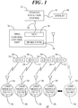
- FIG. 1 shows a block diagram of a system 20 for calibrating output data from a vehicle navigation system 22 in accordance with an embodiment.
- System 20 generally includes vehicle navigation system 22 and a plurality of sensor modules, referred to herein as TPMS modules 24, in radio frequency (RF) communication with a TPMS central control unit 26.
- TPMS modules 24 has a unique identifier 28 and is mounted inside of each wheel (not shown), such as on the rim, valve, or in-tire.
- each TPMS module 24 transmits data packets 30 to central control unit 26.
- Data packets 30 include unique identifier 28 associated with the particular TPMS module 24 and TPMS data 32, examples of which will be described in connection with FIG. 2 .
- FIG. 1 explicitly shows four TPMS modules 24. However, ellipses and one of TPMS modules 24 shown in ghost form indicate that the quantity of TPMS modules 24 coincides with the quantity of wheels on the vehicle.
- TPMS central control unit 26 generally includes an RF receiver 34 for receiving data packets 30 and a microcontroller 36 (MCU) in communication with RF receiver 34.
- MCU microcontroller 36
- TPMS central control unit 26 may be in communication with vehicle navigation system 22 via, for example, a serial link 38.
- data packets 30 are received at RF receiver 34 of TPMS central control unit 26.
- TPMS central control unit 26 interprets TPMS data 32 and communicates a portion of TPMS data 32 (discussed below) and the associated unique identifier 28 to vehicle navigation system 22 via serial link 38.
- TPMS central control unit 26 may include a memory unit, firmware, software, electronic circuitry, and the like for providing control, tire pressure monitoring, and data manipulation that will not be discussed herein for brevity.
- Vehicle navigation system 22 is generally used to find direction in a vehicle.
- Vehicle navigation system 22 can use a satellite navigation device (e.g., a GPS receiver) to get its position data which is then correlated to a position on a road.
- vehicle navigation system 22 can implement a dead-reckoning strategy in which distance data from an inertial sensor system (e.g., gyroscope and accelerometer) can be used for greater reliability, as GPS signal loss and/or multipath can occur due to urban canyons or tunnels.
- an inertial sensor system e.g., gyroscope and accelerometer
- the routing can be calculated. This routing information may be presented to the driver on a display unit 40 interconnected with vehicle navigation system 22 via, for example, a serial link 42.
- the inertial sensors require frequent recalibration.
- the output data from the inertial sensors used for dead-reckoning quickly accumulates velocity and position errors due to drift, noise, and a random-walk drift tendency of the inertial sensor data.
- periodic recalibration of the inertial sensor data based on TPMS data 32 can reduce accumulated position and velocity errors on the inertial sensor output data when operating in a dead-reckoning mode without requiring an available GPS signal.
- FIG. 2 shows a block diagram of one of TPMS modules 24 of system 20 ( FIG. 1 ).
- TPMS module 22 includes a pressure sensor 48, a temperature sensor 50, and an acceleration sensor 52.
- TPMS module 22 additionally includes control circuitry such as, for example, sensor signal pre-processing circuitry 54, a microcontroller 56 (MCU), a memory unit 58, an RF transmitter 60, and a power source 62.
- MCU microcontroller 56
- Pressure sensor 48 is used to monitor the pressure of the tire and periodically produce a pressure signal 64, P.
- Temperature sensor 50 is used to monitor the ambient temperature at the tire and periodically produce a temperature signal 66, T.
- acceleration sensor 52 is a dual axis accelerometer.
- acceleration sensor 52 can be used to detect X-axis acceleration, referred to herein as tangential acceleration, and produce a tangential acceleration signal 68, labeled Ax.
- acceleration sensor 52 can be used to detect Z-axis acceleration, referred to herein as radial acceleration, and produce a radial acceleration signal 70, labeled Az.
- tangential and radial acceleration are measured directly.
- TPMS modules 22 when TPMS modules 22 are implemented as a replacement for the valve stem cap or TPMS modules 22 are affixed to the inside of the tire, the accelerometers will be out-of-plane. That is, tangential and radial accelerations may be suitably computed or processed to obtain tangential and radial signals 68, 70.
- pressure signal 64, temperature signal 66, tangential acceleration signal 68, and radial acceleration signal 70 are received at sensor signal pre-processing circuitry 54 where the signals 64, 66, 68, 70 are suitably processed (e.g., filtered, amplified, digitized, etc.). Thereafter, the processed signals 64, 66, 68, 70 are received at and processed by MCU 56. MCU 56 executes a control algorithm 72 to acquire and interpret signals 64, 66, 68, 70 and to enable transmission of data packets 30.
- a wheel velocity determination algorithm 74 may be executed to determine the velocity of the wheel to which TPMS module is coupled.
- radial acceleration signal 70 may be used to facilitate a determination of the tangential velocity (discussed below) of the wheel.
- the tangential velocity of the wheel can be used to calibrate output data from an inertial sensor system of vehicle navigation system 22 ( FIG. 1 ).
- tangential acceleration signal 68 may be used to facilitate a determination of the angular rotation rate of the wheel to which TPMS module 24 is coupled.
- the angular rotation rate can be used to determine the tangential velocity of the wheel, and the obtained tangential velocity can be used to calibrate the output data from the inertial sensor system of vehicle navigation system 22.
- This calibration methodology will be discussed in greater detail below in connection with FIG. 6 .
- a dual axis acceleration sensor 52 is shown, alternative embodiments may include a single axis acceleration sensor having with Z-axis acceleration detection capability or X-axis acceleration detection capability.
- RF transmitter 60 Periodically, RF transmitter 60, in communication with MCU 56, outputs data packets 30.
- these data packets 30 can include unique identifier 28 for TPMS module 24 and a movement signal 76 indicative of wheel velocity.
- data packets 30 can include pressure signal 64, temperature signal 66, and so forth.
- data packets 30 may include other sensor information detailing, for example, voltage, characteristics of the tire, wheel, and environment, and so forth. This additional sensor information is not discussed in detail herein for brevity.
- acceleration sensor 52 of each respective front-right and back-right wheel 82 may be mounted such that a positive X-axis of acceleration sensor 52 is exposed when vehicle 80 moves in a forward direction.
- acceleration sensor 52 of each respective front left and back left wheel 82 may be mounted such that a negative X-axis of acceleration sensor 52 is exposed when vehicle 80 moves in the forward direction.
- radial acceleration signal 70 ( FIG. 2 ) is common to all locations of TPMS modules 24, assuming that TPMS modules are mechanically identical in construction, with the Z-axis pointing toward axle 84.
- acceleration sensors 52 incorporated in wheels 82 on the right side of vehicle 80 produce tangential acceleration signal 68 ( FIG. 2 ) that is inverse with respect to tangential acceleration signal 68 produced by acceleration sensors 52 incorporated in wheels 82 on the left side of vehicle 80.
- Each TPMS module 24 can assess its rotational dynamics, and in particular tangential acceleration signals 68 and/or radial acceleration signals 70, to determine movement information indicative of the wheel velocity of the wheel to which TPMS 24 is coupled. This movement information can thereafter be transmitted from each TPMS module 24 as movement signal 76 ( FIG. 2 ) in data packets 30 ( FIG. 2 ). Further, TPMS central control unit 26 can forward movement signal 76 and unique identifier 28 ( FIG. 2 ) to vehicle navigation system 22 ( FIG. 1 ), where movement signal 76 can be received and evaluated for calibration of output data (discussed below) determined from motion signals produced by an inertial sensor system of vehicle navigation system 22.
- FIG. 4 shows a block diagram of an example arrangement of vehicle navigation system 22 implemented in vehicle 80.
- vehicle navigation system 22 uses a GPS antenna 86 to receive GPS signals.
- GPS antenna 86 may be connected to a GPS receiver 88.
- GPS receiver 88 can determine geographic position by measuring the ranges (e.g., the distance between a satellite with known coordinates in space and GPS antenna 86) of several satellites and computing the geometric intersection of these ranges.
- GPS receiver 88 provides GPS measurements to a controller unit, referred to herein as a navigation unit 90.
- Navigation unit 90 can include processing circuitry, buses, interface hardware, and related circuitry for performing the location and route finding functions of vehicle navigation system 22.
- a memory element 92 is in communication with processing unit. Memory element 92 can have various algorithms stored therein. In an example, a location system algorithm 94, a route finder algorithm 96, and a calibration system algorithm 98 may be stored in memory element 92.
- a map database 100 may additionally be stored in memory element 92. Map database 100 stores map information, such as a road network, and provides the map information to navigation unit 90.
- a user interface 102 which may include display 40, and a key- or touch-pad 104, and the like, enables interaction between the user and vehicle navigation system 22, such as entry of and tracking to a desired destination.
- vehicle navigation system 22 further includes an inertial sensor system 106 in communication with navigation unit 90.
- Inertial sensor system 106 can include a two or three axis accelerometer 108 that provides motion signals (e.g., acceleration signals) that are indicative of the motion of vehicle 80.
- Inertial sensor system 106 can additionally include a two or three axis gyroscope 110 that also provides motion signals (e.g., angular velocity signals) that are indicative of the motion of vehicle 80.
- Inertial sensor system 106 including accelerometer 108 and gyroscope 110 may be relatively low cost six-degree-of-freedom microelectromechanical systems (MEMS) sensors.
- MEMS microelectromechanical systems
- navigation unit 90 executes location system algorithm 94 to evaluate GPS signals from GPS receiver 88 and/or acceleration signals 112 and angular velocity signals 114 from inertial sensor system 106 to propagate vehicle position and therefore track the position of vehicle 80 on a map.
- Navigation unit 90 further executes route finder algorithm 96 to calculate a route to a destination entered via user interface 102 by a user.
- navigation unit 90 can utilize motion signals (e.g., acceleration signals 112 and angular velocity signals 114) from inertial sensor system 106 to track the position of vehicle 80 using, for example, dead-reckoning methodology in which a current position is calculated by using a previously determined position, or fix, and advancing that positioning based upon known or estimated speeds over elapsed time and course.
- the motion signals from inertial sensor system 106 may be used by navigation unit 90 to determine output data 116 in the form of, for example, a current vehicle velocity 118 (labeled V VEH ), a current vehicle position 120 (labeled P VEH ), and the like if GPS information is not available.
- This output data 116 may be utilized during execution of location system algorithm 94 and/or route finder algorithm 96.
- Circular motion is the movement of an object along the circumference of a circle or rotation along a circular path.
- one of wheels 82 (represented by a dotted circle) undergoes circular motion. Since the velocity vector of wheel 82 is constantly changing direction, wheel 82 is undergoing acceleration by a centripetal force in the direction of the center of rotation. Uniform circular motion describes the motion of a body, e.g., wheel 82, traversing a circular path at constant speed.
- wheel 82 undergoes circular motion, its distance, i.e. radius of rotation 128, from an axis of rotation 130 remains generally constant.
- the wheel velocity e.g., tangential velocity 124, is not constant.
- tangential velocity 124 is a vector quantity that depends both on the speed of wheel 82 and its direction of travel. This changing tangential velocity 124 indicates the presence of an acceleration. This acceleration is referred to as radial acceleration 122, or alternatively, a centripetal acceleration. Radial acceleration 122 is of constant magnitude and is directed at all times towards axis of rotation 130.
- a R is radial (i.e., centripetal) acceleration 122
- V T is tangential velocity 124
- R is a radius of rotation 130
- ⁇ is angular rotation rate 126.
- the wheel velocity referred to herein as tangential velocity 124
- FIG. 6 shows a flow chart of a calibration process 132 in accordance with another embodiment.
- calibration process 132 details the operations performed through the execution of calibration system algorithm 98 by navigation unit 90 of vehicle navigation system 22.
- Calibration process 132 may be performed continuously to calibrate output data 116 determined by navigation unit 90 in response to motion signals (e.g., acceleration signals 112 and angular velocity signals 114) supplied by inertial sensor system 106.
- motion signals e.g., acceleration signals 112 and angular velocity signals 11
- calibration process 132 is executed to calibrate, for example, vehicle velocity 118 and vehicle position 120 utilizing movement signals 76 provided by TPMS modules 24 ( FIG. 2 ).
- Movement signals 76 provide direct information on the actual vehicle velocity and are immune to the problems associated with accelerometer signals 112 from accelerometer 108, such as drift and random-walk.
- vehicle navigation system 22 is initialized.
- System initialization may occur when vehicle 80 ( FIG. 4 ) is first turned on.
- System initialization may entail obtaining an initial position of vehicle 80 ( FIG. 4 ) in response to GPS signals detected at GPS antenna 86. Additionally, or alternatively, system initialization may entail obtaining an initial position of vehicle 80 based on a last known position of vehicle 80.
- the output data 116 (e.g., vehicle velocity 118, V VEH , and vehicle position 120, P VEH ) determined by navigation unit 90 in response to motion signals (e.g., acceleration signals 112 and angular velocity signals 114) is calibrated.
- navigation unit 90 may self-calibrate these values in a known manner. For example, navigation unit 90 may calibrate output data in response to stored information and/or by using factory defaults.
- navigation unit 90 polls or otherwise receives unique identifiers 28 and movement signals 76 from TPMS central control unit 26 ( FIG. 1 ).
- movement signals 76 are indicative of the movement of one of wheels 82 on vehicle 80 that was measured or otherwise detected at TPMS modules 24.
- Movement signals 76 can be radial acceleration 122 ( FIG. 5 ), tangential velocity 124 ( FIG. 5 ), angular rotation rate 126 ( FIG. 5 ), and the like.
- the wheel velocity, V wheel can be determined from movement signals 76. That is, wheel velocity is evaluated based on data from one or more TPMS modules 24 ( FIG. 1 ).
- wheel velocity is evaluated based on data from one or more TPMS modules 24 ( FIG. 1 ).
- this tangential velocity 124 describes the linear motion of wheel 82, i.e., the wheel velocity, V WHEEL .
- the wheel velocity, V WHEEL can be computed in accordance with equation (1) above.
- angular rotation rate 126 is received at navigation unit 90
- the wheel velocity, V WHEEL can also be computed in accordance with equation (1) above.
- wheel position may also be determined from movement signals 76.
- the multiple TPMS modules 24 can obtain, measure, and transmit movement signals 76 characterizing radial acceleration 122, tangential velocity 124 (as the wheel velocity), or angular rotation rate 126 for each individual wheel 82 at a specified sampling interval.
- Navigation unit 90 receives and interprets the movement signal 76. Further, navigation unit 90 can convert tangential velocity 124 data or angular rotation rate 126 data into displacement, S, which can be effectively compared with vehicle position 120, V POS , obtained from acceleration signals 112 and/or angular velocity signals 114 produced by inertial sensor system 106.
- the availability of movement signals 76 from multiple wheels 82 effectively increases the sampling frequency and enables the computation of an averaged movement signal, e.g., an averaged wheel velocity 124 signal. Determination of an averaged wheel velocity 124 can increase robustness and signal-to-noise ratio of the data.
- a block 142 is performed concurrent with blocks 138 and 140.
- vehicle velocity 118, V VEH is determined from the motion signals produced by inertial sensor system 106 of vehicle navigation system 22.
- output data 116 determined from the motion signals produced by inertial sensor system 106 is compared with movement signals 76 from TPMS modules 24.
- vehicle velocity 118, V VEH is compared with the tangential velocity 124 (i.e., the wheel velocity) determined from movement signals 76 provided by TPMS modules 24.
- vehicle position 120, P VEH may be compared with the wheel displacement value determined via equation (3) above.
- a determination is made as to whether output data 116 falls within predetermined error threshold(s) of movement signals 76.
- process control continues with a block 146 where calibration value(s) are computed utilizing tangential velocity 124. Thereafter, process control loops back to block 136 in order to calibrate navigation system output data 116 using the computed values and therefore remove an error component from output data 116. However, when output data 116 falls within the predetermined error threshold, recalibration need not occur. Accordingly, process control loops back to block 138 to continue polling or otherwise receiving movement signals 76, comparing output data 116 with TPMS-provided movement signals 76, and performing recalibration as needed. Accordingly, the loop back processing ensures that output data is continuously recalibrated in order to reduce accumulated velocity and position errors without with using GPS signals.
- Such a calibration technique utilizing TPMS-provided movement signals 76 can be particularly useful in situations when vehicle 80 moves at a constant speed or over rough or inclined terrain where acceleration signals 112 from inertial sensor system 106 are especially prone to error.
- Performing continuous correlation of output data 116 with TPMS-provided movement signals 76 can remove uncertainty and drift so as to maintain high positioning precision.
- inertial sensor system 106 may be utilized for navigating vehicle 80 in the absence of GPS signals. Accordingly, such a technique can be highly advantageous for vehicles in remote areas or under driving conditions in which GPS signals are absent or weak. Further, such a technique may be effectively implemented in slow moving, small robotic vehicles that do not rely on the accuracy provided by GPS signals.
- Such a system would be free of accumulated errors, and could be capable of self-navigating (using map data) for extended distances and time spans.
- An embodiment of a method comprises determining a movement signal at a sensor module coupled with a wheel on a vehicle, receiving, at a vehicle navigation system of the vehicle, the movement signal from the sensor module, wherein the vehicle navigation system includes at least one inertial sensor configured to supply a motion signal indicative of motion of the vehicle, and the vehicle navigation system is configured to determine output data in response to the motion signal, and calibrating, at the vehicle navigation system, the output data by utilizing the movement signal to remove an error component from the output data.
- An embodiment of a system comprises a sensor module coupled with a wheel on a vehicle, the sensor module being configured to determine a movement signal for the wheel, and a vehicle navigation system of the vehicle.
- the vehicle navigation system includes at least one inertial sensor configured to supply a motion signal indicative of motion of the vehicle, and a controller unit in communication with the at least one inertial sensor, the controller unit being configured to receive the motion signal from the at least one inertial sensor and determine output data in response to the motion signal, and the controller unit being further configured to receive the movement signal from the sensor module and calibrate the output data by utilizing the movement signal to remove an error component from the output data.
- An embodiment of a method of providing accurate inertial navigation data in a vehicle comprises determining the inertial navigation data at a vehicle navigation system within the vehicle, the vehicle navigation system including at least one inertial sensor configured to supply a motion signal indicative of motion of the vehicle and a controller in communication with the at least one inertial sensor, the controller unit being configured to receive the motion signal from the at least one inertial sensor and determine the inertial navigation data in response to the motion signal, receiving, at the vehicle navigation system of the vehicle, a movement signal from a tire pressure monitoring system (TPMS) module coupled with a wheel on the vehicle, the movement signal being indicative of a tangential velocity of the wheel, and calibrating, at the vehicle navigation system, the inertial navigation data by utilizing the movement signal to remove an error component from the inertial navigation data.
- TPMS tire pressure monitoring system
- the system and methodology utilize detected movement signals from one or more tire pressure monitoring system (TPMS) modules in order to verify and calibrate vehicle velocity and vehicle position data output from an inertial sensor system of the vehicle navigation system.
- the detected movement signals can be the wheel velocity or the angular rotation rate of the wheel.
- the movement signals produced by the TPMS modules can provide a reliable estimate of the actual vehicle velocity and the distance traveled even when the vehicle moves in a straight line with near-zero acceleration or when the vehicle travels over rough and inclined terrain in which the inertial sensor system accelerometer readings would typically become unreliable.
Landscapes
- Engineering & Computer Science (AREA)
- Radar, Positioning & Navigation (AREA)
- Remote Sensing (AREA)
- Physics & Mathematics (AREA)
- General Physics & Mathematics (AREA)
- Automation & Control Theory (AREA)
- Mechanical Engineering (AREA)
- Manufacturing & Machinery (AREA)
- Navigation (AREA)
Abstract
Description
- The present invention relates generally to vehicle navigation systems for wheeled vehicles. More specifically, the present invention relates to the use of tire pressure monitoring system (TPMS) signals for calibration of inertial navigation data.
- Vehicle navigation systems based on global positioning system (GPS) receivers have become pervasive in both business and recreational vehicles. Such vehicle navigation systems do not work well, however, when signals from GPS satellites are obscured or unavailable as may happen when driving in a parking garage or tunnel, in urban canyons, and/or near trees due to blocked lines of sight to the satellites or due to multipath propagation.
- Accordingly, dead-reckoning is increasingly being implemented in vehicle navigation systems in order to overcome the problems associated with GPS technology alone. In navigation, dead-reckoning is the process of calculating a current position by using a previously determined position, or fix, and advancing that positioning based upon known or estimated speeds over elapsed time and course.
- In a vehicle navigation system that uses dead-reckoning, the vehicle is equipped with inertial sensors (e.g., accelerometers and gyroscopes) that know the velocity and direction of travel of the vehicle. Accordingly, such a vehicle navigation system that uses dead-reckoning can be implemented as a supplement to or in lieu of a GPS-based vehicle navigation system. For example, a vehicle navigation system may use a Kalman filter to integrate the always-available sensor data with the accurate but occasionally unavailable GPS position information into a combined fixed position. Alternatively, a vehicle navigation system that uses dead-reckoning can provide navigation data in the event of GPS signal loss.
- The sensors used for dead-reckoning typically require recalibration based on GPS velocity and position information. Indeed, in the absence of recalibration signals, a vehicle navigation system that uses dead-reckoning quickly accumulates velocity and position errors due to drift, noise, and a random-walk drift tendency of the accelerometer data that are at levels unacceptable for the purpose of vehicle navigation. Accordingly, periodic recalibration based on GPS data can reduce accumulated position and velocity errors when operating in a dead-reckoning mode utilizing the supplemental inertial sensor measurement system. However, continuous recalibration of the vehicle inertial navigation data based on the GPS data requires sufficient frequency of such recalibration events and, as such, requires high availability of the GPS signal.
- The accompanying figures in which like reference numerals refer to identical or functionally similar elements throughout the separate views, the figures are not necessarily drawn to scale, and which together with the detailed description below are incorporated in and form part of the specification, serve to further illustrate various embodiments and to explain various principles and advantages all in accordance with the present invention.
-
FIG. 1 shows a block diagram of a system for calibrating output data from a vehicle navigation system in accordance with an embodiment; -
FIG. 2 shows a block diagram of a tire pressure sensor system (TPMS) module of the system ofFIG. 1 ; -
FIG. 3 shows a block diagram of a TPMS system that includes a plurality of TPMS modules implemented in a vehicle; -
FIG. 4 shows a block diagram of an example arrangement of a vehicle navigation system implemented in the vehicle ofFIG. 3 ; -
FIG. 5 shows diagram exemplifying a relationship between radial acceleration and tangential velocity in a rotating object; and -
FIG. 6 shows a flowchart of a calibration process in accordance with another embodiment. - In overview, embodiments disclosed herein entail a system and methodology for calibrating inertial navigation data of a vehicle navigation system using tire pressure monitoring system signals. More particularly, the system and methodology utilizes detected movement signals from one or more tire pressure monitoring system (TPMS) modules in order to verify and calibrate vehicle velocity and vehicle position data output from an inertial sensor system of the vehicle navigation system. The detected movement signals can be radial acceleration, wheel velocity, or rotation rate of the wheel. The movement signals produced by the TPMS modules can provide a reliable estimate of the actual vehicle velocity and the distance traveled even when the vehicle moves in a straight line with near-zero acceleration or when the vehicle travels over rough and inclined terrain in which the inertial sensor system accelerometer readings would typically become unreliable. Further, by utilizing the movement signals from the TPMS modules to calibrate data output from the inertial sensor system of the vehicle navigation system, the requirement for recalibration utilizing global positioning system (GPS) signals is minimized or eliminated. Accordingly, recalibration can occur continuously, even in the absence of GPS signals
- The instant disclosure is provided to further explain in an enabling fashion the best modes, at the time of the application, of making and using various embodiments in accordance with the present invention. The disclosure is further offered to enhance an understanding and appreciation for the inventive principles and advantages thereof, rather than to limit in any manner the invention. The invention is defined solely by the appended claims including any amendments made during the pendency of this application and all equivalents of those claims as issued.
- It should be further understood that the use of relational terms, if any, such as first and second, top and bottom, and the like are used solely to distinguish one from another entity or action without necessarily requiring or implying any actual such relationship or order between such entities or actions.
- Referring to
FIG. 1, FIG. 1 shows a block diagram of asystem 20 for calibrating output data from avehicle navigation system 22 in accordance with an embodiment.System 20 generally includesvehicle navigation system 22 and a plurality of sensor modules, referred to herein asTPMS modules 24, in radio frequency (RF) communication with a TPMScentral control unit 26. EachTPMS module 24 has aunique identifier 28 and is mounted inside of each wheel (not shown), such as on the rim, valve, or in-tire. As will be discussed below, eachTPMS module 24 transmitsdata packets 30 tocentral control unit 26.Data packets 30 includeunique identifier 28 associated with theparticular TPMS module 24 andTPMS data 32, examples of which will be described in connection withFIG. 2 .FIG. 1 explicitly shows fourTPMS modules 24. However, ellipses and one ofTPMS modules 24 shown in ghost form indicate that the quantity ofTPMS modules 24 coincides with the quantity of wheels on the vehicle. - TPMS
central control unit 26 generally includes anRF receiver 34 for receivingdata packets 30 and a microcontroller 36 (MCU) in communication withRF receiver 34. In accordance with an embodiment, TPMScentral control unit 26 may be in communication withvehicle navigation system 22 via, for example, aserial link 38. In general,data packets 30 are received atRF receiver 34 of TPMScentral control unit 26. Thereafter, TPMScentral control unit 26 interpretsTPMS data 32 and communicates a portion of TPMS data 32 (discussed below) and the associatedunique identifier 28 tovehicle navigation system 22 viaserial link 38. Additionally, TPMScentral control unit 26 may include a memory unit, firmware, software, electronic circuitry, and the like for providing control, tire pressure monitoring, and data manipulation that will not be discussed herein for brevity. -
Vehicle navigation system 22 is generally used to find direction in a vehicle.Vehicle navigation system 22 can use a satellite navigation device (e.g., a GPS receiver) to get its position data which is then correlated to a position on a road. Additionally, or alternatively,vehicle navigation system 22 can implement a dead-reckoning strategy in which distance data from an inertial sensor system (e.g., gyroscope and accelerometer) can be used for greater reliability, as GPS signal loss and/or multipath can occur due to urban canyons or tunnels. When directions are needed, the routing can be calculated. This routing information may be presented to the driver on adisplay unit 40 interconnected withvehicle navigation system 22 via, for example, a serial link 42. - In a vehicle navigation system that employs inertial sensors to perform dead-reckoning, such as
vehicle navigation system 22, the inertial sensors require frequent recalibration. In particular, the output data from the inertial sensors used for dead-reckoning quickly accumulates velocity and position errors due to drift, noise, and a random-walk drift tendency of the inertial sensor data. In accordance with an embodiment, periodic recalibration of the inertial sensor data based on TPMS data 32 (described below) can reduce accumulated position and velocity errors on the inertial sensor output data when operating in a dead-reckoning mode without requiring an available GPS signal. -
FIG. 2 shows a block diagram of one ofTPMS modules 24 of system 20 (FIG. 1 ).TPMS module 22 includes apressure sensor 48, atemperature sensor 50, and anacceleration sensor 52.TPMS module 22 additionally includes control circuitry such as, for example, sensor signal pre-processingcircuitry 54, a microcontroller 56 (MCU), amemory unit 58, anRF transmitter 60, and apower source 62. -
Pressure sensor 48 is used to monitor the pressure of the tire and periodically produce apressure signal 64,P. Temperature sensor 50 is used to monitor the ambient temperature at the tire and periodically produce atemperature signal 66, T. In an embodiment,acceleration sensor 52 is a dual axis accelerometer. Thus,acceleration sensor 52 can be used to detect X-axis acceleration, referred to herein as tangential acceleration, and produce atangential acceleration signal 68, labeled Ax. Additionally,acceleration sensor 52 can be used to detect Z-axis acceleration, referred to herein as radial acceleration, and produce aradial acceleration signal 70, labeled Az. In some embodiments, tangential and radial acceleration are measured directly. In other configurations, for example, whenTPMS modules 22 are implemented as a replacement for the valve stem cap orTPMS modules 22 are affixed to the inside of the tire, the accelerometers will be out-of-plane. That is, tangential and radial accelerations may be suitably computed or processed to obtain tangential andradial signals - In general,
pressure signal 64,temperature signal 66,tangential acceleration signal 68, andradial acceleration signal 70 are received at sensor signal pre-processingcircuitry 54 where thesignals MCU 56.MCU 56 executes acontrol algorithm 72 to acquire and interpretsignals data packets 30. - Through the execution of
control algorithm 72, a wheelvelocity determination algorithm 74 may be executed to determine the velocity of the wheel to which TPMS module is coupled. By way of example,radial acceleration signal 70 may be used to facilitate a determination of the tangential velocity (discussed below) of the wheel. The tangential velocity of the wheel can be used to calibrate output data from an inertial sensor system of vehicle navigation system 22 (FIG. 1 ). Alternatively or additionally,tangential acceleration signal 68 may be used to facilitate a determination of the angular rotation rate of the wheel to whichTPMS module 24 is coupled. Thereafter, the angular rotation rate can be used to determine the tangential velocity of the wheel, and the obtained tangential velocity can be used to calibrate the output data from the inertial sensor system ofvehicle navigation system 22. This calibration methodology will be discussed in greater detail below in connection withFIG. 6 . Thus, although a dualaxis acceleration sensor 52 is shown, alternative embodiments may include a single axis acceleration sensor having with Z-axis acceleration detection capability or X-axis acceleration detection capability. - Periodically,
RF transmitter 60, in communication withMCU 56,outputs data packets 30. In response to the execution ofcontrol algorithm 72, and the associated wheelvelocity determination algorithm 74, thesedata packets 30 can includeunique identifier 28 forTPMS module 24 and amovement signal 76 indicative of wheel velocity. Additionally,data packets 30 can includepressure signal 64,temperature signal 66, and so forth. Those skilled in the art will recognize thatdata packets 30 may include other sensor information detailing, for example, voltage, characteristics of the tire, wheel, and environment, and so forth. This additional sensor information is not discussed in detail herein for brevity. -
FIG. 3 shows a block diagram of a tire pressure monitoring system (TPMS) 78 that includes a plurality ofTPMS modules 24 and TPMScentral control unit 26 implemented in avehicle 80. In particular,individual wheels 82 are mounted tovehicle 80 via anaxle 84, and one each ofTPMS modules 24 is associated with one each ofwheels 82 ofvehicle 80. TPMScentral control unit 26 is located at any suitable location withinvehicle 80.Acceleration sensor 52 of eachrespective wheel 82 is suitably mounted to providetangential acceleration signal 68 and/or radial acceleration signal 70 (FIG. 2 ) in response to the motion ofvehicle 80. - In an example,
acceleration sensor 52 of each respective front-right and back-right wheel 82 may be mounted such that a positive X-axis ofacceleration sensor 52 is exposed whenvehicle 80 moves in a forward direction. Conversely,acceleration sensor 52 of each respective front left and back leftwheel 82 may be mounted such that a negative X-axis ofacceleration sensor 52 is exposed whenvehicle 80 moves in the forward direction. - Accordingly, radial acceleration signal 70 (
FIG. 2 ) is common to all locations ofTPMS modules 24, assuming that TPMS modules are mechanically identical in construction, with the Z-axis pointing towardaxle 84. However,acceleration sensors 52 incorporated inwheels 82 on the right side ofvehicle 80 produce tangential acceleration signal 68 (FIG. 2 ) that is inverse with respect totangential acceleration signal 68 produced byacceleration sensors 52 incorporated inwheels 82 on the left side ofvehicle 80. - Each
TPMS module 24 can assess its rotational dynamics, and in particular tangential acceleration signals 68 and/or radial acceleration signals 70, to determine movement information indicative of the wheel velocity of the wheel to whichTPMS 24 is coupled. This movement information can thereafter be transmitted from eachTPMS module 24 as movement signal 76 (FIG. 2 ) in data packets 30 (FIG. 2 ). Further, TPMScentral control unit 26 can forwardmovement signal 76 and unique identifier 28 (FIG. 2 ) to vehicle navigation system 22 (FIG. 1 ), where movement signal 76 can be received and evaluated for calibration of output data (discussed below) determined from motion signals produced by an inertial sensor system ofvehicle navigation system 22. -
FIG. 4 shows a block diagram of an example arrangement ofvehicle navigation system 22 implemented invehicle 80. In this example,vehicle navigation system 22 uses aGPS antenna 86 to receive GPS signals.GPS antenna 86 may be connected to aGPS receiver 88. As known to those skilled in the art,GPS receiver 88 can determine geographic position by measuring the ranges (e.g., the distance between a satellite with known coordinates in space and GPS antenna 86) of several satellites and computing the geometric intersection of these ranges.GPS receiver 88 provides GPS measurements to a controller unit, referred to herein as anavigation unit 90. -
Navigation unit 90 can include processing circuitry, buses, interface hardware, and related circuitry for performing the location and route finding functions ofvehicle navigation system 22. Amemory element 92 is in communication with processing unit.Memory element 92 can have various algorithms stored therein. In an example, alocation system algorithm 94, aroute finder algorithm 96, and acalibration system algorithm 98 may be stored inmemory element 92. Amap database 100 may additionally be stored inmemory element 92.Map database 100 stores map information, such as a road network, and provides the map information tonavigation unit 90. Auser interface 102, which may includedisplay 40, and a key- or touch-pad 104, and the like, enables interaction between the user andvehicle navigation system 22, such as entry of and tracking to a desired destination. - In an accordance with an embodiment,
vehicle navigation system 22 further includes aninertial sensor system 106 in communication withnavigation unit 90.Inertial sensor system 106 can include a two or threeaxis accelerometer 108 that provides motion signals (e.g., acceleration signals) that are indicative of the motion ofvehicle 80.Inertial sensor system 106 can additionally include a two or threeaxis gyroscope 110 that also provides motion signals (e.g., angular velocity signals) that are indicative of the motion ofvehicle 80.Inertial sensor system 106 includingaccelerometer 108 andgyroscope 110 may be relatively low cost six-degree-of-freedom microelectromechanical systems (MEMS) sensors. For simplicity of illustration, the acceleration signals fromaccelerometer 108 are generally referred to as acceleration signals 112, and are labeled Ax, AY, AZ inFIG. 4 . Similarly, angular velocity signals fromgyroscope 112 are generally referred to as angular velocity signals 114, and are labeled ωX, ωY, ωZ inFIG. 4 . Accordingly,navigation unit 90 can collect and monitor vehicle acceleration signals 112 and angular velocity signals 114 in order to determine, for example vehicle velocity, attitude and position for use as inertial navigation data. - In general,
navigation unit 90 executeslocation system algorithm 94 to evaluate GPS signals fromGPS receiver 88 and/or acceleration signals 112 and angular velocity signals 114 frominertial sensor system 106 to propagate vehicle position and therefore track the position ofvehicle 80 on a map.Navigation unit 90 further executesroute finder algorithm 96 to calculate a route to a destination entered viauser interface 102 by a user. - In an embodiment, when GPS signals are unavailable,
navigation unit 90 can utilize motion signals (e.g., acceleration signals 112 and angular velocity signals 114) frominertial sensor system 106 to track the position ofvehicle 80 using, for example, dead-reckoning methodology in which a current position is calculated by using a previously determined position, or fix, and advancing that positioning based upon known or estimated speeds over elapsed time and course. Thus, the motion signals frominertial sensor system 106 may be used bynavigation unit 90 to determineoutput data 116 in the form of, for example, a current vehicle velocity 118 (labeled VVEH), a current vehicle position 120 (labeled PVEH), and the like if GPS information is not available. Thisoutput data 116 may be utilized during execution oflocation system algorithm 94 and/orroute finder algorithm 96. - As discussed above, sensor errors accumulate rapidly and positioning accuracy degrades quickly when relying on
inertial sensor system 106 to determine current vehicle velocity andposition output data 116 is therefore performed through the execution ofcalibration system algorithm 98. In particular,navigation unit 90 calibratesoutput data 116 by utilizingmovement signal 76 from one ormore TPMS modules 24 to remove an error component fromoutput data 116. Thus, continuous recalibration ofnavigation output data 116 can be performed even in the absence of GPS signals. Further,movement signal 76 provides a reliable estimate of vehicle velocity and distance travelled even whenvehicle 80 moves in a straight-line with near-zero acceleration or over rough and inclined terrain. -
FIG. 5 shows diagram exemplifying a relationship betweenradial acceleration 122, labeled AR, andtangential velocity 124, labeled VT, in a rotating object. Further,FIG. 5 showstangential velocity 124 andradial acceleration 122 in uniform circular motion, anangular rotation rate 126, labeled ω, and a radius ofrotation 128, labeled R, in which radius ofrotation 128 is the known radius of the rotating body. This relationship is exploited within the calibration methodology in order to utilize movement signal 76 (FIG. 2 ) in the calibration of output data 116 (FIG. 4 ) and thereby remove an error component fromoutput data 116. - Circular motion is the movement of an object along the circumference of a circle or rotation along a circular path. Of course, one of wheels 82 (represented by a dotted circle) undergoes circular motion. Since the velocity vector of
wheel 82 is constantly changing direction,wheel 82 is undergoing acceleration by a centripetal force in the direction of the center of rotation. Uniform circular motion describes the motion of a body, e.g.,wheel 82, traversing a circular path at constant speed. Whenwheel 82 undergoes circular motion, its distance, i.e. radius ofrotation 128, from an axis ofrotation 130 remains generally constant. The wheel velocity, e.g.,tangential velocity 124, is not constant. Rather,tangential velocity 124 is a vector quantity that depends both on the speed ofwheel 82 and its direction of travel. This changingtangential velocity 124 indicates the presence of an acceleration. This acceleration is referred to asradial acceleration 122, or alternatively, a centripetal acceleration.Radial acceleration 122 is of constant magnitude and is directed at all times towards axis ofrotation 130. - The acceleration, i.e.,
radial acceleration 122, due to change in the direction can be characterized by an equation presented inFIG. 5 , and is repeated herein as follows:
- In equation (1), AR, is radial (i.e., centripetal)
acceleration 122, VT istangential velocity 124, R is a radius ofrotation 130, and ω isangular rotation rate 126. In some embodiments, the wheel velocity, referred to herein astangential velocity 124, can readily be determined from eitherradial acceleration 122 detected by acceleration sensor asacceleration signal 70, labeled Az (FIG. 2 ) or angularrotation rate signal 126. - Referring now to
FIGs. 4 and6, FIG. 6 shows a flow chart of acalibration process 132 in accordance with another embodiment. In an example,calibration process 132 details the operations performed through the execution ofcalibration system algorithm 98 bynavigation unit 90 ofvehicle navigation system 22.Calibration process 132 may be performed continuously to calibrateoutput data 116 determined bynavigation unit 90 in response to motion signals (e.g., acceleration signals 112 and angular velocity signals 114) supplied byinertial sensor system 106. In particular, at a specified sampling interval,calibration process 132 is executed to calibrate, for example,vehicle velocity 118 andvehicle position 120 utilizing movement signals 76 provided by TPMS modules 24 (FIG. 2 ). Movement signals 76 provide direct information on the actual vehicle velocity and are immune to the problems associated withaccelerometer signals 112 fromaccelerometer 108, such as drift and random-walk. - At a
block 134,vehicle navigation system 22 is initialized. System initialization may occur when vehicle 80 (FIG. 4 ) is first turned on. System initialization may entail obtaining an initial position of vehicle 80 (FIG. 4 ) in response to GPS signals detected atGPS antenna 86. Additionally, or alternatively, system initialization may entail obtaining an initial position ofvehicle 80 based on a last known position ofvehicle 80. - At a
block 136, the output data 116 (e.g.,vehicle velocity 118, VVEH, andvehicle position 120, PVEH) determined bynavigation unit 90 in response to motion signals (e.g., acceleration signals 112 and angular velocity signals 114) is calibrated. At an initial execution ofblock 136 whenvehicle navigation system 22 is initialized,navigation unit 90 may self-calibrate these values in a known manner. For example,navigation unit 90 may calibrate output data in response to stored information and/or by using factory defaults. - At a
block 138,navigation unit 90 polls or otherwise receivesunique identifiers 28 and movement signals 76 from TPMS central control unit 26 (FIG. 1 ). Of course, movement signals 76 are indicative of the movement of one ofwheels 82 onvehicle 80 that was measured or otherwise detected atTPMS modules 24. Movement signals 76 can be radial acceleration 122 (FIG. 5 ), tangential velocity 124 (FIG. 5 ), angular rotation rate 126 (FIG. 5 ), and the like. - At a
block 140, the wheel velocity, Vwheel, can be determined from movement signals 76. That is, wheel velocity is evaluated based on data from one or more TPMS modules 24 (FIG. 1 ). By way of example, whentangential velocity 124 is receivednavigation unit 90, thistangential velocity 124 describes the linear motion ofwheel 82, i.e., the wheel velocity, VWHEEL. Alternatively, whenradial acceleration 122 is received atnavigation unit 90, the wheel velocity, VWHEEL, can be computed in accordance with equation (1) above. Likewise, whenangular rotation rate 126 is received atnavigation unit 90, the wheel velocity, VWHEEL, can also be computed in accordance with equation (1) above. Alternatively, the wheel velocity, VWHEEL, can be obtained fromangular rotation rate 126 as:
- Further, the following equation characterizes the determination of wheel displacement, i.e., wheel position, from movement signals 76:

- In equation (3), S is the travelled path, R is radius of rotation 128 (the wheel radius), ω is
angular rotation rate 126, and Δt is the sampling interval. Accordingly, wheel position may also be determined from movement signals 76. - In some embodiments, the change in velocity (ΔV) from the average change in velocity (ΔVAVG) can be monitored for each
wheel 82. This value is directly proportional to the deviation (ΔR) of the radius ofwheel 82 from average radius of wheel 82 (ΔRAVG). If this value changes,navigation unit 90 could also be alerted to changes in vehicle driving attitude. - Thus, in accordance with
blocks FIG. 2 ) can obtain, measure, and transmit movement signals 76 characterizingradial acceleration 122, tangential velocity 124 (as the wheel velocity), orangular rotation rate 126 for eachindividual wheel 82 at a specified sampling interval.Navigation unit 90 receives and interprets themovement signal 76. Further,navigation unit 90 can converttangential velocity 124 data orangular rotation rate 126 data into displacement, S, which can be effectively compared withvehicle position 120, VPOS, obtained fromacceleration signals 112 and/or angular velocity signals 114 produced byinertial sensor system 106. - The availability of movement signals 76 from multiple wheels 82 (e.g., four or more wheels 82) effectively increases the sampling frequency and enables the computation of an averaged movement signal, e.g., an averaged
wheel velocity 124 signal. Determination of an averagedwheel velocity 124 can increase robustness and signal-to-noise ratio of the data. - A
block 142 is performed concurrent withblocks block 142,vehicle velocity 118, VVEH, is determined from the motion signals produced byinertial sensor system 106 ofvehicle navigation system 22. - At a
query block 144,output data 116 determined from the motion signals produced byinertial sensor system 106 is compared with movement signals 76 fromTPMS modules 24. For example,vehicle velocity 118, VVEH, is compared with the tangential velocity 124 (i.e., the wheel velocity) determined from movement signals 76 provided byTPMS modules 24. Additionally,vehicle position 120, PVEH, may be compared with the wheel displacement value determined via equation (3) above. Atquery block 144, a determination is made as to whetheroutput data 116 falls within predetermined error threshold(s) of movement signals 76. - When
output data 116 does not fall within a predetermined error threshold(s), process control continues with ablock 146 where calibration value(s) are computed utilizingtangential velocity 124. Thereafter, process control loops back to block 136 in order to calibrate navigationsystem output data 116 using the computed values and therefore remove an error component fromoutput data 116. However, whenoutput data 116 falls within the predetermined error threshold, recalibration need not occur. Accordingly, process control loops back to block 138 to continue polling or otherwise receiving movement signals 76, comparingoutput data 116 with TPMS-provided movement signals 76, and performing recalibration as needed. Accordingly, the loop back processing ensures that output data is continuously recalibrated in order to reduce accumulated velocity and position errors without with using GPS signals. - Such a calibration technique utilizing TPMS-provided movement signals 76 can be particularly useful in situations when
vehicle 80 moves at a constant speed or over rough or inclined terrain where acceleration signals 112 frominertial sensor system 106 are especially prone to error. Performing continuous correlation ofoutput data 116 with TPMS-provided movement signals 76 can remove uncertainty and drift so as to maintain high positioning precision. Due to the high positioning precision that may be obtained,inertial sensor system 106 may be utilized for navigatingvehicle 80 in the absence of GPS signals. Accordingly, such a technique can be highly advantageous for vehicles in remote areas or under driving conditions in which GPS signals are absent or weak. Further, such a technique may be effectively implemented in slow moving, small robotic vehicles that do not rely on the accuracy provided by GPS signals. Such a system would be free of accumulated errors, and could be capable of self-navigating (using map data) for extended distances and time spans. - It is to be understood that certain ones of the process blocks depicted in
FIG. 6 may be performed in parallel with each other or with performing other processes. In addition, it is to be understood that the particular ordering of the process blocks depicted inFIG. 6 may be modified, while achieving substantially the same result. Accordingly, such modifications are intended to be included within the scope of the inventive subject matter. - Thus, a system and methodology for calibrating inertial navigation data of a vehicle navigation system using tire pressure monitoring system signals are disclosed herein. An embodiment of a method comprises determining a movement signal at a sensor module coupled with a wheel on a vehicle, receiving, at a vehicle navigation system of the vehicle, the movement signal from the sensor module, wherein the vehicle navigation system includes at least one inertial sensor configured to supply a motion signal indicative of motion of the vehicle, and the vehicle navigation system is configured to determine output data in response to the motion signal, and calibrating, at the vehicle navigation system, the output data by utilizing the movement signal to remove an error component from the output data.
- An embodiment of a system comprises a sensor module coupled with a wheel on a vehicle, the sensor module being configured to determine a movement signal for the wheel, and a vehicle navigation system of the vehicle. The vehicle navigation system includes at least one inertial sensor configured to supply a motion signal indicative of motion of the vehicle, and a controller unit in communication with the at least one inertial sensor, the controller unit being configured to receive the motion signal from the at least one inertial sensor and determine output data in response to the motion signal, and the controller unit being further configured to receive the movement signal from the sensor module and calibrate the output data by utilizing the movement signal to remove an error component from the output data.
- An embodiment of a method of providing accurate inertial navigation data in a vehicle comprises determining the inertial navigation data at a vehicle navigation system within the vehicle, the vehicle navigation system including at least one inertial sensor configured to supply a motion signal indicative of motion of the vehicle and a controller in communication with the at least one inertial sensor, the controller unit being configured to receive the motion signal from the at least one inertial sensor and determine the inertial navigation data in response to the motion signal, receiving, at the vehicle navigation system of the vehicle, a movement signal from a tire pressure monitoring system (TPMS) module coupled with a wheel on the vehicle, the movement signal being indicative of a tangential velocity of the wheel, and calibrating, at the vehicle navigation system, the inertial navigation data by utilizing the movement signal to remove an error component from the inertial navigation data.
- Accordingly, the system and methodology utilize detected movement signals from one or more tire pressure monitoring system (TPMS) modules in order to verify and calibrate vehicle velocity and vehicle position data output from an inertial sensor system of the vehicle navigation system. The detected movement signals can be the wheel velocity or the angular rotation rate of the wheel. The movement signals produced by the TPMS modules can provide a reliable estimate of the actual vehicle velocity and the distance traveled even when the vehicle moves in a straight line with near-zero acceleration or when the vehicle travels over rough and inclined terrain in which the inertial sensor system accelerometer readings would typically become unreliable. Further, by utilizing the movement signals from the TPMS modules to calibrate data output from the inertial sensor system of the vehicle navigation system the requirement for recalibration utilizing global positioning system (GPS) signals is minimized or eliminated. Accordingly, recalibration can occur continuously, even in the absence of GPS signals
Claims (15)
- A method for calibration of navigation data, the method comprises
determining a movement signal (76) at a sensor module (24) coupled with a wheel (82) on a vehicle (80);
receiving, at a vehicle navigation system (22) of said vehicle (80), said movement signal (76) from said sensor module (24), wherein said vehicle navigation system (22) includes at least one inertial sensor (106) configured to supply a motion signal (112) indicative of motion of said vehicle (80), and said vehicle navigation system (22) is configured to determine output data (116) in response to said motion signal (112); and
calibrating, at said vehicle navigation system (22), said output (116) data by utilizing said movement signal (76) to remove an error component from said output data (116). - The method of claim 1, wherein said sensor module (24) includes at least one accelerometer (108) configured to detect radial acceleration of said wheel (82), and said determining comprises computing said movement signal (76) as a tangential velocity of said wheel from said radial acceleration.
- The method of claim 1 or 2, wherein said movement signal (76) characterizes a wheel velocity (124) of said wheel (82), said output data (116) includes a vehicle velocity (118), and said calibrating comprises correcting said vehicle velocity (118) in response to a difference between said wheel velocity (124) and said vehicle velocity (118).
- The method of any preceding claim, wherein said movement signal (76) characterizes a wheel velocity (124) of said wheel (82), said output data (116) includes a vehicle position, and said calibrating comprises deriving a wheel position in response to said wheel velocity (118) and correcting said vehicle position in response to a difference between said wheel position and said vehicle position.
- The method of any preceding claim, wherein said movement signal (76) characterizes a rotation rate (126) of said wheel (82), said output data (116) includes a vehicle velocity (118), and said calibrating comprises computing a wheel velocity (118) of said wheel (82) from said rotation rate (126) and correcting said vehicle velocity (118) in response to a difference between said wheel velocity (118) and said vehicle velocity (118).
- The method of any preceding claim, wherein said vehicle (80) includes a plurality of wheels (82), one each of said wheels (82) being associated with one each of a plurality of sensor modules (24), wherein said determining is performed at each of said sensor modules (24); said receiving includes receiving said movement signal (76) at said vehicle navigation system (22) from said each of said sensor modules (24); and said calibrating comprises determining an average movement signal value from said movement signal (76) received from said each of said sensor modules (24) and utilizing said average movement signal to calibrate said output data (116).
- The method of any preceding claim, wherein said sensor module (24) comprises a tire pressure monitoring system (TPMS) module associated with said wheel (82), said TPMS module having a unique identifier (28), and said receiving includes receiving said unique identifier (28) with said movement signal (76).
- The method of any preceding claim, further comprising periodically performing said determining, receiving, and utilizing operations.
- The method of any preceding claim, wherein said vehicle navigation system (22) includes a receiver for receiving (88) signals from a satellite-based navigation system, and said calibrating is performed in lieu of utilizing said satellite-based navigation system for calibration of said output data (116).
- A system for calibration of navigation data, the system comprises a sensor module (24) coupled with a wheel (82) on a vehicle (80), said sensor module (24) being configured to determine a movement signal (76) for said wheel (82); and
a vehicle navigation system (22) of said vehicle (80), said vehicle navigation system (22) comprises
at least one inertial sensor (106) configured to supply a motion signal (112) indicative of motion of said vehicle (82); and
a controller unit in communication with said at least one inertial sensor (106), said controller unit being configured to receive said motion signal (112) from said at least one inertial sensor (106) and determine output data (116) in response to said motion signal (112), and said controller unit being further configured to receive said movement signal (76) from said sensor module (24) and calibrate said output data (116) by utilizing said movement signal to remove an error component from said output data (116). - The system of claim 10 wherein said sensor module (24) comprises a tire pressure monitoring system (TPMS) associated with said wheel (82).
- The system of claim 10 or 11, wherein said sensor module (24) includes an accelerometer (52) configured to detect radial acceleration of said wheel (82), and one of said controller unit and said sensor module (24) computes said movement signal (76) as a tangential velocity of said wheel (82) from said radial acceleration.
- The system of any of the preceding claims 10 to 12, wherein said movement signal (76) characterizes a wheel velocity (124) of said wheel (82), said controller unit is configured to determine a vehicle velocity (118) in response to said motion signal (112), said output data (116) including said vehicle velocity (118), and said controller unit corrects said vehicle velocity (118) in response to a difference between said wheel velocity (124) and said vehicle velocity (118).
- The system of any preceding claim, wherein said movement signal (76) characterizes a wheel velocity (124) of said wheel (82), said controller unit is configured to determine a vehicle position in response to said motion signal (124), said output data (116) including said vehicle position, and said controller unit is further configured to derive a wheel position in response to said wheel velocity (124) and correct said vehicle position in response to a difference between said wheel position and said vehicle position.
- The system of any preceding claim further comprising:a plurality of sensor modules (24), one each of said sensor modules (24) being coupled with one each of a plurality of wheels (82) on a vehicle (80), and each of said sensor modules (24) being configured to determine said movement signal (76) for its associated wheel (82); andsaid controller unit is configured to receive said movement signal (76) from said each of said sensor modules (24), determine an average movement signal value from said movement signal (76) received from said each of said sensor modules (24), and utilize said average movement signal to calibrate said output data.
Applications Claiming Priority (1)
| Application Number | Priority Date | Filing Date | Title |
|---|---|---|---|
| US15/276,629 US10077982B2 (en) | 2016-09-26 | 2016-09-26 | Calibrating inertial navigation data using tire pressure monitoring system signals |
Publications (1)
| Publication Number | Publication Date |
|---|---|
| EP3299765A1 true EP3299765A1 (en) | 2018-03-28 |
Family
ID=59846480
Family Applications (1)
| Application Number | Title | Priority Date | Filing Date |
|---|---|---|---|
| EP17190347.9A Withdrawn EP3299765A1 (en) | 2016-09-26 | 2017-09-11 | Calibrating inertial navigation data using tire pressure monitoring system signals |
Country Status (3)
| Country | Link |
|---|---|
| US (1) | US10077982B2 (en) |
| EP (1) | EP3299765A1 (en) |
| CN (1) | CN107869998A (en) |
Cited By (2)
| Publication number | Priority date | Publication date | Assignee | Title |
|---|---|---|---|---|
| CN111121821A (en) * | 2019-12-23 | 2020-05-08 | 广州赛特智能科技有限公司 | Auxiliary inertial navigation system and method thereof |
| WO2021116610A1 (en) * | 2019-12-12 | 2021-06-17 | Compagnie Generale Des Etablissements Michelin | Method for obtaining the distance travelled by a rolling tyre |
Families Citing this family (10)
| Publication number | Priority date | Publication date | Assignee | Title |
|---|---|---|---|---|
| CN108873780A (en) * | 2018-07-04 | 2018-11-23 | 李艳华 | A kind of preceding dress TPMS device for supporting automatic positioning function |
| CN108801249A (en) * | 2018-08-15 | 2018-11-13 | 北京七维航测科技股份有限公司 | A kind of inertial navigation system |
| CN109703301B (en) * | 2018-12-26 | 2020-07-28 | 惠州市德赛西威汽车电子股份有限公司 | Method and system for detecting whether automobile tire leaks or not in static state |
| CN110702104B (en) * | 2019-09-27 | 2023-09-26 | 同济大学 | Inertial navigation error correction method based on vehicle zero speed detection |
| US11753071B2 (en) * | 2020-01-18 | 2023-09-12 | Steering Solutions Ip Holding Corporation | Systems and methods for real-time monitoring of vehicle inertia parameter values using lateral dynamics |
| CN112373253B (en) * | 2020-04-26 | 2022-05-10 | 青岛慧拓智能机器有限公司 | Automatic detection system and method for tire burst and undervoltage of unmanned vehicle |
| EP3957953A1 (en) * | 2020-08-19 | 2022-02-23 | Aptiv Technologies Limited | System and method for self-test of inertial measurement unit (imu) |
| FR3113943B1 (en) | 2020-09-09 | 2022-08-19 | Commissariat Energie Atomique | A method of determining the position and orientation of a vehicle. |
| CN112013843B (en) * | 2020-09-18 | 2023-11-17 | 中国人民解放军32202部队 | Mileage factor correction method integrating inertial navigation and vehicle central inflation and deflation system |
| CN112339510B (en) * | 2020-11-24 | 2022-05-24 | 重庆集诚汽车电子有限责任公司 | Automatic calibration method for semi-indirect TPMS controller system |
Citations (4)
| Publication number | Priority date | Publication date | Assignee | Title |
|---|---|---|---|---|
| WO2004000578A2 (en) * | 2002-06-21 | 2003-12-31 | Daimlerchrysler Ag | Device for determining the acceleration of the wheel of a vehicle |
| WO2009129076A2 (en) * | 2008-04-16 | 2009-10-22 | Gm Global Technology Operations, Inc. | In-vehicle sensor-based calibration algorithm for yaw rate sensor calibration |
| US20140195107A1 (en) * | 2013-01-10 | 2014-07-10 | Infineon Technologies Ag | Wheel localizer, wheel localization device, system, method and computer program for locating a position of a wheel |
| US9183463B2 (en) * | 2011-09-12 | 2015-11-10 | Continental Teves Ag & Co., Ohg | Orientation model for a sensor system |
Family Cites Families (6)
| Publication number | Priority date | Publication date | Assignee | Title |
|---|---|---|---|---|
| WO1993009509A1 (en) | 1991-11-01 | 1993-05-13 | Motorola, Inc. | An improved accuracy sensory system for vehicle navigation |
| US5862511A (en) | 1995-12-28 | 1999-01-19 | Magellan Dis, Inc. | Vehicle navigation system and method |
| DE10060392A1 (en) * | 2000-12-05 | 2002-06-20 | Volkswagen Ag | Device and method for monitoring the air pressure in the tires of a motor vehicle |
| US6564148B2 (en) | 2001-03-06 | 2003-05-13 | Honeywell International | Integrated inertial VMS navigation with inertial odometer correction |
| US8843290B2 (en) * | 2010-07-22 | 2014-09-23 | Qualcomm Incorporated | Apparatus and methods for calibrating dynamic parameters of a vehicle navigation system |
| US8467967B2 (en) | 2010-08-25 | 2013-06-18 | Trimble Navigation Limited | Smart-phone bracket for car and truck navigation |
-
2016
- 2016-09-26 US US15/276,629 patent/US10077982B2/en not_active Expired - Fee Related
-
2017
- 2017-09-11 EP EP17190347.9A patent/EP3299765A1/en not_active Withdrawn
- 2017-09-19 CN CN201710847533.7A patent/CN107869998A/en not_active Withdrawn
Patent Citations (4)
| Publication number | Priority date | Publication date | Assignee | Title |
|---|---|---|---|---|
| WO2004000578A2 (en) * | 2002-06-21 | 2003-12-31 | Daimlerchrysler Ag | Device for determining the acceleration of the wheel of a vehicle |
| WO2009129076A2 (en) * | 2008-04-16 | 2009-10-22 | Gm Global Technology Operations, Inc. | In-vehicle sensor-based calibration algorithm for yaw rate sensor calibration |
| US9183463B2 (en) * | 2011-09-12 | 2015-11-10 | Continental Teves Ag & Co., Ohg | Orientation model for a sensor system |
| US20140195107A1 (en) * | 2013-01-10 | 2014-07-10 | Infineon Technologies Ag | Wheel localizer, wheel localization device, system, method and computer program for locating a position of a wheel |
Cited By (3)
| Publication number | Priority date | Publication date | Assignee | Title |
|---|---|---|---|---|
| WO2021116610A1 (en) * | 2019-12-12 | 2021-06-17 | Compagnie Generale Des Etablissements Michelin | Method for obtaining the distance travelled by a rolling tyre |
| FR3104491A1 (en) * | 2019-12-12 | 2021-06-18 | Compagnie Generale Des Etablissements Michelin | Method of obtaining the distance traveled by a rolling tire |
| CN111121821A (en) * | 2019-12-23 | 2020-05-08 | 广州赛特智能科技有限公司 | Auxiliary inertial navigation system and method thereof |
Also Published As
| Publication number | Publication date |
|---|---|
| US10077982B2 (en) | 2018-09-18 |
| CN107869998A (en) | 2018-04-03 |
| US20180087905A1 (en) | 2018-03-29 |
Similar Documents
| Publication | Publication Date | Title |
|---|---|---|
| US10077982B2 (en) | Calibrating inertial navigation data using tire pressure monitoring system signals | |
| US9921065B2 (en) | Unit and method for improving positioning accuracy | |
| JP5855249B2 (en) | Positioning device | |
| US8548731B2 (en) | Navigation method, navigation system, navigation device, vehicle provided therewith and group of vehicles | |
| US6826478B2 (en) | Inertial navigation system for mobile objects with constraints | |
| EP1094299B1 (en) | Method and apparatus for improving the distance calculation in a dead reckoning vehicle navigation system | |
| US6308134B1 (en) | Vehicle navigation system and method using multiple axes accelerometer | |
| CN101334294B (en) | Gps-based in-vehicle sensor calibration algorithm | |
| US7711483B2 (en) | Dead reckoning system | |
| KR100713459B1 (en) | Method for determinig deviation of the path of a mobile in navigation system and navigation system | |
| JP3877011B2 (en) | Position detection apparatus for automobiles having a satellite receiver | |
| KR100526571B1 (en) | Off-board navigation system and method for calibrating error using the same | |
| US10026311B2 (en) | Method and apparatus for determining direction of the beginning of vehicle movement | |
| JP2000502801A (en) | Improved vehicle navigation system and method using multi-axis accelerometer | |
| JPH10111137A (en) | Gps navigator | |
| JP6215915B2 (en) | Speed calculation device and speed calculation method | |
| JPH07301541A (en) | Navigation device | |
| JPH04121618A (en) | Moving body navigation device | |
| JPH09280877A (en) | On-vehicle navigation device | |
| US7714745B2 (en) | Wireless wheel-sensor system for dead reckoning navigation applications | |
| KR100544633B1 (en) | Method for determining position of vehicle | |
| KR20110079530A (en) | Vehicle navigation system | |
| KR20130057114A (en) | Dead-reckoning system using education and the method thereof | |
| JP2015135305A (en) | navigation device, positioning device | |
| KR20230060112A (en) | Position Measuring Method using Inertial Sensor |
Legal Events
| Date | Code | Title | Description |
|---|---|---|---|
| PUAI | Public reference made under article 153(3) epc to a published international application that has entered the european phase |
Free format text: ORIGINAL CODE: 0009012 |
|
| STAA | Information on the status of an ep patent application or granted ep patent |
Free format text: STATUS: THE APPLICATION HAS BEEN PUBLISHED |
|
| AK | Designated contracting states |
Kind code of ref document: A1 Designated state(s): AL AT BE BG CH CY CZ DE DK EE ES FI FR GB GR HR HU IE IS IT LI LT LU LV MC MK MT NL NO PL PT RO RS SE SI SK SM TR |
|
| AX | Request for extension of the european patent |
Extension state: BA ME |
|
| STAA | Information on the status of an ep patent application or granted ep patent |
Free format text: STATUS: REQUEST FOR EXAMINATION WAS MADE |
|
| 17P | Request for examination filed |
Effective date: 20180928 |
|
| RBV | Designated contracting states (corrected) |
Designated state(s): AL AT BE BG CH CY CZ DE DK EE ES FI FR GB GR HR HU IE IS IT LI LT LU LV MC MK MT NL NO PL PT RO RS SE SI SK SM TR |
|
| STAA | Information on the status of an ep patent application or granted ep patent |
Free format text: STATUS: EXAMINATION IS IN PROGRESS |
|
| 17Q | First examination report despatched |
Effective date: 20181219 |
|
| STAA | Information on the status of an ep patent application or granted ep patent |
Free format text: STATUS: THE APPLICATION IS DEEMED TO BE WITHDRAWN |
|
| 18D | Application deemed to be withdrawn |
Effective date: 20190430 |