EP3029421B1 - Validating map data corrections - Google Patents
Validating map data corrections Download PDFInfo
- Publication number
- EP3029421B1 EP3029421B1 EP16150977.3A EP16150977A EP3029421B1 EP 3029421 B1 EP3029421 B1 EP 3029421B1 EP 16150977 A EP16150977 A EP 16150977A EP 3029421 B1 EP3029421 B1 EP 3029421B1
- Authority
- EP
- European Patent Office
- Prior art keywords
- user
- correction
- server
- navigation
- route
- Prior art date
- Legal status (The legal status is an assumption and is not a legal conclusion. Google has not performed a legal analysis and makes no representation as to the accuracy of the status listed.)
- Active
Links
- 238000012937 correction Methods 0.000 title claims description 123
- 230000004044 response Effects 0.000 claims description 53
- 238000004891 communication Methods 0.000 claims description 51
- 238000000034 method Methods 0.000 claims description 32
- 238000010200 validation analysis Methods 0.000 claims description 22
- 238000012545 processing Methods 0.000 claims description 19
- 238000012552 review Methods 0.000 claims description 13
- 238000004590 computer program Methods 0.000 claims description 7
- 230000005540 biological transmission Effects 0.000 claims description 6
- 230000000007 visual effect Effects 0.000 claims description 6
- 238000004458 analytical method Methods 0.000 claims description 5
- 230000003247 decreasing effect Effects 0.000 claims 2
- 230000006870 function Effects 0.000 description 17
- 238000005516 engineering process Methods 0.000 description 16
- 230000008569 process Effects 0.000 description 12
- 238000004364 calculation method Methods 0.000 description 10
- 238000013500 data storage Methods 0.000 description 7
- 238000001228 spectrum Methods 0.000 description 6
- 230000008859 change Effects 0.000 description 5
- 238000003032 molecular docking Methods 0.000 description 5
- 238000010586 diagram Methods 0.000 description 4
- 238000012546 transfer Methods 0.000 description 4
- 230000008901 benefit Effects 0.000 description 3
- 238000010295 mobile communication Methods 0.000 description 3
- 238000009877 rendering Methods 0.000 description 3
- 238000012795 verification Methods 0.000 description 3
- 238000013459 approach Methods 0.000 description 2
- 230000007423 decrease Effects 0.000 description 2
- 238000013461 design Methods 0.000 description 2
- 238000012986 modification Methods 0.000 description 2
- 230000004048 modification Effects 0.000 description 2
- 230000003287 optical effect Effects 0.000 description 2
- 239000007787 solid Substances 0.000 description 2
- 230000001133 acceleration Effects 0.000 description 1
- 230000004913 activation Effects 0.000 description 1
- 230000002411 adverse Effects 0.000 description 1
- 230000004075 alteration Effects 0.000 description 1
- 230000003466 anti-cipated effect Effects 0.000 description 1
- 230000003796 beauty Effects 0.000 description 1
- 239000000872 buffer Substances 0.000 description 1
- 230000010267 cellular communication Effects 0.000 description 1
- 230000001413 cellular effect Effects 0.000 description 1
- 239000004020 conductor Substances 0.000 description 1
- 238000012790 confirmation Methods 0.000 description 1
- 238000007796 conventional method Methods 0.000 description 1
- 230000008878 coupling Effects 0.000 description 1
- 238000010168 coupling process Methods 0.000 description 1
- 238000005859 coupling reaction Methods 0.000 description 1
- 230000001934 delay Effects 0.000 description 1
- 230000001419 dependent effect Effects 0.000 description 1
- 238000006073 displacement reaction Methods 0.000 description 1
- 239000000835 fiber Substances 0.000 description 1
- 230000006872 improvement Effects 0.000 description 1
- 238000010348 incorporation Methods 0.000 description 1
- 230000010365 information processing Effects 0.000 description 1
- 238000009434 installation Methods 0.000 description 1
- 230000003993 interaction Effects 0.000 description 1
- 239000004973 liquid crystal related substance Substances 0.000 description 1
- 238000012423 maintenance Methods 0.000 description 1
- 238000012544 monitoring process Methods 0.000 description 1
- 230000000644 propagated effect Effects 0.000 description 1
- 230000001902 propagating effect Effects 0.000 description 1
- 239000004065 semiconductor Substances 0.000 description 1
- 238000007619 statistical method Methods 0.000 description 1
- 230000009182 swimming Effects 0.000 description 1
Images


Classifications
-
- G—PHYSICS
- G01—MEASURING; TESTING
- G01C—MEASURING DISTANCES, LEVELS OR BEARINGS; SURVEYING; NAVIGATION; GYROSCOPIC INSTRUMENTS; PHOTOGRAMMETRY OR VIDEOGRAMMETRY
- G01C21/00—Navigation; Navigational instruments not provided for in groups G01C1/00 - G01C19/00
- G01C21/26—Navigation; Navigational instruments not provided for in groups G01C1/00 - G01C19/00 specially adapted for navigation in a road network
- G01C21/34—Route searching; Route guidance
- G01C21/36—Input/output arrangements for on-board computers
-
- G—PHYSICS
- G01—MEASURING; TESTING
- G01C—MEASURING DISTANCES, LEVELS OR BEARINGS; SURVEYING; NAVIGATION; GYROSCOPIC INSTRUMENTS; PHOTOGRAMMETRY OR VIDEOGRAMMETRY
- G01C21/00—Navigation; Navigational instruments not provided for in groups G01C1/00 - G01C19/00
- G01C21/38—Electronic maps specially adapted for navigation; Updating thereof
- G01C21/3885—Transmission of map data to client devices; Reception of map data by client devices
-
- G—PHYSICS
- G01—MEASURING; TESTING
- G01C—MEASURING DISTANCES, LEVELS OR BEARINGS; SURVEYING; NAVIGATION; GYROSCOPIC INSTRUMENTS; PHOTOGRAMMETRY OR VIDEOGRAMMETRY
- G01C21/00—Navigation; Navigational instruments not provided for in groups G01C1/00 - G01C19/00
- G01C21/38—Electronic maps specially adapted for navigation; Updating thereof
- G01C21/3804—Creation or updating of map data
- G01C21/3833—Creation or updating of map data characterised by the source of data
- G01C21/3856—Data obtained from user input
-
- G—PHYSICS
- G01—MEASURING; TESTING
- G01C—MEASURING DISTANCES, LEVELS OR BEARINGS; SURVEYING; NAVIGATION; GYROSCOPIC INSTRUMENTS; PHOTOGRAMMETRY OR VIDEOGRAMMETRY
- G01C21/00—Navigation; Navigational instruments not provided for in groups G01C1/00 - G01C19/00
- G01C21/38—Electronic maps specially adapted for navigation; Updating thereof
- G01C21/3804—Creation or updating of map data
- G01C21/3859—Differential updating map data
-
- G—PHYSICS
- G06—COMPUTING; CALCULATING OR COUNTING
- G06F—ELECTRIC DIGITAL DATA PROCESSING
- G06F16/00—Information retrieval; Database structures therefor; File system structures therefor
- G06F16/20—Information retrieval; Database structures therefor; File system structures therefor of structured data, e.g. relational data
- G06F16/29—Geographical information databases
Definitions
- the present invention relates, in general, to validating map data corrections.
- Embodiments of the invention relate to a method for use in the validation of a correction to map data for a geographic location, and to a system for use in the validation of a correction to map data for a geographic location.
- Other embodiments relate to a navigation device and a processing resource for use in the system, and to a computer program.
- Portable computing devices for example Portable Navigation Devices (PNDs) that include GPS (Global Positioning System) signal reception and processing functionality are well known and are widely employed as in-car or other vehicle navigation systems, either as devices that are permanently mounted in the vehicle or as devices that can be removed from the vehicle.
- GPS Global Positioning System
- a modern PND comprises a processor, memory (at least one of volatile and non-volatile, and commonly both), and map data stored within said memory.
- the processor and memory cooperate to provide an execution environment in which a software operating system may be established, and additionally it is commonplace for one or more additional software programs to be provided to enable the functionality of the PND to be controlled, and to provide various other functions.
- these devices further comprise one or more input interfaces that allow a user to interact with and control the device, and one or more output interfaces by means of which information may be relayed to the user.
- output interfaces include a visual display and a speaker for audible output.
- input interfaces include one or more physical buttons to control on/off operation or other features of the device (which buttons need not necessarily be on the device itself but could be on a steering wheel if the device is built into a vehicle), and a microphone for detecting user speech.
- the output interface display may be configured as a touch sensitive display (by means of a touch sensitive overlay or otherwise) additionally to provide an input interface by means of which a user can operate the device by touch.
- Devices of this type will also often include one or more physical connector interfaces by means of which power and optionally data signals can be transmitted to and received from the device, and optionally one or more wireless transmitters/receivers to allow communication over cellular telecommunications and other signal and data networks, for example Bluetooth, Wi-Fi, Wi-Max, GSM, UMTS and the like.
- wireless transmitters/receivers to allow communication over cellular telecommunications and other signal and data networks, for example Bluetooth, Wi-Fi, Wi-Max, GSM, UMTS and the like.
- PNDs of this type also include a GPS antenna by means of which satellite-broadcast signals, including location data, can be received and subsequently processed to determine a current location of the device.
- the PND may also include electronic gyroscopes and accelerometers which produce signals that can be processed to determine the current angular and linear acceleration, and in turn, and in conjunction with location information derived from the GPS signal, velocity and relative displacement of the device and thus the vehicle in which it is mounted.
- electronic gyroscopes and accelerometers which produce signals that can be processed to determine the current angular and linear acceleration, and in turn, and in conjunction with location information derived from the GPS signal, velocity and relative displacement of the device and thus the vehicle in which it is mounted.
- location information derived from the GPS signal, velocity and relative displacement of the device and thus the vehicle in which it is mounted.
- PNDs The utility of such PNDs is manifested primarily in their ability to determine a route between a first location (typically a start or current location) and a second location (typically a destination). These locations can be input by a user of the device, by any of a wide variety of different methods, for example by postcode, street name and house number, previously stored "well known" destinations (such as famous locations, municipal locations (such as sports grounds or swimming baths) or other points of interest), and favourite or recently visited destinations.
- the PND is enabled by software for computing a “best” or “optimum” route between the start and destination address locations from the map data.
- a “best” or “optimum” route is determined on the basis of predetermined criteria and need not necessarily be the fastest or shortest route.
- the selection of the route along which to guide the driver can be very sophisticated, and the selected route may take into account existing, predicted and dynamically and/or wirelessly received traffic and road information, historical information about road speeds, and the driver's own preferences for the factors determining road choice (for example the driver may specify that the route should not include motorways or toll roads).
- the device may continually monitor road and traffic conditions, and offer to or choose to change the route over which the remainder of the journey is to be made due to changed conditions.
- Real time traffic monitoring systems based on various technologies (e.g. mobile phone data exchanges, fixed cameras, GPS fleet tracking) are being used to identify traffic delays and to feed the information into notification systems.
- PNDs of this type may typically be mounted on the dashboard or windscreen of a vehicle, but may also be formed as part of an on-board computer of the vehicle radio or indeed as part of the control system of the vehicle itself.
- the navigation device may also be part of a hand-held system, such as a PDA (Portable Digital Assistant), a media player, a mobile phone or the like, and in these cases, the normal functionality of the hand-held system is extended by means of the installation of software on the device to perform both route calculation and navigation along a calculated route.
- PDA Portable Digital Assistant
- Route planning and navigation functionality may also be provided by a desktop or mobile computing resource running appropriate software.
- the Royal Automobile Club provides an on-line route planning and navigation facility at http://www.rac.co.uk, which facility allows a user to enter a start point and a destination whereupon the server with which the user's computing resource is communicating calculates a route (aspects of which may be user specified), generates a map, and generates a set of exhaustive navigation instructions for guiding the user from the selected start point to the selected destination.
- the facility also provides for pseudo three-dimensional rendering of a calculated route, and route preview functionality which simulates a user travelling along the route and thereby provides the user with a preview of the calculated route.
- the user interacts with the navigation device to select the desired calculated route, optionally from a list of proposed routes.
- the user may intervene in, or guide the route selection process, for example by specifying that certain routes, roads, locations or criteria are to be avoided or are mandatory for a particular journey.
- the route calculation aspect of the PND forms one primary function, and navigation along such a route is another primary function.
- PNDs During navigation along a calculated route, it is usual for such PNDs to provide visual and/or audible instructions to guide the user along a chosen route to the end of that route, i.e. the desired destination. It is also usual for PNDs to display map information on-screen during the navigation, such information regularly being updated on-screen so that the map information displayed is representative of the current location of the device, and thus of the user or user's vehicle if the device is being used for in-vehicle navigation.
- An icon displayed on-screen typically denotes the current device location, and is centred with the map information of current and surrounding roads in the vicinity of the current device location and other map features also being displayed. Additionally, navigation information may be displayed, optionally in a status bar above, below or to one side of the displayed map information, examples of navigation information include a distance to the next deviation from the current road required to be taken by the user, the nature of that deviation possibly being represented by a further icon suggestive of the particular type of deviation, for example a left or right turn.
- the navigation function also determines the content, duration and timing of audible instructions by means of which the user can be guided along the route. As can be appreciated a simple instruction such as "turn left in 100 m" requires significant processing and analysis.
- user interaction with the device may be by a touch screen, or additionally or alternately by steering column mounted remote control, by voice activation or by any other suitable method.
- a further important function provided by the device is automatic route re-calculation in the event that: a user deviates from the previously calculated route during navigation (either by accident or intentionally); real-time traffic conditions dictate that an alternative route would be more expedient and the device is suitably enabled to recognize such conditions automatically, or if a user actively causes the device to perform route re-calculation for any reason.
- a route to be calculated with user defined criteria; for example, the user may prefer a scenic route to be calculated by the device, or may wish to avoid any roads on which traffic congestion is likely, expected or currently prevailing.
- the device software would then calculate various routes and weigh more favourably those that include along their route the highest number of points of interest (known as POIs) tagged as being for example of scenic beauty, or, using stored information indicative of prevailing traffic conditions on particular roads, order the calculated routes in terms of a level of likely congestion or delay on account thereof.
- POIs points of interest
- Other POI-based and traffic information-based route calculation and navigation criteria are also possible.
- route calculation and navigation functions are fundamental to the overall utility of PNDs, it is possible to use the device purely for information display, or "free-driving", in which only map information relevant to the current device location is displayed, and in which no route has been calculated and no navigation is currently being performed by the device. Such a mode of operation is often applicable when the user already knows the route along which it is desired to travel and does not require navigation assistance.
- Devices of the type described above for example the 920T model manufactured and supplied by TomTom International B.V., provide a reliable means for enabling users to navigate from one position to another. Such devices are of great utility when the user is not familiar with the route to the destination to which they are navigating.
- the memory of the PND stores map data used by the PND not only to calculate routes and provide necessary navigation instructions to users, but also to provide visual information to users through the visual display of the PND.
- map information can be expressed in a number of ways and indeed can comprise a number of separate information components, which are used in combination by the PND.
- Map databases often provide details of road networks for an entire country or even an entire continent, and as such they typically include a vast amount of information.
- the real road network that is embodied in the map database changes over time, and whilst it is conventional for map providers to provide updates for application to map databases, the rate of change inevitably means that even the most up to date databases include errors that require correction. For example, new roads may be built after a given map has been created, or existing routes may be temporarily or permanently diverted.
- points of interest such as theme parks, museums, banks or filling stations
- map data is checked by sending out individuals, typically employees of the map provider, to follow the map and note any inconsistencies or errors they encounter.
- users may be provided with the opportunity to participate in the process of map verification by logging errors in the map data that they encounter as they use their devices.
- Map ShareTM provided by TomTomTM, is an illustrative example of such functionality.
- Users of certain TomTomTM navigation devices can use the Map ShareTM functionality to share corrections that they make to the map data stored in their devices with other TomTomTM users who have agreed to be part of the Map ShareTM community. Users can choose to receive Map ShareTM map data corrections, and can assign a level of trust to indicate whether they are happy to include all received corrections in their map data, or whether they only wish to include officially sanctioned and verified Map ShareTM corrections.
- Map ShareTM Whilst the functionality provided by Map ShareTM does help to reduce the incidence of errors in the map data held by those users who sign up to the service, there is a still a degree of verification that needs to be undertaken before officially verified corrections can be released to all users as a map data update from the map provider. This verification process necessarily takes time to complete, and as such if a user wishes to have the most up to date map data available they necessarily need to choose to include map data that has not yet been officially verified.
- Map ShareTM Whilst most users of functionality such as Map ShareTM are seeking to improve the accuracy of the map data for all users, there is unfortunately a significant minority of device users who deliberately seek to introduce errors into the map data by reporting "corrections" that they know to be false. Those users of the Map Share functionality who have opted to trust all corrections submitted by the community can find that these deliberately false “corrections” get imported into their map data, and can be inconvenienced if they should rely on those "corrections” when planning a route.
- WO 2008/019882 A1 discloses a method of and an apparatus for organizing map correction data, wherein validity or credibility of map fixes and reports sent by users is assessed.
- US 2008/120171 A1 discloses a map information processing apparatus that is arranged to detect presence of a new road by comparing its present location to map information stored thereon. A registration decision as to a newly detected road is made depending upon a confirmation received from a user.
- a first aspect of the present invention provides a server configured for use in a system for use in the validation of a correction to map data, according to claim 1.
- a second aspect of the present invention relates to a system for use in the validation of a correction to map data, according to claim 8.
- a third aspect of the present invention provides a method for use in the validation of a correction to map data, according to claim 10
- a fourth aspect of the present invention provides a computer program according to claim 14.
- a navigation device is intended to include (without limitation) any type of route planning and navigation device, irrespective of whether that device comprises a PND, a device in a vehicle such as an automobile, or indeed a computing resource, for example a personal computer (PC) (portable or otherwise), a mobile telephone or a Personal Digital Assistant (PDA) executing route planning and navigation software.
- PC personal computer
- PDA Personal Digital Assistant
- the GPS Global Positioning System
- NAVSTAR the GPS incorporates a plurality of satellites which orbit the earth in extremely precise orbits. Based on these precise orbits, GPS satellites can relay their location to any number of receiving units.
- the GPS system is implemented when a device, specially equipped to receive GPS data, begins scanning radio frequencies for GPS satellite signals. Upon receiving a radio signal from a GPS satellite, the device determines the precise location of that satellite via one of a plurality of different conventional methods. The device will continue scanning, in most instances, for signals until it has acquired at least three different satellite signals (noting that position is not normally, but can be determined, with only two signals using other triangulation techniques).
- the receiver utilizes the three known positions to determine its own two-dimensional position relative to the satellites. Additionally, by acquiring a fourth satellite signal the receiving device can calculate its three dimensional position by the same geometrical calculation in a known manner. The position and velocity data can be updated in real time on a continuous basis by an unlimited number of users.
- the GPS system 100 comprises a plurality of satellites 102 orbiting about the earth 104.
- a GPS receiver 106 receives spread spectrum GPS satellite data signals 108 from a number of the plurality of satellites 102.
- the spread spectrum data signals 108 are continuously transmitted from each satellite 102, the spread spectrum data signals 108 transmitted each comprise a data stream including information identifying a particular satellite 102 from which the data stream originates.
- the GPS receiver 106 generally requires spread spectrum data signals 108 from at least three satellites 102 in order to be able to calculate a two-dimensional position. Receipt of a fourth spread spectrum data signal enables the GPS receiver 106 to calculate, using a known technique, a three-dimensional position.
- a navigation device 200 comprising or coupled to the GPS receiver device 106, is capable of establishing a data session, if required, with network hardware of a "mobile" or telecommunications network via a mobile device (not shown), for example a mobile telephone, PDA, and/or any device with mobile telephony or communications functionality, in order to establish a digital connection, for example a digital connection via known Bluetooth technology.
- a mobile device for example a mobile telephone, PDA, and/or any device with mobile telephony or communications functionality
- the mobile device can establish a network connection (through the Internet for example) with a server 150.
- a "mobile” network connection can be established between the navigation device 200 (which can be, and often times is, mobile as it travels alone and/or in a vehicle) and the server 150 to provide a "real-time” or at least very “up to date” gateway for information.
- the establishing of the network connection between the mobile device (via a service provider) and another device such as the server 150, using the Internet for example, can be done in a known manner.
- any number of appropriate data communications protocols can be employed, for example the TCP/IP layered protocol.
- the mobile device can utilize any number of communication standards such as CDMA2000, GSM, IEEE 802.11 a/b/c/g/n, etc.
- the internet connection may be utilised, which can be achieved via data connection, via a mobile phone or mobile phone technology within the navigation device 200 for example.
- the navigation device 200 may, of course, include its own mobile telephone technology within the navigation device 200 itself (including an antenna for example, or optionally using the internal antenna of the navigation device 200).
- the mobile phone technology within the navigation device 200 can include internal components, and/or can include an insertable card (e.g. Subscriber Identity Module (SIM) card), complete with necessary mobile phone technology and/or an antenna for example.
- SIM Subscriber Identity Module
- mobile phone technology within the navigation device 200 can similarly establish a network connection between the navigation device 200 and the server 150, via the Internet for example, in a manner similar to that of any mobile device.
- a Bluetooth enabled navigation device may be used to work correctly with the ever changing spectrum of mobile phone models, manufacturers, etc., model/manufacturer specific settings may be stored on the navigation device 200 for example. The data stored for this information can be updated.
- the navigation device 200 is depicted as being in communication with the server 150 via a generic communications channel 152 that can be implemented by any of a number of different arrangements.
- the communication channel 152 generically represents the propagating medium or path that connects the navigation device 200 and the server 150.
- the server 150 and the navigation device 200 can communicate when a connection via the communications channel 152 is established between the server 150 and the navigation device 200 (noting that such a connection can be a data connection via mobile device, a direct connection via personal computer via the internet, etc.).
- the communication channel 152 is not limited to a particular communication technology. Additionally, the communication channel 152 is not limited to a single communication technology; that is, the channel 152 may include several communication links that use a variety of technology. For example, the communication channel 152 can be adapted to provide a path for electrical, optical, and/or electromagnetic communications, etc. As such, the communication channel 152 includes, but is not limited to, one or a combination of the following: electric circuits, electrical conductors such as wires and coaxial cables, fibre optic cables, converters, radio-frequency (RF) waves, the atmosphere, free space, etc. Furthermore, the communication channel 152 can include intermediate devices such as routers, repeaters, buffers, transmitters, and receivers, for example.
- RF radio-frequency
- the communication channel 152 includes telephone and computer networks. Furthermore, the communication channel 152 may be capable of accommodating wireless communication, for example, infrared communications, radio frequency communications, such as microwave frequency communications, etc. Additionally, the communication channel 152 can accommodate satellite communication.
- the communication signals transmitted through the communication channel 152 include, but are not limited to, signals as may be required or desired for given communication technology.
- the signals may be adapted to be used in cellular communication technology such as Time Division Multiple Access (TDMA), Frequency Division Multiple Access (FDMA), Code Division Multiple Access (CDMA), Global System for Mobile Communications (GSM), etc.
- TDMA Time Division Multiple Access
- FDMA Frequency Division Multiple Access
- CDMA Code Division Multiple Access
- GSM Global System for Mobile Communications
- Both digital and analogue signals can be transmitted through the communication channel 152.
- These signals may be modulated, encrypted and/or compressed signals as may be desirable for the communication technology.
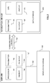
- the server 150 includes, in addition to other components which may not be illustrated, a processor 154 operatively connected to a memory 156 and further operatively connected, via a wired or wireless connection 158, to a mass data storage device 160.
- the mass storage device 160 contains a store of navigation data and map information, and can again be a separate device from the server 150 or can be incorporated into the server 150.
- the processor 154 is further operatively connected to transmitter 162 and receiver 164, to transmit and receive information to and from navigation device 200 via communications channel 152.
- the signals sent and received may include data, communication, and/or other propagated signals.
- the transmitter 162 and receiver 164 may be selected or designed according to the communications requirement and communication technology used in the communication design for the navigation system 200. Further, it should be noted that the functions of transmitter 162 and receiver 164 may be combined into a single transceiver.
- the navigation device 200 can be arranged to communicate with the server 150 through communications channel 152, using transmitter 166 and receiver 168 to send and receive signals and/or data through the communications channel 152, noting that these devices can further be used to communicate with devices other than server 150.
- the transmitter 166 and receiver 168 are selected or designed according to communication requirements and communication technology used in the communication design for the navigation device 200 and the functions of the transmitter 166 and receiver 168 may be combined into a single transceiver as described above in relation to Figure 2 .
- the navigation device includes a data storage device 170 (which may comprise any combination of ROM, RAM and disk based or solid state storage device) as well as other hardware and/or functional parts, which will be described later herein in further detail.
- a data storage device 170 (which may comprise any combination of ROM, RAM and disk based or solid state storage device) as well as other hardware and/or functional parts, which will be described later herein in further detail.
- Software stored in server memory 156 provides instructions for the processor 154 and allows the server 150 to provide services to the navigation device 200.
- a service provided by the server 150 may involve processing requests from the navigation device 200 and transmitting navigation data from the mass data storage 160 to the navigation device 200.
- Another service that can be provided by the server 150 includes processing the navigation data using various algorithms for a desired application and sending the results of these calculations to the navigation device 200.
- the server 150 constitutes a remote source of data accessible by the navigation device 200 via a wireless channel.
- the server 150 may include a network server located on a local area network (LAN), wide area network (WAN), virtual private network (VPN), etc.
- LAN local area network
- WAN wide area network
- VPN virtual private network
- the server 150 may include a personal computer such as a desktop or laptop computer, and the communication channel 152 may be a cable connected between the personal computer and the navigation device 200.
- a personal computer may be connected between the navigation device 200 and the server 150 to establish an internet connection between the server 150 and the navigation device 200.
- the server comprises a processing resource, comprising any number and type of processing devices (linked together or separate), remote from the navigation device 200 and with which the navigation device can communicate by means or a wired or wireless communications channel.
- the navigation device 200 may be provided with information from the server 150 via information downloads which may be periodically updated automatically or upon a user connecting the navigation device 200 to the server 150 and/or may be more dynamic upon a more constant or frequent connection being made between the server 150 and navigation device 200 via a wireless mobile connection device and TCP/IP connection for example.
- the processor 154 in the server 150 may be used to handle the bulk of processing needs, however, a processor (not shown in Figure 2 ) of the navigation device 200 can also handle much processing and calculation, oftentimes independent of a connection to a server 150.
- the block diagram of the navigation device 200 is not inclusive of all components of the navigation device, but is only representative of many example components.
- the navigation device 200 is located within a housing (not shown).
- the navigation device 200 includes a processing resource comprising, for example, the processor 202 mentioned above, the processor 202 being coupled to an input device 204 and a display device, for example a display screen 206.
- a processing resource comprising, for example, the processor 202 mentioned above, the processor 202 being coupled to an input device 204 and a display device, for example a display screen 206.
- the input device 204 represents any number of input devices, including a keyboard device, voice input device, touch panel and/or any other known input device utilised to input information.
- the display screen 206 can include any type of display screen such as a Liquid Crystal Display (LCD), for example.
- LCD Liquid Crystal Display
- one aspect of the input device 204, the touch panel, and the display screen 206 are integrated so as to provide an integrated input and display device, including a touchpad or touchscreen input 250 ( Figure 4 ) to enable both input of information (via direct input, menu selection, etc.) and display of information through the touch panel screen so that a user need only touch a portion of the display screen 206 to select one of a plurality of display choices or to activate one of a plurality of virtual or "soft" buttons.
- the processor 202 supports a Graphical User Interface (GUI) that operates in conjunction with the touchscreen.
- GUI Graphical User Interface
- the processor 202 is operatively connected to and capable of receiving input information from input device 204 via a connection 210, and operatively connected to at least one of the display screen 206 and the output device 208, via respective output connections 212, to output information thereto.
- the navigation device 200 may include an output device 208, for example an audible output device (e.g. a loudspeaker).
- an audible output device e.g. a loudspeaker
- input device 204 can include a microphone and software for receiving input voice commands as well.
- the navigation device 200 can also include any additional input device 204 and/or any additional output device, such as audio input/output devices for example.
- the processor 202 is operatively connected to memory 214 (which may comprise any combination of ROM, RAM, disk drive or solid state storage devices, and may be part of the aforementioned data storage device 170) via connection 216 and is further adapted to receive/send information from/to input/output (I/O) ports 218 via connection 220, wherein the I/O port 218 is connectible to an I/O device 222 external to the navigation device 200.
- the external I/O device 222 may include, but is not limited to an external listening device, such as an earpiece for example.
- connection to I/O device 222 can further be a wired or wireless connection to any other external device such as a car stereo unit for hands-free operation and/or for voice activated operation for example, for connection to an earpiece or headphones, and/or for connection to a mobile telephone for example, wherein the mobile telephone connection can be used to establish a data connection between the navigation device 200 and the Internet or any other network for example, and/or to establish a connection to a server via the Internet or some other network for example.
- any other external device such as a car stereo unit for hands-free operation and/or for voice activated operation for example, for connection to an earpiece or headphones, and/or for connection to a mobile telephone for example
- the mobile telephone connection can be used to establish a data connection between the navigation device 200 and the Internet or any other network for example, and/or to establish a connection to a server via the Internet or some other network for example.
- Figure 3 further illustrates an operative connection between the processor 202 and an antenna/receiver 224 via connection 226, wherein the antenna/receiver 224 can be a GPS antenna/receiver for example.
- the antenna and receiver designated by reference numeral 224 are combined schematically for illustration, but that the antenna and receiver may be separately located components, and that the antenna may be a GPS patch antenna or helical antenna for example.
- the electronic components shown in Figure 3 are powered by one or more power sources (not shown) in a conventional manner.
- the components shown in Figure 3 may be in communication with one another via wired and/or wireless connections and the like.
- the navigation device 200 described herein can be a portable or handheld navigation device 200.
- the portable or handheld navigation device 200 of Figure 3 can be connected or "docked" in a known manner to a vehicle such as a bicycle, a motorbike, a car or a boat for example. Such a navigation device 200 is then removable from the docked location for portable or handheld navigation use.
- the navigation device 200 may be a unit that includes the integrated input and display device 206 and the other components of Figure 2 (including, but not limited to, the internal GPS receiver 224, the microprocessor 202, a power supply (not shown), memory systems 214, etc.).
- the navigation device 200 may sit on an arm 252, which itself may be secured to a vehicle dashboard/window/etc. using a suction cup 254.
- This arm 252 is one example of a docking station to which the navigation device 200 can be docked.
- the navigation device 200 can be docked or otherwise connected to the arm 252 of the docking station by snap connecting the navigation device 200 to the arm 252 for example.
- the navigation device 200 may then be rotatable on the arm 252.
- a button (not shown) on the navigation device 200 may be pressed, for example.
- Other equally suitable arrangements for coupling and decoupling the navigation device 200 to a docking station are well known to persons of ordinary skill in the art.
- the processor 202 and memory 214 of the navigation device cooperate to support a BIOS (Basic Input/Output System) 282 that functions as an interface between functional hardware components 280 of the navigation device 200 and software executed by the device.
- BIOS Basic Input/Output System
- the processor 202 is configured to load an operating system 284 from the memory 214, and the operating system provides a processing environment in which application software 286 (implementing some or all of the route planning, navigation and other functionality described herein) can run.
- the application software 286 provides an operational environment including a GUI that supports core functions of the navigation device, for example map viewing, route planning, navigation functions and other functions associated therewith.
- Map ShareTM a system, such as Map ShareTM, whereby users can choose to provide feedback to the map provider (who may or may not be the same entity from whom users source navigation devices) concerning corrections that might be appropriate for application to the digital map data held by the map provider.
- Map ShareTM it will be appreciated that the present invention is applicable to any user feedback system for navigation map data, and as such the scope of the present invention should not be interpreted as being limited solely for application to the TomTom Map ShareTM system.
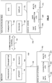
- the mass data storage 160 of the server 150 is configured to include a map data store 300, a correction log 302 and a route log 304.
- data storage 170 of the navigation device 200 includes a map data store 306, a user correction log 308 and a route log 310.
- the server 150 also maintains a log of those user devices that have opted in to the user feedback system.
- the map data stores 300, 306 include digital map data that is used by navigation devices, in a known manner, to provide users with the ability to navigate between locations in the map and to provide rendered maps for display to users.
- the server-side correction log 302 includes details of map correction requests submitted by users for incorporation into the digital map defined by the digital data held in the map data store 300 if it is appropriate to do so, and the server-side route log 304 includes data concerning the routes travelled by navigation device users who have subscribed to the navigation data improvement system.
- the server-side route log 304 includes, for each route store, data defining the route travelled as well as an identifier that uniquely identifies the navigation device used whilst that route was being travelled.
- the user correction log 308 comprises a database of instances where the user has indicated that a map data correction is required and the type of correction that the user believes should be made. As will be appreciated by persons skilled in the art, such a list can be compiled in a number of different ways, one of which will later be described. Depending on the type of connection between the navigation device 200 and server 150, data from the user correction log 308 can be transferred to the server 150 whilst the navigation device is still mobile, or in a particularly preferred implementation the log can be transferred to the server when the navigation device is next connected to the server for updating.
- the route log 310 comprises a database of routes travelled by the user's navigation device 200; typically only the routes travelled since the last time the navigation device was connected to the server.
- the database includes details of those routes where the device was operated to guide the user to a selected destination, and may also include details of routes travelled whist in free-driving mode.
- map data updates are provided from the server-side map data store 300 to the navigation device 200 for storage in the navigation device map data store 306, and data from the user correction log 308 and route log 310 (if any is stored) is transferred from the navigation device 200 to the server 150 for storage in the correction log 302 and route log, respectively.
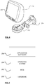
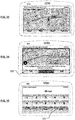
- FIGs. 7 to 18 there are shown various screenshots from a TomTomTM Go 720 navigation device which illustrate one way in which a user of a navigation device can log a correction that they believe needs to be made to the navigation data, in this instance the navigation data stored in their device
- the device is displaying a map of the area of London surrounding Bouverie Street. Touching the screen of the device causes it to display a number of options, as shown in Fig. 8 , and a continuation arrow 312. Touching the continuation arrow 312 causes the device to display, as shown in Fig. 9 , another series of options that include a virtual button 314 labelled "map corrections".
- Touching the "map corrections" button 314 causes the device to display the map corrections options shown in Fig. 10 , which options include a virtual button 316 labelled "correct a map error". Touching this button 316 causes the device to display, as shown in Fig. 11 , a number of virtual buttons that each correspond to a different type of map correction.
- the TomTom Go 720 provides seven predefined types of correction (only five of which are shown in Fig. 11 ) and a "report other error" which allows users to select types of error other than the seven predefined error types.
- the incorrect speed limit is associated with the road in the vicinity of the device's current location, namely Bouverie Street, London.
- Touching a virtual button 320 labelled "near you” causes the device to display a map of the local area as shown in Fig. 12 .
- the user can then select the street in the local area (in this example: Fleet Street) that requires correction of the speed limit associated with it by touching the screen and once selected, as shown in Fig. 13 , at least part of the chosen road is highlighted and the name of the road is displayed.
- the user is then asked to confirm, as shown in Fig. 14 , whether the highlighted part of the road is the part that the user intended to select, and on touching the virtual button 322 labelled "Yes" the device generates the display indicated in Fig. 15 and the user is asked to enter the correct speed limit for the section of road selected in Fig. 14 .
- the correct speed limit for this section of road is 30 miles per hour.
- selecting virtual button 324 labelled “done” causes the device to generate a display as shown in Fig. 16 which requests the user to confirm that the change is "permanent and valid for normal passenger cars" (we assume it is in this example), following which the user is advised by way of the display shown in Fig. 17 that their map has been changed and is prompted to indicate by touching the appropriate virtual button whether they wish to share this change with other TomTom users.
- the virtual button 326 marked "yes" the location of the correction If the user touches the virtual button 326 marked "yes" the location of the correction, the nature of the correction and, in this case, the new data associated with that location are stored in the user correction log 308 for download to the correction log 302 of the server 150 when the device is next in communication with the server, and the user is advised accordingly as shown in Fig. 18 .
- this process is quite involved and as such may be involved to be undertaken whilst the device is being used, particularly if the device is being used for navigation in a vehicle.
- the software provides the user with the option to overlay the displayed navigation map, as shown in Fig. 19 , with a virtual "report" button 324, and if the user should press this button the device provides a display as shown in Fig. 20 to indicate to the user that the location where the report button was pressed has been logged so that the process depicted in Figs. 7 to 18 can be undertaken at a more convenient time when the user next presses the "map corrections" button 314 shown in Fig. 9 .
- the server processor is configured to invoke and execute software modules in server memory 156.
- the processor 154 and memory 156 cooperate to support a BIOS (Basic Input/Output System) 330 that functions as an interface between functional hardware components of the server 150 and software executed by the server 150.
- BIOS Basic Input/Output System
- the processor 154 is configured to load an operating system 332, for example from the memory 156, for execution in the processing environment provided by the memory 156.
- the operating system 332 provides a processing environment in which application software 334 can run.
- the server application software 334 comprises a correction selection module 336, a device selection module 338, a user request generator 340, a response review module 342 and a correction application module 344.
- the correction selection module 336 is configured to select notified corrections and associated locations from the correction log 302 for validation by navigation device users.
- the module may select notified corrections in turn (starting with the oldest notified errors first), at random, or once multiple users (for example, more users than a predetermined minimum number of users) have reported a particular problem.
- the server may be configured to implement a correction log maintenance module (not shown in Fig. 21 ) that is configured to review the correction log and exclude from consideration for user validation those corrections that have been requested by only a small number of users or on a small number of occasions.
- correction log maintenance module (not shown in Fig. 21 ) that is configured to review the correction log and exclude from consideration for user validation those corrections that have been requested by only a small number of users or on a small number of occasions.
- These corrections are likely to be relatively minor in nature or to relate to relative obscure locations that are unlikely to be visited by many users, and as such may be more appropriate for validation by an employee, for example, than by means of a user validation process of the type described herein.
- the device selection module 338 is configured to inspect the route log 304 and, in one configuration, select devices that have previously travelled routes which include the particular location associated with the correction selected for validation from the correction log 302 by the correction selection module 336.
- the device selection process can take a number of different forms.
- the device selection module 338 may be configured to select the first X devices from the route log that have travelled a route which includes the location associated with the selected correction (where X is a number chosen as the minimum number of user devices that must be selected for a requested correction).
- the number X may be a function of the number of devices with routes that pass the location.
- the number X may be, preferably automatically, dynamically adjusted upwards for locations that have been visited by many devices and downwards for locations that have been visited by a smaller number of devices.
- the device selection module 338 may be configured to identify a set of devices which have travelled a route that includes the location associated with the selected correction, and then randomly select from this set a subset of X devices (where, as before, X is a number chosen (optionally dynamically) for the system) that are to be contacted for correction validation purposes. This random selection is particularly preferred as it makes it less likely that a chosen device will be associated with a false correction that has been deliberately submitted to adversely affect the integrity of the map data.
- the device selection module 338 may be configured to identify a set of devices which have travelled a route that includes the location associated with the selected correction, rank the set of devices (for example by the number of times that the device concerned has travelled through the selected location), and then select a subset of X devices (where, as before, X is a number chosen (optionally dynamically) for the system) consisting of the devices that have most frequently visited the location and which are to be contacted for correction validation purposes. As before, the devices selected for inclusion in this subset may be chosen at random from a subset consisting of those devices that have most frequently visited the location in question.
- the device selection module may be configured to select for consideration not only those devices that have actually passed through the location in question, but also those devices that have been in the vicinity of the location in question, for example within a kilometre or less of the location in question.
- the device selection module may be configured to dynamically adjust the definition of the "vicinity" for a given location in accordance with the number of routes in the log that actually include the particular location associated with the requested correction. For example, for a correction associated with a particular location that has been visited on many occasions in the past, the device selection module may adjust the definition of the "vicinity" of that location downwards, perhaps to include only those devices for whom routes are recorded that actually include the location in question.
- the device selection module may adjust the definition of the "vicinity" of that location upwards, perhaps to include those devices for whom routes are recorded that include locations within a given distance (for example a kilometre) of the location associated with the requested correction.
- the user request generator 340 is configured to generate, for the particular correction type included in the correction log 302, user requests that each comprise a set of instructions for transfer to each of the navigation devices selected by the device selection module 338.
- the instructions when executed by the respective processors 202 of the navigation devices 200 will cause those devices to generate and present to the user of the device a request for user assistance in the validation of a reported map data correction.
- the user requests, once generated, are stored by the server (for example in the mass data storage 160) for transfer to the navigation devices associated with each generated request on the next occasion that the device communicates with the server 150.
- the user request instructions identify to the processors of the navigation devices a location (which may comprise a single location or a zone comprising a plurality of locations a predetermined distance from a location with which the requested correction is associated) with which the user requests are associated, and the processors of the navigation devices are configured to execute the instructions of the user requests only when a position determination module (to be later described) of each navigation device indicates that the navigation device is at or near the location in question.
- the instructions may be configured to control the processor to present the request to the user at a location which is a predetermined distance before the location associated with the requested correction, and in a modification of this arrangement the predetermined distance may be varied in accordance with the type of correction with which the user is being asked to assist.
- the user may be presented with the request shortly before they enter the street in question (on the rationale that street signs are usually provided at entrances to a street).
- the user may be presented with the request only once they are actually in the street in question (on the rationale that speed limit signs are usually provided at regular intervals along a street).
- the user request instructions could be configured to instruct the processor to divert the user from their chosen or current route to the location associated with the correction. For example, a user could be presented with a message asking for assistance with a correction that is associated with a minor street that is not far away from a street along which they are proceeding, and if the user should indicate that they are prepared to assist with the request, the processor could vary the planned route to include the street in question or in the case where the user is using the device in a free driving mode, issue the user with instructions to guide the user from their current position to the location in question, and optionally back to the location they were at before they were diverted.
- the user requests provided to the user may take a number of forms. They may comprise visually displayed requests for assistance, audio requests for assistance or, in a particularly preferred arrangement, combinations of audio and visual requests for assistance.
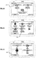
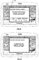
- Fig. 22 is an illustrative representation for a user feedback request concerning a reporting correction to the name of a particular street.
- the display of the navigation device is overlaid with a feedback request 346 that includes a textual message indicating the nature of the problem with the map data at this location (in this instance, the fact that the street name is unknown), and three virtual buttons 348 350 and 352 marked "YES", "LATER” and "DECLINE” respectively.
- the display of this request may also be announced to the user using audio, for example by replaying audio corresponding to the textual message included in the request 346.
- the navigation device If the user should touch the screen in the vicinity of the "YES" button, the navigation device generates a display such as that shown in Fig. 23 requesting the user, in this instance, to say the name of the road after an audio tone has been played.
- the display shown in Fig. 23 may, as before, be accompanied by a corresponding audio message to the user of the device, and a short while after the user has been notified the navigation device generates an audio tone and switches to a record mode whereby input device 204 (which in this instance includes a microphone) is activated and audio received via the input device is recorded to the memory 214 of the navigation device for transfer to the server 150 via the communications channel 152 when the navigation device is next in contact with the server 150.
- input device 204 which in this instance includes a microphone
- user responses are stored along with information that allows the server to associate the response with a particular requested correction.
- each requested correction (or group of individual requests that relate to the same error in the map data) could be assigned a reference number that is stored with the user response in the memory 214.
- the location associated with the user request could be stored with the user response, and other equally plausible arrangements will be immediately apparent to persons of ordinary skill in the art.
- the processor records an instruction to seek assistance from the user at a later point in time.
- a message similar to that shown in Fig. 20 could be displayed, and the user then prompted to provide assistance when they next select the map corrections option shown in Fig. 9 .
- the user request is cleared from the display and the processor records that the user has declined to assist with this particular user request.
- the processor may then be configured to delete the request, or to notify the server 150 when the navigation device is next connected that the user has declined this particular user request.
- the server could be configured to maintain a log of declined requests and in the event that more than a given number of requests are declined by the user of a particular device, to issue instructions for transfer to the user of that device to cause the processor to indicate to the user of the device that they have declined requests for assistance on multiple occasions in the past, and provide the user with the option to remove their device from the list of devices that the server can approach for assistance with map data corrections.
- the user request generated by the processor could provide the user with the option to provide a textual response, or indeed a mix of textual and audio responses.
- the server may be configured simply to receive and store user responses for later consideration by a human operator, in particular for consideration whether at least a proportion of the responses are sufficiently similar to merit correction of the map data.
- the server may be configured to employ a response review module 342 that is operable to review received responses to determine whether at least a predetermined proportion of those responses include the same or similar user response.
- the response review module may be configured to review received responses only when responses have been received from a predetermined proportion of the devices to which user requests were transmitted, and to indicate that a particular response is valid when at least a predetermined proportion of received responses are identical or at least similar.
- the response review module may be configured to implement a statistical review of responses received whereby each new response is compared to existing responses until a statistically significant number of responses with the same or similar information have been received.
- the response review module 342 may simply be configured to compare text of received responses, and to deem a given response to be valid if it is the same or similar to a number of other responses.
- the degree of similarity that must occur for responses to be deemed to be the same may be automatically adjusted with the type of correction request so that for street names (where typographical errors may occur) a lower level of similarity is required than might be required for speed limits, for example.
- the response review module 342 may be configured to invoke speech analysis functionality to convert received audio into a computer intelligible form before received responses are compared. It is also recognised that a comparison of the received audio could be undertaken, using conventional audio analysis techniques, but it is anticipated that such an approach may prove less useful given different audio qualities of the environments in which the responses are captured and likely differences between users.
- the response review module may also be configured to automatically delete responses relating to corrections that have already been made to the map data. In this way, a response that is late received (for example because the user has not connected their device to the server 150 for a relatively long period of time, or has been tardy in inputting the correction) can readily be ignored by the server 150.
- the server may optionally invoke a correction application module 344 that is configured to automatically apply a determined correction to the map data stored in the mass storage device 160 of the server 150.
- the navigation device processor 202 is configured to invoke and execute software modules in memory 214.
- the processor 202 and memory 214 cooperate to support a BIOS (Basic Input/Output System) 280 that functions as an interface between functional hardware components of the navigation device 200 and software executed by the processor 202.
- BIOS Basic Input/Output System
- the processor 202 is configured to load an operating system 284 that provides a processing environment in which application software 286 can run.
- the application software includes conventional navigation device software modules such as route planning, navigation, and map rendering modules the like of which are well known in the art and for brevity will not be described herein in detail.
- the route planning module enables a user of the device to input a start location and plan a route to an inputted destination
- the navigation module enables the device to receive GPS signals, determine the device location and generate route guidance instructions for provision to the user
- the map view rendering module is configured to generate displays of regions of the digital map, for example a region where the device is currently located as determined by the navigation module.
- the application software also includes a user request module 354 and a user response module 356.
- the user request module 354 is configured to cooperate with the navigation module to invoke, at an appropriate location defined by the user feedback request received from the server, instructions included in the user feedback request to generate an appropriate user feedback request - such as that shown in Fig. 22 - for display to the user on the display of the navigation device 200.
- the user response module 356 functions to record that the user does not wish to respond at this time and to configure the navigation device to prompt the user to respond at a later point in time, to record that the user does not wish to respond (and optionally notify the server of this in due course) or to record a user response to the displayed request in the memory 214 for later upload to the server 150.
- the device is predominately operated in a mobile mode without a connection to the server 150, but it will be apparent to persons skilled in the art that the teachings of the present invention could equally well be implemented in a system where the location, or at least the general location, of each navigation device is known.
- the navigation device could be configured to periodically transmit its location, as determined by the navigation module from received GPS signals, to the server 150 using, for example, an integral or connected mobile communications device (such as a mobile telephone or a telephony equipped PDA).
- the approximate location of the navigation device could be determined by means of conventional triangulation techniques that enable the approximate location of a mobile telephone to be calculated based on its communications with mobile transceiver stations of the mobile telephone network.
- the server could be configured to implement a pseudo-real time system by sending user requests, for example by means of a mobile communications device that forms part of or to which the device is connected, to a selection of those navigation devices that are currently in the vicinity of a location that is associated with a reported need for map data correction.
- the navigation devices could be preloaded with form data for different types of user request, and in such an arrangement the user requests transmitted by the server (for example in cooperation with a mobile telephone network) need only comprise unique data pertaining to the particular correction being investigated at that time.
- FIGs. 25 and 26 there are shown in the form of flow diagrams the various functional steps in the process of flagging map data as needing correction, and subsequently enlisting the help of users in validating a requested correction.
- a first step the user switches on their navigation device and operates it either as a route guidance tool or in a free-driving mode. If the user should notice an error in the map data whilst using the device, the user can notify the device of the error, whereupon the device liaises with the user to determine the type of error noted, the correction required and the location that the error is associated with records the error as a correction request in the device.
- the device When the device connects with the server, for example when the device is next coupled to the device via an internet or immediately if the device is connected to the server whilst being operated, the device transmits the error correction request to the server.
- the server on receipt of a correction request from a device the server stores the request in the correction request store.
- the server selects a request for validation by users, selects the set of devices that are to be asked to assist with validation of the correction request, and generates a user request for transmission to the selected user devices (for example when those devices are next connected to the server). In due course the generated user requests are transmitted to the selected devices.
- the devices receive the transmitted user requests, and obtain a response from the user in the manner aforementioned.
- the responses are then transmitted back to the server for processing.
- the server receives the user responses from the navigation devices, analyses the responses received, and determines whether the responses indicate that the requested correction is valid. If the requested correction is determined to be valid, the map data is amended accordingly and the process ceases. If the requested correction is not determined to be valid, processing ceases.
- the navigation device may utilise any kind of position sensing technology as an alternative to (or indeed in addition to) GPS.
- the navigation device may utilise using other global navigation satellite systems such as the European Galileo system. Equally, it is not limited to satellite based but could readily function using ground based beacons or any other kind of system that enables the device to determine its geographic location.
- Alternative embodiments of the invention can be implemented as a computer program product for use with a computer system, the computer program product being, for example, a series of computer instructions stored on a tangible data recording medium, such as a diskette, CD-ROM, ROM, or fixed disk, or embodied in a computer data signal, the signal being transmitted over a tangible medium or a wireless medium, for example, microwave or infrared.
- the series of computer instructions can constitute all or part of the functionality described above, and can also be stored in any memory device, volatile or non-volatile, such as semiconductor, magnetic, optical or other memory device.
Description
- The present invention relates, in general, to validating map data corrections. Embodiments of the invention relate to a method for use in the validation of a correction to map data for a geographic location, and to a system for use in the validation of a correction to map data for a geographic location. Other embodiments relate to a navigation device and a processing resource for use in the system, and to a computer program.
- Portable computing devices, for example Portable Navigation Devices (PNDs) that include GPS (Global Positioning System) signal reception and processing functionality are well known and are widely employed as in-car or other vehicle navigation systems, either as devices that are permanently mounted in the vehicle or as devices that can be removed from the vehicle.
- In general terms, a modern PND comprises a processor, memory (at least one of volatile and non-volatile, and commonly both), and map data stored within said memory. The processor and memory cooperate to provide an execution environment in which a software operating system may be established, and additionally it is commonplace for one or more additional software programs to be provided to enable the functionality of the PND to be controlled, and to provide various other functions.
- Typically these devices further comprise one or more input interfaces that allow a user to interact with and control the device, and one or more output interfaces by means of which information may be relayed to the user. Illustrative examples of output interfaces include a visual display and a speaker for audible output. Illustrative examples of input interfaces include one or more physical buttons to control on/off operation or other features of the device (which buttons need not necessarily be on the device itself but could be on a steering wheel if the device is built into a vehicle), and a microphone for detecting user speech. In one particular arrangement, the output interface display may be configured as a touch sensitive display (by means of a touch sensitive overlay or otherwise) additionally to provide an input interface by means of which a user can operate the device by touch.
- Devices of this type will also often include one or more physical connector interfaces by means of which power and optionally data signals can be transmitted to and received from the device, and optionally one or more wireless transmitters/receivers to allow communication over cellular telecommunications and other signal and data networks, for example Bluetooth, Wi-Fi, Wi-Max, GSM, UMTS and the like.
- PNDs of this type also include a GPS antenna by means of which satellite-broadcast signals, including location data, can be received and subsequently processed to determine a current location of the device.
- The PND may also include electronic gyroscopes and accelerometers which produce signals that can be processed to determine the current angular and linear acceleration, and in turn, and in conjunction with location information derived from the GPS signal, velocity and relative displacement of the device and thus the vehicle in which it is mounted. Typically, such features are most commonly provided in in-vehicle navigation systems, but may also be provided in PNDs if it is expedient to do so.
- The utility of such PNDs is manifested primarily in their ability to determine a route between a first location (typically a start or current location) and a second location (typically a destination). These locations can be input by a user of the device, by any of a wide variety of different methods, for example by postcode, street name and house number, previously stored "well known" destinations (such as famous locations, municipal locations (such as sports grounds or swimming baths) or other points of interest), and favourite or recently visited destinations.
- Typically, the PND is enabled by software for computing a "best" or "optimum" route between the start and destination address locations from the map data. A "best" or "optimum" route is determined on the basis of predetermined criteria and need not necessarily be the fastest or shortest route. The selection of the route along which to guide the driver can be very sophisticated, and the selected route may take into account existing, predicted and dynamically and/or wirelessly received traffic and road information, historical information about road speeds, and the driver's own preferences for the factors determining road choice (for example the driver may specify that the route should not include motorways or toll roads).
- In addition, the device may continually monitor road and traffic conditions, and offer to or choose to change the route over which the remainder of the journey is to be made due to changed conditions. Real time traffic monitoring systems, based on various technologies (e.g. mobile phone data exchanges, fixed cameras, GPS fleet tracking) are being used to identify traffic delays and to feed the information into notification systems.
- PNDs of this type may typically be mounted on the dashboard or windscreen of a vehicle, but may also be formed as part of an on-board computer of the vehicle radio or indeed as part of the control system of the vehicle itself. The navigation device may also be part of a hand-held system, such as a PDA (Portable Digital Assistant), a media player, a mobile phone or the like, and in these cases, the normal functionality of the hand-held system is extended by means of the installation of software on the device to perform both route calculation and navigation along a calculated route.
- Route planning and navigation functionality may also be provided by a desktop or mobile computing resource running appropriate software. For example, the Royal Automobile Club (RAC) provides an on-line route planning and navigation facility at http://www.rac.co.uk, which facility allows a user to enter a start point and a destination whereupon the server with which the user's computing resource is communicating calculates a route (aspects of which may be user specified), generates a map, and generates a set of exhaustive navigation instructions for guiding the user from the selected start point to the selected destination. The facility also provides for pseudo three-dimensional rendering of a calculated route, and route preview functionality which simulates a user travelling along the route and thereby provides the user with a preview of the calculated route.
- In the context of a PND, once a route has been calculated, the user interacts with the navigation device to select the desired calculated route, optionally from a list of proposed routes. Optionally, the user may intervene in, or guide the route selection process, for example by specifying that certain routes, roads, locations or criteria are to be avoided or are mandatory for a particular journey. The route calculation aspect of the PND forms one primary function, and navigation along such a route is another primary function.
- During navigation along a calculated route, it is usual for such PNDs to provide visual and/or audible instructions to guide the user along a chosen route to the end of that route, i.e. the desired destination. It is also usual for PNDs to display map information on-screen during the navigation, such information regularly being updated on-screen so that the map information displayed is representative of the current location of the device, and thus of the user or user's vehicle if the device is being used for in-vehicle navigation.
- An icon displayed on-screen typically denotes the current device location, and is centred with the map information of current and surrounding roads in the vicinity of the current device location and other map features also being displayed. Additionally, navigation information may be displayed, optionally in a status bar above, below or to one side of the displayed map information, examples of navigation information include a distance to the next deviation from the current road required to be taken by the user, the nature of that deviation possibly being represented by a further icon suggestive of the particular type of deviation, for example a left or right turn. The navigation function also determines the content, duration and timing of audible instructions by means of which the user can be guided along the route. As can be appreciated a simple instruction such as "turn left in 100 m" requires significant processing and analysis. As previously mentioned, user interaction with the device may be by a touch screen, or additionally or alternately by steering column mounted remote control, by voice activation or by any other suitable method.
- A further important function provided by the device is automatic route re-calculation in the event that: a user deviates from the previously calculated route during navigation (either by accident or intentionally); real-time traffic conditions dictate that an alternative route would be more expedient and the device is suitably enabled to recognize such conditions automatically, or if a user actively causes the device to perform route re-calculation for any reason.
- It is also known to allow a route to be calculated with user defined criteria; for example, the user may prefer a scenic route to be calculated by the device, or may wish to avoid any roads on which traffic congestion is likely, expected or currently prevailing. The device software would then calculate various routes and weigh more favourably those that include along their route the highest number of points of interest (known as POIs) tagged as being for example of scenic beauty, or, using stored information indicative of prevailing traffic conditions on particular roads, order the calculated routes in terms of a level of likely congestion or delay on account thereof. Other POI-based and traffic information-based route calculation and navigation criteria are also possible.
- Although the route calculation and navigation functions are fundamental to the overall utility of PNDs, it is possible to use the device purely for information display, or "free-driving", in which only map information relevant to the current device location is displayed, and in which no route has been calculated and no navigation is currently being performed by the device. Such a mode of operation is often applicable when the user already knows the route along which it is desired to travel and does not require navigation assistance.
- Devices of the type described above, for example the 920T model manufactured and supplied by TomTom International B.V., provide a reliable means for enabling users to navigate from one position to another. Such devices are of great utility when the user is not familiar with the route to the destination to which they are navigating.
- As mentioned above, the memory of the PND stores map data used by the PND not only to calculate routes and provide necessary navigation instructions to users, but also to provide visual information to users through the visual display of the PND. As is known in the art, map information can be expressed in a number of ways and indeed can comprise a number of separate information components, which are used in combination by the PND.
- Map databases often provide details of road networks for an entire country or even an entire continent, and as such they typically include a vast amount of information. The real road network that is embodied in the map database changes over time, and whilst it is conventional for map providers to provide updates for application to map databases, the rate of change inevitably means that even the most up to date databases include errors that require correction. For example, new roads may be built after a given map has been created, or existing routes may be temporarily or permanently diverted. Furthermore, as the type of information included in these map databases increases, for example to include information regarding points of interest (such as theme parks, museums, banks or filling stations), so the problem of map data accuracy is compounded as new points of interest appear and old points of interest disappear.
- Conventionally the accuracy of map data is checked by sending out individuals, typically employees of the map provider, to follow the map and note any inconsistencies or errors they encounter. In some instances users may be provided with the opportunity to participate in the process of map verification by logging errors in the map data that they encounter as they use their devices.
- Map Share™, provided by TomTom™, is an illustrative example of such functionality. Users of certain TomTom™ navigation devices can use the Map Share™ functionality to share corrections that they make to the map data stored in their devices with other TomTom™ users who have agreed to be part of the Map Share™ community. Users can choose to receive Map Share™ map data corrections, and can assign a level of trust to indicate whether they are happy to include all received corrections in their map data, or whether they only wish to include officially sanctioned and verified Map Share™ corrections.
- Whilst the functionality provided by Map Share™ does help to reduce the incidence of errors in the map data held by those users who sign up to the service, there is a still a degree of verification that needs to be undertaken before officially verified corrections can be released to all users as a map data update from the map provider. This verification process necessarily takes time to complete, and as such if a user wishes to have the most up to date map data available they necessarily need to choose to include map data that has not yet been officially verified.
- Whilst most users of functionality such as Map Share™ are seeking to improve the accuracy of the map data for all users, there is unfortunately a significant minority of device users who deliberately seek to introduce errors into the map data by reporting "corrections" that they know to be false. Those users of the Map Share functionality who have opted to trust all corrections submitted by the community can find that these deliberately false "corrections" get imported into their map data, and can be inconvenienced if they should rely on those "corrections" when planning a route.
- One solution to this problem would be for the map provider to validate all user submitted corrections before releasing a map update to users, but as aforementioned validation processes are in the first instance relatively expensive to undertake and in the second instance necessarily take time to complete, and whilst such processes are being completed users have no option but to rely on incorrect map data.
- It is clear, therefore, that it would be an advantage if processes whereby users can provide information concerning the accuracy of map data can be improved to simultaneously reduce the requirement for validation by the map provider and the likelihood of the map data being affected by false map corrections. One illustrative aim of the present invention is to provide such an arrangement.
-
WO 2008/019882 A1 discloses a method of and an apparatus for organizing map correction data, wherein validity or credibility of map fixes and reports sent by users is assessed. -
US 2008/120171 A1 discloses a map information processing apparatus that is arranged to detect presence of a new road by comparing its present location to map information stored thereon. A registration decision as to a newly detected road is made depending upon a confirmation received from a user. - In pursuit of this aim, a first aspect of the present invention provides a server configured for use in a system for use in the validation of a correction to map data, according to
claim 1. - A second aspect of the present invention relates to a system for use in the validation of a correction to map data, according to
claim 8. - A third aspect of the present invention provides a method for use in the validation of a correction to map data, according to claim 10
- A fourth aspect of the present invention provides a computer program according to claim 14.
- Advantages of these embodiments are set out hereafter, and further details and features of each of these embodiments are defined in the accompanying dependent claims and elsewhere in the following detailed description.
- It is thus possible to provide a powerful means for validating requested corrections to map data in a navigation system. The arrangements disclosed avoid much of the expense associated with traditional methods of validating correction requests, and facilitate a quicker respond to noted errors. Furthermore, in preferred embodiments of the invention it is significantly harder for nefarious individuals to pollute the map data with incorrect submissions.
- Illustrative embodiments of the invention will now be described, by way of example only, with reference to the accompanying drawings, in which:
-
Fig. 1 is a schematic illustration of an illustrative part of a Global Positioning System (GPS) usable by a navigation device; -
Fig. 2 is a schematic diagram of a communications system that may be employed to provide for communication between a navigation device and a server; -
Fig. 3 is a schematic illustration of electronic components of an illustrative navigation device, for example the device ofFigure 2 ; -
Fig. 4 is a schematic diagram of an arrangement for mounting and/or docking a navigation device; -
Fig. 5 is a schematic representation of an architectural stack employed by the navigation device ofFigure 3 ; -
Fig. 6 is a more detailed view of the arrangement shown inFig. 2 ; -
Figs. 7 to 18 are screenshots of an illustrative map data error reporting process; -
Figs. 19 and 20 are screenshots of an illustrative location marking process; -
Fig. 21 is a more detailed schematic representation of an architectural stack employed by the server ofFig. 6 ; -
Figs 22 and 23 are screenshots depicting an illustrative user request displayed on a navigation device; -
Fig. 24 is a more detailed schematic representation of an architectural stack employed by the navigation device ofFig. 6 ; and -
Figs. 25 and26 provide an overview in flow chart form of an illustrative embodiment of the invention. - Throughout the following description identical reference numerals will be used to identify like parts.
- Embodiments of the present invention will now be described with particular reference to a PND. It should be remembered, however, that the teachings of the present invention are not limited to PNDs but are instead universally applicable to any type of processing device that is configured to execute navigation software so as to provide route planning and/or navigation functionality. It follows therefore that in the context of the present application, a navigation device is intended to include (without limitation) any type of route planning and navigation device, irrespective of whether that device comprises a PND, a device in a vehicle such as an automobile, or indeed a computing resource, for example a personal computer (PC) (portable or otherwise), a mobile telephone or a Personal Digital Assistant (PDA) executing route planning and navigation software.
- It will also be apparent from the following that the teachings of the present invention are not limited solely to circumstances where users are following a computed route from an input start location to an input destination location, but are equally as useful when the user is using the device in the aforementioned free-driving mode.
- With the above provisos in mind, reference will now be made to
Fig. 1 of the accompanying drawings in which an illustrative satellite navigation system, in this instance, the Global Positioning System (GPS) is shown. In general, the GPS is a satellite-radio based navigation system that provides the possibility of continuously determining position, velocity, time, and in some instances direction information for an unlimited number of users. Formerly known as NAVSTAR, the GPS incorporates a plurality of satellites which orbit the earth in extremely precise orbits. Based on these precise orbits, GPS satellites can relay their location to any number of receiving units. - The GPS system is implemented when a device, specially equipped to receive GPS data, begins scanning radio frequencies for GPS satellite signals. Upon receiving a radio signal from a GPS satellite, the device determines the precise location of that satellite via one of a plurality of different conventional methods. The device will continue scanning, in most instances, for signals until it has acquired at least three different satellite signals (noting that position is not normally, but can be determined, with only two signals using other triangulation techniques). Implementing known geometric triangulation techniques, the receiver utilizes the three known positions to determine its own two-dimensional position relative to the satellites. Additionally, by acquiring a fourth satellite signal the receiving device can calculate its three dimensional position by the same geometrical calculation in a known manner. The position and velocity data can be updated in real time on a continuous basis by an unlimited number of users.
- As shown in
Figure 1 , theGPS system 100 comprises a plurality ofsatellites 102 orbiting about theearth 104. AGPS receiver 106 receives spread spectrum GPS satellite data signals 108 from a number of the plurality ofsatellites 102. The spread spectrum data signals 108 are continuously transmitted from eachsatellite 102, the spread spectrum data signals 108 transmitted each comprise a data stream including information identifying aparticular satellite 102 from which the data stream originates. TheGPS receiver 106 generally requires spread spectrum data signals 108 from at least threesatellites 102 in order to be able to calculate a two-dimensional position. Receipt of a fourth spread spectrum data signal enables theGPS receiver 106 to calculate, using a known technique, a three-dimensional position. - Turning to
Figure 2 , anavigation device 200 comprising or coupled to theGPS receiver device 106, is capable of establishing a data session, if required, with network hardware of a "mobile" or telecommunications network via a mobile device (not shown), for example a mobile telephone, PDA, and/or any device with mobile telephony or communications functionality, in order to establish a digital connection, for example a digital connection via known Bluetooth technology. Thereafter, through its network service provider, the mobile device can establish a network connection (through the Internet for example) with aserver 150. As such, a "mobile" network connection can be established between the navigation device 200 (which can be, and often times is, mobile as it travels alone and/or in a vehicle) and theserver 150 to provide a "real-time" or at least very "up to date" gateway for information. - The establishing of the network connection between the mobile device (via a service provider) and another device such as the
server 150, using the Internet for example, can be done in a known manner. In this respect, any number of appropriate data communications protocols can be employed, for example the TCP/IP layered protocol. Furthermore, the mobile device can utilize any number of communication standards such as CDMA2000, GSM, IEEE 802.11 a/b/c/g/n, etc. - Hence, it can be seen that the internet connection may be utilised, which can be achieved via data connection, via a mobile phone or mobile phone technology within the
navigation device 200 for example. - Although not shown, the
navigation device 200 may, of course, include its own mobile telephone technology within thenavigation device 200 itself (including an antenna for example, or optionally using the internal antenna of the navigation device 200). The mobile phone technology within thenavigation device 200 can include internal components, and/or can include an insertable card (e.g. Subscriber Identity Module (SIM) card), complete with necessary mobile phone technology and/or an antenna for example. As such, mobile phone technology within thenavigation device 200 can similarly establish a network connection between thenavigation device 200 and theserver 150, via the Internet for example, in a manner similar to that of any mobile device. - For telephone settings, a Bluetooth enabled navigation device may be used to work correctly with the ever changing spectrum of mobile phone models, manufacturers, etc., model/manufacturer specific settings may be stored on the
navigation device 200 for example. The data stored for this information can be updated. - In
Figure 2 , thenavigation device 200 is depicted as being in communication with theserver 150 via ageneric communications channel 152 that can be implemented by any of a number of different arrangements. Thecommunication channel 152 generically represents the propagating medium or path that connects thenavigation device 200 and theserver 150. Theserver 150 and thenavigation device 200 can communicate when a connection via thecommunications channel 152 is established between theserver 150 and the navigation device 200 (noting that such a connection can be a data connection via mobile device, a direct connection via personal computer via the internet, etc.). - The
communication channel 152 is not limited to a particular communication technology. Additionally, thecommunication channel 152 is not limited to a single communication technology; that is, thechannel 152 may include several communication links that use a variety of technology. For example, thecommunication channel 152 can be adapted to provide a path for electrical, optical, and/or electromagnetic communications, etc. As such, thecommunication channel 152 includes, but is not limited to, one or a combination of the following: electric circuits, electrical conductors such as wires and coaxial cables, fibre optic cables, converters, radio-frequency (RF) waves, the atmosphere, free space, etc. Furthermore, thecommunication channel 152 can include intermediate devices such as routers, repeaters, buffers, transmitters, and receivers, for example. - In one illustrative arrangement, the
communication channel 152 includes telephone and computer networks. Furthermore, thecommunication channel 152 may be capable of accommodating wireless communication, for example, infrared communications, radio frequency communications, such as microwave frequency communications, etc. Additionally, thecommunication channel 152 can accommodate satellite communication. - The communication signals transmitted through the
communication channel 152 include, but are not limited to, signals as may be required or desired for given communication technology. For example, the signals may be adapted to be used in cellular communication technology such as Time Division Multiple Access (TDMA), Frequency Division Multiple Access (FDMA), Code Division Multiple Access (CDMA), Global System for Mobile Communications (GSM), etc. Both digital and analogue signals can be transmitted through thecommunication channel 152. These signals may be modulated, encrypted and/or compressed signals as may be desirable for the communication technology. - The
server 150 includes, in addition to other components which may not be illustrated, aprocessor 154 operatively connected to amemory 156 and further operatively connected, via a wired orwireless connection 158, to a massdata storage device 160. Themass storage device 160 contains a store of navigation data and map information, and can again be a separate device from theserver 150 or can be incorporated into theserver 150. Theprocessor 154 is further operatively connected totransmitter 162 andreceiver 164, to transmit and receive information to and fromnavigation device 200 viacommunications channel 152. The signals sent and received may include data, communication, and/or other propagated signals. Thetransmitter 162 andreceiver 164 may be selected or designed according to the communications requirement and communication technology used in the communication design for thenavigation system 200. Further, it should be noted that the functions oftransmitter 162 andreceiver 164 may be combined into a single transceiver. - As mentioned above, the
navigation device 200 can be arranged to communicate with theserver 150 throughcommunications channel 152, usingtransmitter 166 andreceiver 168 to send and receive signals and/or data through thecommunications channel 152, noting that these devices can further be used to communicate with devices other thanserver 150. Further, thetransmitter 166 andreceiver 168 are selected or designed according to communication requirements and communication technology used in the communication design for thenavigation device 200 and the functions of thetransmitter 166 andreceiver 168 may be combined into a single transceiver as described above in relation toFigure 2 . - The navigation device includes a data storage device 170 (which may comprise any combination of ROM, RAM and disk based or solid state storage device) as well as other hardware and/or functional parts, which will be described later herein in further detail.
- Software stored in
server memory 156 provides instructions for theprocessor 154 and allows theserver 150 to provide services to thenavigation device 200. In one configuration a service provided by theserver 150 may involve processing requests from thenavigation device 200 and transmitting navigation data from themass data storage 160 to thenavigation device 200. Another service that can be provided by theserver 150 includes processing the navigation data using various algorithms for a desired application and sending the results of these calculations to thenavigation device 200. - The
server 150 constitutes a remote source of data accessible by thenavigation device 200 via a wireless channel. Theserver 150 may include a network server located on a local area network (LAN), wide area network (WAN), virtual private network (VPN), etc. - The
server 150 may include a personal computer such as a desktop or laptop computer, and thecommunication channel 152 may be a cable connected between the personal computer and thenavigation device 200. Alternatively, a personal computer may be connected between thenavigation device 200 and theserver 150 to establish an internet connection between theserver 150 and thenavigation device 200. - In general terms the server comprises a processing resource, comprising any number and type of processing devices (linked together or separate), remote from the
navigation device 200 and with which the navigation device can communicate by means or a wired or wireless communications channel. - The
navigation device 200 may be provided with information from theserver 150 via information downloads which may be periodically updated automatically or upon a user connecting thenavigation device 200 to theserver 150 and/or may be more dynamic upon a more constant or frequent connection being made between theserver 150 andnavigation device 200 via a wireless mobile connection device and TCP/IP connection for example. For many dynamic calculations, theprocessor 154 in theserver 150 may be used to handle the bulk of processing needs, however, a processor (not shown inFigure 2 ) of thenavigation device 200 can also handle much processing and calculation, oftentimes independent of a connection to aserver 150. - Referring to
Figure 3 , it should be noted that the block diagram of thenavigation device 200 is not inclusive of all components of the navigation device, but is only representative of many example components. Thenavigation device 200 is located within a housing (not shown). Thenavigation device 200 includes a processing resource comprising, for example, theprocessor 202 mentioned above, theprocessor 202 being coupled to aninput device 204 and a display device, for example adisplay screen 206. Although reference is made here to theinput device 204 in the singular, the skilled person should appreciate that theinput device 204 represents any number of input devices, including a keyboard device, voice input device, touch panel and/or any other known input device utilised to input information. Likewise, thedisplay screen 206 can include any type of display screen such as a Liquid Crystal Display (LCD), for example. - In one arrangement, one aspect of the
input device 204, the touch panel, and thedisplay screen 206 are integrated so as to provide an integrated input and display device, including a touchpad or touchscreen input 250 (Figure 4 ) to enable both input of information (via direct input, menu selection, etc.) and display of information through the touch panel screen so that a user need only touch a portion of thedisplay screen 206 to select one of a plurality of display choices or to activate one of a plurality of virtual or "soft" buttons. In this respect, theprocessor 202 supports a Graphical User Interface (GUI) that operates in conjunction with the touchscreen. - In the
navigation device 200, theprocessor 202 is operatively connected to and capable of receiving input information frominput device 204 via aconnection 210, and operatively connected to at least one of thedisplay screen 206 and theoutput device 208, viarespective output connections 212, to output information thereto. Thenavigation device 200 may include anoutput device 208, for example an audible output device (e.g. a loudspeaker). As theoutput device 208 can produce audible information for a user of thenavigation device 200, it is should equally be understood thatinput device 204 can include a microphone and software for receiving input voice commands as well. Further, thenavigation device 200 can also include anyadditional input device 204 and/or any additional output device, such as audio input/output devices for example. - The
processor 202 is operatively connected to memory 214 (which may comprise any combination of ROM, RAM, disk drive or solid state storage devices, and may be part of the aforementioned data storage device 170) viaconnection 216 and is further adapted to receive/send information from/to input/output (I/O)ports 218 viaconnection 220, wherein the I/O port 218 is connectible to an I/O device 222 external to thenavigation device 200. The external I/O device 222 may include, but is not limited to an external listening device, such as an earpiece for example. The connection to I/O device 222 can further be a wired or wireless connection to any other external device such as a car stereo unit for hands-free operation and/or for voice activated operation for example, for connection to an earpiece or headphones, and/or for connection to a mobile telephone for example, wherein the mobile telephone connection can be used to establish a data connection between thenavigation device 200 and the Internet or any other network for example, and/or to establish a connection to a server via the Internet or some other network for example. -
Figure 3 further illustrates an operative connection between theprocessor 202 and an antenna/receiver 224 viaconnection 226, wherein the antenna/receiver 224 can be a GPS antenna/receiver for example. It should be understood that the antenna and receiver designated byreference numeral 224 are combined schematically for illustration, but that the antenna and receiver may be separately located components, and that the antenna may be a GPS patch antenna or helical antenna for example. - It will, of course, be understood by one of ordinary skill in the art that the electronic components shown in
Figure 3 are powered by one or more power sources (not shown) in a conventional manner. As will be understood by one of ordinary skill in the art, different configurations of the components shown inFigure 3 are contemplated. For example, the components shown inFigure 3 may be in communication with one another via wired and/or wireless connections and the like. Thus, thenavigation device 200 described herein can be a portable orhandheld navigation device 200. - In addition, the portable or
handheld navigation device 200 ofFigure 3 can be connected or "docked" in a known manner to a vehicle such as a bicycle, a motorbike, a car or a boat for example. Such anavigation device 200 is then removable from the docked location for portable or handheld navigation use. - Referring to
Figure 4 , thenavigation device 200 may be a unit that includes the integrated input anddisplay device 206 and the other components ofFigure 2 (including, but not limited to, theinternal GPS receiver 224, themicroprocessor 202, a power supply (not shown),memory systems 214, etc.). - The
navigation device 200 may sit on anarm 252, which itself may be secured to a vehicle dashboard/window/etc. using asuction cup 254. Thisarm 252 is one example of a docking station to which thenavigation device 200 can be docked. Thenavigation device 200 can be docked or otherwise connected to thearm 252 of the docking station by snap connecting thenavigation device 200 to thearm 252 for example. Thenavigation device 200 may then be rotatable on thearm 252. To release the connection between thenavigation device 200 and the docking station, a button (not shown) on thenavigation device 200 may be pressed, for example. Other equally suitable arrangements for coupling and decoupling thenavigation device 200 to a docking station are well known to persons of ordinary skill in the art. - Referring to
Figure 5 , theprocessor 202 andmemory 214 of the navigation device cooperate to support a BIOS (Basic Input/Output System) 282 that functions as an interface betweenfunctional hardware components 280 of thenavigation device 200 and software executed by the device. Theprocessor 202 is configured to load anoperating system 284 from thememory 214, and the operating system provides a processing environment in which application software 286 (implementing some or all of the route planning, navigation and other functionality described herein) can run. Theapplication software 286 provides an operational environment including a GUI that supports core functions of the navigation device, for example map viewing, route planning, navigation functions and other functions associated therewith. - Details of preferred embodiments of the present invention will now be described with particular reference to a system, such as Map Share™, whereby users can choose to provide feedback to the map provider (who may or may not be the same entity from whom users source navigation devices) concerning corrections that might be appropriate for application to the digital map data held by the map provider. Whilst the following detailed description will make particular reference to Map Share™ it will be appreciated that the present invention is applicable to any user feedback system for navigation map data, and as such the scope of the present invention should not be interpreted as being limited solely for application to the TomTom Map Share™ system.
- Referring now to
Fig. 6 , in a preferred embodiment of the present invention themass data storage 160 of theserver 150 is configured to include amap data store 300, acorrection log 302 and aroute log 304. Similarly,data storage 170 of thenavigation device 200 includes amap data store 306, auser correction log 308 and aroute log 310. Although not shown inFig. 6 , theserver 150 also maintains a log of those user devices that have opted in to the user feedback system. - The
map data stores side correction log 302 includes details of map correction requests submitted by users for incorporation into the digital map defined by the digital data held in themap data store 300 if it is appropriate to do so, and the server-side route log 304 includes data concerning the routes travelled by navigation device users who have subscribed to the navigation data improvement system. Typically the server-side route log 304 includes, for each route store, data defining the route travelled as well as an identifier that uniquely identifies the navigation device used whilst that route was being travelled. - The
user correction log 308 comprises a database of instances where the user has indicated that a map data correction is required and the type of correction that the user believes should be made. As will be appreciated by persons skilled in the art, such a list can be compiled in a number of different ways, one of which will later be described. Depending on the type of connection between thenavigation device 200 andserver 150, data from theuser correction log 308 can be transferred to theserver 150 whilst the navigation device is still mobile, or in a particularly preferred implementation the log can be transferred to the server when the navigation device is next connected to the server for updating. - The
route log 310 comprises a database of routes travelled by the user'snavigation device 200; typically only the routes travelled since the last time the navigation device was connected to the server. The database includes details of those routes where the device was operated to guide the user to a selected destination, and may also include details of routes travelled whist in free-driving mode. - In the course of a data communications session with the
server 150, map data updates (if any are available) are provided from the server-sidemap data store 300 to thenavigation device 200 for storage in the navigation devicemap data store 306, and data from theuser correction log 308 and route log 310 (if any is stored) is transferred from thenavigation device 200 to theserver 150 for storage in thecorrection log 302 and route log, respectively. - Referring now to
Figs. 7 to 18 , there are shown various screenshots from a TomTom™ Go 720 navigation device which illustrate one way in which a user of a navigation device can log a correction that they believe needs to be made to the navigation data, in this instance the navigation data stored in their device - In
Fig. 7 , the device is displaying a map of the area of London surrounding Bouverie Street. Touching the screen of the device causes it to display a number of options, as shown inFig. 8 , and acontinuation arrow 312. Touching thecontinuation arrow 312 causes the device to display, as shown inFig. 9 , another series of options that include avirtual button 314 labelled "map corrections". - Touching the "map corrections"
button 314 causes the device to display the map corrections options shown inFig. 10 , which options include avirtual button 316 labelled "correct a map error". Touching thisbutton 316 causes the device to display, as shown inFig. 11 , a number of virtual buttons that each correspond to a different type of map correction. In total the TomTom Go 720 provides seven predefined types of correction (only five of which are shown inFig. 11 ) and a "report other error" which allows users to select types of error other than the seven predefined error types. - In this instance we imagine that the user wishes to correct a speed limit that is associated with a road of the digital map, and to implement this the user touches a
virtual button 318 labelled "change road speed", whereupon the device displays four different options, as shown inFig. 11 , for locating the road in question. - Let us assume in this example that the incorrect speed limit is associated with the road in the vicinity of the device's current location, namely Bouverie Street, London. Touching a
virtual button 320 labelled "near you" causes the device to display a map of the local area as shown inFig. 12 . The user can then select the street in the local area (in this example: Fleet Street) that requires correction of the speed limit associated with it by touching the screen and once selected, as shown inFig. 13 , at least part of the chosen road is highlighted and the name of the road is displayed. - The user is then asked to confirm, as shown in
Fig. 14 , whether the highlighted part of the road is the part that the user intended to select, and on touching the virtual button 322 labelled "Yes" the device generates the display indicated inFig. 15 and the user is asked to enter the correct speed limit for the section of road selected inFig. 14 . In this instance the user has indicated that the correct speed limit for this section of road is 30 miles per hour. - When the user has input the correct speed limit, selecting
virtual button 324 labelled "done" causes the device to generate a display as shown inFig. 16 which requests the user to confirm that the change is "permanent and valid for normal passenger cars" (we assume it is in this example), following which the user is advised by way of the display shown inFig. 17 that their map has been changed and is prompted to indicate by touching the appropriate virtual button whether they wish to share this change with other TomTom users. If the user touches thevirtual button 326 marked "yes" the location of the correction, the nature of the correction and, in this case, the new data associated with that location are stored in theuser correction log 308 for download to the correction log 302 of theserver 150 when the device is next in communication with the server, and the user is advised accordingly as shown inFig. 18 . - As will be appreciated, this process is quite involved and as such may be involved to be undertaken whilst the device is being used, particularly if the device is being used for navigation in a vehicle. To accommodate this, the software provides the user with the option to overlay the displayed navigation map, as shown in
Fig. 19 , with a virtual "report"button 324, and if the user should press this button the device provides a display as shown inFig. 20 to indicate to the user that the location where the report button was pressed has been logged so that the process depicted inFigs. 7 to 18 can be undertaken at a more convenient time when the user next presses the "map corrections"button 314 shown inFig. 9 . - As aforementioned the server processor is configured to invoke and execute software modules in
server memory 156. In particular, as shown inFig. 21 , theprocessor 154 andmemory 156 cooperate to support a BIOS (Basic Input/Output System) 330 that functions as an interface between functional hardware components of theserver 150 and software executed by theserver 150. Theprocessor 154 is configured to load anoperating system 332, for example from thememory 156, for execution in the processing environment provided by thememory 156. Theoperating system 332 provides a processing environment in whichapplication software 334 can run. - In a preferred embodiment of the present invention the
server application software 334 comprises acorrection selection module 336, adevice selection module 338, auser request generator 340, aresponse review module 342 and acorrection application module 344. - The
correction selection module 336 is configured to select notified corrections and associated locations from thecorrection log 302 for validation by navigation device users. The module may select notified corrections in turn (starting with the oldest notified errors first), at random, or once multiple users (for example, more users than a predetermined minimum number of users) have reported a particular problem. - In one envisaged arrangement the server may be configured to implement a correction log maintenance module (not shown in
Fig. 21 ) that is configured to review the correction log and exclude from consideration for user validation those corrections that have been requested by only a small number of users or on a small number of occasions. These corrections are likely to be relatively minor in nature or to relate to relative obscure locations that are unlikely to be visited by many users, and as such may be more appropriate for validation by an employee, for example, than by means of a user validation process of the type described herein. - The
device selection module 338 is configured to inspect theroute log 304 and, in one configuration, select devices that have previously travelled routes which include the particular location associated with the correction selected for validation from thecorrection log 302 by thecorrection selection module 336. - The device selection process can take a number of different forms. In one configuration, the
device selection module 338 may be configured to select the first X devices from the route log that have travelled a route which includes the location associated with the selected correction (where X is a number chosen as the minimum number of user devices that must be selected for a requested correction). In a particularly preferred arrangement the number X may be a function of the number of devices with routes that pass the location. In other words, the number X may be, preferably automatically, dynamically adjusted upwards for locations that have been visited by many devices and downwards for locations that have been visited by a smaller number of devices. - In another arrangement the
device selection module 338 may be configured to identify a set of devices which have travelled a route that includes the location associated with the selected correction, and then randomly select from this set a subset of X devices (where, as before, X is a number chosen (optionally dynamically) for the system) that are to be contacted for correction validation purposes. This random selection is particularly preferred as it makes it less likely that a chosen device will be associated with a false correction that has been deliberately submitted to adversely affect the integrity of the map data. - In another arrangement, the
device selection module 338 may be configured to identify a set of devices which have travelled a route that includes the location associated with the selected correction, rank the set of devices (for example by the number of times that the device concerned has travelled through the selected location), and then select a subset of X devices (where, as before, X is a number chosen (optionally dynamically) for the system) consisting of the devices that have most frequently visited the location and which are to be contacted for correction validation purposes. As before, the devices selected for inclusion in this subset may be chosen at random from a subset consisting of those devices that have most frequently visited the location in question. - In another envisaged implementation, the device selection module may be configured to select for consideration not only those devices that have actually passed through the location in question, but also those devices that have been in the vicinity of the location in question, for example within a kilometre or less of the location in question. In a particularly preferred arrangement, the device selection module may be configured to dynamically adjust the definition of the "vicinity" for a given location in accordance with the number of routes in the log that actually include the particular location associated with the requested correction. For example, for a correction associated with a particular location that has been visited on many occasions in the past, the device selection module may adjust the definition of the "vicinity" of that location downwards, perhaps to include only those devices for whom routes are recorded that actually include the location in question. Conversely, for a correction associated with a particular location that has been visited on a relatively small number of occasions in the past, the device selection module may adjust the definition of the "vicinity" of that location upwards, perhaps to include those devices for whom routes are recorded that include locations within a given distance (for example a kilometre) of the location associated with the requested correction.
- The
user request generator 340 is configured to generate, for the particular correction type included in thecorrection log 302, user requests that each comprise a set of instructions for transfer to each of the navigation devices selected by thedevice selection module 338. The instructions, when executed by therespective processors 202 of thenavigation devices 200 will cause those devices to generate and present to the user of the device a request for user assistance in the validation of a reported map data correction. The user requests, once generated, are stored by the server (for example in the mass data storage 160) for transfer to the navigation devices associated with each generated request on the next occasion that the device communicates with theserver 150. - In the preferred embodiment the user request instructions identify to the processors of the navigation devices a location (which may comprise a single location or a zone comprising a plurality of locations a predetermined distance from a location with which the requested correction is associated) with which the user requests are associated, and the processors of the navigation devices are configured to execute the instructions of the user requests only when a position determination module (to be later described) of each navigation device indicates that the navigation device is at or near the location in question. In a particularly preferred arrangement the instructions may be configured to control the processor to present the request to the user at a location which is a predetermined distance before the location associated with the requested correction, and in a modification of this arrangement the predetermined distance may be varied in accordance with the type of correction with which the user is being asked to assist. For example, for a correction relating to a street name, the user may be presented with the request shortly before they enter the street in question (on the rationale that street signs are usually provided at entrances to a street). Alternatively, for a correction relating to speed limits associated with a given street, the user may be presented with the request only once they are actually in the street in question (on the rationale that speed limit signs are usually provided at regular intervals along a street).
- In another contemplated implementation that is particularly suitable for use with those locations that are typically visited less often, the user request instructions could be configured to instruct the processor to divert the user from their chosen or current route to the location associated with the correction. For example, a user could be presented with a message asking for assistance with a correction that is associated with a minor street that is not far away from a street along which they are proceeding, and if the user should indicate that they are prepared to assist with the request, the processor could vary the planned route to include the street in question or in the case where the user is using the device in a free driving mode, issue the user with instructions to guide the user from their current position to the location in question, and optionally back to the location they were at before they were diverted.
- The user requests provided to the user may take a number of forms. They may comprise visually displayed requests for assistance, audio requests for assistance or, in a particularly preferred arrangement, combinations of audio and visual requests for assistance.
-
Fig. 22 is an illustrative representation for a user feedback request concerning a reporting correction to the name of a particular street. As shown, in this arrangement the display of the navigation device is overlaid with afeedback request 346 that includes a textual message indicating the nature of the problem with the map data at this location (in this instance, the fact that the street name is unknown), and threevirtual buttons 348 350 and 352 marked "YES", "LATER" and "DECLINE" respectively. The display of this request may also be announced to the user using audio, for example by replaying audio corresponding to the textual message included in therequest 346. - If the user should touch the screen in the vicinity of the "YES" button, the navigation device generates a display such as that shown in
Fig. 23 requesting the user, in this instance, to say the name of the road after an audio tone has been played. The display shown inFig. 23 may, as before, be accompanied by a corresponding audio message to the user of the device, and a short while after the user has been notified the navigation device generates an audio tone and switches to a record mode whereby input device 204 (which in this instance includes a microphone) is activated and audio received via the input device is recorded to thememory 214 of the navigation device for transfer to theserver 150 via thecommunications channel 152 when the navigation device is next in contact with theserver 150. - In a preferred arrangement user responses are stored along with information that allows the server to associate the response with a particular requested correction. For example, each requested correction (or group of individual requests that relate to the same error in the map data) could be assigned a reference number that is stored with the user response in the
memory 214. In another arrangement, the location associated with the user request could be stored with the user response, and other equally plausible arrangements will be immediately apparent to persons of ordinary skill in the art. - If the user should touch the screen in the vicinity of the "LATER"
button 350, the user request is cleared from the display and the processor records an instruction to seek assistance from the user at a later point in time. In an envisaged implementation, a message similar to that shown inFig. 20 could be displayed, and the user then prompted to provide assistance when they next select the map corrections option shown inFig. 9 . - If the user should touch the screen in the vicinity of the "DECLINE"
button 352, the user request is cleared from the display and the processor records that the user has declined to assist with this particular user request. The processor may then be configured to delete the request, or to notify theserver 150 when the navigation device is next connected that the user has declined this particular user request. The server could be configured to maintain a log of declined requests and in the event that more than a given number of requests are declined by the user of a particular device, to issue instructions for transfer to the user of that device to cause the processor to indicate to the user of the device that they have declined requests for assistance on multiple occasions in the past, and provide the user with the option to remove their device from the list of devices that the server can approach for assistance with map data corrections. - In another envisaged implementation the user request generated by the processor could provide the user with the option to provide a textual response, or indeed a mix of textual and audio responses.
- Referring again to
Fig. 21 , the server may be configured simply to receive and store user responses for later consideration by a human operator, in particular for consideration whether at least a proportion of the responses are sufficiently similar to merit correction of the map data. - Optionally, however, the server may be configured to employ a
response review module 342 that is operable to review received responses to determine whether at least a predetermined proportion of those responses include the same or similar user response. In one envisaged implementation the response review module may be configured to review received responses only when responses have been received from a predetermined proportion of the devices to which user requests were transmitted, and to indicate that a particular response is valid when at least a predetermined proportion of received responses are identical or at least similar. In another arrangement, the response review module may be configured to implement a statistical review of responses received whereby each new response is compared to existing responses until a statistically significant number of responses with the same or similar information have been received. - For textual responses the
response review module 342 may simply be configured to compare text of received responses, and to deem a given response to be valid if it is the same or similar to a number of other responses. The degree of similarity that must occur for responses to be deemed to be the same may be automatically adjusted with the type of correction request so that for street names (where typographical errors may occur) a lower level of similarity is required than might be required for speed limits, for example. Once again, such functionality can readily be implemented by persons skilled in the art using known techniques for statistical analysis. - For audio responses, the
response review module 342 may be configured to invoke speech analysis functionality to convert received audio into a computer intelligible form before received responses are compared. It is also recognised that a comparison of the received audio could be undertaken, using conventional audio analysis techniques, but it is anticipated that such an approach may prove less useful given different audio qualities of the environments in which the responses are captured and likely differences between users. - In a particularly preferred arrangement, the response review module may also be configured to automatically delete responses relating to corrections that have already been made to the map data. In this way, a response that is late received (for example because the user has not connected their device to the
server 150 for a relatively long period of time, or has been tardy in inputting the correction) can readily be ignored by theserver 150. - Once received responses have been validated, for example by the response review module aforementioned, the server may optionally invoke a
correction application module 344 that is configured to automatically apply a determined correction to the map data stored in themass storage device 160 of theserver 150. - As aforementioned in connection with
Fig. 5 , thenavigation device processor 202 is configured to invoke and execute software modules inmemory 214. In particular, as shown inFig. 24 , theprocessor 202 andmemory 214 cooperate to support a BIOS (Basic Input/Output System) 280 that functions as an interface between functional hardware components of thenavigation device 200 and software executed by theprocessor 202. Theprocessor 202 is configured to load anoperating system 284 that provides a processing environment in whichapplication software 286 can run. - The application software includes conventional navigation device software modules such as route planning, navigation, and map rendering modules the like of which are well known in the art and for brevity will not be described herein in detail. It suffices to mention that the route planning module enables a user of the device to input a start location and plan a route to an inputted destination, that the navigation module enables the device to receive GPS signals, determine the device location and generate route guidance instructions for provision to the user, and the map view rendering module is configured to generate displays of regions of the digital map, for example a region where the device is currently located as determined by the navigation module.
- The application software also includes a
user request module 354 and auser response module 356. In this embodiment theuser request module 354 is configured to cooperate with the navigation module to invoke, at an appropriate location defined by the user feedback request received from the server, instructions included in the user feedback request to generate an appropriate user feedback request - such as that shown inFig. 22 - for display to the user on the display of thenavigation device 200. - The
user response module 356, in the manner described above in connection withFigs. 22 and 23 , functions to record that the user does not wish to respond at this time and to configure the navigation device to prompt the user to respond at a later point in time, to record that the user does not wish to respond (and optionally notify the server of this in due course) or to record a user response to the displayed request in thememory 214 for later upload to theserver 150. - In the foregoing embodiment it has been assumed that the device is predominately operated in a mobile mode without a connection to the
server 150, but it will be apparent to persons skilled in the art that the teachings of the present invention could equally well be implemented in a system where the location, or at least the general location, of each navigation device is known. For example, the navigation device could be configured to periodically transmit its location, as determined by the navigation module from received GPS signals, to theserver 150 using, for example, an integral or connected mobile communications device (such as a mobile telephone or a telephony equipped PDA). - In an alternate arrangement the approximate location of the navigation device could be determined by means of conventional triangulation techniques that enable the approximate location of a mobile telephone to be calculated based on its communications with mobile transceiver stations of the mobile telephone network.
- In either case, the server could be configured to implement a pseudo-real time system by sending user requests, for example by means of a mobile communications device that forms part of or to which the device is connected, to a selection of those navigation devices that are currently in the vicinity of a location that is associated with a reported need for map data correction.
- In a particularly preferred implementation for any of the aforementioned embodiments, the navigation devices could be preloaded with form data for different types of user request, and in such an arrangement the user requests transmitted by the server (for example in cooperation with a mobile telephone network) need only comprise unique data pertaining to the particular correction being investigated at that time.
- Referring now to
Figs. 25 and26 , there are shown in the form of flow diagrams the various functional steps in the process of flagging map data as needing correction, and subsequently enlisting the help of users in validating a requested correction. - Referring firstly to
Fig. 25 , in a first step the user switches on their navigation device and operates it either as a route guidance tool or in a free-driving mode. If the user should notice an error in the map data whilst using the device, the user can notify the device of the error, whereupon the device liaises with the user to determine the type of error noted, the correction required and the location that the error is associated with records the error as a correction request in the device. - When the device connects with the server, for example when the device is next coupled to the device via an internet or immediately if the device is connected to the server whilst being operated, the device transmits the error correction request to the server.
- Referring now to
Fig. 26 , on receipt of a correction request from a device the server stores the request in the correction request store. The server selects a request for validation by users, selects the set of devices that are to be asked to assist with validation of the correction request, and generates a user request for transmission to the selected user devices (for example when those devices are next connected to the server). In due course the generated user requests are transmitted to the selected devices. - The devices receive the transmitted user requests, and obtain a response from the user in the manner aforementioned. The responses are then transmitted back to the server for processing.
- The server receives the user responses from the navigation devices, analyses the responses received, and determines whether the responses indicate that the requested correction is valid. If the requested correction is determined to be valid, the map data is amended accordingly and the process ceases. If the requested correction is not determined to be valid, processing ceases.
- It will be appreciated from the foregoing that the teachings of the present invention provide a powerful means for validating requested corrections to map data in a navigation system. The arrangements disclosed avoid much of the expense associated with traditional methods of validating correction requests, and facilitate a quicker respond to noted errors. Furthermore, in preferred embodiments of the invention it is significantly harder for nefarious individuals to pollute the map data with incorrect submissions.
- It will also be appreciated that whilst various aspects and embodiments of the present invention have heretofore been described, the scope of the present invention is not limited to the particular arrangements set out herein and instead extends to encompass all arrangements, and modifications and alterations thereto, which fall within the scope of the appended claims.
- For example, although the above embodiments described in the foregoing detailed description refer to GPS, it should be noted that the navigation device may utilise any kind of position sensing technology as an alternative to (or indeed in addition to) GPS. For example the navigation device may utilise using other global navigation satellite systems such as the European Galileo system. Equally, it is not limited to satellite based but could readily function using ground based beacons or any other kind of system that enables the device to determine its geographic location.
- Alternative embodiments of the invention can be implemented as a computer program product for use with a computer system, the computer program product being, for example, a series of computer instructions stored on a tangible data recording medium, such as a diskette, CD-ROM, ROM, or fixed disk, or embodied in a computer data signal, the signal being transmitted over a tangible medium or a wireless medium, for example, microwave or infrared. The series of computer instructions can constitute all or part of the functionality described above, and can also be stored in any memory device, volatile or non-volatile, such as semiconductor, magnetic, optical or other memory device.
- In addition to the foregoing, whilst the present application has hitherto described the validation of corrections suggested by users, it will be appreciated that the teachings of the present invention may equally well be employed in the validation of any proposed map data changes - not merely those that are mooted in response to a user request. Similarly, whilst the foregoing has described the transmission of user requests to a plurality of users, it will be appreciated that many of the benefits of the present technique could be enjoyed if only a single request were to be transmitted to a single navigation device.
- It will also be well understood by persons of ordinary skill in the art that whilst the preferred embodiment implements certain functionality by means of software, that functionality could equally be implemented solely in hardware (for example by means of one or more ASICs (application specific integrated circuit)) or indeed by a mix of hardware and software. As such, the scope of the present invention should not be interpreted as being limited only to being implemented in software.
Claims (15)
- A server configured for use in a system for use in the validation of a correction to map data for a geographic location, the server being in communication with a transmitter (162) and a receiver (164) for communicating with a plurality of navigation devices (200), and the server comprising:a route log (304) configured to store navigation routes travelled by the plurality of navigation devices (200); anda processing resource (150) comprising:a device selection module (338) configured to select a set of one or more navigation devices (200) for which a route is stored in said route log (304) that includes a location within a predetermined distance from a geographic location associated with a correction to map data;a user request generator (340) that is configured to generate a user request to validate the correction for transmission by the transmitter (162) to the selected set of one or more navigation devices (200); anda response review module (342) that is configured to analyse user responses received by the receiver (164) to validate said correction.
- The server according to claim 1, wherein said device selection module (338) is further configured to randomly select a subset of one or more navigation devices (200) from the set of navigation devices, said user requests being generated for transmission by the transmitter (162) to the selected subset of one or more navigation devices (200).
- The server according to claim 1, wherein said device selection module (338) is further configured to rank the selected set of navigation devices (200), and to select, optionally randomly select, a subset of one or more navigation devices from the set of navigation devices based on the ranking, said user requests being generated for transmission by the transmitter (162) to the selected subset of one or more navigation devices (200).
- The server according to claim 3, wherein the selected set of navigation devices (200) is ranked based on the number of times each navigation device in the set has travelled a route that includes a location within the predetermined distance from the geographic location associated with said correction.
- The server according to any one of claims 2 to 4, wherein said subset of one or more navigation devices (200) comprises a predetermined number of navigation devices, said predetermined number being dynamically determined based on the number of navigation devices with routes stored in the route log (304) that include a location within the predetermined distance from the geographic location associated with said correction.
- The server according to any preceding claim, wherein said device selection module (338) is configured to dynamically adjust the predetermined distance depending on the number of routes in the route log (304) including the geographic location associated with the correction.
- The server according to claim 6, wherein said device selection module (338) is configured to adjust the predetermined distance such that the predetermined distance is decreased as the number of routes in the route log (304) including the geographic location associated with the correction increases.
- A system for use in the validation of a correction to map data for a geographic location, the system comprising: a server (150) as claimed in any preceding claim; and at least one navigation device (200) comprising:a receiver (168) configured to receive a user request to validate a correction to map data transmitted from the server (150);a user request module (354) configured to present said received user request to a user of the navigation device (200);a user response module (356) configured to capture a user response to said presented user request; anda transmitter (166) configured to transmit said captured user response to said server (150).
- The system according to claim 8, wherein said user request module (354) of the navigation device (200) is configured to present said user request by playing an audio message and/or displaying a visual message to said user.
- A method of operating a server for use in the validation of a correction to map data for a geographic location, the server being in communication with a transmitter (162) and a receiver (164) for communicating with a plurality of navigation devices (200), and the server comprising a route log (304) configured to store navigation routes travelled by the plurality of navigation devices (200), the method comprising:selecting a set of one or more navigation devices (200) for which a route is stored in said route log (304) that includes a location within a predetermined distance from a geographic location associated with a correction to map data;generating a user request to validate the correction for transmission by the transmitter (162) to the selected set of one or more navigation devices (200); andanalysing user responses received by the receiver (164) to validate said correction.
- The method according to claim 10, wherein said selecting comprises selecting a set of one or more navigation devices (200) for which a route is stored in said route log that includes the geographic location associated with said correction.
- The method according to claim 10 or 11, further comprising dynamically adjusting the predetermined distance depending on the number of routes in the route log (304) including the geographic location associated with the correction.
- The method according to claim 12, wherein the predetermined distance is adjusted such that the predetermined distance is decreased as the number of routes in the route log including the geographic location associated with the correction increases.
- A computer program comprising one or more computer program modules configured, when executed by a processing resource of a server, to cause the server to perform a method as claimed in any one of claims 10 to 13.
- The computer program as claimed in claim 14 embodied on a computer readable medium.
Priority Applications (1)
| Application Number | Priority Date | Filing Date | Title |
|---|---|---|---|
| EP16150977.3A EP3029421B1 (en) | 2008-10-07 | 2008-10-07 | Validating map data corrections |
Applications Claiming Priority (3)
| Application Number | Priority Date | Filing Date | Title |
|---|---|---|---|
| EP16150977.3A EP3029421B1 (en) | 2008-10-07 | 2008-10-07 | Validating map data corrections |
| EP08875161.5A EP2335021B1 (en) | 2008-10-07 | 2008-10-07 | Validating map data corrections |
| PCT/EP2008/063410 WO2010040390A1 (en) | 2008-10-07 | 2008-10-07 | Validating map data corrections |
Related Parent Applications (1)
| Application Number | Title | Priority Date | Filing Date |
|---|---|---|---|
| EP08875161.5A Division EP2335021B1 (en) | 2008-10-07 | 2008-10-07 | Validating map data corrections |
Publications (2)
| Publication Number | Publication Date |
|---|---|
| EP3029421A1 EP3029421A1 (en) | 2016-06-08 |
| EP3029421B1 true EP3029421B1 (en) | 2017-12-06 |
Family
ID=40648754
Family Applications (3)
| Application Number | Title | Priority Date | Filing Date |
|---|---|---|---|
| EP16150978.1A Active EP3029422B1 (en) | 2008-10-07 | 2008-10-07 | Validating map data corrections |
| EP08875161.5A Active EP2335021B1 (en) | 2008-10-07 | 2008-10-07 | Validating map data corrections |
| EP16150977.3A Active EP3029421B1 (en) | 2008-10-07 | 2008-10-07 | Validating map data corrections |
Family Applications Before (2)
| Application Number | Title | Priority Date | Filing Date |
|---|---|---|---|
| EP16150978.1A Active EP3029422B1 (en) | 2008-10-07 | 2008-10-07 | Validating map data corrections |
| EP08875161.5A Active EP2335021B1 (en) | 2008-10-07 | 2008-10-07 | Validating map data corrections |
Country Status (10)
| Country | Link |
|---|---|
| US (4) | US8543335B2 (en) |
| EP (3) | EP3029422B1 (en) |
| JP (1) | JP5307897B2 (en) |
| KR (1) | KR20110063824A (en) |
| CN (1) | CN102037316B (en) |
| AU (1) | AU2008362574A1 (en) |
| BR (1) | BRPI0822736A2 (en) |
| CA (1) | CA2725559A1 (en) |
| TW (1) | TW201017125A (en) |
| WO (1) | WO2010040390A1 (en) |
Families Citing this family (71)
| Publication number | Priority date | Publication date | Assignee | Title |
|---|---|---|---|---|
| GB2447672B (en) | 2007-03-21 | 2011-12-14 | Ford Global Tech Llc | Vehicle manoeuvring aids |
| US9250331B2 (en) * | 2008-12-31 | 2016-02-02 | At&T Intellectual Property I, L.P. | Method and apparatus for providing mapping data |
| US9020745B2 (en) * | 2009-03-30 | 2015-04-28 | Microsoft Technology Licensing, Llc | Business data display and position correction in street-side imagery |
| US8554831B2 (en) * | 2009-06-02 | 2013-10-08 | Ford Global Technologies, Llc | System and method for executing hands-free operation of an electronic calendar application within a vehicle |
| US8346310B2 (en) * | 2010-02-05 | 2013-01-01 | Ford Global Technologies, Llc | Method and apparatus for communication between a vehicle based computing system and a remote application |
| US9094436B2 (en) | 2010-05-27 | 2015-07-28 | Ford Global Technologies, Llc | Methods and systems for interfacing with a vehicle computing system over multiple data transport channels |
| US8473575B2 (en) | 2010-08-26 | 2013-06-25 | Ford Global Technologies, Llc | Methods and apparatus for remote activation of an application |
| US10163273B2 (en) | 2010-09-28 | 2018-12-25 | Ford Global Technologies, Llc | Method and system for operating mobile applications in a vehicle |
| US8560739B2 (en) | 2010-12-28 | 2013-10-15 | Ford Global Technologies, Llc | Methods and systems for regulating operation of one or more functions of a mobile application |
| US9926008B2 (en) | 2011-04-19 | 2018-03-27 | Ford Global Technologies, Llc | Trailer backup assist system with waypoint selection |
| US9290204B2 (en) | 2011-04-19 | 2016-03-22 | Ford Global Technologies, Llc | Hitch angle monitoring system and method |
| US9969428B2 (en) | 2011-04-19 | 2018-05-15 | Ford Global Technologies, Llc | Trailer backup assist system with waypoint selection |
| US9374562B2 (en) | 2011-04-19 | 2016-06-21 | Ford Global Technologies, Llc | System and method for calculating a horizontal camera to target distance |
| US9500497B2 (en) | 2011-04-19 | 2016-11-22 | Ford Global Technologies, Llc | System and method of inputting an intended backing path |
| US9555832B2 (en) | 2011-04-19 | 2017-01-31 | Ford Global Technologies, Llc | Display system utilizing vehicle and trailer dynamics |
| US9854209B2 (en) | 2011-04-19 | 2017-12-26 | Ford Global Technologies, Llc | Display system utilizing vehicle and trailer dynamics |
| US9248858B2 (en) | 2011-04-19 | 2016-02-02 | Ford Global Technologies | Trailer backup assist system |
| US9506774B2 (en) | 2011-04-19 | 2016-11-29 | Ford Global Technologies, Llc | Method of inputting a path for a vehicle and trailer |
| US20120310445A1 (en) | 2011-06-02 | 2012-12-06 | Ford Global Technologies, Llc | Methods and Apparatus for Wireless Device Application Having Vehicle Interaction |
| KR101110639B1 (en) | 2011-06-22 | 2012-06-12 | 팅크웨어(주) | Safe service system and method thereof |
| US9529752B2 (en) | 2011-07-25 | 2016-12-27 | Ford Global Technologies, Llc | Method and apparatus for communication between a vehicle based computing system and a remote application |
| US8694203B2 (en) | 2011-09-12 | 2014-04-08 | Ford Global Technologies, Llc | Method and apparatus for vehicle process emulation and configuration on a mobile platform |
| RU2014132179A (en) * | 2012-01-05 | 2016-02-20 | Глимпс Инк. | SYSTEMS AND METHODS OF MOBILE COMMUNICATION INTEGRATION |
| US9547872B2 (en) | 2012-02-22 | 2017-01-17 | Ebay Inc. | Systems and methods for providing search results along a corridor |
| US9171327B2 (en) | 2012-03-23 | 2015-10-27 | Ebay Inc. | Systems and methods for in-vehicle navigated shopping |
| GB201204006D0 (en) | 2012-03-07 | 2012-04-18 | Tomtom Int Bv | Point of interest database maintenance system |
| US10176633B2 (en) | 2012-06-05 | 2019-01-08 | Apple Inc. | Integrated mapping and navigation application |
| US9418672B2 (en) | 2012-06-05 | 2016-08-16 | Apple Inc. | Navigation application with adaptive instruction text |
| US8965696B2 (en) | 2012-06-05 | 2015-02-24 | Apple Inc. | Providing navigation instructions while operating navigation application in background |
| US10156455B2 (en) | 2012-06-05 | 2018-12-18 | Apple Inc. | Context-aware voice guidance |
| US9997069B2 (en) | 2012-06-05 | 2018-06-12 | Apple Inc. | Context-aware voice guidance |
| US9482296B2 (en) | 2012-06-05 | 2016-11-01 | Apple Inc. | Rendering road signs during navigation |
| US8983778B2 (en) | 2012-06-05 | 2015-03-17 | Apple Inc. | Generation of intersection information by a mapping service |
| US9886794B2 (en) * | 2012-06-05 | 2018-02-06 | Apple Inc. | Problem reporting in maps |
| GB201211626D0 (en) | 2012-06-29 | 2012-08-15 | Tomtom Dev Germany Gmbh | Location estimation method and system |
| US9078088B2 (en) | 2012-07-12 | 2015-07-07 | Myine Electronics, Inc. | System and method for transport layer agnostic programming interface for use with smartphones |
| WO2014087050A1 (en) * | 2012-12-04 | 2014-06-12 | Nokia Corporation | Method and apparatus for validating potential points of interest using user and device characteristics |
| CN103021260B (en) * | 2012-12-14 | 2017-07-04 | 北京百度网讯科技有限公司 | The method of calibration and device of a kind of road doorplate data |
| US9218805B2 (en) | 2013-01-18 | 2015-12-22 | Ford Global Technologies, Llc | Method and apparatus for incoming audio processing |
| US8981916B2 (en) | 2013-01-28 | 2015-03-17 | Ford Global Technologies, Llc | Method and apparatus for customized vehicle sound-based location |
| US9511799B2 (en) | 2013-02-04 | 2016-12-06 | Ford Global Technologies, Llc | Object avoidance for a trailer backup assist system |
| US9592851B2 (en) | 2013-02-04 | 2017-03-14 | Ford Global Technologies, Llc | Control modes for a trailer backup assist system |
| US9146899B2 (en) | 2013-02-07 | 2015-09-29 | Ford Global Technologies, Llc | System and method of arbitrating audio source streamed by mobile applications |
| US9538339B2 (en) | 2013-02-07 | 2017-01-03 | Ford Global Technologies, Llc | Method and system of outputting in a vehicle data streamed by mobile applications |
| US9042603B2 (en) | 2013-02-25 | 2015-05-26 | Ford Global Technologies, Llc | Method and apparatus for estimating the distance from trailer axle to tongue |
| US8676431B1 (en) | 2013-03-12 | 2014-03-18 | Google Inc. | User interface for displaying object-based indications in an autonomous driving system |
| USD750663S1 (en) | 2013-03-12 | 2016-03-01 | Google Inc. | Display screen or a portion thereof with graphical user interface |
| USD754189S1 (en) * | 2013-03-13 | 2016-04-19 | Google Inc. | Display screen or portion thereof with graphical user interface |
| USD754190S1 (en) * | 2013-03-13 | 2016-04-19 | Google Inc. | Display screen or portion thereof with graphical user interface |
| US8933822B2 (en) | 2013-03-15 | 2015-01-13 | Ford Global Technologies, Llc | Method and apparatus for extra-vehicular emergency updates following an accident |
| US9479601B2 (en) | 2013-03-15 | 2016-10-25 | Ford Global Technologies, Llc | Method and apparatus for seamless application portability over multiple environments |
| US9197336B2 (en) | 2013-05-08 | 2015-11-24 | Myine Electronics, Inc. | System and method for providing customized audio content to a vehicle radio system using a smartphone |
| EP2848891B1 (en) * | 2013-09-13 | 2017-03-15 | Elektrobit Automotive GmbH | Technique for providing travel information |
| US9352777B2 (en) | 2013-10-31 | 2016-05-31 | Ford Global Technologies, Llc | Methods and systems for configuring of a trailer maneuvering system |
| US10963951B2 (en) | 2013-11-14 | 2021-03-30 | Ebay Inc. | Shopping trip planner |
| US9233710B2 (en) | 2014-03-06 | 2016-01-12 | Ford Global Technologies, Llc | Trailer backup assist system using gesture commands and method |
| US9228841B2 (en) * | 2014-06-02 | 2016-01-05 | Xerox Corporation | Methods and systems for determining routes in a navigation system |
| US9402189B2 (en) | 2014-07-02 | 2016-07-26 | Here Global B.V. | Method and apparatus for providing activity-based map job |
| US9522677B2 (en) | 2014-12-05 | 2016-12-20 | Ford Global Technologies, Llc | Mitigation of input device failure and mode management |
| US9533683B2 (en) | 2014-12-05 | 2017-01-03 | Ford Global Technologies, Llc | Sensor failure mitigation system and mode management |
| JP2016138816A (en) * | 2015-01-28 | 2016-08-04 | アルパイン株式会社 | Navigation device and computer program |
| US9896130B2 (en) | 2015-09-11 | 2018-02-20 | Ford Global Technologies, Llc | Guidance system for a vehicle reversing a trailer along an intended backing path |
| US10088328B1 (en) * | 2016-01-05 | 2018-10-02 | Open Invention Network Llc | Navigation application providing supplemental navigation information |
| US10112646B2 (en) | 2016-05-05 | 2018-10-30 | Ford Global Technologies, Llc | Turn recovery human machine interface for trailer backup assist |
| DE102017216584A1 (en) * | 2017-09-19 | 2019-03-21 | Robert Bosch Gmbh | Method and device for creating a map |
| US11475182B1 (en) | 2018-05-04 | 2022-10-18 | Apple Inc. | Simulation-based map validation |
| US11181384B2 (en) | 2018-07-23 | 2021-11-23 | Waymo Llc | Verifying map data using challenge questions |
| CN109189872B (en) * | 2018-08-13 | 2021-06-04 | 武汉中海庭数据技术有限公司 | High-precision map data verification device and method |
| US20200340820A1 (en) * | 2019-04-26 | 2020-10-29 | Toyota Motor North America, Inc. | Managing transport occupants during transport events |
| GB201909556D0 (en) | 2019-07-03 | 2019-08-14 | Tomtom Traffic Bv | Collecting user-contributed data relating to a navibable network |
| US11436263B2 (en) * | 2020-04-02 | 2022-09-06 | Palash Karia | Geocoding methods and systems of correcting latitude and longitude of a point of interest |
Family Cites Families (8)
| Publication number | Priority date | Publication date | Assignee | Title |
|---|---|---|---|---|
| US5764184A (en) * | 1997-03-10 | 1998-06-09 | Deere & Company | Method and system for post-processing differential global positioning system satellite positional data |
| US6487495B1 (en) * | 2000-06-02 | 2002-11-26 | Navigation Technologies Corporation | Navigation applications using related location-referenced keywords |
| US6718258B1 (en) | 2000-06-08 | 2004-04-06 | Navigation Technologies Corp | Method and system for obtaining user feedback regarding geographic data |
| WO2006081509A2 (en) | 2005-01-26 | 2006-08-03 | Beckham James P | Zero-backlash baitcast fishing reel |
| JP4241637B2 (en) * | 2005-02-08 | 2009-03-18 | 三菱電機株式会社 | Map information processing device |
| US20080082225A1 (en) | 2006-08-15 | 2008-04-03 | Tomtom International B.V. | A method of reporting errors in map data used by navigation devices |
| GB2440958A (en) | 2006-08-15 | 2008-02-20 | Tomtom Bv | Method of correcting map data for use in navigation systems |
| EP1916582B1 (en) * | 2006-10-24 | 2009-06-03 | Abb Research Ltd. | Simulation of field devices in a computer based control system |
-
2008
- 2008-10-07 EP EP16150978.1A patent/EP3029422B1/en active Active
- 2008-10-07 US US12/736,833 patent/US8543335B2/en active Active
- 2008-10-07 EP EP08875161.5A patent/EP2335021B1/en active Active
- 2008-10-07 CA CA2725559A patent/CA2725559A1/en not_active Abandoned
- 2008-10-07 AU AU2008362574A patent/AU2008362574A1/en not_active Abandoned
- 2008-10-07 KR KR1020117007988A patent/KR20110063824A/en not_active Application Discontinuation
- 2008-10-07 JP JP2011529456A patent/JP5307897B2/en active Active
- 2008-10-07 CN CN200880129272.4A patent/CN102037316B/en active Active
- 2008-10-07 WO PCT/EP2008/063410 patent/WO2010040390A1/en active Application Filing
- 2008-10-07 BR BRPI0822736-5A patent/BRPI0822736A2/en not_active IP Right Cessation
- 2008-10-07 EP EP16150977.3A patent/EP3029421B1/en active Active
- 2008-10-24 TW TW097141054A patent/TW201017125A/en unknown
-
2013
- 2013-08-22 US US13/973,245 patent/US20130338916A1/en not_active Abandoned
- 2013-08-22 US US13/973,258 patent/US9057613B2/en active Active
-
2015
- 2015-05-26 US US14/722,004 patent/US9541414B2/en active Active
Non-Patent Citations (1)
| Title |
|---|
| None * |
Also Published As
| Publication number | Publication date |
|---|---|
| CN102037316B (en) | 2014-11-19 |
| EP3029422A1 (en) | 2016-06-08 |
| BRPI0822736A2 (en) | 2015-06-23 |
| EP2335021A1 (en) | 2011-06-22 |
| US8543335B2 (en) | 2013-09-24 |
| EP3029422B1 (en) | 2017-12-06 |
| JP2012505372A (en) | 2012-03-01 |
| KR20110063824A (en) | 2011-06-14 |
| CA2725559A1 (en) | 2010-04-15 |
| AU2008362574A1 (en) | 2010-04-15 |
| JP5307897B2 (en) | 2013-10-02 |
| TW201017125A (en) | 2010-05-01 |
| US20110112762A1 (en) | 2011-05-12 |
| WO2010040390A1 (en) | 2010-04-15 |
| US20150253147A1 (en) | 2015-09-10 |
| EP3029421A1 (en) | 2016-06-08 |
| US9541414B2 (en) | 2017-01-10 |
| EP2335021B1 (en) | 2016-01-13 |
| US20130338917A1 (en) | 2013-12-19 |
| US9057613B2 (en) | 2015-06-16 |
| US20130338916A1 (en) | 2013-12-19 |
| CN102037316A (en) | 2011-04-27 |
Similar Documents
| Publication | Publication Date | Title |
|---|---|---|
| US9541414B2 (en) | Validating map data corrections | |
| US11112256B2 (en) | Methods and systems for providing information indicative of a recommended navigable stretch | |
| US10371533B2 (en) | Navigation device and method | |
| US20110125398A1 (en) | Navigation apparatus, server apparatus and method of providing point of interest data | |
| WO2009156185A1 (en) | Navigation device & method for providing parking place availability | |
| WO2010040405A1 (en) | Navigation apparatus, server apparatus and method of providing point of interest information | |
| WO2010040386A1 (en) | Navigation apparatus and method of determining a route therefor | |
| WO2009036844A1 (en) | Navigation apparatus and method therefor | |
| EP2459962B1 (en) | Alert content reception apparatus, alert content communications system and method of acquiring alert content | |
| WO2010076045A1 (en) | Timed route navigation device | |
| WO2010081544A1 (en) | Mapping system and method | |
| WO2010040384A1 (en) | Navigation apparatus having a three-dimensional display | |
| WO2010075875A1 (en) | Personal navigation device | |
| WO2010081538A2 (en) | Navigation device & method | |
| WO2010040382A1 (en) | Navigation apparatus and method for use therein | |
| WO2010012295A1 (en) | Navigation apparatus and method and computer software for use in the same | |
| WO2010075876A1 (en) | Navigation system with means for indicating the lateral position | |
| WO2010081543A2 (en) | Navigation system and method | |
| TW201027035A (en) | Personal navigation system |
Legal Events
| Date | Code | Title | Description |
|---|---|---|---|
| PUAI | Public reference made under article 153(3) epc to a published international application that has entered the european phase |
Free format text: ORIGINAL CODE: 0009012 |
|
| AC | Divisional application: reference to earlier application |
Ref document number: 2335021 Country of ref document: EP Kind code of ref document: P |
|
| AK | Designated contracting states |
Kind code of ref document: A1 Designated state(s): AT BE BG CH CY CZ DE DK EE ES FI FR GB GR HR HU IE IS IT LI LT LU LV MC MT NL NO PL PT RO SE SI SK TR |
|
| 17P | Request for examination filed |
Effective date: 20161205 |
|
| RBV | Designated contracting states (corrected) |
Designated state(s): AT BE BG CH CY CZ DE DK EE ES FI FR GB GR HR HU IE IS IT LI LT LU LV MC MT NL NO PL PT RO SE SI SK TR |
|
| GRAP | Despatch of communication of intention to grant a patent |
Free format text: ORIGINAL CODE: EPIDOSNIGR1 |
|
| RIC1 | Information provided on ipc code assigned before grant |
Ipc: G01C 21/32 20060101AFI20170407BHEP |
|
| INTG | Intention to grant announced |
Effective date: 20170515 |
|
| GRAS | Grant fee paid |
Free format text: ORIGINAL CODE: EPIDOSNIGR3 |
|
| GRAA | (expected) grant |
Free format text: ORIGINAL CODE: 0009210 |
|
| AC | Divisional application: reference to earlier application |
Ref document number: 2335021 Country of ref document: EP Kind code of ref document: P |
|
| AK | Designated contracting states |
Kind code of ref document: B1 Designated state(s): AT BE BG CH CY CZ DE DK EE ES FI FR GB GR HR HU IE IS IT LI LT LU LV MC MT NL NO PL PT RO SE SI SK TR |
|
| REG | Reference to a national code |
Ref country code: GB Ref legal event code: FG4D |
|
| REG | Reference to a national code |
Ref country code: AT Ref legal event code: REF Ref document number: 952786 Country of ref document: AT Kind code of ref document: T Effective date: 20171215 Ref country code: CH Ref legal event code: EP |
|
| REG | Reference to a national code |
Ref country code: IE Ref legal event code: FG4D |
|
| REG | Reference to a national code |
Ref country code: DE Ref legal event code: R096 Ref document number: 602008053308 Country of ref document: DE |
|
| REG | Reference to a national code |
Ref country code: NL Ref legal event code: FP |
|
| REG | Reference to a national code |
Ref country code: LT Ref legal event code: MG4D |
|
| PG25 | Lapsed in a contracting state [announced via postgrant information from national office to epo] |
Ref country code: NO Free format text: LAPSE BECAUSE OF FAILURE TO SUBMIT A TRANSLATION OF THE DESCRIPTION OR TO PAY THE FEE WITHIN THE PRESCRIBED TIME-LIMIT Effective date: 20180306 Ref country code: LT Free format text: LAPSE BECAUSE OF FAILURE TO SUBMIT A TRANSLATION OF THE DESCRIPTION OR TO PAY THE FEE WITHIN THE PRESCRIBED TIME-LIMIT Effective date: 20171206 Ref country code: SE Free format text: LAPSE BECAUSE OF FAILURE TO SUBMIT A TRANSLATION OF THE DESCRIPTION OR TO PAY THE FEE WITHIN THE PRESCRIBED TIME-LIMIT Effective date: 20171206 Ref country code: FI Free format text: LAPSE BECAUSE OF FAILURE TO SUBMIT A TRANSLATION OF THE DESCRIPTION OR TO PAY THE FEE WITHIN THE PRESCRIBED TIME-LIMIT Effective date: 20171206 Ref country code: ES Free format text: LAPSE BECAUSE OF FAILURE TO SUBMIT A TRANSLATION OF THE DESCRIPTION OR TO PAY THE FEE WITHIN THE PRESCRIBED TIME-LIMIT Effective date: 20171206 |
|
| REG | Reference to a national code |
Ref country code: AT Ref legal event code: MK05 Ref document number: 952786 Country of ref document: AT Kind code of ref document: T Effective date: 20171206 |
|
| PG25 | Lapsed in a contracting state [announced via postgrant information from national office to epo] |
Ref country code: GR Free format text: LAPSE BECAUSE OF FAILURE TO SUBMIT A TRANSLATION OF THE DESCRIPTION OR TO PAY THE FEE WITHIN THE PRESCRIBED TIME-LIMIT Effective date: 20180307 Ref country code: HR Free format text: LAPSE BECAUSE OF FAILURE TO SUBMIT A TRANSLATION OF THE DESCRIPTION OR TO PAY THE FEE WITHIN THE PRESCRIBED TIME-LIMIT Effective date: 20171206 Ref country code: LV Free format text: LAPSE BECAUSE OF FAILURE TO SUBMIT A TRANSLATION OF THE DESCRIPTION OR TO PAY THE FEE WITHIN THE PRESCRIBED TIME-LIMIT Effective date: 20171206 Ref country code: BG Free format text: LAPSE BECAUSE OF FAILURE TO SUBMIT A TRANSLATION OF THE DESCRIPTION OR TO PAY THE FEE WITHIN THE PRESCRIBED TIME-LIMIT Effective date: 20180306 |
|
| PG25 | Lapsed in a contracting state [announced via postgrant information from national office to epo] |
Ref country code: SK Free format text: LAPSE BECAUSE OF FAILURE TO SUBMIT A TRANSLATION OF THE DESCRIPTION OR TO PAY THE FEE WITHIN THE PRESCRIBED TIME-LIMIT Effective date: 20171206 Ref country code: CZ Free format text: LAPSE BECAUSE OF FAILURE TO SUBMIT A TRANSLATION OF THE DESCRIPTION OR TO PAY THE FEE WITHIN THE PRESCRIBED TIME-LIMIT Effective date: 20171206 Ref country code: EE Free format text: LAPSE BECAUSE OF FAILURE TO SUBMIT A TRANSLATION OF THE DESCRIPTION OR TO PAY THE FEE WITHIN THE PRESCRIBED TIME-LIMIT Effective date: 20171206 |
|
| PG25 | Lapsed in a contracting state [announced via postgrant information from national office to epo] |
Ref country code: PL Free format text: LAPSE BECAUSE OF FAILURE TO SUBMIT A TRANSLATION OF THE DESCRIPTION OR TO PAY THE FEE WITHIN THE PRESCRIBED TIME-LIMIT Effective date: 20171206 Ref country code: RO Free format text: LAPSE BECAUSE OF FAILURE TO SUBMIT A TRANSLATION OF THE DESCRIPTION OR TO PAY THE FEE WITHIN THE PRESCRIBED TIME-LIMIT Effective date: 20171206 Ref country code: IT Free format text: LAPSE BECAUSE OF FAILURE TO SUBMIT A TRANSLATION OF THE DESCRIPTION OR TO PAY THE FEE WITHIN THE PRESCRIBED TIME-LIMIT Effective date: 20171206 Ref country code: AT Free format text: LAPSE BECAUSE OF FAILURE TO SUBMIT A TRANSLATION OF THE DESCRIPTION OR TO PAY THE FEE WITHIN THE PRESCRIBED TIME-LIMIT Effective date: 20171206 |
|
| REG | Reference to a national code |
Ref country code: DE Ref legal event code: R097 Ref document number: 602008053308 Country of ref document: DE |
|
| REG | Reference to a national code |
Ref country code: FR Ref legal event code: PLFP Year of fee payment: 11 |
|
| PLBE | No opposition filed within time limit |
Free format text: ORIGINAL CODE: 0009261 |
|
| STAA | Information on the status of an ep patent application or granted ep patent |
Free format text: STATUS: NO OPPOSITION FILED WITHIN TIME LIMIT |
|
| 26N | No opposition filed |
Effective date: 20180907 |
|
| PG25 | Lapsed in a contracting state [announced via postgrant information from national office to epo] |
Ref country code: SI Free format text: LAPSE BECAUSE OF FAILURE TO SUBMIT A TRANSLATION OF THE DESCRIPTION OR TO PAY THE FEE WITHIN THE PRESCRIBED TIME-LIMIT Effective date: 20171206 Ref country code: DK Free format text: LAPSE BECAUSE OF FAILURE TO SUBMIT A TRANSLATION OF THE DESCRIPTION OR TO PAY THE FEE WITHIN THE PRESCRIBED TIME-LIMIT Effective date: 20171206 |
|
| REG | Reference to a national code |
Ref country code: CH Ref legal event code: PL |
|
| REG | Reference to a national code |
Ref country code: BE Ref legal event code: MM Effective date: 20181031 |
|
| PG25 | Lapsed in a contracting state [announced via postgrant information from national office to epo] |
Ref country code: MC Free format text: LAPSE BECAUSE OF FAILURE TO SUBMIT A TRANSLATION OF THE DESCRIPTION OR TO PAY THE FEE WITHIN THE PRESCRIBED TIME-LIMIT Effective date: 20171206 Ref country code: LU Free format text: LAPSE BECAUSE OF NON-PAYMENT OF DUE FEES Effective date: 20181007 |
|
| REG | Reference to a national code |
Ref country code: IE Ref legal event code: MM4A |
|
| PG25 | Lapsed in a contracting state [announced via postgrant information from national office to epo] |
Ref country code: LI Free format text: LAPSE BECAUSE OF NON-PAYMENT OF DUE FEES Effective date: 20181031 Ref country code: CH Free format text: LAPSE BECAUSE OF NON-PAYMENT OF DUE FEES Effective date: 20181031 Ref country code: BE Free format text: LAPSE BECAUSE OF NON-PAYMENT OF DUE FEES Effective date: 20181031 |
|
| PG25 | Lapsed in a contracting state [announced via postgrant information from national office to epo] |
Ref country code: IE Free format text: LAPSE BECAUSE OF NON-PAYMENT OF DUE FEES Effective date: 20181007 |
|
| PG25 | Lapsed in a contracting state [announced via postgrant information from national office to epo] |
Ref country code: MT Free format text: LAPSE BECAUSE OF NON-PAYMENT OF DUE FEES Effective date: 20181007 |
|
| PG25 | Lapsed in a contracting state [announced via postgrant information from national office to epo] |
Ref country code: TR Free format text: LAPSE BECAUSE OF FAILURE TO SUBMIT A TRANSLATION OF THE DESCRIPTION OR TO PAY THE FEE WITHIN THE PRESCRIBED TIME-LIMIT Effective date: 20171206 |
|
| PG25 | Lapsed in a contracting state [announced via postgrant information from national office to epo] |
Ref country code: PT Free format text: LAPSE BECAUSE OF FAILURE TO SUBMIT A TRANSLATION OF THE DESCRIPTION OR TO PAY THE FEE WITHIN THE PRESCRIBED TIME-LIMIT Effective date: 20171206 |
|
| PG25 | Lapsed in a contracting state [announced via postgrant information from national office to epo] |
Ref country code: CY Free format text: LAPSE BECAUSE OF FAILURE TO SUBMIT A TRANSLATION OF THE DESCRIPTION OR TO PAY THE FEE WITHIN THE PRESCRIBED TIME-LIMIT Effective date: 20171206 Ref country code: HU Free format text: LAPSE BECAUSE OF FAILURE TO SUBMIT A TRANSLATION OF THE DESCRIPTION OR TO PAY THE FEE WITHIN THE PRESCRIBED TIME-LIMIT; INVALID AB INITIO Effective date: 20081007 |
|
| PG25 | Lapsed in a contracting state [announced via postgrant information from national office to epo] |
Ref country code: IS Free format text: LAPSE BECAUSE OF FAILURE TO SUBMIT A TRANSLATION OF THE DESCRIPTION OR TO PAY THE FEE WITHIN THE PRESCRIBED TIME-LIMIT Effective date: 20180406 |
|
| P01 | Opt-out of the competence of the unified patent court (upc) registered |
Effective date: 20230520 |
|
| PGFP | Annual fee paid to national office [announced via postgrant information from national office to epo] |
Ref country code: NL Payment date: 20230915 Year of fee payment: 16 Ref country code: GB Payment date: 20230831 Year of fee payment: 16 |
|
| PGFP | Annual fee paid to national office [announced via postgrant information from national office to epo] |
Ref country code: FR Payment date: 20230921 Year of fee payment: 16 |
|
| PGFP | Annual fee paid to national office [announced via postgrant information from national office to epo] |
Ref country code: DE Payment date: 20230906 Year of fee payment: 16 |