EP2592885B1 - System and method for acquiring statistics of navigation information - Google Patents
System and method for acquiring statistics of navigation information Download PDFInfo
- Publication number
- EP2592885B1 EP2592885B1 EP10854338.0A EP10854338A EP2592885B1 EP 2592885 B1 EP2592885 B1 EP 2592885B1 EP 10854338 A EP10854338 A EP 10854338A EP 2592885 B1 EP2592885 B1 EP 2592885B1
- Authority
- EP
- European Patent Office
- Prior art keywords
- module
- location
- popular
- mobile terminal
- statistics
- Prior art date
- Legal status (The legal status is an assumption and is not a legal conclusion. Google has not performed a legal analysis and makes no representation as to the accuracy of the status listed.)
- Not-in-force
Links
Images


Classifications
-
- H—ELECTRICITY
- H04—ELECTRIC COMMUNICATION TECHNIQUE
- H04W—WIRELESS COMMUNICATION NETWORKS
- H04W4/00—Services specially adapted for wireless communication networks; Facilities therefor
- H04W4/02—Services making use of location information
- H04W4/025—Services making use of location information using location based information parameters
-
- G—PHYSICS
- G01—MEASURING; TESTING
- G01S—RADIO DIRECTION-FINDING; RADIO NAVIGATION; DETERMINING DISTANCE OR VELOCITY BY USE OF RADIO WAVES; LOCATING OR PRESENCE-DETECTING BY USE OF THE REFLECTION OR RERADIATION OF RADIO WAVES; ANALOGOUS ARRANGEMENTS USING OTHER WAVES
- G01S19/00—Satellite radio beacon positioning systems; Determining position, velocity or attitude using signals transmitted by such systems
- G01S19/01—Satellite radio beacon positioning systems transmitting time-stamped messages, e.g. GPS [Global Positioning System], GLONASS [Global Orbiting Navigation Satellite System] or GALILEO
- G01S19/03—Cooperating elements; Interaction or communication between different cooperating elements or between cooperating elements and receivers
- G01S19/09—Cooperating elements; Interaction or communication between different cooperating elements or between cooperating elements and receivers providing processing capability normally carried out by the receiver
-
- G—PHYSICS
- G01—MEASURING; TESTING
- G01S—RADIO DIRECTION-FINDING; RADIO NAVIGATION; DETERMINING DISTANCE OR VELOCITY BY USE OF RADIO WAVES; LOCATING OR PRESENCE-DETECTING BY USE OF THE REFLECTION OR RERADIATION OF RADIO WAVES; ANALOGOUS ARRANGEMENTS USING OTHER WAVES
- G01S19/00—Satellite radio beacon positioning systems; Determining position, velocity or attitude using signals transmitted by such systems
- G01S19/01—Satellite radio beacon positioning systems transmitting time-stamped messages, e.g. GPS [Global Positioning System], GLONASS [Global Orbiting Navigation Satellite System] or GALILEO
- G01S19/13—Receivers
- G01S19/14—Receivers specially adapted for specific applications
-
- G—PHYSICS
- G01—MEASURING; TESTING
- G01S—RADIO DIRECTION-FINDING; RADIO NAVIGATION; DETERMINING DISTANCE OR VELOCITY BY USE OF RADIO WAVES; LOCATING OR PRESENCE-DETECTING BY USE OF THE REFLECTION OR RERADIATION OF RADIO WAVES; ANALOGOUS ARRANGEMENTS USING OTHER WAVES
- G01S19/00—Satellite radio beacon positioning systems; Determining position, velocity or attitude using signals transmitted by such systems
- G01S19/38—Determining a navigation solution using signals transmitted by a satellite radio beacon positioning system
- G01S19/39—Determining a navigation solution using signals transmitted by a satellite radio beacon positioning system the satellite radio beacon positioning system transmitting time-stamped messages, e.g. GPS [Global Positioning System], GLONASS [Global Orbiting Navigation Satellite System] or GALILEO
- G01S19/42—Determining position
-
- G—PHYSICS
- G06—COMPUTING; CALCULATING OR COUNTING
- G06F—ELECTRIC DIGITAL DATA PROCESSING
- G06F16/00—Information retrieval; Database structures therefor; File system structures therefor
- G06F16/90—Details of database functions independent of the retrieved data types
- G06F16/95—Retrieval from the web
- G06F16/953—Querying, e.g. by the use of web search engines
- G06F16/9537—Spatial or temporal dependent retrieval, e.g. spatiotemporal queries
-
- G—PHYSICS
- G06—COMPUTING; CALCULATING OR COUNTING
- G06Q—INFORMATION AND COMMUNICATION TECHNOLOGY [ICT] SPECIALLY ADAPTED FOR ADMINISTRATIVE, COMMERCIAL, FINANCIAL, MANAGERIAL OR SUPERVISORY PURPOSES; SYSTEMS OR METHODS SPECIALLY ADAPTED FOR ADMINISTRATIVE, COMMERCIAL, FINANCIAL, MANAGERIAL OR SUPERVISORY PURPOSES, NOT OTHERWISE PROVIDED FOR
- G06Q30/00—Commerce
- G06Q30/02—Marketing; Price estimation or determination; Fundraising
-
- H—ELECTRICITY
- H04—ELECTRIC COMMUNICATION TECHNIQUE
- H04W—WIRELESS COMMUNICATION NETWORKS
- H04W4/00—Services specially adapted for wireless communication networks; Facilities therefor
- H04W4/20—Services signaling; Auxiliary data signalling, i.e. transmitting data via a non-traffic channel
Definitions
- the present invention relates to the communication field, and in particular, to systems and methods for statistics of navigation information.
- the websites such as www.52ch.net and www.dianping.com provide various types of consumer information, determine the visitation data of the stores, compile various evaluations, and publish portal websites of the best stores on a monthly or yearly basis.
- Such information compilation requires the consumers to register on the portal website before they can recommend, evaluate, etc. the stores.
- most people prefer only looking up consumer information, but not providing comments or reviews.
- there are a lot of "sock puppets" on the portal websites thus the visitation data and evaluations compiled from portal websites are not always fair or timely.
- the navigation information i.e. statistical data reflecting the popularity visitation numbers of popular locations, such as visitation volume, recommendation values, and/or rankings of the locations
- the information is not always fair.
- the more and more diversified requirements of the consumers to the navigation information cannot be satisfied. Therefore, how to improve the determination of the visitation volume of the popular locations so as to obtain fair and real-time navigation information to be searched by the mobile communication terminal users is an urgent problem to be solved.
- US2010/0004997 discloses a system and method for generating a user profile based on periodic location fixes.
- a system for statistics of navigation information is provided according to one aspect of the present invention.
- the system for statistics of navigation information comprises: a mobile terminal module configured to send regularly location data thereof and time information corresponding to the location data to a location-based service module; the location-based service module configured to obtain the navigation information based on statistics of the location data and corresponding time information thereof; a position service module configured to receive regularly positioning requests from the mobile terminal module to position the mobile terminal module, and to send positioning results obtained upon operation to the mobile terminal module; and the mobile terminal module is further configured to process the positioning results to obtain location data.
- the mobile terminal module comprises: a GPS module configured to send regularly the positioning requests to the position service module and to receive the positioning results returned from the position service module; and a GPS switching module configured to control on and off of the GPS module.
- the mobile terminal module comprises: a storage module configured to store the location data and corresponding time information thereto; and a delete module configured to delete the location data and corresponding time information thereof when the location-based service module initiates a notification of having received the location data and corresponding time information thereof.
- the location-based service module comprises: a mapping module configured to match in real-time collected location data with geographic information to determine popular locations; a statistics module configured to perform statistics of visitation numbers of the popular locations in a temporal order, respectively; and a notification module configured to send notification to the mobile terminal module when having received the location data and corresponding time information thereof.
- a system for statistics of navigation information is provided according to another aspect of the present invention.
- the system for statistics of navigation information comprises: a mobile terminal module configured to determine popular locations corresponding to location data thereof and visitation numbers of the popular locations, and to report regularly the acquired popular locations and visitation numbers thereof to a network service providing module; the network service providing module configured to perform statistics of information of the popular locations and visitation numbers thereof reported from the mobile terminal module to obtain the navigation information; a position service module configured to receive regularly positioning requests from the mobile terminal module to position the mobile terminal module, and to send positioning results obtained upon operation to the mobile terminal module; and the mobile terminal module is further configured to process the positioning results to obtain the location data.
- the mobile terminal module comprises: a GPS module configured to send regularly the positioning requests to the position service module and to receive the positioning results returned from the positioning server; and a GPS switching module configured to control on and off of the GPS module.
- the mobile terminal module comprises: a location-based service resource data module configured to store the location data and corresponding time information thereof; and a delete module configured to delete regularly the location data and corresponding time information thereof.
- the mobile terminal module comprises: a mapping module configured to match in real-time collected location data with geographic information to determine the popular locations; and a statistics module configured to perform statistics of visitation numbers of the popular locations in a temporal order, respectively.
- a method for statistics of navigation information is provided according to still another aspect of the present invention.
- the method for statistics of the navigation information comprising: determining regularly location data of a mobile terminal and time information corresponding to the location data; and determine the navigation information based on statistics of the location data and corresponding time information thereof
- determining regularly the location data of the mobile terminal and the time information corresponding to the location data comprising: the mobile terminal sending regularly positioning requests to a positioning server; the positioning server positioning the mobile terminal and sending positioning results obtained upon operation to the mobile terminal; and the mobile terminal processing the positioning results to obtain the location data and reporting the same to a location-based server.
- determine the navigation information based on statistics of the location data and corresponding time information thereof comprising: the location-based server matching in real-time collected location data with geographic information to determine popular locations; the location-based server performing statistics of visitation numbers of the popular locations in a temporal order, respectively; and the location-based server performing statistics of the navigation information based on the popular locations and the visitation numbers thereof
- the location-based server performing statistics of the visitation numbers of the popular locations, respectively, comprising: the location-based server determining whether the mobile terminal stays at the popular locations longer than a threshold assigned to a type of locations including the popular locations; if yes, the location-based server adding 1 to the visitation numbers of the popular locations.
- determine the navigation information based on statistics of the location data and corresponding time information thereof comprising: the mobile terminal matching in real-time the collected location data with geographic information to determine the popular locations; the mobile terminal performing statistics of visitation numbers of the popular locations in a temporal order, respectively; and the mobile terminal reporting regularly the popular locations and the visitation numbers thereof to a network service providing platform to enable the network service providing platform to determine the information reported from respective mobile terminals to obtain the navigation information.
- the mobile terminal performing statistics of the visitation numbers of the popular locations, respectively, comprising: the mobile terminal determining whether the mobile terminal stays at the popular locations longer than a threshold assigned to a type of locations including the popular locations; if yes, the mobile terminal adding 1 to the visitation numbers of the popular locations.
- a positioning system is used to position a mobile terminal, and location data and corresponding time information thereof are determined to obtain navigation information, which solves the problem in the related art that the real-time requirement cannot be satisfied and calculating values are not always fair since conventionally the navigation information is determined completely based upon information collected on portal websites, and further, visitation numbers of popular locations may be updated in real-time, and such determination methodology is quite fair and reliable, does not have false content, and can provide quite precise navigation information to mobile communication terminal users.
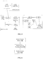
- Fig. 1 is a structure block diagram of a first system for statistics according to an embodiment in the present invention.
- a first system for statistics according to an embodiment in the present invention comprises a mobile terminal module 10 and a location-based service module 12.
- the mobile terminal module 10 is configured to send regularly location data thereof and time information corresponding to the location data to the location-based service module.
- the location data include but not limited to longitude and latitude coordinate location information.
- the location-based service module 12 is configured to obtain the navigation information based on statistics of the location data and corresponding time information thereof.
- the navigation information i.e. statistical data reflecting the popularity of popular locations, such as visitation volume, recommendation values, and/or rankings of the locations
- the navigation information obtained using the system provided in the above embodiment for obtaining navigation information is fair and reliable, does not have false content, and can provide quite precise navigation information to the mobile terminal users.
- the mobile terminal module may be a mobile terminal entity, and also may be one module provided on the mobile terminal; and the location-based service module may be an LBS server (location-based server) and also may be one module provided on the LBS server.
- LBS server location-based server
- the system may further comprise: a position service module 14 configured to receive regularly positioning requests of the mobile terminal module to position the mobile terminal module, and to send positioning results obtained upon operation to the mobile terminal module; and then the mobile terminal module is further configured to process the positioning results to obtain the location data.
- a position service module 14 configured to receive regularly positioning requests of the mobile terminal module to position the mobile terminal module, and to send positioning results obtained upon operation to the mobile terminal module; and then the mobile terminal module is further configured to process the positioning results to obtain the location data.
- the mobile terminal may be effectively positioned, and the location information of the mobile terminal is precisely obtained, so that the navigation information obtained is enabled to be precise and reliable.
- the positioning result includes but not limited to cellular Cell-ID, longitude and latitude coordinate data, etc.
- the mobile terminal module 10 may comprise: a GPS module 301 configured to send regularly the positioning request to the position service module and to receive the positioning result returned from the position service module; and a GPS switch module 302 configured to control on and off of the GPS module.
- a GPS module 301 configured to send regularly the positioning request to the position service module and to receive the positioning result returned from the position service module
- a GPS switch module 302 configured to control on and off of the GPS module.
- the privacy problem of the mobile terminal communication users and the problem of endurance capabilities of the mobile terminals also should be taken into consideration in the navigation method of performing statistics of the visitation number of a certain location based on the A-GPS positioning system. Therefore, it is quite necessary to add a GPS function switch.
- the GPS switching module refers to a switch set by a mobile communication terminal user for switching on the GPS function or not. Since frequent positioning will affect the endurance capability of a mobile terminal, and will cause privacy leakage of the mobile communication terminal user, a default setting of the GPS function switch is recommended to be "off". The GPS function switch is switched on initiatively when the mobile communication terminal user has a requirement in an aspect of location-based service.
- the mobile terminal module 10 may comprise: a storage module 308 configured to store the location data and corresponding time information thereof; and a delete module 307 configured to delete the location data and corresponding time information thereof when the location-based service module initiates a notification of having received the location data and corresponding time information thereof.
- the delete module refers to a method of the mobile terminal autonomously deleting various types of positioning data and statistics results after the mobile terminal receives a notification that a statistics result 1 returned from the LBS server has been received.
- the advantage of this method is that a part of the system resources can be regularly released.
- Fig. 2 is a structure block diagram of a mobile terminal in the first system for statistics according to a preferred embodiment in the present invention.
- the mobile terminal may further comprise the following modules: a GPS module 301 that sends the positioning request to the positioning server and receives the positioning result fed back from the positioning server; a GPS switch module 302 that is a switch autonomously operated by the mobile communication terminal user for controlling whether to turn on a GPS function or not; an operation module 303 that is a module which may make a cellular Cell-ID further precise to be longitude and latitude coordinates using an existing positioning technology, wherein the longitude and latitude coordinates are not necessarily a base station location of a cell corresponding to the Cell-ID, and may be further precise to be a location of the mobile terminal; a statistics module 304 (which includes therein the storage module 308 above) that is configured to perform statistics positioning results (longitude and latitude coordinate data) and corresponding time thereof, and to store the statistics results in a form of table, as specific examples seen in
- a send module 305 that sends the positioning results and corresponding time thereof stored in the form of Table 1 to an LBS server 200.
- a search module 306 that is connected to the network, in a manner such as GPRS, 3G, to search for popular location information, including but not limited to popular location visitation numbers determination values, recommendation values/ranking of popular type locations, etc., in which the mobile communication terminal users are interested;
- a delete module 307 that deletes autonomously various types of positioning data and statistics results stored on the mobile terminal after having received a notification that the positioning results returned from the LBS server 200 have been received.
- the position service module may be a positioning server entity.
- the position service module may further comprise: an A-GPS positioning server 101 that receives the positioning request from the mobile communication terminal user and returns corresponding positioning result; and a location calculation database 102 that operates and obtains current location information of the mobile terminal using an A-GPS general positioning technology, and feeds back an operating result to the A-GPS positioning server 101.
- an A-GPS positioning server 101 that receives the positioning request from the mobile communication terminal user and returns corresponding positioning result
- a location calculation database 102 that operates and obtains current location information of the mobile terminal using an A-GPS general positioning technology, and feeds back an operating result to the A-GPS positioning server 101.
- the location-based service module 14 may further comprise: a mapping module 203 configured to match in real-time collected location data with geographic information to determine popular locations; a statistics module 204 configured to perform statistics of visitation numbers of the popular locations in a temporal order, respectively; and a notification module 207 configured to send notification to the mobile terminal module when having received the location data and corresponding time information thereof.
- a mapping module 203 configured to match in real-time collected location data with geographic information to determine popular locations
- a statistics module 204 configured to perform statistics of visitation numbers of the popular locations in a temporal order, respectively
- a notification module 207 configured to send notification to the mobile terminal module when having received the location data and corresponding time information thereof.
- mapping above refers to matching the positioning data fed back from the mobile terminal with an electronic map and/or a thematic map in an LBS resource database.
- the geographic information above may be an electronic map provided by an LBS service provider, stored in the LBS resource database and dedicated to navigation to display various types of location information in which the users are interested, and specifically, such electronic map further may be divided into various types of "thematic maps" according to location information of various types. Of course, the electronic map will be updated regularly.
- Fig. 4 is a structure block diagram of a location-based service module in the first system for statistics according to a preferred embodiment in the present invention.
- the location-based service module may further comprise the following modules:
- triggering condition of a restaurant type location may be set to be 30 or 60 minutes; a triggering condition of a small shopping consumption type location may be set to be 10 or 15 minutes, while a triggering condition of a large shopping consumption type location may be set to be 1, 2 or 3 hours, etc.
- the above conditions are merely examples, and various types of triggering conditions may be set according to empirical values.
- the statistics module 204 may further comprise: a location information determination sub-module 2040, a judging sub-module 2042 and a statistics sub-module 2044.
- the location information determination sub-module 2040 is configured to mate up the longitude and latitude coordinates matched on the electronic map and/or thematic map with information of the popular locations on the map for determination, wherein the longitude and latitude coordinate data falling into the popular location range are determined as this popular location.
- the longitude and latitude coordinates, popular locations and corresponding time thereof are stored in a form of table, as specific examples seen in Table 2.
- the judging sub-module 2042 determines whether a time range from start to end of a mobile terminal in a certain popular location meets a triggering condition in a temporal order.
- the statistics sub-module 2044 is configured to add 1 to information of a popular location that meets a triggering condition.
- the judging sub-module 2042 makes a determination in a manner as follow.
- a popular location corresponding to a next time point is determined whether it is the same popular location; if yes, following popular locations are determined in turn in a temporal order until they are not the same popular location.
- a time range from start to end of the mobile terminal in this popular location is determined whether it meets a corresponding triggering condition, if yes, the statistics sub-module 2044 will add 1 to a visitation number of this popular location; and if they are not the same popular location, a new determination is restarted according to a location type of a current popular location.
- the determination manner described above may further includes: the judging sub-module 2042 firstly determining in a temporal order whether a popular location corresponding to a first time point in a present time period and a popular location corresponding to a last time point in a former time period are identical or not; if yes, a start time of this popular location is modified to be a start time determined in the former time period; and if not, a new determination is restarted.
- An analyze module 205 analyzes the visitation numbers of the popular locations determined and obtained to obtain recommendation values/ranking of locations of one popular type.
- An issue module 206 issues navigation information such as popular location visitation numbers and recommendation values/ranking of the popular type locations obtained upon a determination and analysis to the network to be searched by the mobile communication terminal users and other users.
- a notification module 207 sends notification to the mobile terminal module when having received the location data and corresponding time information thereof.
- Fig. 5 is a structure block diagram of the first system for statistics according to a preferred embodiment in the present invention.
- the first system for statistics according to a preferred embodiment in the present invention comprises: a positioning server 100, a mobile terminal 300, and an LBS server 200, wherein a GPS module of the mobile terminal 300 exchanges information with an A-GPS positioning server 101 of the positioning server 100, a search module 306 of the mobile terminal 300 may exchange information with an issue module of the LBS server 200, and a send module 305 of the mobile terminal 300 may exchange information with a receiving module 201 of the LBS server 200. See descriptions to Fig. 1 to Fig. 4 for working modes of the above modules combining with each other, and unnecessary details will not be given herein.
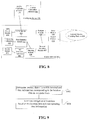
- Fig. 6 is a structure block diagram of a second system for statistics according to an embodiment in the present invention.
- the second system for statistics comprises: a mobile terminal module 60 and a network service provider module 62.
- the mobile terminal module 60 is configured to determine a popular location corresponding location data thereof and a visitation number of the popular location, and to report regularly obtained popular locations and visitation number thereof to the network service provider module.
- the location data include but not limited to longitude and latitude coordinate location information.
- the network service provider module 62 is configured to perform statistics of information of the popular locations and the visitation numbers thereof reported by the mobile terminal module to obtain the navigation information.
- the navigation information obtained using the system provided in the above embodiment for obtaining the navigation information is fair and reliable, does not have false content, and can provide quite precise navigation information to the mobile terminal users.
- the mobile terminal module may be a mobile terminal entity, and also may be one module provided on the mobile terminal; and the network service provider module may be a network service provider (such as www.dianping.com).
- the system may further comprise: a position service module 64 configured to receive regularly positioning requests from the mobile terminal module to position the mobile terminal module, and to send positioning results obtained upon operation to the mobile terminal module; and the mobile terminal module 60 is further configured to process the positioning results to obtain the location data.
- a position service module 64 configured to receive regularly positioning requests from the mobile terminal module to position the mobile terminal module, and to send positioning results obtained upon operation to the mobile terminal module; and the mobile terminal module 60 is further configured to process the positioning results to obtain the location data.
- the position service module 64 has a structure identical with the position service module 14, and may further comprise: an A-GPS positioning server 101 that receives positioning requests from a mobile communication terminal user, and returns corresponding positioning results; and a location calculation database 102 that operates and obtains current location information of the mobile terminal using an A-GPS general positioning technology and feeds back an operating result to the A-GPS positioning server 101.
- an A-GPS positioning server 101 that receives positioning requests from a mobile communication terminal user, and returns corresponding positioning results
- a location calculation database 102 that operates and obtains current location information of the mobile terminal using an A-GPS general positioning technology and feeds back an operating result to the A-GPS positioning server 101.
- the positioning result includes but not limited to cellular Cell-ID, longitude and latitude coordinate data, etc.
- the mobile terminal module 60 may comprise: a GPS module 401 configured to send regularly the positioning request to the position service module, and to receive the positioning result returned from the positioning server; and a GPS switching module 402 configured to control on and off of the GPS module.
- a GPS module 401 configured to send regularly the positioning request to the position service module, and to receive the positioning result returned from the positioning server
- a GPS switching module 402 configured to control on and off of the GPS module.
- the mobile terminal module 60 may comprise: a location-based service (LBS) resource data module 405 configured to store the location data and corresponding time information thereof; and a delete module 411 configured to delete regularly the location data and corresponding time information thereof.
- LBS location-based service
- the mobile terminal module 60 may comprise: a mapping module 406 configured to match in real-time collected location data with geographic information so as to determine popular locations; and a statistics module 407 configured to perform statistics of visitation numbers of popular locations in a temporal order, respectively.
- mapping above refers to matching the positioning data fed back from the mobile terminal with an electronic map and/or a thematic map in the LBS resource data module 405.
- the geographic information above may be an electronic map stored in the LBS resource data module 405 in the mobile terminal and dedicated to navigation to display various types of location information in which the users are interested, and specifically, such electronic map further may be divided into various types of "thematic maps" according to location information of various types. Of course, the electronic map will be updated regularly.
- Fig. 7 is a structure block diagram of a mobile terminal in a second system for statistics according to a preferred embodiment in the present invention. As shown in Fig. 7 , the mobile terminal in the second system for statistics may further comprise the following modules.
- the GPS module 401 sends positioning requests to a positioning server and receives positioning results fed back.
- the GPS module switch 402 is a switch autonomously operated by a mobile communication terminal user for controlling whether to turn on a GPS function.
- the operation module 403 refers to a module which may make a cellular Cell-ID further precise to be longitude and latitude coordinates using an existing positioning technology, wherein the longitude and latitude coordinates are not necessarily a base station location of a cell corresponding to the Cell-ID, and may be further precise to be a location of the mobile terminal.
- the statistics module 404 (which includes the storage module 412 above) is configured to perform statistics of positioning results (longitude and latitude coordinate data) and corresponding time thereof, and to store the statistics results in a form of table, as specific examples seen in Table 1.
- the LBS resource data module 405 stores various types of resource data, such as electronic map and/or thematic map, determining and analyzing data, and navigation information issued to the network, related to the location information and navigation information, and all the various types of resource data above are stored in a T-Flash card.
- resource data such as electronic map and/or thematic map, determining and analyzing data, and navigation information issued to the network, related to the location information and navigation information, and all the various types of resource data above are stored in a T-Flash card.
- the mapping module 406 matches the positioning data with the electronic map and/or thematic map in the LBS resource data module 405.
- the statistics module 407 regularly performs statistics of location information meeting triggering conditions in a temporal order, respectively, according to different triggering conditions (i.e., thresholds corresponding to types of the popular locations) corresponding to different types of location information.
- the statistics module 407 may further comprise a location information determination sub-module 4070, a judging sub-module 4072 and a statistics sub-module 4074.
- the location information determination sub-module 4070 is configured to match up the longitude and latitude coordinates found on the electronic map and/or thematic map with information of the popular locations on the map for determination, wherein the longitude and latitude coordinate data falling into the popular location range are determined as this popular location.
- the longitude and latitude coordinates, popular locations and corresponding time thereof are stored in a form of table, as specific examples seen in Table 2.
- the judging sub-module 4072 determines whether a time range from start to end of a mobile terminal in a certain popular location meets a triggering condition in a temporal order.
- the statistics sub-module 4074 is configured to add 1 to information of a popular location that meets a triggering condition.
- the judging sub-module 4072 makes a determination in a manner as follow: according to a location type of a popular location corresponding to a first time point, a popular location corresponding to a next time point is determined whether it is the same popular location; if yes, following popular locations are determined in turn in a temporal order until they are not the same popular location. At this time, a time range from start to end of the mobile terminal in this popular location is determined whether it meets a corresponding triggering condition, if yes, the statistics sub-module 4074 will add 1 to a visitation number of this popular location; and if they are not the same popular location, a new determination is restarted according to a location type of a current popular location.
- the determination manner above may further include: the judging sub-module 4072 firstly determining in a temporal order whether a popular location corresponding to a first time point in a present time period and a popular location corresponding to a last time point in a former time period are identical or not; if yes, a start time of this popular location is modified to be a start time determined in the former time period; and if not, a new determination is restarted.
- the analyze module 408 analyzes the visitation numbers of the popular locations determined and obtained to obtain recommendation values/ranking of locations of one popular type.
- the issue module 409 issues navigation information, such as popular location visitation numbers and recommendation values/ranking of the popular type locations, obtained upon a calculation and analysis to the network to be searched by the mobile communication terminal users.
- the search module 410 is connected to the network, in a manner such as GPRS, 3G, to search for popular location information, including but not limited to popular location visitation number statistics values, recommendation values/ranking of popular type locations, etc., in which the mobile communication terminal users are interested.
- the delete module 411 the mobile terminal autonomously eliminates regularly various types of positioning data and statistics results in the LBS resource data module 405.
- Fig. 8 is a structure block diagram of a second system for statistics according to a preferred embodiment in the present invention.
- the second system for statistics according to a preferred embodiment in the present invention comprises: a positioning server 100, a mobile terminal 300, and a network service providing platform 200, wherein, a GPS module 401 of the mobile terminal 300 exchanges information with an A-GPS positioning server 101 of the positioning server 100, and a search module 410 and an issue module 409 of the mobile terminal 300 exchange information with the network service providing platform 200, respectively. See descriptions to Fig. 5 to Fig. 7 for working modes of the above modules combining with each other, and unnecessary details will not be given herein.
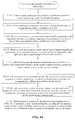
- Fig. 9 is a flow chart of a method for statistics of navigation information according to an embodiment in the present invention. As shown in Fig. 9 , a method for statistics of the navigation information may include the following processes:
- the navigation information obtained using the method provided in the above embodiment for obtaining the navigation information is fair and reliable, does not have false content, and can provide quite precise navigation information to the mobile communication terminal users, since the location data of the mobile terminal are determined regularly.
- step S902 above may further include the following processes:
- step S904 above may further include the following processes:
- positioning requests are sent continuously to the positioning server at a certain time interval, and the positioning server feeds back the positioning results obtained upon operation to the mobile terminal.
- the mobile terminal processes the positioning results returned and performs statistics of the data such as longitudinal and latitude coordinates obtained upon processing.
- the mobile terminal maps a statistics result 1 to an electronic map stored in the LBS resource data module of the mobile terminal, determines the mapping results regularly according to a certain condition, and issues a final statistics result 2 to the network for facilitating searching of the other mobile communication terminal users.
- the mobile terminal above has a GPS module that can position a current location of the mobile terminal via the positioning server, supports a T-Flash card and has a strong processing capability of mapping, performing statistics, analyzing and issuing, searching the positioning results on the mobile terminal.
- a working principle of the positioning server above refers to various positioning technologies that may be currently used in the location-based service technical fields such as positioning and navigating to obtain current location information of a mobile terminal.
- the time interval above may be set freely by a user, includes but not limited to 5 minutes, 10 minutes, 15 minutes, etc., but should not be shorter than shortest triggering time of all types of location information.
- the positioning result above includes but not limited to cellular Cell-ID, longitudinal and latitude coordinate data, etc.
- the statistics result 1 above refers to a set of data including positioning results (longitudinal and latitude coordinates) and corresponding time thereof, and the statistics results may be stored in a form of table, as seen specific examples in Table 1.
- the mapping above refers to the mobile terminal matching the positioning data with the electronic map and/or thematic map in the LBS resource data module.
- the LBS resource data module above refers to storing various types of resource data , such as electronic map and/or thematic map, statistics and analyzing data, and navigation information issued to the network, related to the location information and navigation information, and all the various types of resource data are stored in a T-Flash card.
- the electronic map above refers to an electronic map regularly updated by the LBS service provider or network and dedicated to navigation to display various types of location information in which the users are interested, and specifically, such electronic map further may be divided into various types of "thematic maps" according to location information of different types.
- a timing threshold of the timing above may be set freely by the user, for instance, 1 hour, 2 hours, 3 hours, 6 hours, etc.
- the certain conditions above correspond to different triggering conditions (i.e. thresholds corresponding to types of popular locations) according to the location information of different types.
- the statistics result 2 above refers to the mobile terminal determining (i.e. adding 1 to a visitation number of the location meeting a triggering condition) and analyzing the location information that meets the triggering condition to obtain recommendation values or ranking of locations of one popular type to be issued to the network to guide the mobile communication terminal users to obtain more convenient and fairer products and services.
- the analyzing method above may take factors such as age, sex and income of the mobile communication terminal users into consideration.
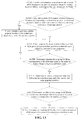
- Fig. 10 is a flow chart of a first method for statistics of navigation information according to a preferred embodiment in the present invention. As shown in Fig. 10 , a first method for obtaining the navigation information mainly includes the following processes:
- Step S1012 above mainly includes the following processes (step S1102-step S1116):
- the mobile terminal sends regularly the location data thereof and time information corresponding to the location data to the LBS server, and the LBS server performs statistics of the location data and corresponding time information thereof to obtain the navigation information.
- the visitation numbers of the popular locations can be updated in real-time via such a solution, and such statistics methodology is quite fair and reliable, does not have false content, and can provide quite precise navigation information to the mobile communication terminal users.
- step S904 above may further include the following processes:
- the mobile terminal when the GPS module of the mobile terminal is in a serving state, positioning requests are sent continuously to the positioning server at a certain time interval, and the positioning server feeds back the positioning results obtained upon operation to the mobile terminal.
- the mobile terminal processes the positioning results returned and performs statistics of the data such as longitudinal and latitude coordinates obtained upon processing.
- the mobile terminal maps a statistics result 1 to an electronic map stored in the LBS resource data module of the mobile terminal, determines regularly the mapping results according to a certain condition, and issues a final statistics result 2 of its own to the network (i.e. network service provider, also possibly called network service providing platform), and the network service provider may collect the statistics results reported from respective mobile terminals so as to facilitate searching by the other mobile communication terminal users.
- network service provider also possibly called network service providing platform
- Fig. 12 is a flow chart of a second method for statistics of navigation information according to a preferred embodiment in the present invention. As shown in Fig. 12 , a second method for obtaining the navigation information mainly includes:
- Step S1210 above mainly includes the following processes (step S 13 02-step S 1314):
- the mobile terminal provides regularly the statistics and analyzing results to the network service provider that obtains the navigation information above according to the data provided by respective mobile terminals.
- the visitation numbers of the popular locations can be updated in real-time via such a solution.
- Such statistics methodology is quite fair and reliable, does not have false content, and can provide quite precise navigation information to the mobile communication terminal users.
- each of the modules or steps in the present invention can be realized by the general determining apparatus, which can be collected in a single determining apparatus or distributed on the network formed by a plurality of determining apparatus.
- they can be realized by the program codes executable by the determining apparatus, therefore, they can be stored in the storing apparatus to be executed by the determining apparatus, and in some case the steps shown or described may be carried out in an order different from that herein, or they can be realized by fabricating them into integrated circuit modules, respectively, or a plurality of modules or steps therein are fabricated into individual integrated circuit module for accomplishment.
- the present invention is not limited to the combination of any particular hardware and software.
Landscapes
- Engineering & Computer Science (AREA)
- Radar, Positioning & Navigation (AREA)
- Remote Sensing (AREA)
- Physics & Mathematics (AREA)
- General Physics & Mathematics (AREA)
- Computer Networks & Wireless Communication (AREA)
- Business, Economics & Management (AREA)
- Databases & Information Systems (AREA)
- Theoretical Computer Science (AREA)
- Strategic Management (AREA)
- Development Economics (AREA)
- Accounting & Taxation (AREA)
- Finance (AREA)
- Signal Processing (AREA)
- Economics (AREA)
- General Business, Economics & Management (AREA)
- Marketing (AREA)
- Entrepreneurship & Innovation (AREA)
- Data Mining & Analysis (AREA)
- General Engineering & Computer Science (AREA)
- Game Theory and Decision Science (AREA)
- Mobile Radio Communication Systems (AREA)
- Position Fixing By Use Of Radio Waves (AREA)
- Navigation (AREA)
Description
- The present invention relates to the communication field, and in particular, to systems and methods for statistics of navigation information.
- At present, people would like to find from the Internet the recommendation information about various stores, especially about food and entertainment. For example, the websites such as www.52ch.net and www.dianping.com provide various types of consumer information, determine the visitation data of the stores, compile various evaluations, and publish portal websites of the best stores on a monthly or yearly basis. Such information compilation requires the consumers to register on the portal website before they can recommend, evaluate, etc. the stores. However, most people prefer only looking up consumer information, but not providing comments or reviews. Moreover, there are a lot of "sock puppets" on the portal websites, thus the visitation data and evaluations compiled from portal websites are not always fair or timely.
- Thus, conventionally the navigation information (i.e. statistical data reflecting the popularity visitation numbers of popular locations, such as visitation volume, recommendation values, and/or rankings of the locations) is determined completely based upon the information collected from the portal websites. This cannot meet the real-time requirement, and the information is not always fair. In addition, the more and more diversified requirements of the consumers to the navigation information cannot be satisfied. Therefore, how to improve the determination of the visitation volume of the popular locations so as to obtain fair and real-time navigation information to be searched by the mobile communication terminal users is an urgent problem to be solved.
-
US2010/0004997 discloses a system and method for generating a user profile based on periodic location fixes. - As to the problem in the prior art that the real-time requirement cannot be satisfied and the navigation information is not always fair since conventionally the navigation information is determined completely based upon the information collected on the portal websites, methods and systems for statistics of navigation information are provided in the present invention to solve at least one of the above problems.
- A system for statistics of navigation information is provided according to one aspect of the present invention.
- The system for statistics of navigation information according to the present invention comprises: a mobile terminal module configured to send regularly location data thereof and time information corresponding to the location data to a location-based service module; the location-based service module configured to obtain the navigation information based on statistics of the location data and corresponding time information thereof; a position service module configured to receive regularly positioning requests from the mobile terminal module to position the mobile terminal module, and to send positioning results obtained upon operation to the mobile terminal module; and the mobile terminal module is further configured to process the positioning results to obtain location data.
- Further, the mobile terminal module comprises: a GPS module configured to send regularly the positioning requests to the position service module and to receive the positioning results returned from the position service module; and a GPS switching module configured to control on and off of the GPS module.
- And further, the mobile terminal module comprises: a storage module configured to store the location data and corresponding time information thereto; and a delete module configured to delete the location data and corresponding time information thereof when the location-based service module initiates a notification of having received the location data and corresponding time information thereof.
- And further, the location-based service module comprises: a mapping module configured to match in real-time collected location data with geographic information to determine popular locations; a statistics module configured to perform statistics of visitation numbers of the popular locations in a temporal order, respectively; and a notification module configured to send notification to the mobile terminal module when having received the location data and corresponding time information thereof.
- A system for statistics of navigation information is provided according to another aspect of the present invention.
- The system for statistics of navigation information according to the present invention comprises: a mobile terminal module configured to determine popular locations corresponding to location data thereof and visitation numbers of the popular locations, and to report regularly the acquired popular locations and visitation numbers thereof to a network service providing module; the network service providing module configured to perform statistics of information of the popular locations and visitation numbers thereof reported from the mobile terminal module to obtain the navigation information; a position service module configured to receive regularly positioning requests from the mobile terminal module to position the mobile terminal module, and to send positioning results obtained upon operation to the mobile terminal module; and the mobile terminal module is further configured to process the positioning results to obtain the location data.
- And further, the mobile terminal module comprises: a GPS module configured to send regularly the positioning requests to the position service module and to receive the positioning results returned from the positioning server; and a GPS switching module configured to control on and off of the GPS module.
- And further, the mobile terminal module comprises: a location-based service resource data module configured to store the location data and corresponding time information thereof; and a delete module configured to delete regularly the location data and corresponding time information thereof.
- And further, the mobile terminal module comprises: a mapping module configured to match in real-time collected location data with geographic information to determine the popular locations; and a statistics module configured to perform statistics of visitation numbers of the popular locations in a temporal order, respectively.
- A method for statistics of navigation information is provided according to still another aspect of the present invention.
- The method for statistics of the navigation information according to the present invention comprising: determining regularly location data of a mobile terminal and time information corresponding to the location data; and determine the navigation information based on statistics of the location data and corresponding time information thereof
- Further, determining regularly the location data of the mobile terminal and the time information corresponding to the location data comprising: the mobile terminal sending regularly positioning requests to a positioning server; the positioning server positioning the mobile terminal and sending positioning results obtained upon operation to the mobile terminal; and the mobile terminal processing the positioning results to obtain the location data and reporting the same to a location-based server.
- And further, determine the navigation information based on statistics of the location data and corresponding time information thereof comprising: the location-based server matching in real-time collected location data with geographic information to determine popular locations; the location-based server performing statistics of visitation numbers of the popular locations in a temporal order, respectively; and the location-based server performing statistics of the navigation information based on the popular locations and the visitation numbers thereof
- And further, the location-based server performing statistics of the visitation numbers of the popular locations, respectively, comprising: the location-based server determining whether the mobile terminal stays at the popular locations longer than a threshold assigned to a type of locations including the popular locations; if yes, the location-based server adding 1 to the visitation numbers of the popular locations.
- And further, determine the navigation information based on statistics of the location data and corresponding time information thereof comprising: the mobile terminal matching in real-time the collected location data with geographic information to determine the popular locations; the mobile terminal performing statistics of visitation numbers of the popular locations in a temporal order, respectively; and the mobile terminal reporting regularly the popular locations and the visitation numbers thereof to a network service providing platform to enable the network service providing platform to determine the information reported from respective mobile terminals to obtain the navigation information.
- And further, the mobile terminal performing statistics of the visitation numbers of the popular locations, respectively, comprising: the mobile terminal determining whether the mobile terminal stays at the popular locations longer than a threshold assigned to a type of locations including the popular locations; if yes, the mobile terminal adding 1 to the visitation numbers of the popular locations.
- By the present invention, a positioning system is used to position a mobile terminal, and location data and corresponding time information thereof are determined to obtain navigation information, which solves the problem in the related art that the real-time requirement cannot be satisfied and calculating values are not always fair since conventionally the navigation information is determined completely based upon information collected on portal websites, and further, visitation numbers of popular locations may be updated in real-time, and such determination methodology is quite fair and reliable, does not have false content, and can provide quite precise navigation information to mobile communication terminal users.
- The drawings illustrated here provide a further understanding of the present invention and form a part of the present application. The exemplary embodiments and the description thereof are used to explain the present invention without unduly limiting the scope of the present invention, wherein:
-
Fig. 1 is a structure block diagram of a first system for statistics according to an embodiment in the present invention; -
Fig. 2 is a structure block diagram of a mobile terminal in the first system for statistics according to a preferred embodiment in the present invention; -
Fig. 3 is a structure block diagram of a position server in the first or a second system for statistics according to a preferred embodiment in the present invention; -
Fig. 4 is a structure block diagram of a location-based service module in the first system for statistics according to a preferred embodiment in the present invention; -
Fig. 5 is a structure block diagram of the first system for statistics according to a preferred embodiment in the present invention; -
Fig. 6 is a structure block diagram of the second system for statistics according to an embodiment in the present invention; -
Fig. 7 is a structure block diagram of a mobile terminal in the second system for statistics according to a preferred embodiment in the present invention; -
Fig. 8 is a structure block diagram of the second system for statistics according to a preferred embodiment in the present invention; -
Fig. 9 is a flow chart of a first method for statistics of navigation information according to an embodiment in the present invention; -
Fig. 10 is a flow chart of the first method for statistics of navigation information according to a preferred embodiment in the present invention; -
Fig. 11 is a flow chart of performing statistics by an LBS server (location-based server) according to a preferred embodiment in the present invention; -
Fig. 12 is a flow chart of a second method for statistics of navigation information according to a preferred embodiment in the present invention; and -
Fig. 13 is a flow chart of performing statistics by a mobile terminal according to a preferred embodiment in the present invention. - Next, the present invention will be illustrated in detail with reference to the accompanying drawings in conjunction with embodiments. It should be indicated that the embodiments and features therein in the present application can be combined with each other if they are not conflicted.
-
Fig. 1 is a structure block diagram of a first system for statistics according to an embodiment in the present invention. As shown inFig. 1 , a first system for statistics according to an embodiment in the present invention comprises amobile terminal module 10 and a location-basedservice module 12. - The
mobile terminal module 10 is configured to send regularly location data thereof and time information corresponding to the location data to the location-based service module. - Particularly, the location data include but not limited to longitude and latitude coordinate location information.
- The location-based
service module 12 is configured to obtain the navigation information based on statistics of the location data and corresponding time information thereof. - In related art, the navigation information (i.e. statistical data reflecting the popularity of popular locations, such as visitation volume, recommendation values, and/or rankings of the locations) is obtained completely based upon information collected on the portal websites. This cannot meet the real-time requirement, and the navigation information is not always fair; in addition, the more and more diversified requirements of the consumers to the navigation information cannot be satisfied. The navigation information obtained using the system provided in the above embodiment for obtaining navigation information is fair and reliable, does not have false content, and can provide quite precise navigation information to the mobile terminal users.
- Particularly, the mobile terminal module may be a mobile terminal entity, and also may be one module provided on the mobile terminal; and the location-based service module may be an LBS server (location-based server) and also may be one module provided on the LBS server.
- Preferably, the system may further comprise: a
position service module 14 configured to receive regularly positioning requests of the mobile terminal module to position the mobile terminal module, and to send positioning results obtained upon operation to the mobile terminal module; and then the mobile terminal module is further configured to process the positioning results to obtain the location data. - By the processing of the
position service module 14, the mobile terminal may be effectively positioned, and the location information of the mobile terminal is precisely obtained, so that the navigation information obtained is enabled to be precise and reliable. - Particularly, the positioning result includes but not limited to cellular Cell-ID, longitude and latitude coordinate data, etc.
- Preferably, as shown in
Fig. 2 , themobile terminal module 10 may comprise: aGPS module 301 configured to send regularly the positioning request to the position service module and to receive the positioning result returned from the position service module; and aGPS switch module 302 configured to control on and off of the GPS module. - Apart from the automatic determination of the visitation numbers, and fairness and convenience of the searching result, the privacy problem of the mobile terminal communication users and the problem of endurance capabilities of the mobile terminals also should be taken into consideration in the navigation method of performing statistics of the visitation number of a certain location based on the A-GPS positioning system. Therefore, it is quite necessary to add a GPS function switch.
- The GPS switching module refers to a switch set by a mobile communication terminal user for switching on the GPS function or not. Since frequent positioning will affect the endurance capability of a mobile terminal, and will cause privacy leakage of the mobile communication terminal user, a default setting of the GPS function switch is recommended to be "off". The GPS function switch is switched on initiatively when the mobile communication terminal user has a requirement in an aspect of location-based service.
- Preferably, as shown in
Fig. 2 , themobile terminal module 10 may comprise: a storage module 308 configured to store the location data and corresponding time information thereof; and adelete module 307 configured to delete the location data and corresponding time information thereof when the location-based service module initiates a notification of having received the location data and corresponding time information thereof. - In view of occupancy of mobile terminal system resources by endless positioning service and performing statistics, various types of positioning data and statistics results stored on the mobile terminal will be deleted once the statistics result is fed back to the LBS server.
- The delete module refers to a method of the mobile terminal autonomously deleting various types of positioning data and statistics results after the mobile terminal receives a notification that a
statistics result 1 returned from the LBS server has been received. The advantage of this method is that a part of the system resources can be regularly released. - Next, a preferred embodiment as mentioned above will be described in conjunction with
Fig. 2 . -
Fig. 2 is a structure block diagram of a mobile terminal in the first system for statistics according to a preferred embodiment in the present invention. As shown inFig. 2 , the mobile terminal may further comprise the following modules:
aGPS module 301 that sends the positioning request to the positioning server and receives the positioning result fed back from the positioning server;
aGPS switch module 302 that is a switch autonomously operated by the mobile communication terminal user for controlling whether to turn on a GPS function or not;
anoperation module 303 that is a module which may make a cellular Cell-ID further precise to be longitude and latitude coordinates using an existing positioning technology, wherein the longitude and latitude coordinates are not necessarily a base station location of a cell corresponding to the Cell-ID, and may be further precise to be a location of the mobile terminal;
a statistics module 304 (which includes therein the storage module 308 above) that is configured to perform statistics positioning results (longitude and latitude coordinate data) and corresponding time thereof, and to store the statistics results in a form of table, as specific examples seen in Table 1:Table 1 Longitude and Latitude Coordinates Time 1 (*, *) 09:00 2 (*, *) 09:05 3 (*, *) 09:10 4 ...... ......
asend module 305 that sends the positioning results and corresponding time thereof stored in the form of Table 1 to anLBS server 200.
asearch module 306 that is connected to the network, in a manner such as GPRS, 3G, to search for popular location information, including but not limited to popular location visitation numbers determination values, recommendation values/ranking of popular type locations, etc., in which the mobile communication terminal users are interested;
adelete module 307 that deletes autonomously various types of positioning data and statistics results stored on the mobile terminal after having received a notification that the positioning results returned from theLBS server 200 have been received. - Particularly, the position service module may be a positioning server entity.
- Preferably, as shown in
Fig. 3 , the position service module may further comprise: anA-GPS positioning server 101 that receives the positioning request from the mobile communication terminal user and returns corresponding positioning result; and alocation calculation database 102 that operates and obtains current location information of the mobile terminal using an A-GPS general positioning technology, and feeds back an operating result to theA-GPS positioning server 101. - Preferably, the location-based
service module 14 may further comprise: amapping module 203 configured to match in real-time collected location data with geographic information to determine popular locations; astatistics module 204 configured to perform statistics of visitation numbers of the popular locations in a temporal order, respectively; and anotification module 207 configured to send notification to the mobile terminal module when having received the location data and corresponding time information thereof. - Particularly, the mapping above refers to matching the positioning data fed back from the mobile terminal with an electronic map and/or a thematic map in an LBS resource database.
- Particularly, the geographic information above may be an electronic map provided by an LBS service provider, stored in the LBS resource database and dedicated to navigation to display various types of location information in which the users are interested, and specifically, such electronic map further may be divided into various types of "thematic maps" according to location information of various types. Of course, the electronic map will be updated regularly.
- Next, the preferred embodiment as mentioned above will be described in conjunction with
Fig. 4 . -
Fig. 4 is a structure block diagram of a location-based service module in the first system for statistics according to a preferred embodiment in the present invention. As shown inFig. 4 , the location-based service module may further comprise the following modules: - a
receiving module 201 that receives a statistics result related to the location information (i.e. the location data above) and fed back from the mobile terminal. - an
LBS resource database 202 that stores various types of resource data, such as electronic map and/or thematic map, determining and analyzing data, and navigation information issued to the network, related to the location information and navigation information; - a
mapping module 203 that matches (also maybe called "map") the positioning data fed back from the mobile terminal with the electronic map and/or thematic map in theLBS resource database 202; and - a
statistics module 204 that performs statistics of location information meeting triggering conditions in a temporal order, respectively, according to different triggering conditions (i.e. thresholds assigned to particular types of the popular locations) corresponding to different types of location information. - Particularly, different types of locations are assigned different triggering conditions, respectively. For instance, a triggering condition of a restaurant type location may be set to be 30 or 60 minutes; a triggering condition of a small shopping consumption type location may be set to be 10 or 15 minutes, while a triggering condition of a large shopping consumption type location may be set to be 1, 2 or 3 hours, etc. The above conditions of course are merely examples, and various types of triggering conditions may be set according to empirical values.
- In a preferred implementation process, the
statistics module 204 may further comprise: a locationinformation determination sub-module 2040, a judging sub-module 2042 and a statistics sub-module 2044. - The location
information determination sub-module 2040 is configured to mate up the longitude and latitude coordinates matched on the electronic map and/or thematic map with information of the popular locations on the map for determination, wherein the longitude and latitude coordinate data falling into the popular location range are determined as this popular location. The longitude and latitude coordinates, popular locations and corresponding time thereof are stored in a form of table, as specific examples seen in Table 2.Table 2 Popular Locations Longitude and Latitude Coordinates Time 1 Location 1 (*, *) 09:00 2 Location 1 (*, *) 09:05 3 Location 2 (*, *) 09:10 4 ...... ...... ...... - The judging sub-module 2042 determines whether a time range from start to end of a mobile terminal in a certain popular location meets a triggering condition in a temporal order.
- The statistics sub-module 2044 is configured to add 1 to information of a popular location that meets a triggering condition.
- In a preferred implementation process, the judging sub-module 2042 makes a determination in a manner as follow.
- According to a location type of a popular location corresponding to a first time point, a popular location corresponding to a next time point is determined whether it is the same popular location; if yes, following popular locations are determined in turn in a temporal order until they are not the same popular location. At this time, a time range from start to end of the mobile terminal in this popular location is determined whether it meets a corresponding triggering condition, if yes, the statistics sub-module 2044 will add 1 to a visitation number of this popular location; and if they are not the same popular location, a new determination is restarted according to a location type of a current popular location.
- In a preferred implementation process, the determination manner described above may further includes: the judging sub-module 2042 firstly determining in a temporal order whether a popular location corresponding to a first time point in a present time period and a popular location corresponding to a last time point in a former time period are identical or not; if yes, a start time of this popular location is modified to be a start time determined in the former time period; and if not, a new determination is restarted.
- An analyze
module 205 analyzes the visitation numbers of the popular locations determined and obtained to obtain recommendation values/ranking of locations of one popular type. - An
issue module 206 issues navigation information such as popular location visitation numbers and recommendation values/ranking of the popular type locations obtained upon a determination and analysis to the network to be searched by the mobile communication terminal users and other users. - A
notification module 207 sends notification to the mobile terminal module when having received the location data and corresponding time information thereof. - Next, the preferred embodiment as mentioned above will be described in conjunction with
Fig. 5 . -
Fig. 5 is a structure block diagram of the first system for statistics according to a preferred embodiment in the present invention. As shown inFig. 5 , the first system for statistics according to a preferred embodiment in the present invention comprises: a positioningserver 100, amobile terminal 300, and anLBS server 200, wherein a GPS module of themobile terminal 300 exchanges information with anA-GPS positioning server 101 of thepositioning server 100, asearch module 306 of themobile terminal 300 may exchange information with an issue module of theLBS server 200, and asend module 305 of themobile terminal 300 may exchange information with a receivingmodule 201 of theLBS server 200. See descriptions toFig. 1 to Fig. 4 for working modes of the above modules combining with each other, and unnecessary details will not be given herein. -
Fig. 6 is a structure block diagram of a second system for statistics according to an embodiment in the present invention. As shown inFig. 6 , the second system for statistics comprises: amobile terminal module 60 and a networkservice provider module 62. - The
mobile terminal module 60 is configured to determine a popular location corresponding location data thereof and a visitation number of the popular location, and to report regularly obtained popular locations and visitation number thereof to the network service provider module. - Particularly, the location data include but not limited to longitude and latitude coordinate location information.
- The network
service provider module 62 is configured to perform statistics of information of the popular locations and the visitation numbers thereof reported by the mobile terminal module to obtain the navigation information. - The navigation information obtained using the system provided in the above embodiment for obtaining the navigation information is fair and reliable, does not have false content, and can provide quite precise navigation information to the mobile terminal users.
- Particularly, the mobile terminal module may be a mobile terminal entity, and also may be one module provided on the mobile terminal; and the network service provider module may be a network service provider (such as www.dianping.com).
- Preferably, the system may further comprise: a
position service module 64 configured to receive regularly positioning requests from the mobile terminal module to position the mobile terminal module, and to send positioning results obtained upon operation to the mobile terminal module; and themobile terminal module 60 is further configured to process the positioning results to obtain the location data. - Preferably, as shown in
Fig. 3 , theposition service module 64 has a structure identical with theposition service module 14, and may further comprise: anA-GPS positioning server 101 that receives positioning requests from a mobile communication terminal user, and returns corresponding positioning results; and alocation calculation database 102 that operates and obtains current location information of the mobile terminal using an A-GPS general positioning technology and feeds back an operating result to theA-GPS positioning server 101. - Particularly, the positioning result includes but not limited to cellular Cell-ID, longitude and latitude coordinate data, etc.
- Preferably, as shown in
Fig. 7 , themobile terminal module 60 may comprise: aGPS module 401 configured to send regularly the positioning request to the position service module, and to receive the positioning result returned from the positioning server; and aGPS switching module 402 configured to control on and off of the GPS module. - Preferably, as shown in
Fig. 7 , themobile terminal module 60 may comprise: a location-based service (LBS)resource data module 405 configured to store the location data and corresponding time information thereof; and adelete module 411 configured to delete regularly the location data and corresponding time information thereof. - Preferably, as shown in
Fig. 7 , themobile terminal module 60 may comprise: amapping module 406 configured to match in real-time collected location data with geographic information so as to determine popular locations; and astatistics module 407 configured to perform statistics of visitation numbers of popular locations in a temporal order, respectively. - Particularly, the mapping above refers to matching the positioning data fed back from the mobile terminal with an electronic map and/or a thematic map in the LBS
resource data module 405. - Particularly, the geographic information above may be an electronic map stored in the LBS
resource data module 405 in the mobile terminal and dedicated to navigation to display various types of location information in which the users are interested, and specifically, such electronic map further may be divided into various types of "thematic maps" according to location information of various types. Of course, the electronic map will be updated regularly. - Next, the preferred embodiment as mentioned above will be described in conjunction with
Fig. 7 . -
Fig. 7 is a structure block diagram of a mobile terminal in a second system for statistics according to a preferred embodiment in the present invention. As shown inFig. 7 , the mobile terminal in the second system for statistics may further comprise the following modules. - The
GPS module 401 sends positioning requests to a positioning server and receives positioning results fed back. - The
GPS module switch 402 is a switch autonomously operated by a mobile communication terminal user for controlling whether to turn on a GPS function. - The
operation module 403 refers to a module which may make a cellular Cell-ID further precise to be longitude and latitude coordinates using an existing positioning technology, wherein the longitude and latitude coordinates are not necessarily a base station location of a cell corresponding to the Cell-ID, and may be further precise to be a location of the mobile terminal. - The statistics module 404 (which includes the storage module 412 above) is configured to perform statistics of positioning results (longitude and latitude coordinate data) and corresponding time thereof, and to store the statistics results in a form of table, as specific examples seen in Table 1.
- The LBS
resource data module 405 stores various types of resource data, such as electronic map and/or thematic map, determining and analyzing data, and navigation information issued to the network, related to the location information and navigation information, and all the various types of resource data above are stored in a T-Flash card. - The
mapping module 406 matches the positioning data with the electronic map and/or thematic map in the LBSresource data module 405. - The
statistics module 407 regularly performs statistics of location information meeting triggering conditions in a temporal order, respectively, according to different triggering conditions (i.e., thresholds corresponding to types of the popular locations) corresponding to different types of location information. - Preferably, the
statistics module 407 may further comprise a locationinformation determination sub-module 4070, a judging sub-module 4072 and a statistics sub-module 4074. - The location
information determination sub-module 4070 is configured to match up the longitude and latitude coordinates found on the electronic map and/or thematic map with information of the popular locations on the map for determination, wherein the longitude and latitude coordinate data falling into the popular location range are determined as this popular location. The longitude and latitude coordinates, popular locations and corresponding time thereof are stored in a form of table, as specific examples seen in Table 2. - The judging sub-module 4072 determines whether a time range from start to end of a mobile terminal in a certain popular location meets a triggering condition in a temporal order.
- The statistics sub-module 4074 is configured to add 1 to information of a popular location that meets a triggering condition.
- In a preferred implementation process, the judging sub-module 4072 makes a determination in a manner as follow: according to a location type of a popular location corresponding to a first time point, a popular location corresponding to a next time point is determined whether it is the same popular location; if yes, following popular locations are determined in turn in a temporal order until they are not the same popular location. At this time, a time range from start to end of the mobile terminal in this popular location is determined whether it meets a corresponding triggering condition, if yes, the statistics sub-module 4074 will add 1 to a visitation number of this popular location; and if they are not the same popular location, a new determination is restarted according to a location type of a current popular location.
- In a preferred implementation process, the determination manner above may further include: the judging sub-module 4072 firstly determining in a temporal order whether a popular location corresponding to a first time point in a present time period and a popular location corresponding to a last time point in a former time period are identical or not; if yes, a start time of this popular location is modified to be a start time determined in the former time period; and if not, a new determination is restarted.
- The analyze
module 408 analyzes the visitation numbers of the popular locations determined and obtained to obtain recommendation values/ranking of locations of one popular type. - The
issue module 409 issues navigation information, such as popular location visitation numbers and recommendation values/ranking of the popular type locations, obtained upon a calculation and analysis to the network to be searched by the mobile communication terminal users. - The
search module 410 is connected to the network, in a manner such as GPRS, 3G, to search for popular location information, including but not limited to popular location visitation number statistics values, recommendation values/ranking of popular type locations, etc., in which the mobile communication terminal users are interested. - The
delete module 411, the mobile terminal autonomously eliminates regularly various types of positioning data and statistics results in the LBSresource data module 405. - Next, the preferred embodiment as mentioned above will be described in conjunction with
Fig. 8 . -
Fig. 8 is a structure block diagram of a second system for statistics according to a preferred embodiment in the present invention. As shown inFig. 8 , the second system for statistics according to a preferred embodiment in the present invention comprises: a positioningserver 100, amobile terminal 300, and a networkservice providing platform 200, wherein, aGPS module 401 of themobile terminal 300 exchanges information with anA-GPS positioning server 101 of thepositioning server 100, and asearch module 410 and anissue module 409 of themobile terminal 300 exchange information with the networkservice providing platform 200, respectively. See descriptions toFig. 5 to Fig. 7 for working modes of the above modules combining with each other, and unnecessary details will not be given herein. -
Fig. 9 is a flow chart of a method for statistics of navigation information according to an embodiment in the present invention. As shown inFig. 9 , a method for statistics of the navigation information may include the following processes: - step S902: determining regularly location data of a mobile terminal and time information corresponding to the location data; and
- step S904: determining the navigation information based on statistics of the location data and corresponding time information thereof.
- The navigation information obtained using the method provided in the above embodiment for obtaining the navigation information is fair and reliable, does not have false content, and can provide quite precise navigation information to the mobile communication terminal users, since the location data of the mobile terminal are determined regularly.
- There are mainly the following two preferred embodiments as to the method for obtaining the navigation information.
- Firstly, a first embodiment is described.
- Preferably, step S902 above may further include the following processes:
- (1) a mobile terminal sends regularly positioning requests to a positioning server;
- (2) the positioning server positions the mobile terminal and sends positioning results obtained upon operation to the mobile terminal; and
- (3) the mobile terminal processes the positioning result to obtain the location data and reports the same to the location-based server.
- Preferably, step S904 above may further include the following processes:
- (1) the location-based server matches regularly collected location data with geographic information to determine popular locations;
- (2) the location-based server determines in a temporal order visitation numbers of popular locations, respectively;
in a preferred implementation process, the location-based server performing statistics respectively of the visitation numbers of the popular locations includes: the location-based server determining whether duration of a mobile terminal in a popular location is longer than a threshold corresponding to a type of the popular location; if yes, the location-based server adding 1 to the visitation number of the popular location; and - (3) the location-based server obtains the navigation information based on the statistics of the popular locations and the visitation numbers thereof
- Next, this embodiment will be described in detail in conjunction with an example.
- In a specific implementing embodiment, when the GPS module of the mobile terminal is in a serving state, positioning requests are sent continuously to the positioning server at a certain time interval, and the positioning server feeds back the positioning results obtained upon operation to the mobile terminal. The mobile terminal processes the positioning results returned and performs statistics of the data such as longitudinal and latitude coordinates obtained upon processing. The mobile terminal maps a
statistics result 1 to an electronic map stored in the LBS resource data module of the mobile terminal, determines the mapping results regularly according to a certain condition, and issues a final statistics result 2 to the network for facilitating searching of the other mobile communication terminal users. - The mobile terminal above has a GPS module that can position a current location of the mobile terminal via the positioning server, supports a T-Flash card and has a strong processing capability of mapping, performing statistics, analyzing and issuing, searching the positioning results on the mobile terminal.
- A working principle of the positioning server above refers to various positioning technologies that may be currently used in the location-based service technical fields such as positioning and navigating to obtain current location information of a mobile terminal.
- The time interval above may be set freely by a user, includes but not limited to 5 minutes, 10 minutes, 15 minutes, etc., but should not be shorter than shortest triggering time of all types of location information.
- The positioning result above includes but not limited to cellular Cell-ID, longitudinal and latitude coordinate data, etc.
- The statistics result 1 above refers to a set of data including positioning results (longitudinal and latitude coordinates) and corresponding time thereof, and the statistics results may be stored in a form of table, as seen specific examples in Table 1.
- The mapping above refers to the mobile terminal matching the positioning data with the electronic map and/or thematic map in the LBS resource data module.
- The LBS resource data module above refers to storing various types of resource data , such as electronic map and/or thematic map, statistics and analyzing data, and navigation information issued to the network, related to the location information and navigation information, and all the various types of resource data are stored in a T-Flash card.
- The electronic map above refers to an electronic map regularly updated by the LBS service provider or network and dedicated to navigation to display various types of location information in which the users are interested, and specifically, such electronic map further may be divided into various types of "thematic maps" according to location information of different types.
- A timing threshold of the timing above may be set freely by the user, for instance, 1 hour, 2 hours, 3 hours, 6 hours, etc.
- The certain conditions above correspond to different triggering conditions (i.e. thresholds corresponding to types of popular locations) according to the location information of different types.
- The statistics result 2 above refers to the mobile terminal determining (i.e. adding 1 to a visitation number of the location meeting a triggering condition) and analyzing the location information that meets the triggering condition to obtain recommendation values or ranking of locations of one popular type to be issued to the network to guide the mobile communication terminal users to obtain more convenient and fairer products and services. Particularly, the analyzing method above may take factors such as age, sex and income of the mobile communication terminal users into consideration.
-
Fig. 10 is a flow chart of a first method for statistics of navigation information according to a preferred embodiment in the present invention. As shown inFig. 10 , a first method for obtaining the navigation information mainly includes the following processes: - step S1002: a
GPS switch module 302 controlling to switch on aGPS module 301 that sends positioning requests to apositioning server 100 and receives positioning results fed back from thepositioning server 100; - step S1004: an
operation module 303 processing the positioning results fed back and presenting the same as longitudinal and latitude coordinates uniformly; - step S1006: a
statistics module 304 storing statistics results of positioning (longitudinal and latitude coordinate data) and corresponding time thereof in a form of Table 1, and sending the same to anLBS server 200 via asend module 305; - step S1008: after having received a notification returned from the
LBS server 200 that the positioning results have been received, adelete module 307 eliminating autonomously various types of positioning data and statistics results stored on themobile terminal 300; - step S1010: a
mapping module 203 of theLBS server 200 matching the statistics results related to the location information, received by a receivingmodule 201 and fed back from themobile terminal 300 with an electronic map and/or thematic map in anLBS resource database 202; and - step S1012: the
statistics module 204 performing statistics of location information meeting triggering conditions in a temporal order, respectively, according to different triggering conditions corresponding to different types of location information; - The preferred embodiment as mentioned above will be described in conjunction with
Fig. 11 . Step S1012 above mainly includes the following processes (step S1102-step S1116): - step S1102: the
mobile terminal 300 sending regularly the positioning results and corresponding time thereof in this time period to theLBS server 200; - step S1104: a location
information determination sub-module 2040 determining popular locations where the mobile terminal is positioned in this time period, and storing data after determination in a form of Table 2; - step S1106: a judging sub-module 2042 determining whether a popular location corresponding to a first time point is identical with a popular location corresponding to a last time point in a former time period;
- step S1108: if yes, modifying a start time of this popular location to be a start time of statistics in the former time period; and if not, taking a popular location corresponding to a first time point in a present time period as a start of a determination, and restarting a new determination;
- step S 1110: determining whether the popular location corresponding to the first time point and a popular location corresponding to a next time point are the same popular location; if yes, carrying out step S 1112; otherwise, returning to carry out step S1108, and restarting a new determination according to a location type of a current popular location;
- step S 1112: if they are the same popular location, determining following popular locations in turn in a temporal order until they are not the same popular location;
- step S1114: determining whether a time range from start to end of the
mobile terminal 300 in this popular location meets a corresponding triggering condition; and - step S1116: the statistics sub-module 2044 adding 1 to a visitation number of this popular location if a triggering condition is met.
- step S1014: an analyzing
module 205 analyzing the obtained statistics of visitation numbers of popular locations to obtain recommendation values/ranking of locations of one popular type, and anissuing module 206 issuing the visitation numbers of locations and recommendation value/ranking of the popular type locations obtained from the statistics and analysis to the network to be searched by the mobile communication terminal users; and - step S1016: connecting a
search module 306 to the network, in a manner such as GPRS, 3G, to search for popular location information, including popular location visitation numbers, recommendation values/ranking of the popular type locations, etc., in which the mobile communication terminal users are interested. - With the above embodiment, the mobile terminal sends regularly the location data thereof and time information corresponding to the location data to the LBS server, and the LBS server performs statistics of the location data and corresponding time information thereof to obtain the navigation information. The visitation numbers of the popular locations can be updated in real-time via such a solution, and such statistics methodology is quite fair and reliable, does not have false content, and can provide quite precise navigation information to the mobile communication terminal users.
- Secondly, a second embodiment is described.
- Preferably, step S904 above may further include the following processes:
- (1) the mobile terminal matches in real the collected location data with geographic information to determine popular locations;
- (2) the mobile terminal performs statistics of visitation numbers of the popular locations in a temporal order, respectively;
in a preferred implementation process, the step above may include the following processes: the mobile terminal determining whether duration thereof in a popular location is longer than a threshold corresponding to a type of the popular location; if yes, the mobile terminal adding 1 to the visitation numbers of the popular locations, respectively; and - (3) the mobile terminal reports regularly the popular locations and the visitation numbers thereof to the network service providing platform to enable the network service providing platform to perform statistics of the information reported from respective mobile terminals to obtain the navigation information.
- Next, the embodiment will be described in detail in conjunction with an example.
- In a specific implementation process, when the GPS module of the mobile terminal is in a serving state, positioning requests are sent continuously to the positioning server at a certain time interval, and the positioning server feeds back the positioning results obtained upon operation to the mobile terminal. The mobile terminal processes the positioning results returned and performs statistics of the data such as longitudinal and latitude coordinates obtained upon processing. The mobile terminal maps a
statistics result 1 to an electronic map stored in the LBS resource data module of the mobile terminal, determines regularly the mapping results according to a certain condition, and issues a final statistics result 2 of its own to the network (i.e. network service provider, also possibly called network service providing platform), and the network service provider may collect the statistics results reported from respective mobile terminals so as to facilitate searching by the other mobile communication terminal users. - Particularly, all the concepts such as the mobile terminal, the working principle of the positioning server, the time interval, the positioning result, statistics result 1, and statistics result 2 have been described, and unnecessary details will not be given herein.
-
Fig. 12 is a flow chart of a second method for statistics of navigation information according to a preferred embodiment in the present invention. As shown inFig. 12 , a second method for obtaining the navigation information mainly includes: - step S1202: a
GPS switching module 402 controlling to switch on aGPS module 401 that sends positioning requests to apositioning server 100 and receiving positioning results fed back from thepositioning server 100; - step S1204: an
operation module 403 processing the positioning results fed back and presenting the same as longitudinal and latitude coordinates uniformly; - step S1206: a
statistics module 404 storing statistics results of positioning (longitudinal and latitude coordinate data) and corresponding time thereof in a form of Table 1; - step S1208: a
mapping module 406 matching the positioning data with an electronic map and/or thematic map in the LBSresource data module 405; and - step S1210: a
statistics module 407 regularly performing statistics of location information meeting triggering conditions in a temporal order, respectively, according to different triggering conditions corresponding to different types of location information. - The preferred embodiment as mentioned above will be described in conjunction with
Fig. 13 . Step S1210 above mainly includes the following processes (step S 13 02-step S 1314): - step S1302: a location
information determination sub-module 4070 determining popular locations where the mobile terminal is positiond in this time period, and storing data after determination in a form of Table 2; - step S1304: a judging sub-module 4072 determining whether a popular location corresponding to a first time point in a present time period is identical with a popular location corresponding to a last time point in a former time period;
- step S1306: if yes, modifying a start time of this popular location to be a start time determined in the former time period; and if not, taking a popular location corresponding to a first time point in a present time period as a start of a determination, and restarting a new determination;
- step S1308: determining whether the popular location corresponding to the first time point and a popular location corresponding to a next time point are the same popular location; if not, restarting a new determination according to a location type of a current popular location;
- step S1310: if they are the same popular location, determining following popular locations in turn in a temporal order until they are not the same popular location;
- step S 1312: at this time, determining whether a time range from start to end of the
mobile terminal 400 in this popular location meets a corresponding triggering condition; - step S 1314: the statistics sub-module 4074 adding 1 to a visitation number of this popular location if a triggering condition is met;
- step S1212: an analyze
module 408 analyzing the obtained statistics of popular location visitation numbers and anissue module 409 issuing the analyzing result to the network service provider that obtains the navigation information according to the analyzing results provided by respective mobile terminals to be searched by the mobile communication terminal users; - step S1214: connecting a
search module 410 to the network, in a manner such as GPRS, 3G, to search for popular location information, comprising but not limited to statistics of popular location visitation number, recommendation values/ranking of the popular type locations, etc., in which the mobile communication terminal users are interested; and - step S1216: a
delete module 411 eliminating regularly and autonomously various types of positioning data and statistics results in the LBSresource data module 405. - With the above embodiment, the mobile terminal provides regularly the statistics and analyzing results to the network service provider that obtains the navigation information above according to the data provided by respective mobile terminals. The visitation numbers of the popular locations can be updated in real-time via such a solution. Such statistics methodology is quite fair and reliable, does not have false content, and can provide quite precise navigation information to the mobile communication terminal users.
- To sum up, both technical solutions above provided in the present invention can realize real-time updating of the visitation numbers of the popular locations, and such statistics methodologies are quite fair and reliable, do not have false content, and can provide quite precise navigation information to the mobile communication terminal users.
- Apparently, the person skilled in the art should know that each of the modules or steps in the present invention can be realized by the general determining apparatus, which can be collected in a single determining apparatus or distributed on the network formed by a plurality of determining apparatus. Optionally, they can be realized by the program codes executable by the determining apparatus, therefore, they can be stored in the storing apparatus to be executed by the determining apparatus, and in some case the steps shown or described may be carried out in an order different from that herein, or they can be realized by fabricating them into integrated circuit modules, respectively, or a plurality of modules or steps therein are fabricated into individual integrated circuit module for accomplishment. Thus, the present invention is not limited to the combination of any particular hardware and software.
- The above mentioned is merely the preferred embodiments of the present invention but not to limit the present invention. Various alterations and changes to the present invention are apparent to the person skilled in the art. Any modifications, equivalent substitutions, improvements etc. within the spirit and principle of the present invention should be concluded in the scope protected by the present invention.
Claims (13)
- A mobile terminal module (60), configured to determine popular locations corresponding to location data thereof and visitation numbers of the popular locations, and to report regularly the determined popular locations and visitation numbers thereof to a network service providing module, characterized by comprising:a mapping module (406) configured to match in real-time collected location data with geographic information to determine the popular locations;a statistics module (407) configured to perform statistics of visitation numbers of the popular locations in a temporal order, respectively;an analyze module (408) configured to analyze the visitation numbers of the popular locations and obtain navigation information; andan issue module (409) configured to issue navigation information to the network to be searched by the mobile communication terminal users.
- The mobile terminal module (60) according to Claim 1, characterized in that the mobile terminal module comprises:a GPS module (401) configured to send regularly positioning requests to a position service module (64) and to receive positioning results returned from the position service module; anda GPS switching module (402) configured to control on and off of the GPS module (401).
- The mobile terminal module (60) according to Claim 1, characterized in that the mobile terminal module (60) comprises:a location-based service resource data module (405) configured to store the location data and corresponding time information thereof; anda delete module (307) configured to delete the location data and corresponding time information thereof regularly.
- A system for statistics of navigation information, characterized by comprising:a mobile terminal module (60) configured to determine popular locations corresponding to location data thereof and visitation numbers of the popular locations, and to report regularly the determined popular locations and visitation numbers thereof to a network service providing module;the network service providing module (62) configured to perform statistics of information of the popular locations and visitation numbers thereof reported from the mobile terminal module to obtain the navigation information;a position service module (64) configured to receive regularly positioning requests from the mobile terminal module to position the mobile terminal module, and to send positioning results obtained upon operation to the mobile terminal module; andthe mobile terminal module (60) being further configured to process the positioning results to obtain the location data,wherein the mobile terminal module (60) comprises:a mapping module (406) configured to match in real-time collected location data with geographic information to determine the popular locations;a statistics module (407) configured to perform statistics of visitation numbers of the popular locations in a temporal order, respectively;an analyze module (408) configured to analyze the visitation numbers of the popular locations and obtain navigation information; andan issue module (409) configured to issue navigation information to the network to be searched by the mobile communication terminal users.
- The system according to Claim 4, characterized in that the mobile terminal module (400) comprises:a GPS module (401) configured to send regularly positioning requests to a position service module and to receive positioning results returned from the position service module; anda GPS switching module (402) configured to control on and off of the GPS module.
- The system according to Claim 4, characterized in that the mobile terminal module (400) comprises:a location-based service resource data module (405) configured to store the location data and corresponding time information thereof; anda delete module (411) configured to delete regularly the location data and corresponding time information thereof.
- A method for statistics of navigation information, characterized by comprising:performing following process in a mobile terminal module: determining popular locations corresponding to the location data thereof and visitation numbers of the popular locations, and reporting regularly the determined popular locations and visitation numbers thereof to a network service providing module; andperforming following process in a network service providing module: performing statistics of information of the popular locations and visitation numbers thereof reported from the mobile terminal module to obtain the navigation information, whereinthe determining and reporting process in the mobile terminal module comprise following steps:matching in real-time collected location data with geographic information to determine the popular locations;performing statistics of visitation numbers of the popular locations in a temporal order, respectively;analyzing the visitation numbers of the popular locations and obtain navigation information; andissuing navigation information to the network to be searched by the mobile communication terminal users.
- The method according to Claim 7, characterized in that the steps operated in the mobile terminal further comprise:sending regularly positioning requests to a position service module and receiving positioning results returned from the position service module; andprocessing the received positioning results and presenting the same as longitudinal and latitude coordinates uniformly.
- The method according to Claim 7, characterized in that steps operated in the mobile terminal further comprise:storing statistics results of positioning and corresponding time thereof in a form of a table wherein the results of positioning are in a form of longitudinal and latitude coordinate data respectively.
- The method according to Claim 9, characterized in that the steps operated in the mobile terminal further comprise:analyzing the obtained statistics of popular location visitation numbers and issuing the analyzing result to the network service provider that obtains the navigation information according to the analyzing results provided by respective mobile terminals to be searched by the mobile communication terminal users.
- The method according to Claim 7, characterized in that the steps operated in the mobile terminal further comprise:regularly performing statistics of location information meeting triggering conditions in a temporal order, respectively, according to different triggering conditions corresponding to different types of location information.
- The method according to Claim 11, characterized in that the step of regularly performing statistics of location information further comprises:determining whether a popular location corresponding to a first time point in a present time period is identical with a popular location corresponding to a last time point in a former time period;if yes, modifying a start time of this popular location to be a start time determined in the former time period; and if not, taking a popular location corresponding to a first time point in a present time period as a start of a determination, and restarting a new determination.
- The method according to Claim 12, characterized in that the step of regularly performing statistics of location information further comprises:determining whether the popular location corresponding to the first time point and a popular location corresponding to a next time point are the same popular location;if not, restarting a new determination according to a location type of a current popular location; if they are the same popular location, determining following popular locations in turn in a temporal order until they are not the same popular location.
Applications Claiming Priority (2)
| Application Number | Priority Date | Filing Date | Title |
|---|---|---|---|
| CN2010102251379A CN101902688A (en) | 2010-07-09 | 2010-07-09 | Counting and acquiring system and method of navigation information |
| PCT/CN2010/077910 WO2012003679A1 (en) | 2010-07-09 | 2010-10-20 | System and method for acquiring statistics of navigation information |
Publications (3)
| Publication Number | Publication Date |
|---|---|
| EP2592885A1 EP2592885A1 (en) | 2013-05-15 |
| EP2592885A4 EP2592885A4 (en) | 2014-03-12 |
| EP2592885B1 true EP2592885B1 (en) | 2016-05-04 |
Family
ID=43227816
Family Applications (1)
| Application Number | Title | Priority Date | Filing Date |
|---|---|---|---|
| EP10854338.0A Not-in-force EP2592885B1 (en) | 2010-07-09 | 2010-10-20 | System and method for acquiring statistics of navigation information |
Country Status (4)
| Country | Link |
|---|---|
| US (1) | US20120215438A1 (en) |
| EP (1) | EP2592885B1 (en) |
| CN (1) | CN101902688A (en) |
| WO (1) | WO2012003679A1 (en) |
Families Citing this family (19)
| Publication number | Priority date | Publication date | Assignee | Title |
|---|---|---|---|---|
| US8644844B2 (en) | 2007-12-20 | 2014-02-04 | Corning Mobileaccess Ltd. | Extending outdoor location based services and applications into enclosed areas |
| US9590733B2 (en) | 2009-07-24 | 2017-03-07 | Corning Optical Communications LLC | Location tracking using fiber optic array cables and related systems and methods |
| WO2011123336A1 (en) | 2010-03-31 | 2011-10-06 | Corning Cable Systems Llc | Localization services in optical fiber-based distributed communications components and systems, and related methods |
| US8570914B2 (en) | 2010-08-09 | 2013-10-29 | Corning Cable Systems Llc | Apparatuses, systems, and methods for determining location of a mobile device(s) in a distributed antenna system(s) |
| EP2702710A4 (en) | 2011-04-29 | 2014-10-29 | Corning Cable Sys Llc | Determining propagation delay of communications in distributed antenna systems, and related components, systems and methods |
| CN102831113B (en) * | 2011-06-14 | 2015-10-21 | 腾讯科技(深圳)有限公司 | Positional information sharing method and system |
| KR20140067108A (en) * | 2011-09-12 | 2014-06-03 | 콘티넨탈 테베스 아게 운트 코. 오하게 | Time-corrected sensor system |
| US9781553B2 (en) | 2012-04-24 | 2017-10-03 | Corning Optical Communications LLC | Location based services in a distributed communication system, and related components and methods |
| WO2013181247A1 (en) | 2012-05-29 | 2013-12-05 | Corning Cable Systems Llc | Ultrasound-based localization of client devices with inertial navigation supplement in distributed communication systems and related devices and methods |
| CN102905363B (en) * | 2012-07-20 | 2014-12-03 | 北京邮电大学 | Factor graph based positioning method |
| US9158864B2 (en) | 2012-12-21 | 2015-10-13 | Corning Optical Communications Wireless Ltd | Systems, methods, and devices for documenting a location of installed equipment |
| US20140316691A1 (en) * | 2013-04-23 | 2014-10-23 | Xiaomi Inc. | Method and terminal for providing electronic map |
| US9077321B2 (en) | 2013-10-23 | 2015-07-07 | Corning Optical Communications Wireless Ltd. | Variable amplitude signal generators for generating a sinusoidal signal having limited direct current (DC) offset variation, and related devices, systems, and methods |
| GB201400601D0 (en) * | 2014-01-14 | 2014-03-05 | Tomtom Int Bv | Apparatus and method for a probe data management |
| US9648580B1 (en) | 2016-03-23 | 2017-05-09 | Corning Optical Communications Wireless Ltd | Identifying remote units in a wireless distribution system (WDS) based on assigned unique temporal delay patterns |
| CN106778436A (en) * | 2016-12-10 | 2017-05-31 | 福建四创软件有限公司 | mobile inspection system and method based on variable two-dimension code scanning and circulation of official document |
| ES2922650T3 (en) * | 2017-01-17 | 2022-09-19 | Tutela Tech Ltd | System and procedure for evaluating the performance of wireless devices and wireless networks |
| US10945096B2 (en) * | 2017-02-17 | 2021-03-09 | DataSpark, PTE. LTD. | Mobility gene for visit data |
| CN108827285B (en) * | 2018-06-29 | 2021-05-11 | 绍兴东巍体育科技有限公司 | Juvenile health data sharing system and method based on smart band |
Family Cites Families (6)
| Publication number | Priority date | Publication date | Assignee | Title |
|---|---|---|---|---|
| DE19819582A1 (en) * | 1998-04-30 | 1999-11-04 | Siemens Ag | Location-dependent implementation of services of a cellular network |
| US6831563B1 (en) * | 2001-03-20 | 2004-12-14 | Bellsouth Intellectual Property Corp. | Location visit confirmation services for wireless devices |
| US6847824B1 (en) * | 2001-03-20 | 2005-01-25 | Bellsouth Intellectual Property Corp. | Location visit detail services for wireless devices |
| CN101557582B (en) * | 2008-04-08 | 2012-08-29 | 中国移动通信集团公司 | Method and device for mobile communication user information statistics |
| US9646025B2 (en) * | 2008-05-27 | 2017-05-09 | Qualcomm Incorporated | Method and apparatus for aggregating and presenting data associated with geographic locations |
| US10163113B2 (en) * | 2008-05-27 | 2018-12-25 | Qualcomm Incorporated | Methods and apparatus for generating user profile based on periodic location fixes |
-
2010
- 2010-07-09 CN CN2010102251379A patent/CN101902688A/en active Pending
- 2010-10-20 EP EP10854338.0A patent/EP2592885B1/en not_active Not-in-force
- 2010-10-20 WO PCT/CN2010/077910 patent/WO2012003679A1/en active Application Filing
- 2010-10-20 US US13/258,999 patent/US20120215438A1/en not_active Abandoned
Also Published As
| Publication number | Publication date |
|---|---|
| EP2592885A4 (en) | 2014-03-12 |
| US20120215438A1 (en) | 2012-08-23 |
| WO2012003679A1 (en) | 2012-01-12 |
| EP2592885A1 (en) | 2013-05-15 |
| CN101902688A (en) | 2010-12-01 |
Similar Documents
| Publication | Publication Date | Title |
|---|---|---|
| EP2592885B1 (en) | System and method for acquiring statistics of navigation information | |
| US20220156252A1 (en) | System and method for data collection to validate location data | |
| CN106209935B (en) | Information processing method, terminal and server | |
| CN108848022A (en) | A kind of information push method based on scene and user behavior | |
| US20170325071A1 (en) | Method and device for displaying information which links to related information provided by user's friends at user's location | |
| WO2015184431A1 (en) | System and process for location-based informationretrieval | |
| RU2569572C2 (en) | Method and system for displaying user activities based on geographic location information and computer storage medium therefor | |
| CN105008858A (en) | User-in-the-loop architecture for indoor positioning | |
| CN104408043A (en) | Information processing method and server | |
| WO2018166280A1 (en) | Information recommendation method, apparatus, system, and storage medium | |
| CN106850106B (en) | Radio environment map data collection system and method based on mobile crowd sensing | |
| CN108023924A (en) | A kind of information processing method, terminal and server | |
| CN104717526A (en) | Multimedia data pushing method and device | |
| CN105072169A (en) | Intelligent information display system of culture exhibition hall | |
| EP3007072A1 (en) | Method for displaying site page related to current position in desired condition order in portable terminal, and system | |
| KR101331767B1 (en) | System and method for providing mobile local social service based on real-time location information, and computer-readable recording medium for the same | |
| US20230153364A1 (en) | Information processing apparatus and method | |
| KR101646166B1 (en) | System and method for providing map sharing services for location information sharing | |
| CN101753628A (en) | Method for reception and transmission of positioning service active information and portable electronic device thereof | |
| CN103874014A (en) | Terminal location information-based business service method, service provision device and terminal | |
| CN105066987A (en) | GPS navigation system based on Android platform | |
| CN110602199A (en) | Data acquisition method and system of application program, intelligent terminal and storage medium | |
| CN105704330B (en) | A kind of message registration management method and device | |
| KR20170059716A (en) | Voice calls only System that can provide real-time location information And Way | |
| CN105827721B (en) | A kind of data transmission method and device |
Legal Events
| Date | Code | Title | Description |
|---|---|---|---|
| PUAI | Public reference made under article 153(3) epc to a published international application that has entered the european phase |
Free format text: ORIGINAL CODE: 0009012 |
|
| 17P | Request for examination filed |
Effective date: 20120329 |
|
| AK | Designated contracting states |
Kind code of ref document: A1 Designated state(s): AL AT BE BG CH CY CZ DE DK EE ES FI FR GB GR HR HU IE IS IT LI LT LU LV MC MK MT NL NO PL PT RO RS SE SI SK SM TR |
|
| DAX | Request for extension of the european patent (deleted) | ||
| A4 | Supplementary search report drawn up and despatched |
Effective date: 20140212 |
|
| RIC1 | Information provided on ipc code assigned before grant |
Ipc: H04W 4/20 20090101ALI20140206BHEP Ipc: G06F 17/30 20060101ALI20140206BHEP Ipc: G01S 19/09 20100101ALI20140206BHEP Ipc: G06Q 30/02 20120101ALI20140206BHEP Ipc: H04W 4/02 20090101ALI20140206BHEP Ipc: H04W 64/00 20090101AFI20140206BHEP Ipc: G01S 19/42 20100101ALI20140206BHEP Ipc: G01S 19/14 20100101ALI20140206BHEP |
|
| 17Q | First examination report despatched |
Effective date: 20150123 |
|
| GRAP | Despatch of communication of intention to grant a patent |
Free format text: ORIGINAL CODE: EPIDOSNIGR1 |
|
| INTG | Intention to grant announced |
Effective date: 20160127 |
|
| GRAS | Grant fee paid |
Free format text: ORIGINAL CODE: EPIDOSNIGR3 |
|
| GRAA | (expected) grant |
Free format text: ORIGINAL CODE: 0009210 |
|
| AK | Designated contracting states |
Kind code of ref document: B1 Designated state(s): AL AT BE BG CH CY CZ DE DK EE ES FI FR GB GR HR HU IE IS IT LI LT LU LV MC MK MT NL NO PL PT RO RS SE SI SK SM TR |
|
| REG | Reference to a national code |
Ref country code: GB Ref legal event code: FG4D |
|
| REG | Reference to a national code |
Ref country code: CH Ref legal event code: EP |
|
| REG | Reference to a national code |
Ref country code: AT Ref legal event code: REF Ref document number: 797841 Country of ref document: AT Kind code of ref document: T Effective date: 20160515 |
|
| REG | Reference to a national code |
Ref country code: IE Ref legal event code: FG4D |
|
| REG | Reference to a national code |
Ref country code: DE Ref legal event code: R096 Ref document number: 602010033181 Country of ref document: DE |
|
| REG | Reference to a national code |
Ref country code: NL Ref legal event code: MP Effective date: 20160504 |
|
| REG | Reference to a national code |
Ref country code: LT Ref legal event code: MG4D |
|
| REG | Reference to a national code |
Ref country code: FR Ref legal event code: PLFP Year of fee payment: 7 |
|
| PG25 | Lapsed in a contracting state [announced via postgrant information from national office to epo] |
Ref country code: FI Free format text: LAPSE BECAUSE OF FAILURE TO SUBMIT A TRANSLATION OF THE DESCRIPTION OR TO PAY THE FEE WITHIN THE PRESCRIBED TIME-LIMIT Effective date: 20160504 Ref country code: NO Free format text: LAPSE BECAUSE OF FAILURE TO SUBMIT A TRANSLATION OF THE DESCRIPTION OR TO PAY THE FEE WITHIN THE PRESCRIBED TIME-LIMIT Effective date: 20160804 Ref country code: LT Free format text: LAPSE BECAUSE OF FAILURE TO SUBMIT A TRANSLATION OF THE DESCRIPTION OR TO PAY THE FEE WITHIN THE PRESCRIBED TIME-LIMIT Effective date: 20160504 Ref country code: NL Free format text: LAPSE BECAUSE OF FAILURE TO SUBMIT A TRANSLATION OF THE DESCRIPTION OR TO PAY THE FEE WITHIN THE PRESCRIBED TIME-LIMIT Effective date: 20160504 |
|
| REG | Reference to a national code |
Ref country code: AT Ref legal event code: MK05 Ref document number: 797841 Country of ref document: AT Kind code of ref document: T Effective date: 20160504 |
|
| PG25 | Lapsed in a contracting state [announced via postgrant information from national office to epo] |
Ref country code: SE Free format text: LAPSE BECAUSE OF FAILURE TO SUBMIT A TRANSLATION OF THE DESCRIPTION OR TO PAY THE FEE WITHIN THE PRESCRIBED TIME-LIMIT Effective date: 20160504 Ref country code: ES Free format text: LAPSE BECAUSE OF FAILURE TO SUBMIT A TRANSLATION OF THE DESCRIPTION OR TO PAY THE FEE WITHIN THE PRESCRIBED TIME-LIMIT Effective date: 20160504 Ref country code: RS Free format text: LAPSE BECAUSE OF FAILURE TO SUBMIT A TRANSLATION OF THE DESCRIPTION OR TO PAY THE FEE WITHIN THE PRESCRIBED TIME-LIMIT Effective date: 20160504 Ref country code: PT Free format text: LAPSE BECAUSE OF FAILURE TO SUBMIT A TRANSLATION OF THE DESCRIPTION OR TO PAY THE FEE WITHIN THE PRESCRIBED TIME-LIMIT Effective date: 20160905 Ref country code: GR Free format text: LAPSE BECAUSE OF FAILURE TO SUBMIT A TRANSLATION OF THE DESCRIPTION OR TO PAY THE FEE WITHIN THE PRESCRIBED TIME-LIMIT Effective date: 20160805 Ref country code: HR Free format text: LAPSE BECAUSE OF FAILURE TO SUBMIT A TRANSLATION OF THE DESCRIPTION OR TO PAY THE FEE WITHIN THE PRESCRIBED TIME-LIMIT Effective date: 20160504 Ref country code: LV Free format text: LAPSE BECAUSE OF FAILURE TO SUBMIT A TRANSLATION OF THE DESCRIPTION OR TO PAY THE FEE WITHIN THE PRESCRIBED TIME-LIMIT Effective date: 20160504 |
|
| PG25 | Lapsed in a contracting state [announced via postgrant information from national office to epo] |
Ref country code: IT Free format text: LAPSE BECAUSE OF FAILURE TO SUBMIT A TRANSLATION OF THE DESCRIPTION OR TO PAY THE FEE WITHIN THE PRESCRIBED TIME-LIMIT Effective date: 20160504 |
|
| PG25 | Lapsed in a contracting state [announced via postgrant information from national office to epo] |
Ref country code: DK Free format text: LAPSE BECAUSE OF FAILURE TO SUBMIT A TRANSLATION OF THE DESCRIPTION OR TO PAY THE FEE WITHIN THE PRESCRIBED TIME-LIMIT Effective date: 20160504 Ref country code: EE Free format text: LAPSE BECAUSE OF FAILURE TO SUBMIT A TRANSLATION OF THE DESCRIPTION OR TO PAY THE FEE WITHIN THE PRESCRIBED TIME-LIMIT Effective date: 20160504 Ref country code: CZ Free format text: LAPSE BECAUSE OF FAILURE TO SUBMIT A TRANSLATION OF THE DESCRIPTION OR TO PAY THE FEE WITHIN THE PRESCRIBED TIME-LIMIT Effective date: 20160504 Ref country code: SK Free format text: LAPSE BECAUSE OF FAILURE TO SUBMIT A TRANSLATION OF THE DESCRIPTION OR TO PAY THE FEE WITHIN THE PRESCRIBED TIME-LIMIT Effective date: 20160504 Ref country code: RO Free format text: LAPSE BECAUSE OF FAILURE TO SUBMIT A TRANSLATION OF THE DESCRIPTION OR TO PAY THE FEE WITHIN THE PRESCRIBED TIME-LIMIT Effective date: 20160504 |
|
| REG | Reference to a national code |
Ref country code: DE Ref legal event code: R097 Ref document number: 602010033181 Country of ref document: DE |
|
| PG25 | Lapsed in a contracting state [announced via postgrant information from national office to epo] |
Ref country code: SM Free format text: LAPSE BECAUSE OF FAILURE TO SUBMIT A TRANSLATION OF THE DESCRIPTION OR TO PAY THE FEE WITHIN THE PRESCRIBED TIME-LIMIT Effective date: 20160504 Ref country code: BE Free format text: LAPSE BECAUSE OF FAILURE TO SUBMIT A TRANSLATION OF THE DESCRIPTION OR TO PAY THE FEE WITHIN THE PRESCRIBED TIME-LIMIT Effective date: 20160504 Ref country code: AT Free format text: LAPSE BECAUSE OF FAILURE TO SUBMIT A TRANSLATION OF THE DESCRIPTION OR TO PAY THE FEE WITHIN THE PRESCRIBED TIME-LIMIT Effective date: 20160504 Ref country code: PL Free format text: LAPSE BECAUSE OF FAILURE TO SUBMIT A TRANSLATION OF THE DESCRIPTION OR TO PAY THE FEE WITHIN THE PRESCRIBED TIME-LIMIT Effective date: 20160504 |
|
| PLBE | No opposition filed within time limit |
Free format text: ORIGINAL CODE: 0009261 |
|
| STAA | Information on the status of an ep patent application or granted ep patent |
Free format text: STATUS: NO OPPOSITION FILED WITHIN TIME LIMIT |
|
| 26N | No opposition filed |
Effective date: 20170207 |
|
| PG25 | Lapsed in a contracting state [announced via postgrant information from national office to epo] |
Ref country code: SI Free format text: LAPSE BECAUSE OF FAILURE TO SUBMIT A TRANSLATION OF THE DESCRIPTION OR TO PAY THE FEE WITHIN THE PRESCRIBED TIME-LIMIT Effective date: 20160504 |
|
| REG | Reference to a national code |
Ref country code: CH Ref legal event code: PL |
|
| PG25 | Lapsed in a contracting state [announced via postgrant information from national office to epo] |
Ref country code: MC Free format text: LAPSE BECAUSE OF FAILURE TO SUBMIT A TRANSLATION OF THE DESCRIPTION OR TO PAY THE FEE WITHIN THE PRESCRIBED TIME-LIMIT Effective date: 20160504 |
|
| REG | Reference to a national code |
Ref country code: IE Ref legal event code: MM4A |
|
| PG25 | Lapsed in a contracting state [announced via postgrant information from national office to epo] |
Ref country code: LI Free format text: LAPSE BECAUSE OF NON-PAYMENT OF DUE FEES Effective date: 20161031 Ref country code: CH Free format text: LAPSE BECAUSE OF NON-PAYMENT OF DUE FEES Effective date: 20161031 |
|
| PG25 | Lapsed in a contracting state [announced via postgrant information from national office to epo] |
Ref country code: LU Free format text: LAPSE BECAUSE OF NON-PAYMENT OF DUE FEES Effective date: 20161020 |
|
| REG | Reference to a national code |
Ref country code: FR Ref legal event code: PLFP Year of fee payment: 8 |
|
| PG25 | Lapsed in a contracting state [announced via postgrant information from national office to epo] |
Ref country code: IE Free format text: LAPSE BECAUSE OF NON-PAYMENT OF DUE FEES Effective date: 20161020 |
|
| PG25 | Lapsed in a contracting state [announced via postgrant information from national office to epo] |
Ref country code: CY Free format text: LAPSE BECAUSE OF FAILURE TO SUBMIT A TRANSLATION OF THE DESCRIPTION OR TO PAY THE FEE WITHIN THE PRESCRIBED TIME-LIMIT Effective date: 20160504 Ref country code: HU Free format text: LAPSE BECAUSE OF FAILURE TO SUBMIT A TRANSLATION OF THE DESCRIPTION OR TO PAY THE FEE WITHIN THE PRESCRIBED TIME-LIMIT; INVALID AB INITIO Effective date: 20101020 |
|
| PG25 | Lapsed in a contracting state [announced via postgrant information from national office to epo] |
Ref country code: MK Free format text: LAPSE BECAUSE OF FAILURE TO SUBMIT A TRANSLATION OF THE DESCRIPTION OR TO PAY THE FEE WITHIN THE PRESCRIBED TIME-LIMIT Effective date: 20160504 Ref country code: IS Free format text: LAPSE BECAUSE OF FAILURE TO SUBMIT A TRANSLATION OF THE DESCRIPTION OR TO PAY THE FEE WITHIN THE PRESCRIBED TIME-LIMIT Effective date: 20160504 Ref country code: MT Free format text: LAPSE BECAUSE OF NON-PAYMENT OF DUE FEES Effective date: 20161031 Ref country code: TR Free format text: LAPSE BECAUSE OF FAILURE TO SUBMIT A TRANSLATION OF THE DESCRIPTION OR TO PAY THE FEE WITHIN THE PRESCRIBED TIME-LIMIT Effective date: 20160504 |
|
| PG25 | Lapsed in a contracting state [announced via postgrant information from national office to epo] |
Ref country code: BG Free format text: LAPSE BECAUSE OF FAILURE TO SUBMIT A TRANSLATION OF THE DESCRIPTION OR TO PAY THE FEE WITHIN THE PRESCRIBED TIME-LIMIT Effective date: 20160504 |
|
| REG | Reference to a national code |
Ref country code: FR Ref legal event code: PLFP Year of fee payment: 9 |
|
| PG25 | Lapsed in a contracting state [announced via postgrant information from national office to epo] |
Ref country code: AL Free format text: LAPSE BECAUSE OF FAILURE TO SUBMIT A TRANSLATION OF THE DESCRIPTION OR TO PAY THE FEE WITHIN THE PRESCRIBED TIME-LIMIT Effective date: 20160504 |
|
| PGFP | Annual fee paid to national office [announced via postgrant information from national office to epo] |
Ref country code: DE Payment date: 20191029 Year of fee payment: 10 |
|
| PGFP | Annual fee paid to national office [announced via postgrant information from national office to epo] |
Ref country code: FR Payment date: 20191025 Year of fee payment: 10 |
|
| REG | Reference to a national code |
Ref country code: DE Ref legal event code: R082 Ref document number: 602010033181 Country of ref document: DE Representative=s name: ARONOVA S.A., LU |
|
| PGFP | Annual fee paid to national office [announced via postgrant information from national office to epo] |
Ref country code: GB Payment date: 20191031 Year of fee payment: 10 |
|
| REG | Reference to a national code |
Ref country code: DE Ref legal event code: R119 Ref document number: 602010033181 Country of ref document: DE |
|
| GBPC | Gb: european patent ceased through non-payment of renewal fee |
Effective date: 20201020 |
|
| PG25 | Lapsed in a contracting state [announced via postgrant information from national office to epo] |
Ref country code: DE Free format text: LAPSE BECAUSE OF NON-PAYMENT OF DUE FEES Effective date: 20210501 Ref country code: FR Free format text: LAPSE BECAUSE OF NON-PAYMENT OF DUE FEES Effective date: 20201031 |
|
| PG25 | Lapsed in a contracting state [announced via postgrant information from national office to epo] |
Ref country code: GB Free format text: LAPSE BECAUSE OF NON-PAYMENT OF DUE FEES Effective date: 20201020 |