EP2386875A1 - Verteiltes Entfernungsmesssystem für die Lokalisierung eines geostationären Satelliten - Google Patents
Verteiltes Entfernungsmesssystem für die Lokalisierung eines geostationären Satelliten Download PDFInfo
- Publication number
- EP2386875A1 EP2386875A1 EP11163926A EP11163926A EP2386875A1 EP 2386875 A1 EP2386875 A1 EP 2386875A1 EP 11163926 A EP11163926 A EP 11163926A EP 11163926 A EP11163926 A EP 11163926A EP 2386875 A1 EP2386875 A1 EP 2386875A1
- Authority
- EP
- European Patent Office
- Prior art keywords
- satellite
- station
- signal
- measuring
- central station
- Prior art date
- Legal status (The legal status is an assumption and is not a legal conclusion. Google has not performed a legal analysis and makes no representation as to the accuracy of the status listed.)
- Withdrawn
Links
Images


Classifications
-
- G—PHYSICS
- G01—MEASURING; TESTING
- G01S—RADIO DIRECTION-FINDING; RADIO NAVIGATION; DETERMINING DISTANCE OR VELOCITY BY USE OF RADIO WAVES; LOCATING OR PRESENCE-DETECTING BY USE OF THE REFLECTION OR RERADIATION OF RADIO WAVES; ANALOGOUS ARRANGEMENTS USING OTHER WAVES
- G01S13/00—Systems using the reflection or reradiation of radio waves, e.g. radar systems; Analogous systems using reflection or reradiation of waves whose nature or wavelength is irrelevant or unspecified
- G01S13/87—Combinations of radar systems, e.g. primary radar and secondary radar
- G01S13/878—Combination of several spaced transmitters or receivers of known location for determining the position of a transponder or a reflector
-
- B—PERFORMING OPERATIONS; TRANSPORTING
- B64—AIRCRAFT; AVIATION; COSMONAUTICS
- B64G—COSMONAUTICS; VEHICLES OR EQUIPMENT THEREFOR
- B64G3/00—Observing or tracking cosmonautic vehicles
-
- G—PHYSICS
- G01—MEASURING; TESTING
- G01S—RADIO DIRECTION-FINDING; RADIO NAVIGATION; DETERMINING DISTANCE OR VELOCITY BY USE OF RADIO WAVES; LOCATING OR PRESENCE-DETECTING BY USE OF THE REFLECTION OR RERADIATION OF RADIO WAVES; ANALOGOUS ARRANGEMENTS USING OTHER WAVES
- G01S13/00—Systems using the reflection or reradiation of radio waves, e.g. radar systems; Analogous systems using reflection or reradiation of waves whose nature or wavelength is irrelevant or unspecified
- G01S13/02—Systems using reflection of radio waves, e.g. primary radar systems; Analogous systems
- G01S13/06—Systems determining position data of a target
- G01S13/46—Indirect determination of position data
-
- H—ELECTRICITY
- H04—ELECTRIC COMMUNICATION TECHNIQUE
- H04B—TRANSMISSION
- H04B7/00—Radio transmission systems, i.e. using radiation field
- H04B7/14—Relay systems
- H04B7/15—Active relay systems
- H04B7/185—Space-based or airborne stations; Stations for satellite systems
- H04B7/1851—Systems using a satellite or space-based relay
- H04B7/18519—Operations control, administration or maintenance
-
- G—PHYSICS
- G01—MEASURING; TESTING
- G01S—RADIO DIRECTION-FINDING; RADIO NAVIGATION; DETERMINING DISTANCE OR VELOCITY BY USE OF RADIO WAVES; LOCATING OR PRESENCE-DETECTING BY USE OF THE REFLECTION OR RERADIATION OF RADIO WAVES; ANALOGOUS ARRANGEMENTS USING OTHER WAVES
- G01S13/00—Systems using the reflection or reradiation of radio waves, e.g. radar systems; Analogous systems using reflection or reradiation of waves whose nature or wavelength is irrelevant or unspecified
- G01S13/02—Systems using reflection of radio waves, e.g. primary radar systems; Analogous systems
- G01S13/06—Systems determining position data of a target
- G01S13/46—Indirect determination of position data
- G01S2013/466—Indirect determination of position data by Trilateration, i.e. two antennas or two sensors determine separately the distance to a target, whereby with the knowledge of the baseline length, i.e. the distance between the antennas or sensors, the position data of the target is determined
Definitions
- the field of the invention is that of the location of geostationary satellites.
- a system comprising a dedicated station for measuring the distance between this station and the satellite, such as a large station TCR (acronym for the English expression Telemetry Command and Ranging) and a specific transponder on board the satellite, included in the TCR subsystem.
- TCR Telemetry Command and Ranging
- the measurement of distance obtained by measuring the phase shift induced by the propagation time and the crossing of the transponder TCR of the satellite on a radio frequency carrier sinusoidal or tone ("tone ranging" in English) and associated with an ambiguity removal, is done periodically (week, fortnight or month) according to well established procedures. Between measurement campaigns, the position of the satellite is deduced from orbitography software. Such a system is expensive.
- a geostationary satellite telecommunications system SA 200 which comprises as can be seen figure 1 , a transmitting station 20 of a telecommunications signal 21 of the digital video type formatted to the MPEG-2 and DVB-S standards, a telecommunications transponder 22 on board the SA satellite, and several receiving stations 23 of the telecommunications signal, synchronized with the transmitting station so as to have a common time base.
- the transmitting and receiving stations are in the cover 24 of the SA satellite.
- the position of the satellite is deduced from the measurement of the propagation time of the signal between the transmitting station 20 and a receiving station 23 via the satellite SA.
- This propagation time is measured by observing known sequences of recurrent bits or unique words of the telecommunications signal 21. When these sequences of bits or unique words are recognized by the receiving station 23, the corresponding reception instant is used with the moment of emission of the beginning of these sequences of bits and the time base, to calculate the propagation time. Position knowledge of the broadcasting station 20 and the receiving stations 23, and the distance measurements allow the calculation of the position of the satellite SA by known mathematical methods such as trilaterization.
- This system operates only if the satellite operator has access to the telecommunications signal 21 in the broadcasting station 20, either to know the instant of transmission to the satellite of single words existing in the signal, or to insert in the signal unique words at selected times.
- This solution which is registered in the satellite telecommunications system, is therefore controlled by a telecommunications operator and / or by a broadcaster and / or by a satellite packager as regards the telecommunications signal 21 and the broadcasting station 20, and the satellite operator for the SA satellite and the transponder 22.
- This solution can not be used outside the telecommunications operator and / or the broadcaster and / or the operator of bouquet.
- the distance measurement system of a satellite according to the invention is an alternative to the distributed system presented in the preamble.
- the central station transmitting a distance measurement signal, and at least one measurement station, receiving the transmitted signal.
- the positions of the central station and measuring stations are known.
- the satellite transponder is that of a satellite telecommunications system, used to transmit commercial signals (TV for example).
- the distance measurement signal transmitted by the central station is distinct from a telecommunication signal.
- This distance measurement signal is frequency-spread in the band of the satellite transponder, and its power spectral density is preferably adjusted so as not to disturb the commercial signals.
- the distance measurement signal is advantageously synthesized using a time and frequency base common which is synchronized on the time base of a satellite navigation system like GPS or Galileo.
- the receiving stations are cheap because they are based on consumer electronic components: satellite dish, LNB, personal computer, ...
- the power spectral density is adjusted so that this signal does not affect the quality of reception of the telecommunication signal.
- the distance measurement signal can carry a stream of binary data, typically at a low bit rate, that is, less than 1 kbit / s.
- the common time base is that of a satellite positioning system and the synchronization means of the central station and measurement stations comprise means for receiving satellite positioning signals.
- a synchronized time base on the time base of a satellite navigation system such as the GPS system makes it possible to avoid equipping the transmitting station with an ultra-precise clock such as an atomic clock which is expensive, which is nevertheless possible. This also simplifies the measurements of the arrival times in the receiving stations whose local clock is also synchronized with the time base of said satellite navigation system.
- the central station comprises a local clock which is the common time base, and the synchronization means of the central station and measurement stations comprise means for transmitting and receiving a signal. bidirectional satellite transfer of time and frequency information.
- the means of repatriation of the measurements towards the computer center use the means of transmission of a terrestrial telecommunication network, such as the Internet or a mobile telephone network.
- a terrestrial telecommunication network such as the Internet or a mobile telephone network.
- the measurement repatriation means use the transponder of the satellite telecommunications system and the measurement stations have means for transmitting a spread spectrum signal, the bandwidth of which is included in B and which comprises a binary data streams including said measurements, and the central station has means for receiving said signal to retrieve the measurements and means for sending the retrieved measurements to the computing center.
- the measurement signal transmitted by the central station to the remote measurement station and the signal transmitted by the remote measurement station to the central station may further comprise the time and frequency information.
- the central station can also be a receiving measuring station.
- the satellite telecommunications system typically operates in the frequency bands allocated to the Satellite Broadcasting Service or the Fixed Satellite Service or the Mobile Satellite Service.
- a central transmitting station 10 which transmits to receiving remote measurement stations 13 (a single measuring station is represented in the figure so as not to overload it) a signal 11 for measurement of distance with periodic events and spread spectrum via the transponder 22 of a satellite SA of a telecommunications system 200, said telecommunication transponder.
- the system 100 uses the transponder of another system, in this case that of a satellite communication system 200.
- the central transmitting station 10 is distinct from that 20 of the telecommunications system in that the signal 11 emitted by the station 10 is distinct from the telecommunications signal 21 transmitted by the station 20.
- the two transmitting stations 10 and 20 may possibly be located at the same place.
- the distance measuring signal 11 is typically a recurrent spreading code such as a direct sequence of finite length, modulating a radio frequency carrier.
- the distance measurement signal 11 also contains a low bit rate data stream D (t), that is to say less than 1 kbit / s, typically for carrying hourly and frequency information as we are going to see below, or to transmit auxiliary data such as system status data, calibration data, configuration remote controls of the measuring station, etc.
- D low bit rate data stream
- This distance measurement signal is specific to this application. ; it is distinct from the telecommunications signal 21 but must be able to be transmitted by the telecommunication transponder 22. Its spectrum occupies all or part of the bandwidth B of the telecommunication transponder. Typically B is between 22 MHz and 72 MHz in the case of a transponder of a satellite telecommunications system operating in the Ku band (10.7 GHz to 14.5 GHz).
- the device of the invention also functions in any transponder of a satellite telecommunications system operating in the frequency bands which are allocated by the International Telecommunication Union (ITU) to the Fixed Satellite Service (SFS), to the Service de Satellite Broadcasting (SRS) and the Mobile Satellite Service (SMS), whose bandwidth B is sufficient to spread the distance measurement signal. It is preferably spread so that its power spectral density is lower than the power spectral density of the noise of said transponder.
- ITU International Telecommunication Union
- FSS Fixed Satellite Service
- SRS Service de Satellite Broadcasting
- SMS Mobile Satellite Service
- the distance measurement signal is a low bit rate binary signal spread by frequency by direct sequence recurring finite length or also called code (“pseudorandom noise code” in English).
- a (t) is the amplitude of the signal
- C (t) is the recursive direct sequence of finite length or code
- D (t) is the low-speed system data stream
- fo is the carrier frequency
- ⁇ o is the initial phase of the carrier.
- the distance measuring signal R (t) is transmitted to the satellite with a transmission power and a spectral spread such as the ratio of the power spectral density Ro of the signal 11 to the power spectral density No of the noise thermal 24, the ratio measured at the input of the transponder, such that the degradation "d" of the signal ratio S to total noise N of the commercial signals 11 telecommunications is negligible.
- the total signal-to-noise ratio (S / N) t of the telecommunications signal 11 is equal to the inverse of the sum of the inverse of the signal-to-noise ratio (S / N) m of the uplink and (S / N) d downlink.
- the figure 3 gives the induced "d" degradation of the total signal-to-noise ratio of the telecommunications signal 11 as a function of the signal-to-noise ratio Ro / No and the ratio z.
- This distance measurement signal 11 may optionally comprise a low-speed binary signal D (t) conveying auxiliary information intended for measuring stations, for example: the name of the satellite, the date, the time, the carrier frequency, data calibration, maintenance data, etc.
- auxiliary information intended for measuring stations, for example: the name of the satellite, the date, the time, the carrier frequency, data calibration, maintenance data, etc.
- the waveform (which defines the signal) makes it possible to carry out accurate distance measurements and is synthesized with the common time base 18 which is in a preferred embodiment of the invention synchronized with an external time reference of GPS type for example.
- the bit rate of the information flow D (t) is set as a function of the transmission conditions on the transmitting central station link 10 to the remote measurement station 13 via the transponder 22 of the satellite SA.
- the maximum bit rate is determined by the combination of the values of several parameters of the telecommunications systems 200 and of the distance measurement 100, such as for example the signal-to-noise ratio (S / N). of the telecommunications signal 11, the degradation "d", the ratio z, the merit factor of the measuring station, receiver (G / T) ...
- the distance measurement system 100 also comprises at least one measuring station 13 generally remote from the central station 10.
- Each measuring station 13 receives the distance measurement signal 11 which is for example a direct recurring sequence of finite length C ( t). It comprises means for detecting and extracting the distance measurement signal superimposed on the telecommunications signal 21 in a manner conventionally known to those skilled in the art, by correlation with a local replica of the direct sequence. In this way, the low bit rate signal D (t) is extracted from the telecommunications signal 21 and can then be demodulated by appropriate hardware as illustrated. figure 4 .
- the recursive direct sequence of finite length C (t) is used to measure the arrival time of the periodic events which in this embodiment are the beginnings of the direct sequence.
- the arrival time of the beginning of the direct sequence is measured on the basis of the local clock Tk of the receiving measurement station 13 by an appropriate means known to those skilled in the art.
- This pseudo-distance is different from the actual distance because it contains errors. The main error is due to the bias between the local clock of the transmitting station and the local clock of the receiving station [To - Tk].
- the synchronization of all the local clocks on a common time base 18 makes it possible to eliminate the bias or to know its value and thus to eliminate or reduce the error over the distance.
- the other errors are known or measurable and are compensated by means known to those skilled in the art (Sagnac effect, non-reciprocal frequency propagation times, crossing the ionosphere ).
- the local clocks Tk of the remote stations 13 are synchronized with the local clock To of the central station 10 to have a common time base 18.
- This synchronization can be obtained by taking a common time base external to the system, such as the time provided by a satellite positioning system such as GPS or Galileo.
- the stations 10 and 13 are then equipped with means 15 for receiving a satellite positioning signal of the GNSS type, as can be seen, respectively. figures 5 and 6 .
- a common time base can also be obtained by equipping the central station 10 with an atomic clock.
- This clock is the reference of the common time base.
- This embodiment of the invention is illustrated in figure 7 .
- the stations 10 and 13 are then equipped, for example, with bidirectional satellite time and frequency transfer means (TWSTFT for "Two-Way Satellite Time and Frequency Transfer") as shown. figure 8 .
- Stations 10 and 13 are transmit and receive stations for this feature. Regular synchronization of the local clock of each station 13 with the atomic clock of the station 10 is necessary to guarantee the accuracy of the distance measurement.
- the radio frequency signals used for the bidirectional satellite transfer of time signals will pass through the transponder 22 of the SA satellite of the telecommunications system 200.
- the stations 10 and 13 comprise means for transmitting and receiving a specific signal for bidirectional satellite transfer of time signals, which can be seen figures 9 and 10 , distinct from a spread spectrum telecommunication signal whose bandwidth is included in B and whose power spectral density is preferably adjusted so that this signal does not affect the quality of reception of the telecommunication signal .
- the central station 10 and the measurement stations 13 are in the cover 24 of the telecommunications satellite SA.
- the distance measuring system 100 also comprises a computing center 14 which determines the position of the satellite SA, from the measurements of the emission times of the events te (n) by the central station 10 and measurements of the arrival time events trk (n) by the measuring stations 13; each of the measuring stations periodically sends the arrival time measurements of the periodic event of the distance measurement signal (the beginning of the direct sequence in one of the embodiments of the invention).
- the computing center 14 calculates the distance between the central station 10 and the k-th measurement station 13 via the satellite SA [SC-SA + SA-SDk]. Finally the computing center 14 calculates the position of the satellite by well-known trilaterization methods.
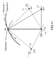
- the figure 11 illustrates schematically an example of geometric configuration associated with the determination of the position of the satellite by trilaterization calculations, in the case of a central station and three remote measurement stations of the central station.
- the SA satellite is on an ellipsoid of revolution around the axis connecting the two foci: central station SC distance measurement 10 and a remote station SDK distance measurement 13. With three distance measurements by three remote stations SD1, SD2 and SD3 separated, we calculate in a conventional manner the position of the SA satellite which is at the intersection of the three ellipsoids. The position of the SA satellite is all the more precise as the ellipsoids are distinct, that is to say when the remote measurement stations 13 are the furthest apart from each other.
- the figure 12 illustrates schematically an example of a geometric configuration in which the central station SC 10 is also a measuring station 13.
- the SA satellite is on a sphere whose radius is the distance SC-SA and whose center is the central station SC. With two distance measurements by two remote stations SD1, SD2, one computes the position of the SA satellite at the intersection of the sphere and the two ellipsoids.
- the computing center 14 may be located in the central station 10 but not necessarily; in this case, it is connected to it by conventional means such as a terrestrial telecommunications network (Internet, telephone line, dedicated line, ).
- a terrestrial telecommunications network Internet, telephone line, dedicated line, .
- the arrival time measurements trk (n) can be sent by the remote measurement stations 13 to the central station 10 and / or directly to the computing center 14, in different ways. This can be via the Internet network 16 as in the first embodiment illustrated in FIG. figure 2 or by satellite radio communication signal 17 as in the second embodiment illustrated in the figure 7 . In the latter case, the measurements can be sent by a frequency-spread radio signal 17 (in dotted line on the figure 7 ). The radio signal 17 then has the same bandwidth and power spectral density level constraints as the distance measurement signal 11.
- This low rate signal Dk (t) is sufficient to return the measurements of the arrival times trk (n) and possibly system information such as the operating and calibration status of the remote station SDk, and / or the time measurements TK necessary for the synchronization of the local clock Tk with the local clock To of the central station in the case of the second illustrated embodiment figure 7 .
Abstract
Description
Le domaine de l'invention est celui de la localisation de satellites géostationnaires.The field of the invention is that of the location of geostationary satellites.
Il est connu de déterminer la position d'un satellite géostationnaire en utilisant un système comportant une station dédiée de mesure de distance entre cette station et le satellite, telle qu'une grande station TCR (acronyme de l'expression anglo-saxonne Telemetry Command and Ranging) émettrice et réceptrice, et un transpondeur spécifique à bord du satellite, inclus dans le sous-système TCR. La mesure de distance, obtenue par la mesure du déphasage induit par la durée de propagation et la traversée du transpondeur TCR du satellite sur une porteuse radiofréquence sinusoïdale ou ton (« tone ranging » en anglais) et associée à une levée d'ambiguïté, est faite de façon périodique (semaine, quinzaine ou mois) selon des procédures bien établies. Entre les campagnes de mesures, la position du satellite est déduite d'un logiciel d'orbitographie. Un tel système est onéreux.It is known to determine the position of a geostationary satellite by using a system comprising a dedicated station for measuring the distance between this station and the satellite, such as a large station TCR (acronym for the English expression Telemetry Command and Ranging) and a specific transponder on board the satellite, included in the TCR subsystem. The measurement of distance, obtained by measuring the phase shift induced by the propagation time and the crossing of the transponder TCR of the satellite on a radio frequency carrier sinusoidal or tone ("tone ranging" in English) and associated with an ambiguity removal, is done periodically (week, fortnight or month) according to well established procedures. Between measurement campaigns, the position of the satellite is deduced from orbitography software. Such a system is expensive.
Une autre solution présentée dans le brevet
Ce système ne fonctionne que si l'opérateur du satellite a accès au signal de télécommunications 21 dans la station de radiodiffusion 20, soit pour connaître l'instant d'émission vers le satellite de mots uniques préexistant dans le signal, soit pour insérer dans le signal des mots uniques à des instants choisis. Cette solution qui est inscrite dans le système de télécommunications par satellite, est donc contrôlée par un opérateur de télécommunications et/ou par un diffuseur et/ou par un opérateur de bouquet (satellite packager) pour ce qui relève du signal de télécommunications 21 et de la station de radiodiffusion 20, et de l'opérateur satellite pour ce qui relève du satellite SA et du transpondeur 22. Cette solution ne peut être utilisée en dehors de l'opérateur de télécommunications et/ou du diffuseur et/ou de l'opérateur de bouquet.This system operates only if the satellite operator has access to the
En conséquence, il demeure à ce jour un besoin pour un système donnant simultanément satisfaction à l'ensemble des exigences précitées, notamment en termes de coût et d'indépendance par rapport à un opérateur de télécommunications.As a result, there remains to date a need for a system that simultaneously satisfies all of the aforementioned requirements, particularly in terms of cost and independence with respect to a telecommunications operator.
Le système de mesure de distance d'un satellite selon l'invention, est une alternative au système distribué présenté en préambule.The distance measurement system of a satellite according to the invention is an alternative to the distributed system presented in the preamble.
Il comprend une station centrale émettrice d'un signal de mesure de distance, et au moins une station de mesure, réceptrice du signal émis. Les positions de la station centrale et des stations de mesure sont connues. Le transpondeur du satellite est celui d'un système de télécommunications par satellite, utilisé pour transmettre des signaux commerciaux (TV par exemple). Le signal de mesure de distance émis par la station centrale est distinct d'un signal de télécommunication. Ce signal de mesure de distance est étalé en fréquence dans la bande du transpondeur satellite, et sa densité spectrale de puissance est de préférence ajustée pour ne pas perturber les signaux commerciaux. Le signal de mesure de distance est avantageusement synthétisé en utilisant une base de temps et de fréquence commune qui est synchronisée sur la base de temps d'un système de navigation par satellite comme GPS ou Galiléo.It comprises a central station transmitting a distance measurement signal, and at least one measurement station, receiving the transmitted signal. The positions of the central station and measuring stations are known. The satellite transponder is that of a satellite telecommunications system, used to transmit commercial signals (TV for example). The distance measurement signal transmitted by the central station is distinct from a telecommunication signal. This distance measurement signal is frequency-spread in the band of the satellite transponder, and its power spectral density is preferably adjusted so as not to disturb the commercial signals. The distance measurement signal is advantageously synthesized using a time and frequency base common which is synchronized on the time base of a satellite navigation system like GPS or Galileo.
La mesure de distance est ainsi basée sur :
- l'émission par la station centrale d'un signal de mesure de distance qui se superpose aux signaux de télécommunications commerciaux au niveau d'un transpondeur banalisé de la charge utile du satellite et,
- sur l'utilisation d'une base de temps commune synchronisée de préférence sur une base de temps externe comme celle d'un système de navigation par satellite (GPS) pour synchroniser les horloges locales de la station centrale et des stations de mesure et éventuellement pour synthétiser le signal de mesure de distance.
- transmitting by the central station a distance measurement signal which is superimposed on the commercial telecommunications signals at an unrestricted transponder of the satellite payload and,
- on the use of a synchronized time base preferably on an external time base such as a satellite navigation system (GPS) for synchronizing the local clocks of the central station and measuring stations and possibly for to synthesize the distance measurement signal.
Plus précisément l'invention a pour objet un système de mesure de distance pour la localisation d'un satellite géostationnaire équipé d'un transpondeur, qui comprend :
- une station centrale émettrice d'un signal de mesure de distance,
- une (ou plusieurs) station(s) de mesure, réceptrice(s) dudit signal de mesure de distance, comportant des moyens de mesure du temps d'arrivée du signal émis par la station centrale et transmis via le transpondeur du satellite,
- la station centrale et les stations de mesure de position connues, comportant des moyens de synchronisation avec une base de temps commune,
- un centre de calcul de la position du satellite,
- des moyens de rapatriement des mesures des stations de mesure vers le centre de calcul.
- a central station transmitting a distance measurement signal,
- one (or more) measuring station (s), receiving (s) said distance measuring signal, comprising means for measuring the arrival time of the signal transmitted by the central station and transmitted via the transponder of the satellite,
- the central station and the known position measuring stations, comprising synchronization means with a common time base,
- a center for calculating the position of the satellite,
- means of repatriation of measurements from measurement stations to the computer center.
Il est principalement caractérisé en ce que:
- le transpondeur est celui d'un système de télécommunications par satellite, et a une bande passante B,
- la station centrale comprend des moyens d'émission d'un signal spécifique de mesure de distance, distinct d'un signal de télécommunication, à évènements périodiques et à étalement de spectre, dont la bande passante est incluse dans B.
- the transponder is that of a satellite telecommunications system, and has a bandwidth B,
- the central station comprises means for transmitting a specific distance measurement signal, distinct from a telecommunication signal, with periodic events and spread spectrum, the bandwidth of which is included in B.
De cette façon, il n'y a pas de ressource satellite (bande de fréquence, puissance radio et matériels) dédiée à la fonction de mesure de distance.In this way, there is no satellite resource (frequency band, radio power and hardware) dedicated to the distance measurement function.
De plus, on peut ainsi faire les mesures de distance et donc la localisation du satellite automatiquement (sans intervention de personnel) et de façon répétitive, toutes les secondes par exemple, pour augmenter la précision de localisation du satellite et de la restitution de l'orbite et pour accéder aux variations de position telles que les dérives et les vitesses de dérives.In addition, it is possible to measure the distance and thus the location of the satellite automatically (without personnel intervention) and repetitively, every second for example, to increase the accuracy of the location of the satellite and the restitution of the satellite. orbit and to access positional variations such as drifts and drift speeds.
En outre, les stations réceptrices sont bon marché car elles sont basées sur des composants électroniques grand public : antenne parabolique, LNB, ordinateur personnel, ...In addition, the receiving stations are cheap because they are based on consumer electronic components: satellite dish, LNB, personal computer, ...
Selon une caractéristique de l'invention, la densité spectrale de puissance est ajustée de façon que ce signal n'affecte pas la qualité de réception du signal de télécommunication.According to a characteristic of the invention, the power spectral density is adjusted so that this signal does not affect the quality of reception of the telecommunication signal.
Le signal de mesure de distance peut transporter un flux de données binaires, typiquement à bas débit c'est-à-dire inférieur à 1 kbit/s.The distance measurement signal can carry a stream of binary data, typically at a low bit rate, that is, less than 1 kbit / s.
Selon un premier mode d'exploitation, la base de temps commune est celle d'un système de positionnement par satellites et les moyens de synchronisation de la station centrale et des stations de mesure comportent des moyens de réception de signaux de positionnement par satellites.According to a first mode of operation, the common time base is that of a satellite positioning system and the synchronization means of the central station and measurement stations comprise means for receiving satellite positioning signals.
L'utilisation d'une base de temps commune synchronisée sur la base de temps d'un système de navigation par satellite comme le système GPS permet d'éviter d'équiper la station émettrice avec une horloge ultra précise telle qu'une horloge atomique qui est coûteuse, ce qui est néanmoins possible. Cela simplifie également les mesures des temps d'arrivée dans les stations réceptrices dont l'horloge locale est également synchronisée sur la base de temps dudit système de navigation par satellite.The use of a synchronized time base on the time base of a satellite navigation system such as the GPS system makes it possible to avoid equipping the transmitting station with an ultra-precise clock such as an atomic clock which is expensive, which is nevertheless possible. This also simplifies the measurements of the arrival times in the receiving stations whose local clock is also synchronized with the time base of said satellite navigation system.
Selon un autre mode d'exploitation, la station centrale comporte une horloge locale qui est la base de temps commune, et les moyens de synchronisation de la station centrale et des stations de mesure comportent des moyens d'émission et de réception d'un signal de transfert bidirectionnel par satellite d'informations horaires et de fréquence.According to another mode of operation, the central station comprises a local clock which is the common time base, and the synchronization means of the central station and measurement stations comprise means for transmitting and receiving a signal. bidirectional satellite transfer of time and frequency information.
Selon une caractéristique de l'invention, les moyens de rapatriement des mesures vers le centre de calcul utilisent les moyens de transmission d'un réseau terrestre de télécommunication, tel que le réseau Internet ou un réseau de téléphonie mobile.According to one characteristic of the invention, the means of repatriation of the measurements towards the computer center use the means of transmission of a terrestrial telecommunication network, such as the Internet or a mobile telephone network.
Selon une variante, les moyens de rapatriement des mesures utilisent le transpondeur du système de télécommunications par satellite et les stations de mesure ont des moyens de transmission d'un signal à étalement de spectre, dont la bande passante est incluse dans B et qui comporte un flux de données binaires incluant lesdites mesures, et la station centrale a des moyens de réception dudit signal pour récupérer les mesures et des moyens pour envoyer les mesures récupérées au centre de calcul.According to one variant, the measurement repatriation means use the transponder of the satellite telecommunications system and the measurement stations have means for transmitting a spread spectrum signal, the bandwidth of which is included in B and which comprises a binary data streams including said measurements, and the central station has means for receiving said signal to retrieve the measurements and means for sending the retrieved measurements to the computing center.
Selon une caractéristique de l'invention, le signal de mesure émis par la station centrale vers la station de mesure déportée et le signal émis par la station de mesure déportée vers la station centrale peuvent comporter en outre les informations horaires et de fréquence.According to one characteristic of the invention, the measurement signal transmitted by the central station to the remote measurement station and the signal transmitted by the remote measurement station to the central station may further comprise the time and frequency information.
La station centrale peut être aussi une station de mesure réceptrice.The central station can also be a receiving measuring station.
Le système de télécommunications par satellite opère typiquement dans les bandes de fréquence allouées au Service de Radiodiffusion par Satellite ou au Service Fixe par Satellite ou au Service Mobile par Satellite.The satellite telecommunications system typically operates in the frequency bands allocated to the Satellite Broadcasting Service or the Fixed Satellite Service or the Mobile Satellite Service.
Selon un mode de réalisation particulier, le centre de calcul comprend des moyens pour déterminer la position du satellite géostationnaire sur la base des mesures des temps d'arrivée faites par :
- au moins trois stations de mesure déportées de la station centrale ou
- au moins deux stations de mesure déportées de la station centrale et la station centrale, celle-ci étant aussi station de mesure.
- at least three remote measurement stations from the central station or
- at least two remote measuring stations of the central station and the central station, which is also a measuring station.
D'autres caractéristiques et avantages de l'invention apparaîtront à la lecture de la description détaillée qui suit, faite à titre d'exemple non limitatif et en référence aux dessins annexés dans lesquels :
- la
figure 1 représente schématiquement un système de télécommunications par satellite utilisé pour effectuer des mesures de distance du satellite, selon l'art antérieur, - la
figure 2 représente schématiquement un système distribué de mesure de distance du satellite, selon un premier mode de réalisation de l'invention, - la
figure 3 illustre schématiquement des exemples de densité spectrale de puissance des signaux qui se superposent dans le transpondeur et un exemple d'abaque permettant d'estimer la dégradation apportée par le signal de mesure de distance à un signal vidéo numérique, - la
figure 4 représente schématiquement le principe de la mesure du temps d'arrivée des évènements périodiques contenus dans le signal de mesure de distance effectuée par une station de mesure déportée, - la
figure 5 représente schématiquement les moyens mis en oeuvre dans la station centrale émettrice dans un premier mode de réalisation de l'invention, - la
figure 6 représente schématiquement les moyens mis en oeuvre dans une station de mesure déportée dans un premier mode de réalisation de l'invention, - la
figure 7 représente schématiquement un système distribué de mesure de distance du satellite, selon un deuxième mode de réalisation de l'invention, - la
figure 8 représente schématiquement le principe de la synchronisation des horloges locales des stations de mesure déportées sur la base de temps commune dans un deuxième mode de réalisation de l'invention, - la
figure 9 représente schématiquement les moyens mis en oeuvre dans la station centrale dans un deuxième mode de réalisation de l'invention, - la
figure 10 représente schématiquement les moyens mis en oeuvres dans une station de mesure dans un deuxième mode de réalisation de l'invention, - la
figure 11 illustre schématiquement un exemple de configuration géométrique associée à la détermination de la position du satellite par calculs de trilatérisation, dans le cas d'une station centrale et de trois stations de mesure déportées, - la
figure 12 illustre schématiquement un exemple de configuration géométrique associée à la détermination de la position du satellite par calculs de trilatérisation, dans le cas d'une station centrale émettrice et réceptrice et de deux stations de mesure déportées.
- the
figure 1 schematically represents a satellite communication system used to perform satellite distance measurements, according to the prior art, - the
figure 2 schematically represents a distributed system for measuring the distance of the satellite, according to a first embodiment of the invention, - the
figure 3 schematically illustrates examples of power spectral density of the signals that are superimposed in the transponder and an example of an abacus for estimating the degradation provided by the distance measurement signal to a digital video signal, - the
figure 4 schematically represents the principle of measuring the arrival time of the periodic events contained in the distance measurement signal taken by a remote measurement station, - the
figure 5 schematically represents the means implemented in the central transmitting station in a first embodiment of the invention, - the
figure 6 schematically represents the means implemented in a remote measurement station in a first embodiment of the invention, - the
figure 7 schematically represents a distributed system for measuring the distance of the satellite, according to a second embodiment of the invention, - the
figure 8 schematically represents the principle of the synchronization of the local clocks of the remote measurement stations on the basis of common time in a second embodiment of the invention, - the
figure 9 schematically represents the means implemented in the central station in a second embodiment of the invention, - the
figure 10 schematically represents the means implemented in a measuring station in a second embodiment of the invention, - the
figure 11 schematically illustrates an example of a geometric configuration associated with the determination of the position of the satellite by trilaterization calculations, in the case of a central station and three remote measurement stations, - the
figure 12 schematically illustrates an example of a geometric configuration associated with the determination of the position of the satellite by trilaterization calculations, in the case of a central transmitting and receiving station and two remote measurement stations.
D'une figure à l'autre, les mêmes éléments sont repérés par les mêmes références.From one figure to another, the same elements are identified by the same references.
On décrit en relation avec la
Il comprend une station centrale émettrice 10 qui émet vers des stations de mesure déportées réceptrices 13 (une seule station de mesure est représentée sur la figure pour ne pas la surcharger) un signal 11 de mesure de distance à évènements périodiques et à étalement de spectre via le transpondeur 22 d'un satellite SA d'un système de télécommunications 200, dit transpondeur de télécommunication. Le système 100 selon l'invention utilise le transpondeur d'un autre système, en l'occurrence celui d'un système 200 de télécommunications par satellite. La station centrale émettrice 10 est distincte de celle 20 du système de télécommunications en ce sens que le signal 11 émis par la station 10 est distinct du signal de télécommunications 21 émis par la station 20. Les deux stations émettrices 10 et 20 peuvent éventuellement être localisées au même endroit.It comprises a central transmitting
Le signal de mesure de distance 11 est typiquement un code d'étalement récurrent tel qu'une séquence directe de longueur finie, modulant une porteuse radiofréquence. Eventuellement, le signal de mesure de distance 11 contient également un flux de donnée binaire à bas débit D(t) c'est-à-dire inférieur à 1 kbit/s, typiquement pour transporter des informations horaires et de fréquences comme on va le voir plus loin, ou pour transmettre des données auxiliaires comme des données relatives à l'état du système, des données de calibrations, des télécommandes de configuration de la station de mesure.... Ce signal de mesure de distance est spécifique de cette application ; il est distinct du signal de télécommunications 21 mais doit pouvoir être transmis par le transpondeur 22 de télécommunication. Son spectre occupe tout ou partie de la bande passante B du transpondeur de télécommunication. On a typiquement B compris entre 22 MHz et 72 MHz dans le cas d'un transpondeur d'un système de télécommunications par satellite opérant dans la bande Ku (10,7 GHz à 14,5 GHz).The
Le dispositif de l'invention fonctionne aussi dans tout transpondeur d'un système de télécommunications par satellite fonctionnant dans les bandes de fréquence qui sont allouées par l'Union Internationale des Télécommunications (UIT) au Service Fixe par Satellite (SFS), au Service de Radiodiffusion par Satellite (SRS) et au Service Mobile par Satellite (SMS), et dont la bande passante B est suffisante pour étaler le signal de mesure de distance. Il est de préférence étalé de manière à ce que sa densité spectrale de puissance soit inférieure à la densité spectrale de puissance du bruit dudit transpondeur.The device of the invention also functions in any transponder of a satellite telecommunications system operating in the frequency bands which are allocated by the International Telecommunication Union (ITU) to the Fixed Satellite Service (SFS), to the Service de Satellite Broadcasting (SRS) and the Mobile Satellite Service (SMS), whose bandwidth B is sufficient to spread the distance measurement signal. It is preferably spread so that its power spectral density is lower than the power spectral density of the noise of said transponder.
Différentes techniques d'étalement de spectre peuvent être utilisées. On peut citer l'étalement par séquence directe aussi désignée « pseudo noise (PN) spread » en langue anglaise, par saut de fréquence ou « frequency hopping » en langue anglaise ou par ultra large bande ou « ultra wide band » en langue anglaise. Dans un mode de réalisation préféré de l'invention, le signal de mesure de distance est un signal binaire bas débit étalé en fréquence par séquence directe récurrente de longueur finie ou également appelé code (« pseudorandom noise code » en anglais). La structure de ce signal R(t) peut être modélisée en fonction du temps t par : ![]()
où A(t) est l'amplitude du signal, C(t) est la séquence directe récurrente de longueur finie ou code, D(t) est le flux de donnée système à bas débit, fo est la fréquence de la porteuse, Φo est la phase initiale de la porteuse.Different spread spectrum techniques can be used. We can quote the direct sequence spreading also called "pseudo noise (PN) spread" in English language, by frequency hopping or "frequency hopping" in English language or by ultra broad band or "ultra wide band" in English language. In a preferred embodiment of the invention, the distance measurement signal is a low bit rate binary signal spread by frequency by direct sequence recurring finite length or also called code ("pseudorandom noise code" in English). The structure of this signal R (t) can be modeled as a function of time t by: ![]()
where A (t) is the amplitude of the signal, C (t) is the recursive direct sequence of finite length or code, D (t) is the low-speed system data stream, fo is the carrier frequency, Φo is the initial phase of the carrier.
De plus comme montré ![]()
![]()
A titre d'illustration, la
Ce signal 11 de mesure de distance peut éventuellement comporter un signal binaire D(t) bas débit véhiculant des informations auxiliaires destinées aux stations de mesure comme par exemple : le nom du satellite, la date, l'heure, la fréquence porteuse, des données de calibration, des données de maintenance, etc.This
La forme d'onde (qui définit le signal) permet d'effectuer des mesures de distance précises et est synthétisée avec la base de temps commune 18 qui est dans un mode de réalisation préféré de l'invention synchronisée sur une référence de temps extérieure de type GPS par exemple.The waveform (which defines the signal) makes it possible to carry out accurate distance measurements and is synthesized with the
De préférence, ce signal de mesure de distance R(t) est similaire à un signal de navigation de type GPS ou Galileo. Ainsi par exemple le signal de mesure de distance a les caractéristiques suivantes :
- C(t) signal d'étalement (séquence directe) au débit de 18 Mchip/s,
- D(t) signal binaire (flux d'information) au débit de 1000 bits par seconde,
- période de la séquence directe (évènement) : 1 milliseconde,
- modulation BPSK ou toute autre modulation de même type.
- C (t) spreading signal (direct sequence) at the rate of 18 Mchip / s,
- D (t) binary signal (information flow) at a rate of 1000 bits per second,
- period of the direct sequence (event): 1 millisecond,
- BPSK modulation or any other modulation of the same type.
Le débit binaire du flux d'information D(t) est fixé en fonction des conditions de transmission sur la liaison station centrale émettrice 10 vers la station de mesure déportée 13 via le transpondeur 22 du satellite SA. En particulier le débit maximum est déterminé par la combinaison des valeurs de plusieurs paramètres des systèmes de télécommunications 200 et de mesure de distance 100, comme par exemple le rapport signal à bruit (S/N)t du signal de télécommunications 11, la dégradation « d », le rapport z, le facteur de mérite de la station de mesure, réceptrice (G/T)...The bit rate of the information flow D (t) is set as a function of the transmission conditions on the transmitting
Le système 100 de mesure de distance comprend aussi au moins une station de mesure 13 généralement déportée de la station centrale 10. Chaque station de mesure 13 reçoit le signal de mesure de distance 11 qui est par exemple une séquence directe récurrente de longueur finie C(t). Elle comprend des moyens pour détecter et extraire le signal de mesure de distance superposé au signal de télécommunications 21 de manière classique connue de l'homme du métier, par corrélation avec une réplique locale de la séquence directe. De cette manière, le signal binaire bas débit D(t) est extrait du signal de télécommunications 21 et peut être ensuite démodulé par un matériel approprié comme illustré
La séquence directe récurrente de longueur finie C(t) est utilisée pour faire la mesure du temps d'arrivée des événements périodiques qui sont dans ce mode de réalisation les débuts de la séquence directe. Le temps d'arrivée du début de la séquence directe est mesuré sur la base de l'horloge locale Tk de la station de mesure réceptrice 13 par un moyen approprié et connu de l'homme du métier.The recursive direct sequence of finite length C (t) is used to measure the arrival time of the periodic events which in this embodiment are the beginnings of the direct sequence. The arrival time of the beginning of the direct sequence is measured on the basis of the local clock Tk of the receiving
La pseudo-distance (PD) entre la station émettrice et la station de mesure réceptrice via le satellite est donnée par la formule ![]()
où c est la vitesse de la lumière, te(n) est le temps de l'émission du n-ième début du code mesuré avec l'horloge locale To de la station centrale émettrice et tr(n) est la mesure du temps d'arrivée du n-iéme début du code mesuré avec l'horloge locale Tk de la station déportée de réception k. Cette pseudo-distance est différente de la distance réelle car elle contient des erreurs. La principale erreur est due au biais entre l'horloge locale de la station émettrice et l'horloge locale de la station réceptrice [To - Tk]. La synchronisation de toutes les horloges locales sur une base de temps commune 18 permet de supprimer le biais ou d'en connaître la valeur et ainsi de supprimer ou réduire l'erreur sur la distance. Les autres erreurs sont connues ou mesurables et sont compensées par des moyens connus de l'homme du métier (effet Sagnac, non réciprocité en fréquence des temps de propagation, traversée de l'ionosphère...) .The pseudo-distance (PD) between the transmitting station and the receiving measuring station via the satellite is given by the formula ![]()
where c is the speed of light, te (n) is the time of emission of the nth beginning of the code measured with the local clock To of the transmitting central station and tr (n) is the measurement of the time of arrival of the n-th beginning of the measured code with the local clock Tk of the remote receiving station k. This pseudo-distance is different from the actual distance because it contains errors. The main error is due to the bias between the local clock of the transmitting station and the local clock of the receiving station [To - Tk]. The synchronization of all the local clocks on a
Les horloges locales Tk des stations déportées 13 sont synchronisées avec l'horloge locale To de la station centrale 10 pour avoir une base de temps commune 18.The local clocks Tk of the
Cette synchronisation peut être obtenue en prenant une base de temps commune extérieure au système, comme par exemple le temps fourni par un système de positionnement par satellite tel que le système GPS ou Galileo. Les stations 10 et 13 sont alors équipées de moyens 15 de réception d'un signal de positionnement par satellite de type GNSS comme on peut respectivement le voir
Une base de temps commune peut aussi être obtenue en équipant la station centrale 10 avec une horloge atomique. Cette horloge est la référence de la base de temps commune. Ce mode de réalisation de l'invention est illustré à la
Les signaux radiofréquences utilisés pour le transfert bidirectionnel par satellite de signaux horaires transiteront par le transpondeur 22 du satellite SA du système de télécommunications 200.The radio frequency signals used for the bidirectional satellite transfer of time signals will pass through the
Les stations 10 et 13 comprennent des moyens d'émission et de réception d'un signal spécifique de transfert bidirectionnel par satellite de signaux horaires, que l'on peut voir
Le signal de transfert bidirectionnel par satellite d'informations horaires peut être confondu ou fusionné comme montré sur les
- dans le sens station centrale 10 vers station de mesure 13, avec le signal de mesure de distance émis 11 et
- dans le sens station de mesure 13 vers station centrale 10, avec le signal 17 comportant les mesures.
- in the
central station direction 10 tomeasurement station 13, with the distance measurement signal transmitted 11 and - in the
direction measuring station 13 tocentral station 10, with thesignal 17 comprising the measurements.
La station centrale 10 et les stations de mesure 13 sont dans la couverture 24 du satellite SA de télécommunication.The
Le système de mesure de distance 100 comprend également un centre de calcul 14 qui détermine la position du satellite SA, à partir des mesures des temps d'émission des événements te(n) par la station centrale 10 et des mesures du temps d'arrivée des événements trk(n) par les stations de mesure 13 ; chacune des stations de mesure envoie périodiquement les mesures de temps d'arrivée de l'événement périodique du signal de mesure de distance (le début de la séquence directe dans un des modes de réalisation de l'invention).The
Le centre de calcul 14 calcule la distance entre la station centrale 10 et la k-ième station de mesure 13 via le satellite SA [SC-SA + SA-SDk]. Enfin le centre de calcul 14 calcule la position du satellite par des méthodes de trilatérisation bien connues.The
La
La
Le centre de calcul 14 peut être situé dans la station centrale 10 mais pas nécessairement ; dans ce cas, il lui est relié par des moyens classiques tels qu'un réseau terrestre de télécommunications (Internet, ligne téléphonique, ligne spécialisée, ... ).The
Les mesures de temps d'arrivée trk(n) peuvent être envoyées par les stations de mesure déportées 13 à la station centrale 10 et/ou directement au centre de calcul 14, de différentes manières. Cela peut être par le réseau Internet 16 comme dans le premier mode de réalisation illustré à la
Claims (7)
Applications Claiming Priority (1)
| Application Number | Priority Date | Filing Date | Title |
|---|---|---|---|
| FR1001867A FR2959571B1 (en) | 2010-04-30 | 2010-04-30 | DISTRIBUTED DISTANCE MEASUREMENT SYSTEM FOR LOCATING A GEOSTATIONARY SATELLITE. |
Publications (1)
| Publication Number | Publication Date |
|---|---|
| EP2386875A1 true EP2386875A1 (en) | 2011-11-16 |
Family
ID=43063855
Family Applications (1)
| Application Number | Title | Priority Date | Filing Date |
|---|---|---|---|
| EP11163926A Withdrawn EP2386875A1 (en) | 2010-04-30 | 2011-04-27 | Verteiltes Entfernungsmesssystem für die Lokalisierung eines geostationären Satelliten |
Country Status (6)
| Country | Link |
|---|---|
| US (1) | US8451166B2 (en) |
| EP (1) | EP2386875A1 (en) |
| AR (1) | AR081140A1 (en) |
| AU (1) | AU2011202005A1 (en) |
| CA (1) | CA2738268A1 (en) |
| FR (1) | FR2959571B1 (en) |
Cited By (2)
| Publication number | Priority date | Publication date | Assignee | Title |
|---|---|---|---|---|
| CN105657813A (en) * | 2016-01-04 | 2016-06-08 | 北京航空航天大学 | Time synchronization and distance measurement combined method among anchor-free nodes |
| US20230232350A1 (en) * | 2022-01-19 | 2023-07-20 | Intelligent Fusion Technology, Inc. | Methods and systems for time synchronization among unmanned aerial systems |
Families Citing this family (16)
| Publication number | Priority date | Publication date | Assignee | Title |
|---|---|---|---|---|
| FR2969449B1 (en) | 2010-12-17 | 2013-03-22 | Thales Sa | METHOD AND SYSTEM FOR TRANSMISSION USING ADAPTIVE AND PROGRAMMABLE HIERARCHICAL MODULATION |
| CN102545993B (en) * | 2011-12-20 | 2014-04-02 | 中国科学院国家授时中心 | Two-way satellite time transfer method based on carrier phase |
| US8929278B2 (en) * | 2012-02-06 | 2015-01-06 | Maxlinear, Inc. | Method and apparatus for content protection and billing for mobile delivery of satellite content |
| US9019155B2 (en) | 2012-05-03 | 2015-04-28 | Raytheon Company | Global positioning system (GPS) and doppler augmentation (GDAUG) and space location inertial navigation geopositioning system (SPACELINGS) |
| US9365303B2 (en) * | 2012-05-03 | 2016-06-14 | Raytheon Company | Position and elevation acquisition for orbit determination |
| US8897206B2 (en) | 2012-05-23 | 2014-11-25 | Hughes Network Systems, Llc | Frame timing synchronization in a geostationary satellite system |
| US9075126B2 (en) | 2012-06-28 | 2015-07-07 | Raytheon Company | Ground location inertial navigation geopositioning system (groundlings) |
| US10231201B2 (en) * | 2014-12-08 | 2019-03-12 | Nextnav, Llc | Systems and methods for assured time synchronization of an RF beacon |
| CN105071851B (en) * | 2014-12-30 | 2018-06-29 | 北京无线电计量测试研究所 | A kind of calibrating installation and method of two-way satellite time and frequency transfer system |
| US10775749B2 (en) | 2015-04-17 | 2020-09-15 | The Mitre Corporation | Robust and resilient timing architecture for critical infrastructure |
| US9985713B2 (en) * | 2015-07-09 | 2018-05-29 | Hughes Network Systems, Llc | Apparatus and method for generating boundaries of satellite coverage beams |
| ITUB20154134A1 (en) * | 2015-10-01 | 2017-04-01 | Univ Degli Studi Dellaquila | SYNCHRONIZATION SYSTEM AND METHOD |
| CN107483137B (en) * | 2017-09-04 | 2019-06-28 | 西南电子技术研究所(中国电子科技集团公司第十研究所) | Multistation split-second precision frequency synchronization method |
| CN107566070B (en) * | 2017-09-04 | 2019-05-07 | 西南电子技术研究所(中国电子科技集团公司第十研究所) | The method of one-way synchronization transmission time frequency |
| CN110395413B (en) * | 2019-07-03 | 2021-04-13 | 中国卫通集团股份有限公司 | Automatic scheduling method for rapid orbit determination multi-testing station |
| CA3169752A1 (en) | 2020-02-28 | 2021-09-02 | Aaron J. WILZ | Pedestal for a retrofit remote control device and retrofit remote control device |
Citations (3)
| Publication number | Priority date | Publication date | Assignee | Title |
|---|---|---|---|---|
| FR2621132A1 (en) * | 1987-09-30 | 1989-03-31 | Europ Agence Spatiale | Method and device for measuring distances |
| US5041833A (en) * | 1988-03-28 | 1991-08-20 | Stanford Telecommunications, Inc. | Precise satellite ranging and timing system using pseudo-noise bandwidth synthesis |
| US6864838B2 (en) | 1999-02-08 | 2005-03-08 | Societe Europeenne Des Satellites S.A. | Ranging system and method for satellites |
Family Cites Families (4)
| Publication number | Priority date | Publication date | Assignee | Title |
|---|---|---|---|---|
| JP3405624B2 (en) * | 1995-09-29 | 2003-05-12 | 株式会社東芝 | GPS overlay system for geostationary satellite |
| FR2778805B1 (en) | 1998-05-14 | 2000-06-16 | Alsthom Cge Alcatel | SATELLITE COMMUNICATION SYSTEM FOR BROADCASTING AUDIOVISUAL PROGRAMS AND MULTIMEDIA DATA |
| US8185785B2 (en) * | 2006-11-28 | 2012-05-22 | At&T Intellectual Property I, L.P. | Broadcasting of digital video to mobile terminals |
| FR2928510B1 (en) | 2008-03-04 | 2011-07-29 | Thales Sa | SYSTEM FOR FORMING BEAMS WITH DIGITAL TRANSMISSION GROUND-BASED PROCESSING |
-
2010
- 2010-04-30 FR FR1001867A patent/FR2959571B1/en not_active Expired - Fee Related
-
2011
- 2011-04-27 EP EP11163926A patent/EP2386875A1/en not_active Withdrawn
- 2011-04-28 CA CA2738268A patent/CA2738268A1/en not_active Abandoned
- 2011-04-29 US US13/098,202 patent/US8451166B2/en active Active
- 2011-04-29 AR ARP110101495A patent/AR081140A1/en unknown
- 2011-05-02 AU AU2011202005A patent/AU2011202005A1/en not_active Abandoned
Patent Citations (3)
| Publication number | Priority date | Publication date | Assignee | Title |
|---|---|---|---|---|
| FR2621132A1 (en) * | 1987-09-30 | 1989-03-31 | Europ Agence Spatiale | Method and device for measuring distances |
| US5041833A (en) * | 1988-03-28 | 1991-08-20 | Stanford Telecommunications, Inc. | Precise satellite ranging and timing system using pseudo-noise bandwidth synthesis |
| US6864838B2 (en) | 1999-02-08 | 2005-03-08 | Societe Europeenne Des Satellites S.A. | Ranging system and method for satellites |
Non-Patent Citations (1)
| Title |
|---|
| "Satellite Earth Stations and Systems (SES); Technical analysis of Spread Spectrum Solutions for Telemetry Command and Ranging (TCR) of Geostationary Communications Satellites; ETSI TR 101 956", ETSI STANDARDS, LIS, SOPHIA ANTIPOLIS CEDEX, FRANCE, vol. SES-ECSS, no. V1.1.1, 1 September 2001 (2001-09-01), XP014005037, ISSN: 0000-0001 * |
Cited By (4)
| Publication number | Priority date | Publication date | Assignee | Title |
|---|---|---|---|---|
| CN105657813A (en) * | 2016-01-04 | 2016-06-08 | 北京航空航天大学 | Time synchronization and distance measurement combined method among anchor-free nodes |
| CN105657813B (en) * | 2016-01-04 | 2019-02-05 | 北京航空航天大学 | Joint time synchronization and distance measuring method between a kind of no anchor node |
| US20230232350A1 (en) * | 2022-01-19 | 2023-07-20 | Intelligent Fusion Technology, Inc. | Methods and systems for time synchronization among unmanned aerial systems |
| US11864140B2 (en) * | 2022-01-19 | 2024-01-02 | Intelligent Fusion Technology, Inc. | Methods and systems for time synchronization among unmanned aerial systems |
Also Published As
| Publication number | Publication date |
|---|---|
| US20110267229A1 (en) | 2011-11-03 |
| FR2959571A1 (en) | 2011-11-04 |
| AU2011202005A1 (en) | 2011-11-17 |
| US8451166B2 (en) | 2013-05-28 |
| FR2959571B1 (en) | 2013-03-22 |
| CA2738268A1 (en) | 2011-10-30 |
| AR081140A1 (en) | 2012-06-27 |
Similar Documents
| Publication | Publication Date | Title |
|---|---|---|
| EP2386875A1 (en) | Verteiltes Entfernungsmesssystem für die Lokalisierung eines geostationären Satelliten | |
| EP2444823B1 (en) | Method and system for geopositioning of a radio beacon in a warning system | |
| EP1804399B1 (en) | Method for synchronising base stations of a terrestrial-cellular communication network | |
| EP0902899B1 (en) | Satellite signal receiver with position extrapolation filter | |
| EP3698173B1 (en) | Positioning system with gnss signal generation means and radiating cable | |
| EP2587691B1 (en) | Method for the coordinated processing of signals transmitted by beacons | |
| EP1544636B1 (en) | Determination device by filtering of integrity data in a differential positioning system, for a mobile terminal | |
| FR2801682A1 (en) | Satellite telecommunications parasitic transmission position location technique having interferometric frequency difference measurement providing detection satellite/line parasitic transmitter/satellite angle | |
| FR2878684A1 (en) | Mobile terminal locating device for e.g. global system for mobile communication network, has processing unit to determine position of terminal by triangulation based on signals from base stations and data of time offsets of stations | |
| EP3345013B1 (en) | Payload of a positioning system measurement satellite, and positioning method | |
| EP2959308B1 (en) | Method and system for estimating the direction of arrival of a target signal relative to a satellite | |
| EP1907875A1 (en) | Positioning method, device and system using multi-source synchronous pulsed relay | |
| EP0938683B1 (en) | Satellite signal receiver with detector of incoherence between code phase and carrier frequency measurements | |
| EP1697757A1 (en) | Method of updating the clock bias between a bts station of a gsm network and the satellites of a gps system | |
| EP3579025A1 (en) | Method and device for continuity of the geolocation service inside buildings for terminals using gnss signals | |
| EP1907876B1 (en) | Mobile equipment, method and system for positioning a mobile equipment | |
| EP2392940B1 (en) | System for positioning a geostationary satellite | |
| EP0839324B1 (en) | System and method for measuring the total electron content of the ionosphere | |
| FR3106216A1 (en) | Method of providing a time and / or positioning service, regenerator device, corresponding receiver device and time server. | |
| WO1998037431A1 (en) | System for remote sensing of the position of a moving vehicle |
Legal Events
| Date | Code | Title | Description |
|---|---|---|---|
| AK | Designated contracting states |
Kind code of ref document: A1 Designated state(s): AL AT BE BG CH CY CZ DE DK EE ES FI FR GB GR HR HU IE IS IT LI LT LU LV MC MK MT NL NO PL PT RO RS SE SI SK SM TR |
|
| AX | Request for extension of the european patent |
Extension state: BA ME |
|
| PUAI | Public reference made under article 153(3) epc to a published international application that has entered the european phase |
Free format text: ORIGINAL CODE: 0009012 |
|
| 17P | Request for examination filed |
Effective date: 20120511 |
|
| 17Q | First examination report despatched |
Effective date: 20120718 |
|
| STAA | Information on the status of an ep patent application or granted ep patent |
Free format text: STATUS: THE APPLICATION IS DEEMED TO BE WITHDRAWN |
|
| 18D | Application deemed to be withdrawn |
Effective date: 20130522 |