EP2366094B1 - Method with pressure altitude correction for an aircraft - Google Patents
Method with pressure altitude correction for an aircraft Download PDFInfo
- Publication number
- EP2366094B1 EP2366094B1 EP09775186.1A EP09775186A EP2366094B1 EP 2366094 B1 EP2366094 B1 EP 2366094B1 EP 09775186 A EP09775186 A EP 09775186A EP 2366094 B1 EP2366094 B1 EP 2366094B1
- Authority
- EP
- European Patent Office
- Prior art keywords
- values
- altitude
- pairs
- correcting
- barometric altitude
- Prior art date
- Legal status (The legal status is an assumption and is not a legal conclusion. Google has not performed a legal analysis and makes no representation as to the accuracy of the status listed.)
- Active
Links
- 238000000034 method Methods 0.000 title claims description 34
- 238000012937 correction Methods 0.000 title claims description 27
- 238000001514 detection method Methods 0.000 claims description 29
- 230000001427 coherent effect Effects 0.000 claims description 3
- 238000009499 grossing Methods 0.000 claims description 2
- 238000010586 diagram Methods 0.000 description 4
- 230000004075 alteration Effects 0.000 description 3
- 230000001419 dependent effect Effects 0.000 description 3
- 238000012795 verification Methods 0.000 description 3
- 238000013459 approach Methods 0.000 description 2
- 238000004891 communication Methods 0.000 description 2
- 230000002349 favourable effect Effects 0.000 description 2
- 230000007257 malfunction Effects 0.000 description 2
- 238000012544 monitoring process Methods 0.000 description 2
- 230000004044 response Effects 0.000 description 2
- 241000861223 Issus Species 0.000 description 1
- 230000005540 biological transmission Effects 0.000 description 1
- 238000002592 echocardiography Methods 0.000 description 1
- 230000000694 effects Effects 0.000 description 1
- 238000011156 evaluation Methods 0.000 description 1
- 230000010006 flight Effects 0.000 description 1
- 230000006870 function Effects 0.000 description 1
- 239000007789 gas Substances 0.000 description 1
- 230000005484 gravity Effects 0.000 description 1
- 230000002706 hydrostatic effect Effects 0.000 description 1
- 230000033001 locomotion Effects 0.000 description 1
- 238000005259 measurement Methods 0.000 description 1
- 230000008520 organization Effects 0.000 description 1
- 230000001902 propagating effect Effects 0.000 description 1
- 230000007704 transition Effects 0.000 description 1
Images


Classifications
-
- G—PHYSICS
- G01—MEASURING; TESTING
- G01C—MEASURING DISTANCES, LEVELS OR BEARINGS; SURVEYING; NAVIGATION; GYROSCOPIC INSTRUMENTS; PHOTOGRAMMETRY OR VIDEOGRAMMETRY
- G01C5/00—Measuring height; Measuring distances transverse to line of sight; Levelling between separated points; Surveyors' levels
- G01C5/005—Measuring height; Measuring distances transverse to line of sight; Levelling between separated points; Surveyors' levels altimeters for aircraft
Definitions
- the present invention relates to a method for correcting the barometric altitude of aircraft used in an air traffic control system. It relates in particular to aircraft tracking systems based on multiple sensors.
- Air Traffic Control allows air traffic controllers to ensure the safe, rapid and efficient execution of aircraft flights in monitored airspace. Its role is primarily to prevent collisions between aircraft and ground or vehicles, as well as collisions in flight between aircraft. It also consists in speeding up and ordering the air traffic, in providing the aircraft with the opinions and information useful for the safe and efficient execution of the flight, such as meteorological information, information on the state of the navigational means, traffic information. Finally, it consists in providing an alert service to warn the appropriate agencies when the aircraft need help from the rescue and rescue organizations, and to lend them the necessary assistance.
- the data necessary for the management of air traffic control comes mainly from a plurality of sensors.
- primary surveillance radars or PSRs acronym for Primary Surveillance Radars, provide target echoes, via azimuth, distance and time of detection information.
- SSRs Secondary Surveillance Radars
- An SSR sends signals to targets.
- targets are aircraft equipped with transponders, they send back information, which is received by the SSR.
- the information received by the SSR includes the distance and the azimuth, as well as the additional information provided by the transponder according to its type.
- a transponder compatible with the A / C mode provides an aircraft identification data (mode A), and a barometric altitude datum. (C mode). All of the data provided by an SSR thus makes it possible to identify the aircraft operating in its field of vision, as well as the knowledge of their respective positions in a three-dimensional reference frame.
- There are still transponders equipped with an advanced mode or Mode S providing on request the same data as the A / C mode, in addition to a unique identification of the aircraft coded on 24 bits, and means of two-way communication various data.
- multilateration sensors consisting of a plurality of omni-directional antennas scattered over the ground, receiving signals from an aircraft to locate it. These signals may be unsolicited, or sent by the aircraft in response to signals from radars. Calculations relating to the differences between the times of reception of these signals between at least two antennas make it possible to determine the position of the aircraft.
- This type of sensor is widely used for monitoring ground movements in airport areas and in approach areas.
- Another technique proceeding in a similar manner is used for the location of aircraft outside airport approach zones, based on signals received by a plurality of omnidirectional antennas disposed over much wider geographical areas; this technique is called WAM, according to the acronym for Wide Area Multilateration.
- ADS-C Automatic Dependent Surveillance - Contract
- a first ADS system called ADS-C according to the acronym for Automatic Dependent Surveillance - Contract
- ADS-C Automatic Dependent Surveillance - Contract
- the aircraft that are equipped with it broadcast to a communication satellite data relating to their position, for example determined by an on-board computer based on data provided by a satellite or GPS geo-location receiver according to the acronym for Global Positioning. System, and / or by an inertial unit.
- Other data is disseminated, such as data on the route envisaged by the aircraft, the speeds of the aircraft relative to the air and the ground, data weather (wind force and direction, temperature, etc.).
- the dissemination of these data by the aircraft can be done periodically, or in response to certain events, or in case of emergency.
- the data is then transmitted by the satellite and is received by a dedicated antenna.
- a second system of ADS is called ADS-B according to the acronym for Automatic Depends Surveillance - Broadcast.
- Aircraft equipped with them broadcast the data described above with reference to ADS-C, directly to a ground antenna. The transmission is made periodically, at a much higher frequency, of at least one emission per second.
- the tracking of an aircraft consists in following its track, that is to say, the representation of the evolution of the aircraft in the airspace, in projection on the stereographic level situated at sea level. data of major importance in the location of an aircraft, so its tracking, is the altitude.
- the data provided by an SSR contains an altitude-related component: this is the barometric altitude provided by the transponder mode C.
- the barometric altitude transmitted by mode C and derived from an alticoder is given with reference to the standard pressure at sea level under normal conditions of pressure and temperature, namely: 1013.25 hectoPascal for a temperature atmospheric pressure may vary significantly from one geographical area to another relatively close, the data of the barometric altitude mode C used in the calculations must be accompanied by a strong variance.
- Uncertainty or variance in the estimation of the altitude of an aircraft is reflected in the position calculations, as well as in all calculations implemented in an air traffic control system, such as calculations carried out in order to trigger alerts in case of risk of collisions between aircraft. It is therefore desirable to apply a correction to the barometric altitude of the A / C mode radars, in order to improve the accuracy of the position, and to reduce the variance.
- controllers it is useful for controllers to know geometric altitudes of aircraft, or barometric altitudes corrected for weather conditions in areas where aircraft are located.
- a corrected barometric altitude is provided with reference to the QNH: the QNH takes into account the current sea level pressure value.
- the air traffic control unit shall make a correction of the barometric altitude values according to the QNH only in the area in which it is located, ie typically in the airport area, according to the data provided by meteorological services. These data are updated with a very low frequency (for example: once a day): not only can the pressure in the airport area vary significantly over time, between two updates of the atmospheric pressure data by the meteorological service, but again it can vary significantly between the airport area and an area distant from the airport, in the area of interest. For this reason, the barometric altitude correction is only performed in airport areas, for aircraft operating at low altitudes, that is, at altitudes below the transition altitude. In an airport zone, the barometric altitude is taken into account by the filter in position, and considered as a geometric altitude with associated variance plus a fixed value to compensate for the maximum variation of the barometric correction.
- US 5,402,116 A uses two transceivers, separated by a fixed distance, which collect the data of altitudes and barometric values.
- Rotary antenna transceivers interrogate passing aircraft.
- the altitude datum is biased, more or less strongly, in depending on the weather conditions. Consequently, the evaluation of the accuracy of the tracking is made random according to whether the atmospheric conditions are favorable or unfavorable, that is to say more or less close to the standard atmospheric conditions.
- the component at altitude is over-stretched, which degrades the accuracy of the filter in position, in particular when the target is maneuvering.
- An object of the present invention is to overcome the aforementioned drawbacks, in particular by proposing a method capable of applying to the barometric altitudes of the aircraft present in a surveillance zone, an appropriate correction as a function of the atmospheric conditions surrounding each of the aircraft, in order to reduce the variance on the altitude values and thus the accuracy of the calculations, without specific data being provided by meteorological services.
- the method for correcting the barometric altitude of aircraft described above can be characterized in that the pairs of values (C; H) stored during the acquisition step and memorization are deleted if they correspond to detections at altitude levels lower than a first determined threshold and / or above a second determined threshold.
- the method for correcting the barometric altitude of aircraft described above can be characterized in that the two pairs of values (C i ; H i ) and (C j ; H j ) are respectively the two pairs corresponding to the two detections of lower geometric altitude H.
- the method for correcting the barometric altitude of aircraft described above can be characterized in that the calculation step further comprises a step of verifying the consistency of the values of the pairs (C; H) stored for a given cell, a pair of values (C; H) being considered coherent if the difference between the corrected value of the barometric altitude C and the geometric altitude H is less than a determined threshold or inconsistent otherwise; one or more pairs of values considered as incoherent leading to the choice of two different pairs (C i ; H i ) and (C j ; H j ).
- the method for correcting the barometric altitude of aircraft described above can be characterized in that pressure and temperature values at sea level (P 0 ; T 0 ) are calculated during the calculation step, for all pairs of values (C; H) of a given cell, the calculation step comprising an additional calculation providing an average of the values (P 0 ; T 0 ) calculated and applying to the cell the average value of the torque (P 0 ; T 0 ).
- the method for correcting the barometric altitude of aircraft described above can be characterized in that the calculation step comprises an additional calculation of the pressure and temperature values at the level of the aircraft. of the sea (P 0 ; T 0 ) for cells for which no pair of values (P 0 ; T 0 ) are assigned and juxtaposed to at least a determined number of adjacent cells for which values (P 0 ; T 0 ) have been determined, the calculation assigning the cells the average barycentric values (P 0 ; T 0 ) of all adjacent cells.
- the method for correcting the barometric altitude of aircraft described above can be characterized in that the determined number of adjacent cells for which values (P 0 ; T 0 ) have been determined is equal to 4.
- the method for correcting the barometric altitude of aircraft described above can be characterized in that no value of the torque (P 0 ; T 0 ) is calculated for a given cell during the calculation step if the number of pairs of values (C; H) stored for this cell is less than a predetermined number.
- the method for correcting the barometric altitude of aircraft described above can be characterized in that the predetermined number of stored pairs of values (C; H) is equal to 5.
- the method for correcting the barometric altitude of aircraft described above can be characterized in that the pressure and temperature values at sea level (P 0n ; T 0n ) for a given cell, as calculated during the calculation step for a time window n, are smoothed with the values (P 0n-1 ; T 0n-1 ) determined for the cell for a previous time window n- 1, the smoothing attributing to the pair of values (P 0 ; T 0 ) the value ⁇ . (P 0n-1 ; T 0n-1 ) + (1- ⁇ ). (P 0n ; T 0n ), ⁇ being a coefficient between 0 and 1.
- the invention may finally have the purpose of an air traffic control system characterized in that it comprises means which are adapted to implement a method of correcting the altitude of aircraft as described above according to various embodiments of the invention.
- the figure 1 presents a synoptic diagram of the general structure of an air traffic control system.
- An aircraft 100 is in flight, it is the target of a primary surveillance radar PSR 101 mounted with secondary surveillance radar SSR 102 in this example.
- An omnidirectional antenna 103 is dedicated to the ADS-B.
- An air traffic control center 110 collects all data from the different sensors.
- the PSR 101 emits a wave to the aircraft, and captures an echo of the aircraft 100 when it is in its field of vision.
- the analysis of the reflected wave allows an estimation of the distance between the aircraft 100 and the PSR 101, as well as the azimuth.
- the SSR emits a wave, when this one is captured by the aircraft 100, the transponder of the latter, in the example of the figure compatible with the A / C mode, in turn transmits a signal comprising the distance and the azimuth, as well as the identification data of the aircraft, and the barometric altitude data.
- the aircraft 100 is equipped with an ADS-B system. It therefore periodically sends a signal, or ADS-B report, containing additional information provided for example by an onboard satellite geo-positioning receiver.
- ADS-B report containing additional information provided for example by an onboard satellite geo-positioning receiver.
- additional data are the geodesic coordinates of the aircraft 100, according to the system known by the acronym of WGS 84, and its barometric altitude.
- each ADS-B report comprises, among other data, the geometric altitude H of the aircraft 100 and its barometric altitude C.
- a correction of the barometric altitude can be performed for example for all radar mode A / C detections identified in the vertical of this cell, as explained below with reference to the figure 3 . It is understood that other types of detections identified in the vertical of this cell, for example from other sensors such as MLAT or WAM, can similarly undergo a correction of the barometric altitude.
- the figure 2 presents an example of a curve representing the correction made to a barometric altitude to estimate a geometric altitude, and the repercussion of the correction on the position of an aircraft 100 not shown in this figure, given by an A / C mode radar.
- a real detection of a SSR secondary surveillance radar not shown in the figure, but whose antenna is situated at the origin O of the orthonormal three-dimensional coordinate system (O; x; y; z), is represented by a point 201; the coordinates of the point 201 in the orthonormal coordinate system are x, y and C: the point 201 is at a distance ⁇ from the SSR, and is raised to an azimuth Az, represented in the figure by making the abscissa axis of the orthonormal coordinate system coincide with the reference azimuth of the SSR.
- C corr T 0 T 0 ⁇ standard ⁇ VS ⁇ P 0 ⁇ standard P 0 1 not + T 0 ⁇ standard at ⁇ 1 - T 0 ⁇ standard T 0 1 not
- a virtual SSR detection represented by a virtual point 202, located at the same distance ⁇ of the SSR, at the azimuth Az, and whose altitude is the corrected barometric altitude C corr .
- the abscissa and the ordinate of the virtual point 202 are denoted respectively x corr and y corr .
- the three coordinates of point 202 differ from those of point 201, and their accuracy is improved since the barometric altitude C corr corresponds to the local QNH.
- all the calculations made on the basis of the position of the aircraft 100 are made from the corrected position corresponding to the virtual point 202, which avoids propagating in these calculations the error introduced by the estimation of the altitude barometric with reference to the pressure of 1013.25 hPa.
- the figure 3 shows an example of the division into cells of the stereographic plane corresponding to the surveillance zone in the context of air traffic control according to the invention.
- a grid 301 may for example comprise square-shaped cells, like a cell 302 shown.
- the cells adjacent to cell 302 are represented by references 303 to 310.
- each cell may have a 10 Nm side.
- an SSR detection may be located vertically of the cell 302, for the runway of an aircraft 100 not equipped with an ADS-B system.
- the barometric altitude given by the mode C ratio can then be corrected based on the pressure and temperature values P 0 and T 0 determined for this cell. If the values of P 0 and T 0 could not be determined for this cell 302, then no correction is applied.
- values P 0 and T 0 can be assigned by interpolation to the cell 302. For example, if values have been determined for at least 4 of the cells 303 to 309, then values P 0 and T 0 can be calculated as the center of gravity. of all the values assigned to the adjacent cells concerned.
- the figure 4 presents a flow chart representing the aircraft altitude estimation method according to the invention.
- a fixed time detection time window starts, by resetting a timer. This duration may for example last 20 minutes.
- ADS-B reports can be received.
- a first step 401 is to check whether geometric altitude and barometric altitude data are included in the report. If this is not the case, then no exploitation is made of the received data.
- a next step 402 is to determine the cell of the grid two-dimensional vertical 301 which is the aircraft from which the report ADS-B, at the time of its issue.
- the newly acquired pair (C; H) is stored for the cell in question, the memory associated with this cell is thus increased by a pair of additional values, in addition to possibly acquired pairs of values. during the current time window or during previous time windows.
- the pair of newly acquired values does not exhibit an aberration, for example because of any malfunction. For example, it can be verified that the difference between the data included in the last ADS-B report and the data included in one or more previous ADS-B reports for the same aircraft is not more important than a given threshold. .
- a pair having such an aberration can then be definitively discriminated so as not to generate errors in the subsequent calculations. This discrimination can just as easily be achieved at a later stage.
- a number of pairs (C; H) from different ADS-B ratios for one or a plurality of aircraft are thus stored during the detection time window.
- a calculation time window is started.
- step 404 the data acquired and stored during the period just ended, are processed during a step 404.
- the purpose of step 404 is to calculate the values P 0 and T 0 for all the cells for which this calculation is feasible, on the basis of the relations (2) and (3) explained above, and according to a method described hereinafter on the basis of an example, with reference to the figure 5 .
- the calculations carried out at this step for a given cell can only be carried out under the condition that at least a determined number of pairs (C; H) is available for this same cell.
- the minimum number of couples needed to perform the calculations may for example be set at 5.
- the barometric altitude corrections may be applied for all aircraft for which, for example, secondary surveillance radar detections SSR 102 will have been received vertically from these cells.
- the figure 5 presents a diagram representing a cloud of pairs of barometric and geometric altitude values received during a time window.
- each pair of values (C; H) can be associated with the date of receipt of the corresponding ADS-B report, and a time counter Eliminates pairs of values that have reached a certain age so that they are no longer used in calculations.
- a first pair of values (C; H) is used as a reference.
- the pair of the lowest geometric altitude level is used as a reference. In the example of the figure, it is the pair of values (C 2 , H 2 ).
- the pairs of values (C; H) corresponding to geometric altitudes below a first determined altitude threshold can be eliminated so as not to be used in the calculations, the lowest altitudes being subject to phenomena such as that the conditions of the ICAO model atmosphere can no longer be applied in approximation.
- pairs of values (C; H) corresponding to geometric altitudes above a second altitude threshold determined can be eliminated.
- a second pair of values (C; H) is used in combination with the first pair of values, ie (C 2 ; H 2 ) in the example of the figure, in order to calculate the pair of values (P 0n ; T 0n ).
- the second pair of values (C; H) may for example be chosen as the second lowest geometric altitude level pair, ie the pair of values (C 3 ; H 3 ) in the example of the figure.
- the other pairs of values (C; H) associated with the cell 302 have coherent values.
- This verification may for example be made by applying to each pressure altitude value C of each pair correction imposed by the pair of values (P 0n; T 0n), and verifying that each value C corr resulting from the correction is sufficiently close to the corresponding H value. If this is not the case, then it may for example be provided to choose two other pairs of values, for example (C 5 ; H 5 ) and (C 1 ; H 1 ), to recalculate ( P 0n ; T 0n ) and to a new check with the other pairs of values (C; H), and to proceed thus until such verification proves satisfactory.
Landscapes
- Physics & Mathematics (AREA)
- Engineering & Computer Science (AREA)
- General Physics & Mathematics (AREA)
- Radar, Positioning & Navigation (AREA)
- Remote Sensing (AREA)
- Traffic Control Systems (AREA)
- Image Analysis (AREA)
- Radar Systems Or Details Thereof (AREA)
- Image Processing (AREA)
Description
La présente invention concerne un procédé de correction de l'altitude barométrique d'aéronefs mis en oeuvre dans un système de contrôle du trafic aérien. Elle concerne notamment les systèmes de pistage d'aéronefs sur la base de multiples capteurs.The present invention relates to a method for correcting the barometric altitude of aircraft used in an air traffic control system. It relates in particular to aircraft tracking systems based on multiple sensors.
Le contrôle du trafic aérien, ou ATC selon l'acronyme de Air Traffic Control, permet à des contrôleurs aériens d'assurer l'exécution sûre, rapide et efficace des vols d'aéronefs dans l'espace aérien sous surveillance. Son rôle est principalement de prévenir les collisions entre les aéronefs et le sol ou les véhicules, ainsi que les collisions en vol entre aéronefs. Il consiste aussi à accélérer et ordonner la circulation aérienne, à fournir aux aéronefs les avis et renseignements utiles à l'exécution sûre et efficace du vol, tels que les informations météorologiques, l'information sur l'état des moyens au sol de navigation, l'information sur le trafic. Il consiste enfin à fournir un service d'alerte pour prévenir les organismes appropriés lorsque les aéronefs ont besoin de l'aide des organismes de secours et de sauvetage, et à prêter à ces organismes le concours nécessaire.Air Traffic Control, or ATC by the acronym of Air Traffic Control, allows air traffic controllers to ensure the safe, rapid and efficient execution of aircraft flights in monitored airspace. Its role is primarily to prevent collisions between aircraft and ground or vehicles, as well as collisions in flight between aircraft. It also consists in speeding up and ordering the air traffic, in providing the aircraft with the opinions and information useful for the safe and efficient execution of the flight, such as meteorological information, information on the state of the navigational means, traffic information. Finally, it consists in providing an alert service to warn the appropriate agencies when the aircraft need help from the rescue and rescue organizations, and to lend them the necessary assistance.
Les données nécessaires à la gestion du contrôle du trafic aérien proviennent essentiellement d'une pluralité de capteurs. Parmi ces capteurs, des radars primaires de surveillance ou PSR selon l'acronyme de Primary Surveillance Radars, fournissent des échos de cibles, via des informations d'azimut, de distance et de l'instant de détection.The data necessary for the management of air traffic control comes mainly from a plurality of sensors. Among these sensors, primary surveillance radars or PSRs acronym for Primary Surveillance Radars, provide target echoes, via azimuth, distance and time of detection information.
Des données sont aussi fournies par des radars secondaires de surveillance ou SSR selon l'acronyme de Secondary Surveillance Radars ; un SSR envoie des signaux à des cibles. Lorsque ces cibles sont des aéronefs équipés de transpondeurs, ces derniers envoient en retour des informations, qui sont reçues par le SSR. Les informations reçues par le SSR comprennent la distance et l'azimut, ainsi que les informations complémentaires fournies par le transpondeur selon son type. Ainsi un transpondeur compatible avec le mode A/C fournit une donnée d'identification de l'aéronef (mode A), et une donnée d'altitude barométrique (mode C). L'ensemble des données fournies par un SSR permet donc une identification des aéronefs évoluant dans son champ de vision, ainsi que la connaissance de leurs positions respectives dans un repère tridimensionnel. Il existe encore des transpondeurs équipés d'un mode perfectionné ou Mode S, fournissant sur requête les mêmes données que le mode A/C, en plus d'une identification univoque de l'aéronef codée sur 24 bits, et de moyens de communication bilatérale de données diverses.Data are also provided by Secondary Surveillance Radars (SSRs); an SSR sends signals to targets. When these targets are aircraft equipped with transponders, they send back information, which is received by the SSR. The information received by the SSR includes the distance and the azimuth, as well as the additional information provided by the transponder according to its type. Thus, a transponder compatible with the A / C mode provides an aircraft identification data (mode A), and a barometric altitude datum. (C mode). All of the data provided by an SSR thus makes it possible to identify the aircraft operating in its field of vision, as well as the knowledge of their respective positions in a three-dimensional reference frame. There are still transponders equipped with an advanced mode or Mode S, providing on request the same data as the A / C mode, in addition to a unique identification of the aircraft coded on 24 bits, and means of two-way communication various data.
D'autres données de localisation d'aéronefs et objets au sol sont fournies par des capteurs de multilatération ou MLAT, consistant en une pluralité d'antennes omnidirectionnelles disséminées sur le sol, recevant des signaux envoyés par un aéronef afin de le localiser. Ces signaux peuvent être non sollicités, ou bien envoyés par l'aéronef en réponse de signaux provenant de radars. Des calculs portant sur les différences entre les temps de réception de ces signaux entre au moins deux antennes permettent de déterminer la position de l'aéronef. Ce type de capteur est largement utilisé pour la surveillance de mouvements au sol dans des zones d'aéroport et dans les zones d'approche. Une autre technique procédant d'une manière similaire est utilisée pour la localisation d'aéronefs en dehors de zones d'approche d'aéroports, basée sur les signaux reçus par une pluralité d'antennes omnidirectionnelles disposées sur des zones géographiques beaucoup plus larges ; cette technique porte le nom de WAM, selon l'acronyme pour Wide Area Multilateration.Other aircraft and ground object location data are provided by multilateration sensors or MLATs, consisting of a plurality of omni-directional antennas scattered over the ground, receiving signals from an aircraft to locate it. These signals may be unsolicited, or sent by the aircraft in response to signals from radars. Calculations relating to the differences between the times of reception of these signals between at least two antennas make it possible to determine the position of the aircraft. This type of sensor is widely used for monitoring ground movements in airport areas and in approach areas. Another technique proceeding in a similar manner is used for the location of aircraft outside airport approach zones, based on signals received by a plurality of omnidirectional antennas disposed over much wider geographical areas; this technique is called WAM, according to the acronym for Wide Area Multilateration.
Il existe aussi des systèmes de surveillance automatique et dépendante des aéronefs, connus sous les acronymes d'ADS pour Automatic Dépendent Surveillance. Un premier système d'ADS, dénommé ADS-C selon l'acronyme pour Automatic Dépendent Surveillance - Contract, est utilisé essentiellement pour les zones dans lesquelles peu de capteurs d'autres types sont disponibles, par exemple les zones désertiques ou océaniques. Les aéronefs qui en sont équipés radiodiffusent vers un satellite de communication des données relatives à leur position, par exemple déterminée par un calculateur embarqué sur la base de données fournies par un récepteur de géo-localisation par satellite ou GPS selon l'acronyme pour Global Positioning System, et / ou par une centrale inertielle. D'autres données sont diffusées, telles que des données sur la route envisagée par l'aéronef, les vitesses de l'aéronef par rapport à l'air et au sol, des données météorologiques (force et direction du vent, température, etc.). La diffusion de ces données par l'aéronef peut se faire de manière périodique, ou bien en réaction à certains événements, ou encore en cas de situation d'urgence. Les données sont ensuite transmises par le satellite et sont reçues par une antenne dédiée.There are also automatic and aircraft-dependent surveillance systems known as ADS for Automatic Dependent Surveillance. A first ADS system, called ADS-C according to the acronym for Automatic Dependent Surveillance - Contract, is used primarily for areas in which few sensors of other types are available, for example desert or oceanic areas. The aircraft that are equipped with it broadcast to a communication satellite data relating to their position, for example determined by an on-board computer based on data provided by a satellite or GPS geo-location receiver according to the acronym for Global Positioning. System, and / or by an inertial unit. Other data is disseminated, such as data on the route envisaged by the aircraft, the speeds of the aircraft relative to the air and the ground, data weather (wind force and direction, temperature, etc.). The dissemination of these data by the aircraft can be done periodically, or in response to certain events, or in case of emergency. The data is then transmitted by the satellite and is received by a dedicated antenna.
Un second système d'ADS est dénommé ADS-B selon l'acronyme pour Automatic Dépendent Surveillance - Broadcast. Les aéronefs qui en sont équipés radiodiffusent les données décrites précédemment en référence à l'ADS-C, directement vers une antenne au sol. La transmission se fait de manière périodique, à une fréquence bien plus élevée, d'au moins une émission par seconde.A second system of ADS is called ADS-B according to the acronym for Automatic Depends Surveillance - Broadcast. Aircraft equipped with them broadcast the data described above with reference to ADS-C, directly to a ground antenna. The transmission is made periodically, at a much higher frequency, of at least one emission per second.
Toutes les données en provenance de tous les capteurs précités, après avoir parfois subi un prétraitement au niveau des capteurs mêmes, sont recueillies par un central de contrôle de trafic aérien, où elles sont traitées, avant d'être diffusées sous forme synthétique aux contrôleurs aériens via des interfaces d'affichage. Il est primordial pour les contrôleurs de pouvoir procéder au pistage des aéronefs présents dans l'espace aérien. Le pistage d'un aéronef consiste à suivre sa piste, c'est-à-dire la représentation de l'évolution de l'aéronef dans l'espace aérien, en projection sur le plan stéréographique situé au niveau de la mer. Une autre donnée d'importance majeure dans la localisation d'un aéronef, donc son pistage, est l'altitude. Les données fournies par un PSR par exemple, qui sont prises en compte dans la détermination de la position d'un aéronef, ne contiennent aucune composante liée à l'altitude : une détection d'un PSR peut correspondre à une multitude d'altitudes différentes ; réciproquement sans la donnée d'altitude, la cible détectée correspond à une multitude de projections possibles sur la surface terrestre. Les données fournies par un SSR contiennent une composante liée à l'altitude : il s'agit de l'altitude barométrique fournie par le mode C du transpondeur. Néanmoins l'altitude barométrique transmise par le mode C et issue d'un alticodeur, est donnée en référence à la pression standard au niveau de la mer dans des conditions normales de pression et de température, à savoir : 1013,25 hectoPascal pour une température de 15° C. La pression atmosphérique pouvant varier significativement d'une zone géographique à une autre zone géographique relativement proche, la donnée de l'altitude barométrique mode C utilisée dans les calculs doit être assortie d'une forte variance.All data from all the aforementioned sensors, after having sometimes undergone a pretreatment at the same sensors, are collected by an air traffic control unit, where they are processed, before being distributed in synthetic form to the air traffic controllers. via display interfaces. It is essential for controllers to be able to track aircraft in the airspace. The tracking of an aircraft consists in following its track, that is to say, the representation of the evolution of the aircraft in the airspace, in projection on the stereographic level situated at sea level. data of major importance in the location of an aircraft, so its tracking, is the altitude. The data provided by a PSR for example, which are taken into account in the determination of the position of an aircraft, do not contain any component related to the altitude: a detection of a PSR can correspond to a multitude of different altitudes ; reciprocally without the altitude data, the detected target corresponds to a multitude of possible projections on the earth's surface. The data provided by an SSR contains an altitude-related component: this is the barometric altitude provided by the transponder mode C. Nevertheless the barometric altitude transmitted by mode C and derived from an alticoder, is given with reference to the standard pressure at sea level under normal conditions of pressure and temperature, namely: 1013.25 hectoPascal for a temperature atmospheric pressure may vary significantly from one geographical area to another relatively close, the data of the barometric altitude mode C used in the calculations must be accompanied by a strong variance.
L'incertitude ou la variance quant à l'estimation de l'altitude d'un aéronef se répercute sur les calculs de position, ainsi que sur tous les calculs mis en oeuvre dans un système de contrôle du trafic aérien, comme par exemple les calculs réalisés dans le but de déclencher des alertes en cas de risques de collisions entre aéronefs. Il est donc souhaitable d'appliquer une correction à l'altitude barométrique des radars mode A/C, afin d'améliorer la précision de la position, et de réduire la variance.Uncertainty or variance in the estimation of the altitude of an aircraft is reflected in the position calculations, as well as in all calculations implemented in an air traffic control system, such as calculations carried out in order to trigger alerts in case of risk of collisions between aircraft. It is therefore desirable to apply a correction to the barometric altitude of the A / C mode radars, in order to improve the accuracy of the position, and to reduce the variance.
En outre, il est utile pour les contrôleurs de connaître les altitudes géométriques des aéronefs, ou bien des altitudes barométriques corrigées en fonction des conditions météorologiques dans les zones dans lesquelles les aéronefs se situent. Une altitude barométrique corrigée est fournie en référence au QNH : le QNH prend en considération la valeur de pression actuelle au niveau de la mer.In addition, it is useful for controllers to know geometric altitudes of aircraft, or barometric altitudes corrected for weather conditions in areas where aircraft are located. A corrected barometric altitude is provided with reference to the QNH: the QNH takes into account the current sea level pressure value.
Le central de contrôle du trafic aérien n'effectue une correction des valeurs d'altitude barométrique en fonction du QNH que sur la zone dans laquelle il est situé, c'est-à-dire typiquement sur la zone d'aéroport, en fonction de données fournies par des services météorologiques. Ces données sont mises à jour avec une fréquence très faible (par exemple : une fois par jour) : non seulement la pression dans la zone d'aéroport peut être amenée à varier de manière significative dans le temps, entre deux mises à jour de la donnée de pression atmosphérique par le service météorologique, mais encore elle peut varier significativement entre la zone d'aéroport et une zone distante de l'aéroport, dans la zone d'intérêt. Pour cette raison, la correction d'altitude barométrique n'est effectivement réalisée que dans les zones d'aéroport, pour des aéronefs évoluant à de faibles altitudes, c'est-à-dire à des altitudes inférieures à l'altitude de transition. Dans une zone d'aéroport, l'altitude barométrique est prise en compte par le filtre en position, et considérée comme une altitude géométrique avec une variance associée augmentée d'une valeur forfaitaire visant à compenser le maximum de variation de la correction barométrique.The air traffic control unit shall make a correction of the barometric altitude values according to the QNH only in the area in which it is located, ie typically in the airport area, according to the data provided by meteorological services. These data are updated with a very low frequency (for example: once a day): not only can the pressure in the airport area vary significantly over time, between two updates of the atmospheric pressure data by the meteorological service, but again it can vary significantly between the airport area and an area distant from the airport, in the area of interest. For this reason, the barometric altitude correction is only performed in airport areas, for aircraft operating at low altitudes, that is, at altitudes below the transition altitude. In an airport zone, the barometric altitude is taken into account by the filter in position, and considered as a geometric altitude with associated variance plus a fixed value to compensate for the maximum variation of the barometric correction.
Ainsi, en l'absence de correction de l'altitude barométrique, c'est-à-dire pour les aéronefs situés dans des zones extérieures aux zones d'aéroport, la donnée d'altitude est biaisée, plus ou moins fortement, en fonction des conditions atmosphériques. Par conséquent, l'évaluation de la précision du pistage est rendue aléatoire suivant que les conditions atmosphériques soient favorables ou défavorables, c'est-à-dire plus ou moins proches des conditions atmosphériques standard. En outre, dans des conditions atmosphériques favorables, c'est-à-dire dans des zones où la pression atmosphérique est proche de la pression atmosphérique standard, la composante en altitude est surlissée, ce qui dégrade la précision du filtre en position, en particulier lorsque la cible est manoeuvrante.Thus, in the absence of correction of the barometric altitude, that is to say for aircraft located in areas outside the airport areas, the altitude datum is biased, more or less strongly, in depending on the weather conditions. Consequently, the evaluation of the accuracy of the tracking is made random according to whether the atmospheric conditions are favorable or unfavorable, that is to say more or less close to the standard atmospheric conditions. In addition, under favorable atmospheric conditions, that is to say in areas where the atmospheric pressure is close to the standard atmospheric pressure, the component at altitude is over-stretched, which degrades the accuracy of the filter in position, in particular when the target is maneuvering.
Un but de la présente invention est de pallier les inconvénients précités, en proposant notamment un procédé apte à appliquer aux altitudes barométriques des aéronefs présents dans une zone de surveillance, une correction appropriée en fonction des conditions atmosphériques environnant chacun des aéronefs, afin de réduire la variance sur les valeurs d'altitude et ainsi la précision des calculs, sans que des données spécifiques ne soient fournies par des services météorologiques.An object of the present invention is to overcome the aforementioned drawbacks, in particular by proposing a method capable of applying to the barometric altitudes of the aircraft present in a surveillance zone, an appropriate correction as a function of the atmospheric conditions surrounding each of the aircraft, in order to reduce the variance on the altitude values and thus the accuracy of the calculations, without specific data being provided by meteorological services.
A cet effet, l'invention a pour objet un procédé de correction de l'altitude barométrique d'aéronefs, caractérisé en ce qu'il comprend les étapes suivantes :
- une étape préalable de découpage du plan stéréographique correspondant à une zone de surveillance en une grille bidimensionnelle comprenant une pluralité de cellules ;
- une première étape de démarrage d'une fenêtre temporelle de détection d'une durée déterminée, de détection de rapports de type ADS-B;
- une étape d'acquisition et de mémorisation des couples de valeurs d'altitude barométrique et altitude géométrique (C ; H) issus des rapports ADS-B associés aux cellules correspondantes ;
- une étape de démarrage d'une fenêtre temporelle de calcul de durée déterminée ;
- une étape de calcul de valeurs de pression et de température (P0 ; T0) au niveau de la mer pour toutes les cellules, à partir de tous les couples (C ; H) acquis pour ces cellules au cours d'une période déterminée, et de calcul d'une correction de l'altitude barométrique à partir des valeurs de température et de pression au niveau de la mer calculées, pour toutes les cibles détectées par au moins un capteur, à la verticale des cellules.
- a prior step of cutting the stereographic plane corresponding to a monitoring area into a two-dimensional grid comprising a plurality of cells;
- a first step of starting a time window of detection of a determined duration, ADS-B type of detection of reports;
- a step of acquiring and storing the pairs of barometric altitude and geometric altitude values (C; H) from the ADS-B reports associated with the corresponding cells;
- a step of starting a fixed time calculation time window;
- a step of calculating pressure and temperature values (P 0 ; T 0 ) at sea level for all the cells, from all the pairs (C; H) acquired for these cells during a determined period of time and calculating a barometric altitude correction from the calculated temperature and sea level pressure values, for all targets detected by at least one sensor, vertically of the cells.
Dans un mode de réalisation de l'invention, le procédé de correction de l'altitude barométrique d'aéronefs décrit ci-dessus, peut être caractérisé en ce que le calcul des valeurs (P0 ; T0) de pression et de température au niveau de la mer réalisé lors de l'étape de calcul au terme de la fenêtre temporelle est opéré sur la base de deux couples de valeurs (Ci; Hi) et (Cj ; Hj) acquis au cours de la fenêtre temporelle, selon les formules suivantes : 

Dans un mode de réalisation de l'invention, le procédé de correction de l'altitude barométrique d'aéronefs décrit ci-dessus peut être caractérisé en ce que ledit au moins un capteur est un radar secondaire mode A/C, la correction de l'altitude barométrique réalisée lors de l'étape de calcul pour une détection en provenance d'un radar secondaire de surveillance fournissant une altitude barométrique corrigée selon la formule suivante : 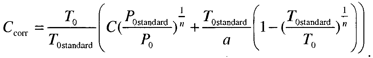
Dans un mode de réalisation de l'invention, le procédé de correction de l'altitude barométrique d'aéronefs décrit ci-dessus peut être caractérisé en ce que les couples de valeurs (C ; H) mémorisés lors de l'étape d'acquisition et de mémorisation sont supprimés s'ils correspondent à des détections à des niveaux d'altitude inférieurs à un premier seuil déterminé et / ou supérieurs à un second seuil déterminé.In one embodiment of the invention, the method for correcting the barometric altitude of aircraft described above can be characterized in that the pairs of values (C; H) stored during the acquisition step and memorization are deleted if they correspond to detections at altitude levels lower than a first determined threshold and / or above a second determined threshold.
Dans un mode de réalisation de l'invention, le procédé de correction de l'altitude barométrique d'aéronefs décrit ci-dessus peut être caractérisé en ce que les deux couples de valeurs (Ci ; Hi) et (Cj ; Hj) sont respectivement les deux couples correspondant aux deux détections de plus basse altitude géométrique H.In one embodiment of the invention, the method for correcting the barometric altitude of aircraft described above can be characterized in that the two pairs of values (C i ; H i ) and (C j ; H j ) are respectively the two pairs corresponding to the two detections of lower geometric altitude H.
Dans un mode de réalisation de l'invention, le procédé de correction de l'altitude barométrique d'aéronefs décrit ci-dessus peut être caractérisé en ce que l'étape de calcul comprend en outre une étape de vérification de la cohérence des valeurs des couples (C ; H) mémorisés pour une cellule donnée, un couple de valeurs (C ; H) étant considéré comme cohérent si la différence entre la valeur corrigée de l'altitude barométrique C et l'altitude géométrique H est inférieure à un seuil déterminé ou incohérent dans le cas contraire ; un ou plusieurs couples de valeurs considérés comme incohérents entraînant le choix de deux couples (Ci ; Hi) et (Cj ; Hj) différents.In one embodiment of the invention, the method for correcting the barometric altitude of aircraft described above can be characterized in that the calculation step further comprises a step of verifying the consistency of the values of the pairs (C; H) stored for a given cell, a pair of values (C; H) being considered coherent if the difference between the corrected value of the barometric altitude C and the geometric altitude H is less than a determined threshold or inconsistent otherwise; one or more pairs of values considered as incoherent leading to the choice of two different pairs (C i ; H i ) and (C j ; H j ).
Dans un mode de réalisation de l'invention, le procédé de correction de l'altitude barométrique d'aéronefs décrit ci-dessus peut être caractérisé en ce que des valeurs de pression et de température au niveau de la mer (P0 ; T0) sont calculées lors de l'étape de calcul, pour toutes les paires de couples de valeurs (C ; H) d'une cellule donnée, l'étape de calcul comprenant un calcul supplémentaire fournissant une moyenne des valeurs (P0 ; T0) calculées et appliquant à la cellule la valeur moyenne du couple (P0 ; T0).In one embodiment of the invention, the method for correcting the barometric altitude of aircraft described above can be characterized in that pressure and temperature values at sea level (P 0 ; T 0 ) are calculated during the calculation step, for all pairs of values (C; H) of a given cell, the calculation step comprising an additional calculation providing an average of the values (P 0 ; T 0 ) calculated and applying to the cell the average value of the torque (P 0 ; T 0 ).
Dans un mode de réalisation de l'invention, le procédé de correction de l'altitude barométrique d'aéronefs décrit ci-dessus peut être caractérisé en ce que l'étape de calcul comprend un calcul supplémentaire des valeurs de pression et de température au niveau de la mer (P0 ; T0) pour des cellules pour lesquelles aucun couple de valeurs (P0 ; T0) n'est attribué et juxtaposées à au moins un nombre déterminé de cellules adjacentes pour lesquelles des valeurs (P0 ; T0) ont été déterminées, le calcul attribuant aux cellules la moyenne barycentrique des valeurs (P0 ; T0) de toutes les cellules adjacentes.In one embodiment of the invention, the method for correcting the barometric altitude of aircraft described above can be characterized in that the calculation step comprises an additional calculation of the pressure and temperature values at the level of the aircraft. of the sea (P 0 ; T 0 ) for cells for which no pair of values (P 0 ; T 0 ) are assigned and juxtaposed to at least a determined number of adjacent cells for which values (P 0 ; T 0 ) have been determined, the calculation assigning the cells the average barycentric values (P 0 ; T 0 ) of all adjacent cells.
Dans un mode de réalisation de l'invention, le procédé de correction de l'altitude barométrique d'aéronefs décrit ci-dessus peut être caractérisé en ce que le nombre déterminé de cellules adjacentes pour lesquelles des valeurs (P0 ; T0) ont été déterminées est égal à 4.In one embodiment of the invention, the method for correcting the barometric altitude of aircraft described above can be characterized in that the determined number of adjacent cells for which values (P 0 ; T 0 ) have been determined is equal to 4.
Dans un mode de réalisation de l'invention, le procédé de correction de l'altitude barométrique d'aéronefs décrit ci-dessus peut être caractérisé en ce qu'aucune valeur du couple (P0 ; T0) n'est calculé pour une cellule donnée lors de l'étape de calcul si le nombre de couples de valeurs (C ; H) mémorisés pour cette cellule est inférieur à un nombre prédéterminé.In one embodiment of the invention, the method for correcting the barometric altitude of aircraft described above can be characterized in that no value of the torque (P 0 ; T 0 ) is calculated for a given cell during the calculation step if the number of pairs of values (C; H) stored for this cell is less than a predetermined number.
Dans un mode de réalisation de l'invention, le procédé de correction de l'altitude barométrique d'aéronefs décrit ci-dessus peut être caractérisé en ce que le nombre prédéterminé de couples de valeurs (C ; H) mémorisés est égal à 5.In one embodiment of the invention, the method for correcting the barometric altitude of aircraft described above can be characterized in that the predetermined number of stored pairs of values (C; H) is equal to 5.
Dans un mode de réalisation de l'invention, le procédé de correction de l'altitude barométrique d'aéronefs décrit ci-dessus peut être caractérisé en ce que les valeurs de pression et de température au niveau de la mer (P0n ; T0n) pour une cellule donnée, telles que calculées lors de l'étape de calcul pour une fenêtre temporelle n, subissent un lissage avec les valeurs (P0n-1 ; T0n-1) déterminées pour la cellule pour une fenêtre temporelle précédente n-1, le lissage attribuant au couple de valeurs (P0; T0) la valeur α.(P0n-1 ; T0n-1) + (1 - α).(P0n ; T0n), α étant un coefficient compris entre 0 et 1.In one embodiment of the invention, the method for correcting the barometric altitude of aircraft described above can be characterized in that the pressure and temperature values at sea level (P 0n ; T 0n ) for a given cell, as calculated during the calculation step for a time window n, are smoothed with the values (P 0n-1 ; T 0n-1 ) determined for the cell for a previous time window n- 1, the smoothing attributing to the pair of values (P 0 ; T 0 ) the value α. (P 0n-1 ; T 0n-1 ) + (1-α). (P 0n ; T 0n ), α being a coefficient between 0 and 1.
L'invention peut enfin avoir pour-objet un système de contrôle du trafic aérien caractérisé en ce qu'il comporte des moyens qui sont adaptés à mettre en oeuvre un procédé de correction de l'altitude d'aéronefs tel que décrit ci-dessus selon divers modes de réalisations de l'invention.The invention may finally have the purpose of an air traffic control system characterized in that it comprises means which are adapted to implement a method of correcting the altitude of aircraft as described above according to various embodiments of the invention.
D'autres caractéristiques et avantages de l'invention apparaîtront à la lecture de la description, donnée à titre d'exemple, faite en regard des dessins annexés qui représentent :
- la
figure 1 , un schéma synoptique de la structure générale d'un système de contrôle du trafic aérien et des différents capteurs impliqués ; - la
figure 2 , un exemple de courbe représentant la correction apportée à une altitude barométrique pour estimer une altitude géométrique, et la répercussion de la correction sur la position d'un aéronef donnée par un radar mode A/C ; - la
figure 3 , un exemple du découpage en cellules du plan stéréographique correspondant à la zone de surveillance dans le cadre du contrôle du trafic aérien ; - la
figure 4 , un ordinogramme représentant le procédé d'estimation d'altitude d'aéronefs selon l'invention ; - la
figure 5 , un diagramme représentant un nuage de couples de valeurs d'altitudes barométriques et géométriques reçues au cours d'une fenêtre temporelle.
- the
figure 1 , a synoptic diagram of the general structure of an air traffic control system and the various sensors involved; - the
figure 2 , an example of a curve representing the correction made to a barometric altitude to estimate a geometric altitude, and the repercussion of the correction on the position of a given aircraft by a radar mode A / C; - the
figure 3 , an example of the division into cells of the stereographic plane corresponding to the surveillance zone in the context of air traffic control; - the
figure 4 a flow chart representing the aircraft altitude estimation method according to the invention; - the
figure 5 , a diagram representing a cloud of pairs of barometric and geometric altitude values received during a time window.
La
Dans l'exemple de la figure, l'aéronef 100 est équipé d'un système ADS-B. Il émet donc périodiquement un signal, ou rapport ADS-B, contenant des informations complémentaires fournies par exemple par un récepteur embarqué de géo-positionnement par satellite. Parmi ces données complémentaires, se trouvent les coordonnées géodésiques de l'aéronef 100, selon le système connu sous l'acronyme de WGS 84, ainsi que son altitude barométrique. Ainsi chaque rapport ADS-B comprend, entre autres données, l'altitude géométrique H de l'aéronef 100 et son altitude barométrique C.In the example of the figure, the
Le taux d'équipement ADS-B des avions de compagnies aériennes est aujourd'hui tel qu'il permet de couvrir les principales zones d'intérêt du trafic aérien. Un but de la présente invention est de mémoriser des couples de données d'altitudes barométriques et d'altitudes géométriques par zones géographiques et par altitudes géométriques ou niveaux de vol, afin de permettre le calcul, à partir d'au moins deux mesures récentes de tels couples, de la température et de la pression au niveau de la mer. Ce calcul permet de réaliser une cartographie météorologique de la zone d'intérêt. Par exemple, un découpage en cellules du plan stéréographique ramené au niveau moyen de la mer peut être réalisé. Par une pluralité de calculs, opérés sur la base de couples (C ; H) obtenus au cours du temps de divers aéronefs, il est possible d'associer à chacune des cellules des valeurs de pression et de température au niveau du sol. Un couple de pression et de température au niveau du sol, que nous noterons par la suite (P0 ; T0), peut être déterminé pour une cellule donnée, dès lors qu'au moins deux couples (C ; H) ont été obtenus d'aéronefs à la verticale de cette cellule. Le calcul des valeurs (P0 ; T0) peut être réalisé à partir de la formule suivante, selon le modèle d'atmosphère de l'Organisation de l'Aviation Civile Internationale (OACI) combinant la relation d'état des gaz parfaits et l'hypothèse hydrostatique : 
- H est l'altitude géométrique,
- C est l'altitude barométrique,
- T0 est la température au niveau de la mer, avec T0standard = 288,15 K,
- P0 est la pression au niveau de la mer, avec P0standard = 1013,25 hPa,
- a est la chute de la température avec l'altitude ; ici a = 0,0065 °C.m-1,
- n = 5,2561
- H is the geometric altitude,
- It is the barometric altitude,
- T 0 is the temperature at sea level, with T standard = 288.15 K,
- P 0 is the pressure at sea level, with P standard = 1013.25 hPa,
- a is the fall of temperature with altitude; here a = 0.0065 ° Cm -1 ,
- n = 5.2561
Ainsi pour une paire de couples (C ; H) notés (Ci ; Hi) et (Cj ; Hj) pour des relevés à la verticale d'une même cellule donnée, la pression et la température au niveau de la mer peuvent s'écrire : 

A partir du moment où des valeurs de pression et de température au niveau de la mer P0 et T0 ont été déterminées pour une cellule donnée, c'est-à-dire initialisées et validées comme explicité ci-après en référence aux
La 
Il est alors possible de reconstruire une détection SSR virtuelle, représentée par un point virtuel 202, situé de même à la distance ρ du SSR, à l'azimut Az, et dont l'altitude est l'altitude barométrique corrigée Ccorr. L'abscisse et l'ordonnée du point virtuel 202 sont notées respectivement xcorr et ycorr.It is then possible to reconstruct a virtual SSR detection, represented by a
Les trois coordonnées du point 202 diffèrent de celles du point 201, et leur précision est améliorée puisque l'altitude barométrique Ccorr correspond au QNH local. Ainsi tous les calculs réalisés sur la base de la position de l'aéronef 100 sont réalisés à partir de la position corrigée correspondant au point virtuel 202, ce qui évite de propager dans ces calculs l'erreur introduite par l'estimation de l'altitude barométrique en référence à la pression de 1013,25 hPa.The three coordinates of
La
Dans un premier exemple, une détection de SSR peut se situer à la verticale de la cellule 302, pour la piste d'un aéronef 100 n'étant pas équipé d'un système ADS-B. L'altitude barométrique donnée par le rapport du mode C peut alors être corrigée en se basant sur les valeurs de pression et de température P0 et T0 déterminées pour cette cellule. Si les valeurs de P0 et T0 n'ont pas pu être déterminées pour cette cellule 302, alors aucune correction n'est appliquée. Avantageusement, si les valeurs de P0 et T0 n'ont pas pu être déterminées pour la cellule 302, mais que des valeurs de pression et de température au niveau de la mer ont pu être déterminées pour des cellules adjacentes 303 à 309, alors des valeurs P0 et T0 peuvent être attribuées par interpolation à la cellule 302. Par exemple, si des valeurs ont été déterminées pour au moins 4 des cellules 303 à 309, alors des valeurs P0 et T0 peuvent être calculées comme le barycentre de toutes les valeurs attribuées aux cellules adjacentes concernées.In a first example, an SSR detection may be located vertically of the
La
A un instant t0, une fenêtre temporelle de détection de durée déterminée démarre, par la réinitialisation d'un compteur de temps. Cette durée peut par exemple durer 20 minutes. Au cours de cette fenêtre temporelle, des rapports ADS-B peuvent être reçus. A la réception d'un rapport ADS-B en provenance d'un aéronef, une première étape 401 a pour but de vérifier si des données d'altitude géométrique et d'altitude barométrique sont comprises dans le rapport. Si tel n'est pas le cas, alors aucune exploitation n'est faite des données reçues.At a time t 0 , a fixed time detection time window starts, by resetting a timer. This duration may for example last 20 minutes. During this time window, ADS-B reports can be received. Upon receipt of an ADS-B report from an aircraft, a
Si de telles données sont présentes dans le rapport, alors une étape 402 suivante a pour but de déterminer la cellule de la grille bidimensionnelle 301 à la verticale de laquelle se trouve l'aéronef dont est issu le rapport ADS-B, au moment de son émission.If such data is present in the report, then a
Lors d'une étape 403 suivante, le couple (C ; H) nouvellement acquis est mémorisé pour la cellule considérée, la mémoire associée à cette cellule est ainsi augmentée d'un couple de valeurs supplémentaires, en plus de couples de valeurs éventuellement acquis précédemment au cours de la fenêtre temporelle courante ou bien au cours de fenêtres temporelles précédentes. Avantageusement, lors d'une étape, non représentée dans la figure, préalable à l'étape de mémorisation 403, il peut être vérifié que le couple de valeurs nouvellement acquis ne présente pas une aberration, pour cause par exemple d'un dysfonctionnement quelconque. Par exemple, il peut être vérifié que la différence entre les données comprises dans le dernier rapport ADS-B et les données comprises dans un ou des rapports ADS-B précédents pour le même aéronef, n'est pas plus importante qu'un seuil déterminé. Un couple présentant une telle aberration peut alors être définitivement discriminé afin de ne pas générer d'erreurs dans les calculs ultérieurs. Cette discrimination peut tout aussi bien être réalisée lors d'une étape ultérieure.During a
Un certain nombre de couples (C ; H) provenant de différents rapports ADS-B pour un ou une pluralité d'aéronefs sont ainsi mémorisés au cours de la fenêtre temporelle de détection. Lorsque la fenêtre temporelle courante est terminée, une fenêtre temporelle de calcul est démarrée.A number of pairs (C; H) from different ADS-B ratios for one or a plurality of aircraft are thus stored during the detection time window. When the current time window is complete, a calculation time window is started.
En parallèle, les données acquises et mémorisées pendant la période qui vient de se terminer, sont traitées lors d'une étape 404. L'étape 404 a pour but de calculer les valeurs P0 et T0 pour toutes les cellules pour lesquelles ce calcul est réalisable, sur la base des relations (2) et (3) explicitées plus haut, et selon une méthode décrite ci-après sur la base d'un exemple, en référence à la
Une fois que les calculs des conditions de pression et de température au niveau de la mer ont été réalisés pour toutes les cellules possibles, les corrections d'altitude barométrique pourront être appliquées pour tous les aéronefs pour lesquels par exemple des détections de radar de surveillance secondaire SSR 102 auront été reçues à la verticale de ces cellules.Once calculations of sea level pressure and temperature conditions have been made for all possible cells, the barometric altitude corrections may be applied for all aircraft for which, for example, secondary surveillance
La
Dans un souci de clarté, la figure se limite à une cellule 302 donnée. Bien sûr, la description ci-après s'applique pour toutes les cellules de la grille bidimensionnelle correspondant à l'espace aérien d'intérêt. En outre, la description ci-après est faite en référence à une fenêtre temporelle d'acquisition des rapports ADS-B, démarrant à l'instant t et se terminant à l'instant t + Δt. Soient (P0n-1 ; T0n-1) les valeurs de pression et de température au niveau de la mer associées à la cellule 302 à l'instant t, issues d'un calcul réalisé à la fin de la fenêtre temporelle de détection précédente ; soient (P0n ; T0n) les valeurs de pression et de température au niveau de la mer associées à la cellule 302 à l'instant t + Δt, c'est-à-dire à l'issue de la fenêtre temporelle de détection courante.For the sake of clarity, the figure is limited to a given
Au cours de la fenêtre temporelle de détection, 6 couples de valeurs (C ; H) sont acquis dans l'exemple de la figure. Ces valeurs sont notées (C1 ; H1) à (C6 ; H6) dans l'ordre chronologique de leur acquisition. Dans un mode de réalisation, seuls les couples (C ; H) acquis au cours de la période temporelle de détection sont utilisés pour le calcul de (P0n ; T0n). Dans un mode alternatif de réalisation, des valeurs acquises lors d'une ou plusieurs fenêtres temporelles précédentes peuvent être utilisées. Avantageusement, chaque couple de valeurs (C ; H) peut être associé à la date de réception du rapport ADS-B correspondant, et un compteur de temps permet d'éliminer les couples de valeurs ayant atteint un âge déterminé, afin qu'elles ne soient plus utilisées dans les calculs.During the detection time window, 6 pairs of values (C; H) are acquired in the example of the figure. These values are noted (C 1 , H 1 ) to (C 6 , H 6 ) in the chronological order of their acquisition. In one embodiment, only the pairs (C; H) acquired during the detection time period are used for the calculation of (P 0n ; T 0n ). In an alternative embodiment, values acquired during one or more previous time slots may be used. Advantageously, each pair of values (C; H) can be associated with the date of receipt of the corresponding ADS-B report, and a time counter Eliminates pairs of values that have reached a certain age so that they are no longer used in calculations.
Un premier couple de valeurs (C ; H) est utilisé comme référence. Par exemple, le couple du niveau d'altitude géométrique le plus bas est utilisé comme référence. Dans l'exemple de la figure, il s'agit du couple de valeurs (C2 ; H2). Avantageusement, les couples de valeurs (C ; H) correspondant à des altitudes géométriques inférieures à un premier seuil d'altitude déterminé, peuvent être éliminés afin de ne pas être utilisés dans les calculs, les altitudes les plus basses étant sujettes à des phénomènes tels que les conditions de l'atmosphère modèle OACI ne peuvent plus y être appliquées en approximation. De la même manière, des couples de valeurs (C ; H) correspondant à des altitudes géométriques supérieures à un second seuil d'altitude déterminé peuvent être éliminés.A first pair of values (C; H) is used as a reference. For example, the pair of the lowest geometric altitude level is used as a reference. In the example of the figure, it is the pair of values (C 2 , H 2 ). Advantageously, the pairs of values (C; H) corresponding to geometric altitudes below a first determined altitude threshold can be eliminated so as not to be used in the calculations, the lowest altitudes being subject to phenomena such as that the conditions of the ICAO model atmosphere can no longer be applied in approximation. Similarly, pairs of values (C; H) corresponding to geometric altitudes above a second altitude threshold determined can be eliminated.
Un second couple de valeurs (C ; H) est utilisé en combinaison avec le premier couple de valeurs, soit (C2 ; H2) dans l'exemple de la figure, afin de calculer le couple de valeurs (P0n ; T0n). Le second couple de valeurs (C ; H) peut par exemple être choisi comme le second couple de niveau d'altitude géométrique le plus bas, soit le couple de valeurs (C3 ; H3) dans l'exemple de la figure.A second pair of values (C; H) is used in combination with the first pair of values, ie (C 2 ; H 2 ) in the example of the figure, in order to calculate the pair of values (P 0n ; T 0n ). The second pair of values (C; H) may for example be chosen as the second lowest geometric altitude level pair, ie the pair of values (C 3 ; H 3 ) in the example of the figure.
Avantageusement, il peut être vérifié que les autres couples de valeurs (C ; H) associés à la cellule 302 présentent des valeurs cohérentes. Cette vérification peut par exemple être réalisée en appliquant à chaque valeur d'altitude barométrique C de chaque couple la correction imposée par le couple de valeurs (P0n ; T0n), et en vérifiant que chaque valeur Ccorr résultant de la correction est suffisamment proche de la valeur H correspondante. Si tel n'est pas le cas, il peut alors par exemple être prévu de choisir deux autres couples de valeurs, par exemple (C5 ; H5) et (C1 ; H1), pour procéder à un nouveau calcul de (P0n; T0n) et à une nouvelle vérification avec les autres couples de valeurs (C ; H), et de procéder ainsi jusqu'à ce qu'une telle vérification s'avère satisfaisante. Dans un mode alternatif de réalisation, il peut être envisagé de procéder à différents calculs de (P0n; T0n) pour toutes les paires de couples possibles par combinaison des couples de valeurs (C ; H) associés à la cellule, puis de procéder à une moyenne des valeurs de pression et de température ainsi déterminées pour obtenir le couple (P0n ; T0n), ou encore il est possible de ne conserver les valeurs (P0n ; T0n) déterminées pour toutes les paires de couples de valeurs (C ; H) possibles qu'à la condition qu'elles soient suffisamment proches des valeurs (P0n-1 ; T0n-1) et / ou qu'elles soient suffisamment proches entre elles. Ces vérifications permettent notamment d'identifier et de s'affranchir d'éventuels effets dépressionnaires pouvant se produire à la verticale de la cellule 302, ou bien d'erreurs plus rares d'origine avionique pouvant conduire à certains rapports ADS-B contenant des valeurs erronées.Advantageously, it can be verified that the other pairs of values (C; H) associated with the
Dans toutes les situations précitées pouvant conduire à l'impossibilité d'effectuer un calcul du couple de valeurs (P0n ; T0n), il peut être envisagé de n'appliquer aucune correction aux altitudes barométriques des détections faites à la verticale de cette cellule, ou bien d'appliquer les valeurs (P0n-1 ; T0n-1), assorties d'une augmentation de la variance sur l'amplitude de la correction.In all the aforementioned situations that may lead to the impossibility of performing a calculation of the pair of values (P 0n ; T 0n ), it may be envisaged to apply no correction to the barometric elevations of the detections made in the vertical of this cell , or else to apply the values (P 0n-1 ; T 0n-1 ), with an increase of the variance over the amplitude of the correction.
Avantageusement les valeurs (P0n ; T0n) peuvent être lissées par rapport aux valeurs (P0n-1 ; T0n-1), par exemple en attribuant au couple de valeurs (P0 ; T0) un couple de valeurs défini par :
- α.(P0n-1; T0n-1) + (1 - α).(P0n; T0n) ; α étant compris entre 0 et 1, et typiquement entre 0,3 et 0,4.
- α (P 0n-1 ; T 0n-1 ) + (1-α). (P 0n ; T 0n ); α being between 0 and 1, and typically between 0.3 and 0.4.
Claims (13)
- A method for correcting the barometric altitude of aircraft (100), characterised in that it comprises the following steps:• a preliminary step of dividing the stereographic plane that corresponds to a surveillance zone into a two-dimensional grid (301) comprising a plurality of cells (302, 304);• a first step of starting a detection time window of a determined duration for detecting ratios of the ADS-B type;for each ratio of the ADS-B type received during said detection time window:• a step (403) of acquiring and of storing pairs of values of barometric altitude and of geometric altitude (C; H) originating from ADS-B ratios associated with the corresponding cells;after the end of said detection time window:• a step of starting a computation time window of a determined duration;• a step (404) of computing pressure and temperature values (P0; T0) at sea level for all of the cells, from all of the pairs (C; H) acquired for said cells during a determined period, and of computing a correction of the barometric altitude from the temperature and pressure values at sea level, for all of the targets detected by at least one sensor, on the vertical line of said cells (302).
- The method for correcting the barometric altitude of aircraft according to claim 1, characterised in that the computation of pressure and temperature values (P0; T0) at sea level that is performed during said computing step (404) at the end of said computation time window is carried out on the basis of two pairs of values (Ci; Hi) and (Cj; Hj) acquired during said detection time window, according to the following formulae:


where:- H is the geometric altitude;- C is the barometric altitude;- T0 is the temperature at sea level, wherein T0standard = 288.15 K;- P0 is the pressure at sea level, wherein P0standard = 1013.25 hPa;- a is the drop in temperature with the altitude, in this case a = 0.0065°C.m-1;- n=5.52561. - The method for correcting the barometric altitude of aircraft according to claim 1, characterised in that said at least one sensor is an A/C mode secondary radar, the correction of the barometric altitude that is performed during said computing step (404) for a detection originating from a secondary surveillance radar providing a barometric altitude that is corrected according to the following formula:

- The method for correcting the barometric altitude of aircraft according to claim 1, characterised in that said pairs of values (C; H), stored during said step (403) of acquiring and storing, are deleted if they correspond to detections at altitude levels below a first determined threshold and/or above a second determined threshold.
- The method for correcting the barometric altitude of aircraft according to any one of claims 2 to 4, characterised in that said two pairs of values (Ci; Hi) and (Cj; Hj) are, respectively, the two pairs that correspond to the two detections at a lower geometric altitude H.
- The method for correcting the barometric altitude of aircraft according to claim 5, characterised in that said computing step (404) further comprises a step of verifying the coherence of the values of the pairs (C; H) that are stored for a given cell (302), with a pair of values (C; H) being considered to be coherent if the difference between the corrected value of the barometric altitude C and the geometric altitude H is below a determined threshold or otherwise is incoherent, with one or more pairs of values that are considered to be incoherent entailing the selection of two different pairs (Ci; Hi) and (Cj; Hj).
- The method for correcting the barometric altitude of aircraft according to claim 1, characterised in that pressure and temperature values at sea level (P0; T0) are computed during said computing step (404), for all of the sets of pairs of values (C; H) of a given cell (302), said computing step (404) comprising an additional computation providing a mean of the computed values (P0; T0) and applying the mean value of the pair (P0; T0) to said cell (302).
- The method for correcting the barometric altitude of aircraft according to claim 1, characterised in that said computing step (404) comprises an additional computation of the pressure and temperature values (P0; T0) at sea level for cells for which no pair of values (P0; T0) is assigned and juxtaposed to at least one determined number of adjacent cells, for which values (P0; T0) have been determined, said computation assigning the barycentric mean of the values (P0; T0) of all of the adjacent cells to said cells.
- The method for correcting the barometric altitude of aircraft according to claim 8, characterised in that the determined number of adjacent cells, for which values (P0; T0) have been determined, is 4.
- The method for correcting the barometric altitude of aircraft according to any one of the preceding claims, characterised in that no value of the pair (P0; T0) is computed for a given cell (302) during said computing step (404) if the number of pairs of values (C; H) stored for said cell (302) is less than a predetermined number.
- The method for correcting the barometric altitude of aircraft according to claim 10, characterised in that the predetermined number of pairs of stored values (C; H) is 5.
- The method for correcting the barometric altitude of aircraft according to any one of the preceding claims, characterised in that the pressure and temperature values at sea level (P0n; T0n) for a given cell (302), as computed during said computing step (404) for a time window n, are smoothed with the values (P0n-1; T0n-1) determined for said cell (302) for a preceding time window n-1, said smoothing assigning the value α(P0n-1; T0n-1) + (1-α).(P0n; T0n) to said pair of values (P0; T0), with α being a coefficient between 0 and 1.
- An air traffic control system, characterised in that it comprises means that are designed to implement a method for correcting the altitude of aircraft according to any one of the preceding claims.
Applications Claiming Priority (2)
| Application Number | Priority Date | Filing Date | Title |
|---|---|---|---|
| FR0807060A FR2939945B1 (en) | 2008-12-16 | 2008-12-16 | METHOD FOR CORRECTING THE BAROMETRIC ALTITUDE OF AIRCRAFT IMPLEMENTED IN A SYSTEM FOR CONTROLLING AIR TRAFFIC |
| PCT/EP2009/067114 WO2010069934A1 (en) | 2008-12-16 | 2009-12-14 | Method of correcting the barometric altitude of aircraft implemented in an air traffic control system |
Publications (2)
| Publication Number | Publication Date |
|---|---|
| EP2366094A1 EP2366094A1 (en) | 2011-09-21 |
| EP2366094B1 true EP2366094B1 (en) | 2015-04-01 |
Family
ID=41052980
Family Applications (1)
| Application Number | Title | Priority Date | Filing Date |
|---|---|---|---|
| EP09775186.1A Active EP2366094B1 (en) | 2008-12-16 | 2009-12-14 | Method with pressure altitude correction for an aircraft |
Country Status (4)
| Country | Link |
|---|---|
| EP (1) | EP2366094B1 (en) |
| ES (1) | ES2540765T3 (en) |
| FR (1) | FR2939945B1 (en) |
| WO (1) | WO2010069934A1 (en) |
Families Citing this family (4)
| Publication number | Priority date | Publication date | Assignee | Title |
|---|---|---|---|---|
| FR2963119B1 (en) | 2010-07-20 | 2015-05-01 | Airbus Operations Sas | METHOD AND DEVICE FOR RECALING TARGET ALTITUDE FOR EMERGENCY DESCENT OF AN AIRCRAFT |
| CN110621960B (en) | 2017-08-25 | 2022-03-22 | 深圳市大疆创新科技有限公司 | Altitude estimation for aircraft |
| US10591293B2 (en) | 2018-08-07 | 2020-03-17 | Honeywell International Inc. | Detecting an incorrect altimeter setting |
| DE102020128793A1 (en) | 2020-11-02 | 2022-05-05 | Becker Avionics Gmbh | Procedure for controlling a flight obstacle beacon |
Family Cites Families (6)
| Publication number | Priority date | Publication date | Assignee | Title |
|---|---|---|---|---|
| US5402116A (en) * | 1992-04-28 | 1995-03-28 | Hazeltine Corp. | Atmospheric pressure calibration systems and methods |
| US7429950B2 (en) * | 1999-03-05 | 2008-09-30 | Era Systems Corporation | Method and apparatus to extend ADS performance metrics |
| US7423590B2 (en) * | 1999-03-05 | 2008-09-09 | Era Systems Corporation | Method and apparatus for improving ADS-B security |
| US6799114B2 (en) * | 2001-11-20 | 2004-09-28 | Garmin At, Inc. | Systems and methods for correlation in an air traffic control system of interrogation-based target positional data and GPS-based intruder positional data |
| GB0424491D0 (en) * | 2004-11-05 | 2004-12-08 | Qinetiq Ltd | Airspace separation control and collision avoidance |
| US7389164B1 (en) * | 2007-01-22 | 2008-06-17 | Honeywell International, Inc. | Systems and methods for automatic detection of QFE operations |
-
2008
- 2008-12-16 FR FR0807060A patent/FR2939945B1/en not_active Expired - Fee Related
-
2009
- 2009-12-14 WO PCT/EP2009/067114 patent/WO2010069934A1/en active Application Filing
- 2009-12-14 ES ES09775186.1T patent/ES2540765T3/en active Active
- 2009-12-14 EP EP09775186.1A patent/EP2366094B1/en active Active
Also Published As
| Publication number | Publication date |
|---|---|
| FR2939945A1 (en) | 2010-06-18 |
| FR2939945B1 (en) | 2011-02-11 |
| WO2010069934A1 (en) | 2010-06-24 |
| EP2366094A1 (en) | 2011-09-21 |
| ES2540765T3 (en) | 2015-07-13 |
Similar Documents
| Publication | Publication Date | Title |
|---|---|---|
| EP2922040B1 (en) | Driving of vehicles in a convoy | |
| EP2202534B1 (en) | Processing method of multi-sensor tracking with reduced latency period | |
| EP2511729B1 (en) | Method for locating aircraft independently from any satellite navigation system | |
| WO2009112483A1 (en) | Device and method for the real-time monitoring of the integrity of a satellite navigation system | |
| EP3844529B1 (en) | Method for characterizing the density of mode s interrogations and reponses and secondary radar implementing such a method | |
| EP1095362B1 (en) | Device for improving the security of aircraft in visual flight regime | |
| EP2366094B1 (en) | Method with pressure altitude correction for an aircraft | |
| EP3049762B1 (en) | Method for calculating the surface vector of at least one ship and method for estimating its drift vector on each point of its trajectory | |
| EP2799890B1 (en) | Method and system for determining the speed of an aircraft relative to the air | |
| WO2020016150A1 (en) | Method of locating a vehicle | |
| EP2804016B1 (en) | Improved method for determining the position and/or the speed of a guided vehicle; related system | |
| EP1299746B1 (en) | Method for secure determination of an object location, preferably a vehicle moving along a known course | |
| EP2367025B1 (en) | Method and system for verifying the precision performance of a satellite navigation system | |
| FR2916060A1 (en) | METHOD AND DEVICE FOR MONITORING A HORIZONTAL POSITION OF AN AIRCRAFT ON THE GROUND | |
| FR2912221A1 (en) | Mobile body e.g. aircraft, position and protection limit determining method, involves comparing protection limits for retaining greater limit as valid protection limit for readjusted position | |
| EP3657210A1 (en) | Method and system for navigating an aircraft | |
| WO2021009033A1 (en) | Method and device for detecting a decoy operation of a gnss system | |
| EP2367024B1 (en) | Calculation method and system for assessing the precision performance of a satellite navigation system | |
| FR2756960A1 (en) | Device fitted to aircraft to reduce risk of mid-air collision | |
| FR2853062A1 (en) | NAVIGATION AID INCREASED IN VERTICAL INTEGRITY | |
| FR3122739A1 (en) | Method of navigation with resetting on neighboring aircraft | |
| WO2022089894A1 (en) | Rnp navigation without gnss | |
| WO2023180143A1 (en) | Method for determining at least one protection radius associated with at least one navigation parameter, and associated electronic determination device | |
| FR3121983A1 (en) | Automatic adaptation of the vertical profile of an aircraft according to a position uncertainty |
Legal Events
| Date | Code | Title | Description |
|---|---|---|---|
| PUAI | Public reference made under article 153(3) epc to a published international application that has entered the european phase |
Free format text: ORIGINAL CODE: 0009012 |
|
| 17P | Request for examination filed |
Effective date: 20110608 |
|
| AK | Designated contracting states |
Kind code of ref document: A1 Designated state(s): AT BE BG CH CY CZ DE DK EE ES FI FR GB GR HR HU IE IS IT LI LT LU LV MC MK MT NL NO PL PT RO SE SI SK SM TR |
|
| RIN1 | Information on inventor provided before grant (corrected) |
Inventor name: HONORE, NICOLAS Inventor name: BAUD, OLIVIER |
|
| DAX | Request for extension of the european patent (deleted) | ||
| GRAP | Despatch of communication of intention to grant a patent |
Free format text: ORIGINAL CODE: EPIDOSNIGR1 |
|
| INTG | Intention to grant announced |
Effective date: 20141112 |
|
| GRAS | Grant fee paid |
Free format text: ORIGINAL CODE: EPIDOSNIGR3 |
|
| GRAA | (expected) grant |
Free format text: ORIGINAL CODE: 0009210 |
|
| AK | Designated contracting states |
Kind code of ref document: B1 Designated state(s): AT BE BG CH CY CZ DE DK EE ES FI FR GB GR HR HU IE IS IT LI LT LU LV MC MK MT NL NO PL PT RO SE SI SK SM TR |
|
| REG | Reference to a national code |
Ref country code: GB Ref legal event code: FG4D Free format text: NOT ENGLISH |
|
| REG | Reference to a national code |
Ref country code: CH Ref legal event code: EP |
|
| REG | Reference to a national code |
Ref country code: IE Ref legal event code: FG4D Free format text: LANGUAGE OF EP DOCUMENT: FRENCH |
|
| REG | Reference to a national code |
Ref country code: AT Ref legal event code: REF Ref document number: 719330 Country of ref document: AT Kind code of ref document: T Effective date: 20150515 |
|
| REG | Reference to a national code |
Ref country code: DE Ref legal event code: R096 Ref document number: 602009030365 Country of ref document: DE Effective date: 20150521 |
|
| REG | Reference to a national code |
Ref country code: ES Ref legal event code: FG2A Ref document number: 2540765 Country of ref document: ES Kind code of ref document: T3 Effective date: 20150713 |
|
| REG | Reference to a national code |
Ref country code: NL Ref legal event code: VDEP Effective date: 20150401 |
|
| REG | Reference to a national code |
Ref country code: AT Ref legal event code: MK05 Ref document number: 719330 Country of ref document: AT Kind code of ref document: T Effective date: 20150401 |
|
| REG | Reference to a national code |
Ref country code: LT Ref legal event code: MG4D |
|
| PG25 | Lapsed in a contracting state [announced via postgrant information from national office to epo] |
Ref country code: NL Free format text: LAPSE BECAUSE OF FAILURE TO SUBMIT A TRANSLATION OF THE DESCRIPTION OR TO PAY THE FEE WITHIN THE PRESCRIBED TIME-LIMIT Effective date: 20150401 |
|
| PG25 | Lapsed in a contracting state [announced via postgrant information from national office to epo] |
Ref country code: LT Free format text: LAPSE BECAUSE OF FAILURE TO SUBMIT A TRANSLATION OF THE DESCRIPTION OR TO PAY THE FEE WITHIN THE PRESCRIBED TIME-LIMIT Effective date: 20150401 Ref country code: CZ Free format text: LAPSE BECAUSE OF FAILURE TO SUBMIT A TRANSLATION OF THE DESCRIPTION OR TO PAY THE FEE WITHIN THE PRESCRIBED TIME-LIMIT Effective date: 20150401 Ref country code: PT Free format text: LAPSE BECAUSE OF FAILURE TO SUBMIT A TRANSLATION OF THE DESCRIPTION OR TO PAY THE FEE WITHIN THE PRESCRIBED TIME-LIMIT Effective date: 20150803 Ref country code: FI Free format text: LAPSE BECAUSE OF FAILURE TO SUBMIT A TRANSLATION OF THE DESCRIPTION OR TO PAY THE FEE WITHIN THE PRESCRIBED TIME-LIMIT Effective date: 20150401 Ref country code: HR Free format text: LAPSE BECAUSE OF FAILURE TO SUBMIT A TRANSLATION OF THE DESCRIPTION OR TO PAY THE FEE WITHIN THE PRESCRIBED TIME-LIMIT Effective date: 20150401 Ref country code: NO Free format text: LAPSE BECAUSE OF FAILURE TO SUBMIT A TRANSLATION OF THE DESCRIPTION OR TO PAY THE FEE WITHIN THE PRESCRIBED TIME-LIMIT Effective date: 20150701 |
|
| REG | Reference to a national code |
Ref country code: FR Ref legal event code: PLFP Year of fee payment: 7 |
|
| PG25 | Lapsed in a contracting state [announced via postgrant information from national office to epo] |
Ref country code: IS Free format text: LAPSE BECAUSE OF FAILURE TO SUBMIT A TRANSLATION OF THE DESCRIPTION OR TO PAY THE FEE WITHIN THE PRESCRIBED TIME-LIMIT Effective date: 20150801 Ref country code: AT Free format text: LAPSE BECAUSE OF FAILURE TO SUBMIT A TRANSLATION OF THE DESCRIPTION OR TO PAY THE FEE WITHIN THE PRESCRIBED TIME-LIMIT Effective date: 20150401 Ref country code: GR Free format text: LAPSE BECAUSE OF FAILURE TO SUBMIT A TRANSLATION OF THE DESCRIPTION OR TO PAY THE FEE WITHIN THE PRESCRIBED TIME-LIMIT Effective date: 20150702 Ref country code: LV Free format text: LAPSE BECAUSE OF FAILURE TO SUBMIT A TRANSLATION OF THE DESCRIPTION OR TO PAY THE FEE WITHIN THE PRESCRIBED TIME-LIMIT Effective date: 20150401 |
|
| REG | Reference to a national code |
Ref country code: DE Ref legal event code: R097 Ref document number: 602009030365 Country of ref document: DE |
|
| PG25 | Lapsed in a contracting state [announced via postgrant information from national office to epo] |
Ref country code: EE Free format text: LAPSE BECAUSE OF FAILURE TO SUBMIT A TRANSLATION OF THE DESCRIPTION OR TO PAY THE FEE WITHIN THE PRESCRIBED TIME-LIMIT Effective date: 20150401 Ref country code: DK Free format text: LAPSE BECAUSE OF FAILURE TO SUBMIT A TRANSLATION OF THE DESCRIPTION OR TO PAY THE FEE WITHIN THE PRESCRIBED TIME-LIMIT Effective date: 20150401 |
|
| PLBE | No opposition filed within time limit |
Free format text: ORIGINAL CODE: 0009261 |
|
| STAA | Information on the status of an ep patent application or granted ep patent |
Free format text: STATUS: NO OPPOSITION FILED WITHIN TIME LIMIT |
|
| PG25 | Lapsed in a contracting state [announced via postgrant information from national office to epo] |
Ref country code: RO Free format text: LAPSE BECAUSE OF NON-PAYMENT OF DUE FEES Effective date: 20150401 Ref country code: PL Free format text: LAPSE BECAUSE OF FAILURE TO SUBMIT A TRANSLATION OF THE DESCRIPTION OR TO PAY THE FEE WITHIN THE PRESCRIBED TIME-LIMIT Effective date: 20150401 Ref country code: SK Free format text: LAPSE BECAUSE OF FAILURE TO SUBMIT A TRANSLATION OF THE DESCRIPTION OR TO PAY THE FEE WITHIN THE PRESCRIBED TIME-LIMIT Effective date: 20150401 |
|
| 26N | No opposition filed |
Effective date: 20160105 |
|
| PG25 | Lapsed in a contracting state [announced via postgrant information from national office to epo] |
Ref country code: BE Free format text: LAPSE BECAUSE OF NON-PAYMENT OF DUE FEES Effective date: 20151231 Ref country code: SI Free format text: LAPSE BECAUSE OF FAILURE TO SUBMIT A TRANSLATION OF THE DESCRIPTION OR TO PAY THE FEE WITHIN THE PRESCRIBED TIME-LIMIT Effective date: 20150401 |
|
| PG25 | Lapsed in a contracting state [announced via postgrant information from national office to epo] |
Ref country code: MC Free format text: LAPSE BECAUSE OF FAILURE TO SUBMIT A TRANSLATION OF THE DESCRIPTION OR TO PAY THE FEE WITHIN THE PRESCRIBED TIME-LIMIT Effective date: 20150401 Ref country code: LU Free format text: LAPSE BECAUSE OF FAILURE TO SUBMIT A TRANSLATION OF THE DESCRIPTION OR TO PAY THE FEE WITHIN THE PRESCRIBED TIME-LIMIT Effective date: 20151214 |
|
| REG | Reference to a national code |
Ref country code: CH Ref legal event code: PL |
|
| REG | Reference to a national code |
Ref country code: IE Ref legal event code: MM4A |
|
| PG25 | Lapsed in a contracting state [announced via postgrant information from national office to epo] |
Ref country code: CH Free format text: LAPSE BECAUSE OF NON-PAYMENT OF DUE FEES Effective date: 20151231 Ref country code: LI Free format text: LAPSE BECAUSE OF NON-PAYMENT OF DUE FEES Effective date: 20151231 Ref country code: IE Free format text: LAPSE BECAUSE OF NON-PAYMENT OF DUE FEES Effective date: 20151214 |
|
| REG | Reference to a national code |
Ref country code: FR Ref legal event code: PLFP Year of fee payment: 8 |
|
| PG25 | Lapsed in a contracting state [announced via postgrant information from national office to epo] |
Ref country code: SM Free format text: LAPSE BECAUSE OF FAILURE TO SUBMIT A TRANSLATION OF THE DESCRIPTION OR TO PAY THE FEE WITHIN THE PRESCRIBED TIME-LIMIT Effective date: 20150401 Ref country code: HU Free format text: LAPSE BECAUSE OF FAILURE TO SUBMIT A TRANSLATION OF THE DESCRIPTION OR TO PAY THE FEE WITHIN THE PRESCRIBED TIME-LIMIT; INVALID AB INITIO Effective date: 20091214 Ref country code: BG Free format text: LAPSE BECAUSE OF FAILURE TO SUBMIT A TRANSLATION OF THE DESCRIPTION OR TO PAY THE FEE WITHIN THE PRESCRIBED TIME-LIMIT Effective date: 20150401 |
|
| PG25 | Lapsed in a contracting state [announced via postgrant information from national office to epo] |
Ref country code: SE Free format text: LAPSE BECAUSE OF FAILURE TO SUBMIT A TRANSLATION OF THE DESCRIPTION OR TO PAY THE FEE WITHIN THE PRESCRIBED TIME-LIMIT Effective date: 20150401 Ref country code: CY Free format text: LAPSE BECAUSE OF FAILURE TO SUBMIT A TRANSLATION OF THE DESCRIPTION OR TO PAY THE FEE WITHIN THE PRESCRIBED TIME-LIMIT Effective date: 20150401 |
|
| PG25 | Lapsed in a contracting state [announced via postgrant information from national office to epo] |
Ref country code: TR Free format text: LAPSE BECAUSE OF FAILURE TO SUBMIT A TRANSLATION OF THE DESCRIPTION OR TO PAY THE FEE WITHIN THE PRESCRIBED TIME-LIMIT Effective date: 20150401 Ref country code: MT Free format text: LAPSE BECAUSE OF FAILURE TO SUBMIT A TRANSLATION OF THE DESCRIPTION OR TO PAY THE FEE WITHIN THE PRESCRIBED TIME-LIMIT Effective date: 20150401 |
|
| REG | Reference to a national code |
Ref country code: FR Ref legal event code: PLFP Year of fee payment: 9 |
|
| PG25 | Lapsed in a contracting state [announced via postgrant information from national office to epo] |
Ref country code: MK Free format text: LAPSE BECAUSE OF FAILURE TO SUBMIT A TRANSLATION OF THE DESCRIPTION OR TO PAY THE FEE WITHIN THE PRESCRIBED TIME-LIMIT Effective date: 20150401 |
|
| PGFP | Annual fee paid to national office [announced via postgrant information from national office to epo] |
Ref country code: GB Payment date: 20231116 Year of fee payment: 15 |
|
| PGFP | Annual fee paid to national office [announced via postgrant information from national office to epo] |
Ref country code: IT Payment date: 20231128 Year of fee payment: 15 Ref country code: FR Payment date: 20231122 Year of fee payment: 15 Ref country code: DE Payment date: 20231114 Year of fee payment: 15 |
|
| PGFP | Annual fee paid to national office [announced via postgrant information from national office to epo] |
Ref country code: ES Payment date: 20240112 Year of fee payment: 15 |