EP2280244A1 - Method for simulating navigation route, navigation apparatus and computer program product - Google Patents
Method for simulating navigation route, navigation apparatus and computer program product Download PDFInfo
- Publication number
- EP2280244A1 EP2280244A1 EP10170963A EP10170963A EP2280244A1 EP 2280244 A1 EP2280244 A1 EP 2280244A1 EP 10170963 A EP10170963 A EP 10170963A EP 10170963 A EP10170963 A EP 10170963A EP 2280244 A1 EP2280244 A1 EP 2280244A1
- Authority
- EP
- European Patent Office
- Prior art keywords
- navigation
- route
- icon
- navigation route
- speed
- Prior art date
- Legal status (The legal status is an assumption and is not a legal conclusion. Google has not performed a legal analysis and makes no representation as to the accuracy of the status listed.)
- Granted
Links
- 238000000034 method Methods 0.000 title claims abstract description 43
- 238000004590 computer program Methods 0.000 title claims description 8
- 238000004088 simulation Methods 0.000 claims abstract description 59
- 230000000694 effects Effects 0.000 claims abstract description 24
- 241001300198 Caperonia palustris Species 0.000 claims description 7
- 235000000384 Veronica chamaedrys Nutrition 0.000 claims description 7
- 230000008569 process Effects 0.000 claims description 5
- 238000004891 communication Methods 0.000 claims description 4
- 238000004091 panning Methods 0.000 claims description 3
- 238000010586 diagram Methods 0.000 description 2
- 230000003213 activating effect Effects 0.000 description 1
- 239000004973 liquid crystal related substance Substances 0.000 description 1
- 238000010295 mobile communication Methods 0.000 description 1
- 238000012986 modification Methods 0.000 description 1
- 230000004048 modification Effects 0.000 description 1
- 230000008520 organization Effects 0.000 description 1
Images


Classifications
-
- G—PHYSICS
- G01—MEASURING; TESTING
- G01C—MEASURING DISTANCES, LEVELS OR BEARINGS; SURVEYING; NAVIGATION; GYROSCOPIC INSTRUMENTS; PHOTOGRAMMETRY OR VIDEOGRAMMETRY
- G01C21/00—Navigation; Navigational instruments not provided for in groups G01C1/00 - G01C19/00
- G01C21/26—Navigation; Navigational instruments not provided for in groups G01C1/00 - G01C19/00 specially adapted for navigation in a road network
- G01C21/34—Route searching; Route guidance
- G01C21/36—Input/output arrangements for on-board computers
- G01C21/3626—Details of the output of route guidance instructions
- G01C21/3635—Guidance using 3D or perspective road maps
-
- G—PHYSICS
- G01—MEASURING; TESTING
- G01C—MEASURING DISTANCES, LEVELS OR BEARINGS; SURVEYING; NAVIGATION; GYROSCOPIC INSTRUMENTS; PHOTOGRAMMETRY OR VIDEOGRAMMETRY
- G01C21/00—Navigation; Navigational instruments not provided for in groups G01C1/00 - G01C19/00
- G01C21/26—Navigation; Navigational instruments not provided for in groups G01C1/00 - G01C19/00 specially adapted for navigation in a road network
- G01C21/34—Route searching; Route guidance
- G01C21/36—Input/output arrangements for on-board computers
- G01C21/3667—Display of a road map
- G01C21/3676—Overview of the route on the road map
-
- G—PHYSICS
- G08—SIGNALLING
- G08G—TRAFFIC CONTROL SYSTEMS
- G08G1/00—Traffic control systems for road vehicles
- G08G1/09—Arrangements for giving variable traffic instructions
- G08G1/0962—Arrangements for giving variable traffic instructions having an indicator mounted inside the vehicle, e.g. giving voice messages
- G08G1/0968—Systems involving transmission of navigation instructions to the vehicle
- G08G1/096805—Systems involving transmission of navigation instructions to the vehicle where the transmitted instructions are used to compute a route
- G08G1/096827—Systems involving transmission of navigation instructions to the vehicle where the transmitted instructions are used to compute a route where the route is computed onboard
-
- G—PHYSICS
- G08—SIGNALLING
- G08G—TRAFFIC CONTROL SYSTEMS
- G08G1/00—Traffic control systems for road vehicles
- G08G1/09—Arrangements for giving variable traffic instructions
- G08G1/0962—Arrangements for giving variable traffic instructions having an indicator mounted inside the vehicle, e.g. giving voice messages
- G08G1/0968—Systems involving transmission of navigation instructions to the vehicle
- G08G1/096833—Systems involving transmission of navigation instructions to the vehicle where different aspects are considered when computing the route
- G08G1/09685—Systems involving transmission of navigation instructions to the vehicle where different aspects are considered when computing the route where the complete route is computed only once and not updated
-
- G—PHYSICS
- G08—SIGNALLING
- G08G—TRAFFIC CONTROL SYSTEMS
- G08G1/00—Traffic control systems for road vehicles
- G08G1/09—Arrangements for giving variable traffic instructions
- G08G1/0962—Arrangements for giving variable traffic instructions having an indicator mounted inside the vehicle, e.g. giving voice messages
- G08G1/0968—Systems involving transmission of navigation instructions to the vehicle
- G08G1/096855—Systems involving transmission of navigation instructions to the vehicle where the output is provided in a suitable form to the driver
- G08G1/096866—Systems involving transmission of navigation instructions to the vehicle where the output is provided in a suitable form to the driver where the complete route is shown to the driver
Definitions
- the conventional navigation apparatus has a built-in smart electronic map and can execute functions of route planning and navigation.
- the user is only required to input a name or a coordinate of a destination to be leave for, or directly select a particular location on the electronic map, and then the navigation apparatus automatically plans a navigation route based on the detected location and a geographical location of the destination input by the user, and delivers a voice message to guide the user to the destination along the planned navigation route.
- the map displayed by the navigation apparatus may cover a larger range and is not able to reveal the details of the map.
- the navigation apparatus adjusts the display scale of the map and navigation route to the area nearby the apparatus, so as to increase the readability of the map.
- the navigation apparatus can only display a portion of the navigation route when executing the navigation function.
- the user if the user intends to browse the whole navigation route, the user has to adjust the display scale of the map manually. Even if the adjusted map can show the whole navigation route, the user still cannot know the actual road condition, such as where to make a turn or where it is jammed. Therefore, there is a need to provide a navigation route simulation method that can truly reflect the actual road condition, such that the user can activate freely to catch the whole and actual road condition.
- the application is directed to a method for simulating navigation route, which adjusts a moving speed of the navigation icon according to the type or the state of the path, so as to simulate the actual road condition.
- the application is also directed to a navigation apparatus, in which the moving speed of a navigation icon is reduced when encountering a turning point or a jammed section, so as to remind the user of paying attention.
- the application provides a method for simulating a navigation route, suitable for a mobile device having a screen.
- a navigation route is planned and displayed on an electronic map.
- a route simulation mode is entered, an effect of moving a navigation icon along the navigation route from a spot of the navigation route is generated.
- the navigation icon is moved on a straight path of the navigation route, the navigation icon is moved in a first speed; and when the navigation icon is moved on a turning point of the navigation route, the navigation icon is moved in a second speed, in which the second speed is less than the first speed.
- the step of displaying the navigation route on the electronic map comprises only displaying a portion of the navigation route nearby the spot according to a display scale of the electronic map.
- the step of displaying the navigation route on the electronic map further comprises displaying a thumbnail of the navigation route on the electronic map, in which the thumbnail comprises a start point, an end point and a path of the navigation route, and comprises a mark indicating a current location of the navigation icon.
- the step of entering the route simulation mode comprises receiving an operation of a user for the thumbnail and activating the route simulation mode accordingly, so as to display and move the navigation icon.
- the step of generating the effect of moving the navigation icon along the navigation route from the spot of the navigation route further comprises receiving an operation of a user for the screen and closing the route simulation mode accordingly, so as to resume the originally displayed navigation route.
- the step of receiving the operation of the user for the screen comprises receiving the operation of the user for the thumbnail displayed on the screen.
- the method further comprises closing the route simulation mode to resume the originally displayed navigation route when the navigation icon arrives at an end point of the navigation route.
- the step of generating the effect of moving the navigation icon along the navigation route from the spot of the navigation route comprises panning the electronic map and keeping a location of the navigation icon on the screen unchanged according to the navigation route, so as to generate the effect of moving the navigation icon along the navigation route.
- the method further receives information of a jammed section on the navigation route and displays the same on the electronic map, in which the step of generating the effect of moving the navigation icon along the navigation route further comprises moving the navigation icon in a third speed when the navigation icon is moved on the jammed section of the navigation route, wherein the third speed is less than the first speed.
- the step of displaying the navigation route on the electronic map comprises displaying the electronic map in a form of a three-dimensional bird eye view or a two-dimensional plan, and displaying the navigation route on the electronic map.
- the navigation icon is displayed in a form of floating above of the navigation route.
- the step of generating the effect of moving the navigation icon in the second speed when the navigation icon is moved on the turning point of the navigation route further comprises tilting the electronic map to the right by a tilting angle when the navigation icon is moved on a left-turning point of the navigation route and tilting the electronic map to the left by the tilting angle when the navigation icon is moved on a right-turning point of the navigation route.
- the spot where the route simulation mode starts is the start point of the navigation route or a current location of the mobile device.
- the application provides a navigation apparatus comprising a display unit, an input unit, and a processing unit.
- the display unit is used to display an electronic map.
- the input unit is used to receive an operation of a user.
- the processing unit is coupled to the display unit and the input unit, and is used for planning a navigation route, displaying the navigation route on the electronic map, and entering a route simulation mode to generate an effect of moving a navigation icon along the navigation route from a spot of the navigation route when the input unit receives the operation.
- the navigation icon is moved on a straight path of the navigation route
- the navigation icon is moved in a first speed
- the navigation icon is moved on a turning point of the navigation route
- the navigation icon is moved in a second speed, in which the second speed is less than the first speed.
- the present application further provides a computer program product which comprises instructions to be loaded into a mobile device to execute following steps.
- a navigation route is planned and displayed on an electronic map.
- a route simulation mode is entered, an effect of moving a navigation icon along the navigation route from a spot of the navigation route is generated.
- the navigation icon is moved on a straight path of the navigation route, the navigation icon is moved in a first speed; and when the navigation icon is moved on a turning point of the navigation route, the navigation icon is moved in a second speed, in which the second speed is less than the first speed.
- the method for simulating the navigation route, the navigation apparatus, and the computer program product of the application simulate the navigation route by moving a navigation icon, in which the navigation icon is moved in a faster speed when moving on a straight path and moved in a slower speed when moving on a turning point or a jammed section, such that the simulation of the navigation route may reveal actual road condition.
- Fig. 1 is a block diagram of a navigation apparatus according to an example of the present application.
- FIG. 2 is a flowchart showing a method for simulating a navigation route according to an example of the present application.
- FIG. 3 is an example of navigation route simulation according to an example of the present application.
- FIG. 4 is an example of navigation route simulation according to an example of the present application.
- FIG. 5 is a flowchart showing a method for simulating a navigation route according to an example of the present application.
- FIG. 6 is an example of navigation route simulation according to an example of the present application.
- FIG. 7 is a flowchart showing a method for simulating a navigation route according to an example of the present application.
- FIG. 8 is an example of navigation route simulation according to an example of the present application.
- the application provides users with ease to freely activate a simulation for the navigation route in the process of the navigation apparatus executing the navigation function.
- the application adaptively adjusts a moving speed of the navigation icon according to the type or the state of the path passed by the navigation icon, so as to remind the user of paying attention and to enhance the impression of the user.
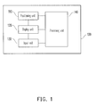
- Fig. 1 is a block diagram of a navigation apparatus according to an example of the present application.
- the navigation apparatus 100 comprises a positioning unit 110, a display unit 120, an input unit 130, and a processing unit 140, and is able to provide simulation function of the navigation route and provide users with ease to preview the navigation route.
- the navigation apparatus 100 is, for example, a mobile phone, a smartphone, a personal digital assistant (PDA), a PDA phone, a car PC, a notebook, a multimedia player, or a handheld gamer.
- PDA personal digital assistant
- the functions of aforesaid elements are respectively described as follows.
- the positioning unit 110 is used for obtaining a current location of the navigation apparatus 100, and is, for example, a global positioning system (GPS), or other positioning systems using a global system for mobile communication (GSM) system, a personal handy-phone system (PHS), a code division multiple access (CDMA) system, a wireless fidelity (Wi-Fi) system, a worldwide interoperability for microwave access (WiMAX) system, a radio repeater, or a radio broadcaster for performing positioning, which is not limited by the present example.
- GPS global positioning system
- GSM global system for mobile communication
- PHS personal handy-phone system
- CDMA code division multiple access
- Wi-Fi wireless fidelity
- WiMAX worldwide interoperability for microwave access
- radio repeater or a radio broadcaster for performing positioning, which is not limited by the present example.
- the display unit 120 is, for example, a liquid crystal display (LCD), a light emitting diode (LED) display, an organic light emitting diode (OLED) display, a field emission display (FED), and/or other displays suitable for displaying the navigation frame.
- LCD liquid crystal display
- LED light emitting diode
- OLED organic light emitting diode
- FED field emission display
- the input unit 130 is, for example, a mouse, a keyboard, a joystick, or a touch pad, and is used for receiving an operation of a user for planning a navigation route.
- the input unit 130 is, for example, a resistive type, a capacitive type, or other types of touch sensitive units, and is able to be integrated with the display unit 120 to form a touch screen.
- the processing unit 140 is, for example, a central processing unit (CPU), or other programmable ordinarily-used or specifically-used microprocessor, digital signal processor (DSP), programmable controller, application specific integrated circuit (ASIC), programmable logic device (PLD), or other similar devices or a combination of those devices.
- CPU central processing unit
- DSP digital signal processor
- ASIC application specific integrated circuit
- PLD programmable logic device
- the processing unit 140 is coupled to the positioning unit 110, the display unit 120 and the input unit 130, and is able to plan a navigation route according to an operation received by the input unit 130 and to execute a simulation function of the navigation route. Examples are given below for illustrating detailed steps of the navigation apparatus 100 simulating the navigation route.
- FIG. 2 is a flowchart showing a method for simulating a navigation route according to an example of the present application.
- the method of the example is suitable for the navigation apparatus 100 in FIG. 1 , and detailed steps of the navigation route simulating method of the application are described in detail below with reference to the aforesaid elements of the navigation apparatus 100.
- the navigation apparatus 100 plans a navigation route and displays the navigation route on an electronic map by the processing unit 140 (step S202).
- the navigation apparatus 100 for example, displays the electronic map in a form of a two-dimensional plan or a three-dimensional bird eye view, and marks the navigation route on the electronic map.
- the navigation apparatus 100 detects a current location thereof by using the positioning unit 110, receives a start point and an end point by using the input unit 130, and plans the navigation route by using the processing unit 140 according to the start point and the end point received by the input unit 130.
- the location of the start point received by the input unit 130 is, for example, the current location of the navigation apparatus 100 detected by the positioning unit 110, a coordinate entered by the user or a location of a point of interest (POI) selected from a POI list by the user.
- POI point of interest
- the location of the end point is, for example, a coordinate entered by the user or a location of a POI selected from a POI list by the user, which is not limited herein.
- the navigation apparatus 100 has to limit the display range of the map, so as to reveal the details of the map.
- the navigation apparatus 100 may only display the navigation route nearby the current location (e.g. the location of the navigation apparatus 100).
- the processing unit 140 enters a route simulation mode (step S204).
- the processing unit 140 for example, activates the route simulation mode after the input unit 130 receives the operation of the user, in which the operation may be a pressing operation of the user performed on a physical button on the input unit 130, or a touch operation of the user performed on the input unit 130 corresponding to a virtual button or icon displayed by the display unit 120, which is not limited herein.
- the processing unit 140 After the route simulation mode is entered, the processing unit 140 starts to generate an effect of moving a navigation icon along the navigation route from a spot of the navigation route (step S206).
- the spot where aforesaid route simulation starts is, for example, the start point of the navigation route, or a current location of the navigation apparatus 100 detected by the positioning unit 110.
- the processing unit 140 when generating the effect of moving the navigation icon on the electronic map, the processing unit 140, for example, fixes the navigation icon on a particular location of the frame displayed by the display unit 120 (e.g. center of the lower part of the frame), and pans the electronic map according the moving direction of the navigation route, so as to generate the effect of moving the navigation icon along the navigation route.
- the navigation icon is not moved while the electronic map is moved instead, such that a visional effect presented thereby is the navigation icon moving on the electronic map.
- the processing unit 140 moves the navigation icon in a first speed (step S208); and when the navigation icon is moved on a turning point of the navigation route, the processing unit 140 moves the navigation icon in a second speed (step S210), in which the second speed is less than the first speed.
- the application takes use of a faster speed to move the navigation icon when the simulation proceeded to the straight path, so as to increase the speed of the simulation.
- the application takes use of a slower speed to move the navigation icon when the simulation is proceeded to the turning point, so as to remind the user of paying attention and to enhance the impression of the user.
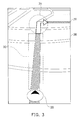
- FIG. 3 is an example of navigation route simulation according to an example of the present application.
- the navigation map 300 displays a navigation route 310 and displays a navigation icon 320 on the navigation route 310 for representing a current location of the simulation.
- the application further classifies the navigation route 310 into a straight path 312 and a turning point 314.
- the navigation apparatus moves the navigation icon 320 in a relatively high speed; and when the navigation icon 320 is moved on the turning point 314, the navigation apparatus moves the navigation icon 320 in a relatively low speed.
- the navigation apparatus displays the electronic map in the form of the three-dimensional bird eye view
- the navigation icon is, for example, displayed in a form of floating above of the navigation route.
- the navigation apparatus not only adjusts the moving speed of the navigation icon to the second speed, but also adjusts a tilting angle of the electronic map, so as to simulate the navigation route through looking down from above.
- the navigation apparatus tilts the displayed electronic map to the right by a tilting angle; on the contrary, when the navigation icon is moved on a right-turning point, the navigation apparatus tilts the displayed electronic map to the left by a tilting angle.
- FIGs. 4(a) to 4(c) illustrate an example of navigation route simulation according to an example of the present application.
- the navigation map 400 is displayed in a form of a three-dimensional bird eye view, which comprises displaying a navigation route 410 and displaying a navigation icon 420 in a form of floating above of the navigation route 410.
- the navigation apparatus moves the navigation icon 420 in a relatively high speed; when the navigation icon 420 is moved on the left-turning point 414, the navigation apparatus not only moves the navigation icon 420 in a relatively low speed, but also tilts the navigation map 400 to the right by a tilting angle; similarly, when the navigation icon 420 is moved on the right-turning point 416, the navigation apparatus not only moves the navigation icon 420 in a relatively low speed, but also tilts the navigation map 400 to the left by a tilting angle.
- the navigation icon may also be displayed in the form of floating above the navigation route, so as to present the same effect as displaying in the form of three-dimensional bird eye view.
- the application further marks a jammed section on the navigation route and automatically reduces the moving speed of the navigation icon when the route simulation is forward to the jammed section, so as to remind the user of paying attention.
- a jammed section on the navigation route and automatically reduces the moving speed of the navigation icon when the route simulation is forward to the jammed section, so as to remind the user of paying attention.
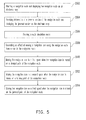
- FIG. 5 is a flowchart showing a method for simulating a navigation route according to an example of the present application.
- the method of the example is suitable for the navigation apparatus 100 in FIG. 1 and detailed steps of the navigation route simulating method of the application are described in detail below with reference to the aforesaid elements of the navigation apparatus 100.
- the navigation apparatus 100 plans a navigation route and displays the navigation route on an electronic map by the processing unit 140 (step S502).
- the processing unit 140 for example, only displays a portion of the navigation route nearby a certain spot on the display unit 120 according to a display scale of the electronic map.
- the navigation apparatus 100 further receives information of a jammed section of the navigation route by a communication unit (not shown) and then displays the jammed section on the electronic map (step S504) after the navigation route is planned.
- the jammed section is, for example, marked by a preset road color or a road pattern on the navigation route, so as to provide the user to catch the actual road condition.
- the communication unit is, for example, a device using a GSM, PHS, CDMA, Wi-Fi, or WiMAX system for communication, which is not limited herein.
- the processing unit 140 determines to enter a route simulation mode according to the operation of the user received by the input unit 130 (step S506). After the route simulation mode is entered, the processing unit 140 starts to generate an effect of moving a navigation icon along the navigation route from a spot of the navigation route (step S508).
- step S510 when the navigation icon is moved on a straight path of the navigation route, the processing unit 140 moves the navigation icon in a first speed (step S510); and when the navigation icon is moved on a turning point of the navigation route, the processing unit 140 moves the navigation icon in a second speed (step S512), in which the second speed is less than the first speed.
- step S512 the second speed is less than the first speed.
- the processing unit 140 moves the navigation icon in a third speed (step S514), in which the third speed is less than the first speed.
- the third speed may be a fixed value, which may be identical to the second speed and may be used to remind the user of noticing the road condition.
- the third speed may also be a variable value, which may be directly proportional to an average vehicle speed of the jammed section. That is to say, the slower the speed of traffic is, the slower the third speed of moving the navigation icon is; and the faster the speed of traffic is, the faster the third speed of moving the navigation icon is.
- FIG. 6 is an example of navigation route simulation according to an example of the present application.
- the navigation apparatus 600 displays a navigation route 610 and displays a navigation icon 620 on the navigation route 610 for representing a current location of the simulation.
- the application further classifies the navigation route 610 into straight paths 612a and 612b, a turning point 614, and a jammed section 616.
- the jammed section 616 is presented, for example, by the weight of the color, in which a deeper color represents a slower speed and a slighter color represents a faster speed.
- the navigation apparatus moves the navigation icon 620 in a relatively low speed.
- the navigation apparatus may represent the condition of the user moving on the navigation route in a most intuitive way.
- the navigation apparatus may emphasize relative information in simulation according to any possible needs of the user in driving on each type of paths, so as to help the user to catch the actual road condition when driving on the navigation route.
- the application further comprises displaying a thumbnail of the navigation route on the map as a reference for the user.
- the thumbnail may be used as a tool for the user to switch between the route simulation mode and the normal display mode. Another example is given below for further illustration.
- FIG. 7 is a flowchart showing a method for simulating a navigation route according to an example of the present application.
- the method of the example is suitable for the navigation apparatus 100 in FIG. 1 and detailed steps of the navigation route simulating method of the application are described in detail below with reference to the aforesaid elements of the navigation apparatus 100.
- the navigation apparatus 100 plans a navigation route and displays the navigation route on an electronic map by using the processing unit 140 (step S702).
- the processing unit 140 for example, only displays a portion of the navigation route nearby a certain spot on the display unit 120 according to a display scale of the electronic map.
- the processing unit 140 further displays a thumbnail of the navigation route on the display unit 120 (step S704), in which the thumbnail comprises, for example, a start point, an end point, a path of the navigation route, and a mark indicating a current location of the navigation apparatus 100.
- the navigation apparatus 100 receives an operation of a user for the thumbnail by using the input unit 130 (step S706), and accordingly activates a route simulation mode to display and move a navigation icon on the navigation route (step S708), so as to simulate the navigation route.
- the processing unit 140 After the route simulation mode is entered, the processing unit 140 starts to generate an effect of moving a navigation icon along the navigation route from a spot of the navigation route (step S710).
- the processing unit 140 moves the navigation icon in a first speed (step S712); and when the navigation icon is moved on a turning point of the navigation route, the processing unit 140 moves the navigation icon in a second speed (step S714), in which the second speed is less than the first speed.
- the navigation apparatus 100 still keeps detecting an operation of a user for the display unit 120 or for the thumbnail displayed on the display unit 120 by using the input unit 130 (step S716).
- the processing unit 140 closes the route simulation mode and resumes the originally displayed navigation route (step S720).
- the processing unit 140 further determines whether the navigation icon arrived at an end point of the navigation route (step S718). If the navigation icon has not arrived at the end point, then the process returns to step S710 to continue moving the navigation icon. However, if the input unit 130 does not receive the operation of the user in the simulation of the navigation route, then when the navigation icon arrived at the end point of the navigation route, the processing unit 140 closes the route simulation mode and resumes the originally displayed navigation route (step S720).
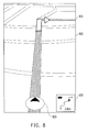
- FIG. 8 is an example of navigation route simulation according to an example of the present application.
- the navigation map 800 displays a navigation route 810 and displays a navigation icon 820 on the navigation route 810 for representing a current location of the simulation.
- a thumbnail 830 of the navigation route 810 is further displayed on a lower right corner of the navigation map 800, in which the thumbnail 830 is drawn in simple lines and marked with a start point and an end point of the navigation route, and a location of the navigation on the navigation route, so as to be provide for the user to reference.
- the thumbnail 830 itself may also be a touchable screen button, such that the user only needs to touch the thumbnail 830, then the navigation apparatus activates or closes the route simulation mode correspondingly.
- the navigation apparatus may provide a simple way for the user to switch between the route simulation mode and the normal display mode without affecting the user viewing the navigation route.
- the present application further provides a computer program product which records a computer program to be loaded into a mobile device to execute the method for simulating the navigation route as described above.
- the computer program is composed of a plurality of program instructions (for example, an organization chart establishing program instruction, a table approving program instruction, a setting program instruction, and a deployment program instruction, etc), and these program instructions are loaded into the mobile device and executed by the same to accomplish various steps in the method for simulating the navigation route and various functions of the navigation apparatus described above.
- the method for simulating the navigation route, the navigation apparatus, and the computer program product of the application adjust a moving speed of the navigation icon according to the type of the simulated path in the simulation of the navigation route, so as to remind the user of paying attention and to enhance the impression of the user.
- the application also reduces the moving speed of the navigation icon when the simulation is proceeded to a jammed section, so as to remind the user of paying attention to the road condition.
- a method for simulating a navigation route, a navigation apparatus, and a recording medium are provided.
- a navigation route is planned and displayed on an electronic map.
- an effect of a navigation icon moving along the navigation route starting from a certain spot in the navigation route is generated.
- the navigation icon is moved in a first speed.
- the navigation icon is moved in a second speed, in which the second speed is smaller than the first speed.
Abstract
Description
- The conventional navigation apparatus has a built-in smart electronic map and can execute functions of route planning and navigation. The user is only required to input a name or a coordinate of a destination to be leave for, or directly select a particular location on the electronic map, and then the navigation apparatus automatically plans a navigation route based on the detected location and a geographical location of the destination input by the user, and delivers a voice message to guide the user to the destination along the planned navigation route.
- When displaying the navigation route, if the distance between the start point and the end point of the navigation route is too long, the map displayed by the navigation apparatus may cover a larger range and is not able to reveal the details of the map. However, when a user activates the navigation function, in order to show the details of the map nearby the area where the user is located, the navigation apparatus adjusts the display scale of the map and navigation route to the area nearby the apparatus, so as to increase the readability of the map.
- Through the aforesaid method for adjusting the display scale of the map, the navigation apparatus can only display a portion of the navigation route when executing the navigation function. However, in the process of navigation, if the user intends to browse the whole navigation route, the user has to adjust the display scale of the map manually. Even if the adjusted map can show the whole navigation route, the user still cannot know the actual road condition, such as where to make a turn or where it is jammed. Therefore, there is a need to provide a navigation route simulation method that can truly reflect the actual road condition, such that the user can activate freely to catch the whole and actual road condition.
- The application is directed to a method for simulating navigation route, which adjusts a moving speed of the navigation icon according to the type or the state of the path, so as to simulate the actual road condition.
- The application is also directed to a navigation apparatus, in which the moving speed of a navigation icon is reduced when encountering a turning point or a jammed section, so as to remind the user of paying attention.
- The application provides a method for simulating a navigation route, suitable for a mobile device having a screen. In the method, a navigation route is planned and displayed on an electronic map. When a route simulation mode is entered, an effect of moving a navigation icon along the navigation route from a spot of the navigation route is generated. When the navigation icon is moved on a straight path of the navigation route, the navigation icon is moved in a first speed; and when the navigation icon is moved on a turning point of the navigation route, the navigation icon is moved in a second speed, in which the second speed is less than the first speed.
- In one example of the application, the step of displaying the navigation route on the electronic map comprises only displaying a portion of the navigation route nearby the spot according to a display scale of the electronic map.
- In one example of the application, the step of displaying the navigation route on the electronic map further comprises displaying a thumbnail of the navigation route on the electronic map, in which the thumbnail comprises a start point, an end point and a path of the navigation route, and comprises a mark indicating a current location of the navigation icon.
- In one example of the application, the step of entering the route simulation mode comprises receiving an operation of a user for the thumbnail and activating the route simulation mode accordingly, so as to display and move the navigation icon.
- In one example of the application, the step of generating the effect of moving the navigation icon along the navigation route from the spot of the navigation route further comprises receiving an operation of a user for the screen and closing the route simulation mode accordingly, so as to resume the originally displayed navigation route.
- In one example of the application, the step of receiving the operation of the user for the screen comprises receiving the operation of the user for the thumbnail displayed on the screen.
- In one example of the application, after the step of generating the effect of moving the navigation icon along the navigation route from the spot of the navigation route, the method further comprises closing the route simulation mode to resume the originally displayed navigation route when the navigation icon arrives at an end point of the navigation route.
- In one example of the application, the step of generating the effect of moving the navigation icon along the navigation route from the spot of the navigation route comprises panning the electronic map and keeping a location of the navigation icon on the screen unchanged according to the navigation route, so as to generate the effect of moving the navigation icon along the navigation route.
- In one example of the application, the method further receives information of a jammed section on the navigation route and displays the same on the electronic map, in which the step of generating the effect of moving the navigation icon along the navigation route further comprises moving the navigation icon in a third speed when the navigation icon is moved on the jammed section of the navigation route, wherein the third speed is less than the first speed.
- In one example of the application, the step of displaying the navigation route on the electronic map comprises displaying the electronic map in a form of a three-dimensional bird eye view or a two-dimensional plan, and displaying the navigation route on the electronic map.
- In one example of the application, the navigation icon is displayed in a form of floating above of the navigation route.
- In one example of the application, the step of generating the effect of moving the navigation icon in the second speed when the navigation icon is moved on the turning point of the navigation route further comprises tilting the electronic map to the right by a tilting angle when the navigation icon is moved on a left-turning point of the navigation route and tilting the electronic map to the left by the tilting angle when the navigation icon is moved on a right-turning point of the navigation route.
- In one example of the application, the spot where the route simulation mode starts is the start point of the navigation route or a current location of the mobile device.
- The application provides a navigation apparatus comprising a display unit, an input unit, and a processing unit. The display unit is used to display an electronic map. The input unit is used to receive an operation of a user. The processing unit is coupled to the display unit and the input unit, and is used for planning a navigation route, displaying the navigation route on the electronic map, and entering a route simulation mode to generate an effect of moving a navigation icon along the navigation route from a spot of the navigation route when the input unit receives the operation. When the navigation icon is moved on a straight path of the navigation route, the navigation icon is moved in a first speed; and when the navigation icon is moved on a turning point of the navigation route, the navigation icon is moved in a second speed, in which the second speed is less than the first speed.
- The present application further provides a computer program product which comprises instructions to be loaded into a mobile device to execute following steps. A navigation route is planned and displayed on an electronic map. When a route simulation mode is entered, an effect of moving a navigation icon along the navigation route from a spot of the navigation route is generated. When the navigation icon is moved on a straight path of the navigation route, the navigation icon is moved in a first speed; and when the navigation icon is moved on a turning point of the navigation route, the navigation icon is moved in a second speed, in which the second speed is less than the first speed.
- Based on the above, the method for simulating the navigation route, the navigation apparatus, and the computer program product of the application simulate the navigation route by moving a navigation icon, in which the navigation icon is moved in a faster speed when moving on a straight path and moved in a slower speed when moving on a turning point or a jammed section, such that the simulation of the navigation route may reveal actual road condition.
- In order to make the aforementioned and other features and advantages of the application more comprehensible, examples accompanying figures are described in detail below.
- The accompanying drawings are included to provide a further understanding of the application, and are incorporated in and constitute a part of this specification. The drawings illustrate examples of the application and, together with the description, serve to explain the principles of the application.
-
Fig. 1 is a block diagram of a navigation apparatus according to an example of the present application. -
FIG. 2 is a flowchart showing a method for simulating a navigation route according to an example of the present application. -
FIG. 3 is an example of navigation route simulation according to an example of the present application. -
FIG. 4 is an example of navigation route simulation according to an example of the present application. -
FIG. 5 is a flowchart showing a method for simulating a navigation route according to an example of the present application. -
FIG. 6 is an example of navigation route simulation according to an example of the present application. -
FIG. 7 is a flowchart showing a method for simulating a navigation route according to an example of the present application. -
FIG. 8 is an example of navigation route simulation according to an example of the present application. - The application provides users with ease to freely activate a simulation for the navigation route in the process of the navigation apparatus executing the navigation function. When simulating the navigation route, the application adaptively adjusts a moving speed of the navigation icon according to the type or the state of the path passed by the navigation icon, so as to remind the user of paying attention and to enhance the impression of the user.
-
Fig. 1 is a block diagram of a navigation apparatus according to an example of the present application. Referring toFIG. 1 , thenavigation apparatus 100 comprises apositioning unit 110, adisplay unit 120, aninput unit 130, and aprocessing unit 140, and is able to provide simulation function of the navigation route and provide users with ease to preview the navigation route. Thenavigation apparatus 100 is, for example, a mobile phone, a smartphone, a personal digital assistant (PDA), a PDA phone, a car PC, a notebook, a multimedia player, or a handheld gamer. The functions of aforesaid elements are respectively described as follows. - The
positioning unit 110 is used for obtaining a current location of thenavigation apparatus 100, and is, for example, a global positioning system (GPS), or other positioning systems using a global system for mobile communication (GSM) system, a personal handy-phone system (PHS), a code division multiple access (CDMA) system, a wireless fidelity (Wi-Fi) system, a worldwide interoperability for microwave access (WiMAX) system, a radio repeater, or a radio broadcaster for performing positioning, which is not limited by the present example. - The
display unit 120 is, for example, a liquid crystal display (LCD), a light emitting diode (LED) display, an organic light emitting diode (OLED) display, a field emission display (FED), and/or other displays suitable for displaying the navigation frame. - The
input unit 130 is, for example, a mouse, a keyboard, a joystick, or a touch pad, and is used for receiving an operation of a user for planning a navigation route. Theinput unit 130 is, for example, a resistive type, a capacitive type, or other types of touch sensitive units, and is able to be integrated with thedisplay unit 120 to form a touch screen. - The
processing unit 140 is, for example, a central processing unit (CPU), or other programmable ordinarily-used or specifically-used microprocessor, digital signal processor (DSP), programmable controller, application specific integrated circuit (ASIC), programmable logic device (PLD), or other similar devices or a combination of those devices. - The
processing unit 140 is coupled to thepositioning unit 110, thedisplay unit 120 and theinput unit 130, and is able to plan a navigation route according to an operation received by theinput unit 130 and to execute a simulation function of the navigation route. Examples are given below for illustrating detailed steps of thenavigation apparatus 100 simulating the navigation route. -
FIG. 2 is a flowchart showing a method for simulating a navigation route according to an example of the present application. Referring toFIG. 2 , the method of the example is suitable for thenavigation apparatus 100 inFIG. 1 , and detailed steps of the navigation route simulating method of the application are described in detail below with reference to the aforesaid elements of thenavigation apparatus 100. - First, the
navigation apparatus 100 plans a navigation route and displays the navigation route on an electronic map by the processing unit 140 (step S202). Thenavigation apparatus 100, for example, displays the electronic map in a form of a two-dimensional plan or a three-dimensional bird eye view, and marks the navigation route on the electronic map. - In detail, the
navigation apparatus 100 detects a current location thereof by using thepositioning unit 110, receives a start point and an end point by using theinput unit 130, and plans the navigation route by using theprocessing unit 140 according to the start point and the end point received by theinput unit 130. The location of the start point received by theinput unit 130 is, for example, the current location of thenavigation apparatus 100 detected by thepositioning unit 110, a coordinate entered by the user or a location of a point of interest (POI) selected from a POI list by the user. The location of the end point is, for example, a coordinate entered by the user or a location of a POI selected from a POI list by the user, which is not limited herein. - It should be noted herein that in the condition that the start point of the navigation route is far away from the end point of the navigation route, the
navigation apparatus 100 has to limit the display range of the map, so as to reveal the details of the map. When displaying the navigation route, thenavigation apparatus 100 may only display the navigation route nearby the current location (e.g. the location of the navigation apparatus 100). - Next, the
processing unit 140 enters a route simulation mode (step S204). Theprocessing unit 140, for example, activates the route simulation mode after theinput unit 130 receives the operation of the user, in which the operation may be a pressing operation of the user performed on a physical button on theinput unit 130, or a touch operation of the user performed on theinput unit 130 corresponding to a virtual button or icon displayed by thedisplay unit 120, which is not limited herein. - After the route simulation mode is entered, the
processing unit 140 starts to generate an effect of moving a navigation icon along the navigation route from a spot of the navigation route (step S206). The spot where aforesaid route simulation starts is, for example, the start point of the navigation route, or a current location of thenavigation apparatus 100 detected by thepositioning unit 110. Further, when generating the effect of moving the navigation icon on the electronic map, theprocessing unit 140, for example, fixes the navigation icon on a particular location of the frame displayed by the display unit 120 (e.g. center of the lower part of the frame), and pans the electronic map according the moving direction of the navigation route, so as to generate the effect of moving the navigation icon along the navigation route. In brief, in the frame displayed by thedisplay unit 120, the navigation icon is not moved while the electronic map is moved instead, such that a visional effect presented thereby is the navigation icon moving on the electronic map. - In the simulation of the navigation route, when the navigation icon is moved on a straight path of the navigation route, the
processing unit 140 moves the navigation icon in a first speed (step S208); and when the navigation icon is moved on a turning point of the navigation route, theprocessing unit 140 moves the navigation icon in a second speed (step S210), in which the second speed is less than the first speed. - In detail, according to the habit of a driver, usually the driver does not pay attention to nearby road condition (or environment) when driving in a straight path and only pays attention to the nearby road condition when making a turn and meanwhile tries to find a specific target, generally a building, or a guideboard of a road, so as to make the turn. Accordingly, the application takes use of a faster speed to move the navigation icon when the simulation proceeded to the straight path, so as to increase the speed of the simulation. On the other hand, the application takes use of a slower speed to move the navigation icon when the simulation is proceeded to the turning point, so as to remind the user of paying attention and to enhance the impression of the user.
- For instance,
FIG. 3 is an example of navigation route simulation according to an example of the present application. Referring toFIG. 3 , thenavigation map 300 displays anavigation route 310 and displays anavigation icon 320 on thenavigation route 310 for representing a current location of the simulation. The application further classifies thenavigation route 310 into astraight path 312 and aturning point 314. When thenavigation icon 320 is moved on thestraight path 312, the navigation apparatus moves thenavigation icon 320 in a relatively high speed; and when thenavigation icon 320 is moved on theturning point 314, the navigation apparatus moves thenavigation icon 320 in a relatively low speed. - It should be noted herein that when the navigation apparatus displays the electronic map in the form of the three-dimensional bird eye view, the navigation icon is, for example, displayed in a form of floating above of the navigation route. Further, when the navigation icon is moved on the turning point of the navigation route, the navigation apparatus not only adjusts the moving speed of the navigation icon to the second speed, but also adjusts a tilting angle of the electronic map, so as to simulate the navigation route through looking down from above. In detail, when the navigation icon is moved on a left-turning point, the navigation apparatus tilts the displayed electronic map to the right by a tilting angle; on the contrary, when the navigation icon is moved on a right-turning point, the navigation apparatus tilts the displayed electronic map to the left by a tilting angle.
- For example,
FIGs. 4(a) to 4(c) illustrate an example of navigation route simulation according to an example of the present application. Referring toFIG. 4(a) , thenavigation map 400 is displayed in a form of a three-dimensional bird eye view, which comprises displaying anavigation route 410 and displaying anavigation icon 420 in a form of floating above of thenavigation route 410. When thenavigation icon 420 is moved on thestraight path 412, the navigation apparatus moves thenavigation icon 420 in a relatively high speed; when thenavigation icon 420 is moved on the left-turning point 414, the navigation apparatus not only moves thenavigation icon 420 in a relatively low speed, but also tilts thenavigation map 400 to the right by a tilting angle; similarly, when thenavigation icon 420 is moved on the right-turning point 416, the navigation apparatus not only moves thenavigation icon 420 in a relatively low speed, but also tilts thenavigation map 400 to the left by a tilting angle. - Similarly, when the navigation apparatus displays the electronic map in the form of two-dimensional plan, the navigation icon may also be displayed in the form of floating above the navigation route, so as to present the same effect as displaying in the form of three-dimensional bird eye view.
- In another example, regarding the actual condition of a traffic jam, the application further marks a jammed section on the navigation route and automatically reduces the moving speed of the navigation icon when the route simulation is forward to the jammed section, so as to remind the user of paying attention. Another example is given below for further illustration.
-
FIG. 5 is a flowchart showing a method for simulating a navigation route according to an example of the present application. Referring toFIG. 5 , the method of the example is suitable for thenavigation apparatus 100 inFIG. 1 and detailed steps of the navigation route simulating method of the application are described in detail below with reference to the aforesaid elements of thenavigation apparatus 100. - First, the
navigation apparatus 100 plans a navigation route and displays the navigation route on an electronic map by the processing unit 140 (step S502). Theprocessing unit 140, for example, only displays a portion of the navigation route nearby a certain spot on thedisplay unit 120 according to a display scale of the electronic map. - The difference from the aforesaid example is that, in the present example, the
navigation apparatus 100 further receives information of a jammed section of the navigation route by a communication unit (not shown) and then displays the jammed section on the electronic map (step S504) after the navigation route is planned. The jammed section is, for example, marked by a preset road color or a road pattern on the navigation route, so as to provide the user to catch the actual road condition. The communication unit is, for example, a device using a GSM, PHS, CDMA, Wi-Fi, or WiMAX system for communication, which is not limited herein. - Next, the
processing unit 140 determines to enter a route simulation mode according to the operation of the user received by the input unit 130 (step S506). After the route simulation mode is entered, theprocessing unit 140 starts to generate an effect of moving a navigation icon along the navigation route from a spot of the navigation route (step S508). - In the simulation of the navigation route, when the navigation icon is moved on a straight path of the navigation route, the
processing unit 140 moves the navigation icon in a first speed (step S510); and when the navigation icon is moved on a turning point of the navigation route, theprocessing unit 140 moves the navigation icon in a second speed (step S512), in which the second speed is less than the first speed. The detailed content of the above steps S506-S512 are all identical or similar to the steps S204-S210 in the above example, and will not be described herein. - It should be noted herein that, in the present example, when the navigation icon is moved on the jammed section of the navigation route, the
processing unit 140 moves the navigation icon in a third speed (step S514), in which the third speed is less than the first speed. In detail, the third speed may be a fixed value, which may be identical to the second speed and may be used to remind the user of noticing the road condition. In addition, the third speed may also be a variable value, which may be directly proportional to an average vehicle speed of the jammed section. That is to say, the slower the speed of traffic is, the slower the third speed of moving the navigation icon is; and the faster the speed of traffic is, the faster the third speed of moving the navigation icon is. - For example,
FIG. 6 is an example of navigation route simulation according to an example of the present application. Referring toFIG. 6 , thenavigation apparatus 600 displays anavigation route 610 and displays anavigation icon 620 on thenavigation route 610 for representing a current location of the simulation. The application further classifies thenavigation route 610 intostraight paths turning point 614, and ajammed section 616. The jammedsection 616 is presented, for example, by the weight of the color, in which a deeper color represents a slower speed and a slighter color represents a faster speed. When thenavigation icon 620 is moved on the jammedsection 616, the navigation apparatus moves thenavigation icon 620 in a relatively low speed. - Through aforesaid navigation route simulating method, the navigation apparatus may represent the condition of the user moving on the navigation route in a most intuitive way. The navigation apparatus may emphasize relative information in simulation according to any possible needs of the user in driving on each type of paths, so as to help the user to catch the actual road condition when driving on the navigation route.
- In another example, regarding the condition that the start point of the navigation route is far away from the end point of the navigation route, to provide the user with ease to check a corresponding relation between the current location and the location of the end point in the navigation process, the application further comprises displaying a thumbnail of the navigation route on the map as a reference for the user. The thumbnail may be used as a tool for the user to switch between the route simulation mode and the normal display mode. Another example is given below for further illustration.
-
FIG. 7 is a flowchart showing a method for simulating a navigation route according to an example of the present application. Referring toFIG. 7 , the method of the example is suitable for thenavigation apparatus 100 inFIG. 1 and detailed steps of the navigation route simulating method of the application are described in detail below with reference to the aforesaid elements of thenavigation apparatus 100. - First, the
navigation apparatus 100 plans a navigation route and displays the navigation route on an electronic map by using the processing unit 140 (step S702). Theprocessing unit 140, for example, only displays a portion of the navigation route nearby a certain spot on thedisplay unit 120 according to a display scale of the electronic map. In addition, theprocessing unit 140 further displays a thumbnail of the navigation route on the display unit 120 (step S704), in which the thumbnail comprises, for example, a start point, an end point, a path of the navigation route, and a mark indicating a current location of thenavigation apparatus 100. - Next, the
navigation apparatus 100 receives an operation of a user for the thumbnail by using the input unit 130 (step S706), and accordingly activates a route simulation mode to display and move a navigation icon on the navigation route (step S708), so as to simulate the navigation route. - After the route simulation mode is entered, the
processing unit 140 starts to generate an effect of moving a navigation icon along the navigation route from a spot of the navigation route (step S710). When the navigation icon is moved on a straight path of the navigation route, theprocessing unit 140 moves the navigation icon in a first speed (step S712); and when the navigation icon is moved on a turning point of the navigation route, theprocessing unit 140 moves the navigation icon in a second speed (step S714), in which the second speed is less than the first speed. - It should be noted herein that, in the simulation of the navigation route, the
navigation apparatus 100 still keeps detecting an operation of a user for thedisplay unit 120 or for the thumbnail displayed on thedisplay unit 120 by using the input unit 130 (step S716). When theinput unit 130 receives the operation of the user, theprocessing unit 140 closes the route simulation mode and resumes the originally displayed navigation route (step S720). - On the other hand, if the
input unit 130 does not receive the operation of the user, theprocessing unit 140 further determines whether the navigation icon arrived at an end point of the navigation route (step S718). If the navigation icon has not arrived at the end point, then the process returns to step S710 to continue moving the navigation icon. However, if theinput unit 130 does not receive the operation of the user in the simulation of the navigation route, then when the navigation icon arrived at the end point of the navigation route, theprocessing unit 140 closes the route simulation mode and resumes the originally displayed navigation route (step S720). - For example,
FIG. 8 is an example of navigation route simulation according to an example of the present application. Referring toFIG. 8 , thenavigation map 800 displays anavigation route 810 and displays anavigation icon 820 on thenavigation route 810 for representing a current location of the simulation. In addition, athumbnail 830 of thenavigation route 810 is further displayed on a lower right corner of thenavigation map 800, in which thethumbnail 830 is drawn in simple lines and marked with a start point and an end point of the navigation route, and a location of the navigation on the navigation route, so as to be provide for the user to reference. Thethumbnail 830 itself may also be a touchable screen button, such that the user only needs to touch thethumbnail 830, then the navigation apparatus activates or closes the route simulation mode correspondingly. - Through aforesaid navigation route simulation method, the navigation apparatus may provide a simple way for the user to switch between the route simulation mode and the normal display mode without affecting the user viewing the navigation route.
- The present application further provides a computer program product which records a computer program to be loaded into a mobile device to execute the method for simulating the navigation route as described above. The computer program is composed of a plurality of program instructions (for example, an organization chart establishing program instruction, a table approving program instruction, a setting program instruction, and a deployment program instruction, etc), and these program instructions are loaded into the mobile device and executed by the same to accomplish various steps in the method for simulating the navigation route and various functions of the navigation apparatus described above.
- In summary, the method for simulating the navigation route, the navigation apparatus, and the computer program product of the application adjust a moving speed of the navigation icon according to the type of the simulated path in the simulation of the navigation route, so as to remind the user of paying attention and to enhance the impression of the user. In addition, the application also reduces the moving speed of the navigation icon when the simulation is proceeded to a jammed section, so as to remind the user of paying attention to the road condition.
In conclusion a method for simulating a navigation route, a navigation apparatus, and a recording medium are provided. In the method, a navigation route is planned and displayed on an electronic map. When a route simulation mode is entered, an effect of a navigation icon moving along the navigation route starting from a certain spot in the navigation route is generated. When moving on a straight path of the navigation route, the navigation icon is moved in a first speed. When moving on a turning point of the navigation route, the navigation icon is moved in a second speed, in which the second speed is smaller than the first speed. - Although the application has been described with reference to the above examples, it will be apparent to one of the ordinary skill in the art that modifications to the described example may be made without departing from the spirit of the application. Accordingly, the scope of the application will be defined by the attached claims not by the above detailed descriptions.
Claims (15)
- A method for simulating a navigation route, suitable for a mobile device having a screen, the method comprising:planning (S202) a navigation route (310, 410, 610, 810) and displaying the navigation route (310, 410, 610, 810) on an electronic map (300, 400, 600, 800);entering (S204) a route simulation mode;generating (S206) an effect of moving a navigation icon (320, 420, 620, 820) along the navigation route (310, 410, 610, 810) from a spot in the navigation route (310, 410, 610, 810);moving (S208) the navigation icon (320, 420, 620, 820) in a first speed when the navigation icon (320, 420, 620, 820) is moved on a straight path (312, 412, 612a, 612b) of the navigation route (310, 410, 610, 810); andmoving (S210) the navigation icon (320, 420, 620, 820) in a second speed when the navigation icon (320, 420, 620, 820) is moved on a turning point (314, 614) of the navigation route (310, 410, 610, 810), wherein the second speed is less than the first speed.
- The method of claim 1, wherein the step of displaying the navigation route (310, 410, 610, 810) on the electronic map (300, 400, 600, 800) further comprises:displaying (S704) a thumbnail (830) of the navigation route (310, 410, 610, 810) on the electronic map (300, 400, 600, 800).
- The method of claim 1 or 2, wherein the step of generating the effect of moving the navigation icon (320, 420, 620, 820) along the navigation route (310, 410, 610, 810) from the spot of the navigation route (310, 410, 610, 810) comprises:according to the navigation route (310, 410, 610, 810), panning the electronic map (300, 400, 600, 800) while keeping a location of the navigation icon (320, 420, 620, 820) on the screen unchanged, to generate the effect of moving the navigation icon (320, 420, 620, 820) along the navigation route (310, 410, 610, 810).
- The method of any one of claims 1 to 3, further comprising:receiving (S502) information of a jammed section (616) of the navigation route (310, 410, 610, 810) and displaying the jammed section (616) on the electronic map (300, 400, 600, 800); andmoving (S514) the navigation icon (320, 420, 620, 820) in a third speed when the navigation icon (320, 420, 620, 820) is moved on the jammed section (616) of the navigation route (310, 410, 610, 810), wherein the third speed is less than the first speed.
- The method of any one of claims 1 to 4, wherein the step of displaying the navigation route (310, 410, 610, 810) on the electronic map (300, 400, 600, 800) comprises:displaying the electronic map (300, 400, 600, 800) in a form of a three-dimensional bird eye view or a two-dimensional plan, and displaying the navigation route (310, 410, 610, 810) on the electronic map (300, 400, 600, 800).
- The method of any one of claims 1 to 4, wherein the navigation icon (320, 420, 620, 820) is displayed in a form of floating above the navigation route (310, 410, 610, 810), and the step of moving the navigation icon (320, 420, 620, 820) in the second speed when the navigation icon (320, 420, 620, 820) is moved on the turning point (314, 614) of the navigation route (310, 410, 610, 810) further comprises:tilting the electronic map (300, 400, 600, 800) to the right by a tilting angle when the navigation icon (320, 420, 620, 820) is moved on a left-turning point (414) of the navigation route (310, 410, 610, 810); andtilting the electronic map (300, 400, 600, 800) to the left by the tilting angle when the navigation icon (320, 420, 620, 820) is moved on a right-turning point (416) of the navigation route (310, 410, 610, 810).
- A computer program product, comprising instructions for being loaded into a mobile device to enable the mobile device to execute the method for operating a navigation apparatus of any one of claims 1 to 6.
- A navigation apparatus, comprising:a display unit (120), for displaying an electronic map (300, 400, 600, 800);an input unit (130), for receiving an operation of a user; anda processing unit (140), coupled to the display unit (120) and the input unit (130), for planning a navigation route (310, 410, 610, 810), displaying the navigation route (310, 410, 610, 810) on the electronic map (300, 400, 600, 800), and entering a route simulation mode to generate an effect of moving a navigation icon (320, 420, 620, 820) along the navigation route (310, 410, 610, 810) from a spot of the navigation route (310, 410, 610, 810) when the input unit (130) receives the operation, whereinwhen the navigation icon (320, 420, 620, 820) is moved on a straight path (312, 412, 612a, 612b) of the navigation route (310, 410, 610, 810), the navigation icon (320, 420, 620, 820) is moved in a first speed; andwhen the navigation icon (320, 420, 620, 820) is moved on a turning point (314, 614) of the navigation route (310, 410, 610, 810), the navigation icon (320, 420, 620, 820) is moved in a second speed, wherein the second speed is less than the first speed.
- The navigation apparatus of claim 8, wherein the processing unit (140) further comprises displaying a thumbnail (830) of the navigation route (310, 410, 610, 810) on the electronic map (300, 400, 600, 800), and wherein when the input unit (130) receives an operation of a user for the thumbnail (830), the processing unit (140) activates the route simulation mode to display and move the navigation icon (320, 420, 620, 820), and in the process of the processing unit (140) moving the navigation icon (320, 420, 620, 820) along the navigation route (310, 410, 610, 810), when the input unit (130) receives the operation of the user for the thumbnail (830) displayed on the display unit (120), the processing unit (140) closes the route simulation mode to resume the originally displayed navigation route (310, 410, 610, 810).
- The navigation apparatus of claim 8 or 9, wherein when the navigation icon (320, 420, 620, 820) arrives at an end point of the navigation route (310, 410, 610, 810), the processing unit (140) further comprises closing the route simulation mode to resume the originally displayed navigation route (310, 410, 610, 810).
- The navigation apparatus of any one of claims 8 to 10, wherein the processing unit (140) comprises panning the electronic map (300, 400, 600, 800) while keeping a location of the navigation icon (320, 420, 620, 820) on the screen unchanged according to the navigation route (310, 410, 610, 810), to generate the effect of moving the navigation icon (320, 420, 620, 820) along the navigation route (310, 410, 610, 810).
- The navigation apparatus of any one of claims 8 to 11, further comprising:a communication unit, for receiving information of a jammed section (616) of the navigation route (310, 410, 610, 810), which is then displayed on the electronic map (300, 400, 600, 800) by the processing unit (140), whereinthe processing unit (140) further comprises moving the navigation icon (320, 420, 620, 820) in a third speed when the navigation icon (320, 420, 620, 820) is moved on the jammed section (616) of the navigation route (310, 410, 610, 810), wherein the third speed is less than the first speed.
- The navigation apparatus of any one of claims 9 to 12, wherein the processing unit (140) comprises displaying the electronic map (300, 400, 600, 800) in a form of a three-dimensional bird eye view or a two-dimensional plan, and displaying the navigation route (310, 410, 610, 810) on the electronic map (300, 400, 600, 800).
- The navigation apparatus of any one of claims 9 to 12, wherein the processing unit (140) comprises displaying the navigation icon (320, 420, 620, 820) in a form of floating above of the navigation route (310, 410, 610, 810), and further comprises tilting the electronic map (300, 400, 600, 800) to the right by a tilting angle when the navigation icon (320, 420, 620, 820) is moved on a left-turning point (414) of the navigation route (310, 410, 610, 810) and tilting the electronic map (300, 400, 600, 800) to the left by the tilting angle when the navigation icon (320, 420, 620, 820) is moved on a right-turning point (416) of the navigation route (310, 410, 610, 810).
- A navigation route simulation system, comprising:a display means for displaying an electronic map (300, 400, 600, 800);an input means for receiving an operation of a user;a route planning means for planning a navigation route (310, 410, 610, 810) and displaying the navigation route (310, 410, 610, 810) on the electronic map (300, 400, 600, 800); anda route simulation means for entering a route simulation mode to generate an effect of moving a navigation icon (320, 420, 620, 820) along the navigation route (310, 410, 610, 810) from a spot of the navigation route (310, 410, 610, 810) when the input receives the operation, whereinwhen the navigation icon (320, 420, 620, 820) is moved on a straight path (312, 412, 612a, 612b) of the navigation route (310, 410, 610, 810), the navigation icon (320, 420, 620, 820) is moved in a first speed; andwhen the navigation icon (320, 420, 620, 820) is moved on a turning point (314, 614) of the navigation route (310, 410, 610, 810), the navigation icon (320, 420, 620, 820) is moved in a second speed, wherein the second speed is less than the first speed.
Applications Claiming Priority (2)
| Application Number | Priority Date | Filing Date | Title |
|---|---|---|---|
| US22895709P | 2009-07-27 | 2009-07-27 | |
| TW098146406A TWI440828B (en) | 2009-07-27 | 2009-12-31 | Mehtod for simulating navigation route, navigation apparatus and computer program product |
Publications (2)
| Publication Number | Publication Date |
|---|---|
| EP2280244A1 true EP2280244A1 (en) | 2011-02-02 |
| EP2280244B1 EP2280244B1 (en) | 2012-12-19 |
Family
ID=42942093
Family Applications (1)
| Application Number | Title | Priority Date | Filing Date |
|---|---|---|---|
| EP10170963A Not-in-force EP2280244B1 (en) | 2009-07-27 | 2010-07-27 | Method for simulating navigation route, navigation apparatus and computer program product |
Country Status (2)
| Country | Link |
|---|---|
| US (1) | US20110022295A1 (en) |
| EP (1) | EP2280244B1 (en) |
Cited By (1)
| Publication number | Priority date | Publication date | Assignee | Title |
|---|---|---|---|---|
| EP2843368A3 (en) * | 2013-08-30 | 2015-04-29 | BlackBerry Limited | Method and device for computer-based navigation |
Families Citing this family (14)
| Publication number | Priority date | Publication date | Assignee | Title |
|---|---|---|---|---|
| US8902219B1 (en) | 2010-09-22 | 2014-12-02 | Trimble Navigation Limited | Maintaining connection to embedded content using graphical elements |
| US9076244B2 (en) | 2011-06-29 | 2015-07-07 | Trimble Navigation Limited | Managing web page data in a composite document |
| US9411901B2 (en) * | 2011-06-29 | 2016-08-09 | Trimble Navigation Limited | Managing satellite and aerial image data in a composite document |
| GB2492381A (en) * | 2011-06-30 | 2013-01-02 | Tomtom Int Bv | Controlling a map displayed on a navigation apparatus in order to maximise the display of a remaining route |
| TWI450227B (en) | 2012-06-05 | 2014-08-21 | Wistron Corp | Navigation device and navigation method capable of presenting prompt information with different light effects by software |
| US9459115B1 (en) * | 2014-03-28 | 2016-10-04 | Amazon Technologies, Inc. | Unobstructed map navigation using animation |
| JP6379943B2 (en) * | 2014-09-30 | 2018-08-29 | 富士通株式会社 | Moving path integration method, apparatus, and program |
| CN104361766B (en) * | 2014-11-27 | 2016-12-07 | 重庆智韬信息技术中心 | The system of parking navigation is realized based on 3-dimensional digital modeling |
| US10302446B2 (en) * | 2016-06-12 | 2019-05-28 | Apple Inc. | Context driven navigation presentation |
| CN106403978A (en) * | 2016-09-30 | 2017-02-15 | 北京百度网讯科技有限公司 | Navigation route generating method and device |
| CN107610501A (en) * | 2017-08-10 | 2018-01-19 | 浙江科技学院 | Parking garage vehicle guidance method |
| CN108682181A (en) * | 2018-07-12 | 2018-10-19 | 合肥市神雕起重机械有限公司 | Vehicles management method in a kind of intelligent garage Internet-based |
| CN109253736A (en) * | 2018-08-28 | 2019-01-22 | 上海擎感智能科技有限公司 | A kind of air navigation aid, device, electric terminal and medium |
| CN111899551B (en) * | 2020-06-16 | 2021-09-17 | 广州文远知行科技有限公司 | Method, apparatus, computer device and storage medium for determining parking spot |
Citations (7)
| Publication number | Priority date | Publication date | Assignee | Title |
|---|---|---|---|---|
| US5541592A (en) * | 1993-08-09 | 1996-07-30 | Matsushita Electric Industrial Co., Inc. | Positioning system |
| US20010020211A1 (en) * | 2000-02-14 | 2001-09-06 | Kuniharu Takayama | Navigation information presenting apparatus and method thereof |
| US20070225902A1 (en) * | 2004-03-15 | 2007-09-27 | Tomtom International B.V. | Navigation Device Displaying Dynamic Travel Information |
| US20080046178A1 (en) * | 2006-08-17 | 2008-02-21 | Bayerische Motoren Werke Aktiengesellschaft | Vehicle Navigation System |
| JP2008185522A (en) * | 2007-01-31 | 2008-08-14 | Xanavi Informatics Corp | Navigation device and demonstration display method of route guidance |
| DE102008057372A1 (en) * | 2008-11-14 | 2009-07-02 | Daimler Ag | Active destination guidance information displaying method for vehicle i.e. motor vehicle, involves displaying detected and predicted temporal-spatial traffic patterns on ahead-lying driving route in animated preview of route |
| WO2010040389A1 (en) * | 2008-10-07 | 2010-04-15 | Tomtom International B.V. | Route preview |
Family Cites Families (4)
| Publication number | Priority date | Publication date | Assignee | Title |
|---|---|---|---|---|
| JPS4841188A (en) * | 1971-09-29 | 1973-06-16 | ||
| US7634352B2 (en) * | 2003-09-05 | 2009-12-15 | Navteq North America, Llc | Method of displaying traffic flow conditions using a 3D system |
| US7610560B2 (en) * | 2004-11-16 | 2009-10-27 | Microsoft Corporation | Methods for automated and semiautomated composition of visual sequences, flows, and flyovers based on content and context |
| US8306736B2 (en) * | 2007-05-25 | 2012-11-06 | Alpine Electronics, Inc. | Method and apparatus for variable speed route simulation operation for navigation system |
-
2010
- 2010-07-26 US US12/843,861 patent/US20110022295A1/en not_active Abandoned
- 2010-07-27 EP EP10170963A patent/EP2280244B1/en not_active Not-in-force
Patent Citations (7)
| Publication number | Priority date | Publication date | Assignee | Title |
|---|---|---|---|---|
| US5541592A (en) * | 1993-08-09 | 1996-07-30 | Matsushita Electric Industrial Co., Inc. | Positioning system |
| US20010020211A1 (en) * | 2000-02-14 | 2001-09-06 | Kuniharu Takayama | Navigation information presenting apparatus and method thereof |
| US20070225902A1 (en) * | 2004-03-15 | 2007-09-27 | Tomtom International B.V. | Navigation Device Displaying Dynamic Travel Information |
| US20080046178A1 (en) * | 2006-08-17 | 2008-02-21 | Bayerische Motoren Werke Aktiengesellschaft | Vehicle Navigation System |
| JP2008185522A (en) * | 2007-01-31 | 2008-08-14 | Xanavi Informatics Corp | Navigation device and demonstration display method of route guidance |
| WO2010040389A1 (en) * | 2008-10-07 | 2010-04-15 | Tomtom International B.V. | Route preview |
| DE102008057372A1 (en) * | 2008-11-14 | 2009-07-02 | Daimler Ag | Active destination guidance information displaying method for vehicle i.e. motor vehicle, involves displaying detected and predicted temporal-spatial traffic patterns on ahead-lying driving route in animated preview of route |
Cited By (2)
| Publication number | Priority date | Publication date | Assignee | Title |
|---|---|---|---|---|
| EP2843368A3 (en) * | 2013-08-30 | 2015-04-29 | BlackBerry Limited | Method and device for computer-based navigation |
| US9482547B2 (en) | 2013-08-30 | 2016-11-01 | Blackberry Limited | Method and device for computer-based navigation |
Also Published As
| Publication number | Publication date |
|---|---|
| EP2280244B1 (en) | 2012-12-19 |
| US20110022295A1 (en) | 2011-01-27 |
Similar Documents
| Publication | Publication Date | Title |
|---|---|---|
| EP2280244B1 (en) | Method for simulating navigation route, navigation apparatus and computer program product | |
| TWI440828B (en) | Mehtod for simulating navigation route, navigation apparatus and computer program product | |
| US8983772B2 (en) | Method for displaying navigation route, navigation apparatus and recording medium | |
| EP2672228B1 (en) | Mapping application with 3D presentation | |
| US8560231B2 (en) | Method and apparatus for adjusting distance for generating maneuver instruction for navigation system | |
| AU2013271978B2 (en) | Displaying location preview | |
| EP2672231B1 (en) | Rotation operations in a mapping application | |
| US10176633B2 (en) | Integrated mapping and navigation application | |
| EP2672229A2 (en) | Mapping application with novel search field | |
| EP2672226A2 (en) | Route display and review | |
| EP1284410A2 (en) | Map display method, map display device and map display system | |
| JP2008046237A (en) | Map display device | |
| EP2058626B1 (en) | System and method for displaying address information on a map | |
| JP2016200515A (en) | Display control device, information processing device, display control method, and control program | |
| TWI409443B (en) | Method and system for designating directions of points of interest and computer program product using the method | |
| JP2008151513A (en) | Navigation system and navigation device | |
| JP2010203947A (en) | Navigation apparatus, program and server system | |
| JP2007156349A (en) | Navigation system | |
| JP2006105600A (en) | Navigation system, method, and program | |
| JP2011027689A (en) | Map display device | |
| JP2012189368A (en) | Terminal device, method for changing map display, and program |
Legal Events
| Date | Code | Title | Description |
|---|---|---|---|
| PUAI | Public reference made under article 153(3) epc to a published international application that has entered the european phase |
Free format text: ORIGINAL CODE: 0009012 |
|
| AK | Designated contracting states |
Kind code of ref document: A1 Designated state(s): AL AT BE BG CH CY CZ DE DK EE ES FI FR GB GR HR HU IE IS IT LI LT LU LV MC MK MT NL NO PL PT RO SE SI SK SM TR |
|
| AX | Request for extension of the european patent |
Extension state: BA ME RS |
|
| 17P | Request for examination filed |
Effective date: 20110725 |
|
| GRAP | Despatch of communication of intention to grant a patent |
Free format text: ORIGINAL CODE: EPIDOSNIGR1 |
|
| GRAS | Grant fee paid |
Free format text: ORIGINAL CODE: EPIDOSNIGR3 |
|
| GRAA | (expected) grant |
Free format text: ORIGINAL CODE: 0009210 |
|
| AK | Designated contracting states |
Kind code of ref document: B1 Designated state(s): AL AT BE BG CH CY CZ DE DK EE ES FI FR GB GR HR HU IE IS IT LI LT LU LV MC MK MT NL NO PL PT RO SE SI SK SM TR |
|
| REG | Reference to a national code |
Ref country code: GB Ref legal event code: FG4D |
|
| REG | Reference to a national code |
Ref country code: CH Ref legal event code: EP |
|
| REG | Reference to a national code |
Ref country code: AT Ref legal event code: REF Ref document number: 589626 Country of ref document: AT Kind code of ref document: T Effective date: 20130115 |
|
| REG | Reference to a national code |
Ref country code: DE Ref legal event code: R096 Ref document number: 602010004165 Country of ref document: DE Effective date: 20130221 |
|
| REG | Reference to a national code |
Ref country code: NL Ref legal event code: T3 |
|
| PG25 | Lapsed in a contracting state [announced via postgrant information from national office to epo] |
Ref country code: NO Free format text: LAPSE BECAUSE OF FAILURE TO SUBMIT A TRANSLATION OF THE DESCRIPTION OR TO PAY THE FEE WITHIN THE PRESCRIBED TIME-LIMIT Effective date: 20130319 Ref country code: FI Free format text: LAPSE BECAUSE OF FAILURE TO SUBMIT A TRANSLATION OF THE DESCRIPTION OR TO PAY THE FEE WITHIN THE PRESCRIBED TIME-LIMIT Effective date: 20121219 Ref country code: LT Free format text: LAPSE BECAUSE OF FAILURE TO SUBMIT A TRANSLATION OF THE DESCRIPTION OR TO PAY THE FEE WITHIN THE PRESCRIBED TIME-LIMIT Effective date: 20121219 Ref country code: HR Free format text: LAPSE BECAUSE OF FAILURE TO SUBMIT A TRANSLATION OF THE DESCRIPTION OR TO PAY THE FEE WITHIN THE PRESCRIBED TIME-LIMIT Effective date: 20121219 Ref country code: ES Free format text: LAPSE BECAUSE OF FAILURE TO SUBMIT A TRANSLATION OF THE DESCRIPTION OR TO PAY THE FEE WITHIN THE PRESCRIBED TIME-LIMIT Effective date: 20130330 Ref country code: SE Free format text: LAPSE BECAUSE OF FAILURE TO SUBMIT A TRANSLATION OF THE DESCRIPTION OR TO PAY THE FEE WITHIN THE PRESCRIBED TIME-LIMIT Effective date: 20121219 |
|
| REG | Reference to a national code |
Ref country code: AT Ref legal event code: MK05 Ref document number: 589626 Country of ref document: AT Kind code of ref document: T Effective date: 20121219 |
|
| REG | Reference to a national code |
Ref country code: LT Ref legal event code: MG4D |
|
| PG25 | Lapsed in a contracting state [announced via postgrant information from national office to epo] |
Ref country code: GR Free format text: LAPSE BECAUSE OF FAILURE TO SUBMIT A TRANSLATION OF THE DESCRIPTION OR TO PAY THE FEE WITHIN THE PRESCRIBED TIME-LIMIT Effective date: 20130320 Ref country code: SI Free format text: LAPSE BECAUSE OF FAILURE TO SUBMIT A TRANSLATION OF THE DESCRIPTION OR TO PAY THE FEE WITHIN THE PRESCRIBED TIME-LIMIT Effective date: 20121219 Ref country code: LV Free format text: LAPSE BECAUSE OF FAILURE TO SUBMIT A TRANSLATION OF THE DESCRIPTION OR TO PAY THE FEE WITHIN THE PRESCRIBED TIME-LIMIT Effective date: 20121219 |
|
| PG25 | Lapsed in a contracting state [announced via postgrant information from national office to epo] |
Ref country code: SK Free format text: LAPSE BECAUSE OF FAILURE TO SUBMIT A TRANSLATION OF THE DESCRIPTION OR TO PAY THE FEE WITHIN THE PRESCRIBED TIME-LIMIT Effective date: 20121219 Ref country code: BG Free format text: LAPSE BECAUSE OF FAILURE TO SUBMIT A TRANSLATION OF THE DESCRIPTION OR TO PAY THE FEE WITHIN THE PRESCRIBED TIME-LIMIT Effective date: 20130319 Ref country code: CZ Free format text: LAPSE BECAUSE OF FAILURE TO SUBMIT A TRANSLATION OF THE DESCRIPTION OR TO PAY THE FEE WITHIN THE PRESCRIBED TIME-LIMIT Effective date: 20121219 Ref country code: IS Free format text: LAPSE BECAUSE OF FAILURE TO SUBMIT A TRANSLATION OF THE DESCRIPTION OR TO PAY THE FEE WITHIN THE PRESCRIBED TIME-LIMIT Effective date: 20130419 Ref country code: EE Free format text: LAPSE BECAUSE OF FAILURE TO SUBMIT A TRANSLATION OF THE DESCRIPTION OR TO PAY THE FEE WITHIN THE PRESCRIBED TIME-LIMIT Effective date: 20121219 Ref country code: BE Free format text: LAPSE BECAUSE OF FAILURE TO SUBMIT A TRANSLATION OF THE DESCRIPTION OR TO PAY THE FEE WITHIN THE PRESCRIBED TIME-LIMIT Effective date: 20121219 Ref country code: AT Free format text: LAPSE BECAUSE OF FAILURE TO SUBMIT A TRANSLATION OF THE DESCRIPTION OR TO PAY THE FEE WITHIN THE PRESCRIBED TIME-LIMIT Effective date: 20121219 |
|
| PG25 | Lapsed in a contracting state [announced via postgrant information from national office to epo] |
Ref country code: PT Free format text: LAPSE BECAUSE OF FAILURE TO SUBMIT A TRANSLATION OF THE DESCRIPTION OR TO PAY THE FEE WITHIN THE PRESCRIBED TIME-LIMIT Effective date: 20130419 Ref country code: RO Free format text: LAPSE BECAUSE OF FAILURE TO SUBMIT A TRANSLATION OF THE DESCRIPTION OR TO PAY THE FEE WITHIN THE PRESCRIBED TIME-LIMIT Effective date: 20121219 Ref country code: PL Free format text: LAPSE BECAUSE OF FAILURE TO SUBMIT A TRANSLATION OF THE DESCRIPTION OR TO PAY THE FEE WITHIN THE PRESCRIBED TIME-LIMIT Effective date: 20121219 |
|
| PLBE | No opposition filed within time limit |
Free format text: ORIGINAL CODE: 0009261 |
|
| STAA | Information on the status of an ep patent application or granted ep patent |
Free format text: STATUS: NO OPPOSITION FILED WITHIN TIME LIMIT |
|
| PG25 | Lapsed in a contracting state [announced via postgrant information from national office to epo] |
Ref country code: DK Free format text: LAPSE BECAUSE OF FAILURE TO SUBMIT A TRANSLATION OF THE DESCRIPTION OR TO PAY THE FEE WITHIN THE PRESCRIBED TIME-LIMIT Effective date: 20121219 |
|
| 26N | No opposition filed |
Effective date: 20130920 |
|
| PG25 | Lapsed in a contracting state [announced via postgrant information from national office to epo] |
Ref country code: CY Free format text: LAPSE BECAUSE OF FAILURE TO SUBMIT A TRANSLATION OF THE DESCRIPTION OR TO PAY THE FEE WITHIN THE PRESCRIBED TIME-LIMIT Effective date: 20121219 |
|
| PG25 | Lapsed in a contracting state [announced via postgrant information from national office to epo] |
Ref country code: IT Free format text: LAPSE BECAUSE OF FAILURE TO SUBMIT A TRANSLATION OF THE DESCRIPTION OR TO PAY THE FEE WITHIN THE PRESCRIBED TIME-LIMIT Effective date: 20121219 |
|
| REG | Reference to a national code |
Ref country code: DE Ref legal event code: R097 Ref document number: 602010004165 Country of ref document: DE Effective date: 20130920 |
|
| PG25 | Lapsed in a contracting state [announced via postgrant information from national office to epo] |
Ref country code: MC Free format text: LAPSE BECAUSE OF FAILURE TO SUBMIT A TRANSLATION OF THE DESCRIPTION OR TO PAY THE FEE WITHIN THE PRESCRIBED TIME-LIMIT Effective date: 20121219 |
|
| REG | Reference to a national code |
Ref country code: IE Ref legal event code: MM4A |
|
| PG25 | Lapsed in a contracting state [announced via postgrant information from national office to epo] |
Ref country code: IE Free format text: LAPSE BECAUSE OF NON-PAYMENT OF DUE FEES Effective date: 20130727 |
|
| REG | Reference to a national code |
Ref country code: CH Ref legal event code: PL |
|
| PG25 | Lapsed in a contracting state [announced via postgrant information from national office to epo] |
Ref country code: CH Free format text: LAPSE BECAUSE OF NON-PAYMENT OF DUE FEES Effective date: 20140731 Ref country code: LI Free format text: LAPSE BECAUSE OF NON-PAYMENT OF DUE FEES Effective date: 20140731 |
|
| PG25 | Lapsed in a contracting state [announced via postgrant information from national office to epo] |
Ref country code: SM Free format text: LAPSE BECAUSE OF FAILURE TO SUBMIT A TRANSLATION OF THE DESCRIPTION OR TO PAY THE FEE WITHIN THE PRESCRIBED TIME-LIMIT Effective date: 20121219 |
|
| PG25 | Lapsed in a contracting state [announced via postgrant information from national office to epo] |
Ref country code: TR Free format text: LAPSE BECAUSE OF FAILURE TO SUBMIT A TRANSLATION OF THE DESCRIPTION OR TO PAY THE FEE WITHIN THE PRESCRIBED TIME-LIMIT Effective date: 20121219 Ref country code: MT Free format text: LAPSE BECAUSE OF FAILURE TO SUBMIT A TRANSLATION OF THE DESCRIPTION OR TO PAY THE FEE WITHIN THE PRESCRIBED TIME-LIMIT Effective date: 20121219 |
|
| REG | Reference to a national code |
Ref country code: FR Ref legal event code: PLFP Year of fee payment: 6 |
|
| PG25 | Lapsed in a contracting state [announced via postgrant information from national office to epo] |
Ref country code: HU Free format text: LAPSE BECAUSE OF FAILURE TO SUBMIT A TRANSLATION OF THE DESCRIPTION OR TO PAY THE FEE WITHIN THE PRESCRIBED TIME-LIMIT; INVALID AB INITIO Effective date: 20100727 Ref country code: MK Free format text: LAPSE BECAUSE OF FAILURE TO SUBMIT A TRANSLATION OF THE DESCRIPTION OR TO PAY THE FEE WITHIN THE PRESCRIBED TIME-LIMIT Effective date: 20121219 Ref country code: LU Free format text: LAPSE BECAUSE OF NON-PAYMENT OF DUE FEES Effective date: 20130727 |
|
| REG | Reference to a national code |
Ref country code: FR Ref legal event code: PLFP Year of fee payment: 7 |
|
| REG | Reference to a national code |
Ref country code: FR Ref legal event code: PLFP Year of fee payment: 8 |
|
| REG | Reference to a national code |
Ref country code: FR Ref legal event code: PLFP Year of fee payment: 9 |
|
| PG25 | Lapsed in a contracting state [announced via postgrant information from national office to epo] |
Ref country code: AL Free format text: LAPSE BECAUSE OF FAILURE TO SUBMIT A TRANSLATION OF THE DESCRIPTION OR TO PAY THE FEE WITHIN THE PRESCRIBED TIME-LIMIT Effective date: 20121219 |
|
| PGFP | Annual fee paid to national office [announced via postgrant information from national office to epo] |
Ref country code: DE Payment date: 20180717 Year of fee payment: 9 Ref country code: NL Payment date: 20180712 Year of fee payment: 9 |
|
| PGFP | Annual fee paid to national office [announced via postgrant information from national office to epo] |
Ref country code: GB Payment date: 20180725 Year of fee payment: 9 |
|
| PGFP | Annual fee paid to national office [announced via postgrant information from national office to epo] |
Ref country code: FR Payment date: 20190627 Year of fee payment: 10 |
|
| REG | Reference to a national code |
Ref country code: DE Ref legal event code: R119 Ref document number: 602010004165 Country of ref document: DE |
|
| GBPC | Gb: european patent ceased through non-payment of renewal fee |
Effective date: 20190727 |
|
| PG25 | Lapsed in a contracting state [announced via postgrant information from national office to epo] |
Ref country code: DE Free format text: LAPSE BECAUSE OF NON-PAYMENT OF DUE FEES Effective date: 20200201 Ref country code: GB Free format text: LAPSE BECAUSE OF NON-PAYMENT OF DUE FEES Effective date: 20190727 Ref country code: NL Free format text: LAPSE BECAUSE OF NON-PAYMENT OF DUE FEES Effective date: 20190801 |
|
| REG | Reference to a national code |
Ref country code: NL Ref legal event code: MM Effective date: 20190801 |
|
| PG25 | Lapsed in a contracting state [announced via postgrant information from national office to epo] |
Ref country code: FR Free format text: LAPSE BECAUSE OF NON-PAYMENT OF DUE FEES Effective date: 20200731 |