EP1832990A1 - Computerlesbarer Datenträger mit einem darauf gespeicherten Programm zur Aktualisierung von Kartendaten und Endgerät zur Aktualisierung von Kartendaten - Google Patents
Computerlesbarer Datenträger mit einem darauf gespeicherten Programm zur Aktualisierung von Kartendaten und Endgerät zur Aktualisierung von Kartendaten Download PDFInfo
- Publication number
- EP1832990A1 EP1832990A1 EP07001341A EP07001341A EP1832990A1 EP 1832990 A1 EP1832990 A1 EP 1832990A1 EP 07001341 A EP07001341 A EP 07001341A EP 07001341 A EP07001341 A EP 07001341A EP 1832990 A1 EP1832990 A1 EP 1832990A1
- Authority
- EP
- European Patent Office
- Prior art keywords
- data
- update
- updating
- map
- region
- Prior art date
- Legal status (The legal status is an assumption and is not a legal conclusion. Google has not performed a legal analysis and makes no representation as to the accuracy of the status listed.)
- Granted
Links
- 238000004891 communication Methods 0.000 claims description 16
- 238000012545 processing Methods 0.000 claims description 10
- 238000007726 management method Methods 0.000 description 104
- 238000000034 method Methods 0.000 description 55
- 230000008569 process Effects 0.000 description 50
- 238000010586 diagram Methods 0.000 description 31
- 238000005516 engineering process Methods 0.000 description 3
- 238000012217 deletion Methods 0.000 description 2
- 230000037430 deletion Effects 0.000 description 2
- 230000006870 function Effects 0.000 description 2
- 230000009467 reduction Effects 0.000 description 2
- 238000007792 addition Methods 0.000 description 1
- 230000008901 benefit Effects 0.000 description 1
- 238000012937 correction Methods 0.000 description 1
- 230000001419 dependent effect Effects 0.000 description 1
- 230000008030 elimination Effects 0.000 description 1
- 238000003379 elimination reaction Methods 0.000 description 1
- 238000012986 modification Methods 0.000 description 1
- 230000004048 modification Effects 0.000 description 1
- 238000002360 preparation method Methods 0.000 description 1
- 238000000926 separation method Methods 0.000 description 1
Images


Classifications
-
- G—PHYSICS
- G01—MEASURING; TESTING
- G01C—MEASURING DISTANCES, LEVELS OR BEARINGS; SURVEYING; NAVIGATION; GYROSCOPIC INSTRUMENTS; PHOTOGRAMMETRY OR VIDEOGRAMMETRY
- G01C21/00—Navigation; Navigational instruments not provided for in groups G01C1/00 - G01C19/00
- G01C21/38—Electronic maps specially adapted for navigation; Updating thereof
- G01C21/3885—Transmission of map data to client devices; Reception of map data by client devices
- G01C21/3889—Transmission of selected map data, e.g. depending on route
-
- G—PHYSICS
- G01—MEASURING; TESTING
- G01C—MEASURING DISTANCES, LEVELS OR BEARINGS; SURVEYING; NAVIGATION; GYROSCOPIC INSTRUMENTS; PHOTOGRAMMETRY OR VIDEOGRAMMETRY
- G01C21/00—Navigation; Navigational instruments not provided for in groups G01C1/00 - G01C19/00
- G01C21/38—Electronic maps specially adapted for navigation; Updating thereof
- G01C21/3804—Creation or updating of map data
- G01C21/3859—Differential updating map data
-
- G—PHYSICS
- G01—MEASURING; TESTING
- G01C—MEASURING DISTANCES, LEVELS OR BEARINGS; SURVEYING; NAVIGATION; GYROSCOPIC INSTRUMENTS; PHOTOGRAMMETRY OR VIDEOGRAMMETRY
- G01C21/00—Navigation; Navigational instruments not provided for in groups G01C1/00 - G01C19/00
- G01C21/38—Electronic maps specially adapted for navigation; Updating thereof
- G01C21/3885—Transmission of map data to client devices; Reception of map data by client devices
- G01C21/3896—Transmission of map data from central databases
-
- G—PHYSICS
- G06—COMPUTING; CALCULATING OR COUNTING
- G06F—ELECTRIC DIGITAL DATA PROCESSING
- G06F16/00—Information retrieval; Database structures therefor; File system structures therefor
- G06F16/20—Information retrieval; Database structures therefor; File system structures therefor of structured data, e.g. relational data
- G06F16/29—Geographical information databases
Definitions
- the present invention relates to a technology to update map data.
- JP-A No. 2003-044992 and JP-A No. 2004-077254 disclose the technology to distribute map data in mesh units to communication terminals such as navigation apparatus from a server and to display the latest state by replacing the relevant mesh if updating is conducted.
- map data At a terminal such as a navigation apparatus installing map data, it is highly requested to update map data to the latest one from time to time in order to realize search of facilities located at the destination area and navigation to such destination area in accordance with the actual world.
- the present invention has been proposed, considering the background explained above and therefore it is an object of the present invention to provide a map data update technique for quickly updating map data of each region and preventing discontinuity of road connecting information at the boundary to adjacent non-update regions.
- map data in units of the predetermined regions under the management corresponding to such update region is searched from the map data under the management in units of the predetermined regions. Thereafter, differential updating data of feature in the adjacent mesh of the update region corresponding to the update region and differential updating data of feature affected by update based on the differential updating data are also searched.
- a computer readable medium storing a map data updating program and apparatus executes updating of map data of the update region using the map data in units of the predetermined regions searched and differential updating data in units of features searched.
- only the predetermined region can be updated to the latest state within a short period of time and matching with the adjacent non-update region can be maintained.
- mapping of map data can be realized, for example, in units of prefectures in Japan and procedure and cost of map data updating for remote regions not including chance of running can be eliminated.
- basic functions of the navigation system such as search and guidance can be used without any troubles.
- Fig. 1 is a schematic diagram of a map data update system to which an embodiment of the present invention is applied.
- the map data update system of this embodiment includes a map provider 10 and a navigation terminal 20 which are connected with a wired or wireless network 40.
- the network 40 may be connected only for updating map information of the navigation terminal 20.
- the map provider 10 transmits data for updating map information to the navigation terminal 20.
- the map provider 10 further includes an updating region indicator 110, an updating management data generator 120, an update-data selector 130, a map updater 140, a communication IF 150 for connecting the map provider 10 and a terminal via the network 40, an update management data memory 103, an update-data memory 170, and GUI (Graphical User Interface) 109 for displaying information to users and accepting indication from users.
- GUI Graphic User Interface
- the update-data memory 170 stores map update data (called partial updating data) in region units and map update data (called differential updating data) in units of features which can be obtained by dividing the map into plural regions in the predetermined unit.
- update data is used for updating a partial region of map and content thereof is the map data of the any region.
- the region may also be considered, for example, as administrative districts such as prefectures, cities, towns or villages. Partial updating of map data can be realized by rewriting a partial region of this map data into the partial updating data of the relevant region.
- the differential updating data is used when a map article is updated and content thereof is differential data from the map article before the update.
- Differential updating of map data can be executed by deleting, adding, and correcting the map article in accordance with content of the differential updating data.
- Fig. 2 is a diagram for explaining differential updating data.
- a straight road can be altered to the roads of shape T by deleting (10341) a Link 1 forming the straight road, adding (10342) a Link 2 where one node is defined as one node 1 of the Link 1 and the other node is defined as node 3 connected to the roads of shape T, adding (10343) a Link 3 where one node is defined as the other node 2 of the Link 1 and the other node is defined as node 3 connected to the roads of shape T, and finally adding (10344) a Link 4 where one node is defined as node 3.
- the data indicating a series of addition and deletion is used as the differential updating data.
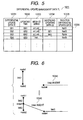
- Fig. 3 is a diagram for explaining the partial updating data.
- a map data is generally divided in its plane into the regions in the shape of lattice called meshes as shown in Fig. 3 and the map data is placed under the management in mesh units.
- Plural links and nodes indicating roads, for example, are stored in the map data in mesh units.
- regions such as administrative districts exist overlapping plural meshes such as the region 01, region 02, etc. in Fig. 3. Therefore, in the case where map data is placed under the management in region units, the management method is employed in which each mesh is assigned to one region not overlapping the regions. In this example, assignment is conducted as follows.
- region boundary mesh ID column TL1031. This is formed of the update object region ID 10311, adjacent region ID 10312, and adjacent mesh ID column 10313.
- adjacent region ID:02 exist for the update object region ID:01 and there are ⁇ m11, m21, m31, m42, m53, and m54 ⁇ as the adjacent mesh ID column when viewed from the region 01. That is, adjacent mesh in this specification means the adjacent mesh of the mesh located in the external side of the meshes under the management corresponding to the predetermined region and the mesh not under the management corresponding to such region.
- the mesh ID column that revision is also required for the adjacent mesh for obtaining matching with the partial updating data.
- the update management data memory 103 includes the partial update management data TL1032, differential update management data TL1033, and region boundary mesh ID column TL1031 explained above.
- the partial update management data TL1032 includes the registered partial update management data as the data for management of partial updating data stored in the update-data memory 170.
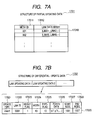
- Fig. 4 schematically shows registered contents of the partial update management data TL1032.
- a record 10320 of the partial update management data includes a field 10321 for registering the partial update region ID as the identification information of the region indicated by the partial updating data, a field 10322 for registering time and date of updating of the partial updating data, and a field 10324 for registering path (memory address) for partial updating data.
- partial updating data file 1701 is shown in Fig. 7A.
- the partial updating data is structured by the records collected as many as the number of meshes within the region and each of such records is formed of link map data related to the mesh ID 17011 and the link data column 170012 existing in such mesh.
- a record 10330 of the differential update management data includes a field 10331 for registering the differential updating data ID as the identification information of the differential updating data, a field 10332 for registering time and date of updating of the differential updating data, a field 10333 for registering map region (mesh ID column) where a map article indicated by the differential updating data, a field 10334 for registering dependent update data to be explained later, and a field 10335 for registering path (memory address) to the differential updating data.
- update overlapping plural adjacent meshes is held with only one differential updating data.
- plural mesh IDs are stored in the field 10332.
- plural depending update data IDs are stored in the field 10334 in some cases.
- the depending update data ID is the other differential updating data giving influence on the connecting relationship of map article and is also the differential updating data ID of differential updating data updated before the time and date of update.
- Fig. 6 is a diagram for explaining depending relationship of the differential updating data. As shown in this figure, it is assumed that the differential updating data A where the node 4 adds a straight road formed of the link 1 and non-connected link 5 is generated (10345) and thereafter the differential updating data B is generated (10346) for changing the straight road formed of the link 1 into the road in the shape of T formed of the link 2, link 3 and link 4.
- the differential updating data A gives influence on the connecting relationship of the map article indicated by the differential updating data B.
- the differential updating data ID of the differential updating data A becomes the depending update data ID of the differential updating data B.
- the differential updating data is formed of one or more link update data.
- a link update data is formed, as indicated in the record 17020, of an update type 17021, a link ID 17022, a height flag 17023, a width 17024, a type flag 17025, a point data 17026, a start node 17027, and an end node 17028.
- each attribute of the link update data is different in existence or non-existence of a value of each attribute in accordance with a value of the update type 17021. For example, when the update type 17021 is inserted, a value is held in all attributes.
- the communication IF 150 executes the update process of map data of the navigation terminal 20 via the communication IF 250 of the navigation terminal 20 through the network 40.
- the updating region indicator 110 indicates the region as the object of update process to the navigation terminal 20. Here, indication by a user or region ID determined as the initial value when the navigation system is delivered is indicated.
- the updating management data generator 120 obtains time and date of updating of the indicated region in the navigation terminal 20 from the update management data memory 203 and moreover the mesh ID located at the boundary between the indicated region and the adjacent region from the update management data memory 103. In addition, the updating management data generator 120 also obtains the differential updating data ID which is already applied in the navigation terminal 20 from the update management data memory 203.
- the update-data selector 130 collects the differential updating data in regard to the boundary of regions of the partial updating data indicated by the region ID designated with the updating region indicator 110 and eliminates the differential updating data ID already applied to the navigation terminal 20 from the collected differential updating data in view of selecting the differential updating data as the update object.
- the map updater 140 executes update process to the navigation terminal 20 using the differential updating data and partial updating data which have been determined as a result of selecting process of update data explained above.
- the map provider 10 explained above can be realized when a CPU 901 executes the predetermined program loaded on a memory 902 in a computer system comprising, for example as shown in Fig. 8, the CPU 901, the memory 902, an external storage 903 such as HDD or the like, a disc reader 905 for reading information from a portable memory medium 904 such as CD-ROM and DVD-ROM, an input device 906 such as keyboard and mouse, an output device 907 such as display, and a communication device 908 for connection to the communication network. It is also possible that this predetermined program may be downloaded to the external storage 903 from the memory medium 904 via the disc reader or from the network via the communication device 908 and may also be executed by the CPU 901 through the loading on the memory 902.
- such program may be downloaded in direct to the memory 902 from the memory medium 904 via the disc reader 905 or from the network through the communication device 908 and thereafter the program is executed by the CPU 901.
- the memory 902, external storage 903 and memory medium 904 are used as the update-data memory 102 and update management data memory 103.
- the navigation terminal 20 executes the navigation process such as map display, route search, and route guidance, etc. using the map data stored therein.
- the navigation terminal 20 includes the network IF 250 for connecting the navigation terminal 20 to the network 40, update management data memory 203, map data memory 270, navigator 280, and GUI (Graphical User Interface) 209 for displaying information to users and accepting indication from users.
- GUI Graphic User Interface
- the update management data memory 203 includes partial update management data TL 2032 and differential update management data TL 2033.
- Fig. 10 is a schematic diagram showing registered contents of the partial update management data TL 2032.
- a record 20320 of the partial update management data includes a field 30321 for registering the partial update region ID as the identification information of the region indicated by the partial updating data and a field 20322 for registering time and date of updating of the partial updating data. Only a record 20320 of the partial update management data for management of the latest time and date of update applied to the map data is registered to the partial update management data TL 2032 in every object region.
- a record 20330 of the differential update management data includes a field 20331 for registering the differential updating data ID as the identification information of the differential updating data, a field 20332 for registering time and date of updating of the differential updating data, a field 20333 for registering existing region (mesh ID column) of map article indicated by the differential updating data, and a field 20334 for registering the depending update data ID explained above.
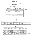
- Fig. 9 is a schematic diagram showing registered contents of map data under the management in the map data memory 270.
- a record 27010 of the map data TL 2701 includes a field 27011 for registering the mesh ID and a field 27012 for registering a link data column indicating the roads existing in the mesh region.
- plural links are stored in arrangement as shown in the figure in the link data columns registered to the link data columns.
- a record 27020 of this link includes a link ID 27022 for identifying the link, a height flag 27023, a width 27024, a type flag 27025 indicating type of road of link such as ordinary road and toll road, a point data 27026 as the coordinate data of points (points formed of start node, end node and intermediate node existing at the curving point of link) showing a shape of link, a start point node 27027 given to the start node of link, and end node 27028 given to the end node of link.
- the navigator 280 executes navigation processes such as map display, route search and route guidance using the link data registered to the map data TL 2701.
- the navigation terminal 20 can be realized when the CPU 901 executes the predetermined program loaded on the memory 902 in a computer system of the structure where a GPS receiver and/or various sensors such as a bearing sensor and a velocity sensor and an I/O device for transmitting and receiving information are provided to the structure, for example, shown in Fig. 8.
- This predetermined program may be downloaded to the external storage 903 from the storage medium 904 via the disc reader 905 or from the network via the communication device 908 and this program may also be executed with the CPU 901 after it has been loaded to the memory 902.
- the memory 902 and external storage 903 are used as the update management data memory 203 and map data memory 270.
- Fig. 12 is a diagram for explaining total operations of a map data distribution system to which an embodiment of the present invention is applied.
- the navigation terminal 20 is connected to the map provider 10 using, for example, a USB cable and a LAN cable to execute the update process of map information stored in the navigation terminal 20 through user operations.
- data can be written in direct to a storage such as HDD provided in the navigation terminal 20 from the map provider 10.
- the partial updating data and differential updating data for update stored in the map provider should be periodically supplied from a map contents providing center or the like provided in separation via the network or a portable storage media or the like.
- the updating region indicator 110 indicates (S100) for indicating the update object from a user via the GUI 109 and the update management data memory 120 obtains time and date of update in the region indicated by S100 by referring to the partial update management data TL 2032 under the management of the update management data memory 203 of the navigation terminal 20 via the communication IF 150.
- the mesh ID adjacent to the boundary of the indicated region by referring to the region boundary mesh ID TL 1031 under the management of the update management data memory 103.
- the differential updating data ID which has already been applied can be obtained by referring to the differential update management data TL 2033 from the update management data memory 203 of the navigation terminal 20 via the communication IF 150 (S101).
- the update-data selector 130 searches the differential update management data TL 1033 under the management of the update management data memory 103 on the basis of the mesh ID of the region boundary obtained from the updating management data generator 120 and obtains the necessary differential updating data ID. Thereafter, the depending update data ID to be applied previously is obtained for application of the differential updating data ID. Finally, a list of the not applied differential updating data IDs is obtained by eliminating the applied differential updating data ID obtained in the S101 from the differential updating data ID to be applied (S102).
- the map updater 140 obtains a path for the partial updating data of the region as the update object determined in the S100 by referring to the update management data memory 103.
- the path for differential updating data determined in each step is obtained.
- the update data to be applied is obtained from the update-data memory 170 on the basis of the path obtained in the above step, the differential updating data and partial updating data are applied to the map data TL 2701 under the management of the map data memory 270 of the navigation terminal 20 via the communication IF 150, and result of application is registered to the partial update management data tL 2032 and the differential update management data TL 2033 under the management of the update management data memory 203 (S103).
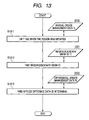
- Fig. 13 is a diagram for explaining detail operations of the step S101.
- a record 20320 of the partial update management data where the region ID corresponding to the region ID designated in the step S100 is registered to the field 20321 is got from the partial update management data TL 2032 to obtain time and date of updating of the map data in the designated region in the navigation terminal 20 (S1011). This time and date of update are used for the process shown in Fig. 15 which will be explained later.
- a record 20330 of the differential update management data where any of the mesh IDs stored in the adjacent mesh ID column held by the record 10310 of the region boundary mesh ID column is registered to the field 20333 is got from the differential update management data TL 2033.
- the record 20330 of the differential update management data where the depending update data ID included in the field 20334 of the record 20330 is extracted from the differential update management data TL 1033. This process is repeated until the record 20330 of the differential update management record including the depending update data ID is eliminated from the extracted field 20334 for each depending update data ID. Accordingly, the differential updating data ID which is already applied in the adjacent mesh as the object can be obtained in the navigation terminal 20 (S1013).
- Fig. 14 is a diagram for explaining detail operations in the step S102.
- the differential updating data as the update object is selected.
- a record 10330 of the differential update management data where any of the update region boundary mesh ID obtained in the step S1012 is registered to the field 10333 is extracted from the differential update management data TL 1033 (S1021).
- the update data of structures updated can be obtained in the adjacent mesh as the object.
- the record 10330 of the differential update management data extracted the record 10330 of the differential update management data where the depending update data ID included in the field 10334 of the relevant record 10330 is registered to the field 10331 as the differential updating data ID is extracted from the differential update management data TL 1033.
- This process should be repeated for each of the record 10330 of the differential update management data extracted until the depending update data ID is eliminated from the field 10334 of the record 10330 of the differential update management data. Accordingly, the differential data of the feature affected by updating of the adjacent mesh can be obtained even in the adjacent mesh other than that as the object (S1021). With the processes explained above, candidates of the differential updating data ID to be updated to the navigation terminal 20 can be obtained.
- the differential updating data ID not yet applied can be determined in the navigation terminal 20 by eliminating the list of the differential updating data ID obtained in the step S1013 (S1023).
- the update object between the designated region and the adjacent region can be selected to the roads ranked higher than the designated roads by further providing type designation of roads at the time of obtaining the differential updating data ID in the step S1021 and then obtaining only the differential updating data ID for update in regard to the roads ranked higher than the designated roads among the differential updating data.
- the update object can be selected to the roads ranked higher than the designated roads by further providing type designation of roads at the time of obtaining the differential updating data ID in the step S1021 and then obtaining only the differential updating data ID for update in regard to the roads ranked higher than the designated roads among the differential updating data.
- Fig. 15 is a diagram for explaining detail operations in the step S103.
- the update data already selected is applied to the map data memory 270 of the navigation terminal 20.
- a record 10320 of the partial update management data where the region ID of the update object is registered to the field 10321 and the time and date of update after the same data obtained in the step S1011 are registered to the field 10322 is obtained from the partial update management data TL 1032.
- a record 10330 of the differential update management data where any of the differential updating data ID obtained in the step S1023 is registered to the field 10331 is searched from the differential update management data TL 1033.
- Both partial updating data file and differential updating data file under the management of the update-data memory 170 are obtained by referring to the path for each update data file of the record obtained by the search explained above. Thereby, the partial updating data and the differential updating data can be obtained as the update object (S1031).
- each differential updating data file obtained in the step S1031 is applied sequentially to the map data TL 2701 from the older time and date of update stored in the record of the differential update management data.
- a record 27010 of the map data registering the mesh ID written in the mesh ID column stored in the record of the differential update management data to the field 27011 is searched from the map data TL 2701 and a record 27020 of the link data matching with the link ID 17023 written in the link update data 1702 in the differential updating data is searched from the link data column stored in the field 27012.
- the record 27010 is deleted in accordance with the value of update type in the 17022, namely when such value is deleted.
- each attribute value is applied.
- the differential updating data ID is registered to the differential update management data TL 2033 (S1032).
- the partial updating data written in the step S1033 is sequentially executed.
- the differential updating data is applied after application of the partial updating data
- the differential updating data is applied after overwriting of the partial updating data to the meshes near the boundary within the designated regions and thereby contradiction due to the double writing is likely generated. Therefore, the sequential applications of the partial updating data after the differential updating data will results in a merit that matching may be maintained only with the simplified process.
- the latest state of the map data of the designated region can be attained by such application process of the partial updating data. Moreover, contradiction among the boundaries has also been eliminated with the update process for the adjacent boundary shown in Fig. 14.
- the application process of this partial updating data is conducted as the overwriting of file in the case of introducing the mounting means for dividing, for example, the map data into the physical data files for each region and then storing such map data into a storage device such as a hard disc. Accordingly, such application process can be done in very higher rate.
- updating in road units at the boundary of update region based on the differential updating data is combined with the updating of the entire part of the designated region based on the partial updating data.
- the update process is executed in mesh units also for the boundary of update region, contradiction is generated in connection of new roads when new roads exist in the boundary in the opposite side of the update region among the boundaries of the adjacent meshes. Therefore, in this case, the external meshes are considered as the update object.
- spread of updating of mesh cannot be stopped in order to eliminate contradiction in the boundary by conducting update in mesh units as explained above. Or, when the scope of updating is restricted in the course of process, discontinuity of road is likely generated at the boundary of mesh.
- the road newly arranged at the boundary of the designated region and the adjacent region and moreover the road in the depending relationship with such road namely only the roads required for connection with the existing roads at the external side of the designated region are considered as the update objects and these roads can be added for the minimum update required for connection of roads.
- Such difference will make it possible for users to expect that the time required for update process can be reduced by limiting the update object.
- connections of roads are maintained, connections of roads to the external side from the designated region can also be maintained as well as the roads within the designated region and moreover the navigation process such as route search functions normally.
- the similar map update process can also be realized by arranging each processor provided in the map provider 10 of Fig. 1 in the navigation terminal 20, and newly providing a media reader 280 to read the necessary information from a map data medium 30 recording the update management data 303 and update data 370.
- a user can effectively update the predetermined region without any contradiction quickly only by using the map data medium corresponding to a portable storage media such as DVD and USB memory without connection to the map provider 10.
- new map data can be stored into the map data medium, it is also possible to additionally provide a device such as a PC, periodically obtain the new map information from the map providing center via the network connected to the same device and to write the map information to the map data medium. Accordingly, it is also possible to get a merit that a user can obtain a new map in the desired timing.
- Fig. 17 shows flow of processes when the structure of Fig. 16 is introduced.
- differences may be found in the points that the processes up to the step S103 from the step S100 are executed in the navigation terminal 20 and that reference is made to the update management data 303 and update data 370 via the data reader 280 because of above difference.
- the processing contents are identical.
- the updating region indicator 110 and map updater 140 among the units provided in the map provider 10 in Fig. 1 within the navigation terminal 20.
- region indication is conducted by a user via the GUI 209 of the navigation terminal 20 and that the process (Fig. 15) for applying the update data obtained from the map provider 10 to the update management data memory 203 and map data memory 270 is executed in the navigation terminal 20.
- search of data for updating in the step S1031 among the processes shown in Fig. 15 may also be executed with the map provider 10.
- the map provider 10 is not required to be adjacent to the navigation terminal 20.
- this map provider 10 may be installed at the remote region connected, for example, through a portable phone and the network 40 of LAN, resulting in the merit that the update data can be obtained through the communication and restriction of place for update process applied on users can also be eliminated.
- distribution object is considered as the update data of link forming the road.
- the present invention is not limited thereto. Namely, update data of link forming a railway and update data of the map element other than the link data may also be considered as the distribution object.
- map data memory 206 it is also possible in the embodiment explained above to update the map data memory 206 by eliminating, for example, the navigator 207 from the navigation terminal 20 and connecting a terminal which can unload the map data memory 206 to the network 40. It is additionally possible to remove the map data memory 206 from the terminal and then load this memory to the navigator prepared separately.
Landscapes
- Engineering & Computer Science (AREA)
- Remote Sensing (AREA)
- Radar, Positioning & Navigation (AREA)
- General Physics & Mathematics (AREA)
- Physics & Mathematics (AREA)
- Automation & Control Theory (AREA)
- Databases & Information Systems (AREA)
- Theoretical Computer Science (AREA)
- General Engineering & Computer Science (AREA)
- Data Mining & Analysis (AREA)
- Navigation (AREA)
- Instructional Devices (AREA)
- Information Retrieval, Db Structures And Fs Structures Therefor (AREA)
- Traffic Control Systems (AREA)
Applications Claiming Priority (1)
| Application Number | Priority Date | Filing Date | Title |
|---|---|---|---|
| JP2006065029A JP5183029B2 (ja) | 2006-03-10 | 2006-03-10 | 地図更新プログラム及び地図更新端末 |
Publications (2)
| Publication Number | Publication Date |
|---|---|
| EP1832990A1 true EP1832990A1 (de) | 2007-09-12 |
| EP1832990B1 EP1832990B1 (de) | 2019-06-19 |
Family
ID=38157962
Family Applications (1)
| Application Number | Title | Priority Date | Filing Date |
|---|---|---|---|
| EP07001341.2A Active EP1832990B1 (de) | 2006-03-10 | 2007-01-22 | Computerlesbarer Datenträger mit einem darauf gespeicherten Programm zur Aktualisierung von Kartendaten |
Country Status (4)
| Country | Link |
|---|---|
| US (1) | US7930100B2 (de) |
| EP (1) | EP1832990B1 (de) |
| JP (1) | JP5183029B2 (de) |
| CN (1) | CN100545844C (de) |
Cited By (5)
| Publication number | Priority date | Publication date | Assignee | Title |
|---|---|---|---|---|
| EP2306336A1 (de) * | 2009-09-28 | 2011-04-06 | E-Technology Masters' srl | Verfahren zur automatischen gleichzeitigen Aktualisierung von Straßendaten für geografisches Informationssystem (GIS) |
| EP2306337A1 (de) * | 2009-09-28 | 2011-04-06 | E-Technology Masters' srl | Verfahren zum Sammeln von Hausnummern für geografisches Informationssystem |
| CN108932331A (zh) * | 2018-07-05 | 2018-12-04 | 腾讯科技(深圳)有限公司 | 一种地图数据更新方法、装置及系统 |
| US10444025B2 (en) | 2013-01-30 | 2019-10-15 | Here Global B.V. | Method and apparatus for use in navigational applications |
| US11692846B2 (en) | 2018-03-28 | 2023-07-04 | Hitachi Astemo, Ltd. | Map presentation device |
Families Citing this family (52)
| Publication number | Priority date | Publication date | Assignee | Title |
|---|---|---|---|---|
| JP2005214779A (ja) * | 2004-01-29 | 2005-08-11 | Xanavi Informatics Corp | ナビゲーション装置および地図データ更新方法 |
| US7590490B2 (en) * | 2006-01-09 | 2009-09-15 | Mitac International Corporation | Smart detour |
| US7945386B2 (en) | 2006-08-25 | 2011-05-17 | Mitac International Corporation | Rerouting in vehicle navigation systems |
| JP4663620B2 (ja) | 2006-12-07 | 2011-04-06 | 日立オートモティブシステムズ株式会社 | 車載情報端末、地図サーバ、および車載システム |
| US7692655B2 (en) | 2007-02-16 | 2010-04-06 | Mitac International Corporation | Apparatus and method of generating curved baseline for map labeling |
| US7783417B2 (en) | 2007-03-09 | 2010-08-24 | Mitac International Corporation | Methods and apparatus for determining a route having an estimated minimum fuel usage for a vehicle |
| US7835863B2 (en) * | 2007-04-18 | 2010-11-16 | Mitac International Corporation | Method and system for navigation using GPS velocity vector |
| US8078641B2 (en) | 2007-04-25 | 2011-12-13 | Mitac International Corporation | Adjusting spatial operations based on map density |
| JP4335935B2 (ja) * | 2007-07-05 | 2009-09-30 | 本田技研工業株式会社 | ナビサーバ、ナビシステム |
| US7882102B2 (en) | 2007-09-10 | 2011-02-01 | Mitac International Corporation | Nearest-neighbor geographic search |
| US8554475B2 (en) | 2007-10-01 | 2013-10-08 | Mitac International Corporation | Static and dynamic contours |
| US20090138190A1 (en) * | 2007-11-26 | 2009-05-28 | Magellan Navigation, Inc. | System and Method of Providing Traffic Data to a Mobile Device |
| JP5189838B2 (ja) * | 2007-12-27 | 2013-04-24 | 日立オートモティブシステムズ株式会社 | 地図データ配信システム、地図データ配信方法及び通信端末 |
| US8498808B2 (en) | 2008-01-18 | 2013-07-30 | Mitac International Corp. | Method and apparatus for hybrid routing using breadcrumb paths |
| US8700314B2 (en) | 2008-01-18 | 2014-04-15 | Mitac International Corporation | Method and apparatus to search for local parking |
| US8290703B2 (en) | 2008-01-18 | 2012-10-16 | Mitac International Corporation | Method and apparatus for access point recording using a position device |
| US8249804B2 (en) | 2008-08-20 | 2012-08-21 | Mitac International Corporation | Systems and methods for smart city search |
| US8219317B2 (en) | 2008-09-22 | 2012-07-10 | Mitac International Corporation | Route navigation via a proximity point |
| JP4743256B2 (ja) * | 2008-10-30 | 2011-08-10 | 株式会社デンソー | データ処理装置 |
| JPWO2011013177A1 (ja) * | 2009-07-31 | 2013-01-07 | 三菱電機株式会社 | 施設検索装置 |
| CN102597700B (zh) * | 2009-10-21 | 2015-05-06 | 三菱电机株式会社 | 地图信息处理装置 |
| JP5345084B2 (ja) * | 2010-02-08 | 2013-11-20 | 三菱電機株式会社 | 地図情報処理装置 |
| JP5471626B2 (ja) * | 2010-03-09 | 2014-04-16 | ソニー株式会社 | 情報処理装置、マップ更新方法、プログラム及び情報処理システム |
| JP5511060B2 (ja) * | 2010-03-23 | 2014-06-04 | アイシン・エィ・ダブリュ株式会社 | 地図更新データ供給装置及び地図更新データ供給プログラム |
| US20110258644A1 (en) * | 2010-04-15 | 2011-10-20 | Kaleidescape, Inc. | Utilizing a disc vault |
| WO2011148416A1 (ja) * | 2010-05-26 | 2011-12-01 | 三菱電機株式会社 | 地図情報処理装置 |
| CN101936741B (zh) * | 2010-07-23 | 2012-02-22 | 中国科学院东北地理与农业生态研究所 | 基于逆向基图修正时空数据模型的车载导航路网增量数据更新系统 |
| US8310361B1 (en) * | 2011-06-13 | 2012-11-13 | Google Inc. | Creating and monitoring alerts for a geographical area |
| JP5732340B2 (ja) * | 2011-07-21 | 2015-06-10 | 株式会社日立製作所 | 地図データ配信サーバ、地図データ配信システム及び地図データ配信方法 |
| JP2013029595A (ja) * | 2011-07-27 | 2013-02-07 | Denso Corp | 地図差分データ作成装置及び地図差分データ作成方法 |
| CN103575266B (zh) * | 2012-08-06 | 2017-02-08 | 百度在线网络技术(北京)有限公司 | 移动导航的方法、系统和gis服务器 |
| CN102930049B (zh) * | 2012-11-16 | 2015-07-29 | 沈阳美行科技有限公司 | 一种支持增量更新的嵌入式用户兴趣点数据编译方法 |
| JP6006113B2 (ja) | 2012-12-28 | 2016-10-12 | 株式会社日立製作所 | カーナビケーション装置用地図配信サーバ、地図データ配信システム及び道路差分データ生成方法 |
| JP6036509B2 (ja) * | 2013-04-16 | 2016-11-30 | 株式会社デンソー | 地図差分データ配信システム、地図差分データ配信装置、地図データ保有装置、更新管理サーバ、及び地図差分抽出サーバ |
| JP6142638B2 (ja) * | 2013-04-16 | 2017-06-07 | 株式会社デンソー | 地図差分データ配信システム、地図差分データ配信装置、及び地図差分抽出サーバ |
| US9933267B2 (en) * | 2013-05-27 | 2018-04-03 | Mitsubishi Electric Corporation | Navigation device and navigation method |
| CN104215251A (zh) * | 2013-05-31 | 2014-12-17 | 北京图盟科技有限公司 | 导航电子地图中导航拓扑数据的更新方法及相关装置 |
| CN103414995B (zh) * | 2013-08-16 | 2016-05-18 | 五八同城信息技术有限公司 | 基于四叉树的区域边界探测方法 |
| US9581450B2 (en) * | 2013-10-09 | 2017-02-28 | Telenav, Inc. | Navigation system with content retrieving mechanism and method of operation thereof |
| JP2015082045A (ja) * | 2013-10-23 | 2015-04-27 | 株式会社デンソー | 地図データ配信システム、サーバ、及びナビゲーション装置 |
| CN104742745B (zh) * | 2015-03-24 | 2017-12-15 | 郑州宇通客车股份有限公司 | 一种智能分路段车辆限速控制系统及方法 |
| US10593074B1 (en) * | 2016-03-16 | 2020-03-17 | Liberty Mutual Insurance Company | Interactive user interface for displaying geographic boundaries |
| EP3385675A4 (de) | 2016-03-28 | 2018-12-19 | Aisin Aw Co., Ltd. | Kommunikationsendgerät, servervorrichtung, bewegungsführungssystem und computerprogramm |
| JP6718715B2 (ja) * | 2016-03-28 | 2020-07-08 | アイシン・エィ・ダブリュ株式会社 | 通信端末、サーバ装置、移動案内システム及びコンピュータプログラム |
| JP6813347B2 (ja) | 2016-12-12 | 2021-01-13 | アイシン・エィ・ダブリュ株式会社 | 通信端末、移動案内システム及びコンピュータプログラム |
| JP6803279B2 (ja) * | 2017-03-28 | 2020-12-23 | クラリオン株式会社 | 車載装置、地図更新システム |
| CN108663056B (zh) * | 2017-03-30 | 2023-08-11 | 阿里巴巴(中国)有限公司 | 一种道路连通方法及装置 |
| CN107192393B (zh) * | 2017-07-20 | 2019-11-12 | 南京多伦科技股份有限公司 | 一种道路地图数据的维护系统及方法 |
| CN109855633B (zh) * | 2018-10-31 | 2021-01-05 | 百度在线网络技术(北京)有限公司 | 地图更新方法、装置、设备及存储介质 |
| CN109783125A (zh) * | 2019-01-23 | 2019-05-21 | 苏州翔云瑞图信息技术有限公司 | 应用于自动驾驶的高精地图差分更新方法 |
| CN110006439B (zh) * | 2019-04-12 | 2021-01-29 | 北京百度网讯科技有限公司 | 地图轨迹数据的匹配方法、装置、服务器及存储介质 |
| CN114238384B (zh) * | 2022-02-24 | 2022-08-30 | 阿里云计算有限公司 | 区域定位方法、装置、设备和存储介质 |
Citations (8)
| Publication number | Priority date | Publication date | Assignee | Title |
|---|---|---|---|---|
| JP2003044992A (ja) | 2001-07-31 | 2003-02-14 | Pioneer Electronic Corp | 通信ナビゲーションシステムにおける地図データの更新方法およびサーバ装置、記録媒体、通信ナビゲーション端末装置 |
| US20030220735A1 (en) | 2002-04-25 | 2003-11-27 | Aisin Aw Co., Ltd. | Navigation system |
| JP2004077254A (ja) | 2002-08-15 | 2004-03-11 | Alpine Electronics Inc | ナビゲーションシステム、地図差分データの配信装置、及び車載用ナビゲーション装置 |
| JP2004178248A (ja) | 2002-11-27 | 2004-06-24 | Xanavi Informatics Corp | 地図情報提供装置および地図情報提供プログラム |
| US20040125989A1 (en) * | 2002-12-19 | 2004-07-01 | Masahiro Kimura | Electronic device and program |
| WO2005106392A1 (ja) * | 2004-04-30 | 2005-11-10 | Pioneer Corporation | 地点検索装置、ナビゲーション装置、地点検索方法並びに地点検索プログラム及びこの地点検索プログラムを記録した情報記録媒体 |
| WO2006011278A1 (ja) | 2004-07-29 | 2006-02-02 | Hitachi, Ltd. | 地図データ配信装置、通信端末および地図配信方法 |
| JP2006065029A (ja) | 2004-08-27 | 2006-03-09 | Matsushita Electric Ind Co Ltd | 同期型データ転送システム、この同期型データ転送システムに用いられるsdio規格に準拠したモジュール、sdioホストコントローラ及びこのsdioホストコントローラを用いた電子機器 |
Family Cites Families (6)
| Publication number | Priority date | Publication date | Assignee | Title |
|---|---|---|---|---|
| JP3332225B2 (ja) * | 1998-11-24 | 2002-10-07 | 松下電器産業株式会社 | 地図提供システム |
| KR100735441B1 (ko) * | 2002-05-17 | 2007-07-04 | 가부시키가이샤 자나비 인포메틱스 | 지도 구조를 가진 데이터를 기록한 기억매체, 지도 데이터 처리 프로그램을 기록한 기억매체, 지도 데이터 처리 방법 및 지도 데이터 처리 장치 |
| JP4080308B2 (ja) * | 2002-11-27 | 2008-04-23 | 株式会社ザナヴィ・インフォマティクス | 地図情報処理装置および地図情報処理プログラム |
| JP4080307B2 (ja) * | 2002-11-27 | 2008-04-23 | 株式会社ザナヴィ・インフォマティクス | 地図情報処理装置および地図情報処理プログラム |
| JP4065202B2 (ja) * | 2003-01-07 | 2008-03-19 | 三菱電機株式会社 | 地図データ処理装置およびセンターシステム |
| JP2005122003A (ja) | 2003-10-20 | 2005-05-12 | Matsushita Electric Ind Co Ltd | 地図データ更新システム |
-
2006
- 2006-03-10 JP JP2006065029A patent/JP5183029B2/ja active Active
-
2007
- 2007-01-19 CN CNB2007100039707A patent/CN100545844C/zh active Active
- 2007-01-22 EP EP07001341.2A patent/EP1832990B1/de active Active
- 2007-02-02 US US11/701,469 patent/US7930100B2/en active Active
Patent Citations (10)
| Publication number | Priority date | Publication date | Assignee | Title |
|---|---|---|---|---|
| JP2003044992A (ja) | 2001-07-31 | 2003-02-14 | Pioneer Electronic Corp | 通信ナビゲーションシステムにおける地図データの更新方法およびサーバ装置、記録媒体、通信ナビゲーション端末装置 |
| US20030220735A1 (en) | 2002-04-25 | 2003-11-27 | Aisin Aw Co., Ltd. | Navigation system |
| JP2004077254A (ja) | 2002-08-15 | 2004-03-11 | Alpine Electronics Inc | ナビゲーションシステム、地図差分データの配信装置、及び車載用ナビゲーション装置 |
| JP2004178248A (ja) | 2002-11-27 | 2004-06-24 | Xanavi Informatics Corp | 地図情報提供装置および地図情報提供プログラム |
| US20040125989A1 (en) * | 2002-12-19 | 2004-07-01 | Masahiro Kimura | Electronic device and program |
| WO2005106392A1 (ja) * | 2004-04-30 | 2005-11-10 | Pioneer Corporation | 地点検索装置、ナビゲーション装置、地点検索方法並びに地点検索プログラム及びこの地点検索プログラムを記録した情報記録媒体 |
| EP1742019A1 (de) * | 2004-04-30 | 2007-01-10 | Pioneer Design Corporation | Punktsucheinrichtung, navigationseinrichtung, punktsuchverfahren, punktsuchprogramm und informationsaufzeichnungsmedium, worauf das punktsuchprogramm aufgeezeichnet wird |
| WO2006011278A1 (ja) | 2004-07-29 | 2006-02-02 | Hitachi, Ltd. | 地図データ配信装置、通信端末および地図配信方法 |
| EP1785968A1 (de) * | 2004-07-29 | 2007-05-16 | Hitachi, Ltd. | Kartendaten-abliefereinrichtung, kommunikationsendgerät und kartenablieferverfahren |
| JP2006065029A (ja) | 2004-08-27 | 2006-03-09 | Matsushita Electric Ind Co Ltd | 同期型データ転送システム、この同期型データ転送システムに用いられるsdio規格に準拠したモジュール、sdioホストコントローラ及びこのsdioホストコントローラを用いた電子機器 |
Cited By (5)
| Publication number | Priority date | Publication date | Assignee | Title |
|---|---|---|---|---|
| EP2306336A1 (de) * | 2009-09-28 | 2011-04-06 | E-Technology Masters' srl | Verfahren zur automatischen gleichzeitigen Aktualisierung von Straßendaten für geografisches Informationssystem (GIS) |
| EP2306337A1 (de) * | 2009-09-28 | 2011-04-06 | E-Technology Masters' srl | Verfahren zum Sammeln von Hausnummern für geografisches Informationssystem |
| US10444025B2 (en) | 2013-01-30 | 2019-10-15 | Here Global B.V. | Method and apparatus for use in navigational applications |
| US11692846B2 (en) | 2018-03-28 | 2023-07-04 | Hitachi Astemo, Ltd. | Map presentation device |
| CN108932331A (zh) * | 2018-07-05 | 2018-12-04 | 腾讯科技(深圳)有限公司 | 一种地图数据更新方法、装置及系统 |
Also Published As
| Publication number | Publication date |
|---|---|
| JP5183029B2 (ja) | 2013-04-17 |
| CN100545844C (zh) | 2009-09-30 |
| US7930100B2 (en) | 2011-04-19 |
| EP1832990B1 (de) | 2019-06-19 |
| US20070213929A1 (en) | 2007-09-13 |
| JP2007241003A (ja) | 2007-09-20 |
| CN101030214A (zh) | 2007-09-05 |
Similar Documents
| Publication | Publication Date | Title |
|---|---|---|
| EP1832990B1 (de) | Computerlesbarer Datenträger mit einem darauf gespeicherten Programm zur Aktualisierung von Kartendaten | |
| JP5327497B2 (ja) | 地図データ配信システム及び地図データ更新方法 | |
| JP4684228B2 (ja) | 地図データ配信装置、通信端末および地図配信方法 | |
| US8706693B2 (en) | Map update data delivery method, map update data delivery device and terminal device | |
| JP5189838B2 (ja) | 地図データ配信システム、地図データ配信方法及び通信端末 | |
| US8249801B2 (en) | Navigation device and map data updating method thereof | |
| US8799246B2 (en) | Apparatus and method of producing map differential data | |
| US7318054B2 (en) | Update system and update method for updating search data | |
| KR101136684B1 (ko) | 데이터 갱신 시스템, 네비게이션 장치, 서버 장치, 및 데이터 갱신 방법 | |
| JP2008090195A (ja) | 地図データ配信システム | |
| CN100513999C (zh) | 地图更新处理用数据生成方法、地图更新方法和装置 | |
| JP2008089375A (ja) | データ更新システム、ナビゲーション装置、及びデータ更新方法 | |
| US20120066240A1 (en) | Facility search device | |
| JP2006220524A (ja) | 地図更新処理用データ作成方法、地図更新方法及び装置 | |
| JP2006317643A (ja) | 地図データ配信装置、通信端末および地図配信方法 | |
| CN101965499B (zh) | 使用动态高速缓存存储器的地图更新系统和地图更新程序 | |
| JP5388893B2 (ja) | 地図データ配信サーバ、地図更新方法、及び地図データ配信システム | |
| CN104995485B (zh) | 用于车辆使用记录的方法及设备 | |
| JP2015082045A (ja) | 地図データ配信システム、サーバ、及びナビゲーション装置 | |
| JP5225380B2 (ja) | 地図データ更新装置、更新地図データ作成装置、地図データ更新方法、更新地図データ作成方法、地図データ更新プログラム、更新地図データ作成プログラム、および記録媒体 | |
| KR101637593B1 (ko) | 지도 데이터의 부분 업데이트 시스템 | |
| JP2011215219A (ja) | 孤立道路抽出装置 | |
| JP2008089376A (ja) | データ更新システム及び方法並びにナビゲーション装置 |
Legal Events
| Date | Code | Title | Description |
|---|---|---|---|
| PUAI | Public reference made under article 153(3) epc to a published international application that has entered the european phase |
Free format text: ORIGINAL CODE: 0009012 |
|
| AK | Designated contracting states |
Kind code of ref document: A1 Designated state(s): AT BE BG CH CY CZ DE DK EE ES FI FR GB GR HU IE IS IT LI LT LU LV MC NL PL PT RO SE SI SK TR |
|
| AX | Request for extension of the european patent |
Extension state: AL BA HR MK RS YU |
|
| 17P | Request for examination filed |
Effective date: 20080312 |
|
| AKX | Designation fees paid |
Designated state(s): DE FR GB IT |
|
| 17Q | First examination report despatched |
Effective date: 20120904 |
|
| REG | Reference to a national code |
Ref country code: DE Ref legal event code: R079 Ref document number: 602007058613 Country of ref document: DE Free format text: PREVIOUS MAIN CLASS: G06F0017300000 Ipc: G01C0021320000 |
|
| GRAP | Despatch of communication of intention to grant a patent |
Free format text: ORIGINAL CODE: EPIDOSNIGR1 |
|
| RIC1 | Information provided on ipc code assigned before grant |
Ipc: G01C 21/32 20060101AFI20190115BHEP Ipc: G09B 29/10 20060101ALI20190115BHEP Ipc: G06F 16/29 20190101ALI20190115BHEP |
|
| INTG | Intention to grant announced |
Effective date: 20190218 |
|
| GRAS | Grant fee paid |
Free format text: ORIGINAL CODE: EPIDOSNIGR3 |
|
| GRAA | (expected) grant |
Free format text: ORIGINAL CODE: 0009210 |
|
| AK | Designated contracting states |
Kind code of ref document: B1 Designated state(s): DE FR GB IT |
|
| REG | Reference to a national code |
Ref country code: GB Ref legal event code: FG4D |
|
| REG | Reference to a national code |
Ref country code: DE Ref legal event code: R096 Ref document number: 602007058613 Country of ref document: DE |
|
| REG | Reference to a national code |
Ref country code: DE Ref legal event code: R097 Ref document number: 602007058613 Country of ref document: DE |
|
| PLBE | No opposition filed within time limit |
Free format text: ORIGINAL CODE: 0009261 |
|
| STAA | Information on the status of an ep patent application or granted ep patent |
Free format text: STATUS: NO OPPOSITION FILED WITHIN TIME LIMIT |
|
| 26N | No opposition filed |
Effective date: 20200603 |
|
| PGFP | Annual fee paid to national office [announced via postgrant information from national office to epo] |
Ref country code: IT Payment date: 20221213 Year of fee payment: 17 |
|
| PGFP | Annual fee paid to national office [announced via postgrant information from national office to epo] |
Ref country code: GB Payment date: 20231130 Year of fee payment: 18 |
|
| PGFP | Annual fee paid to national office [announced via postgrant information from national office to epo] |
Ref country code: FR Payment date: 20231212 Year of fee payment: 18 |
|
| PGFP | Annual fee paid to national office [announced via postgrant information from national office to epo] |
Ref country code: DE Payment date: 20231128 Year of fee payment: 18 |