EP1519152A1 - Device and method for displaying driving instructions - Google Patents
Device and method for displaying driving instructions Download PDFInfo
- Publication number
- EP1519152A1 EP1519152A1 EP04020752A EP04020752A EP1519152A1 EP 1519152 A1 EP1519152 A1 EP 1519152A1 EP 04020752 A EP04020752 A EP 04020752A EP 04020752 A EP04020752 A EP 04020752A EP 1519152 A1 EP1519152 A1 EP 1519152A1
- Authority
- EP
- European Patent Office
- Prior art keywords
- reliability
- vehicle
- navigation
- environment
- navigation instructions
- Prior art date
- Legal status (The legal status is an assumption and is not a legal conclusion. Google has not performed a legal analysis and makes no representation as to the accuracy of the status listed.)
- Granted
Links
- 238000000034 method Methods 0.000 title claims description 17
- 238000012937 correction Methods 0.000 claims abstract description 16
- 230000007613 environmental effect Effects 0.000 claims description 8
- 230000001419 dependent effect Effects 0.000 claims description 5
- 238000004891 communication Methods 0.000 claims description 4
- 238000001514 detection method Methods 0.000 claims description 3
- 239000011521 glass Substances 0.000 claims description 3
- 230000001133 acceleration Effects 0.000 claims description 2
- 238000003384 imaging method Methods 0.000 description 4
- 230000000694 effects Effects 0.000 description 3
- 238000003909 pattern recognition Methods 0.000 description 3
- 230000033228 biological regulation Effects 0.000 description 2
- 238000011156 evaluation Methods 0.000 description 2
- 238000005259 measurement Methods 0.000 description 2
- 238000004364 calculation method Methods 0.000 description 1
- 238000005352 clarification Methods 0.000 description 1
- 230000000295 complement effect Effects 0.000 description 1
- 238000010276 construction Methods 0.000 description 1
- 230000007423 decrease Effects 0.000 description 1
- 238000004519 manufacturing process Methods 0.000 description 1
- 239000003550 marker Substances 0.000 description 1
- 230000004297 night vision Effects 0.000 description 1
- 230000003287 optical effect Effects 0.000 description 1
- 238000012545 processing Methods 0.000 description 1
- 238000004904 shortening Methods 0.000 description 1
- 230000001629 suppression Effects 0.000 description 1
- 230000000007 visual effect Effects 0.000 description 1
Images
Classifications
-
- G—PHYSICS
- G01—MEASURING; TESTING
- G01C—MEASURING DISTANCES, LEVELS OR BEARINGS; SURVEYING; NAVIGATION; GYROSCOPIC INSTRUMENTS; PHOTOGRAMMETRY OR VIDEOGRAMMETRY
- G01C21/00—Navigation; Navigational instruments not provided for in groups G01C1/00 - G01C19/00
- G01C21/26—Navigation; Navigational instruments not provided for in groups G01C1/00 - G01C19/00 specially adapted for navigation in a road network
- G01C21/34—Route searching; Route guidance
- G01C21/36—Input/output arrangements for on-board computers
- G01C21/3626—Details of the output of route guidance instructions
- G01C21/365—Guidance using head up displays or projectors, e.g. virtual vehicles or arrows projected on the windscreen or on the road itself
-
- G—PHYSICS
- G01—MEASURING; TESTING
- G01C—MEASURING DISTANCES, LEVELS OR BEARINGS; SURVEYING; NAVIGATION; GYROSCOPIC INSTRUMENTS; PHOTOGRAMMETRY OR VIDEOGRAMMETRY
- G01C21/00—Navigation; Navigational instruments not provided for in groups G01C1/00 - G01C19/00
- G01C21/26—Navigation; Navigational instruments not provided for in groups G01C1/00 - G01C19/00 specially adapted for navigation in a road network
- G01C21/28—Navigation; Navigational instruments not provided for in groups G01C1/00 - G01C19/00 specially adapted for navigation in a road network with correlation of data from several navigational instruments
-
- G—PHYSICS
- G01—MEASURING; TESTING
- G01C—MEASURING DISTANCES, LEVELS OR BEARINGS; SURVEYING; NAVIGATION; GYROSCOPIC INSTRUMENTS; PHOTOGRAMMETRY OR VIDEOGRAMMETRY
- G01C21/00—Navigation; Navigational instruments not provided for in groups G01C1/00 - G01C19/00
- G01C21/26—Navigation; Navigational instruments not provided for in groups G01C1/00 - G01C19/00 specially adapted for navigation in a road network
- G01C21/34—Route searching; Route guidance
- G01C21/36—Input/output arrangements for on-board computers
- G01C21/3626—Details of the output of route guidance instructions
- G01C21/3632—Guidance using simplified or iconic instructions, e.g. using arrows
Definitions
- the invention relates to a device and a method for Representation of driving instructions for vehicle navigation in one Picture of the vehicle environment.
- DE 101 38 719 A1 discloses a method and a device for displaying driving instructions in the vehicle, which determined by a navigation system driving instructions projected onto the windshield or into one of a picture of the environment captured by a video camera, which is shown on the display of the navigation system becomes.
- the driving instructions are in the form of virtual2-1n trains or arrows from the perspective of the driver or the camera the way to be hit on the windshield or on the display in accordance with the front of the vehicle Mark road, shown.
- the orientation of the displayed Navigation instructions in the image of the vehicle environment is doing according to the satellite-based position determination of the navigation system.
- the display of branches also at uphill and downhill from the perspective of Driver or the camera are correct is from the GPS position data of the vehicle - possibly supported by dead reckoning - and the location of the vehicle with the help of a 3D terrain model a corresponding shortening or extension of the lines.
- a positioning for the vehicle with the help of a satellite-based Systems delivers because of inevitable mistakes Position information with different deviation from the real position of the vehicle.
- Such deviations can may be reduced by dead reckoning, but with larger ones Errors concerning the position determination - for example through reflections or in areas where the reception the satellite signals are disturbed - are larger deviations unavoidable, so that environmental driving advice not exactly enough in line with the environment can be brought. That is, the driver on the Projection screen displayed virtual marked road appears, for example, next to the actual roadway offset; Under certain circumstances, even the roadway with marked oncoming traffic, or the image jumps back and forth. This is necessarily irritating for the driver and draws his attention from the actual traffic from.
- Be navigation instructions in a picture of the vehicle environment (this can be a video image on a display or a head-up display in connection with the windscreen), for example represented in the form of lines or arrows, the align themselves on the road, or as markings, the refer to prominent points of the vehicle environment, shown, It is important that these notes with as possible continuous precision in the image of the vehicle environment be fitted.
- WO 03 005 102 A1 describes a head-up display system and a method for one - in terms of the view of one Vehicle occupants correct - Marking objects in the vehicle environment.
- the location-correct or location-related representation taken from the perspective of a vehicle occupant on its detected by sensors head or eye position.
- the objects to be marked essentially relate to other road users or traffic signs.
- the to be marked Objects of the vehicle environment are thereby using Cameras and pattern recognition identified and for marking modeled on the windshield suitable. It is also thought of a visual implementation of navigation data, in which case the road to be traveled or a junction is marked for the driver's view on the head-up display.
- the object of the invention is an apparatus and a method with an always reliably interpretable representation of navigation hints in a picture of the driving environment to accomplish.
- the inventive method makes the representation of the Navigation system determined navigation instructions of the reliability that determined by a satellite-based system Position indication for the vehicle dependent.
- the image generation unit generates the navigation hint determined by the navigation system So always in a form of representation, according to the reliability achievable for the position indication for the driver is best recorded and the least distraction brings with it.
- a navigation or driving advice may be provided by the imaging unit for example, with highly accurate position information comfortable for the driver as virtual, the road creates the following lines and precise in a picture of Vehicle environment displayed on a projection screen in the vehicle become. Is the reliability of the position information for a satisfactory presentation of driving instructions with direct reference to the environment but too low, switches convert the image generation unit to other forms of representation, for example, on schematic arrows or virtual traffic signs, from which the driver does not expect them optically adapt to the changing environment. schematically or abstract navigation information displayed on a fixed space on the screen or A reference of the driving instruction to the environment is strongly damped tracked. The more abstract forms of representation Significance lost in comparison to representations relating to the environment the hint shown, for example, by supporting acoustic hints are compensated.
- the determination of reliability for those by the satellite System determined position information is advantageous through a collection and evaluation of the statistical Values which satellite systems usually to indicate the accuracy of the determined position. These Values are used by the navigation system when determining the position with, and from this to the device for the determination Reliability passed.
- the reliability itself can be used as a statistical measure in various sizes, for example as a standard deviation or an error probability be expressed.
- the position indication is advantageous by correction data of a Ground station specified, while also the reliability corrected with values for the reliability of this specification becomes.
- the device for determining the Position indication the data for correcting the position by the navigation system, which this data and also the data on the reliability of this position correction from the ground station receives, and the data to correct the reliability to the device for determining reliability transmitted.
- the correction of the reliability determination can also be the amount of correction to the position was improved. Receives this difference the navigation system of the device for the determination the position information.
- position corrections as for satellite Navigation systems by receiving signals from permanently measured Ground stations, for example, by differential GPS are possible, the accuracy of the position information advantageous to be improved by several meters. This helps in Areas where the reception of such stations possible is the position of a vehicle with a high reliability to determine. In such areas, the inventive System object - related navigation instructions on the Projection surface in sufficient accordance with the Represent objects of the vehicle environment.
- the position information for the vehicle can be further improved by comparing the determined position with a digital map becomes (lane-matching). Also such a position adjustment in turn leads to increased reliability for the position indication, whereby the improvement becomes greater, the more accurate the digital map is.
- the Reliability accordingly with values for the reliability this clarification is corrected.
- These are the vehicle-mounted sensors with the device for determination the position information connected by the sensors the data to correct the position information receives.
- the device for determining the reliability receives from the vehicle sensors Data for the corresponding correction of reliability. These data relate to the reliability of the sensors or their measurements.
- the advantage of position corrections with the help of the vehicle Sensors consists mainly in that hereby a disturbed Reception of the necessary for the position determination Satellite signals can be bridged or compensated.
- the satellite signals can be high and dense Buildings reflected or in forests by dense foliage be shaded in places, leaving the position for a presentation of driving instructions related to the real Environment are no longer sufficient can be determined exactly.
- Multipath effects can for example, by a second antenna for the reception of Satellite position data on the vehicle, with the largest possible Distance to the first antenna, by difference calculations Getting corrected.
- a particularly advantageous possibility for relative precision the position indication consists in the employment of a video-supported Lane detection, the result of which is a correction of the Position indication in lateral direction allowed. With night vision devices This is reliably possible even at night.
- a Precision of the position information in the lateral direction is just for a presentation of navigation hints as virtual Road markings of particular importance to it the virtual marker will not accidentally be an adjacent one Lane or even the opposite lane displays.
- the data that these position correction sensors provide Data on the reliability of the measurements can be determined.
- manufacturer information about the sensors be, time- or distance-dependent weighted sizes or, in the case of the video-based recognition system, values for the recognition security.
- the image generation unit generates the navigation instructions accordingly at a high Reliability in an environmental representation, at a low reliability in a symbolic representation and at a medium reliability - depending on navigation note to be displayed - either in environment-related or symbolic representation.
- a three-stage distinction of forms of representation for Navigation instructions carries the requirement of one for the driver distraction-free presentation of the navigation instructions sufficient bill.
- schematized Arrows can also be virtual signposts or Traffic signs are displayed.
- the reliability of Height information is essentially only of interest if sufficiently accurate maps are also available for altitude information. Otherwise, the vertical dimension does not need to be evaluated or a relatively rough classification is sufficient for occasional matches.
- Switching between the different forms of representation takes place only when the reliability for a certain period of time in the appropriate reliability range lies.
- the period for adherence to a high Reliability for switching to the environment-related To be on the safe side, the presentation should be made longer than the period for medium or low reliability for switching to a symbolic representation of the navigation instructions.
- the navigation instructions advantageous in the correct position for the driver or view to the perspective of a camera on suitable objects in the picture projected in the vehicle environment.
- the correct position of the environment-related navigation hints is doing in the case of the combination of display and camera advantageous by determining the relative position the camera to the environment using the existing inertial sensor guaranteed.
- the camera together with the position information of the inertial sensor and the map information associated with the navigation hint can be the image generation unit the right place for a virtual marker of objects of the vehicle environment necessary for the navigation instructions be marked, determine and on the projection screen projecting correctly in the image.
- a correct representation of the environmental navigation information by means of a head-up display or by means of a semi-transparent data glasses will be advantageous accordingly the statements made on the display by determination of position and position of the driver's head relative to the environment achieved by means of a head-tracking system.
- objects of the vehicle environment are as correctly positioned as possible at a specific viewing angle - be that of the camera or the driver - virtually marked by means of a projection screen. So objects are not only road courses in question, it is also conceivable to align the navigation of buildings or to give advice on distinctive points or special points of interest (POI). The latter, for example, can be connoted with interesting information for the passenger in particular.
- POI point or special points of interest
- the optical reference to these objects also takes place in a representation that takes into account the reliability of the position determination.
- Further navigation instructions relate, for example, to construction sites, Accidents, detours or traffic jams.
- This information be like the rest of the environment information, the digital Card taken, which regularly via a communication link to a service center for this information is updated and supplemented.
- navigation instructions For the most accurate interpretation of navigation instructions is it useful to provide certain information, which has the navigation system, not to indicate to the driver not to distract or confuse. These include, for example Routes that are not visible to the driver such as curves or tunnels or underpasses. Therefore, it is advantageous if the imaging system Navigation instructions that are on - from the perspective of the driver or the camera - refer to hidden objects, not - or distinctively different, as navigation hints are based on Obtain visible objects. This can be ensured advantageous when the image forming unit from the navigation system Information to the distinction objects obscured from the perspective of the driver or the camera are, of objects that are visible, receives.
- the hidden or non-visible objects can then either completely excluded from the presentation, or For example, they can be dashed or paler Shading will be displayed. It can be next to the information also the digital map also more information about Suppression of hidden objects are used.
- a Distronic sensor can, for example, the distance to a be calculated ahead of the vehicle, so that a virtual Road marking then, for example, only up to this Vehicle is displayed.
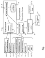
- the figure shows a preferred embodiment with a Navigation system 1 for receiving position data from a satellite-based system 10, which from the device 4 to Position determination of the navigation system are processed. Together with the position data, the navigation system receives 1 Data on the accuracy of this position data. These Data is taken from the navigation system for further processing to the device 3 for determining the reliability passed the position determination.
- the navigation device 1 receives continue to correct the positioning data, the processed by the device 4 for position determination and data on the reliability of this correction, the the navigation system to the device 3 for determining the Reliability transmitted.
- the inertial sensor 12, the steering angle sensor 14, the wheel revolution sensors 13 - together with the anti-slip regulation 17 and the anti-lock braking system 18, the lane recognition 15 and the barometer 16 provide the means 4 for positioning Signals for further correction of the position information.
- the same sensors and system supply the device 3 for determining the reliability of their reliability respective contributions to the item correction that make up the Device 3 sets a new value for the reliability of Position information calculated.
- the device 4 for position determination sends the position information to the card interface 9, the soahnd the digital map 8 performs a position matching (lane matching).
- the card interface 9 gives the corrected Position indication to the device 4 for position determination returns and sends a value for the correction of reliability to the device 3 for determining the reliability.
- the map interface from the digital map 8 according to the desired Destination continues to have a navigation hint and all necessary for a pictorial representation of the navigation reference Information and environmental information provided via a Interface of the navigation system as so-called electronic Horizon output to the image forming unit 2 become.
- the image generation unit 2 generates from the navigation notice and the electronic horizon pictorial representations of the navigation note, which points it to a projection screen 5 projected.
- Position information distinguishes the imaging unit 2 between environment-related and symbolic forms of representation.
- the environment-related representations mark thereby the perceptible on the projection surface 5 objects virtual, where it matters, the ones on the screen Vehicle-visible markings from view of the observer with the objects outside.
- This form of presentation is therefore according to the invention only for used very reliable position information, since this is the Match the real position of the vehicle with the fictitious one Position on the digital map is crucial.
- the symbolic form of presentation with low reliability the position determination is limited to fixed representations of clues on the projection screen.
- the symbolic representations Objects are assigned to the environment loosely.
- the projection screen can be, for example, a windshield be in which the navigation instructions on a Head-Up Display are mirrored.
- a head tracking system 7 which is the Image generation unit 2 Information on the position and position of the driver's head supplies.
Landscapes
- Engineering & Computer Science (AREA)
- Radar, Positioning & Navigation (AREA)
- Remote Sensing (AREA)
- Automation & Control Theory (AREA)
- Physics & Mathematics (AREA)
- General Physics & Mathematics (AREA)
- Navigation (AREA)
Abstract
Description
Die Erfindung betrifft eine Vorrichtung und ein Verfahren zur Darstellung von Fahrhinweisen zur Fahrzeugnavigation in einem Bild der Fahrzeugumgebung.The invention relates to a device and a method for Representation of driving instructions for vehicle navigation in one Picture of the vehicle environment.
Aus der DE 101 38 719 A1 ist ein Verfahren und eine Vorrichtung zur Darstellung von Fahrhinweisen im Fahrzeug bekannt, welches die von einem Navigationssystem ermittelten Fahrhinweise auf die Windschutzscheibe projiziert oder in ein von einer Video-Kamera aufgenommenes Bild der Umgebung einblendet, welches auf dem Display des Navigationssystems gezeigt wird. Die Fahrhinweise werden in Form von virtuellen Linienzügen oder Pfeilen, die aus Sicht des Fahrers bzw. der Kamera den einzuschlagenden Weg auf der Windschutzscheibe oder auf dem Display in Übereinstimmung mit der vor dem Fahrzeug liegenden Straße markieren, dargestellt. Die Ausrichtung der angezeigten Navigationshinweise im Bild der Fahrzeugumgebung wird dabei gemäß der satellitengestützten Positionsermittlung des Navigationssystems vorgenommen. Damit die Anzeige von Abzweigungen auch bei Bergauf- und Bergabfahrt aus Sicht des Fahrers bzw. der Kamera korrekt liegen, wird aus den GPS-Positionsdaten des Fahrzeugs - ggf. unterstützt durch Koppelnavigation - und der Lage des Fahrzeugs mit Hilfe eines 3D-Geländemodells eine entsprechende Verkürzung bzw. Verlängerung der Linien berechnet. DE 101 38 719 A1 discloses a method and a device for displaying driving instructions in the vehicle, which determined by a navigation system driving instructions projected onto the windshield or into one of a picture of the environment captured by a video camera, which is shown on the display of the navigation system becomes. The driving instructions are in the form of virtual Linien trains or arrows from the perspective of the driver or the camera the way to be hit on the windshield or on the display in accordance with the front of the vehicle Mark road, shown. The orientation of the displayed Navigation instructions in the image of the vehicle environment is doing according to the satellite-based position determination of the navigation system. Thus the display of branches also at uphill and downhill from the perspective of Driver or the camera are correct, is from the GPS position data of the vehicle - possibly supported by dead reckoning - and the location of the vehicle with the help of a 3D terrain model a corresponding shortening or extension of the lines.
Eine Positionsbestimmung für das Fahrzeug mit Hilfe eines satellitengestützten Systems liefert wegen unvermeidlicher Fehler Positionsangaben mit unterschiedlicher Abweichung von der realen Position des Fahrzeugs. Solche Abweichungen können durch Koppelnavigation zwar verringert werden, aber bei größeren Fehlern bezüglich der Positionsbestimmung - beispielsweise durch Reflexionen oder in Bereichen, in denen der Empfang der Satellitensignale gestört ist -, sind größere Abweichungen nicht vermeidbar, so dass umgebungsbezogene Fahrhinweise nicht genügend genau mit der Umgebung in Übereinstimmung gebracht werden können. D.h., die dem Fahrer auf der Projektionsfläche angezeigte virtuell markierte Straßenführung erscheint beispielsweise neben die eigentliche Fahrbahn versetzt; unter Umständen wird dabei sogar die Fahrbahn mit dem entgegenkommenden Verkehr markiert, oder das Bild springt hin und her. Das ist für den Fahrer zwangsläufig irritierend und lenkt dessen Aufmerksamkeit vom eigentlichen Verkehrsgeschehen ab.A positioning for the vehicle with the help of a satellite-based Systems delivers because of inevitable mistakes Position information with different deviation from the real position of the vehicle. Such deviations can may be reduced by dead reckoning, but with larger ones Errors concerning the position determination - for example through reflections or in areas where the reception the satellite signals are disturbed - are larger deviations unavoidable, so that environmental driving advice not exactly enough in line with the environment can be brought. That is, the driver on the Projection screen displayed virtual marked road appears, for example, next to the actual roadway offset; Under certain circumstances, even the roadway with marked oncoming traffic, or the image jumps back and forth. This is necessarily irritating for the driver and draws his attention from the actual traffic from.
Werden Navigationshinweise in einem Bild der Fahrzeugumgebung (das kann ein Videobild auf einem Display sein oder ein Head-Up-Display in Verbindung mit der Windschutzscheibe) beispielsweise in Form von Linien oder Pfeilen dargestellt, die sich am Straßenverlauf ausrichten, oder als Markierungen, die sich auf markante Punkte der Fahrzeugumgebung beziehen, dargestellt, ist es wichtig, dass diese Hinweise mit möglichst kontinuierlicher Präzision in das Bild der Fahrzeugumgebung eingepasst werden.Be navigation instructions in a picture of the vehicle environment (this can be a video image on a display or a head-up display in connection with the windscreen), for example represented in the form of lines or arrows, the align themselves on the road, or as markings, the refer to prominent points of the vehicle environment, shown, It is important that these notes with as possible continuous precision in the image of the vehicle environment be fitted.
Kann eine präzise Einpassung der Fahrhinweise in das Bild der Fahrumgebung wegen fehlerbehafteter Positionsangaben nicht gewährleistet werden, verrutscht die Darstellung von Fahrhinweisen im Bild gegenüber dem tatsächlich zu markierenden Bereich, wodurch die zur Orientierung gedachten Hinweise für den Fahrer nicht mehr ohne Weiteres interpretierbar sind. Abgesehen davon, dass es für den Fahrer lästig und ablenkend ist, wenn die Darstellung der Navigationshinweise gegenüber der Soll-Lage in Abhängigkeit von der Genauigkeit der Positionsbestimmung "springt", stiften inkorrekt platzierte Fahrhinweise sogar Verwirrung, wenn beispielsweise ein Abbiegehinweis im Bild der Umgebung zwischen einer näher und einer entfernter gelegenen Seitenstraße hin und her springt.Can a precise fitting of the driving instructions in the picture of the Driving environment due to faulty position information not be ensured, the presentation of driving instructions slips in the picture opposite the area actually to be marked, whereby the hints intended for orientation for the driver can not be easily interpreted. apart from being annoying and distracting to the driver is when the presentation of the navigation instructions opposite the desired position as a function of the accuracy of the position determination "jumps", incorrectly placed driving hints even confusion when, for example, a turn-off in the picture of the environment between one closer and one back side street back and forth.
Das Problem einer vom eigentlichen Objekt abweichenden Markierung kann beispielsweise durch ein Mustererkennungssystem, das für die Erkennung verschiedenster Objekte, darunter auch Straßen, ausgelegt ist, gelöst werden.The problem of a different mark from the actual object For example, by a pattern recognition system, that for the detection of various objects, including Roads, is designed to be solved.
Die WO 03 005 102 A1 beschreibt ein Head-Up Display System und ein Verfahren für eine - in Bezug auf die Sicht eines Fahrzeuginsassen ortskorrekten - Markierung von Objekten in der Fahrzeugumgebung. Die ortskorrekte oder ortsbezogene Darstellung aus der Sicht eines Fahrzeuginsassen erfolgt bezogen auf dessen durch Sensoren festgestellte Kopf- oder Augenposition. Die zu markierenden Objekte betreffen im Wesentlichen andere Verkehrsteilnehmer oder Verkehrszeichen. Die zu markierenden Objekte der Fahrzeugumgebung werden dabei mittels Kameras und Mustererkennung identifiziert und für die Markierung auf der Windschutzscheibe geeignet modelliert. Es ist auch an eine visuelle Umsetzung von Navigationsdaten gedacht, wobei dann die zu befahrende Fahrbahn bzw. eine Abzweigung für die Fahrersicht auf dem Head-Up-Display markiert wird.WO 03 005 102 A1 describes a head-up display system and a method for one - in terms of the view of one Vehicle occupants correct - Marking objects in the vehicle environment. The location-correct or location-related representation taken from the perspective of a vehicle occupant on its detected by sensors head or eye position. The objects to be marked essentially relate to other road users or traffic signs. The to be marked Objects of the vehicle environment are thereby using Cameras and pattern recognition identified and for marking modeled on the windshield suitable. It is also thought of a visual implementation of navigation data, in which case the road to be traveled or a junction is marked for the driver's view on the head-up display.
Allein mit Mitteln der Mustererkennung ist eine Abzweigung a-ber - sei es wegen vorausfahrender Fahrzeuge oder anderer, das Sichtfeld behindernder Objekte in vielen Fällen gar nicht zweifelsfrei identifizierbar, so dass die virtuelle Markierung der Abzweigung in diesen Fällen, mit den oben beschriebenen Nachteilen, wiederum von den - fehlerbehafteten - Positionsangaben des Navigationssystems abhängig ist.Only with means of pattern recognition is a branch a-over whether because of vehicles in front or others, the field of view of obstructing objects in many cases not at all unambiguously identifiable, so that the virtual mark the diversion in these cases, with those described above Disadvantages, again of the - faulty - position information depends on the navigation system.
Aufgabe der Erfindung ist es, eine Vorrichtung und ein Verfahren mit einer stets zuverlässig interpretierbaren Darstellung von Navigationshinweisen in einem Bild der Fahrumgebung zu schaffen.The object of the invention is an apparatus and a method with an always reliably interpretable representation of navigation hints in a picture of the driving environment to accomplish.
Die Aufgabe wird durch die Merkmale der unabhängigen Ansprüche
1 und 9 gelöst. Vorteilhafte Ausgestaltungen ergeben sich
durch die Unteransprüche.The object is achieved by the features of the
Das erfindungsgemäße Verfahren macht die Darstellung der vom Navigationssystem ermittelten Navigationshinweise von der Zuverlässigkeit der von einem satellitengestützen System ermittelten Positionsangabe für das Fahrzeug abhängig. Durch die Berücksichtigung der Zuverlässigkeit oder Genauigkeit der Positionsangaben kann die Darstellung der Navigationshinweise immer in einer für den Fahrer bestmöglich erfassbaren Form gewährleistet werden. Die erfindungsgemäße Bilderzeugungseinheit erzeugt den vom Navigationssystem ermittelten Navigationshinweis also stets in einer Darstellungsform, die gemäß der für die Positionsangabe erreichbaren Zuverlässigkeit für den Fahrer am besten erfassbar ist und die geringste Ablenkung mit sich bringt.The inventive method makes the representation of the Navigation system determined navigation instructions of the reliability that determined by a satellite-based system Position indication for the vehicle dependent. By the Consider the reliability or accuracy of the position information can be the presentation of navigation instructions always in the best possible form for the driver be guaranteed. The image generation unit according to the invention generates the navigation hint determined by the navigation system So always in a form of representation, according to the reliability achievable for the position indication for the driver is best recorded and the least distraction brings with it.
Ein Navigations- oder Fahrhinweis kann von der Bilderzeugungseinheit bei hochgenauen Positionsangaben beispielsweise für den Fahrer komfortabel als virtuelle, dem Straßenverlauf folgende Linienführung erzeugt und präziese in ein Bild der Fahrzeugumgebung auf einer Projektionsfläche im Fahrzeug eingeblendet werden. Ist die Zuverlässigkeit der Positionsangaben für eine zufriedenstellende Darstellung von Fahrhinweisen mit direktem Bezug zur Umgebung jedoch zu gering, schaltet die Bilderzeugungseinheit auf andere Darstellungsformen um, beispielsweise auf schematische Pfeile oder virtuelle Verkehrszeichen, von denen der Fahrer nicht erwartet, dass sie sich optisch an die sich verändernde Umgebung anpassen. Schematisch oder abstrakt dargestellte Navigationshinweise werden auf einem festen Platz auf der Projektionsfläche angezeigt oder ein Bezug des Fahrhinweises zur Umgebung wird stark gedämpft nachgeführt. Die bei abstrakteren Darstellungsformen gegenüber Darstellungen mit Umgebungsbezug eingebüßte Aussagekraft des dargestellten Hinweises kann beispielsweise durch unterstützende akustische Hinweise ausgeglichen werden.A navigation or driving advice may be provided by the imaging unit for example, with highly accurate position information comfortable for the driver as virtual, the road creates the following lines and precise in a picture of Vehicle environment displayed on a projection screen in the vehicle become. Is the reliability of the position information for a satisfactory presentation of driving instructions with direct reference to the environment but too low, switches convert the image generation unit to other forms of representation, for example, on schematic arrows or virtual traffic signs, from which the driver does not expect them optically adapt to the changing environment. schematically or abstract navigation information displayed on a fixed space on the screen or A reference of the driving instruction to the environment is strongly damped tracked. The more abstract forms of representation Significance lost in comparison to representations relating to the environment the hint shown, for example, by supporting acoustic hints are compensated.
Die Bestimmung der Zuverlässigkeit für die durch das satellitengestützte System ermittelte Positionsangabe erfolgt vorteilhaft durch eine Erfassung und Auswertung der statistischen Werte, welche satellitengestützte Systeme üblicherweise zur Genauigkeit der ermittelten Position mit angeben. Diese Werte werden vom Navigationssystem bei der Positionsbestimmung mit empfangen, und von diesem an die Einrichtung zur Bestimmung der Zuverlässigkeit weitergegeben. Die Zuverlässigkeit selbst kann als statistisches Maß in verschiedenen Größen, beispielsweise als Standardabweichung oder eine Fehlerwahrscheinlichkeit ausgedrückt werden.The determination of reliability for those by the satellite System determined position information is advantageous through a collection and evaluation of the statistical Values which satellite systems usually to indicate the accuracy of the determined position. These Values are used by the navigation system when determining the position with, and from this to the device for the determination Reliability passed. The reliability itself can be used as a statistical measure in various sizes, for example as a standard deviation or an error probability be expressed.
Die Positionsangabe wird vorteilhaft durch Korrekturdaten einer Bodenstation präzisiert, wobei auch die Zuverlässigkeit mit Werten für die Zuverlässigkeit dieser Präzisierung korrigiert wird. Dabei erhält die Einrichtung zur Ermittlung der Positionsangabe die Daten zur Korrektur der Position durch das Navigationssystem, welches diese Daten und auch die Daten zur Zuverlässigkeit dieser Positionskorrektur von der Bodenstation empfängt, und die Daten zur Korrektur der Zuverlässigkeit an die Einrichtung zur Bestimmung der Zuverlässigkeit übermittelt. In die Korrektur der Zuverlässigkeitsbestimmung kann dabei auch der Korrekturbetrag, um den die Positionsangabe verbessert wurde, eingehen. Diesen Differenzbetrag erhält das Navigationssystem von der Einrichtung zur Ermittlung der Positionsangabe.The position indication is advantageous by correction data of a Ground station specified, while also the reliability corrected with values for the reliability of this specification becomes. In this case, the device for determining the Position indication the data for correcting the position by the navigation system, which this data and also the data on the reliability of this position correction from the ground station receives, and the data to correct the reliability to the device for determining reliability transmitted. In the correction of the reliability determination can also be the amount of correction to the position was improved. Receives this difference the navigation system of the device for the determination the position information.
Durch Positionskorrekturen, wie sie für satellitengestützte Navigationssysteme durch Empfang von Signalen von fest vermessenen Bodenstationen, beispielsweise durch differentielles GPS möglich sind, kann die Genauigkeit der Positionsangaben vorteilhaft um mehrere Meter verbessert werden. Dies hilft in Bereichen, in denen der Empfang solcher Stationen möglich ist, die Position eines Fahrzeugs mit einer hohen Zuverlässigkeit zu bestimmen. In solchen Bereichen kann das erfindungsgemäße System objektbezogene Navigationshinweise auf der Projektionsfläche in ausreichender Übereinstimmung mit den Objekten der Fahrzeugumgebung darstellen. Die Positionsangaben für das Fahrzeug können noch weiter verbessert werden, indem die ermittelte Position mit einer digitalen Karte abgeglichen wird (Lane-Matching). Auch ein solcher Positionsabgleich führt wiederum zu einer erhöhten Zuverlässigkeit für die Positionsangabe, wobei die Verbesserung umso größer wird, je genauer die digitale Karte ist.By position corrections, as for satellite Navigation systems by receiving signals from permanently measured Ground stations, for example, by differential GPS are possible, the accuracy of the position information advantageous to be improved by several meters. This helps in Areas where the reception of such stations possible is the position of a vehicle with a high reliability to determine. In such areas, the inventive System object - related navigation instructions on the Projection surface in sufficient accordance with the Represent objects of the vehicle environment. The position information for the vehicle can be further improved by comparing the determined position with a digital map becomes (lane-matching). Also such a position adjustment in turn leads to increased reliability for the position indication, whereby the improvement becomes greater, the more accurate the digital map is.
Es ist weiterhin von Vorteil, wenn die Positionsangabe durch fahrzeugseitig erhobene Signale präzisiert wird, wobei die Zuverlässigkeit entsprechend mit Werten für die Zuverlässigkeit dieser Präzisierungen korrigiert wird. Dazu sind die fahrzeugseitigen Sensoren mit der Einrichtung zur Ermittlung der Positionsangabe verbunden, die von den Sensoren die Daten zur Korrektur der Positionsangabe empfängt. Die Einrichtung zur Bestimmung der Zuverlässigkeit empfängt von den Fahrzeug-Sensoren Daten zur entsprechenden Korrektur der Zuverlässigkeit. Diese Daten betreffen die Zuverlässigkeit der Sensoren bzw. ihrer Messungen.It is also advantageous if the position information by vehicle-level signals is specified, the Reliability accordingly with values for the reliability this clarification is corrected. These are the vehicle-mounted sensors with the device for determination the position information connected by the sensors the data to correct the position information receives. The device for determining the reliability receives from the vehicle sensors Data for the corresponding correction of reliability. These data relate to the reliability of the sensors or their measurements.
Der Vorteil von Positionskorrekturen mit Hilfe fahrzeugseitiger Sensoren besteht vor allem darin, dass hiermit ein gestörter Empfang der für die Positionsbestimmung notwendigen Satelliten-Signale überbrückt oder ausgeglichen werden kann. In Städten können die Satelliten-Signale durch hohe und dichte Bebauung reflektiert oder in Wäldern durch dichtes Blattwerk stellenweise verschattet werden, so dass die Position für eine Darstellung von Fahrhinweisen, die mit Bezug zur realen Umgebung dargestellt werden sollen, nicht mehr ausreichend genau bestimmt werden kann. Bei einem Empfang von weniger als 4 Satelliten oder durch Mehrwege-Effekte ergeben sich größere Differenzen zwischen der tatsächlichen und der berechneten Position eines Fahrzeugs. Mehrwege-Effekte können beispielsweise auch durch eine zweite Antenne zum Empfang von Satelliten-Positionsdaten am Fahrzeug, mit möglichst großer Entfernung zur ersten Antenne, durch Differenzberechnungen korrigiert werden.The advantage of position corrections with the help of the vehicle Sensors consists mainly in that hereby a disturbed Reception of the necessary for the position determination Satellite signals can be bridged or compensated. In cities, the satellite signals can be high and dense Buildings reflected or in forests by dense foliage be shaded in places, leaving the position for a presentation of driving instructions related to the real Environment are no longer sufficient can be determined exactly. At a reception of less as 4 satellites or through multipath effects arise greater differences between the actual and the calculated Position of a vehicle. Multipath effects can for example, by a second antenna for the reception of Satellite position data on the vehicle, with the largest possible Distance to the first antenna, by difference calculations Getting corrected.
Vorteilhafte Methoden zur Ergänzung und Korrektur der absoluten Positionsdaten, wie sie vom satellitengestützten System oder von einer Bodenstation empfangen werden, mit relativen Positionsangaben sind Odometrie und Koppelnavigation, die mit Angaben zu Lenkwinkel und Radumdrehung bzw. Beschleunigung o-perieren. Diese Signale werden von einem Lenkwinkelsensor und Radumdrehungssensoren und/oder von einem Inertialsensor erzeugt. Auch Informationen von der Anti-Schlupf-Regelung oder vom Anti-Blockiersystem sind zur genaueren Auswertung der Radumdrehung nutzbar. Signale für die relative Höhenänderung liefert ein Barometer. Advantageous methods to complement and correct the absolute Location data, as provided by the satellite-based system or received from a ground station, with relative Position information is odometry and dead reckoning with Information on steering angle and wheel revolution or acceleration o-perieren. These signals are from a steering angle sensor and Radumdrehungssensoren and / or generated by an inertial sensor. Also information from the anti-slip regulation or from the anti-lock system are for more accurate evaluation of Wheel rotation usable. Signals for relative altitude change delivers a barometer.
Eine besonders vorteilhafte Möglichkeit zur relativen Präzisierung der Positionsangabe besteht im Einsatz einer videogestützten Fahrspurerkennung, deren Resultat eine Korrektur der Positionsangabe in lateraler Richtung erlaubt. Mit Nachtsichtgeräten ist dies auch nachts zuverlässig möglich. Eine Präzisierung der Positionsangaben in lateraler Richtung ist gerade für eine Darstellung von Navigationshinweisen als virtuelle Fahrbahnmarkierungen von besonderer Bedeutung, damit die virtuelle Markierung nicht versehentlich eine benachbarte Fahrbahn oder gar die Gegenfahrbahn anzeigt.A particularly advantageous possibility for relative precision the position indication consists in the employment of a video-supported Lane detection, the result of which is a correction of the Position indication in lateral direction allowed. With night vision devices This is reliably possible even at night. A Precision of the position information in the lateral direction is just for a presentation of navigation hints as virtual Road markings of particular importance to it the virtual marker will not accidentally be an adjacent one Lane or even the opposite lane displays.
Zu den Daten, die diese Sensoren zur Positionskorrektur liefern, sind Daten zur Zuverlässigkeit der Messungen bestimmbar. Das können beispielsweise Herstellerangaben zu den Sensoren sein, zeit- oder entfernungsabhängig gewichtete Größen oder - im Fall des videogestützten Erkennungssystems - Werte für die Erkennungssicherheit.The data that these position correction sensors provide Data on the reliability of the measurements can be determined. For example, manufacturer information about the sensors be, time- or distance-dependent weighted sizes or, in the case of the video-based recognition system, values for the recognition security.
Unter Ausnutzung der erwähnten Mittel können so präzise Positionsangaben erreicht werden, dass in Bereichen, in denen beispielsweise mindestens 7 Satelliten empfangen werden können, virtuelle Fahrbahnmarkierungen über längere Strecken angezeigt werden können. Bei dieser Darstellungsweise können mit der virtuellen Markierung der Fahrbahn auch Geschwindigkeitsangaben bzw. einzuleitende Bremsvorgänge, beispielsweise vor Kurven, angezeigt werden, indem die Markierung für bestimmte Geschwindigkeitsbereiche unterschiedlich gefärbt ist, oder indem neben der Markierung explizite Geschwindigkeitsangaben angezeigt werden.Taking advantage of the mentioned means so precise position information be achieved in areas where For example, at least 7 satellites can be received, virtual lane markings displayed over longer distances can be. In this way of representation can with the virtual marking of the roadway also speed indications or to be initiated braking operations, for example before curves, be displayed by marking for certain Speed ranges is colored differently, or by adding explicit speed information next to the marker are displayed.
Aber trotz der zusätzlicher Backup-Methoden, wie sie soeben beschrieben wurden, kann die Fahrzeugposition nur begrenzte Zeit mit ausreichender Zuverlässigkeit verfolgt werden. Mit zunehmender Entfernung vom letzten absolut bzw. satellitengestützt erfassten Messpunkt wächst auch bei diesen relativen Methoden der Fehler. Sind auf Dauer nicht ausreichend viele Satelliten für eine zuverlässige Positionsbestimmung erreichbar oder stören Mehrwege-Effekte die Positionsbestimmung und ist auch keine Bodenstation für den Empfang von Korrekturdaten erreichbar sinkt die Zuverlässigkeit der Positionsbestimmung, so dass von der Bilderzeugungseinrichtung für die Darstellung der virtuellen Fahrhinweise kein sicherer Umgebungsbezug herstellbar ist.But despite the additional backup methods, like them just now described vehicle position can be limited Time to be tracked with sufficient reliability. With increasing distance from the last absolute or satellite-based recorded measuring point also grows at these relative Methods of error. Are not enough in the long run Satellites available for reliable positioning or multipath effects disturb the positioning and is also not a ground station for receiving correction data achievable decreases the reliability of the position determination, so that from the imaging device for the representation the virtual driving instructions no safe environmental reference can be produced.
Daher ist es vorteilhaft, die zuverlässigkeitsabhängige Darstellung der Navigationshinweise gemäß drei Zuverlässigkeitsstufen vorzunehmen. Die erfindungsgemäße Bilderzeugungseinheit erzeugt die Navigationshinweise demnach bei einer hohen Zuverlässigkeit in einer umgebungsbezogen Darstellung, bei einer geringen Zuverlässigkeit in einer symbolischen Darstellung und bei einer mittleren Zuverlässigkeit - abhängig vom darzustellenden Navigationshinweis - entweder in umgebungsbezogener oder symbolischer Darstellung.Therefore, it is advantageous, the reliability-dependent representation the navigation instructions according to three levels of confidence make. The image generation unit according to the invention generates the navigation instructions accordingly at a high Reliability in an environmental representation, at a low reliability in a symbolic representation and at a medium reliability - depending on navigation note to be displayed - either in environment-related or symbolic representation.
Eine dreistufige Unterscheidung von Darstellungsformen für Navigationshinweise trägt der Erfordernis einer für den Fahrer ablenkungsfreien Präsentation der Navigationshinweise ausreichend Rechnung. Kann ein ausreichend genauer Umgebungsbezug für nicht hergestellt werden, weil die Positionsabweichungen in lateraler Richtung beispielsweise auf Dauer größer als ein halber oder als ein Meter werden, erfolgt die Darstellung der Fahrhinweise symbolisch, beispielsweise im Fall einer Abzweigung als ein abknickender Pfeil, der seine Lage auf der Projektionsfläche nicht verändert, aber ggf. mit der Annäherung an den Navigationspunkt wächst. Anstatt schematisierter Pfeile können hierbei auch virtuelle Wegweiser oder Verkehrszeichen dargestellt werden. A three-stage distinction of forms of representation for Navigation instructions carries the requirement of one for the driver distraction-free presentation of the navigation instructions sufficient bill. Can be a sufficiently accurate environmental reference for not being manufactured because the positional deviations in the lateral direction, for example, permanently larger as a half or as a meter, the representation takes place the driving instructions symbolic, for example in the case a turn off as a kinking arrow that changes its location on the projection screen not changed, but if necessary with the Approaching the navigation point is growing. Instead of schematized Arrows can also be virtual signposts or Traffic signs are displayed.
Wenn die Genauigkeit für die Positionsbestimmung in einem mittleren Bereich - beispielsweise in einem Bereich zwischen einem und fünf Metern liegt -, kann diese symbolische Darstellung auf der Projektionsfläche unter Zugrundelegung stark gedämpfter Positionsangaben langsam an den Navigationspunkt angenähert werden.If the accuracy for positioning in a middle range - for example, in a range between one and five meters lies - can this symbolic representation on the projection screen based on strong damped position information slowly to the navigation point be approximated.
In longitudinaler Richtung kann man die Anforderungen an die Zuverlässigkeit oder Genauigkeit der Positionsbestimmung anders als in lateraler Richtung einteilen. Beispielsweise kann in Längsrichtung ein Bereich bis zu 3 oder 4 Metern als hoch zuverlässig, und ein Bereich zwischen 4 und 12 Metern als mittel zuverlässig gewertet werden. Die Zuverlässigkeit von Höhenangaben ist im Wesentlichen nur dann von Interesse, wenn ausreichend genaue Karten auch für Höhenangaben vorliegen. Ansonsten braucht die vertikale Dimension nicht ausgewertet zu werden, oder es genügt eine relative grobe Einteilung für gelegentliche Abgleiche.In the longitudinal direction one can meet the requirements of the Reliability or accuracy of positioning differently as dividing in a lateral direction. For example, can in the longitudinal direction an area up to 3 or 4 meters as high reliable, and an area between 4 and 12 meters as be reliably evaluated. The reliability of Height information is essentially only of interest if sufficiently accurate maps are also available for altitude information. Otherwise, the vertical dimension does not need to be evaluated or a relatively rough classification is sufficient for occasional matches.
Die Umschaltung zwischen den unterschiedlichen Darstellungsformen erfolgt jeweils erst dann, wenn die Zuverlässigkeit für einen gewissen Zeitraum in dem entsprechenden Zuverlässigkeitsbereich liegt. Der Zeitraum für Einhaltung einer hohen Zuverlässigkeit zur Umschaltung in die umgebungsbezogene Darstellung ist dabei sicherheitshalber länger zu wählen, als der Zeitraum für eine mittlere oder geringe Zuverlässigkeit zur Umschaltung in eine symbolische Darstellungsform der Navigationshinweise.Switching between the different forms of representation takes place only when the reliability for a certain period of time in the appropriate reliability range lies. The period for adherence to a high Reliability for switching to the environment-related To be on the safe side, the presentation should be made longer than the period for medium or low reliability for switching to a symbolic representation of the navigation instructions.
Für die umgebungsbezogene Darstellung werden die Navigationshinweise vorteilhaft lagerichtig zur Sicht des Fahrers oder zum Blickwinkel einer Kamera auf geeignete Objekte im Bild der Fahrzeugumgebung projiziert. For the environment-related presentation, the navigation instructions advantageous in the correct position for the driver or view to the perspective of a camera on suitable objects in the picture projected in the vehicle environment.
Die Projektionsfläche ist kann dabei entweder
- ein Display sein, auf dem das durch eine Kamera aufgenommene Bild der Fahrzeugumgebung wiedergegeben wird, in welches die durch die Bilderzeugungseinheit erzeugten Darstellungen der Navigationshinweise eingeblendet werden, oder
- eine halbdurchlässige Datenbrille oder
- die Windschutzscheibe in Verbindung mit einem Head-Up-Display sein, in welche die durch die Bilderzeugungseinheit erzeugten Navigationshinweise einblendbar sind.
- a display on which the captured image of the vehicle environment is reproduced by a camera, in which the images generated by the image generating unit representations of the navigation instructions are displayed, or
- a semipermeable data glasses or
- the windscreen in conjunction with a head-up display, in which the navigation instructions generated by the image generating unit can be displayed.
Die lagerichtige Darstellung der umgebungsbezogenen Navigationshinweise wird dabei im Falle der Kombination von Display und Kamera vorteilhaft durch Bestimmung der relativen Lage der Kamera zur Umgebung mittels des vorhandenen Inertialsensors gewährleistet. Mit der Information über die bekannte Position der Kamera zusammen mit der Lageinformation des Inertialsensors und der zum Navigationshinweis gehörenden Karteninformation (elektronischer Horizont) kann die Bilderzeugungseinheit den richtigen Ort für eine virtuelle Markierung von Objekten der Fahrzeugumgebung, die für die Navigationshinweise markiert werden sollen, bestimmen und auf der Projektionsfläche lagerichtig in das Bild projizieren.The correct position of the environment-related navigation hints is doing in the case of the combination of display and camera advantageous by determining the relative position the camera to the environment using the existing inertial sensor guaranteed. With the information about the known position the camera together with the position information of the inertial sensor and the map information associated with the navigation hint (electronic horizon) can be the image generation unit the right place for a virtual marker of objects of the vehicle environment necessary for the navigation instructions be marked, determine and on the projection screen projecting correctly in the image.
Eine lagerichtige Darstellung der umgebungsbezogenen Navigationshinweise mittels eines Head-Up-Display oder mittels einer halbdurchlässigen Datenbrille wird vorteilhaft entsprechend den zum Display gemachten Ausführungen durch Bestimmung von Position und Lage des Fahrerkopfes relativ zur Umgebung mittels eines Head-Tracking-Systems erreicht.A correct representation of the environmental navigation information by means of a head-up display or by means of a semi-transparent data glasses will be advantageous accordingly the statements made on the display by determination of position and position of the driver's head relative to the environment achieved by means of a head-tracking system.
Damit ist Projektion der virtuellen Fahrhinweise besonders genau nach der Sicht des Fahrers auf die Umgebung ausgerichtet. Es werden aber auch gute Resultate erzielt, wenn die Bilderzeugung mit einer geschätzen, fixen Position für den Fahrerkopf arbeitet.This makes projection of the virtual driving information special exactly in line with the driver's view of the surroundings. But also good results are achieved if the Image production with an estimated, fixed position for the Driver's head works.
Bei der umgebungsbezogenen Darstellung von Navigationshinweisen werden Objekte der Fahrzeugumgebung möglichst lagerichtig zu einem bestimmten Betrachtungswinkel - sei des der der Kamera oder der des Fahrers - virtuell mittels einer Projektionsfläche markiert. Also Objekte kommen dabei nicht nur Straßenverläufe in Frage, es ist auch denkbar, die Navigation an Gebäuden auszurichten oder Hinweise zu markanten Punkten oder speziellen Points of Interest (POI) zu geben. Letztere können beispielsweise speziell für den Beifahrer mit interessanten Informationen konnotiert werden. Die optische Bezugnahme auf diese Objekte erfolgt ebenso in einer Darstellung, die der Zuverlässigkeit der Positionsbestimmung Rechnung trägt.In the environment-related presentation of navigation instructions, objects of the vehicle environment are as correctly positioned as possible at a specific viewing angle - be that of the camera or the driver - virtually marked by means of a projection screen. So objects are not only road courses in question, it is also conceivable to align the navigation of buildings or to give advice on distinctive points or special points of interest (POI). The latter, for example, can be connoted with interesting information for the passenger in particular. The optical reference to these objects also takes place in a representation that takes into account the reliability of the position determination.
Weitere Navigationshinweise betreffen beispielsweise Baustellen, Unfälle, Umleitungen oder Staus. Diese Informationen werden, wie die übrigen Umgebungsinformationen, der digitalen Karte entnommen, welche regelmäßig über eine Kommunikationsverbindung zu einer Dienstezentrale um diese Informationen aktualisiert und ergänzt wird.Further navigation instructions relate, for example, to construction sites, Accidents, detours or traffic jams. This information be like the rest of the environment information, the digital Card taken, which regularly via a communication link to a service center for this information is updated and supplemented.
Für eine möglichst gut interpretierbare Darstellung von Navigationshinweisen ist es von Nutzen, bestimmte Informationen, die das Navigationssystem hat, nicht anzuzeigen, um den Fahrer nicht abzulenken oder zu verwirren. Dazu gehören beispielsweise Streckenverläufe, die vom Fahrer nicht einsehbar sind, wie beispielsweise Kurven oder Tunnel oder Unterführungen. Deshalb ist es vorteilhaft, wenn das Bilderzeugungssystem Navigationshinweise, die sich auf - aus Sicht des Fahrers oder der Kamera - verdeckte Objekte beziehen, nicht - oder unterscheidbar anders, als Navigationshinweise die sich auf sichtbare Objekte beziehen - dargestellt werden. Dies kann vorteilhaft gewährleistet werden, wenn die Bilderzeugungseinheit vom Navigationssystem Informationen zur Unterscheidung von Objekten, die aus Sicht des Fahrers oder der Kamera verdeckt sind, von Objekten, die sichtbar sind, erhält.For the most accurate interpretation of navigation instructions is it useful to provide certain information, which has the navigation system, not to indicate to the driver not to distract or confuse. These include, for example Routes that are not visible to the driver such as curves or tunnels or underpasses. Therefore, it is advantageous if the imaging system Navigation instructions that are on - from the perspective of the driver or the camera - refer to hidden objects, not - or distinctively different, as navigation hints are based on Obtain visible objects. This can be ensured advantageous when the image forming unit from the navigation system Information to the distinction objects obscured from the perspective of the driver or the camera are, of objects that are visible, receives.
Die verdeckten oder nicht einsehbaren Objekte können dann entweder ganz von der Darstellung ausgenommen werden, oder sie können beispielsweise strichliert oder in blasserer Schattierung angezeigt werden. Es können neben den Informationen auch der digitalen Karte auch weitere Informationen zur Ausblendung verdeckter Objekte herangezogen werden. Mit einem Distronic-Sensor kann beispielsweise der Abstand zu einem vorausfahrenden Fahrzeug berechnet werden, so dass eine virtuelle Fahrbahnmarkierung dann beispielsweise nur bis zu diesem Fahrzeug angezeigt wird.The hidden or non-visible objects can then either completely excluded from the presentation, or For example, they can be dashed or paler Shading will be displayed. It can be next to the information also the digital map also more information about Suppression of hidden objects are used. With a Distronic sensor can, for example, the distance to a be calculated ahead of the vehicle, so that a virtual Road marking then, for example, only up to this Vehicle is displayed.
Die Erfindung wird nun anhand der Figur näher erläutert:The invention will now be explained in more detail with reference to the figure:
Die Figur zeigt ein bevorzugtes Ausführungsbeispiel mit einem
Navigationssystem 1 zum Empfang von Positionsdaten von einem
satellitengestützten System 10, die von der Einrichtung 4 zur
Positionsbestimmung des Navigationssystems verarbeitet werden.
Zusammen mit den Positionsdaten empfängt das Navigationssystem
1 Daten zur Genauigkeit dieser Positionsdaten. Diese
Daten werden vom Navigationssystem zur weiteren Verarbeitung
an die Einrichtung 3 zur Bestimmung der Zuverlässigkeit
der Positionsbestimmung durchgereicht.The figure shows a preferred embodiment with a
Von der Bodenstation 11 empfängt die Navigationseinrichtung 1
weiterhin Daten zur Korrektur der Positionsbestimmung, die
von der Einrichtung 4 zur Positionsbestimmung verarbeitet
werden, und Daten zur Zuverlässigkeit dieser Korrektur, die
das Navigationssystem an die Einrichtung 3 zur Bestimmung der
Zuverlässigkeit übermittelt.From the
Der Inertialsensor 12, der Lenkwinkelsensor 14, die Radumdrehungssensoren
13 - zusammen mit der Anti-Schlupf-Regelung 17
und dem Anti-Blockiersystem 18 -, die Fahrspur-Erkennung 15
und das Barometer 16 liefern der Einrichtung 4 zur Positionsbestimmung
Signale zur weiteren Korrektur der Positionsangabe.
Die gleichen Sensoren und System liefern der Einrichtung
3 zur Bestimmung der Zuverlässigkeit zur Zuverlässigkeit ihrer
jeweiligen Beiträge zur Positionskorrektur, aus denen die
Einrichtung 3 einen neuen Wert für die Zuverlässigkeit der
Positionsangabe errechnet.The
Die Einrichtung 4 zur Positionsbestimmung sendet die Positionsangabe
an die Karten-Schnittstelle 9, die damit anahnd der
digitalen Landkarte 8 einen Positionsabgleich durchführt (Lane-Matching).
Die Karten-Schnittstelle 9 gibt die korrigierte
Positionsangabe an die Einrichtung 4 zur Positionsbestimmung
zurück und sendet einen Wert für die Korrektur der Zuverlässigkeit
an die Einrichtung 3 zur Bestimmung der Zuverlässigkeit.The
Mit der korrigierten Positionsangabe erzeugt die Karten-Schnittstelle
aus der digitalen Landkarte 8 gemäß dem gewünschten
Zielort weiterhin einen Navigationshinweis und alle
für eine bildliche Darstellung des Navigationshinweises notwendigen
Angaben und Umgebungsinformationen, die über eine
Schnittstelle des Navigationssystems als sogenannter elektronischer
Horizont an die Bilderzeugungseinheit 2 ausgegeben
werden.With the corrected position indication generated the map interface
from the
Die Bilderzeugungseinheit 2 erzeugt aus dem Navigationshinweis
und dem elektronischen Horizont bildliche Darstellungen
des Navigationshinweises, die sie auf eine Projektionsfläche
5 projiziert. Abhängig von der Zuverlässigkeit der ermittelten
Positionsangaben unterscheidet die Bilderzeugungseinheit
2 zwischen umgebungsbezogenen und symbolischen Darstellungsformen.
Die umgebungsbezogenen Darstellungen markieren dabei
die auf der Projektionsfläche 5 wahrnehmbaren Objekte virtuell,
wobei es darauf ankommt, das sich die auf die Projektionsfläche
im Fahrzeug eingeblendeten Markierungen aus Sicht
des Betrachters mit den draußen befindlichen Objekte treffen.
Diese Darstellungsform wird daher erfindungsgemäß nur für
sehr zuverlässige Positionsangaben eingesetzt, da hierfür die
Übereinstimmung der realen Position des Fahrzeug mit der fiktiven
Position auf der digitalen Karte entscheidend ist.The
Die symbolische Darstellungsform bei geringer Zuverlässigkeit der Positionsbestimmung beschränkt sich auf ortsfeste Darstellungen von Hinweisen auf der Projektionsfläche. Bei einigermaßen ausreichender Genauigkeit der Positionsbestimmung und Eignung des Fahrhinweises können die symbolischen Darstellungen Objekten der Umgebung lose zugeordnet werden.The symbolic form of presentation with low reliability the position determination is limited to fixed representations of clues on the projection screen. In reasonably sufficient accuracy of the position determination and suitability of the driving instruction, the symbolic representations Objects are assigned to the environment loosely.
Die Projektionsfläche kann beispielsweise eine Windschutzscheibe
sein, in welche die Navigationshinweise über ein
Head-Up-Display eingespiegelt werden. Für eine genaue, lagerichtige
Projektion dient ein Head-Tracking-System 7, das der
Bilderzeugungseinheit 2 Angaben zu Position und Lage des Fahrerkopfes
liefert.The projection screen can be, for example, a windshield
be in which the navigation instructions on a
Head-Up Display are mirrored. For a precise, correct position
Projection is a head tracking system 7, which is the
Claims (19)
dadurch gekennzeichnet, dass eine Zuverlässigkeit für die Positionsangabe ermittelt wird, und die Bilderzeugungseinheit (2) die Navigationshinweise zuverlässigkeitsabhängig in unterschiedlicher Darstellung erzeugt.Method for displaying navigation instructions on a projection surface (5) in a vehicle, comprising a navigation system (1) which continuously determines position information for the vehicle by means of a satellite-supported system (10) and which is determined by the navigation system (1) by means of an image generation unit (2) ) generated navigation instructions and in an image of the vehicle environment on the projection screen (5),
characterized in that a reliability for the position information is determined, and the image generating unit (2) generates the navigation instructions depend on reliability in different representation.
dadurch gekennzeichnet, dass die Zuverlässigkeit aus statistischen Werten, die das satellitengestützte System (10) zur Genauigkeit der ermittelten Position angibt, bestimmt wird.Method according to claim 1,
characterized in that the reliability is determined from statistical values given by the satellite based system (10) for the accuracy of the detected position.
dadurch gekennzeichnet, dass die Positionsangabe durch Korrekturdaten einer Bodenstation (11) präzisiert wird, und die Zuverlässigkeit mit Werten für die Zuverlässigkeit dieser Präzisierungen korrigiert wird.Method according to one of claims 1 or 2,
characterized in that the position information is specified by correction data of a ground station (11), and the reliability is corrected with values for the reliability of these specifications.
dadurch gekennzeichnet, dass die Positionsangabe durch fahrzeugseitig erhobene Signale präzisiert wird, und die Zuverlässigkeit mit Werten für die Zuverlässigkeit dieser Präzisierungen korrigiert wird.Method according to one of claims 1 to 3,
characterized in that the position information is specified by signals raised on the vehicle side, and the reliability is corrected with values for the reliability of these specifications.
dadurch gekennzeichnet, dass als fahrzeugseitig erhobene Signale Beschleunigung und/oder eine relative Höhenänderung und/oder das Resultat einer Fahrspurerkennung verwendet werden.Method according to claim 4,
characterized in that used as vehicle-mounted signals acceleration and / or a relative change in altitude and / or the result of a lane detection are used.
dadurch gekennzeichnet, dass die Bilderzeugungseinheit (2) die zuverlässigkeitsabhängige Darstellung der Navigationshinweise
characterized in that the image generation unit (2) the reliability-dependent representation of the navigation instructions
dadurch gekennzeichnet, dass bei der umgebungsbezogenen Darstellung die Navigationshinweise lagerichtig zur Sicht des Fahrers oder zum Blickwinkel einer Kamera (6) auf geeignete Objekte im Bild der Fahrzeugumgebung projiziert werden. Method according to claim 6,
characterized in that in the environment-related representation, the navigation instructions are projected in the correct position for the driver's view or the viewing angle of a camera (6) to suitable objects in the image of the vehicle environment.
dadurch gekennzeichnet, dass Navigationshinweise, die sich auf - aus Sicht des Fahrers oder der Kamera (6) - verdeckte Objekte beziehen, nicht - oder unterscheidbar anders, als Navigationshinweise, die sich auf sichtbare Objekte beziehen - dargestellt werden.Method according to one of claims 6 or 7,
characterized in that navigation instructions relating to - from the perspective of the driver or the camera (6) - hidden objects, not - or distinguishable differently, as navigation instructions that relate to visible objects - are displayed.
dadurch gekennzeichnet, dass eine Einrichtung zur Bestimmung der Zuverlässigkeit der Positionsangabe (3) vorhanden ist, die mit der Bilderzeugungseinheit (2) zur zuverlässigkeitsabhängigen Erzeugung unterschiedlicher Darstellungen für die Navigationshinweise verbunden ist.Device for displaying navigation instructions on a projection surface (5) in a vehicle, comprising a navigation system (1) for continuously determining a position indication for the vehicle by means of a satellite-based system (10) and an image generation unit (2) for generating the navigation instructions determined by the navigation system and Representation in an image of the vehicle surroundings on the projection surface (5),
characterized in that there is a device for determining the reliability of the position information (3), which is connected to the image generation unit (2) for the reliability-dependent generation of different representations for the navigation instructions.
dadurch gekennzeichnet, dass die Einrichtung zur Bestimmung der Zuverlässigkeit (3) über das Navigationssystem mit dem satellitengestützten System (10) zum Empfang von Daten, die Genauigkeit der Positionsangabe betreffend, in Kommunikationsverbindung steht. Device according to claim 9,
characterized in that the device for determining the reliability (3) via the navigation system with the satellite-based system (10) for receiving data relating to the accuracy of the position indication, in communication.
dadurch gekennzeichnet, dass eine Bodenstation (11) mit der Einrichtung zur Ermittlung der Positionsangabe (4) zum Empfang von Daten zur Korrektur der Positionsangabe und über das Navigationssystem mit der Einrichtung zur Bestimmung der Zuverlässigkeit (3) zum Empfang von Daten zur Korrektur der Zuverlässigkeit in Kommunikationsverbindung steht.Device according to one of claims 9 or 10,
characterized in that a ground station (11) comprises means for determining the position indication (4) for receiving data for correcting the position indication and the navigation system having means for determining the reliability (3) for receiving data for correcting the reliability in Communication connection is.
dadurch gekennzeichnet, dass fahrzeugseitige Sensoren mit der Einrichtung zur Ermittlung der Positionsangabe (4) zum Empfang von Daten zur Korrektur der Positionsangabe und mit der Einrichtung zur Bestimmung der Zuverlässigkeit (3) zum Empfang von Daten zur Korrektur der Zuverlässigkeit in Kommunikationsverbindung stehen.Device according to one of claims 9 to 11,
characterized in that the vehicle-side sensors with the means for determining the position information (4) for receiving data for correcting the position information and with the means for determining the reliability (3) for receiving data to correct the reliability in communication.
dadurch gekennzeichnet, dass als fahrzeugseitige Sensoren ein Inertialsensor (12) und/oder Radumdrehungssensoren (13) in Kombination mit einem Lenkwinkelsensor (14) und/oder ein Barometer (16) und/oder eine video-gestützte Fahrspurerkennung (15) vorgesehen sind.Device according to claim 12,
characterized in that as sensors on the vehicle an inertial sensor (12) and / or Radumdrehungssensoren (13) in combination with a steering angle sensor (14) and / or a barometer (16) and / or a video-based lane recognition (15) are provided.
dadurch gekennzeichnet, dass die Darstellung der mittels der Bilderzeugungseinrichtung (2) erzeugten Navigationshinweise zuverlässigkeitsabhängig
characterized in that the representation of the navigation instructions generated by means of the image generating device (2) depend on reliability
dadurch gekennzeichnet, dass die Projektionsfläche (5) ein Display ist, auf dem das durch eine Kamera (6) aufgenommene Bild der Fahrzeugumgebung wiedergegeben wird, in welches die durch die Bilderzeugungseinheit (2) erzeugten Darstellungen der Navigationshinweise einblendbar sind.Device according to one of claims 9 to 14,
characterized in that the projection surface (5) is a display on which the image of the vehicle environment recorded by a camera (6) is reproduced, in which the representations of the navigation instructions generated by the image generation unit (2) can be faded in.
dadurch gekennzeichnet, dass bei der umgebungsbezogenen Darstellung die Navigationshinweise durch Bestimmung der relativen Lage der Kamera (6) zur Umgebung mittels eines Inertialsensors (12) lagerichtig auf geeignete Objekte der Fahrzeugumgebung projizierbar sind.Device according to claim 15,
characterized in that in the environment-related presentation, the navigation instructions by determining the relative position of the camera (6) to the environment by means of an inertial sensor (12) are in the correct position on suitable objects of the vehicle environment can be projected.
dadurch gekennzeichnet, dass die Projektionsfläche eine halbdurchlässige Datenbrille oder die Windschutzscheibe in Verbindung mit einem Head-Up-Display ist, in das die durch die Bilderzeugungseinheit (2) erzeugten Navigationshinweise einblendbar sind.Device according to one of claims 9 to 14,
characterized in that the projection surface is a semi-transparent data glasses or the windshield in conjunction with a head-up display, in which the navigation instructions generated by the image generating unit (2) can be displayed.
dadurch gekennzeichnet, dass bei der umgebungsbezogenen Darstellung die Navigationshinweise durch Bestimmung von Position und Lage des Fahrerkopfes relativ zur Umgebung mittels eines Head-Tracking-Systems (7) lagerichtig auf geeignete Objekte der Fahrzeugumgebung projizierbar sind.Device according to claim 17,
characterized in that in the environment-related representation, the navigation instructions by determining the position and position of the driver's head relative to the environment by means of a head-tracking system (7) are in the correct position on suitable objects of the vehicle environment can be projected.
dadurch gekennzeichnet, dass die Bilderzeugungseinheit (2) vom Navigationssystem (1) Informationen zur Unterscheidung von Objekten, die aus Sicht des Fahrers oder der Kamera (6) verdeckt sind, von Objekten, die sichtbar sind, erhält.Device according to one of claims 14 to 17,
characterized in that the image generating unit (2) receives from the navigation system (1) information for distinguishing objects obscured from the perspective of the driver or the camera (6) from objects that are visible.
Applications Claiming Priority (2)
| Application Number | Priority Date | Filing Date | Title |
|---|---|---|---|
| DE10344120 | 2003-09-24 | ||
| DE10344120A DE10344120A1 (en) | 2003-09-24 | 2003-09-24 | Device and method for displaying driving instructions |
Publications (2)
| Publication Number | Publication Date |
|---|---|
| EP1519152A1 true EP1519152A1 (en) | 2005-03-30 |
| EP1519152B1 EP1519152B1 (en) | 2010-11-03 |
Family
ID=34177909
Family Applications (1)
| Application Number | Title | Priority Date | Filing Date |
|---|---|---|---|
| EP04020752A Active EP1519152B1 (en) | 2003-09-24 | 2004-09-01 | Device and method for displaying driving instructions |
Country Status (3)
| Country | Link |
|---|---|
| US (1) | US20050065721A1 (en) |
| EP (1) | EP1519152B1 (en) |
| DE (2) | DE10344120A1 (en) |
Cited By (4)
| Publication number | Priority date | Publication date | Assignee | Title |
|---|---|---|---|---|
| WO2007101755A1 (en) * | 2006-03-07 | 2007-09-13 | Robert Bosch Gmbh | Method and system for displaying navigation instructions |
| DE102008042734A1 (en) * | 2008-10-10 | 2010-04-15 | Robert Bosch Gmbh | Driver information system for a motor vehicle |
| US8121350B2 (en) | 2006-12-29 | 2012-02-21 | Fraunhofer-Gesellschaft Zur Foerderung Der Angewandten Forschung E.V. | Apparatus, method and computer program for determining a position on the basis of a camera image from a camera |
| US8358224B2 (en) | 2009-04-02 | 2013-01-22 | GM Global Technology Operations LLC | Point of interest location marking on full windshield head-up display |
Families Citing this family (27)
| Publication number | Priority date | Publication date | Assignee | Title |
|---|---|---|---|---|
| US8108142B2 (en) * | 2005-01-26 | 2012-01-31 | Volkswagen Ag | 3D navigation system for motor vehicles |
| KR100721560B1 (en) * | 2005-11-30 | 2007-05-23 | 한국전자통신연구원 | System and method for provision of 3-dimensional car information with arbitrary viewpoint |
| DE102006010481A1 (en) * | 2006-03-07 | 2007-09-13 | Robert Bosch Gmbh | Method and arrangement for displaying navigation instructions |
| US20070233371A1 (en) * | 2006-03-31 | 2007-10-04 | Arne Stoschek | Navigation system for a motor vehicle |
| US9478133B2 (en) * | 2006-03-31 | 2016-10-25 | Volkswagen Ag | Motor vehicle and navigation arrangement for a motor vehicle |
| DE102006029847A1 (en) * | 2006-06-27 | 2008-01-03 | Siemens Ag | Night vision system for e.g. car, has computing device calculating representation of image from data of sensors and sensor device such that actual image covers environment with image represented on display |
| US20100029293A1 (en) * | 2007-05-10 | 2010-02-04 | Sony Ericsson Mobile Communications Ab | Navigation system using camera |
| DE102007041121B4 (en) * | 2007-08-30 | 2022-05-19 | Volkswagen Ag | Method and device for processing sensor data for a driver assistance system of a vehicle |
| KR101010678B1 (en) * | 2010-06-25 | 2011-01-24 | 한국항공우주연구원 | Navigation device and road lane recognition method thereof |
| DE102011010377A1 (en) | 2011-02-04 | 2012-08-09 | GM Global Technology Operations LLC (n. d. Gesetzen des Staates Delaware) | Method for operating a motor vehicle and motor vehicle |
| KR20120113579A (en) * | 2011-04-05 | 2012-10-15 | 현대자동차주식회사 | Apparatus and method for displaying road guide information on the windshield |
| US9460350B2 (en) * | 2011-07-01 | 2016-10-04 | Washington State University | Activity recognition in multi-entity environments |
| DE102011109041A1 (en) | 2011-07-30 | 2012-01-26 | Daimler Ag | Navigation method for assisting driver of motor car, involves outputting mirror image of graphical navigation reference instruction for assisting driver with driving route choice, using portable communication apparatus |
| US9421866B2 (en) | 2011-09-23 | 2016-08-23 | Visteon Global Technologies, Inc. | Vehicle system and method for providing information regarding an external item a driver is focusing on |
| DE102011084596A1 (en) | 2011-10-17 | 2013-04-18 | Robert Bosch Gmbh | Method for assisting a driver in a foreign environment |
| DE102011121616A1 (en) * | 2011-12-20 | 2013-06-20 | Audi Ag | Method for controlling a display device of a motor vehicle |
| US20150116699A1 (en) * | 2013-10-31 | 2015-04-30 | Corning Cable Systems Llc | Removable device for inspecting polish of an optical fiber endface using a portable camera, and related components, systems, and methods |
| DE102015001360A1 (en) | 2014-12-20 | 2015-08-20 | Daimler Ag | Method for determining the position of a vehicle |
| JP6106229B2 (en) | 2015-08-10 | 2017-03-29 | 富士重工業株式会社 | Lane recognition device |
| US9927917B2 (en) * | 2015-10-29 | 2018-03-27 | Microsoft Technology Licensing, Llc | Model-based touch event location adjustment |
| US9581457B1 (en) | 2015-12-03 | 2017-02-28 | At&T Intellectual Property I, L.P. | System and method for displaying points of interest on a heads-up display |
| JP6991794B2 (en) | 2017-08-29 | 2022-01-13 | 矢崎総業株式会社 | Vehicle display device and display control method |
| DE102017220268B4 (en) * | 2017-11-14 | 2024-03-21 | Volkswagen Aktiengesellschaft | Detection and visualization of system uncertainty when displaying augmented image content in head-up displays |
| US11560022B2 (en) * | 2018-12-12 | 2023-01-24 | Tdk Corporation | Rotatable smart wheel systems and methods |
| JP7138133B2 (en) * | 2020-03-16 | 2022-09-15 | 本田技研工業株式会社 | VEHICLE CONTROL DEVICE, VEHICLE, OPERATING METHOD AND PROGRAM OF VEHICLE CONTROL DEVICE |
| DE102020212562B3 (en) * | 2020-10-05 | 2021-11-11 | Volkswagen Aktiengesellschaft | Lane-related visual assistance function of a head-up display device for a motor vehicle |
| DE102021125425A1 (en) | 2021-09-30 | 2023-03-30 | Bayerische Motoren Werke Aktiengesellschaft | Process for contact-analogous display of information for a user |
Citations (4)
| Publication number | Priority date | Publication date | Assignee | Title |
|---|---|---|---|---|
| EP0840094A2 (en) * | 1996-10-31 | 1998-05-06 | Samsung Electronics Co., Ltd. | Navigation system |
| WO2003005102A1 (en) * | 2001-06-30 | 2003-01-16 | Robert Bosch Gmbh | Head-up display system and method for carrying out the location-correct display of an object situated outside a vehicle with regard to the position of the driver |
| EP1283406A2 (en) * | 2001-08-01 | 2003-02-12 | Siemens Aktiengesellschaft | Image processing apparatus for a vehicle and method for the same |
| DE10138719A1 (en) * | 2001-08-07 | 2003-03-06 | Siemens Ag | Method and device for displaying driving instructions, especially in car navigation systems |
Family Cites Families (9)
| Publication number | Priority date | Publication date | Assignee | Title |
|---|---|---|---|---|
| US6553296B2 (en) * | 1995-06-07 | 2003-04-22 | Automotive Technologies International, Inc. | Vehicular occupant detection arrangements |
| DE69526011T2 (en) * | 1994-09-01 | 2002-08-01 | Aisin Aw Co | navigation system |
| US6272431B1 (en) * | 1997-04-29 | 2001-08-07 | Thomas Zamojdo | Method for displaying a map in a vehicle en-route guidance system |
| US5883595A (en) * | 1997-09-15 | 1999-03-16 | Rockwell International Corporation | Method and apparatus for mitigating multipath effects and smoothing groundtracks in a GPS receiver |
| JP3496479B2 (en) * | 1997-10-16 | 2004-02-09 | トヨタ自動車株式会社 | Road data maintenance system |
| US6330503B1 (en) * | 1999-02-22 | 2001-12-11 | Trimble Navigation Limited | Global positioning system controlled staking apparatus |
| US6360165B1 (en) * | 1999-10-21 | 2002-03-19 | Visteon Technologies, Llc | Method and apparatus for improving dead reckoning distance calculation in vehicle navigation system |
| DE10037573B4 (en) * | 2000-08-02 | 2005-05-19 | Robert Bosch Gmbh | Navigation method in a motor vehicle |
| US6581005B2 (en) * | 2000-11-30 | 2003-06-17 | Nissan Motor Co., Ltd. | Vehicle position calculation apparatus and method |
-
2003
- 2003-09-24 DE DE10344120A patent/DE10344120A1/en not_active Withdrawn
-
2004
- 2004-09-01 EP EP04020752A patent/EP1519152B1/en active Active
- 2004-09-01 DE DE502004011845T patent/DE502004011845D1/en active Active
- 2004-09-24 US US10/950,124 patent/US20050065721A1/en not_active Abandoned
Patent Citations (4)
| Publication number | Priority date | Publication date | Assignee | Title |
|---|---|---|---|---|
| EP0840094A2 (en) * | 1996-10-31 | 1998-05-06 | Samsung Electronics Co., Ltd. | Navigation system |
| WO2003005102A1 (en) * | 2001-06-30 | 2003-01-16 | Robert Bosch Gmbh | Head-up display system and method for carrying out the location-correct display of an object situated outside a vehicle with regard to the position of the driver |
| EP1283406A2 (en) * | 2001-08-01 | 2003-02-12 | Siemens Aktiengesellschaft | Image processing apparatus for a vehicle and method for the same |
| DE10138719A1 (en) * | 2001-08-07 | 2003-03-06 | Siemens Ag | Method and device for displaying driving instructions, especially in car navigation systems |
Cited By (6)
| Publication number | Priority date | Publication date | Assignee | Title |
|---|---|---|---|---|
| WO2007101755A1 (en) * | 2006-03-07 | 2007-09-13 | Robert Bosch Gmbh | Method and system for displaying navigation instructions |
| US9791288B2 (en) | 2006-03-07 | 2017-10-17 | Robert Bosch Gmbh | Method and system for displaying navigation instructions |
| US8121350B2 (en) | 2006-12-29 | 2012-02-21 | Fraunhofer-Gesellschaft Zur Foerderung Der Angewandten Forschung E.V. | Apparatus, method and computer program for determining a position on the basis of a camera image from a camera |
| DE102008042734A1 (en) * | 2008-10-10 | 2010-04-15 | Robert Bosch Gmbh | Driver information system for a motor vehicle |
| US8358224B2 (en) | 2009-04-02 | 2013-01-22 | GM Global Technology Operations LLC | Point of interest location marking on full windshield head-up display |
| DE102010013490B4 (en) * | 2009-04-02 | 2019-11-21 | GM Global Technology Operations LLC (n. d. Ges. d. Staates Delaware) | METHOD FOR DISPLAYING A POINT OF INTEREST IDENTIFYING GRAPHIC ON A FRONT DISK HEAD-UP DISPLAY |
Also Published As
| Publication number | Publication date |
|---|---|
| DE10344120A1 (en) | 2005-04-21 |
| EP1519152B1 (en) | 2010-11-03 |
| DE502004011845D1 (en) | 2010-12-16 |
| US20050065721A1 (en) | 2005-03-24 |
Similar Documents
| Publication | Publication Date | Title |
|---|---|---|
| EP1519152B1 (en) | Device and method for displaying driving instructions | |
| EP1415128B1 (en) | Method and device for displaying driving instructions, especially in car navigation systems | |
| DE102017107216B4 (en) | SPEED LIMIT INDICATOR FOR A VEHICLE | |
| EP1711371B1 (en) | Device and method for adjusting the headlight-range of a motor vehicle | |
| DE102017208124B4 (en) | Method, apparatus and system for determining a road construction site | |
| DE102007062680B4 (en) | Traffic congestion meter, traffic congestion indicator and program | |
| DE112008003424B4 (en) | Navigation device using video images from a camera | |
| WO2013113500A1 (en) | Driver assistance system and method for virtual representation of a road layout under obscured visibility and/or poor visibility conditions | |
| EP2553393A1 (en) | Rating of map information | |
| DE102014215570B4 (en) | Vehicle navigation system | |
| DE102013211696A1 (en) | Method for completing and / or updating a digital road map, device for a motor vehicle and motor vehicle | |
| EP1134549B1 (en) | Navigation system | |
| DE102009027026A1 (en) | Generation and display of virtual road marking for driver following curve, combines data from navigational and optical interfaces for representation in head-up display | |
| DE202005021607U1 (en) | Navigation device with camera information | |
| EP2810119A1 (en) | Vehicle display device with vehicle movement compensation | |
| DE102007041121A1 (en) | Sensor data processing method for driver assistance system e.g. modern motor vehicle, involves adjusting error value belonging to measured value of one sensor by another measured value of another sensor | |
| DE102008042825A1 (en) | Driver assistance system for motor vehicles | |
| DE102016220647A1 (en) | A method of presenting at least one supplementary difference lane equipment | |
| WO2009149960A1 (en) | Method for combined output of an image and a piece of local information and corresponding motor vehicle | |
| EP2936473B1 (en) | Apparatus for extended presentation of a surrounding area of a vehicle | |
| DE102016213817A1 (en) | A method, apparatus and computer readable storage medium having instructions for determining the lateral position of a vehicle relative to the lanes of a lane | |
| WO2018059874A1 (en) | Method and device for creating a dynamic hazard map | |
| WO2007065725A1 (en) | Digital database system for a navigation device, and system for monitoring a driving corridor of a means of locomotion | |
| DE112019006964T5 (en) | Display control device and display control method | |
| EP3749541A1 (en) | Method, device and computer-readable storage medium with instructions for controlling a display of an augmented-reality head-up display device for a motor vehicle |
Legal Events
| Date | Code | Title | Description |
|---|---|---|---|
| PUAI | Public reference made under article 153(3) epc to a published international application that has entered the european phase |
Free format text: ORIGINAL CODE: 0009012 |
|
| AK | Designated contracting states |
Kind code of ref document: A1 Designated state(s): AT BE BG CH CY CZ DE DK EE ES FI FR GB GR HU IE IT LI LU MC NL PL PT RO SE SI SK TR |
|
| AX | Request for extension of the european patent |
Extension state: AL HR LT LV MK |
|
| 17P | Request for examination filed |
Effective date: 20050502 |
|
| AKX | Designation fees paid |
Designated state(s): DE FR GB IT NL |
|
| RAP1 | Party data changed (applicant data changed or rights of an application transferred) |
Owner name: DAIMLERCHRYSLER AG |
|
| RAP1 | Party data changed (applicant data changed or rights of an application transferred) |
Owner name: DAIMLER AG |
|
| GRAP | Despatch of communication of intention to grant a patent |
Free format text: ORIGINAL CODE: EPIDOSNIGR1 |
|
| GRAS | Grant fee paid |
Free format text: ORIGINAL CODE: EPIDOSNIGR3 |
|
| GRAA | (expected) grant |
Free format text: ORIGINAL CODE: 0009210 |
|
| AK | Designated contracting states |
Kind code of ref document: B1 Designated state(s): DE FR GB IT NL |
|
| REG | Reference to a national code |
Ref country code: GB Ref legal event code: FG4D Free format text: NOT ENGLISH |
|
| REF | Corresponds to: |
Ref document number: 502004011845 Country of ref document: DE Date of ref document: 20101216 Kind code of ref document: P |
|
| REG | Reference to a national code |
Ref country code: NL Ref legal event code: VDEP Effective date: 20101103 |
|
| PG25 | Lapsed in a contracting state [announced via postgrant information from national office to epo] |
Ref country code: NL Free format text: LAPSE BECAUSE OF FAILURE TO SUBMIT A TRANSLATION OF THE DESCRIPTION OR TO PAY THE FEE WITHIN THE PRESCRIBED TIME-LIMIT Effective date: 20101103 |
|
| PLBE | No opposition filed within time limit |
Free format text: ORIGINAL CODE: 0009261 |
|
| STAA | Information on the status of an ep patent application or granted ep patent |
Free format text: STATUS: NO OPPOSITION FILED WITHIN TIME LIMIT |
|
| 26N | No opposition filed |
Effective date: 20110804 |
|
| REG | Reference to a national code |
Ref country code: DE Ref legal event code: R097 Ref document number: 502004011845 Country of ref document: DE Effective date: 20110804 |
|
| PG25 | Lapsed in a contracting state [announced via postgrant information from national office to epo] |
Ref country code: IT Free format text: LAPSE BECAUSE OF FAILURE TO SUBMIT A TRANSLATION OF THE DESCRIPTION OR TO PAY THE FEE WITHIN THE PRESCRIBED TIME-LIMIT Effective date: 20101103 |
|
| GBPC | Gb: european patent ceased through non-payment of renewal fee |
Effective date: 20110901 |
|
| REG | Reference to a national code |
Ref country code: FR Ref legal event code: ST Effective date: 20120531 |
|
| PG25 | Lapsed in a contracting state [announced via postgrant information from national office to epo] |
Ref country code: FR Free format text: LAPSE BECAUSE OF NON-PAYMENT OF DUE FEES Effective date: 20110930 Ref country code: GB Free format text: LAPSE BECAUSE OF NON-PAYMENT OF DUE FEES Effective date: 20110901 |
|
| REG | Reference to a national code |
Ref country code: DE Ref legal event code: R081 Ref document number: 502004011845 Country of ref document: DE Owner name: MERCEDES-BENZ GROUP AG, DE Free format text: FORMER OWNER: DAIMLER AG, 70327 STUTTGART, DE Ref country code: DE Ref legal event code: R081 Ref document number: 502004011845 Country of ref document: DE Owner name: DAIMLER AG, DE Free format text: FORMER OWNER: DAIMLER AG, 70327 STUTTGART, DE Ref country code: DE Ref legal event code: R082 Ref document number: 502004011845 Country of ref document: DE Representative=s name: JENSEN & SON, GB Ref country code: DE Ref legal event code: R082 Ref document number: 502004011845 Country of ref document: DE Representative=s name: JENSENS IP LIMITED, IE |
|
| REG | Reference to a national code |
Ref country code: DE Ref legal event code: R082 Ref document number: 502004011845 Country of ref document: DE Representative=s name: JENSENS IP LIMITED, IE |
|
| REG | Reference to a national code |
Ref country code: DE Ref legal event code: R081 Ref document number: 502004011845 Country of ref document: DE Owner name: MERCEDES-BENZ GROUP AG, DE Free format text: FORMER OWNER: DAIMLER AG, STUTTGART, DE |
|
| REG | Reference to a national code |
Ref country code: DE Ref legal event code: R084 Ref document number: 502004011845 Country of ref document: DE |
|
| PGFP | Annual fee paid to national office [announced via postgrant information from national office to epo] |
Ref country code: DE Payment date: 20230928 Year of fee payment: 20 |