EP1152220A1 - Navigation route planning system - Google Patents
Navigation route planning system Download PDFInfo
- Publication number
- EP1152220A1 EP1152220A1 EP00201620A EP00201620A EP1152220A1 EP 1152220 A1 EP1152220 A1 EP 1152220A1 EP 00201620 A EP00201620 A EP 00201620A EP 00201620 A EP00201620 A EP 00201620A EP 1152220 A1 EP1152220 A1 EP 1152220A1
- Authority
- EP
- European Patent Office
- Prior art keywords
- user
- route
- facility
- route planning
- block
- Prior art date
- Legal status (The legal status is an assumption and is not a legal conclusion. Google has not performed a legal analysis and makes no representation as to the accuracy of the status listed.)
- Granted
Links
- 238000000034 method Methods 0.000 claims description 5
- 230000006978 adaptation Effects 0.000 claims description 2
- 230000001939 inductive effect Effects 0.000 claims 1
- 230000000694 effects Effects 0.000 description 9
- 230000002411 adverse Effects 0.000 description 3
- 230000008901 benefit Effects 0.000 description 2
- 238000010586 diagram Methods 0.000 description 2
- 230000002123 temporal effect Effects 0.000 description 2
- 206010039203 Road traffic accident Diseases 0.000 description 1
- 230000003213 activating effect Effects 0.000 description 1
- 230000004397 blinking Effects 0.000 description 1
- 230000010485 coping Effects 0.000 description 1
- 230000003111 delayed effect Effects 0.000 description 1
- 235000012054 meals Nutrition 0.000 description 1
- 230000008520 organization Effects 0.000 description 1
- 230000011664 signaling Effects 0.000 description 1
- 230000003068 static effect Effects 0.000 description 1
- 230000003319 supportive effect Effects 0.000 description 1
Images


Classifications
-
- G—PHYSICS
- G01—MEASURING; TESTING
- G01C—MEASURING DISTANCES, LEVELS OR BEARINGS; SURVEYING; NAVIGATION; GYROSCOPIC INSTRUMENTS; PHOTOGRAMMETRY OR VIDEOGRAMMETRY
- G01C21/00—Navigation; Navigational instruments not provided for in groups G01C1/00 - G01C19/00
- G01C21/26—Navigation; Navigational instruments not provided for in groups G01C1/00 - G01C19/00 specially adapted for navigation in a road network
- G01C21/34—Route searching; Route guidance
- G01C21/3407—Route searching; Route guidance specially adapted for specific applications
- G01C21/343—Calculating itineraries, i.e. routes leading from a starting point to a series of categorical destinations using a global route restraint, round trips, touristic trips
Definitions
- the invention relates to a navigation route planning system provided with various interlinked facilities, including a user I/O facility, a route planning facility, a position determination facility, and a destination and institutional table facility.
- a navigation route planning system provided with various interlinked facilities, including a user I/O facility, a route planning facility, a position determination facility, and a destination and institutional table facility.
- a user may enter a request for selecting a destination that is categorized according to its purpose of use, such as a supermarket. The system will then select the most suitable supermarket and guide the driver in accordance with the selection.
- the present inventor has recognized that this prior art organization is essentially static, and would not be able to cope in a dynamic manner with changes in the traffic conditions.
- the invention also relates to a method for operating a route planning system as described above.
- a navigation route planning system provided with various interlinked facilities, including a user I/O facility, a route planning facility, a position determination facility, and a destination and institutional table facility according to the invention is therefore characterized in that said route planning facility is arranged for under control of a set of interval point requests received from a user, one or more timing indications each associated to a respective interval point request, and furthermore dynamic traffic condition informations received from an overall notification system, dynamically generating a route listing for a route to be travelled in accordance with the interval points, associated timing indications and dynamic traffic condition informations.
- such navigation system is preferably characterized by said overall notification system putting forward one or more proposals for acceptance or rejection by a user.
- a prerequisite for using the system is the availability of a navigation system that includes the supporting of the travel planning, as recited in copending application EP Appl. No 99204046.9.
- the companion invention provides for inputting spatial targets as well as temporal targets for generating interval points in a dynamic manner.
- the present invention furthermore provides to allow receiving information regarding traffic conditions, and in particular traffic problems, for on the basis thereon, informing the user on the problems themselves, as well as on possible detours and other changes in the route planning.
- the system After the user has inputted all requirements for the travel, the system will calculate an optimum sequence for going to the various destinations. The sequence may at any instant be amended by the user. Now in particular, the setting of the route should take into account actual traffic conditions. Because these may in general undergo continual changes, the route planning is being adapted in a dynamic manner. To keep this adapting transparent to the user person, the system will notify the user of such necessary or useful changes that will have occurred on the ground of the actual traffic conditions. The user may ultimately decide on the changing or maintaining of the route.
- the user will not only get an advice on a detour preferred by the system, but will also get the possibility to adapt the overall planning of the route.
- the changes may pertain to the temporal sequence or on the spatial configuration of certain destinations. Various examples are as follows:
- the amendments generated by the system may be considered by the user as mere proposals, that may be accepted or rejected.
- the system may indicate the grounds leading to the proposals for change. This indication may be done in text, in speech, or through representing the situation on a map of a useful scale and area.
- the proposed amendments may be shown on the map and/or in tabular form.
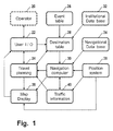
- Figure 1 shows an overall diagram of a system according to the invention, that by way of example has eleven subsystems, as follows.
- Block 20 symbolizes a user person who wants to be guided by the system.
- the user interfaces bidirectionally to the system's I/O 22 that may have various hardware and software facilities such as keyboard, mouse, speech, other audio, and display of text and/or maps.
- Block 32 represents an institutional data base that may store various entries, such as representing hotels, restaurants or other facilities, together with associated data such as location, business hours, and actual services present at those facilities.
- Block 34 represents a navigational data base that may store a road network, together with physical distances or travel time distances between representative points, road classification, and others.
- Block 36 represents a position system that detects an actual position of the vehicle, such as through a well known GPS system.
- Block 26 represents an event table, such as a road block or jam situation that has been communicated by a higher level authority such as as a R adio D ata S ystem, and which event may cause a certain destination to be no longer reacheable, or only in a delayed manner, or which may necessitate the vehicle to take a detour.
- a higher level authority such as as a R adio D ata S ystem
- Block 28 represents a destination table that contains the destinations and associated timing indications, such as entered by the user through block 22, and subject to information from the travel planning in block 24, the institutional data base in block 32, and the event table in block 26.
- Block 30 represents a navigational computer that is fed with the Destination Table from block 28, with the navigational data base from block 34, and with the position from block 36. From these informations it can figure out a route to be taken, which route may contain various interval points and timing indications associated to the various interval points.
- Block 24 represents the travel planning that is fed by the information from the navigational computer 30, and which block 24 furthermore bidirectionally interfaces to the destination table in block 28, and to the user I/O in block 22.
- the travel planning will update the destination table if it fails to find a correct solution for attaining all interval points. It will signal to the user what route is to be taken, and it will signal the above failure to allow the user to modify the set of interval points and/or associated timing indications.
- Block 40 represents the information of dynamic travel conditions that may be received in the same manner as the information of event table 26, such as through RDS/TMC or mobile radio, but that according to the present invention is used in a different and dynamic manner.
- the information is activated through an actual position received from subsystem 36, and further through the planned travel information received from subsystem 30.
- the activated information is communicated to navigational computer subsystem 30 and to travel planning subsystem 24, for influencing in a dynamic manner the planning of the route to be taken, subject to a dialog with the user person.
- Map display subsystem 38 receives information from block 24 regarding what route has been planned, from block 36 regarding what the actual position of the vehicle is, and from navigational computer subsystem 30 information regarding what route(s) will be feasible as alternative; the latter information is also fed back as activating information to subsystem 40.
- Figure 2 is an input example representing a user's requirements. As shown, the user wants to visits three firms x, y, z, each with its address provided, and also wants to have lunch at about 12 o'clock. Furthermore, the interval at firm x has its arrival time and departure time fully specified, the interval at firm y has its arrival time and its Stay length specified, and the interval at firm z has only its arrival time specified. Various items of the above may have been inputted into the system by speech from the user person, either before the commencement of the actual travelling, or even during the actual travel.
- Figure 3 is the result output presented by the system as meeting the user's requirements listed in Figure 2.
- the intervals at the three firms x, y and z have their arrival, departure and stay times fully specified as far as feasible.
- the system has sought for a suitable restaurant that would best meet the requirements of an arrival time near 12 o'clock, and a stay time that would be sufficient for lunch.
- restaurant q Using the institutional data base 32 and navigational data base 34 of Figure 1, it has come up with restaurant q at an address that would give one hour's and ten minutes' time, which was considered long enough.
- the associated departure time has been presented. In other cases, the system would signal that another sequence among the three firms to be visited would be necessary.
- Figure 4 is the changed output presented by the system as the result of an accident or other traffic problem on the interval between firms x and y while still meeting the user's requirements. It has been found necessary or advisable to change to another lunch address, to advance to start of lunch, and to shorten the interval allowable for lunch.
- the changes are printed fat, and in practice may be shown in a conspicuous color or other format, such as blinking or enlarged, and possibly through supportive or explicative speech.
- the user may agree with the amendments or not. In the latter case, the user may, for example, amend the arrival time at firm y, advance the departure time at firm x, or take such other measures as considered fit for the particular purpose. In this particular situation, the time interval between lunch and the planned arrival at destination y is increased; this allows to take a detour if the traffic impediment will still exist after lunch.
- Figure 5 demonstrates a few further dynamic effects of the present invention. For simplicity, only the lengths of the intervals are taken into account. If the route should call at all destinations A through F, the shortest path is sequentially along A, B, C, D, E, F. If there is a traffic block between B and C, the shortest route is sequentially along A, B, D, C, E, F. However, the user may find it be necessary to visit destination C before destination D. This will clearly necessitate a longer route, which the user may input into the system. This may again influence the traveling schedule.
- Figure 6 is an applicable flow chart of the operation of the route planning system according to the invention.
- An important aspect of the embodiment is, that the system will search first for alternatives that have minimum influence on the actual travel planning. If it proves impossible to maintain the actual planning, the system will undertake to change the planning overall.
- the other approach that is to only amend the departure and/or arrival times, will generally only diminish the times of stay. while extending the time spent on the road. Such procedure might however bring the user in a stressed situation, wherein it is undertaken to make good for the time lost in the traffic, and might cause further delay or even accidents.
- the preferred embodiment of the invention undertakes to implement one or more of the following:
- the system receives the traffic notification in question.
- the system detects whether the notification does influence the route planning, for example by checking the instant that the vehicle will pass a particular location against the interval during which the obstruction or other adverse condition is known or expected to persist. If negative (no influence), the system goes back to the waiting loop of block 44. If positive, the system first undertakes in block 48 to plan a detour.
- the system checks whether along the detour the original timing can still be maintained. If yes, the system in block 52 proposes the detour to the user. If the detour is accepted by the user indeed in block 66 (Y), the original route in block 64 is replaced by the new route, and the procedure is terminated in block 60. In fact, the system could as well go again to the waiting loop of block 44.
- the system checks in block 68 whether other possibilities are present. If no, the system goes to block 60, while signalling to the user a failure to find such other schedule. The latter may then still accept, or change the overall requirements or, for example, report to a superintendent authority that such failure has occurred. If in block 68 still further possibilities exist (Y), the system goes back to block 50.
- the system in block 54 undertakes to plan a new schedule.
- the user then may allow or reject this schedule in blocks 56, 58, just like in blocks 66, 68, and eventually, either the planning is corrected in block 62, or the system exits to block 60 when no further possibilities are present.
- This amending may be effected by the user person, in the form of speech, keystrokes or otherwise, and may pertain to the inserting or deleting of interval points, the amending of wanted stay times, and various other.
- the guiding of the vehicle may be changed in a dynamic manner, such as under the influence of external events or situations, such as traffic jams or rainstorms, or rather the discontinuance of such events or adverse situations.
- Such aspects may be dynamically communicated to the vehicle by known systems such as R adio D ata S ystem- TMC , M obile R adio, and others.
- This arrival of new information may require the driver to maintain to some degree a continuing and dynamic dialog with the overall system. Such could require the driver to change plans, because the dynamic situation may have any type of influence on the planned route.
Landscapes
- Engineering & Computer Science (AREA)
- Radar, Positioning & Navigation (AREA)
- Remote Sensing (AREA)
- Automation & Control Theory (AREA)
- Physics & Mathematics (AREA)
- General Physics & Mathematics (AREA)
- Navigation (AREA)
- Traffic Control Systems (AREA)
- Steering Control In Accordance With Driving Conditions (AREA)
Abstract
Description
- The invention relates to a navigation route planning system provided with various interlinked facilities, including a user I/O facility, a route planning facility, a position determination facility, and a destination and institutional table facility. Such system is known from US Patent 4,951,212. In this known navigation route planning system a user may enter a request for selecting a destination that is categorized according to its purpose of use, such as a supermarket. The system will then select the most suitable supermarket and guide the driver in accordance with the selection. The present inventor has recognized that this prior art organization is essentially static, and would not be able to cope in a dynamic manner with changes in the traffic conditions.
- The invention also relates to a method for operating a route planning system as described above.
- It is an object of the present invention to provide a route planning system that allows to enter a set of interval points each provided with associated timing indications and which system then will generate a route and an associated timing schedule that accommodate to the set of interval points inclusive of coping in a dynamic manner with changes in traffic conditions.
- A navigation route planning system provided with various interlinked facilities, including a user I/O facility, a route planning facility, a position determination facility, and a destination and institutional table facility according to the invention is therefore characterized in that said route planning facility is arranged for under control of a set of interval point requests received from a user, one or more timing indications each associated to a respective interval point request, and furthermore dynamic traffic condition informations received from an overall notification system, dynamically generating a route listing for a route to be travelled in accordance with the interval points, associated timing indications and dynamic traffic condition informations.
- To improve the user interface, such navigation system is preferably characterized by said overall notification system putting forward one or more proposals for acceptance or rejection by a user.
- Further user interface improvements are obtained in preferred embodiments of the invention, characterized by the overall notification system in said putting forward prioritising a proposal that maintains an earlier and actually effective traveling schedule and/or characterized in that a failure to maintain said effective schedule triggers an overall replanning of the route instead of a partial adaptation.
- These and further aspects and advantages of the invention will be discussed more in detail hereinafter with reference to the disclosure of preferred embodiments, and in particular with reference to the appended Figures that show:
- Figure 1 shows an overall diagram of a system according to the invention;
- Figure 2 is an input example representing a user's requirements;
- Figure 3 is a first result output presented by the system;
- Figure 4 is a second result output after a planning change caused by a traffic accident;
- Figure 5 demonstrates a few further dynamic effects;
- Figure 6 is an applicable flow chart.
-
- Amongst other things, it is an object of the present invention to support the user in planning a journey and to update the planning in a dynamic manner as depending on actual traffic conditions. A prerequisite for using the system is the availability of a navigation system that includes the supporting of the travel planning, as recited in copending application EP Appl. No 99204046.9.
- The companion invention provides for inputting spatial targets as well as temporal targets for generating interval points in a dynamic manner. The present invention furthermore provides to allow receiving information regarding traffic conditions, and in particular traffic problems, for on the basis thereon, informing the user on the problems themselves, as well as on possible detours and other changes in the route planning.
- After the user has inputted all requirements for the travel, the system will calculate an optimum sequence for going to the various destinations. The sequence may at any instant be amended by the user. Now in particular, the setting of the route should take into account actual traffic conditions. Because these may in general undergo continual changes, the route planning is being adapted in a dynamic manner. To keep this adapting transparent to the user person, the system will notify the user of such necessary or useful changes that will have occurred on the ground of the actual traffic conditions. The user may ultimately decide on the changing or maintaining of the route.
- The user will not only get an advice on a detour preferred by the system, but will also get the possibility to adapt the overall planning of the route. The changes may pertain to the temporal sequence or on the spatial configuration of certain destinations. Various examples are as follows:
- A particular traffic problem may negatively influence the expected duration of travel. In such case, various times, such as time of departure and time of stay may have to be corrected, if destination, time of arrival, and activity have been specified. An "activity" may for example be a legally prescribed rest interval, or a meal.
- A particular traffic problem may render a different sequence in time and space among the destinations preferable over the original one.
- When a particular activity, such as lunch, had been used to therefrom derive a destination location, then the occurring traffic problem may lead to assign this activity to a different destination. Also the instant assigned to this activity may be amended, such as through having lunch earlier, or through waiting for the adverse condition to be solved.
- The above examples pertain to the dynamic beginning of a traffic problem. It is likewise possible that a particular traffic problem will be solved in the course of time, or even that its nature or location will be changed. For example, a traffic jam due to the travel of an exceptional vehicle will probably move together with that particular vehicle. In such situations, the facilities provided by the invention will remain likewise applicable.
- Now, the amendments generated by the system may be considered by the user as mere proposals, that may be accepted or rejected. In particular, to accommodate to the user's own wishes regarding the contination of the journey, the system may indicate the grounds leading to the proposals for change. This indication may be done in text, in speech, or through representing the situation on a map of a useful scale and area. The proposed amendments may be shown on the map and/or in tabular form.
- Figure 1 shows an overall diagram of a system according to the invention, that by way of example has eleven subsystems, as follows.
Block 20 symbolizes a user person who wants to be guided by the system. The user interfaces bidirectionally to the system's I/O 22 that may have various hardware and software facilities such as keyboard, mouse, speech, other audio, and display of text and/or maps.Block 32 represents an institutional data base that may store various entries, such as representing hotels, restaurants or other facilities, together with associated data such as location, business hours, and actual services present at those facilities.Block 34 represents a navigational data base that may store a road network, together with physical distances or travel time distances between representative points, road classification, and others.Block 36 represents a position system that detects an actual position of the vehicle, such as through a well known GPS system.Block 26 represents an event table, such as a road block or jam situation that has been communicated by a higher level authority such as as a Radio Data System, and which event may cause a certain destination to be no longer reacheable, or only in a delayed manner, or which may necessitate the vehicle to take a detour. -
Block 28 represents a destination table that contains the destinations and associated timing indications, such as entered by the user throughblock 22, and subject to information from the travel planning inblock 24, the institutional data base inblock 32, and the event table inblock 26.Block 30 represents a navigational computer that is fed with the Destination Table fromblock 28, with the navigational data base fromblock 34, and with the position fromblock 36. From these informations it can figure out a route to be taken, which route may contain various interval points and timing indications associated to the various interval points.Block 24 represents the travel planning that is fed by the information from thenavigational computer 30, and which block 24 furthermore bidirectionally interfaces to the destination table inblock 28, and to the user I/O inblock 22. The travel planning will update the destination table if it fails to find a correct solution for attaining all interval points. It will signal to the user what route is to be taken, and it will signal the above failure to allow the user to modify the set of interval points and/or associated timing indications. -
Block 40 represents the information of dynamic travel conditions that may be received in the same manner as the information of event table 26, such as through RDS/TMC or mobile radio, but that according to the present invention is used in a different and dynamic manner. The information is activated through an actual position received fromsubsystem 36, and further through the planned travel information received fromsubsystem 30. The activated information is communicated tonavigational computer subsystem 30 and totravel planning subsystem 24, for influencing in a dynamic manner the planning of the route to be taken, subject to a dialog with the user person.Map display subsystem 38 receives information fromblock 24 regarding what route has been planned, fromblock 36 regarding what the actual position of the vehicle is, and fromnavigational computer subsystem 30 information regarding what route(s) will be feasible as alternative; the latter information is also fed back as activating information tosubsystem 40. - Figure 2 is an input example representing a user's requirements. As shown, the user wants to visits three firms x, y, z, each with its address provided, and also wants to have lunch at about 12 o'clock. Furthermore, the interval at firm x has its arrival time and departure time fully specified, the interval at firm y has its arrival time and its Stay length specified, and the interval at firm z has only its arrival time specified. Various items of the above may have been inputted into the system by speech from the user person, either before the commencement of the actual travelling, or even during the actual travel.
- Figure 3 is the result output presented by the system as meeting the user's requirements listed in Figure 2. First, the intervals at the three firms x, y and z have their arrival, departure and stay times fully specified as far as feasible. Furthermore, the system has sought for a suitable restaurant that would best meet the requirements of an arrival time near 12 o'clock, and a stay time that would be sufficient for lunch. Using the
institutional data base 32 andnavigational data base 34 of Figure 1, it has come up with restaurant q at an address that would give one hour's and ten minutes' time, which was considered long enough. Also, the associated departure time has been presented. In other cases, the system would signal that another sequence among the three firms to be visited would be necessary. For example, it could be necessary to have lunch between the visits to firms y and z, respectively, if the available restaurant was more down the road, or the system could signal that the requirements could not be met. In such case, the user could indicate another sequence of the visits, or could even relinquish the requirement for a specified sequence, and leave it to be determined by the system itself. Still another case could occur, where the system would for example find that the three firms were too far from each other, given the various required Stay lengths, to be visited on a single day. - Figure 4 is the changed output presented by the system as the result of an accident or other traffic problem on the interval between firms x and y while still meeting the user's requirements. It has been found necessary or advisable to change to another lunch address, to advance to start of lunch, and to shorten the interval allowable for lunch. For better information, the changes are printed fat, and in practice may be shown in a conspicuous color or other format, such as blinking or enlarged, and possibly through supportive or explicative speech. The user may agree with the amendments or not. In the latter case, the user may, for example, amend the arrival time at firm y, advance the departure time at firm x, or take such other measures as considered fit for the particular purpose. In this particular situation, the time interval between lunch and the planned arrival at destination y is increased; this allows to take a detour if the traffic impediment will still exist after lunch.
- Figure 5 demonstrates a few further dynamic effects of the present invention. For simplicity, only the lengths of the intervals are taken into account. If the route should call at all destinations A through F, the shortest path is sequentially along A, B, C, D, E, F. If there is a traffic block between B and C, the shortest route is sequentially along A, B, D, C, E, F. However, the user may find it be necessary to visit destination C before destination D. This will clearly necessitate a longer route, which the user may input into the system. This may again influence the traveling schedule.
- Figure 6 is an applicable flow chart of the operation of the route planning system according to the invention. An important aspect of the embodiment is, that the system will search first for alternatives that have minimum influence on the actual travel planning. If it proves impossible to maintain the actual planning, the system will undertake to change the planning overall. The other approach, that is to only amend the departure and/or arrival times, will generally only diminish the times of stay. while extending the time spent on the road. Such procedure might however bring the user in a stressed situation, wherein it is undertaken to make good for the time lost in the traffic, and might cause further delay or even accidents. In contradistinction, the preferred embodiment of the invention undertakes to implement one or more of the following:
- optimize the sequence wherein the various destinations will be reached;
- to shift an activity so that the user would benefit by spending time for other purposes instead of standing idle in an extended traffic jam;
- having an activity at such location that is not involved in the traffic problem at all.
- Now in particular, in
block 42 the system is started, the necessary hardware and software facilities are assigned and the original route is planned. Inblock 44, the system receives the traffic notification in question. Inblock 46, the system detects whether the notification does influence the route planning, for example by checking the instant that the vehicle will pass a particular location against the interval during which the obstruction or other adverse condition is known or expected to persist. If negative (no influence), the system goes back to the waiting loop ofblock 44. If positive, the system first undertakes inblock 48 to plan a detour. Next, inblock 50 the system checks whether along the detour the original timing can still be maintained. If yes, the system inblock 52 proposes the detour to the user. If the detour is accepted by the user indeed in block 66 (Y), the original route inblock 64 is replaced by the new route, and the procedure is terminated inblock 60. In fact, the system could as well go again to the waiting loop ofblock 44. - If on the other hand, the user rejects the proposed route in
block 66, the system checks in block 68 whether other possibilities are present. If no, the system goes to block 60, while signalling to the user a failure to find such other schedule. The latter may then still accept, or change the overall requirements or, for example, report to a superintendent authority that such failure has occurred. If in block 68 still further possibilities exist (Y), the system goes back to block 50. - If in
block 50 the original schedule cannot be maintained (N), the system inblock 54 undertakes to plan a new schedule. The user then may allow or reject this schedule inblocks blocks 66, 68, and eventually, either the planning is corrected inblock 62, or the system exits to block 60 when no further possibilities are present. - During the actual travel, it remains possible to amend the schedule. This amending may be effected by the user person, in the form of speech, keystrokes or otherwise, and may pertain to the inserting or deleting of interval points, the amending of wanted stay times, and various other. Also, the guiding of the vehicle may be changed in a dynamic manner, such as under the influence of external events or situations, such as traffic jams or rainstorms, or rather the discontinuance of such events or adverse situations. Such aspects may be dynamically communicated to the vehicle by known systems such as Radio Data System-TMC, MobileRadio, and others. This arrival of new information may require the driver to maintain to some degree a continuing and dynamic dialog with the overall system. Such could require the driver to change plans, because the dynamic situation may have any type of influence on the planned route.
- The person skilled in the art of route planning will recognize further policies to be followed within the ambit of the present invention, the scope of which has justfully been determined by the appended claims hereinafter.
Claims (9)
- A navigation route planning system provided with various interlinked facilities, including a user I/O facility, a route planning facility, a position determination facility, and a destination and institutional table facility, characterized in that said route planning facility is arranged for under control of a set of interval point requests received from a user, one or more timing indications each associated to a respective interval point request, and furthermore dynamic traffic condition informations received from an overall notification system, dynamically generating a route listing for a route to be travelled in accordance with the interval points, associated timing indications and dynamic traffic condition informations.
- A navigation system as claimed in claim 1, characterized by said overall notification system putting forward one or more proposals for acceptance or rejection by a user.
- A navigation system as claimed in claim 2, characterized by the overall notification system in said putting forward prioritising a proposal that maintains an earlier and actually effective traveling schedule.
- A navigation system as claimed in claim 3, characterized in that a failure to maintain said effective schedule triggers an overall replanning of the route instead of a partial adaptation.
- A navigation system as claimed in claim 1, characterized by reject recognition means for after said generating detecting a user reject or amendment signal, and reactivating said route planning facility for thereupon generating an amended route listing.
- A navigation system as claimed in claim 1, characterized by failure signalization means for under control of a failure with respect to accommodating said route, signalizing a failure signal and enabling the user to enter an amendment.
- A navigation system as claimed in claim 1, characterized by a speech reception facility for allowing a user person to enter amendment and/or reject signals in the form of speech.
- A navigation system as claimed in claim 7, characterized by further having receiving means for receiving external condition signalizations from an overall long-range signalization or broadcast system, such as RDS-TMC or mobile radio.
- A method for operating a navigation route planning system as claimed in claim 1, that is provided with various interlinked facilities, including a user I/O facility, a route planning facility, a position determination facility, and a destination and institutional table facility, characterized in that said method comprises the steps of user-entering into the system a set of interval point requests received from a user and one or more timing indications each associated to a respective interval point request, and furthermore detecting dynamic traffic condition informations received from an overall notification system, and user-inducing said system to dynamically generate a route listing for a route to be travelled in accordance with the interval points, associated timing indications and dynamic traffic condition informations.
Priority Applications (6)
| Application Number | Priority Date | Filing Date | Title |
|---|---|---|---|
| DE60039412T DE60039412D1 (en) | 2000-05-04 | 2000-05-04 | Navigation route planning system |
| EP00201620A EP1152220B1 (en) | 2000-05-04 | 2000-05-04 | Navigation route planning system |
| AT00201620T ATE400793T1 (en) | 2000-05-04 | 2000-05-04 | NAVIGATION ROUTE PLANNING SYSTEM |
| AU33430/01A AU3343001A (en) | 2000-05-04 | 2001-04-03 | Navigation route planning system |
| JP2001134594A JP2002013941A (en) | 2000-05-04 | 2001-05-01 | Navigation route planning system |
| US09/849,849 US20020004700A1 (en) | 2000-05-04 | 2001-05-04 | Navigation route planning system |
Applications Claiming Priority (1)
| Application Number | Priority Date | Filing Date | Title |
|---|---|---|---|
| EP00201620A EP1152220B1 (en) | 2000-05-04 | 2000-05-04 | Navigation route planning system |
Publications (2)
| Publication Number | Publication Date |
|---|---|
| EP1152220A1 true EP1152220A1 (en) | 2001-11-07 |
| EP1152220B1 EP1152220B1 (en) | 2008-07-09 |
Family
ID=8171454
Family Applications (1)
| Application Number | Title | Priority Date | Filing Date |
|---|---|---|---|
| EP00201620A Expired - Lifetime EP1152220B1 (en) | 2000-05-04 | 2000-05-04 | Navigation route planning system |
Country Status (6)
| Country | Link |
|---|---|
| US (1) | US20020004700A1 (en) |
| EP (1) | EP1152220B1 (en) |
| JP (1) | JP2002013941A (en) |
| AT (1) | ATE400793T1 (en) |
| AU (1) | AU3343001A (en) |
| DE (1) | DE60039412D1 (en) |
Cited By (8)
| Publication number | Priority date | Publication date | Assignee | Title |
|---|---|---|---|---|
| EP1610093A1 (en) * | 2003-04-03 | 2005-12-28 | Pioneer Corporation | Navigation device, navigation method, route data generation program, recording medium containing route data generation program, and server device in navigation system |
| DE102005005413A1 (en) * | 2005-02-05 | 2006-08-17 | Christian Dr. Köppel | Method and device for route planning |
| EP1717557A1 (en) * | 2004-02-17 | 2006-11-02 | Kabushiki Kaisha Kenwood | Guidance route search device, navigation device, and method of searching guidance route |
| DE102011010584A1 (en) * | 2011-02-08 | 2012-08-09 | Audi Ag | Method and system for automated scheduling of a meeting of at least two participants |
| RU2471238C2 (en) * | 2008-07-11 | 2012-12-27 | Теле Атлас Б.В. | Device and method of displaying type of road junction |
| DE102014200615A1 (en) * | 2014-01-15 | 2015-07-16 | Volkswagen Aktiengesellschaft | Procedure for a navigation system |
| CN108446332A (en) * | 2017-02-16 | 2018-08-24 | 株式会社咕嘟妈咪 | Information processing unit, information processing method and program |
| US11415427B2 (en) | 2017-12-15 | 2022-08-16 | Google Llc | Providing traffic warnings to a user based on return journey |
Families Citing this family (22)
| Publication number | Priority date | Publication date | Assignee | Title |
|---|---|---|---|---|
| AU2003282786A1 (en) * | 2002-08-30 | 2004-03-19 | Racom Products | Modular analog wireless data telemetry system adapted for use with web based location information distribution method and method for developing and disseminating information for use therewith |
| AU2003288909A1 (en) * | 2002-09-20 | 2004-04-08 | Racom Products, Inc. | Method for wireless data system distribution and disseminating information for use with web base location information |
| US20070168118A1 (en) * | 2003-06-27 | 2007-07-19 | Dirk Lappe | System for coordinating the routes of navigation devices |
| EP1491858A1 (en) * | 2003-06-27 | 2004-12-29 | Harman Becker Automotive Systems GmbH | Navigation method and system |
| DE602004023313D1 (en) * | 2003-09-30 | 2009-11-05 | Kenwood Corp | GUIDE ROUTE SEARCH METHOD |
| US20080097688A1 (en) * | 2006-06-27 | 2008-04-24 | Microsoft Corporation | Route generation based upon activity criteria |
| US8793066B2 (en) * | 2006-06-27 | 2014-07-29 | Microsoft Corporation | Route monetization |
| US7610151B2 (en) * | 2006-06-27 | 2009-10-27 | Microsoft Corporation | Collaborative route planning for generating personalized and context-sensitive routing recommendations |
| US20090150167A1 (en) * | 2007-12-07 | 2009-06-11 | General Motors Corporation | Method for organizing data presented to a user in a vehicle |
| US20090157540A1 (en) * | 2007-12-14 | 2009-06-18 | Microsoft Corporation | Destination auctioned through business of interest |
| US8473198B2 (en) * | 2007-12-14 | 2013-06-25 | Microsoft Corporation | Additional content based on intended travel destination |
| US8428859B2 (en) * | 2007-12-14 | 2013-04-23 | Microsoft Corporation | Federated route production |
| US8060297B2 (en) * | 2007-12-14 | 2011-11-15 | Microsoft Corporation | Route transfer between devices |
| US20090157499A1 (en) * | 2007-12-14 | 2009-06-18 | Microsoft Corporation | Automatic splices for targeted advertisements |
| US20090157498A1 (en) * | 2007-12-14 | 2009-06-18 | Microsoft Corporation | Generational intelligent navigation synchronization or update |
| US8090532B2 (en) * | 2007-12-14 | 2012-01-03 | Microsoft Corporation | Pedestrian route production |
| US8793065B2 (en) | 2008-02-19 | 2014-07-29 | Microsoft Corporation | Route-based activity planner |
| US20090210302A1 (en) * | 2008-02-19 | 2009-08-20 | Microsoft Corporation | Route reward augmentation |
| US8855919B2 (en) * | 2010-12-02 | 2014-10-07 | Telenav, Inc. | Navigation system with destination-centric en-route notification delivery mechanism and method of operation thereof |
| EP2936835A1 (en) | 2012-12-21 | 2015-10-28 | Widex A/S | Method of operating a hearing aid and a hearing aid |
| KR101575051B1 (en) * | 2014-06-13 | 2015-12-21 | 엘지전자 주식회사 | Wearable device and method for controlling the same |
| JP6663897B2 (en) * | 2017-02-16 | 2020-03-13 | 株式会社ぐるなび | Information processing apparatus, information processing method and program |
Citations (4)
| Publication number | Priority date | Publication date | Assignee | Title |
|---|---|---|---|---|
| EP0785519A1 (en) * | 1996-01-22 | 1997-07-23 | Toyota Jidosha Kabushiki Kaisha | Itinerary preparing system |
| EP0788067A1 (en) * | 1996-01-31 | 1997-08-06 | Toyota Jidosha Kabushiki Kaisha | Itinerary making system |
| EP0795835A1 (en) * | 1994-12-01 | 1997-09-17 | Toyota Jidosha Kabushiki Kaisha | Schedule setting and processing system |
| FR2762906A1 (en) * | 1997-05-02 | 1998-11-06 | Renault | Vehicle guidance procedure has a connection to a remote database |
Family Cites Families (25)
| Publication number | Priority date | Publication date | Assignee | Title |
|---|---|---|---|---|
| US5222249A (en) * | 1990-11-08 | 1993-06-22 | Motorola, Inc. | Dynamic rf communication resource access by roving mobile units |
| US5172321A (en) * | 1990-12-10 | 1992-12-15 | Motorola, Inc. | Vehicle route planning system |
| US5467276A (en) * | 1991-06-05 | 1995-11-14 | Tsuyuki; Toshio | Navigation apparatus and method |
| DE4408982C1 (en) * | 1994-03-16 | 1995-05-18 | Deutsche Forsch Luft Raumfahrt | Autonomous navigation system for mobile robot or manipulator |
| US5948040A (en) * | 1994-06-24 | 1999-09-07 | Delorme Publishing Co. | Travel reservation information and planning system |
| CA2158500C (en) * | 1994-11-04 | 1999-03-30 | Ender Ayanoglu | Navigation system for an automotive vehicle |
| US5610821A (en) * | 1994-11-18 | 1997-03-11 | Ibm Corporation | Optimal and stable route planning system |
| US5648768A (en) * | 1994-12-30 | 1997-07-15 | Mapsys, Inc. | System and method for identifying, tabulating and presenting information of interest along a travel route |
| US5612882A (en) * | 1995-02-01 | 1997-03-18 | Lefebvre; Rebecca K. | Method and apparatus for providing navigation guidance |
| WO1996029688A1 (en) * | 1995-03-23 | 1996-09-26 | Detemobil Deutsche Telekom Mobilnet Gmbh | Method and system for determining dynamic traffic information |
| US5933100A (en) * | 1995-12-27 | 1999-08-03 | Mitsubishi Electric Information Technology Center America, Inc. | Automobile navigation system with dynamic traffic data |
| JPH09204475A (en) * | 1996-01-24 | 1997-08-05 | Toyota Motor Corp | Travel plan generation device |
| US6198696B1 (en) * | 1999-06-16 | 2001-03-06 | Siemens Information And Communication Networks, Inc. | Device and method for tracking time zone changes in communications devices |
| US5819201A (en) * | 1996-09-13 | 1998-10-06 | Magellan Dis, Inc. | Navigation system with vehicle service information |
| DE19644689A1 (en) * | 1996-10-26 | 1998-04-30 | Philips Patentverwaltung | Navigation system for a land vehicle |
| US6680694B1 (en) * | 1997-08-19 | 2004-01-20 | Siemens Vdo Automotive Corporation | Vehicle information system |
| JP2001504972A (en) * | 1997-09-03 | 2001-04-10 | マネスマン ファウデーオー アクチェンゲゼルシャフト | Vehicle navigation system |
| DE69817306T2 (en) * | 1997-12-02 | 2004-06-24 | Siemens Ag | Device for processing a traffic announcement |
| JP3548459B2 (en) * | 1998-11-20 | 2004-07-28 | 富士通株式会社 | Guide information presenting apparatus, guide information presenting processing method, recording medium recording guide information presenting program, guide script generating apparatus, guide information providing apparatus, guide information providing method, and guide information providing program recording medium |
| US6798867B1 (en) * | 1999-09-13 | 2004-09-28 | Microstrategy, Incorporated | System and method for the creation and automatic deployment of personalized, dynamic and interactive voice services, with real-time database queries |
| US6349257B1 (en) * | 1999-09-15 | 2002-02-19 | International Business Machines Corporation | System for personalized mobile navigation information |
| US6317684B1 (en) * | 1999-12-22 | 2001-11-13 | At&T Wireless Services Inc. | Method and apparatus for navigation using a portable communication device |
| US6317685B1 (en) * | 2000-03-13 | 2001-11-13 | Navigation Technologies Corp. | Method and system for providing alternate routes with a navigation system |
| US6480783B1 (en) * | 2000-03-17 | 2002-11-12 | Makor Issues And Rights Ltd. | Real time vehicle guidance and forecasting system under traffic jam conditions |
| EP1150099A1 (en) * | 2000-04-28 | 2001-10-31 | Mannesmann VDO Aktiengesellschaft | A vehicle information processing system and method |
-
2000
- 2000-05-04 AT AT00201620T patent/ATE400793T1/en not_active IP Right Cessation
- 2000-05-04 EP EP00201620A patent/EP1152220B1/en not_active Expired - Lifetime
- 2000-05-04 DE DE60039412T patent/DE60039412D1/en not_active Expired - Lifetime
-
2001
- 2001-04-03 AU AU33430/01A patent/AU3343001A/en not_active Abandoned
- 2001-05-01 JP JP2001134594A patent/JP2002013941A/en active Pending
- 2001-05-04 US US09/849,849 patent/US20020004700A1/en not_active Abandoned
Patent Citations (4)
| Publication number | Priority date | Publication date | Assignee | Title |
|---|---|---|---|---|
| EP0795835A1 (en) * | 1994-12-01 | 1997-09-17 | Toyota Jidosha Kabushiki Kaisha | Schedule setting and processing system |
| EP0785519A1 (en) * | 1996-01-22 | 1997-07-23 | Toyota Jidosha Kabushiki Kaisha | Itinerary preparing system |
| EP0788067A1 (en) * | 1996-01-31 | 1997-08-06 | Toyota Jidosha Kabushiki Kaisha | Itinerary making system |
| FR2762906A1 (en) * | 1997-05-02 | 1998-11-06 | Renault | Vehicle guidance procedure has a connection to a remote database |
Cited By (17)
| Publication number | Priority date | Publication date | Assignee | Title |
|---|---|---|---|---|
| EP1610093A1 (en) * | 2003-04-03 | 2005-12-28 | Pioneer Corporation | Navigation device, navigation method, route data generation program, recording medium containing route data generation program, and server device in navigation system |
| EP1610093A4 (en) * | 2003-04-03 | 2011-01-05 | Navigation device, navigation method, route data generation program, recording medium containing route data generation program, and server device in navigation system | |
| EP1717557A1 (en) * | 2004-02-17 | 2006-11-02 | Kabushiki Kaisha Kenwood | Guidance route search device, navigation device, and method of searching guidance route |
| EP1717557A4 (en) * | 2004-02-17 | 2011-01-19 | Kenwood Corp | Guidance route search device, navigation device, and method of searching guidance route |
| US7937214B2 (en) | 2004-02-17 | 2011-05-03 | Kabushiki Kaisha Kenwood | Guidance route search device, navigation device, and method of searching guidance route |
| DE102005005413A1 (en) * | 2005-02-05 | 2006-08-17 | Christian Dr. Köppel | Method and device for route planning |
| DE102005005413B4 (en) * | 2005-02-05 | 2006-12-07 | Christian Dr. Köppel | Method and device for route planning |
| RU2471238C2 (en) * | 2008-07-11 | 2012-12-27 | Теле Атлас Б.В. | Device and method of displaying type of road junction |
| DE102011010584A1 (en) * | 2011-02-08 | 2012-08-09 | Audi Ag | Method and system for automated scheduling of a meeting of at least two participants |
| US8965972B2 (en) | 2011-02-08 | 2015-02-24 | Audi Ag | Method and system for the automated planning of a meeting between at least two participants |
| DE102014200615A1 (en) * | 2014-01-15 | 2015-07-16 | Volkswagen Aktiengesellschaft | Procedure for a navigation system |
| CN108446332A (en) * | 2017-02-16 | 2018-08-24 | 株式会社咕嘟妈咪 | Information processing unit, information processing method and program |
| EP3372959A3 (en) * | 2017-02-16 | 2018-11-28 | Gurunavi, Inc. | Information processing apparatus, information processing method and program |
| US10977584B2 (en) | 2017-02-16 | 2021-04-13 | Gurunavi, Inc. | Information processing apparatus information processing method and storage medium |
| US11055637B2 (en) | 2017-02-16 | 2021-07-06 | Gurunavi, Inc. | Information processing apparatus, information processing method and storage medium |
| CN108446332B (en) * | 2017-02-16 | 2022-09-20 | 株式会社咕嘟妈咪 | Information processing apparatus, information processing method, and program |
| US11415427B2 (en) | 2017-12-15 | 2022-08-16 | Google Llc | Providing traffic warnings to a user based on return journey |
Also Published As
| Publication number | Publication date |
|---|---|
| US20020004700A1 (en) | 2002-01-10 |
| ATE400793T1 (en) | 2008-07-15 |
| DE60039412D1 (en) | 2008-08-21 |
| EP1152220B1 (en) | 2008-07-09 |
| JP2002013941A (en) | 2002-01-18 |
| AU3343001A (en) | 2001-11-08 |
Similar Documents
| Publication | Publication Date | Title |
|---|---|---|
| EP1152220B1 (en) | Navigation route planning system | |
| US10302443B2 (en) | Navigation server and program | |
| EP1909069B1 (en) | Intelligent destination setting for navigation systems | |
| US8131467B2 (en) | Route information display device and route information display method | |
| US8457888B2 (en) | Method for reminding users about future appointments while taking into account traveling time to the appointment location | |
| US20200003571A1 (en) | Information processing device, information processing method, and information processing program product | |
| US7937214B2 (en) | Guidance route search device, navigation device, and method of searching guidance route | |
| JP4266173B2 (en) | Guide route search device | |
| EP1134716A1 (en) | A route planning system | |
| US20050114014A1 (en) | System and method to notify a person of a traveler's estimated time of arrival | |
| EP0834850A1 (en) | Method and apparatus for use in selecting a destination in a navigation system for vehicle | |
| JP2012127770A (en) | Route search method and device | |
| WO2008083862A1 (en) | Method of indicating traffic delays, computer program and navigation system therefor | |
| US20160033290A1 (en) | Vehicular information providing apparatus | |
| JP2003121182A (en) | Navigation apparatus | |
| JP2000258177A (en) | Navigation device and storage medium | |
| KR20100007339A (en) | Navigation and method for searching path consideration user behavior | |
| EP1106968A1 (en) | Navigation system | |
| JP2000258178A (en) | Navigation device and storage medium | |
| CN112945243A (en) | Facility information display system, facility information display device, and storage medium | |
| JP2004102928A (en) | Memory auxiliary device and method therefor | |
| JP2000258173A (en) | Navigation device and storage medium | |
| JP4555583B2 (en) | Guide route search device, navigation device, and guide route search method | |
| JP2004144537A (en) | Route selecting system | |
| JP2019168277A (en) | Navigation device, navigation method, and program |
Legal Events
| Date | Code | Title | Description |
|---|---|---|---|
| PUAI | Public reference made under article 153(3) epc to a published international application that has entered the european phase |
Free format text: ORIGINAL CODE: 0009012 |
|
| AK | Designated contracting states |
Kind code of ref document: A1 Designated state(s): AT BE CH CY DE DK ES FI FR GB GR IE IT LI LU MC NL PT SE |
|
| AX | Request for extension of the european patent |
Free format text: AL;LT;LV;MK;RO;SI |
|
| RAP1 | Party data changed (applicant data changed or rights of an application transferred) |
Owner name: SIEMENS AKTIENGESELLSCHAFT |
|
| 17P | Request for examination filed |
Effective date: 20020318 |
|
| AKX | Designation fees paid |
Free format text: AT BE CH CY DE DK ES FI FR GB GR IE IT LI LU MC NL PT SE |
|
| 17Q | First examination report despatched |
Effective date: 20051109 |
|
| GRAP | Despatch of communication of intention to grant a patent |
Free format text: ORIGINAL CODE: EPIDOSNIGR1 |
|
| GRAS | Grant fee paid |
Free format text: ORIGINAL CODE: EPIDOSNIGR3 |
|
| RAP1 | Party data changed (applicant data changed or rights of an application transferred) |
Owner name: CONTINENTAL AUTOMOTIVE GMBH |
|
| GRAA | (expected) grant |
Free format text: ORIGINAL CODE: 0009210 |
|
| AK | Designated contracting states |
Kind code of ref document: B1 Designated state(s): AT BE CH CY DE DK ES FI FR GB GR IE IT LI LU MC NL PT SE |
|
| REG | Reference to a national code |
Ref country code: GB Ref legal event code: FG4D |
|
| REG | Reference to a national code |
Ref country code: CH Ref legal event code: EP |
|
| REF | Corresponds to: |
Ref document number: 60039412 Country of ref document: DE Date of ref document: 20080821 Kind code of ref document: P |
|
| REG | Reference to a national code |
Ref country code: IE Ref legal event code: FG4D |
|
| NLV1 | Nl: lapsed or annulled due to failure to fulfill the requirements of art. 29p and 29m of the patents act | ||
| PG25 | Lapsed in a contracting state [announced via postgrant information from national office to epo] |
Ref country code: PT Free format text: LAPSE BECAUSE OF FAILURE TO SUBMIT A TRANSLATION OF THE DESCRIPTION OR TO PAY THE FEE WITHIN THE PRESCRIBED TIME-LIMIT Effective date: 20081209 Ref country code: ES Free format text: LAPSE BECAUSE OF FAILURE TO SUBMIT A TRANSLATION OF THE DESCRIPTION OR TO PAY THE FEE WITHIN THE PRESCRIBED TIME-LIMIT Effective date: 20081020 Ref country code: NL Free format text: LAPSE BECAUSE OF FAILURE TO SUBMIT A TRANSLATION OF THE DESCRIPTION OR TO PAY THE FEE WITHIN THE PRESCRIBED TIME-LIMIT Effective date: 20080709 |
|
| PG25 | Lapsed in a contracting state [announced via postgrant information from national office to epo] |
Ref country code: AT Free format text: LAPSE BECAUSE OF FAILURE TO SUBMIT A TRANSLATION OF THE DESCRIPTION OR TO PAY THE FEE WITHIN THE PRESCRIBED TIME-LIMIT Effective date: 20080709 Ref country code: FI Free format text: LAPSE BECAUSE OF FAILURE TO SUBMIT A TRANSLATION OF THE DESCRIPTION OR TO PAY THE FEE WITHIN THE PRESCRIBED TIME-LIMIT Effective date: 20080709 |
|
| PG25 | Lapsed in a contracting state [announced via postgrant information from national office to epo] |
Ref country code: BE Free format text: LAPSE BECAUSE OF FAILURE TO SUBMIT A TRANSLATION OF THE DESCRIPTION OR TO PAY THE FEE WITHIN THE PRESCRIBED TIME-LIMIT Effective date: 20080709 |
|
| PG25 | Lapsed in a contracting state [announced via postgrant information from national office to epo] |
Ref country code: DK Free format text: LAPSE BECAUSE OF FAILURE TO SUBMIT A TRANSLATION OF THE DESCRIPTION OR TO PAY THE FEE WITHIN THE PRESCRIBED TIME-LIMIT Effective date: 20080709 |
|
| PLBE | No opposition filed within time limit |
Free format text: ORIGINAL CODE: 0009261 |
|
| STAA | Information on the status of an ep patent application or granted ep patent |
Free format text: STATUS: NO OPPOSITION FILED WITHIN TIME LIMIT |
|
| 26N | No opposition filed |
Effective date: 20090414 |
|
| PG25 | Lapsed in a contracting state [announced via postgrant information from national office to epo] |
Ref country code: MC Free format text: LAPSE BECAUSE OF NON-PAYMENT OF DUE FEES Effective date: 20090531 |
|
| REG | Reference to a national code |
Ref country code: CH Ref legal event code: PL |
|
| PG25 | Lapsed in a contracting state [announced via postgrant information from national office to epo] |
Ref country code: LI Free format text: LAPSE BECAUSE OF NON-PAYMENT OF DUE FEES Effective date: 20090531 Ref country code: CH Free format text: LAPSE BECAUSE OF NON-PAYMENT OF DUE FEES Effective date: 20090531 Ref country code: SE Free format text: LAPSE BECAUSE OF FAILURE TO SUBMIT A TRANSLATION OF THE DESCRIPTION OR TO PAY THE FEE WITHIN THE PRESCRIBED TIME-LIMIT Effective date: 20081009 |
|
| PG25 | Lapsed in a contracting state [announced via postgrant information from national office to epo] |
Ref country code: IE Free format text: LAPSE BECAUSE OF NON-PAYMENT OF DUE FEES Effective date: 20090504 |
|
| PG25 | Lapsed in a contracting state [announced via postgrant information from national office to epo] |
Ref country code: GR Free format text: LAPSE BECAUSE OF FAILURE TO SUBMIT A TRANSLATION OF THE DESCRIPTION OR TO PAY THE FEE WITHIN THE PRESCRIBED TIME-LIMIT Effective date: 20081010 |
|
| PG25 | Lapsed in a contracting state [announced via postgrant information from national office to epo] |
Ref country code: LU Free format text: LAPSE BECAUSE OF NON-PAYMENT OF DUE FEES Effective date: 20090504 |
|
| PG25 | Lapsed in a contracting state [announced via postgrant information from national office to epo] |
Ref country code: CY Free format text: LAPSE BECAUSE OF FAILURE TO SUBMIT A TRANSLATION OF THE DESCRIPTION OR TO PAY THE FEE WITHIN THE PRESCRIBED TIME-LIMIT Effective date: 20080709 |
|
| PGFP | Annual fee paid to national office [announced via postgrant information from national office to epo] |
Ref country code: GB Payment date: 20120522 Year of fee payment: 13 |
|
| PGFP | Annual fee paid to national office [announced via postgrant information from national office to epo] |
Ref country code: IT Payment date: 20120529 Year of fee payment: 13 |
|
| GBPC | Gb: european patent ceased through non-payment of renewal fee |
Effective date: 20130504 |
|
| PG25 | Lapsed in a contracting state [announced via postgrant information from national office to epo] |
Ref country code: IT Free format text: LAPSE BECAUSE OF NON-PAYMENT OF DUE FEES Effective date: 20130504 |
|
| PG25 | Lapsed in a contracting state [announced via postgrant information from national office to epo] |
Ref country code: GB Free format text: LAPSE BECAUSE OF NON-PAYMENT OF DUE FEES Effective date: 20130504 |
|
| PGFP | Annual fee paid to national office [announced via postgrant information from national office to epo] |
Ref country code: FR Payment date: 20140527 Year of fee payment: 15 Ref country code: DE Payment date: 20140531 Year of fee payment: 15 |
|
| REG | Reference to a national code |
Ref country code: DE Ref legal event code: R119 Ref document number: 60039412 Country of ref document: DE |
|
| REG | Reference to a national code |
Ref country code: FR Ref legal event code: ST Effective date: 20160129 |
|
| PG25 | Lapsed in a contracting state [announced via postgrant information from national office to epo] |
Ref country code: DE Free format text: LAPSE BECAUSE OF NON-PAYMENT OF DUE FEES Effective date: 20151201 |
|
| PG25 | Lapsed in a contracting state [announced via postgrant information from national office to epo] |
Ref country code: FR Free format text: LAPSE BECAUSE OF NON-PAYMENT OF DUE FEES Effective date: 20150601 |