EP0953825A2 - Routensuchvorrichtung - Google Patents
Routensuchvorrichtung Download PDFInfo
- Publication number
- EP0953825A2 EP0953825A2 EP99107441A EP99107441A EP0953825A2 EP 0953825 A2 EP0953825 A2 EP 0953825A2 EP 99107441 A EP99107441 A EP 99107441A EP 99107441 A EP99107441 A EP 99107441A EP 0953825 A2 EP0953825 A2 EP 0953825A2
- Authority
- EP
- European Patent Office
- Prior art keywords
- travel time
- traffic
- calculated
- travel
- route
- Prior art date
- Legal status (The legal status is an assumption and is not a legal conclusion. Google has not performed a legal analysis and makes no representation as to the accuracy of the status listed.)
- Granted
Links
Images


Classifications
-
- G—PHYSICS
- G01—MEASURING; TESTING
- G01C—MEASURING DISTANCES, LEVELS OR BEARINGS; SURVEYING; NAVIGATION; GYROSCOPIC INSTRUMENTS; PHOTOGRAMMETRY OR VIDEOGRAMMETRY
- G01C21/00—Navigation; Navigational instruments not provided for in groups G01C1/00 - G01C19/00
- G01C21/26—Navigation; Navigational instruments not provided for in groups G01C1/00 - G01C19/00 specially adapted for navigation in a road network
- G01C21/34—Route searching; Route guidance
- G01C21/36—Input/output arrangements for on-board computers
- G01C21/3691—Retrieval, searching and output of information related to real-time traffic, weather, or environmental conditions
-
- G—PHYSICS
- G01—MEASURING; TESTING
- G01C—MEASURING DISTANCES, LEVELS OR BEARINGS; SURVEYING; NAVIGATION; GYROSCOPIC INSTRUMENTS; PHOTOGRAMMETRY OR VIDEOGRAMMETRY
- G01C21/00—Navigation; Navigational instruments not provided for in groups G01C1/00 - G01C19/00
- G01C21/26—Navigation; Navigational instruments not provided for in groups G01C1/00 - G01C19/00 specially adapted for navigation in a road network
- G01C21/34—Route searching; Route guidance
- G01C21/3453—Special cost functions, i.e. other than distance or default speed limit of road segments
- G01C21/3492—Special cost functions, i.e. other than distance or default speed limit of road segments employing speed data or traffic data, e.g. real-time or historical
-
- G—PHYSICS
- G01—MEASURING; TESTING
- G01C—MEASURING DISTANCES, LEVELS OR BEARINGS; SURVEYING; NAVIGATION; GYROSCOPIC INSTRUMENTS; PHOTOGRAMMETRY OR VIDEOGRAMMETRY
- G01C21/00—Navigation; Navigational instruments not provided for in groups G01C1/00 - G01C19/00
- G01C21/26—Navigation; Navigational instruments not provided for in groups G01C1/00 - G01C19/00 specially adapted for navigation in a road network
- G01C21/34—Route searching; Route guidance
- G01C21/36—Input/output arrangements for on-board computers
- G01C21/3626—Details of the output of route guidance instructions
-
- G—PHYSICS
- G01—MEASURING; TESTING
- G01C—MEASURING DISTANCES, LEVELS OR BEARINGS; SURVEYING; NAVIGATION; GYROSCOPIC INSTRUMENTS; PHOTOGRAMMETRY OR VIDEOGRAMMETRY
- G01C21/00—Navigation; Navigational instruments not provided for in groups G01C1/00 - G01C19/00
- G01C21/38—Electronic maps specially adapted for navigation; Updating thereof
- G01C21/3863—Structures of map data
Definitions
- the present invention relates to a technique for searching a recommendable route to a destination and calculating an estimated travel time needed for the route in a navigation apparatus installed in a vehicle, etc.
- Such a recommendable route searching operation is carried out by searching (selecting) a route needing the minimum cost in available routes between the departure place and the destination according to a technique called as "Dijkstra algorithm” or the like.
- the total distance of the route or the travel time needed for the route is usually selected as the "cost" defined in this method.
- the estimated travel time needed for the route (hereinafter merely referred to as "estimated travel time") is calculated as follows.
- estimate travel time is calculated as follows.
- the length of each of the roads constituting the recommendable route is weighted with the value corresponding to the type of each road (expressway, public road or the like) to set the value thus weighted as a travel time for each road, and the estimated travel time is calculated on the travel times for the roads.
- VICS Traffic Information Communication System Center
- traffic information such as traffic jams, traffic regulations, etc. is transmitted from the center to vehicles by optical beacons or electric wave beacons disposed on roads or by FM multi-broadcasting, thereby enabling real-time use of traffic information in the vehicles.
- optical beacons or electric wave beacons disposed on roads or by FM multi-broadcasting
- FM multi-broadcasting thereby enabling real-time use of traffic information in the vehicles.
- traffic regulation information is received from such a traffic information communication system, the contents representing the traffic regulation information are notified to users in the form of characters, voices and displays of figures on a road map.
- the above-described conventional technique for calculating an estimated travel time needed for a recommendable route has the following problem.
- the travel time needed for the recommendable route is calculated on the basis of fixed parameters such as the length of each road, the type of each road, etc., and thus when some roads of the recommendable route suffer from traffic jam for traffic regulation such as one-way traffic or the like, the estimated travel time thus calculated differs greatly from actual travel time.
- an object of the present invention is to calculate an estimated travel time for a recommendable route, which more meets an actual traffic condition.
- a route searching apparatus for searching a recommendable route to a destination includes: means for storing map data representing road maps; means for receiving traffic jam information representing traffic jam places and a travel time needed to pass through a section in which each of the traffic jam places is located by communication; and travel time calculating means for setting the travel time represented by the traffic jam information as an effective travel time for the-traffic jam section represented by the traffic jam information thus received while setting a travel time calculated on the basis of the map data as an effective travel time for the other sections, calculating the sum of effective travel times for respective sections located between the current position on the searched recommendable road and a destination or a point on the recommendable route for which an estimated travel time is calculated, and displaying the sum of the effective travel times thus calculated as the travel time needed to travel from the current position to the destination or the point on the recommendable road for which the estimated travel time is calculated.
- traffic jam information is picked up from a traffic information communication system such as VICS or the like and the estimated travel time is calculated in consideration of the traffic jam information. Therefore, even when a traffic jam occurs or traffic regulation is carried out, an estimated travel time conforming to the actual traffic conditions can be calculated.
- a preferred embodiment of a route searching apparatus according to the present invention will be described using a case where the present invention is applied to a vehicle-mount type navigation apparatus.
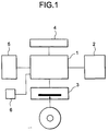
- Fig. 1 shows the construction of a navigation apparatus according to an embodiment of the present invention.
- reference numeral 1 represents a processor comprising a microprocessor and a memory
- reference numeral 2 represents a display device
- reference numeral 3 represents a drive device for accessing a storage medium such as CD-ROM or the like in which map data are stored
- reference numeral 4 represents an input device for accepting an instruction input of a user
- reference numeral 5 represents a sensor device comprising a vehicle-speed sensor, an azimuth sensor, a GPS receiver, etc.
- reference numeral 6 represents a traffic information receiving device for receiving traffic information from a traffic information communication system such as VICS or the like as described above.
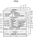
- map data is recorded in a storage medium such as CD-ROM or the like to be loaded in the drive device 3 will be described.
- the map data comprises road data 21 provided for each road, and the road data 21 comprises road information 22 and link information 23.
- the road information 22 contains a road number 26 representing a road uniquely, a road name 24 representing the name of a road, a road type 27 representing the type of road (toll road, national highway, prefectural highway), and other attributes 25 representing other information for the road.
- the link information 23 contains link data 28 representing information of links provided for every link constituting a road.
- link is a line segment used for approximating the shape and position of a road.
- the link data 28 contains a link number 29 representing a link uniquely and a time required 30 corresponding to a value proportional to the length of the link.
- the link data 28 contains node information 31 which is information of a link to be next described, for example, information representing that the node is an interchange or service area of an expressway, an intersection or the like.
- the link data 28 contains, for two nodes at both sides of a link, a node number 32 representing a node uniquely, a node coordinate 35 representing the position of the node, and an adjacent node number list 34 in which the node numbers of all the nodes linked to the node concerned through links are listed.
- the linkage between links is necessarily performed through a node.
- a node is located at the center of the crossroads, and four links are linked to the node at the center.
- the adjacent node number list 34 of the node at the center contains the description of the node numbers of four nodes at the other ends of the four links which are linked to the node concerned.
- the link data 28 contains link shape information 36 specifying the shape of a link.
- the link shape information 36 comprises one or plural sub node coordinates 37.
- the shape of the link is specified as a shape obtained by successively and linearly connecting a first node coordinate of the link, a first sub node coordinate, a second sub node coordinate and a second node coordinate of the link in this order.
- the processor 1 calculates the current position of the vehicle by referring to a vehicle travel azimuth input from the azimuth sensor of the sensor device 5, a vehicle speed input from the vehicle-speed sensor of the sensor device 5 and mesh map data to which the measured current position input from the GPS receiver of the sensor device 5 belongs, and calculates an estimated route from the current position to the destination on the basis of a destination input through the input device 4 by a user and the current position input through the input device 4 by the user or calculated from the input from the sensor device 5.
- the processor 1 controls the drive device 3 to read out the map data on the basis of the current position thus calculated, the travel azimuth of the vehicle and the content indicated through the input device 5 by the user, and displays a map represented by the map data on the display device 2.
- the map display is carried out by displaying a map of an area around the calculated current position on a predetermined reduced scale, displaying a map of a district indicated by the user on a predetermined or indicated reduced scale, or displaying a map covering a region from the current position to the destination in a proper reduced scale together with a searched recommendable route.
- marks representing the current position and the travel azimuth of the vehicle are displayed on the map-while overlaid on the map.
- the estimated travel time calculation processing executed by the processor 1 will be described below.
- Fig. 3 is a flowchart showing the estimated travel time calculation processing.
- the link data 28 of links on a searched recommendable route are checked to select calculation points used to calculate the estimated travel time.
- the calculation points there are selected the destination, and nodes which are described in node information 31 as intersections, interchanges and service areas, or which serve as transfer points between different roads on the recommendable route, among nodes located in a predetermined range from the current position to a position on moving direction (step 301).
- step 302 the estimated travel time required to travel to each calculation point is calculated.
- the calculation of the estimated travel time required is performed as follows.
- the travel time 30 of the link data of each link is weighted with a value corresponding to the road type 27 of the road information of the road data 21 to which the link data 28 concerned belongs, thereby obtaining the static travel time required.
- the link length of each link is calculated on the basis of the link data 28.
- a travel time required to travel between a traffic-jam starting point and a traffic-jam ending point which are represented by traffic-jam information received by the traffic information receiver 6 is taken.
- the travel time represented by the traffic-jam information received by the traffic information receiver 6 represents the current travel time required between the traffic-jam starting point and the traffic-jam ending point which is actually measured.
- X represents the link length of a link 400
- M represents a static travel time calculated for the link 400
- Y represents the length of a part 401 contained in the link 400 of a section between the traffic-jam starting point and the traffic-jam ending point
- N represents a travel time of the part 401 which is calculated on the basis of the travel time received by the traffic information receiver 6.
- the value of the dynamic travel time calculated by the above equation is larger than the static travel time by a predetermined rate or more (two times or more), it is estimated that the reception content of the traffic information receiver 6 may contain an error, and thus the static travel time is directly used as the dynamic travel time.
- the sum of the dynamic travel times calculated for the respective links between the current position and the calculation point is calculated, and it is set as an estimated travel time required to travel from the current point to the calculation point concerned. Further, the total link length calculated from the respective links between the current point and the calculation point is set as a travel distance from the current point to the calculation point (step 303).
- step 304 the sum of the static travel time required for the respective links from the current position to the destination is subtracted from the estimated travel time calculated, and the ratio of the subtraction result to the estimated travel time is calculated as a traffic-jam rate.
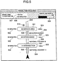
- the travel time required to travel to each calculation point is displayed together with the travel distance to the calculation point concerned as shown in Fig. 5, for example.
- the estimated travel time 502 and the travel distance 503 to each calculation point are displayed at both the right and left sides of the name 501 of each of the interchanges, intersections and services represented by the node information 31 of nodes (excluding the destination) selected as calculation points.
- a road between calculation points is displayed as a line segment 505 connecting the names of the nodes, and the name 504 of the road is displayed on its side.
- a line segment 506 approximately representing a traffic-jam section specified by a traffic-jam starting point and a traffic-jam ending point, the information of which is received by the traffic information receiver, is displayed with every different color on the line segment 505.
- a mark 510 representing a regulation content represented by regulation information received by the traffic information receiver 6 is displayed in the neighborhood of a regulated place.
- the estimated travel time 507 and the travel distance 509 to the destination and a bar graph showing the traffic-jam rate are displayed at the upper side.
- the static travel time is directly used as the dynamic travel time when the dynamic travel time is larger than the static travel time by a predetermined rate or more.
- the predetermined rate for the dynamic travel time of a traffic-jam section containing a traffic-jam place which is estimated to be caused by a traffic regulation may be set to a value larger than that in the other cases. This is because when a traffic jam is caused by a traffic regulation, the dynamic travel time may be large irrespective of a reception error of the traffic information receiver 6.
- the estimated travel time is calculated in consideration of the traffic-jam and traffic regulation information taken from the traffic information communication system. Therefore, even when a traffic jam occurs or traffic regulation is carried out, an estimated travel time conforming more to actual traffic conditions can be calculated.
- the processor 1 may be a computer having a CPU, a memory and a proper OS.
- each process executed by the processor 1 is implemented by the CPU executing a program in which the procedure of each process is described.
- these programs may be supplied to the processor 1 through a storage medium such as a CD-ROM or the like.
- an estimated travel time conforming more to actual traffic conditions can be calculated.
Landscapes
- Engineering & Computer Science (AREA)
- Radar, Positioning & Navigation (AREA)
- Remote Sensing (AREA)
- Automation & Control Theory (AREA)
- General Physics & Mathematics (AREA)
- Physics & Mathematics (AREA)
- Biodiversity & Conservation Biology (AREA)
- Environmental Sciences (AREA)
- Environmental & Geological Engineering (AREA)
- Ecology (AREA)
- Life Sciences & Earth Sciences (AREA)
- Atmospheric Sciences (AREA)
- Navigation (AREA)
- Traffic Control Systems (AREA)
Applications Claiming Priority (2)
| Application Number | Priority Date | Filing Date | Title |
|---|---|---|---|
| JP11893598 | 1998-04-28 | ||
| JP10118935A JPH11311533A (ja) | 1998-04-28 | 1998-04-28 | 経路探索装置 |
Publications (3)
| Publication Number | Publication Date |
|---|---|
| EP0953825A2 true EP0953825A2 (de) | 1999-11-03 |
| EP0953825A3 EP0953825A3 (de) | 2001-03-14 |
| EP0953825B1 EP0953825B1 (de) | 2005-06-15 |
Family
ID=14748877
Family Applications (1)
| Application Number | Title | Priority Date | Filing Date |
|---|---|---|---|
| EP99107441A Expired - Lifetime EP0953825B1 (de) | 1998-04-28 | 1999-04-27 | Routensuchvorrichtung |
Country Status (5)
| Country | Link |
|---|---|
| US (1) | US6438490B2 (de) |
| EP (1) | EP0953825B1 (de) |
| JP (1) | JPH11311533A (de) |
| KR (1) | KR100348953B1 (de) |
| DE (1) | DE69925779T2 (de) |
Cited By (5)
| Publication number | Priority date | Publication date | Assignee | Title |
|---|---|---|---|---|
| EP1215468A2 (de) * | 2000-12-12 | 2002-06-19 | Deutsches Zentrum für Luft- und Raumfahrt | Verfahren zur Repräsentation eines örtlichen und zeitlichen Ablaufs der Bewegung eines Objekts oder Subjekts |
| EP1217331A1 (de) * | 2000-12-20 | 2002-06-26 | Pioneer Corporation | Verfahren und System zum Festlegen der Fahrzeit und darauf beruhendes Verfahren und System zur Routenberechnung |
| EP2168108A4 (de) * | 2007-07-09 | 2012-12-26 | Thinkware Systems Corp | Navigationssystem und verfahren für blockweise führungsgeschwindigkeitsbegrenzungsinformationen |
| EP2341318A3 (de) * | 2009-12-29 | 2013-07-31 | Research In Motion Limited | System und Verfahren zur Darstellung von Routeninformationen |
| DE102004015880B4 (de) * | 2003-04-11 | 2014-10-09 | Xanavi Informatics Corp. | Reisezeit-Berechnungsverfahren und Verkehrsinformationen-Anzeigenverfahren für eine Navigationsvorrichtung |
Families Citing this family (124)
| Publication number | Priority date | Publication date | Assignee | Title |
|---|---|---|---|---|
| US20040215387A1 (en) * | 2002-02-14 | 2004-10-28 | Matsushita Electric Industrial Co., Ltd. | Method for transmitting location information on a digital map, apparatus for implementing the method, and traffic information provision/reception system |
| KR100665470B1 (ko) * | 1999-12-18 | 2007-01-04 | 주식회사 케이티 | 단거리전용통신을 이용한 교통정보 가공방법 및 그를이용한 최적경로 산출방법 |
| US6456234B1 (en) | 2000-06-07 | 2002-09-24 | William J. Johnson | System and method for proactive content delivery by situation location |
| US8060389B2 (en) | 2000-06-07 | 2011-11-15 | Apple Inc. | System and method for anonymous location based services |
| US8489669B2 (en) | 2000-06-07 | 2013-07-16 | Apple Inc. | Mobile data processing system moving interest radius |
| JP5041638B2 (ja) * | 2000-12-08 | 2012-10-03 | パナソニック株式会社 | デジタル地図の位置情報伝達方法とそれに使用する装置 |
| US6615133B2 (en) * | 2001-02-27 | 2003-09-02 | International Business Machines Corporation | Apparatus, system, method and computer program product for determining an optimum route based on historical information |
| JP4391037B2 (ja) * | 2001-04-27 | 2009-12-24 | パイオニア株式会社 | ナビゲーション装置、ナビゲーション方法、及びナビゲーションプログラム |
| US8977284B2 (en) | 2001-10-04 | 2015-03-10 | Traxcell Technologies, LLC | Machine for providing a dynamic data base of geographic location information for a plurality of wireless devices and process for making same |
| KR100837755B1 (ko) * | 2001-11-28 | 2008-06-13 | 주식회사 케이티 | 단거리무선통신 노변기지국의 데이터베이스를 이용한최적경로 안내 방법 |
| US6545637B1 (en) * | 2001-12-20 | 2003-04-08 | Garmin, Ltd. | Systems and methods for a navigational device with improved route calculation capabilities |
| US6546335B1 (en) | 2001-12-21 | 2003-04-08 | Garmin, Ltd. | System, functional data, and methods to bias map matching |
| JP2003240567A (ja) * | 2002-02-13 | 2003-08-27 | Mitsubishi Electric Corp | ナビゲーション装置及びナビゲーション方法 |
| US7221287B2 (en) | 2002-03-05 | 2007-05-22 | Triangle Software Llc | Three-dimensional traffic report |
| JP3883892B2 (ja) * | 2002-03-26 | 2007-02-21 | アルパイン株式会社 | 交通情報配信方法及び車載用ナビゲーション装置 |
| KR100485867B1 (ko) * | 2002-11-13 | 2005-04-28 | 에스케이 주식회사 | 차량의 경로 탐색 시스템 및 그 방법 |
| US7415243B2 (en) | 2003-03-27 | 2008-08-19 | Honda Giken Kogyo Kabushiki Kaisha | System, method and computer program product for receiving data from a satellite radio network |
| WO2005013063A2 (en) | 2003-07-25 | 2005-02-10 | Landsonar, Inc. | System and method for determining recommended departure time |
| US7849149B2 (en) | 2004-04-06 | 2010-12-07 | Honda Motor Co., Ltd. | Method and system for controlling the exchange of vehicle related messages |
| US7818380B2 (en) | 2003-12-15 | 2010-10-19 | Honda Motor Co., Ltd. | Method and system for broadcasting safety messages to a vehicle |
| US8041779B2 (en) | 2003-12-15 | 2011-10-18 | Honda Motor Co., Ltd. | Method and system for facilitating the exchange of information between a vehicle and a remote location |
| JP2005201793A (ja) * | 2004-01-16 | 2005-07-28 | Xanavi Informatics Corp | ナビゲーション装置の経路探索方法 |
| JP2005259116A (ja) * | 2004-02-13 | 2005-09-22 | Matsushita Electric Ind Co Ltd | 交通情報算出装置、交通情報算出方法、交通情報表示方法および交通情報表示装置 |
| JP3907122B2 (ja) * | 2004-03-30 | 2007-04-18 | 本田技研工業株式会社 | 交通情報提供システム |
| US7289904B2 (en) | 2004-04-06 | 2007-10-30 | Honda Motor Co., Ltd. | Vehicle navigation system and methods for incorporating user preferences into same |
| US7319931B2 (en) | 2004-04-06 | 2008-01-15 | Honda Motor Co., Ltd. | Methods for filtering and providing traffic information |
| US7366606B2 (en) | 2004-04-06 | 2008-04-29 | Honda Motor Co., Ltd. | Method for refining traffic flow data |
| US7222018B2 (en) | 2004-04-06 | 2007-05-22 | Honda Motor Co., Ltd. | Bandwidth and memory conserving methods for a vehicle navigation system |
| US7518530B2 (en) | 2004-07-19 | 2009-04-14 | Honda Motor Co., Ltd. | Method and system for broadcasting audio and visual display messages to a vehicle |
| US7643788B2 (en) | 2004-09-22 | 2010-01-05 | Honda Motor Co., Ltd. | Method and system for broadcasting data messages to a vehicle |
| US7162363B2 (en) * | 2004-12-22 | 2007-01-09 | Chinitz Leigh M | Travel route mapping |
| US7894980B2 (en) * | 2005-02-07 | 2011-02-22 | International Business Machines Corporation | Method and apparatus for estimating real-time travel times over a transportation network based on limited real-time data |
| US7562049B2 (en) | 2005-03-29 | 2009-07-14 | Honda Motor Co., Ltd. | Payment system and method for data broadcasted from a remote location to vehicles |
| US7353034B2 (en) | 2005-04-04 | 2008-04-01 | X One, Inc. | Location sharing and tracking using mobile phones or other wireless devices |
| KR20060119739A (ko) * | 2005-05-18 | 2006-11-24 | 엘지전자 주식회사 | 구간 통과시간에 대한 예측정보를 제공하고 이를 이용하는방법 및 장치 |
| KR20060119746A (ko) * | 2005-05-18 | 2006-11-24 | 엘지전자 주식회사 | 교통상태에 대한 정보를 제공하고 이를 이용하는 방법 및장치 |
| KR20060119742A (ko) * | 2005-05-18 | 2006-11-24 | 엘지전자 주식회사 | 도로 정보를 제공하고 이를 이용하는 방법 및 장치 |
| KR20060119743A (ko) * | 2005-05-18 | 2006-11-24 | 엘지전자 주식회사 | 구간 속도에 대한 예측정보를 제공하고 이를 이용하는 방법및 장치 |
| US7729335B2 (en) * | 2005-05-18 | 2010-06-01 | Lg Electronics Inc. | Providing traffic information relating to a prediction of congestion status and using the same |
| KR20060119741A (ko) * | 2005-05-18 | 2006-11-24 | 엘지전자 주식회사 | 소통상태의 추이정보를 제공하고 이를 이용하는 방법 및장치 |
| KR100711866B1 (ko) * | 2005-05-18 | 2007-04-25 | 엘지전자 주식회사 | 소통상태에 대한 예측정보를 제공하고 이를 이용하는 방법및 장치 |
| KR20060122668A (ko) * | 2005-05-27 | 2006-11-30 | 엘지전자 주식회사 | 교통 정보 제공 방법 및 수신 장치 |
| JP2007011558A (ja) * | 2005-06-29 | 2007-01-18 | Nissan Motor Co Ltd | 渋滞予測装置および方法 |
| US8711850B2 (en) * | 2005-07-08 | 2014-04-29 | Lg Electronics Inc. | Format for providing traffic information and a method and apparatus for using the format |
| US7949330B2 (en) | 2005-08-25 | 2011-05-24 | Honda Motor Co., Ltd. | System and method for providing weather warnings and alerts |
| KR101254219B1 (ko) * | 2006-01-19 | 2013-04-23 | 엘지전자 주식회사 | 링크 식별 방법 및 링크 식별 장치 |
| US8046162B2 (en) | 2005-11-04 | 2011-10-25 | Honda Motor Co., Ltd. | Data broadcast method for traffic information |
| US7472169B2 (en) * | 2006-03-15 | 2008-12-30 | Traffic.Com, Inc. | Method of displaying traffic information on a web page |
| US7203595B1 (en) * | 2006-03-15 | 2007-04-10 | Traffic.Com, Inc. | Rating that represents the status along a specified driving route |
| EP1921421A1 (de) * | 2006-11-10 | 2008-05-14 | Harman Becker Automotive Systems GmbH | Verfahren und Vorrichtung zur Bereitstellung von Reisezeitinformation |
| US7668653B2 (en) | 2007-05-31 | 2010-02-23 | Honda Motor Co., Ltd. | System and method for selectively filtering and providing event program information |
| US8275352B2 (en) | 2007-06-28 | 2012-09-25 | Apple Inc. | Location-based emergency information |
| US8175802B2 (en) | 2007-06-28 | 2012-05-08 | Apple Inc. | Adaptive route guidance based on preferences |
| US8311526B2 (en) | 2007-06-28 | 2012-11-13 | Apple Inc. | Location-based categorical information services |
| US8762056B2 (en) | 2007-06-28 | 2014-06-24 | Apple Inc. | Route reference |
| US8108144B2 (en) | 2007-06-28 | 2012-01-31 | Apple Inc. | Location based tracking |
| US9109904B2 (en) | 2007-06-28 | 2015-08-18 | Apple Inc. | Integration of map services and user applications in a mobile device |
| US8774825B2 (en) | 2007-06-28 | 2014-07-08 | Apple Inc. | Integration of map services with user applications in a mobile device |
| US9066199B2 (en) | 2007-06-28 | 2015-06-23 | Apple Inc. | Location-aware mobile device |
| US8204684B2 (en) | 2007-06-28 | 2012-06-19 | Apple Inc. | Adaptive mobile device navigation |
| US8332402B2 (en) | 2007-06-28 | 2012-12-11 | Apple Inc. | Location based media items |
| US8385946B2 (en) | 2007-06-28 | 2013-02-26 | Apple Inc. | Disfavored route progressions or locations |
| US8290513B2 (en) | 2007-06-28 | 2012-10-16 | Apple Inc. | Location-based services |
| US7920961B2 (en) * | 2007-08-29 | 2011-04-05 | Sap Ag | Method and apparatus for path planning and distance calculation |
| US8290699B2 (en) * | 2007-09-28 | 2012-10-16 | Clarion Co., Ltd. | System and method for geographic interpolation of traffic data |
| US8099308B2 (en) | 2007-10-02 | 2012-01-17 | Honda Motor Co., Ltd. | Method and system for vehicle service appointments based on diagnostic trouble codes |
| US8892112B2 (en) | 2011-07-21 | 2014-11-18 | At&T Mobility Ii Llc | Selection of a radio access bearer resource based on radio access bearer resource historical information |
| US8977294B2 (en) | 2007-10-10 | 2015-03-10 | Apple Inc. | Securely locating a device |
| US8355862B2 (en) | 2008-01-06 | 2013-01-15 | Apple Inc. | Graphical user interface for presenting location information |
| US20090265091A1 (en) * | 2008-04-16 | 2009-10-22 | Xanavi Informatics Corporation | Method and apparatus utilizing both statistical and real time data for a vehicle navigation system |
| US9250092B2 (en) | 2008-05-12 | 2016-02-02 | Apple Inc. | Map service with network-based query for search |
| US8644843B2 (en) | 2008-05-16 | 2014-02-04 | Apple Inc. | Location determination |
| JP5330508B2 (ja) * | 2008-06-25 | 2013-10-30 | トムトム インターナショナル ベスローテン フエンノートシャップ | ナビゲーション装置、ナビゲーション装置の制御方法、プログラム及び媒体 |
| US8369867B2 (en) | 2008-06-30 | 2013-02-05 | Apple Inc. | Location sharing |
| JP5271637B2 (ja) * | 2008-08-28 | 2013-08-21 | アイシン・エィ・ダブリュ株式会社 | 走行経路評価システム及び走行経路評価プログラム |
| US8359643B2 (en) | 2008-09-18 | 2013-01-22 | Apple Inc. | Group formation using anonymous broadcast information |
| US8260320B2 (en) | 2008-11-13 | 2012-09-04 | Apple Inc. | Location specific content |
| US8326319B2 (en) * | 2009-01-23 | 2012-12-04 | At&T Mobility Ii Llc | Compensation of propagation delays of wireless signals |
| US9046924B2 (en) | 2009-03-04 | 2015-06-02 | Pelmorex Canada Inc. | Gesture based interaction with traffic data |
| US8982116B2 (en) | 2009-03-04 | 2015-03-17 | Pelmorex Canada Inc. | Touch screen based interaction with traffic data |
| US8619072B2 (en) | 2009-03-04 | 2013-12-31 | Triangle Software Llc | Controlling a three-dimensional virtual broadcast presentation |
| US8670748B2 (en) | 2009-05-01 | 2014-03-11 | Apple Inc. | Remotely locating and commanding a mobile device |
| US8660530B2 (en) | 2009-05-01 | 2014-02-25 | Apple Inc. | Remotely receiving and communicating commands to a mobile device for execution by the mobile device |
| US8666367B2 (en) | 2009-05-01 | 2014-03-04 | Apple Inc. | Remotely locating and commanding a mobile device |
| US8224349B2 (en) * | 2010-02-25 | 2012-07-17 | At&T Mobility Ii Llc | Timed fingerprint locating in wireless networks |
| US8254959B2 (en) * | 2010-02-25 | 2012-08-28 | At&T Mobility Ii Llc | Timed fingerprint locating for idle-state user equipment in wireless networks |
| US9053513B2 (en) | 2010-02-25 | 2015-06-09 | At&T Mobility Ii Llc | Fraud analysis for a location aware transaction |
| US9008684B2 (en) | 2010-02-25 | 2015-04-14 | At&T Mobility Ii Llc | Sharing timed fingerprint location information |
| US8566035B2 (en) * | 2010-02-25 | 2013-10-22 | International Business Machines Corporation | Route optimization |
| US9196157B2 (en) | 2010-02-25 | 2015-11-24 | AT&T Mobolity II LLC | Transportation analytics employing timed fingerprint location information |
| US8447328B2 (en) | 2010-08-27 | 2013-05-21 | At&T Mobility Ii Llc | Location estimation of a mobile device in a UMTS network |
| CA2823827C (en) | 2010-11-14 | 2018-08-28 | Triangle Software Llc | Crowd sourced traffic reporting |
| US9009629B2 (en) | 2010-12-01 | 2015-04-14 | At&T Mobility Ii Llc | Motion-based user interface feature subsets |
| US8509806B2 (en) | 2010-12-14 | 2013-08-13 | At&T Intellectual Property I, L.P. | Classifying the position of a wireless device |
| US8725396B2 (en) | 2011-05-18 | 2014-05-13 | Pelmorex Canada Inc. | System for providing traffic data and driving efficiency data |
| US8612410B2 (en) | 2011-06-30 | 2013-12-17 | At&T Mobility Ii Llc | Dynamic content selection through timed fingerprint location data |
| US9462497B2 (en) | 2011-07-01 | 2016-10-04 | At&T Mobility Ii Llc | Subscriber data analysis and graphical rendering |
| US8761799B2 (en) | 2011-07-21 | 2014-06-24 | At&T Mobility Ii Llc | Location analytics employing timed fingerprint location information |
| US9519043B2 (en) | 2011-07-21 | 2016-12-13 | At&T Mobility Ii Llc | Estimating network based locating error in wireless networks |
| US8897802B2 (en) | 2011-07-21 | 2014-11-25 | At&T Mobility Ii Llc | Selection of a radio access technology resource based on radio access technology resource historical information |
| US8923134B2 (en) | 2011-08-29 | 2014-12-30 | At&T Mobility Ii Llc | Prioritizing network failure tickets using mobile location data |
| US8666390B2 (en) | 2011-08-29 | 2014-03-04 | At&T Mobility Ii Llc | Ticketing mobile call failures based on geolocated event data |
| US8762048B2 (en) | 2011-10-28 | 2014-06-24 | At&T Mobility Ii Llc | Automatic travel time and routing determinations in a wireless network |
| US8909247B2 (en) | 2011-11-08 | 2014-12-09 | At&T Mobility Ii Llc | Location based sharing of a network access credential |
| US9026133B2 (en) | 2011-11-28 | 2015-05-05 | At&T Mobility Ii Llc | Handset agent calibration for timing based locating systems |
| US8970432B2 (en) | 2011-11-28 | 2015-03-03 | At&T Mobility Ii Llc | Femtocell calibration for timing based locating systems |
| CA2883973C (en) | 2012-01-27 | 2021-02-23 | Edgar Rojas | Estimating time travel distributions on signalized arterials |
| US8925104B2 (en) | 2012-04-13 | 2014-12-30 | At&T Mobility Ii Llc | Event driven permissive sharing of information |
| US8929827B2 (en) | 2012-06-04 | 2015-01-06 | At&T Mobility Ii Llc | Adaptive calibration of measurements for a wireless radio network |
| US9094929B2 (en) | 2012-06-12 | 2015-07-28 | At&T Mobility Ii Llc | Event tagging for mobile networks |
| US9326263B2 (en) | 2012-06-13 | 2016-04-26 | At&T Mobility Ii Llc | Site location determination using crowd sourced propagation delay and location data |
| US9046592B2 (en) | 2012-06-13 | 2015-06-02 | At&T Mobility Ii Llc | Timed fingerprint locating at user equipment |
| US8938258B2 (en) | 2012-06-14 | 2015-01-20 | At&T Mobility Ii Llc | Reference based location information for a wireless network |
| US8897805B2 (en) | 2012-06-15 | 2014-11-25 | At&T Intellectual Property I, L.P. | Geographic redundancy determination for time based location information in a wireless radio network |
| US9408174B2 (en) | 2012-06-19 | 2016-08-02 | At&T Mobility Ii Llc | Facilitation of timed fingerprint mobile device locating |
| US8855901B2 (en) | 2012-06-25 | 2014-10-07 | Google Inc. | Providing route recommendations |
| US8892054B2 (en) | 2012-07-17 | 2014-11-18 | At&T Mobility Ii Llc | Facilitation of delay error correction in timing-based location systems |
| US9351223B2 (en) | 2012-07-25 | 2016-05-24 | At&T Mobility Ii Llc | Assignment of hierarchical cell structures employing geolocation techniques |
| US10223909B2 (en) | 2012-10-18 | 2019-03-05 | Uber Technologies, Inc. | Estimating time travel distributions on signalized arterials |
| JP6295508B2 (ja) * | 2013-01-31 | 2018-03-20 | 株式会社Jvcケンウッド | ナビゲーション装置、ナビゲーション方法、及びプログラム |
| US20150106006A1 (en) * | 2013-10-11 | 2015-04-16 | Kevin NAJAFI | Method of route scheduling and devices thereof |
| US9351111B1 (en) | 2015-03-06 | 2016-05-24 | At&T Mobility Ii Llc | Access to mobile location related information |
| US10516972B1 (en) | 2018-06-01 | 2019-12-24 | At&T Intellectual Property I, L.P. | Employing an alternate identifier for subscription access to mobile location information |
| CN114743398B (zh) * | 2022-03-15 | 2023-09-19 | 南方科技大学 | 拥塞可容忍的路径引导方法及装置、设备及存储介质 |
Citations (3)
| Publication number | Priority date | Publication date | Assignee | Title |
|---|---|---|---|---|
| EP0622611A1 (de) * | 1993-04-26 | 1994-11-02 | Pioneer Electronic Corporation | Navigationsvorrichtung |
| EP0660289A1 (de) * | 1993-12-27 | 1995-06-28 | Aisin Aw Co., Ltd. | Kartenanzeigesystem |
| US5694122A (en) * | 1995-11-17 | 1997-12-02 | Matsushita Electric Industrial Co., Ltd. | Jam information display using an arrow whose attribute value changes from a jam tail to a jam head |
Family Cites Families (14)
| Publication number | Priority date | Publication date | Assignee | Title |
|---|---|---|---|---|
| DE4008460A1 (de) * | 1990-03-16 | 1991-09-19 | Bosch Gmbh Robert | Navigationssystem |
| JPH04188181A (ja) * | 1990-11-22 | 1992-07-06 | Nissan Motor Co Ltd | 車両用経路検索装置 |
| US5845227A (en) * | 1991-02-01 | 1998-12-01 | Peterson; Thomas D. | Method and apparatus for providing shortest elapsed time route and tracking information to users |
| US5272638A (en) * | 1991-05-31 | 1993-12-21 | Texas Instruments Incorporated | Systems and methods for planning the scheduling travel routes |
| JP2771911B2 (ja) * | 1991-08-09 | 1998-07-02 | 三菱電機株式会社 | 車載用ナビゲーション装置 |
| JP2999339B2 (ja) * | 1993-01-11 | 2000-01-17 | 三菱電機株式会社 | 車両用経路案内装置 |
| JP3385657B2 (ja) * | 1993-08-10 | 2003-03-10 | トヨタ自動車株式会社 | 車載用ナビゲーション装置 |
| ES2140713T3 (es) * | 1994-10-07 | 2000-03-01 | Mannesmann Ag | Introduccion del destino para un sistema de navegacion. |
| JPH08220246A (ja) | 1995-02-10 | 1996-08-30 | Yasuhiro Umemoto | 危険性が高い地震を知らせる報知機 |
| US5911773A (en) * | 1995-07-24 | 1999-06-15 | Aisin Aw Co., Ltd. | Navigation system for vehicles |
| US5774827A (en) * | 1996-04-03 | 1998-06-30 | Motorola Inc. | Commuter route selection system |
| JPH1063728A (ja) * | 1996-08-22 | 1998-03-06 | Hitachi Ltd | 携帯情報端末による運行スケジュール連携方法及び装置 |
| JPH1082647A (ja) * | 1996-09-05 | 1998-03-31 | Mitsubishi Electric Corp | 移動体用ナビゲーション装置 |
| US5862509A (en) * | 1996-12-20 | 1999-01-19 | Zexel Corporation | Vehicle navigation using timed turn and timed lane restrictions |
-
1998
- 1998-04-28 JP JP10118935A patent/JPH11311533A/ja active Pending
-
1999
- 1999-04-27 DE DE69925779T patent/DE69925779T2/de not_active Expired - Lifetime
- 1999-04-27 KR KR1019990014982A patent/KR100348953B1/ko not_active IP Right Cessation
- 1999-04-27 US US09/300,606 patent/US6438490B2/en not_active Expired - Lifetime
- 1999-04-27 EP EP99107441A patent/EP0953825B1/de not_active Expired - Lifetime
Patent Citations (3)
| Publication number | Priority date | Publication date | Assignee | Title |
|---|---|---|---|---|
| EP0622611A1 (de) * | 1993-04-26 | 1994-11-02 | Pioneer Electronic Corporation | Navigationsvorrichtung |
| EP0660289A1 (de) * | 1993-12-27 | 1995-06-28 | Aisin Aw Co., Ltd. | Kartenanzeigesystem |
| US5694122A (en) * | 1995-11-17 | 1997-12-02 | Matsushita Electric Industrial Co., Ltd. | Jam information display using an arrow whose attribute value changes from a jam tail to a jam head |
Cited By (10)
| Publication number | Priority date | Publication date | Assignee | Title |
|---|---|---|---|---|
| EP1215468A2 (de) * | 2000-12-12 | 2002-06-19 | Deutsches Zentrum für Luft- und Raumfahrt | Verfahren zur Repräsentation eines örtlichen und zeitlichen Ablaufs der Bewegung eines Objekts oder Subjekts |
| DE10061865A1 (de) * | 2000-12-12 | 2002-06-27 | Deutsch Zentr Luft & Raumfahrt | Verfahren zur Repräsentation eines örtlichen und zeitlichen Ablaufs der Bewegung eines Objekts oder Subjekts |
| DE10061865C2 (de) * | 2000-12-12 | 2002-10-24 | Deutsch Zentr Luft & Raumfahrt | Verfahren zur Repräsentation eines örtlichen und zeitlichen Ablaufs der Bewegung eines Objekts oder Subjekts |
| EP1215468A3 (de) * | 2000-12-12 | 2002-11-20 | Deutsches Zentrum für Luft- und Raumfahrt | Verfahren zur Repräsentation eines örtlichen und zeitlichen Ablaufs der Bewegung eines Objekts oder Subjekts |
| EP1217331A1 (de) * | 2000-12-20 | 2002-06-26 | Pioneer Corporation | Verfahren und System zum Festlegen der Fahrzeit und darauf beruhendes Verfahren und System zur Routenberechnung |
| US6915207B2 (en) | 2000-12-20 | 2005-07-05 | Pioneer Corporation | Method and system for setting travel time and method and system for route calculation with use thereof |
| DE102004015880B4 (de) * | 2003-04-11 | 2014-10-09 | Xanavi Informatics Corp. | Reisezeit-Berechnungsverfahren und Verkehrsinformationen-Anzeigenverfahren für eine Navigationsvorrichtung |
| EP2168108A4 (de) * | 2007-07-09 | 2012-12-26 | Thinkware Systems Corp | Navigationssystem und verfahren für blockweise führungsgeschwindigkeitsbegrenzungsinformationen |
| EP2341318A3 (de) * | 2009-12-29 | 2013-07-31 | Research In Motion Limited | System und Verfahren zur Darstellung von Routeninformationen |
| US8924142B2 (en) | 2009-12-29 | 2014-12-30 | Blackberry Limited | System and method of representing route information |
Also Published As
| Publication number | Publication date |
|---|---|
| JPH11311533A (ja) | 1999-11-09 |
| KR100348953B1 (ko) | 2002-08-17 |
| DE69925779D1 (de) | 2005-07-21 |
| EP0953825A3 (de) | 2001-03-14 |
| US20010047242A1 (en) | 2001-11-29 |
| DE69925779T2 (de) | 2005-12-15 |
| KR19990083509A (ko) | 1999-11-25 |
| US6438490B2 (en) | 2002-08-20 |
| EP0953825B1 (de) | 2005-06-15 |
Similar Documents
| Publication | Publication Date | Title |
|---|---|---|
| EP0953825B1 (de) | Routensuchvorrichtung | |
| US7251561B2 (en) | Selective download of corridor map data | |
| US5905451A (en) | Vehicular navigation system | |
| EP0955520B1 (de) | Routensuchvorrichtung | |
| JP3754110B2 (ja) | 動的経路探索方法およびナビゲーション装置 | |
| WO2004031690A1 (ja) | 地図データ送信方法、情報配信装置、および情報端末 | |
| US8494769B2 (en) | Information system, terminal device, and information center device | |
| US7844393B2 (en) | Vehicle navigation system and method | |
| JP4502335B2 (ja) | 地図表示システム、端末装置、地図表示サーバ及び地図表示方法 | |
| JP2006350953A (ja) | カーナビゲーション装置 | |
| JP3566503B2 (ja) | リンク旅行時間補間方法 | |
| JP4152478B2 (ja) | 経路探索装置、経路探索方法、および、記憶媒体 | |
| JPH08138194A (ja) | 道路交通情報システム | |
| JP3443246B2 (ja) | 車載用ナビゲーション装置 | |
| JP4023128B2 (ja) | ナビゲーションシステム及びプログラム | |
| JP3319084B2 (ja) | 走行経路案内装置 | |
| JP3275673B2 (ja) | 走行経路案内装置 | |
| JP2004037301A (ja) | 旅行時間算出装置及びナビゲーションシステム | |
| JP3951790B2 (ja) | ナビゲーション装置、経路表示方法、記憶媒体 | |
| JPH0996539A (ja) | 車両用ナビゲーション装置 | |
| JP4198781B2 (ja) | 経路探索装置 | |
| JP4546514B2 (ja) | ナビゲーション装置、その所要時間算出方法 | |
| JP4152479B2 (ja) | 路線情報提示装置とその方法および記憶媒体 | |
| JP3732350B2 (ja) | 車載用ナビゲーション装置の交通情報表示方法 | |
| JP3573618B2 (ja) | 経路探索装置 |
Legal Events
| Date | Code | Title | Description |
|---|---|---|---|
| PUAI | Public reference made under article 153(3) epc to a published international application that has entered the european phase |
Free format text: ORIGINAL CODE: 0009012 |
|
| 17P | Request for examination filed |
Effective date: 19990427 |
|
| AK | Designated contracting states |
Kind code of ref document: A2 Designated state(s): DE FR GB |
|
| AX | Request for extension of the european patent |
Free format text: AL;LT;LV;MK;RO;SI |
|
| PUAL | Search report despatched |
Free format text: ORIGINAL CODE: 0009013 |
|
| AK | Designated contracting states |
Kind code of ref document: A3 Designated state(s): AT BE CH CY DE DK ES FI FR GB GR IE IT LI LU MC NL PT SE |
|
| AX | Request for extension of the european patent |
Free format text: AL;LT;LV;MK;RO;SI |
|
| AKX | Designation fees paid |
Free format text: DE FR GB |
|
| 17Q | First examination report despatched |
Effective date: 20040702 |
|
| GRAP | Despatch of communication of intention to grant a patent |
Free format text: ORIGINAL CODE: EPIDOSNIGR1 |
|
| GRAS | Grant fee paid |
Free format text: ORIGINAL CODE: EPIDOSNIGR3 |
|
| GRAA | (expected) grant |
Free format text: ORIGINAL CODE: 0009210 |
|
| AK | Designated contracting states |
Kind code of ref document: B1 Designated state(s): DE FR GB |
|
| REG | Reference to a national code |
Ref country code: GB Ref legal event code: FG4D |
|
| REF | Corresponds to: |
Ref document number: 69925779 Country of ref document: DE Date of ref document: 20050721 Kind code of ref document: P |
|
| PG25 | Lapsed in a contracting state [announced via postgrant information from national office to epo] |
Ref country code: GB Free format text: LAPSE BECAUSE OF NON-PAYMENT OF DUE FEES Effective date: 20060427 |
|
| PLBE | No opposition filed within time limit |
Free format text: ORIGINAL CODE: 0009261 |
|
| STAA | Information on the status of an ep patent application or granted ep patent |
Free format text: STATUS: NO OPPOSITION FILED WITHIN TIME LIMIT |
|
| 26N | No opposition filed |
Effective date: 20060316 |
|
| EN | Fr: translation not filed | ||
| PG25 | Lapsed in a contracting state [announced via postgrant information from national office to epo] |
Ref country code: FR Free format text: LAPSE BECAUSE OF FAILURE TO SUBMIT A TRANSLATION OF THE DESCRIPTION OR TO PAY THE FEE WITHIN THE PRESCRIBED TIME-LIMIT Effective date: 20060811 |
|
| GBPC | Gb: european patent ceased through non-payment of renewal fee |
Effective date: 20060427 |
|
| PG25 | Lapsed in a contracting state [announced via postgrant information from national office to epo] |
Ref country code: FR Free format text: LAPSE BECAUSE OF FAILURE TO SUBMIT A TRANSLATION OF THE DESCRIPTION OR TO PAY THE FEE WITHIN THE PRESCRIBED TIME-LIMIT Effective date: 20050615 |
|
| REG | Reference to a national code |
Ref country code: DE Ref legal event code: R082 Ref document number: 69925779 Country of ref document: DE Representative=s name: BARDEHLE PAGENBERG PARTNERSCHAFT MBB PATENTANW, DE |
|
| REG | Reference to a national code |
Ref country code: DE Ref legal event code: R082 Ref document number: 69925779 Country of ref document: DE Representative=s name: BARDEHLE PAGENBERG PARTNERSCHAFT MBB PATENTANW, DE Effective date: 20140311 Ref country code: DE Ref legal event code: R081 Ref document number: 69925779 Country of ref document: DE Owner name: CLARION CO., LTD., SAITAMA-SHI, JP Free format text: FORMER OWNER: XANAVI INFORMATICS CORP., ZAMA-SHI, KANAGAWA, JP Effective date: 20140311 Ref country code: DE Ref legal event code: R081 Ref document number: 69925779 Country of ref document: DE Owner name: CLARION CO., LTD., JP Free format text: FORMER OWNER: XANAVI INFORMATICS CORP., ZAMA-SHI, JP Effective date: 20140311 |
|
| PGFP | Annual fee paid to national office [announced via postgrant information from national office to epo] |
Ref country code: DE Payment date: 20160419 Year of fee payment: 18 |
|
| REG | Reference to a national code |
Ref country code: DE Ref legal event code: R119 Ref document number: 69925779 Country of ref document: DE |
|
| PG25 | Lapsed in a contracting state [announced via postgrant information from national office to epo] |
Ref country code: DE Free format text: LAPSE BECAUSE OF NON-PAYMENT OF DUE FEES Effective date: 20171103 |