EP0866311A2 - Method for displaying directional information of a navigation system - Google Patents
Method for displaying directional information of a navigation system Download PDFInfo
- Publication number
- EP0866311A2 EP0866311A2 EP98200726A EP98200726A EP0866311A2 EP 0866311 A2 EP0866311 A2 EP 0866311A2 EP 98200726 A EP98200726 A EP 98200726A EP 98200726 A EP98200726 A EP 98200726A EP 0866311 A2 EP0866311 A2 EP 0866311A2
- Authority
- EP
- European Patent Office
- Prior art keywords
- distance
- directional
- vehicle position
- vehicle
- route
- Prior art date
- Legal status (The legal status is an assumption and is not a legal conclusion. Google has not performed a legal analysis and makes no representation as to the accuracy of the status listed.)
- Granted
Links
Images

Classifications
-
- G—PHYSICS
- G01—MEASURING; TESTING
- G01C—MEASURING DISTANCES, LEVELS OR BEARINGS; SURVEYING; NAVIGATION; GYROSCOPIC INSTRUMENTS; PHOTOGRAMMETRY OR VIDEOGRAMMETRY
- G01C21/00—Navigation; Navigational instruments not provided for in groups G01C1/00 - G01C19/00
- G01C21/26—Navigation; Navigational instruments not provided for in groups G01C1/00 - G01C19/00 specially adapted for navigation in a road network
- G01C21/34—Route searching; Route guidance
- G01C21/36—Input/output arrangements for on-board computers
- G01C21/3626—Details of the output of route guidance instructions
- G01C21/3632—Guidance using simplified or iconic instructions, e.g. using arrows
Definitions
- Such a method for output of directional information as well as a Such a navigation system is known for example from EP 534 533 A1.
- the direction information is in the form of abstracted intersection displays.
- the display of the abstracted Intersection representations are particularly suitable for fully digitized areas, i.e. for areas in which every single street of this area in the map memory of the Navigation system is saved. This is especially true for larger cities. Smaller cities and rural areas are in the map memory of the However, the navigation system is often only partially digitized, i.e. Not every street in this area is recorded in the memory of the navigation system. On Crossroads or road junctions that are not from the store of the Navigation system are detected, it can therefore be one with a driver vehicle equipped with such a navigation system for basic clarifications or Misunderstandings arise regarding the route to be traveled.
- a map of the surroundings can be shown in the abstracted intersection display is provided in particular for orientation in partially digitized areas.
- To one To be able to represent such a map of the area satisfactorily is a high resolution screen required.
- This object is achieved for a method in that a first Direction indicator to show the direct direction from a current one Vehicle position to a lying on the route by a distance a distance point is provided along the planned route, the Distance point is continuously adjusted depending on the vehicle position.
- the first direction indicator is used to show the planned direction in the close surroundings of the current vehicle position.
- the direct Direction i.e. the direction along the straight line from the current one Vehicle position to a distance point on the route is displayed.
- the distance point is in the direction of travel before the current vehicle position and is a respective distance traveled, i.e. the route along the planned Road or route, from the current vehicle position. During the journey, the distance point becomes the vehicle's position changes moved and thus adapted to the vehicle position.
- the distance point is preferably on the order of approximately 50 m to approx. 500 m along the planned route from the current vehicle position away.
- the first directional display enables particularly in partially digitized areas a constant, continuous display of those planned in the immediate vicinity Direction of travel. In case of doubtful crossings, the user can see the Recognize the planned direction and continue the journey in the right direction.
- the first direction indicator enables the driver to continuously Directional information, even if there is no active information. e.g. that he was at one Turn should be present.
- the first direction display can be very easily e.g. in the form of a straight line Represent arrow or in the form of a compass needle.
- the first Direction indication also on simple displays or screens, e.g. on Realize monochrome screens.
- a variation of the distance traveled enables the distance traveled to be displayed various parameters, e.g. Vehicle parameters, environmental parameters and Road parameters, adjust and thereby the first directional display for the Optimize users.
- a further advantageous embodiment of the invention is characterized by the Features of claim 4.
- the type of roadway is understood to mean the respective classification under which the individual streets in the map memory of the navigation system are classified.
- Classification types are e.g. Motorways, federal highways, state roads, Side streets and the like are provided.
- the higher the expected Average speed on the respective lane type is the greater advantageously selected the distance traveled for this type of road. So is for example, a high average speed can be expected on motorways. and the course of a freeway usually shows few curves on. It is therefore advantageous to have a long distance for highways to provide. In contrast, there is a smaller one on a small side street Average speed and a significantly more curvy course of the Lane expected. Therefore, it is advantageous for the road type of secondary road to provide a shorter distance.
- it is advantageous for individual lane types of the navigation system stored in the map memory to provide a guideline for the distance traveled and this depending to change the vehicle speed.
- the optimal value of the distance traveled is strongly dependent on the course of the road dependent. By changing the distance depending on the road surface this and thus the respective direction indicator for the respective lane course be optimized. In the case of special curve geometries in particular, it makes sense to use the Distance distance to choose relatively small. This can be done through a automatic adaptation of the distance traveled depending on the Lane course can be realized.
- Another option is to change the course of the road between the evaluate the current vehicle position and the current distance point. For this purpose it is provided on the distance between the current one Vehicle position and the current distance point in each case in equidistant Distances to set sub-distance points and to these sub-distance points respective angle of the first directional display with respect to the current one Calculate vehicle position. Exceeds the angular difference between them a predefined limit value for each calculated angle, it will automatically the distance traveled is reduced.
- predefinable intersection geometries to provide predeterminable distance routes.
- Intersection geometers are then passed through the respective Intersection of the predefinable distance routes for the first direction display used.
- the predeterminable intersection geometries can be recognized for example by means of a pattern recognition algorithm. It is also advantageous to vary the distance traveled depending on the To change the road surface.
- Another advantageous embodiment of the method according to the invention is characterized in that the distance traveled depending on the light and / or Visibility is changeable.
- the distance can be dipped or High beam range can be adjusted so that the distance point within the Visibility of the driver is. It is also possible to show the distance traveled other restrictions on visibility, e.g. in fog.
- the brightness sensors are e.g. Photo diodes can be used. It is also possible the switch for the low or high beam of the vehicle as a brightness sensor use, and depending on whether the high beam, the low beam or even no light is switched on, to set a predefinable distance.
- Such a combination of the first and the second direction indicator enables depending on the card information available optimal direction indicator.
- the software of the respective navigation system recognizes automatically whether the map information for the respective vehicle position in partially digitized or fully digitized form. Are the dates in partially digitized form, so the first directional display is preferably displayed, while in fully digitized environments the second direction indicator is provided. Sometimes it can also work in fully digitized environments to be advantageous, in addition to the abstract crossing representation, the first Direction display to be provided.
- Such a straight-ahead arrow signals to the user that the navigation system currently has no direction changes for him and that he should follow the current course of the road.
- unclear situations e.g. if in a non-digitized turn occurs on a sharp curve, the user can recognize how he should drive from the first direction indicator.
- the computing circuit uses the sensor signal to calculate the current one Position of the vehicle.
- a distance point is determined by the arithmetic circuit, which is one Distance traveled along the planned route in the direction of travel from current vehicle position is removed.
- the arithmetic circuit calculates as first direction information the direct direction, i.e. the direction along the Air line from the current vehicle position to the distance point.
- This first Direction information is sent from the arithmetic circuit to the output device supplied, which visually shows the first direction indicator.
- the arithmetic circuit is provided to vary the distance traveled.
- a variation of the distance traveled enables the distance traveled to be displayed various parameters, e.g. Vehicle parameters, environmental parameters and Road parameters, adjust and thereby the first directional display for the Optimize users.
- the optimal value of the distance traveled is strongly dependent on the course of the road dependent and can be carried out by a software in the arithmetic circuit automatic adjustment of the distance traveled can be set.
- a software in the arithmetic circuit automatic adjustment of the distance traveled can be set.
- a pattern recognition algorithm in the arithmetic circuit is implemented, which is automatically recognized when predeterminable Intersection geometries, e.g. in a memory of the navigation system distance journeys used.
- Another option is that the stored in a map storage unit of the navigation system Map information for predeterminable intersections or road courses as Additional information in each case for this intersection or this course of the road have optimal distance routes.
- a default value for the distance traveled can be specified by a user. With such a default value that can be entered by the user, anyone Adjust the first direction indicator to the driver's individual needs.
- Another advantageous embodiment of the navigation system is characterized by the feature of claim 9.
- Such a combination of the first and the second directional display makes it possible, depending on the map information available in the map storage unit of the navigation system, to offer the user an optimal directional display.
- the software of the arithmetic circuit automatically recognizes whether the card information supplied by the card storage unit for the respective vehicle position is available in partially digitized or fully digitized form. If the data is in partially digitized form, the computing circuit preferably delivers the first direction information to the output device, and the first direction indicator is displayed by the output device, while the second direction indicator is provided in fully digitized environments. In some cases, it can also be advantageous in fully digitized environments to display the first directional display in addition to the abstracted intersection by means of the output device.
- the first directional display can be displayed very easily, for example in the form of a straight arrow or in the form of a compass needle. Therefore, the first directional display can also be shown on screens with a low resolution, for example on monochrome screens with a resolution of 64x120 pixels. This enables very inexpensive navigation systems to be implemented.
- Such a display can be arranged in the driver's field of vision. Using such a display, the driver can quickly record the first directional information without having to take his eyes off the road.
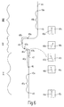
- Fig. 1 shows a block diagram of an embodiment of an inventive Navigation system in which the method according to the invention is implemented.
- the navigation system shown in FIG. 1 has a central element Computing circuit 1, which with an operating device 2, a Card storage unit 3, an RDS / TMC receiver 4 and a GSM module 5 is coupled.
- the control device 2 can, for example, by means of a keyboard, a trackball or a touch-sensitive screen (touch screen) will be realized.
- the card storage unit 3 can, for example, by means of a CD-ROM drive can be realized, the card information on a or several CD-ROMs are stored.
- the RDS / TMC receiver 4 is used the reception of traffic information.
- both Traffic information that is transmitted according to the GSM standard is received be made as well as phone calls.
- An output device 6 which has an optical output module 7 and comprises an acoustic output module 8. Both the optical output module 7 and the acoustic output module 8 are also coupled to the computing circuit 1. It a sensor unit 9 is provided, the wheel sensors 10, an electronic one Compass 11 and a GPS receiver unit 12. The wheel sensors 10, the Compass 11 and the GPS receiving unit 12 are each with the arithmetic circuit 1st coupled. The wheel sensors 10 provide information from the left and the left right wheel of the vehicle, either from the front wheels or from the Rear wheels. The information of the wheel sensors, which they send to the computing circuit 1 transmitted affects both the distance traveled by the vehicle and Changes in direction due to different paths traveled by the left and the right wheel.
- the electronic compass 11 provides angle information to the arithmetic circuit 1.
- the GPS receiving unit 12 delivers Position information about the current position of the vehicle to the Arithmetic circuit 1. From the information in the card storage unit 3, the The wheel sensors 10, the compass 11 and the GPS receiver unit 12 calculate the Arithmetic circuit 1 the current position of the vehicle.
- the arithmetic circuit 1 delivers directional information to the depending on the current vehicle position Output device 6, the directional information optically and / or acoustically transmitted to the driver. It is possible to use the GPS receiver unit 12 to do without and the navigation system only with the map storage unit 3 To operate wheel sensors 10 and the compass 11.
- FIG. 2 shows a planned route 13 with a vehicle 15 located at a current vehicle position 14.
- a distance point 17 is located a distance 16 along the route 13 from the current vehicle position 14.
- Vehicle longitudinal direction arrow 18 extends from the current vehicle position 14 to the distance point 17.
- the vehicle longitudinal direction arrow 18 and the distance point direction arrow 19 extend to one another at a distance point direction angle ⁇ D.
- a first direction indicator 20 in the form of a compass needle 21 is assigned to this current vehicle position 14 and the associated distance point 17.
- This first directional display 20 is displayed on the optical output module 7 of the output device 6 according to FIG. 1.
- the compass needle 21 of the first direction indicator 20 is inclined by the distance point direction angle ⁇ D with respect to the vertical direction 22.
- the distance point direction angle ⁇ D is calculated by the arithmetic circuit 1 and supplied to the output device 6 as first direction information.
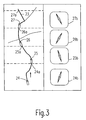
- FIG. 3 shows a route 23 with four different instantaneous routes Vehicle positions 24, 25, 26 and 27 and four of these vehicle positions assigned distance points 24a, 25a, 26a and 27a. To every one of these four current vehicle positions 24, 25, 26 and 27 is the associated first one Direction display 24b, 25b, 26b and 27b shown.
- FIG. 4 shows the course of a route 30 which has a sharp left curve 30a having.
- the vehicle is at the current vehicle position 31 the left turn 30a.
- a curve Secondary road 32 essentially straight ahead.
- This side street 32 is not digitized, i.e. 1 in the card storage unit 3 according to FIG Mauies 32 no information available, and accordingly can by the Card storage unit 3 according to FIG. 1 also has no information about it Secondary road 32 can be transmitted to the computing circuit 1 according to FIG. 1.
- the current vehicle position 31 is assigned a screen display 33 which is provided for display on the optical output module 7 according to FIG. 1.
- the screen display 33 has a first directional display 34 and, as a second directional display, a straight-ahead arrow 35.
- the straight-ahead arrow 35 signals to the driver that there are currently no indications of changes in direction of travel and that he should remain on the current road. Since the navigation system does not know the secondary road 32, there is no explicit acoustic signal in front of the left curve 32 that the driver should drive to the left. However, the driver can use the first direction indicator 34 to clarify that he should follow the left curve 30a and should not continue straight ahead along the non-digitized secondary road 32.
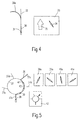
- FIG. 5 shows a planned route 36, which is at a circular intersection 37 with five branches 37a, 37b, 37c, 37d and 37e. 5 are four current vehicle positions 38, 39, 40 and 41 are shown. These four current vehicle positions 38, 39, 40 and 41 are the first Direction indicators 38a, 39a 40a and 41a assigned. In addition to the first Direction indicators 38a, 39a, 40a and 41a is a second direction indicator 42 provided, which is an abstract intersection of the circular Crossing 37 indicates. The planned route is on this second one Direction indicator 42 optically highlighted.
- the second direction indicator 42 changes not while driving through the circular intersection 37 and will statically displayed for all four current vehicle positions 38, 39, 40 and 41, while the first direction indicators 38a, 39a, 40a and 41a each follow according to the current vehicle position. If a user now approaches the circular intersection 37, he can himself first of all, an overview of what is going on using the second direction indicator 42 get him circular intersection 37 and the planned View route 36. If he then enters the circular intersection 37, he can preferably by means of the respectively current first direction indicator 38a, 39a, Orient 40a or 41a and find the right turn 37c.
- FIG. 6 shows a planned route 44, which is initially in an area I runs straight, in an adjoining area II some curves and finally runs in a straight line again in an area III. Based This planned route 44 is a change in the course of the roadway Distance traveled explained.
- This current vehicle position 45 is a distance point 45a assigned to the distance 45b along the planned route 44 is from the current vehicle position 45.
- the current one Vehicle position 45 is a first direction indicator 45c with a vertical orientation Direction directional arrow 45d assigned.
- the distance 45b is a predefinable for the respective type of route 44 Distance normal value, e.g. in a memory of the computing unit 1 is saved. This distance distance normal value is then always for the Distance traveled distance used when the particular course of the road essentially is straightforward and the speed of the vehicle in a predetermined Speed range.
- the vehicle arrives at the current vehicle position 46, which is the distance traveled by the distance 46b Distance point 46a is assigned.
- the distance 46b is essentially the same as the distance 45b.
- the distance point 46a is at the beginning a left turn.
- the direction arrow 46d is that of the current one Vehicle direction 46 associated with first direction indicator 46c slightly to the left directed towards the vertical direction.
- the arithmetic circuit 1 recognizes this Angular deviation from the vertical direction and subsequently reduced automatically the distance traveled when the amount of angular deviation a predefinable limit value during a predefinable minimum travel distance exceeds. This can be seen from the current vehicle position 47, whose assigned distance point 47a by the distance 47b.
- the Distaliz route 47b is automatically reduced by the computing circuit 1 and only about half the distance 45b and 46b.
- the first directional display 47c associated with the current vehicle position 47 has a directional arrow 47d, which is about 45 ° with respect to the vertical is inclined.
- the driver can the curved course of the route 44 in the area II by means of the first Direction display can be displayed in a suitable manner. From the arithmetic circuit 1 is checked continuously or at discrete intervals whether the amounts of the Angular deviations from the vertical direction during the predeterminable The minimum travel distance is still above the specifiable limit. in the curved region II of route 44, this is the case, and accordingly the small value for the distance traveled is still used.
- This distance 48b corresponds essentially to that Distance distance 47b and is approximately half the distance distance distance 45b and 46b.
- the direction arrow 48d of the current vehicle position 48 assigned first direction indicator 48 is about 45 ° to the right compared to inclined in the vertical direction.
- the vehicle leaves the curved area II and arrives in the rectilinear area III, the computing circuit 1 recognizes 1 that the first directional display is again in the vertical direction sets and falls below the predefinable limit value for the angular deviation.
- the predefinable limit value for the angular deviation remains during the the specified minimum travel distance is undershot, then the distance traveled is again increased to the predeterminable normal value for the respective lane type. That's the way it is assigned the current vehicle position 49 to the distance point 49a, which by the Distance 49b from the current vehicle position 49 is removed.
- the Distance 49b corresponds to distance 45b and 46b.
- Direction indicator 49c points in the vertical direction.
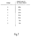
- Fig. 7 shows a table with seven different road types A to G, the a normal value for the distance traveled in meters is assigned.
- the Road types A to G are based on the expected average speed Classified and in each case in the card storage unit 3 according to FIG. 1 assigned stored streets.
- the lane type A represents motorways that Road type B federal roads, road type C well-developed country roads, the Road type D medium well-developed country roads, road type E poor upgraded country roads and F and G types of inner-city roads.
- the normal values for the respective road types A to G for the Distance routes are used advantageously if the current one Road is straight and the speed of the vehicle is within a predeterminable normal speed range.
- Driving the vehicle The computing circuit 1 according to FIG. 1 recognizes this faster on the basis of the Calculation circuit 1 supplied speed information, and the value for the distance traveled is continuous or gradual except for one Maximum value increased. If the vehicle has a speed below the Normal speed range, the distance will be continuous or reduced in steps to a predeterminable minimum value.
- the change of the road course dependent Normal values are provided for the distance traveled, as already shown in FIG. 6 described.
Abstract
Description
Die Erfindung betrifft ein Verfahren zur Ausgabe von Richtungsinformationen bezüglich einer mittels eines Navigationsssystems geplanten Fahrtroute sowie ein Fahrzeug-Navigationssystem mit einer Rechenschaltung
- zur Berechnung einer Fahrtroute
- zur Positionsbestimmung des Fahrzeugs mittels wenigstens eines Sensorsignals
- to calculate a route
- for determining the position of the vehicle by means of at least one sensor signal
Ein derartiges Verfahren zur Ausgabe von Richtungsinformationen sowie ein derartiges Navigationssystem ist beispielsweise aus der EP 534 533 A1 bekannt. Bei diesem bekannten Verfahren werden die Richtungsinformationen in Form von abstrahierten Kreuzungsdarstellungen angezeigt. Die Anzeige der abstrahierten Kreuzungsdarstellungen ist insbesondere für volldigitalisierte Gebiete geeignet, d.h. für Gebiete, in denen jede einzelne Straße dieses Gebietes im Kartenspeicher des Navigationssystems gespeichert ist. Dies trifft vor allem für größere Städte zu. Kleinere Städte sowie ländliche Gebiete stehen im Kartenspeicher des Navigationssystems jedoch vielfach nur teildigitalisiert zur Verfügung, d.h. nicht jede Straße in diesem Gebiet ist im Speicher des Navigationssystems erfaßt. An Kreuzungen oder Straßenabzweigungen, die nicht vom Speicher des Navigationssystems erfaßt sind, kann es daher bei einem Fahrer eines mit einem derartigen Navigationssystem ausgestatteten Fahrzeugs zu Urklarheiten bzw. Mißverständnissen bezuglich der zu fahrenden Route kommen. Such a method for output of directional information as well as a Such a navigation system is known for example from EP 534 533 A1. At In this known method, the direction information is in the form of abstracted intersection displays. The display of the abstracted Intersection representations are particularly suitable for fully digitized areas, i.e. for areas in which every single street of this area in the map memory of the Navigation system is saved. This is especially true for larger cities. Smaller cities and rural areas are in the map memory of the However, the navigation system is often only partially digitized, i.e. Not every street in this area is recorded in the memory of the navigation system. On Crossroads or road junctions that are not from the store of the Navigation system are detected, it can therefore be one with a driver vehicle equipped with such a navigation system for basic clarifications or Misunderstandings arise regarding the route to be traveled.
Daher ist z.B. bei dem Navigationssystem CARIN der Fa. PHILIPS zusätzlich zu der abstrahierten Kreuzungsdarstellung eine Umgebungskarte anzeigbar, die insbesondere zur Orientierung in teildigitalisierten Gebieten vorgesehen ist. Um eine derartige Umgebungskarte zufriedenstellend darstellen zu können, ist ein hochauflösender Bildschirm erforderlich.Therefore e.g. in addition to the CARIN navigation system from PHILIPS a map of the surroundings can be shown in the abstracted intersection display is provided in particular for orientation in partially digitized areas. To one To be able to represent such a map of the area satisfactorily is a high resolution screen required.
Es ist Aufgabe der Erfindung, ein Verfahren sowie ein Navigationssystem der eingangs genannten Art zu schaffen, das einfach und kostengünstig realisierbar ist und auch in teildigitalisierten Gebieten eine einfache, zuverlässige und eindeutige Anzeige von Richtungsinformationen ermöglicht.It is an object of the invention, a method and a navigation system to create the type mentioned that is simple and inexpensive to implement and also simple, reliable and clear in partially digitized areas Direction information can be displayed.
Diese Aufgabe ist erfindungsgemäß für ein Verfahren dadurch gelöst, daß eine erste Richtungsanzeige zur Anzeige der direkten Richtung von einer momentanen Fahrzeugposition zu einem auf der Fahrtroute liegenden, um eine Distanzfahrstrecke entlang der geplanten Fahrtroute entfernten Distanzpunkt vorgesehen ist, wobei der Distanzpunkt kontinuierlich in Abhängigkeit der Fahrzeugposition angepaßt wird.This object is achieved for a method in that a first Direction indicator to show the direct direction from a current one Vehicle position to a lying on the route by a distance a distance point is provided along the planned route, the Distance point is continuously adjusted depending on the vehicle position.
Die erste Richtungsanzeige dient somit der Anzeige der geplanten Richtung in der nahen Umgebung der momentanen Fahrzeugposition. Hierzu wird die direkte Richtung, d.h. die Richtung entlang der Luftlinie von der jeweils aktuellen Fahrzeugposition zu einem auf der Fahrtroute liegenden Distanzpunkt angezeigt. Der Distanzpunkt liegt dabei in Fahrtrichtung vor der momentanen Fahrzeugposition und ist um eine jeweilige Distanzfahrstrecke, d.h. die Strecke entlang der geplanten Straße bzw. Route, von der jeweils momentanen Fahrzeugposition entfernt. Während der Fahrt wird der Distanzpunkt mit sich ändernder Fahrzeugposition verschoben und somit der Fahrzeugposition angepaßt.The first direction indicator is used to show the planned direction in the close surroundings of the current vehicle position. For this, the direct Direction, i.e. the direction along the straight line from the current one Vehicle position to a distance point on the route is displayed. Of the The distance point is in the direction of travel before the current vehicle position and is a respective distance traveled, i.e. the route along the planned Road or route, from the current vehicle position. During the journey, the distance point becomes the vehicle's position changes moved and thus adapted to the vehicle position.
Der Distanzpunkt liegt vorzugsweise in einer Größenordnung von ca. 50 m bis ca. 500 m entlang der geplanten Fahrtroute von der momentanen Fahrzeugposition entfernt. The distance point is preferably on the order of approximately 50 m to approx. 500 m along the planned route from the current vehicle position away.
Die erste Richtungsanzeige ermöglicht insbesondere in teildigitalisierten Gebieten eine ständige, kontinuierliche Anzeige der in der unmittelbaren Umgebung geplanten Fahrtrichtung. Bei zweifelhaften Kreuzungen kann der Benutzer mit einem Blick die geplante Richtung erkennen und die Fahrt in der richtigen Richtung fortsetzen. Die erste Richtungsanzeige ermöglicht dem Fahrer eine kontinuierliche Richtungsinformation, auch wenn keine aktiven Hinweise. z.B. daß er an einer Kreuzung abbiegen soll, vorliegen.The first directional display enables particularly in partially digitized areas a constant, continuous display of those planned in the immediate vicinity Direction of travel. In case of doubtful crossings, the user can see the Recognize the planned direction and continue the journey in the right direction. The The first direction indicator enables the driver to continuously Directional information, even if there is no active information. e.g. that he was at one Turn should be present.
Die erste Richtungsanzeige läßt sich sehr einfach z.B. in Form eines geradlinigen Pfeiles oder in Form einer Kompaßnadel darstellen. Daher läßt sich die erste Richtungsanzeige auch auf einfachen Displays bzw. Bildschirmen, z.B. auf Monochrom-Bildschirmen, realisieren.The first direction display can be very easily e.g. in the form of a straight line Represent arrow or in the form of a compass needle. Hence the first Direction indication also on simple displays or screens, e.g. on Realize monochrome screens.
Eine vorteilhafte Ausgestaltung des erfindungsgemäßen Verfahrens ist dadurch gekennzeichnet, daß die Distanzfahrstrecke variierbar ist.This is an advantageous embodiment of the method according to the invention characterized in that the distance traveled is variable.
Eine Variation der Distanzfahrstrecke ermöglicht es, die Distanzfahrstrecke an verschiedene Parameter, z.B. Fahrzeugparameter, Umgebungsparameter und Straßenparameter, anzupassen und dadurch die erste Richtungsanzeige für den Benutzer zu optimieren.A variation of the distance traveled enables the distance traveled to be displayed various parameters, e.g. Vehicle parameters, environmental parameters and Road parameters, adjust and thereby the first directional display for the Optimize users.
Eine weitere vorteilhafte Ausgestaltung des erfindungsgemäßen Verfahrens ist
gekennzeichnet durch die Merkmale des Anspruchs 3.Another advantageous embodiment of the method according to the invention is
characterized by the features of
Insbesondere ist es vorteilhaft, die Distanzfahrstrecke mit zunehmender Fahrzeuggeschwindigkeit zu erhöhen. Diese Erhöhung kann sowohl kontinuierlich als auch schrittweise erfolgen. Mittels einer geschwindigkeitsabhängigen Änderung der Distanzfahrstrecke ist es möglich, das Verfahren derart zu realisieren, daß das Fahrzeug den jeweiligen Distanzpunkt jeweils im wesentlichen in derselben Zeitspanne erreicht. In particular, it is advantageous to increase the distance traveled Increase vehicle speed. This increase can be both continuous as well as gradually. By means of a speed-dependent change the distance traveled, it is possible to implement the method in such a way that Vehicle the respective distance point essentially in the same Time span reached.
Dadurch ist es möglich, den Distanzpunkt an das sich mit der Fahrzeuggeschwindigkeit ändernde Blickfeld des Fahrers anzupassen. Je schneller ein Fahrzeug fährt, desto weiter wird der Fahrer seinen Blick nach vorne richten. Somit kann mittels der geschwindigkeitsabhängigen Änderung der Distanzfahrstrecke der Distanzpunkt an das der jeweiligen Fahrzeuggeschwindigkeit entsprechende Blickfeld des Fahrers angepaßt werden. Als Geschwindigkeitssensor kann z.B. der Tachometer des Fahrzeugs verwendet werden.This makes it possible to find the distance point to which the Adjust the driver's vehicle speed changing field of vision. The faster a vehicle drives, the further the driver will look ahead. Thus, by means of the speed-dependent change in the distance traveled the distance point to that corresponding to the respective vehicle speed Driver's field of vision can be adjusted. As a speed sensor e.g. of the Speedometer of the vehicle can be used.
Eine weitere vorteilhafte Ausgestaltung der Erfindung ist gekennzeichnet durch die
Merkmale des Anspruchs 4.A further advantageous embodiment of the invention is characterized by the
Features of
Unter dem Fahrbahnryp wird die jeweilige Klassifikation verstanden, unter der die einzelnen Straßen im Kartenspeicher des Navigationssystems Klassifiziert sind. Als Klassifikationstypen sind z.B. Autobahnen, Bundesstraßen, Landesstraßen, Nebenstraßen und ähnliches vorgesehen. Je höher die zu erwartende Durchschnittsgeschwindigkeit auf dem jeweiligen Fahrbahntyp ist, desto größer wird vorteilhaft die Distanzfahrstrecke für diesen Fahrbahntyp gewählt. So ist beispielsweise auf Autobahnen eine hohe Durchschnittsgeschwindigkeit zu erwarten. und der Fahrbahnverlauf einer Autobahn weist normalerweise nur wenige Kurven auf. Daher ist es vorteilhaft, für Autobahnen eine große Distanzfahrstrecke vorzusehen. Dagegen ist auf einer Kleinen Nebenstraße eine geringere Durchschnittsgeschwindigkeit sowie ein deutlich kurvenreicherer Verlauf der Fahrbahn zu erwarten. Deshalb ist es vorteilhaft, für den Fahrbahntyp Nebenstraße eine geringere Distanzfahrstrecke vorzusehen. Insbesondere ist es vorteilhaft, für die einzelnen, in dem Kartenspeicher abgelegten Fahrbahntypen des Navigationssystems einen Richtwert für die Distanzfahrstrecke vorzusehen und diesen in Abhängigkeit der Fahrzeuggeschwindigkeit zu verändern.The type of roadway is understood to mean the respective classification under which the individual streets in the map memory of the navigation system are classified. As Classification types are e.g. Motorways, federal highways, state roads, Side streets and the like are provided. The higher the expected Average speed on the respective lane type is the greater advantageously selected the distance traveled for this type of road. So is For example, a high average speed can be expected on motorways. and the course of a freeway usually shows few curves on. It is therefore advantageous to have a long distance for highways to provide. In contrast, there is a smaller one on a small side street Average speed and a significantly more curvy course of the Lane expected. Therefore, it is advantageous for the road type of secondary road to provide a shorter distance. In particular, it is advantageous for individual lane types of the navigation system stored in the map memory to provide a guideline for the distance traveled and this depending to change the vehicle speed.
Der optimale Wert der Distanzfahrstrecke ist stark vom jeweiligen Fahrbahnverlauf abhängig. Mittels der fahrbahnabhängigen Änderung der Distanzfahrstrecke kann diese und damit die jeweilige Richtungsanzeige für den jeweiligen Fahrbahnverlauf optimiert werden. Insbesondere bei speziellen Kurvengeometrien ist es sinnvoll, die Distanzfahrstrecke verhältnismäßig klein zu wählen. Dies kann durch eine automatische Anpassung der Distanzfahrstrecke in Abhängigkeit des Fahrbahnverlaufs realisiert werden.The optimal value of the distance traveled is strongly dependent on the course of the road dependent. By changing the distance depending on the road surface this and thus the respective direction indicator for the respective lane course be optimized. In the case of special curve geometries in particular, it makes sense to use the Distance distance to choose relatively small. This can be done through a automatic adaptation of the distance traveled depending on the Lane course can be realized.
Beispielsweise ist es möglich, in vorgebbaren Zeitabständen die jeweiligen Winkel der ersten Richtungsanzeige in einem Speicher abzulegen und mit einer Rechenschaltung auszuwerten. Übersteigt die Winkeldifferenz zwischen einzelnen aufeinanderfolgenden Winkeln einen vorgebbaren Grenzwert, so wird automatisch die Distanzfahrstrecke erniedrigt.For example, it is possible to specify the respective angles at predeterminable time intervals to store the first direction indicator in a memory and with a Evaluate arithmetic circuit. Exceeds the angular difference between individuals successive angles a predeterminable limit value, so is automatically the distance traveled is reduced.
Eine weitere Möglichkeit besteht darin, den Fahrbahnverlauf zwischen der momentanen Fahrzeugposition und dem momentanen Distanzpunkt auszuwerten. Hierzu ist vorgesehen, auf der Distanzfahrstrecke zwischen der momentanen Fahrzeugposition und dem momentanen Distanzpunkt jeweils in äquidistanten Abständen Unterdistanzpunkte festzusetzen und zu diesen Unterdistanzpunkten den jeweiligen Winkel der ersten Richtungsanzeige bezüglich der momentanen Fahrzeugposition zu berechnen. Übersteigt die Winkeldifferenz zwischen diesen einzelnen berechneten Winkeln einen vorgebbaren Grenzwert, so wird automatisch die Distanzfahrstrecke verkleinert.Another option is to change the course of the road between the evaluate the current vehicle position and the current distance point. For this purpose it is provided on the distance between the current one Vehicle position and the current distance point in each case in equidistant Distances to set sub-distance points and to these sub-distance points respective angle of the first directional display with respect to the current one Calculate vehicle position. Exceeds the angular difference between them a predefined limit value for each calculated angle, it will automatically the distance traveled is reduced.
Eine andere Möglichkeit besteht darin, für vorgebbare Kreuzungsgeometrien vorgebbare Distanzfahrstrecken vorzusehen. Bei Erkennung dieser vorgebbaren Kreuzungsgeometerien werden dann bei der Durchfahrt durch die jeweilige Kreuzung die vorgebbaren Distanzfahrstrecken für die erste Richtungsanzeige verwendet. Die Erkennung der vorgebbaren Kreuzungsgeometrien kann beispielsweise mittels eines Mustererkennungs-Algorithmusses erfolgen. Weiterhin ist es vorteilhaft, die Distanzfahrstrecke in Abhängigkeit der Fahrbahnbeschaffenheit zu verändern. Another possibility is for predefinable intersection geometries to provide predeterminable distance routes. When this predeterminable is recognized Intersection geometers are then passed through the respective Intersection of the predefinable distance routes for the first direction display used. The predeterminable intersection geometries can be recognized for example by means of a pattern recognition algorithm. It is also advantageous to vary the distance traveled depending on the To change the road surface.
Unter Fahrbabnbeschaffenheit wird hierbei z.B. die Rauhigkeit der Fahrbahnoberfläche verstanden. Ist die Fahrbahn sehr uneben und holprig, so wird der Fahrer üblicherweise langsamer fahren und dementsprechend sich sein Blickfeld verkleinern. Daher ist es günstig, bei unebenen Fahrbahnen die Distanzfahrstrecke zu erniedrigen. Gleiches gilt, wenn die Fahrbahn naß, rutschig oder vereist ist.Under lane conditions, e.g. the roughness of the Understand the road surface. If the road is very uneven and bumpy, it will the driver usually drives slower and accordingly his field of vision downsize. It is therefore a good idea to cover the distance on uneven roads to humiliate. The same applies if the road is wet, slippery or icy.
Eine weitere vorteilhafte Ausgestaltung des erfindungsgemäßen Verfahrens ist dadurch gekennzeichnet, daß die Distanzfahrstrecke in Abhängigkeit der Licht- und/oder Sichtverhältnisse änderbar ist.Another advantageous embodiment of the method according to the invention is characterized in that the distance traveled depending on the light and / or Visibility is changeable.
Fährt der Fahrer nachts, so ist sein Blickfeld auf den Ausleuchtbereich des Abblend- bzw. Fernlichtes beschränkt, und die Distanzfahrstrecke kann an diesen Abblend- bzw. Fernlichtbereich angepaßt werden, so daß der Distanzpunkt innerhalb der Sichtweite des Fahrers liegt. Außerdem ist es möglich, die Distanzfahrstrecke an andere Einschränkungen der Sichtverhältnisse, z.B. bei Nebel, anzupassen.If the driver drives at night, his field of vision is the illuminated area of the dipped or High beam, and the distance can be dipped or High beam range can be adjusted so that the distance point within the Visibility of the driver is. It is also possible to show the distance traveled other restrictions on visibility, e.g. in fog.
Als Helligkeitssensoren sind z.B. Fotodioden verwendbar. Ferner ist es möglich, den Schalter für das Abblend- bzw. Fernlicht des Fahrzeugs als Helligkeitssensor zu verwenden, und in Abhängigkeit davon, ob das Fernlicht, das Abblendlicht oder gar kein Licht eingeschaltet ist, eine vorgebbare Distanzfahrstrecke einzustellen.The brightness sensors are e.g. Photo diodes can be used. It is also possible the switch for the low or high beam of the vehicle as a brightness sensor use, and depending on whether the high beam, the low beam or even no light is switched on, to set a predefinable distance.
Es ist weiter möglich, für die Distanzfahrstrecke einen festen Wert zu wählen.It is also possible to choose a fixed value for the distance traveled.
Ein derartiger fester Wert ermöglicht eine besonders einfache Realisierung des Verfahrens. Es ist jedoch denkbar, daß der feste Wert z.B. vor der Fahrt oder bei Inbetriebnahme eines Fahrzeugs von einem Benutzer vorgegeben werden kann.Such a fixed value enables a particularly simple implementation of the Procedure. However, it is conceivable that the fixed value e.g. before the trip or at Commissioning of a vehicle can be specified by a user.
Eine weitere vorteilhafte Ausgestaltung des erfindungsgemäßen Verfahrens ist
gekennzeichnet durch die Merkmale des Anspruchs 6. Another advantageous embodiment of the method according to the invention is
characterized by the features of
Eine derartige Kombination der ersten und der zweiten Richtungsanzeige ermöglicht in Abhängigkeit von den zur Verfügung stehenden Karteninformationen eine jeweils optimale Richtungsanzeige. Die Software des jeweiligen Navigationssystems erkennt automatisch, ob die Karteninformationen für die jeweilige Fahrzeugposition in teildigitalisierter oder volldigitalisierter Form vorliegen. Liegen die Daten in teildigitalisierter Form vor, so wird vorzugsweise die erste Richtungsanzeige angezeigt, während bei volldigitalisierten Umgebungen die zweite Richtungsanzeige vorgesehen ist. Teilweise kann es auch bei volldigitalisierten Umgebungen vorteilhaft sein, zusätzlich zu der abstrahierten Kreuzungsdarstellung die erste Richtungsanzeige vorzusehen.Such a combination of the first and the second direction indicator enables depending on the card information available optimal direction indicator. The software of the respective navigation system recognizes automatically whether the map information for the respective vehicle position in partially digitized or fully digitized form. Are the dates in partially digitized form, so the first directional display is preferably displayed, while in fully digitized environments the second direction indicator is provided. Sometimes it can also work in fully digitized environments to be advantageous, in addition to the abstract crossing representation, the first Direction display to be provided.
Falls gemäß den aktuellen Navigationsinformationen der aktuellen Straße gefolgt werden soll, kann zusätzlich zu der ersten Richtungsanzeige ein Geradeaus-Pfeil angezeigt werden.If followed according to the current navigation information of the current street a straight-ahead arrow can be used in addition to the first direction indicator are displayed.
Ein derartiger Geradeaus-Pfeil signalisiert dem Benutzer, daß das Navigationssystem derzeit keine Fahrtrichtungsänderungshinweise für ihn vorliegen hat und daß er dem gegenwärtigen Straßenverlauf folgen soll. Bei unklaren Situationen, z.B. wenn in einer scharfen Kurve eine nicht digitalisierte Abzweigung auftritt, kann der Benutzer anhand der ersten Richtungsanzeige erkennen, wie er fahren soll.Such a straight-ahead arrow signals to the user that the navigation system currently has no direction changes for him and that he should follow the current course of the road. In unclear situations, e.g. if in a non-digitized turn occurs on a sharp curve, the user can recognize how he should drive from the first direction indicator.
Eine weitere vorteilhafte Ausgestaltung des erfindungsgemäßen Verfahrens ist gekennzeichnet durch die Merkmale des Anspruchs 7.Another advantageous embodiment of the method according to the invention is characterized by the features of claim 7.
Bei kreisförmigen Kreuzungen mit vielen Abzweigungen ist für den Fahrer die Orientierung innerhalb der Kreuzung mittels der zweiten Richtungsanzeige vielfach schwierig. Mit der ersten Richtungsanzeige erhält der Fahrer innerhalb der kreisförmigen Kreuzung eine zusätzliche Hilfe, um die richtige Abzweigung zu finden. In the case of circular intersections with many branches, that is for the driver Orientation within the intersection by means of the second direction indicator difficult. With the first direction indicator, the driver receives within the circular intersection is an additional aid to making the right turn Find.
Die Aufgabe der Erfindung ist bei einem Fahrzeug-Navigationssystem dadurch gelöst, daß
- die Rechenschaltung zur Lieferung von ersten Richtungsinformationen für eine erste Richtungsanzeige an die Ausgabevorrichtung vorgesehen ist,
- die Ausgabevorrichtung zur Anzeige der ersten Richtungsanzeige vorgesehen ist, wobei die erste Richtungsanzeige die direkte Richtung von der jeweils momentanen Fahrzeugposition zu einem jeweils um eine Distanzfahrstrecke von der jeweiligen Fahrzeugposition entfernten, auf der Fahrtroute liegenden Distanzpunkt anzeigt.
- the arithmetic circuit is provided for supplying first directional information for a first directional display to the output device,
- the output device is provided for displaying the first directional display, the first directional display showing the direct direction from the current vehicle position to a distance point on the travel route that is a distance in each case from the respective vehicle position.
Die Rechenschaltung berechnet mittels des Sensorsignals die jeweils momentane Position des Fahrzeugs. In Abhängigkeit dieser momentanen Position des Fahrzeugs wird ein Distanzpunkt von der Rechenschaltung bestimmt, der um eine Distanzfahrstrecke entlang der geplanten Fahrtroute in Fahrtrichtung von der momentanen Fahrzeugposition entfernt ist. Nun berechnet die Rechenschaltung als erste Richtungsinformation die direkte Richtung, d.h. die Richtung entlang der Luftlinie von der momentanen Fahrzeugposition zu dem Distanzpunkt. Diese erste Richtungsinformation wird von der Rechenschaltung an die Ausgabevortichtung geliefert, welche die erste Richtungsanzeige optisch anzeigt.The computing circuit uses the sensor signal to calculate the current one Position of the vehicle. Depending on the current position of the vehicle a distance point is determined by the arithmetic circuit, which is one Distance traveled along the planned route in the direction of travel from current vehicle position is removed. Now the arithmetic circuit calculates as first direction information the direct direction, i.e. the direction along the Air line from the current vehicle position to the distance point. This first Direction information is sent from the arithmetic circuit to the output device supplied, which visually shows the first direction indicator.
Bei einer vorteilhaften Ausgestaltung des Navigationssystems ist die Rechenschaltung zur Variation der Distanzfahrstrecke vorgesehen. Eine Variation der Distanzfahrstrecke ermöglicht es, die Distanzfahrstrecke an verschiedene Parameter, z.B. Fahrzeugpararneter, Umgebungsparameter und Straßenparameter, anzupassen und dadurch die erste Richtungsanzeige für den Benutzer zu optimieren.In an advantageous embodiment of the navigation system the arithmetic circuit is provided to vary the distance traveled. A variation of the distance traveled enables the distance traveled to be displayed various parameters, e.g. Vehicle parameters, environmental parameters and Road parameters, adjust and thereby the first directional display for the Optimize users.
Der optimale Wert der Distanzfahrstrecke ist stark vom jeweiligen Fahrbahnverlauf abhängig und kann durch eine softwaremäßig in der Rechenschaltung durchgeführte automatische Anpassung der Distanzfahrstrecke eingestellt werden. Beispielsweise ist es möglich, in vorgebbaren Zeitabständen die jeweiligen Winkel der ersten Richtungsanzeige in einem Speicher abzulegen und mittels der Rechenschaltung auszuwerten. Übersteigt die Winkeldifferenz zwischen einzelnen aufeinanderfolgenden Winkeln einen vorgebbaren Grenzwert, so wird von der Rechenschaltung automatisch die Distanzfahrstrecke erniedrigt. Des weiteren ist es vorteilhaft, daß in die Rechenschaltung ein Mustererkennungs-Algorithmus implementiert ist, der automatisch bei Erkennung von vorgebbaren Kreuzungsgeometerien vorgebbare, z.B. in einem Speicher des Navigationssystems abgelegte Distanzfahrstrecken verwendet. Eine andere Möglichkeit besteht darin, daß die in einer Kartenspeichereinheit des Navigationssystems gespeicherten Karteninformationen für vorgebbare Kreuzungen bzw. Straßenverläufe als Zusatz-Informationen jeweils die für diese Kreuzung bzw. diesen Sträßenverlauf optimalen Distanzfahrstrecken aufweisen.The optimal value of the distance traveled is strongly dependent on the course of the road dependent and can be carried out by a software in the arithmetic circuit automatic adjustment of the distance traveled can be set. For example it is possible to specify the respective angles of the first at predetermined time intervals Direction display to store in a memory and by means of the arithmetic circuit evaluate. Exceeds the angular difference between individuals successive angles a predeterminable limit value, so the Arithmetic circuit automatically lowers the distance traveled. Furthermore, it is advantageous that a pattern recognition algorithm in the arithmetic circuit is implemented, which is automatically recognized when predeterminable Intersection geometries, e.g. in a memory of the navigation system distance journeys used. Another option is that the stored in a map storage unit of the navigation system Map information for predeterminable intersections or road courses as Additional information in each case for this intersection or this course of the road have optimal distance routes.
Ferner ist es vorteilhaft, daß der Rechenschaltung mittels einer Eingabevorrtichtung von einem Benutzer ein Vorgabewert für die Distanzfahrstrecke vorgebbar ist. Mittels eines solchen, von dem Benutzer eingebbaren Vorgabewertes kann jeder Fahrer die erste Richtungsanzeige an seine individuellen Bedürfnisse anpassen.It is also advantageous that the arithmetic circuit by means of an input device A default value for the distance traveled can be specified by a user. With such a default value that can be entered by the user, anyone Adjust the first direction indicator to the driver's individual needs.
Eine weitere vorteilhafte Ausgestaltung des Navigationssystems ist gekennzeichnet
durch die Merkmales des Anspruchs 9.Another advantageous embodiment of the navigation system is characterized
by the feature of
Eine derartige Kombination der ersten und der zweiten Richtungsanzeige ermöglicht
es, in Abhängigkeit der in der Kartenspeichereinheit des Navigationssystems zur
Verfügung stehenden Karteninformationen dem Benutzer eine jeweils optimale
Richtungsanzeige zu bieten. Die Software der Rechenschaltung erkennt automatisch,
ob die ihr von der Kartenspeichereinheit gelieferten Karteninfomationen für die
jeweilige Fahrzeugposition in teildigitalisierter oder volldigitalisierter Form
vorliegen. Liegen die Daten in teildigitalisierter Form vor, so werden von der
Rechenschaltung vorzugsweise die ersten Richtungsinformationen an die
Ausgabevorrichtung geliefert, und die erste Richtungsanzeige wird von der
Ausgabevorrichtung angezeigt, während bei volldigitalisierten Umgebungen die
zweite Richtungsanzeige vorgesehen ist. Teilweise kann es auch bei
volldigitalisierten Umgebungen vorteilhaft sein, zusätzlich zu der abstrahierten
Kreuzungsdarstellung die erste Richtungsanzeige mittels der Ausgabevorrichtung
anzuzeigen.
Die erste Richtungsanzeige läßt sich sehr einfach z.B. in Form eines geradlinigen
Pfeils oder in Form einer Kompaßnadel darstellen. Daher läßt sich die erste
Richtungsanzeige auch auf Bildschirmen mit einer geringen Auflösung, z.B. auf
Monochrom-Bildschirmen mit einer Auflösung von 64x120 Pixeln darstellen. Damit
lassen sich sehr kostengünstige Navigationssystem realisieren. Insbesondere ist es
möglich, für die erste Richtungsanzeige ein separates Display am Lenkrad des
Fahrzeuges anzuordnen. Ein derartiges Display kann quasi im Blickfeld des Fahrers
angeordnet werden. Der Fahrer kann mittels eines derartigen Displays sehr schnell
die ersten Richtungsinformationen aufnehmen, ohne seinen Blick von der Fahrbahn
abwenden zu müssen.Such a combination of the first and the second directional display makes it possible, depending on the map information available in the map storage unit of the navigation system, to offer the user an optimal directional display. The software of the arithmetic circuit automatically recognizes whether the card information supplied by the card storage unit for the respective vehicle position is available in partially digitized or fully digitized form. If the data is in partially digitized form, the computing circuit preferably delivers the first direction information to the output device, and the first direction indicator is displayed by the output device, while the second direction indicator is provided in fully digitized environments. In some cases, it can also be advantageous in fully digitized environments to display the first directional display in addition to the abstracted intersection by means of the output device.
The first directional display can be displayed very easily, for example in the form of a straight arrow or in the form of a compass needle. Therefore, the first directional display can also be shown on screens with a low resolution, for example on monochrome screens with a resolution of 64x120 pixels. This enables very inexpensive navigation systems to be implemented. In particular, it is possible to arrange a separate display on the steering wheel of the vehicle for the first direction indicator. Such a display can be arranged in the driver's field of vision. Using such a display, the driver can quickly record the first directional information without having to take his eyes off the road.
Einige schematisch dargestellte Ausführungsbeispiele der Erfindung werden
nachfolgend anhand der Zeichnung in den Fig. 1 bis 7 näher erläutert. Es zeigen:
Fig. 1 zeigt ein Blockschaltbild eines Ausführungsbeispiels eines erfindungsgemäßen
Navigationssystems, in welchem das erfindungsgemäße Verfahren realisiert ist. Das
in Fig. 1 dargestellte Navigationssystem weist als zentrales Element eine
Rechenschaltung 1 auf, welche mit einer Bedienvorrichtung 2, einer
Kartenspeichereinheit 3, einem RDS/TMC-Empfänger 4 sowie einem GSM-Modul 5
gekoppelt ist. Die Bedienvorrichtung 2 kann beispielsweise mittels einer Tastatur,
eines Trackballs oder eines berührungssensitiven Bildschirms (Touch Sreen)
realisiert werden. Die Kartenspeichereinheit 3 kann beispielsweise mittels eines
CD-ROM-Laufwerkes realisiert werden, wobei die Karteninformationen auf einer
oder mehreren CD-ROM's abgespeichert sind. Der RDS/TMC-Empfänger 4 dient
dem Empfang von Verkehrsinformationen. Mittels des GSM-Moduls können sowohl
Verkehrsinformationen, die nach dem GSM-Standard übertragen werden, empfangen
werden, als auch Telefongespräche durchgeführt werden.Fig. 1 shows a block diagram of an embodiment of an inventive
Navigation system in which the method according to the invention is implemented. The
The navigation system shown in FIG. 1 has a central element
Computing circuit 1, which with an
Es ist eine Ausgabevorrichtung 6 vorgesehen, die ein optisches Ausgabemodul 7 und
ein akustisches Ausgabemodul 8 umfäßt. Sowohl das optische Ausgabemodul 7 als
auch das akustische Ausgabemodul 8 sind mit der Rechenschaltung 1 gekoppelt. Es
ist eine Sensoreinheit 9 vorgesehen, die Radsensoren 10, einen elektronischen
Kompaß 11 sowie eine GPS-Empfangseinheit 12 aufweist. Die Radsensoren 10, der
Kompaß 11 und die GPS-Empfangseinheit 12 sind jeweils mit der Rechenschaltung 1
gekoppelt. Die Radsensoren 10 liefern Informationen von dem linken und dem
rechten Rad des Fahrzeuges, entweder von den Vorderrädern oder von den
Hinterrädern. Die Information der Radsensoren, die diese an die Rechenschaltung 1
übertragen, betrifft sowohl die vom Fahrzeug gefahrene Entfernung als auch
Richtungsänderungen infolge von unterschiedlich zurückgelegten Wegen des linken
und des rechten Rades. Der elektronische Kompaß 11 liefert Winkelinformationen
an die Rechenschaltung 1. Die GPS-Empfangseinheit 12 liefert
Positionsinformationen über die gegenwärtige Position des Fahrzeuges an die
Rechenschaltung 1. Aus den Informationen der Kartenspeichereinheit 3, der
Radsensoren 10, des Kompasses 11 und der GPS-Empfangseinheit 12 berechnet die
Rechenschaltung 1 die aktuelle Position des Fahrzeuges. Die Rechenschaltung 1
liefert in Abhängigkeit der aktuellen Fahrzeugposition Richtungsinformationen an die
Ausgabevorrichtung 6, welche die Richtungsinformationen optisch und/oder
akustisch dem Fahrer übermittelt. Es ist möglich, auf die GPS-Empfangseinheit 12
zu verzichten und das Navigationssystem nur mit der Kartenspeichereinheit 3, den
Radsensoren 10 und dem Kompaß 11 zu betreiben.An
Fig. 2 zeigt eine geplante Fahrtroute 13 mit einem sich an einer momentanen
Fahrzeugposition 14 befindlichen Fahrzeug 15. Um eine Distanzfahrstrecke 16
entlang der Fahrtroute 13 von der momentanen Fahrzeugposition 14 entfernt
befindet sich ein Distanzpunkt 17. In Richtung der Fahrzeuglängsachse des
Fahrzeuges 15 erstreckt sich ein Fahrzeuglängsrichtungspfeil 18. Von der
momentanen Fahrzeugposition 14 zu dem Distanzpunkt 17 erstreckt sich ein
Distanzpunkt-Richtungspfeil 19. Der Fahrzeuglängsrichtungspfeil 18 und der
Distanzpunkt-Richtungspfeil 19 erstrecken sich zueinander in einem
Distanzpunkt-Richtungswinkel ϕD. Dieser momentanen Fahrzeugposition 14 und dem
zugehörigen Distanzpunkt 17 ist eine erste Kichtungsanzeige 20 in Form einer
Kompaßnadel 21 zugeordnet. Diese erste Richtungsanzeige 20 wird auf dem
optischen Ausgabemodul 7 der Ausgabevorrichtung 6 gemäß Fig. 1 angezeigt. Die
Kompaßnadel 21 der ersten Richtungsanzeige 20 ist um den
Distanzpunkt-Richtungswinkel ϕD gegenüber der vertikalen Richtung 22 geneigt.FIG. 2 shows a
Der Distanzpunkt-Richtungswinkel ϕD wird von der Rechenschaltung 1 berechnet
und als erste Richtungsinformation an die Ausgabevorrichtung 6 geliefert.The distance point direction angle ϕ D is calculated by the arithmetic circuit 1 and supplied to the
Fig. 3 zeigt eine Fahrtroute 23 mit vier verschiedenen momentanen
Fahrzeugpositionen 24, 25, 26 bzw. 27 und vier diesen Fahrzeugpositionen
zugeordneten Distanzpunkten 24a, 25a, 26a bzw. 27a. Zu jeder einzelnen dieser vier
momentanen Fahrzeugpositionen 24, 25, 26 sowie 27 ist die jeweils zugehörige erste
Richtungsanzeige 24b, 25b, 26b bzw. 27b dargestellt.3 shows a
Fig. 4 zeigt den Verlauf einer Fahrtroute 30, die eine scharfe Linkskurve 30a
aufweist. Das Fahrzeug befindet sich an der momentanen Fahrzeugposition 31 vor
der Linkskurve 30a. Am Anfang der scharfen Linkskurve 30a verläuft eine
Nebenstraße 32 im wesentlichen geradeaus weiter. Diese Nebenstraße 32 ist nicht
digitalisiert, d.h. in der Kartenspeichereinheit 3 gemäß Fig. 1 sind über diese
Nebenstraße 32 keine Informationen vorhanden, und demgemäß können von der
Kartenspeichereinheit 3 gemäß Fig. 1 auch keine Informationen über diese
Nebenstraße 32 an die Rechenschaltung 1 gemäß Fig. 1 übermittelt werden. FIG. 4 shows the course of a
Der momentanen Fahrzeugposition 31 ist eine Bildschirmanzeige 33 zugeordnet, die
zur Anzeige auf dem optischen Ausgabemodul 7 gemäß Fig. 1 vorgesehen ist. Die
Bildschirmanzeige 33 weist eine erste Richtungsanzeige 34 und als zweite
Richtungsanzeige einen Geradeaus-Pfeil 35 auf. Der Geradeaus-Pfeil 35 signalisiert
dem Fahrer, daß derzeit keine Fahrtrichtungsänderungshinweise vorliegen und er auf
der gegenwärtigen Straße bleiben soll. Da das Navigationssystem die Nebenstraße
32 nicht kennt, erfolgt vor der Linkskurve 32 auch kein expliziter akustischer
Hinweis, daß der Fahrer nach links fahren soll.
Mittels der ersten Richtungsanzeige 34 kann sich der Fahrer jedoch Klarheit darüber
verschaffen, daß er der Linkskurve 30a folgen soll und nicht geradeaus weiter
entlang der nicht digitalisierten Nebenstraße 32 weiterfahren soll.The
However, the driver can use the
Fig. 5 zeigt eine geplante Fahrtroute 36, welche an einer kreisförmigen Kreuzung 37
mit fünf Abzweigungen 37a, 37b, 37c, 37d und 37e vorbeiführt. In der Fig. 5 sind
vier momentane Fahrzeugpositionen 38, 39, 40 und 41 dargestellt. Diesen vier
momentanen Fahrzeugpositionen 38, 39, 40 und 41 sind jeweils die ersten
Richtungsanzeigen 38a, 39a 40a sowie 41a zugeordnet. Zusätzlich zu den ersten
Richtungsanzeigen 38a, 39a, 40a sowie 41a ist eine zweite Richtungsanzeige 42
vorgesehen, welche eine abstrahierte Kreuzungsdarstellung der kreisförmigen
Kreuzung 37 anzeigt. Die geplante Fahrtroute ist auf dieser zweiten
Richtungsanzeige 42 optisch hervorgehoben. Die zweite Richtungsanzeige 42 ändert
sich während der Fahrt durch die kreisförmige Kreuzung 37 nicht und wird jeweils
bei allen vier momentanen Fahrzeugpositionen 38, 39, 40 und 41 statisch angezeigt,
während die ersten Richtungsanzeigen 38a, 39a, 40a und 41a jeweils nachfolgend
entsprechend der jeweiligen momentanen Fahrzeugposition angezeigt werden.
Fährt ein Benutzer nun auf die kreisförmige Kreuzung 37 zu, so kann er sich
zunächst mittels der zweiten Richtungsanzeige 42 einen Überblick über die sich vor
ihm befindliche kreisförmige Kreuzung 37 verschaffen und sich die geplante
Fahrtroute 36 ansehen. Fährt er dann in die kreisförmige Kreuzung 37 ein, kann er
sich vorzugsweise mittels der jeweils aktuellen ersten Richtungsanzeige 38a, 39a,
40a bzw. 41a orientieren und so die richtige Abzweigung 37c auffinden.FIG. 5 shows a
Fig. 6 zeigt eine geplante Fahrtroute 44, welche zunächst in einem Bereich I
geradlinig verläuft, in einem sich daran anschließenden Bereich II einige Kurven
aufweist und schließlich in einem Bereich III wieder geradlinig verläuft. Anhand
dieser geplanten Fahrtroute 44 wird eine fahrbahnverlaufsabhängige Änderung der
Distanzfahrstrecke erläutert. Zunächst befindet sich ein nicht näher dargestelltes
Fahrzeug an der momentanen Fahrzeugposition 45 am Anfang des geradlinigen
Bereiches I. Dieser momentanen Fahrzeugposition 45 ist ein Distanzpunkt 45a
zugeordnet, der um die Distanzfahrstrecke 45b entlang der geplanten Fahrtroute 44
von der momentanen Fahrzeugposition 45 entfernt ist. Der momentanen
Fahrzeugposition 45 ist eine erste Richtungsanzeige 45c mit einem sich in vertikaler
Richtung erstreckenden Richtungspfeil 45d zugeordnet. Die Distanzfahrstrecke 45b
ist ein für den jeweiligen Fahrbahuryp der Fahrtroute 44 vorgebbarer
Distanzfahrstrecken-Normalwert, der z.B. in einem Speicher der Recheneinheit 1
abgespeichert ist. Dieser Distanzfahrstrecken-Normalwert wird immer dann für die
Distanzfahrstrecke verwendet, wenn der jeweilige Straßenverlauf im wesentlichen
geradlinig ist und sich die Geschwindigkeit des Fahrzeugs in einem vorgebbaren
Geschwindigkeitsbereich befindet.FIG. 6 shows a
Dem Routenverlauf der Fahrtroute 44 folgend gelangt das Fahrzeug an die
momentane Fahrzeugposition 46, der der um die Distanzfahrstrecke 46b entfernte
Distanzpunkt 46a zugeordnet ist. Die Distanzfahrstrecke 46b ist im wesentlichen
gleich groß wie die Distanzfahrstrecke 45b. Der Distanzpunkt 46a liegt am Anfang
einer Linkskurve. Dementsprechend ist der Richtungspfeil 46d der der momentanen
Fahrzeugposition 46 zugeordneten ersten Richtungsanzeige 46c etwas nach links
gegenüber der vertikalen Richtung gerichtet. Die Rechenschaltung 1 erkennt diese
Winkelabweichung gegenüber der vertikalen Richtung und verkleinert nachfolgend
automatisch die Distanzfahrstrecke, wenn der Betrag der Winkelabweichung
während einer vorgebbaren Mindestfahrstrecke einen vorgebbaren Grenzwert
überschreitet. Dies ist an der momentanen Fahrzeugposition 47 zu erkennen, deren
zugeordneter Distanzpunkt 47a um die Distanzfahrstrecke 47b entfernt ist. Die
Distarizfahrstrecke 47b ist von der Rechenschaltung 1 automatisch verkleinert
worden und nur noch etwa halb so groß wie die Distanzfahrstrecken 45b und 46b.
Die der momentanen Fahrzeugposition 47 zugeordnete erste Richtungsanzeige 47c
weist einen Richtungspfeil 47d auf, der um ca. 45° gegenüber der Vertikalen
geneigt ist. Mittels dieser Verkleinerung der Distanzfahrstrecke kann dem Fahrer
der kurvenförmige Verlauf der Fahrtroute 44 in dem Bereich II mittels der ersten
Richtungsanzeige in geeigneter Weise angezeigt werden. Von der Rechenschaltung 1
wird kontinuierlich oder in diskreten Abständen geprüft, ob die Beträge der
Winkelabweichungen gegenüber der vertikalen Richtung während der vorgebbaren
Mindestfahrstrecke noch oberhalb des vorgebbaren Grenzwertes liegen. Im
kurvenförmigen Bereich II der Fahrtroute 44 ist dies der Fall, und dementsprechend
wird weiterhin der kleine Wert für die Distanzfahrstrecke verwendet. So ist
beispielsweise der der momentanen Fahrzeugposition 48 zugeordnete Distanzpunkt
48a um die Distanzfahrstrecke 48b von der momentanen Fahrzeugposition 48
entfernt. Diese Distanzfahrstrecke 48b entspricht im wesentlichen der
Distanzfahrstrecke 47b und ist in etwa halb so groß wie die Distanzfahrstrecken 45b
und 46b. Der Richtungspfeil 48d der der momentanen Fahrzeugposition 48
zugeordneten ersten Richtungsanzeige 48 ist um ca. 45° nach rechts gegenüber der
vertikalen Richtung geneigt. Verläßt das Fahrzeug den kurvenförmigen Bereich II
und gelangt in den geradlinigen Bereich III, so erkennt die Rechenschaltung 1
gemäß Fig. 1, daß die erste Richtungsanzeige sich wieder auf die vertikale Richtung
einstellt und den vorgebbaren Grenzwert für die Winkelabweichung unterschreitet.
Bleibt der vorgebbare Grenzwert für die Winkelabweichung während der
vorgebbaren Mindestfahrstecke unterschritten, so wird die Distanzfahrstrecke wieder
auf den vorgebbaren Normalwert für den jeweiligen Fahrbahnryp erhöht. So ist der
momentanen Fahrzeugposition 49 der Distanzpunkt 49a zugeordnet, welcher um die
Distanzfahrstrecke 49b von der momentanen Fahrzeugposition 49 entfernt ist. Die
Distanzfahrstrecke 49b entspricht den Distanzfahrstrecken 45b und 46b. Der
Richtungspfeil 49d der der momentanen Fahrzeugposition 49 zugeordneten ersten
Richtungsanzeige 49c weist in die vertikale Richtung.Following the route of
Fig. 7 zeigt eine Tabelle mit sieben verschiedenen Fahrbahnrypen A bis G, denen
jeweils ein Normalwert für die Distanzfahrstrecke in Metern zugeordnet ist. Die
Fahrbahntypen A bis G sind nach zu erwartender Durchschnittsgeschwindigkeit
Klassifiziert und jeweils den in der Kartenspeichereinheit 3 gemäß Fig. 1
gespeicherten Straßen zugeordnet. Der Fahrbahntyp A repräsentiert Autobahnen, der
Fahrbahntyp B Bundesstraßen, der Fahrbahntyp C gut ausgebaute Landstraßen, der
Fahrbahntyp D mittelgut ausgebaute Landstraßen, der Fahrbahntyp E schlecht
ausgebaute Landstraßen und die Fahrbahntypen F und G innerstädtische Straßen.Fig. 7 shows a table with seven different road types A to G, the
a normal value for the distance traveled in meters is assigned. The
Road types A to G are based on the expected average speed
Classified and in each case in the
Die den jeweiligen Fahrbahnrypen A bis G zugeordneten Normalwerte für die Distanzfahrstrecken werden vorteilhaft verwendet, wenn der momentane Straßenverlauf geradlinig ist und sich die Geschwindigkeit des Fahrzeugs innerhalb eines vorgebbaren Geschwindigkeits-Normalbereiches befindet. Fährt das Fahrzeug schneller, so erkennt dies die Rechenschaltung 1 gemäß Fig. 1 anhand von der Rechenschaltung 1 zugeführten Geschwindigkeitsinformationen, und der Wert für die Distanzfahrstrecke wird kontinuierlich oder schrittweise bis auf einen Maximalwert erhöht. Weist das Fahrzeug eine Geschwindigkeit unterhalb des Geschwindigkeits-Normalbereiches auf, so wird die Distanzfahrstrecke kontinuierlich oder in Schritten bis auf einen vorgebbaren Minimalwert erniedrigt. Zusätzlich zu der geschwindigkeitsabhängigen Änderung des Normalwertes für die Distanzfahrstrecke ist vorteilhaft die fahrbahnverlaufsabhängige Änderung des Normalwertes für die Distanzfahrstrecke vorgesehen, wie bereits in der Fig. 6 beschrieben.The normal values for the respective road types A to G for the Distance routes are used advantageously if the current one Road is straight and the speed of the vehicle is within a predeterminable normal speed range. Driving the vehicle The computing circuit 1 according to FIG. 1 recognizes this faster on the basis of the Calculation circuit 1 supplied speed information, and the value for the distance traveled is continuous or gradual except for one Maximum value increased. If the vehicle has a speed below the Normal speed range, the distance will be continuous or reduced in steps to a predeterminable minimum value. In addition to the speed-dependent change in the normal value for the Distance driving distance is advantageous the change of the road course dependent Normal values are provided for the distance traveled, as already shown in FIG. 6 described.
Claims (10)
daß in Abhängigkeit der für die Umgebung der jeweiligen Fahrzeugposition zur Verfügung stehenden Navigationsinformationen die erste und/oder die zweite Richtungsanzeige zur Führung verwendet wird, wobei
die erste Richtungsanzeige insbesondere zur Führung in teildigitalisierten Umgebungen und die zweite Richtungsanzeige insbesondere zur Führung in volldigitalisierten Umgebungen vorgesehen ist.Method according to Claim 1, characterized in that a second directional display is provided for displaying abstract intersection representations,
that depending on the navigation information available for the environment of the respective vehicle position, the first and / or the second direction indicator is used for guidance, wherein
the first directional display is intended in particular for guidance in partially digitized environments and the second directional display is intended in particular for guidance in fully digitized environments.
Applications Claiming Priority (2)
| Application Number | Priority Date | Filing Date | Title |
|---|---|---|---|
| DE19711092A DE19711092A1 (en) | 1997-03-17 | 1997-03-17 | Navigation system and method for outputting direction information from the navigation system |
| DE19711092 | 1997-03-17 |
Publications (3)
| Publication Number | Publication Date |
|---|---|
| EP0866311A2 true EP0866311A2 (en) | 1998-09-23 |
| EP0866311A3 EP0866311A3 (en) | 2000-04-05 |
| EP0866311B1 EP0866311B1 (en) | 2005-08-10 |
Family
ID=7823680
Family Applications (1)
| Application Number | Title | Priority Date | Filing Date |
|---|---|---|---|
| EP98200726A Expired - Lifetime EP0866311B1 (en) | 1997-03-17 | 1998-03-09 | Method for displaying directional information of a navigation system |
Country Status (5)
| Country | Link |
|---|---|
| US (1) | US6127969A (en) |
| EP (1) | EP0866311B1 (en) |
| JP (1) | JPH10267679A (en) |
| KR (1) | KR19980080332A (en) |
| DE (2) | DE19711092A1 (en) |
Families Citing this family (14)
| Publication number | Priority date | Publication date | Assignee | Title |
|---|---|---|---|---|
| US20060284839A1 (en) * | 1999-12-15 | 2006-12-21 | Automotive Technologies International, Inc. | Vehicular Steering Wheel with Input Device |
| US6567069B1 (en) * | 1998-11-25 | 2003-05-20 | Alliedsignal Inc. | Integrated display and yoke mechanism |
| DE19855794A1 (en) * | 1998-12-03 | 2000-06-21 | Hanjo Nyhuis | Personal navigation method e.g. used in building complex uses detected actual position and compass disc angular direction pulses compared with stored route for providing guidance directions to user via display |
| DE10007348C2 (en) * | 2000-02-18 | 2003-07-10 | Harman Becker Automotive Sys | navigation system |
| US6898517B1 (en) * | 2001-07-24 | 2005-05-24 | Trimble Navigation Limited | Vehicle-based dynamic advertising |
| TW521935U (en) * | 2001-11-09 | 2003-02-21 | Sin Etke Technology Co Ltd | Communication device for use in a car |
| JP4599932B2 (en) * | 2004-08-06 | 2010-12-15 | アイシン・エィ・ダブリュ株式会社 | Navigation system |
| KR101047719B1 (en) * | 2005-02-16 | 2011-07-08 | 엘지전자 주식회사 | Method and device for driving route guidance of moving object in navigation system |
| US7539574B2 (en) * | 2005-03-22 | 2009-05-26 | Denso Corporation | Vehicular navigation system |
| JP5028851B2 (en) * | 2006-04-24 | 2012-09-19 | 株式会社デンソー | Road information detection apparatus and program |
| EP2040034B1 (en) * | 2006-07-03 | 2012-08-29 | Pioneer Corporation | Navigation device and method, navigation program, and storage medium |
| CN101738189A (en) * | 2008-11-06 | 2010-06-16 | 环达电脑(上海)有限公司 | Navigation system and method thereof |
| CN101750079A (en) * | 2009-12-01 | 2010-06-23 | 华为终端有限公司 | Navigation directing method, device and system |
| CN110186452A (en) * | 2019-06-21 | 2019-08-30 | 深圳市联华盈科通讯技术有限公司 | Air navigation aid, device, computer equipment and its storage medium |
Citations (3)
| Publication number | Priority date | Publication date | Assignee | Title |
|---|---|---|---|---|
| DE3315613A1 (en) * | 1982-05-01 | 1983-11-03 | Honda Giken Kogyo K.K., Tokyo | DISPLAY DEVICE FOR THE CURRENT LOCATION OF A VEHICLE |
| EP0534533A1 (en) * | 1991-09-25 | 1993-03-31 | Koninklijke Philips Electronics N.V. | Device and method for displaying cartographic information in vehicular navigation |
| DE19516964A1 (en) * | 1995-05-12 | 1996-11-14 | Sel Alcatel Ag | Automatic vehicle guidance system |
Family Cites Families (4)
| Publication number | Priority date | Publication date | Assignee | Title |
|---|---|---|---|---|
| US5058023A (en) * | 1990-07-30 | 1991-10-15 | Motorola, Inc. | Vehicle position determining apparatus |
| US5488559A (en) * | 1993-08-02 | 1996-01-30 | Motorola, Inc. | Map-matching with competing sensory positions |
| US5724243A (en) * | 1995-02-10 | 1998-03-03 | Highwaymaster Communications, Inc. | Method and apparatus for determining expected time of arrival |
| JP2902340B2 (en) * | 1995-12-28 | 1999-06-07 | アルパイン株式会社 | Vehicle position correction method |
-
1997
- 1997-03-17 DE DE19711092A patent/DE19711092A1/en not_active Withdrawn
-
1998
- 1998-03-05 US US09/035,432 patent/US6127969A/en not_active Expired - Fee Related
- 1998-03-09 EP EP98200726A patent/EP0866311B1/en not_active Expired - Lifetime
- 1998-03-09 DE DE59812982T patent/DE59812982D1/en not_active Expired - Fee Related
- 1998-03-17 JP JP10066824A patent/JPH10267679A/en not_active Abandoned
- 1998-03-17 KR KR1019980008929A patent/KR19980080332A/en not_active Application Discontinuation
Patent Citations (3)
| Publication number | Priority date | Publication date | Assignee | Title |
|---|---|---|---|---|
| DE3315613A1 (en) * | 1982-05-01 | 1983-11-03 | Honda Giken Kogyo K.K., Tokyo | DISPLAY DEVICE FOR THE CURRENT LOCATION OF A VEHICLE |
| EP0534533A1 (en) * | 1991-09-25 | 1993-03-31 | Koninklijke Philips Electronics N.V. | Device and method for displaying cartographic information in vehicular navigation |
| DE19516964A1 (en) * | 1995-05-12 | 1996-11-14 | Sel Alcatel Ag | Automatic vehicle guidance system |
Also Published As
| Publication number | Publication date |
|---|---|
| DE19711092A1 (en) | 1998-09-24 |
| KR19980080332A (en) | 1998-11-25 |
| EP0866311A3 (en) | 2000-04-05 |
| DE59812982D1 (en) | 2005-09-15 |
| US6127969A (en) | 2000-10-03 |
| EP0866311B1 (en) | 2005-08-10 |
| JPH10267679A (en) | 1998-10-09 |
Similar Documents
| Publication | Publication Date | Title |
|---|---|---|
| EP1303741B2 (en) | Information and control system for vehicles | |
| EP2026038B1 (en) | Method for changing the scale of a map representation in a navigation device | |
| EP1093955B1 (en) | Method of automatically adapting the indication on a combination instrument | |
| DE4324215C2 (en) | Voice navigation system for vehicles | |
| DE10327869A1 (en) | Navigation system with lane references | |
| DE69917543T2 (en) | Traffic information transmission system | |
| EP0866311B1 (en) | Method for displaying directional information of a navigation system | |
| DE102005004112A1 (en) | Car navigation system | |
| EP0942403B1 (en) | Method and device for representation of information for a navigational apparatus | |
| DE3905493C2 (en) | Location and navigation system for land vehicles | |
| DE102005052175A1 (en) | Information outputting method for use in motor vehicle, involves detecting surrounding of vehicle using image detection unit, and determining momentary driving region and/or momentary driving street type from detected image | |
| EP1519339B1 (en) | Device for supplying traffic regulations and driver information system | |
| DE102005058437A1 (en) | Navigation system determines instantaneous vehicle position and compares with warning zones for urban speed limit boundaries | |
| DE102008028373A1 (en) | A method for the combined output of an image and a driving information, and a motor vehicle therefor | |
| DE10004967A1 (en) | Navigation system and method for configuring a navigation system | |
| DE10113736A1 (en) | Method and device for determining the traffic signs applicable to a section of road | |
| EP1192418B1 (en) | Navigation device | |
| EP2135038B1 (en) | Motor vehicle navigation system | |
| EP1389728B1 (en) | Driver information device | |
| DE19615249A1 (en) | Speed indicator for motor vehicle, with actual value transmitter for determining actual speed value | |
| DE69815152T2 (en) | NAVIGATION AID DEVICE IN A SYSTEM ON BOARD A VEHICLE | |
| EP0941451B1 (en) | Method and device for navigation support of a vehicule driver | |
| EP0433287B1 (en) | Map-assisted locating and navigating system | |
| DE102004005073A1 (en) | Driver guidance method for a vehicle with a navigation system, whereby the driver is warned or the driving behavior of the vehicle influenced, once a vehicle is approaching a location at which a maneuver is to take place |
Legal Events
| Date | Code | Title | Description |
|---|---|---|---|
| PUAI | Public reference made under article 153(3) epc to a published international application that has entered the european phase |
Free format text: ORIGINAL CODE: 0009012 |
|
| AK | Designated contracting states |
Kind code of ref document: A2 Designated state(s): DE ES FR GB IT |
|
| AX | Request for extension of the european patent |
Free format text: AL;LT;LV;MK;RO;SI |
|
| PUAL | Search report despatched |
Free format text: ORIGINAL CODE: 0009013 |
|
| AK | Designated contracting states |
Kind code of ref document: A3 Designated state(s): AT BE CH DE DK ES FI FR GB GR IE IT LI LU MC NL PT SE |
|
| AX | Request for extension of the european patent |
Free format text: AL;LT;LV;MK;RO;SI |
|
| 17P | Request for examination filed |
Effective date: 20001005 |
|
| AKX | Designation fees paid |
Free format text: DE ES FR GB IT |
|
| RAP1 | Party data changed (applicant data changed or rights of an application transferred) |
Owner name: SIEMENS AKTIENGESELLSCHAFT |
|
| GRAP | Despatch of communication of intention to grant a patent |
Free format text: ORIGINAL CODE: EPIDOSNIGR1 |
|
| GRAS | Grant fee paid |
Free format text: ORIGINAL CODE: EPIDOSNIGR3 |
|
| GRAA | (expected) grant |
Free format text: ORIGINAL CODE: 0009210 |
|
| AK | Designated contracting states |
Kind code of ref document: B1 Designated state(s): DE ES FR GB IT |
|
| REG | Reference to a national code |
Ref country code: GB Ref legal event code: FG4D Free format text: NOT ENGLISH |
|
| REF | Corresponds to: |
Ref document number: 59812982 Country of ref document: DE Date of ref document: 20050915 Kind code of ref document: P |
|
| GBT | Gb: translation of ep patent filed (gb section 77(6)(a)/1977) |
Effective date: 20050917 |
|
| ET | Fr: translation filed | ||
| PLBE | No opposition filed within time limit |
Free format text: ORIGINAL CODE: 0009261 |
|
| STAA | Information on the status of an ep patent application or granted ep patent |
Free format text: STATUS: NO OPPOSITION FILED WITHIN TIME LIMIT |
|
| 26N | No opposition filed |
Effective date: 20060511 |
|
| PG25 | Lapsed in a contracting state [announced via postgrant information from national office to epo] |
Ref country code: ES Free format text: LAPSE BECAUSE OF NON-PAYMENT OF DUE FEES Effective date: 20060331 |
|
| PGFP | Annual fee paid to national office [announced via postgrant information from national office to epo] |
Ref country code: GB Payment date: 20090325 Year of fee payment: 12 |
|
| PGFP | Annual fee paid to national office [announced via postgrant information from national office to epo] |
Ref country code: IT Payment date: 20090324 Year of fee payment: 12 Ref country code: DE Payment date: 20090320 Year of fee payment: 12 |
|
| PGFP | Annual fee paid to national office [announced via postgrant information from national office to epo] |
Ref country code: FR Payment date: 20090312 Year of fee payment: 12 |
|
| GBPC | Gb: european patent ceased through non-payment of renewal fee |
Effective date: 20100309 |
|
| REG | Reference to a national code |
Ref country code: FR Ref legal event code: ST Effective date: 20101130 |
|
| PG25 | Lapsed in a contracting state [announced via postgrant information from national office to epo] |
Ref country code: FR Free format text: LAPSE BECAUSE OF NON-PAYMENT OF DUE FEES Effective date: 20100331 |
|
| PG25 | Lapsed in a contracting state [announced via postgrant information from national office to epo] |
Ref country code: DE Free format text: LAPSE BECAUSE OF NON-PAYMENT OF DUE FEES Effective date: 20101001 |
|
| PG25 | Lapsed in a contracting state [announced via postgrant information from national office to epo] |
Ref country code: GB Free format text: LAPSE BECAUSE OF NON-PAYMENT OF DUE FEES Effective date: 20100309 Ref country code: IT Free format text: LAPSE BECAUSE OF NON-PAYMENT OF DUE FEES Effective date: 20100309 |