EP0567992B1 - Method for monitoring the transport of goods to predetermined removal stations - Google Patents
Method for monitoring the transport of goods to predetermined removal stations Download PDFInfo
- Publication number
- EP0567992B1 EP0567992B1 EP93106792A EP93106792A EP0567992B1 EP 0567992 B1 EP0567992 B1 EP 0567992B1 EP 93106792 A EP93106792 A EP 93106792A EP 93106792 A EP93106792 A EP 93106792A EP 0567992 B1 EP0567992 B1 EP 0567992B1
- Authority
- EP
- European Patent Office
- Prior art keywords
- actual
- transport vehicle
- tour
- route
- board computer
- Prior art date
- Legal status (The legal status is an assumption and is not a legal conclusion. Google has not performed a legal analysis and makes no representation as to the accuracy of the status listed.)
- Expired - Lifetime
Links
Images
Classifications
-
- G—PHYSICS
- G06—COMPUTING; CALCULATING OR COUNTING
- G06Q—INFORMATION AND COMMUNICATION TECHNOLOGY [ICT] SPECIALLY ADAPTED FOR ADMINISTRATIVE, COMMERCIAL, FINANCIAL, MANAGERIAL OR SUPERVISORY PURPOSES; SYSTEMS OR METHODS SPECIALLY ADAPTED FOR ADMINISTRATIVE, COMMERCIAL, FINANCIAL, MANAGERIAL OR SUPERVISORY PURPOSES, NOT OTHERWISE PROVIDED FOR
- G06Q10/00—Administration; Management
- G06Q10/08—Logistics, e.g. warehousing, loading or distribution; Inventory or stock management
-
- G—PHYSICS
- G08—SIGNALLING
- G08G—TRAFFIC CONTROL SYSTEMS
- G08G1/00—Traffic control systems for road vehicles
- G08G1/123—Traffic control systems for road vehicles indicating the position of vehicles, e.g. scheduled vehicles; Managing passenger vehicles circulating according to a fixed timetable, e.g. buses, trains, trams
- G08G1/127—Traffic control systems for road vehicles indicating the position of vehicles, e.g. scheduled vehicles; Managing passenger vehicles circulating according to a fixed timetable, e.g. buses, trains, trams to a central station ; Indicators in a central station
Definitions
- the invention relates to a method for monitoring transport of goods to predetermined delivery points by means of transport vehicles within a spatially extended area, e.g. of a state, under automatic Determination of the journey time and feedback to a central monitoring point, being in the monitoring station in a central computer per transport vehicle an individual route containing delivery points with regard to the relevant sections, driving times and idle times saved as a tour schedule is transmitted to an on-board computer in the transport vehicle and in this as Target tour is saved.
- a spatially extended area e.g. of a state
- a method for automatically determining the distance traveled in each case and recording this distance in an on-board computer is already in the Practice applied, in particular by freight forwarders who e.g. Transport vehicles Transport new furniture to department stores over long distances to let. In such cases, it is usually necessary to e.g. e.g. the department stores within a few hours during the day, in which the personnel responsible for unloading are available. Because of the cost of such transports, it is necessary to consider the respective routes so that the transport vehicle in question is optimally used will, i.e. unnecessary downtimes should be avoided as far as possible, the respective route conditions must also be taken into account.
- the driver the transport vehicles of these carriers usually get a tour schedule, in which the route and the respective times to the driver Starting and stopping at the individual delivery points are recorded. The driver has to follow this timetable. Compliance with the tour schedule however, local conditions and unforeseen events, e.g. Road problems or waiting times due to other vehicles at pick-up points, disturbed, which then the correct processing of the remaining rest of the Tour schedule may be impossible.
- the driver of such a handicapped Transport vehicle usually has the task of disabilities to be reported to a central office so that a modified one can be sent from there Get tour schedule. Such a query is often for the Drivers under pressure from work and time are difficult or impossible. Moreover is not always guaranteed that a modified one in the head office Tour schedule drawn up taking into account the new circumstances can be. The consequence of this is that a transport vehicle stopped in this way cannot approach the intended subsequent delivery points in time. Out of it there are delays in the further transport of the goods to the delivery points, so that the following tours may no longer be carried out can be.
- the invention has for its object the difficulties outlined above eliminate and in the event of delays the driver of the concerned Transport vehicle to quickly determine and prescribe a replacement tour schedule.
- this is done in that the target tour in the on-board computer is compared with the actual values forming the actual tour, which are the actual partial routes and Actual times are determined by the travel of the transport vehicle and a clock, whereby from the constant comparison of the target values of the target tour with the actual values on Differential value is determined, which is exceeded when a certain Limit value to the central computer via a radio data link between transmits a limit signal to the transport vehicle and the central office, that the location determined in the transport vehicle and the contains the relevant time, whereupon the central computer under On the basis of the relevant tour schedule, this will be used in a replacement tour schedule modified and this over the radio data link On-board computer transmits which replacement tour schedule in the same In terms of target and actual values is monitored like the original Tour schedule.
- the target tour in the on-board computer is compared with the actual values forming the actual tour, which are the actual partial routes and Actual times are determined by the travel of the transport vehicle and a clock, whereby from the constant comparison of the target values of the target tour with the actual values on
- the respective position of a transport vehicle is determined on the basis of these procedural steps constantly monitored in the tour schedule and in the event of a deviation of the position of the Transport vehicle by means of the limit signal like an alarm the central computer communicates, which then takes no action the driver's on-board computer determined by the central computer Replacement tour schedule submitted so that the delay occurred balanced as far as possible in the course of the tour schedule becomes.
- the location of the tapping points in question is in the central computer saved from which he then the cheapest replacement tour schedule can calculate. In this way, both the driver of the concerned transport vehicle as well as the personnel in the monitoring station relieved of complicated considerations and despite the delay, the transport vehicle in question optimally used.
- the process can be designed so that it is a constant Optimization of the tour timetables and stored in the central computer Road networks permitted in terms of route length and travel time. This happens by continuously reporting satellite location with the associated times are registered in the on-board computer and the central computer are supplied, this data with the data of the concerned Comparing the target tour or its sections and based on several Messages for the same actual tours or actual partial routes the target routes (Distances and times) adapts to the actual routes.
- the one here required satellite location reports are provided by the respective Transport vehicle triggered, as already explained above, the location reports receive free of charge and then register them in the on-board computer can. From there, the relevant data is sent to the central computer supplied, either from time to time via the radio data link or after completion of the relevant tour schedule.
- the central computer can then be compared by comparing a plurality of processed Tour schedules determine whether there are often certain deviations from the saved tour schedule.
- the saved tour schedule can then be sent to the adjust repetitive, practice-related deviations, with what a correspondingly optimized tour schedule is created.
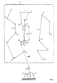
- Fig. 1 shows a larger one delimited by the dashed line Area 1, which is part of a state, for example can act.
- Area 1 which is part of a state, for example can act.
- the Tapping points 5 are, for example, within towns and can represent the department stores mentioned above.
- tour 3 between the tapping points 6 and 7, the transport vehicle 8 is shown, that on the intermediate section in the direction of the tapping point 7 moves.
- the transport vehicle 8 is with the On-board computer 9 provided to which for a radio data link serving antenna 10 is connected.
- the on-board computer 9 contains still a clock.
- the monitoring point 11 is also shown in the the central computer 12 is located, to which the antenna 13 is connected is.
- the central computer 12 are the tour schedules for the Central computer 12 monitored transport vehicles stored.
- the surveillance body can be within or outside of area 1 Area.
- the antennas 10 and 13 mentioned above Radio data connection established. 1 is in a simplified manner the radio data link as a direct connection between the antennas 10 and 13 drawn by the dashed line 18.
- the on-board computer 9 is before the start the tour of the transport vehicle 8, the tour schedule transferred been.
- 1 shows in the area of the section between the acceptance points 6 and 7 the dashed-line transport vehicle 8 ', by which Position at the point in time of the target location of the transport vehicle to be shown. Thereafter, the transport vehicle 8 is located actually compared to the target point by the distance ⁇ s and the period ⁇ t back. It is assumed that this is the case Difference value between the target value and the actual value within of the tour schedule in question is that in the on-board computer 10 recorded limit is exceeded, so that over the between the antennas 10 and 13 then established radio link the limit signal is transmitted, which is found in the transport vehicle 8 Includes location and time.
- the determination of the Location takes place in a simple manner in that under the prerequisite that the transport vehicle 8 its in the tour schedule has not left the prescribed route, for example by means of a Odometer (tachograph) determined a corresponding distance is then the location of the transport vehicle 8 within the Accuracy of the odometer defines what is normally for the Location determination is sufficient.
- Replacement tour schedule in the central computer 12 due to the in it saved tour schedules and those within area 1 for Available routes and tapping points 5 can determine which can still be reached within the relevant tour schedule Tapping points can be approached. If there are individual delivery points must be ignored, the central computer 12 this is fixed and, if necessary, obtains these transfer points in new tour schedules to be created. If necessary, that will Transport vehicle 8 as part of the replacement tour schedule (replacement tour 17) to a collection point at one of the collection points, where the goods transported by him unloaded and to another transport vehicle be handed over within a different tour schedule.
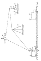
- Fig. 2 shows a schematic representation of the required message connections.
- the transport vehicle 8 is again shown with its On-board computer 9 and connected antenna 10 and the tachograph 14, controlled by one of the wheels of the transport vehicle 8 and from which a route signal is fed to the on-board computer in order to to determine the location of the transport vehicle 8 therefrom.
- Farther is the target position 8 'of the transport vehicle with dashed lines indicated. From the actual position of the transport vehicle 8 and the target position 8 'is the difference value ⁇ s relating to the distance and ⁇ t affect the time shown.
- the on-board computer 9 transfers his antenna 10 from an appropriate limit signal, which over the stationary relay point 15 and / or the satellite 16 to the monitoring point 11 arrives with the central computer 12.
- the transport vehicle can be used on request 8 determine its location.
- the location signal in question is added to the limit signal, so that the central computer 12 off the limit signal an exact message regarding the position of the Transport vehicle 8 receives and this location in the calculation of Can include replacement tour schedules.
Landscapes
- Business, Economics & Management (AREA)
- Engineering & Computer Science (AREA)
- General Physics & Mathematics (AREA)
- Economics (AREA)
- Physics & Mathematics (AREA)
- Quality & Reliability (AREA)
- Marketing (AREA)
- Operations Research (AREA)
- Human Resources & Organizations (AREA)
- Strategic Management (AREA)
- Tourism & Hospitality (AREA)
- Entrepreneurship & Innovation (AREA)
- General Business, Economics & Management (AREA)
- Development Economics (AREA)
- Theoretical Computer Science (AREA)
- Radar, Positioning & Navigation (AREA)
- Remote Sensing (AREA)
- Traffic Control Systems (AREA)
Abstract
Description
Die Erfindung bezieht sich auf ein Verfahren zur Überwachung des Transports von Gütern zu vorbestimmten Abnahmestellen mittels Transportfahrzeugen innerhalb eines räumlich ausgedehnten Gebietes, z.B. eines Staats, unter automatischer Feststellung der Fahrzeit und Rückmeldung an eine zentrale Überwachungsstelle, wobei in der Überwachungsstelle in einem Zentralrechner pro Transportfahrzeug ein individueller, Abnahmestellen enthaltender Fahrweg hinsichtlich der betreffenden Teil-Strecken, Fahr- und Standzeiten als Tourenfahrplan gespeichert wird, der einem Bordrechner im Transportfahrzeug übermittelt und in diesem als Soll-Tour gespeichert wird.The invention relates to a method for monitoring transport of goods to predetermined delivery points by means of transport vehicles within a spatially extended area, e.g. of a state, under automatic Determination of the journey time and feedback to a central monitoring point, being in the monitoring station in a central computer per transport vehicle an individual route containing delivery points with regard to the relevant sections, driving times and idle times saved as a tour schedule is transmitted to an on-board computer in the transport vehicle and in this as Target tour is saved.
Ein Verfahren zur automatischen Feststellung der jeweils zurückgelegten Wegstrecke und Erfassung dieser Wegstrecke in einem Bordrechner wird bereits in der Praxis angewendet, und zwar insbesondere von Spediteuren, die z.B. Transportfahrzeuge über längere Strecken mehrere Tage neue Möbel zu Warenhäusern antransportieren lassen. Meist ist es in derartigen Fällen erforderlich, die Abnahmestellen, also z.B. die Warenhäuser, am Tage innerhalb bestimmter Stunden anzufahren, in denen das für die Entladung zuständige Personal zur Verfügung steht. Wegen der Kosten derartiger Transporte ist es erforderlich, die jeweiligen Fahrwege so zusammenzustellen, daß das betreffende Transportfahrzeug optimal ausgenutzt wird, d.h. es sind unnötige Standzeiten soweit wie möglich zu vermeiden, wobei auch die jeweiligen Streckenverhältnisse zu berücksichtigen sind. Die Fahrer der Transportfahrzeuge dieser Spediteure erhalten normalerweise einen Tourenfahrplan, in dem dem Fahrer die Wegstrecke und die jeweiligen Zeitpunkte das An- und Abfahrens bei den einzelnen Abnahmestellen festgehalten sind. Der Fahrer hat sich nach diesem Fahrplan zu richten. Die Einhaltung des Tourenfahrplans wird jedoch häufig durch örtliche Gegebenheiten und unvorhergesehene Ereignisse, z.B. Straßenprobleme oder Wartezeiten wegen anderer Fahrzeuge an Abnahmestellen, gestört, was dann das richtige Abarbeiten des verbleibenden Restes des Tourenfahrplans unter Umständen unmöglich macht. Der Fahrer eines derart behinderten Transportfahrzeuges hat zwar normalerweise den Auftrag, Behinderungen an eine Zentrale zu melden, um gegebenenfalls von dort einen abgeänderten Tourenfahrplan zu erhalten. Eine derartige Rückfrage ist jedoch häufig für den unter Arbeits- und Zeitdruck stehenden Fahrer schwierig oder unmöglich. Außerdem ist nicht immer gewährleistet, daß in der Zentrale sofort ein abgeänderter Tourenfahrplan unter Berücksichtigung der neuen Gegebenheiten ausgearbeitet werden kann. Die Folge davon ist, daß ein derart aufgehaltenes Transportfahrzeug vorgesehene nachfolgende Abnahmestellen nicht rechtzeitig anfahren kann. Daraus resultieren Verzögerungen im weiteren Transport der Güter zu den Abnahmestellen, so daß unter Umständen vorgesehene folgende Touren nicht mehr durchgeführt werden können.A method for automatically determining the distance traveled in each case and recording this distance in an on-board computer is already in the Practice applied, in particular by freight forwarders who e.g. Transport vehicles Transport new furniture to department stores over long distances to let. In such cases, it is usually necessary to e.g. e.g. the department stores within a few hours during the day, in which the personnel responsible for unloading are available. Because of the cost of such transports, it is necessary to consider the respective routes so that the transport vehicle in question is optimally used will, i.e. unnecessary downtimes should be avoided as far as possible, the respective route conditions must also be taken into account. The driver the transport vehicles of these carriers usually get a tour schedule, in which the route and the respective times to the driver Starting and stopping at the individual delivery points are recorded. The driver has to follow this timetable. Compliance with the tour schedule however, local conditions and unforeseen events, e.g. Road problems or waiting times due to other vehicles at pick-up points, disturbed, which then the correct processing of the remaining rest of the Tour schedule may be impossible. The driver of such a handicapped Transport vehicle usually has the task of disabilities to be reported to a central office so that a modified one can be sent from there Get tour schedule. Such a query is often for the Drivers under pressure from work and time are difficult or impossible. Moreover is not always guaranteed that a modified one in the head office Tour schedule drawn up taking into account the new circumstances can be. The consequence of this is that a transport vehicle stopped in this way cannot approach the intended subsequent delivery points in time. Out of it there are delays in the further transport of the goods to the delivery points, so that the following tours may no longer be carried out can be.
In der Veröffentlichung "Internationales Verkehrswesen", April 1992, Seiten 148 bis 152 wird in dem Aufsatz "Viele Lkw-Fahrten könnten gespart werden" auf verschiedene Möglichkeiten von Leit- und Navigationssystemen zur Verbesserung des Verkehrsgeschehens im Nah- und Fernverkehr hingewiesen. Der dabei besonders herausgestellte "Travelpilot" der Firma Bosch basiert auf einer Verbindung des Fahrzeugs mit einer Verkehrsleitzentrale. Dabei werden drei unterschiedliche Konzepte erwähnt. Erstens überträgt man über einen Radio- oder Funkkanal Informationen über Straßen, die im Moment stark belegt sind, so daß ein Rechner diese von der Routenberechnung ausnimmt und einen Weg am Stau vorbei ermittelt. Die zweite Möglichkeit besteht darin, die Routensuche zentral in einem Verkehrsleitrechner durchzuführen, wobei den Fahrzeugen ständig aktualisierte Leitempfehlungen übertragen werden. Gemäß der dritten Möglichkeit werden über den UKW-Hörfunk unhörbare digitale Zusatzinformationen zum Fahrzeug übertragen und dort mittels Sprachausgabe in der jeweiligen Muttersprache ausgegeben, wodurch sich der Fahrer seinen Weg dann selbst aussuchen kann. Schließlich wird auch noch auf ein System verwiesen, wonach während der Fahrt immer nur die nächste Kreuzung dem Fahrer angezeigt wird.In the publication "Internationales Verkehrswesen", April 1992, pages 148 to 152 is in the essay "Many truck trips could be saved" on various possibilities of guidance and navigation systems for improvement of local and long-distance traffic. The one there "Travelpilot" from Bosch, which is particularly emphasized, is based on a connection of the vehicle with a traffic control center. There are three different Concepts mentioned. First, you broadcast over a radio or Radio channel information about roads that are currently heavily used, so a computer excludes them from the route calculation and a route in a traffic jam determined by. The second option is to search the route centrally in carry out a traffic control computer, the vehicles constantly updated Guiding recommendations are transferred. According to the third possibility Additional, inaudible digital information about the vehicle via FM radio transmitted and there by voice output in the respective mother tongue spent, which allows the driver to choose his own way. Finally, reference is also made to a system according to which while driving only the next intersection is shown to the driver.
Der Erfindung liegt die Aufgabe zugrunde, die oben geschilderten Schwierigkeiten zu beseitigen und im Falle von Verzögerungen dem Fahrer des betreffenden Transportfahrzeugs schnellstens einen Ersatztourenfahrplan zu ermitteln und vorzuschreiben.The invention has for its object the difficulties outlined above eliminate and in the event of delays the driver of the concerned Transport vehicle to quickly determine and prescribe a replacement tour schedule.
Erfindungsgemäß geschieht dies dadurch, daß in dem Bordrechner die Soll-Tour mit die Ist-Tour bildenden Ist-Werten verglichen wird, die als Ist-Teilstrecken und Ist-Zeitpunkte durch die Fahrt des Transportfahrzeugs und eine Uhr ermittelt werden, wobei aus dem ständigen Vergleich der Sollwerte der Soll-Tour mit den Ist-Werten ein Differenzwert ermittelt wird, der bei Überschreiten eines bestimmten Grenzwertes dem Zentralrechner über eine Datenfunkverbindung zwischen dem Transportfahrzeug und der Zentralstelle ein Grenzwertsignal übermittelt, das den im Transportfahrzeug festgestellten Standort und den betreffenden Zeitpunkt enthält, woraufhin der Zentralrechner unter Zugrundelegung des betreffenden Tourenfahrplans diesen in einen Ersatz-Tourenfahrplan abändert und diesen über die Datenfunkverbindung dem Bordrechner übermittelt, welcher Ersatz-Tourenfahrplan in der gleichen Weise hinsichtlich Soll- und Ist-Werte überwacht wird wie der ursprüngliche Tourenfahrplan.According to the invention, this is done in that the target tour in the on-board computer is compared with the actual values forming the actual tour, which are the actual partial routes and Actual times are determined by the travel of the transport vehicle and a clock, whereby from the constant comparison of the target values of the target tour with the actual values on Differential value is determined, which is exceeded when a certain Limit value to the central computer via a radio data link between transmits a limit signal to the transport vehicle and the central office, that the location determined in the transport vehicle and the contains the relevant time, whereupon the central computer under On the basis of the relevant tour schedule, this will be used in a replacement tour schedule modified and this over the radio data link On-board computer transmits which replacement tour schedule in the same In terms of target and actual values is monitored like the original Tour schedule.
Aufgrund dieser Verfahrensschritte wird die jeweilige Lage eines Transportfahrzeuges im Tourenfahrplan ständig überwacht und im Falle eines den bestimmten Grenzwert überschreitenden Abweichens der Lage des Transportfahrzeuges mittels des Grenzwertsignals wie bei einem Alarm der Zentralrechner verständigt, der dann ohne ein erforderliches Tätigwerden des Fahrers dessen Bordrechner den vom Zentralrechner ermittelten Ersatz-Tourenfahrplan übermittelt, so daß die eingetretene Verzögerung im Ablauf des Tourenfahrplans soweit wie möglich ausgeglichen wird. Im Zentralrechner ist die Lage der in Frage stehenden Abnahmestellen gespeichert, aus der er dann den günstigsten Ersatz-Tourenfahrplan errechnen kann. Auf diese Weise werden sowohl der Fahrer des betreffenden Transportfahrzeuges als auch das Personal in der Überwachungsstelle von unter Umständen komplizierten Überlegungen entlastet und trotz eingetretener Verzögerung das betreffende Transportfahrzeug optimal ausgenutzt.The respective position of a transport vehicle is determined on the basis of these procedural steps constantly monitored in the tour schedule and in the event of a deviation of the position of the Transport vehicle by means of the limit signal like an alarm the central computer communicates, which then takes no action the driver's on-board computer determined by the central computer Replacement tour schedule submitted so that the delay occurred balanced as far as possible in the course of the tour schedule becomes. The location of the tapping points in question is in the central computer saved from which he then the cheapest replacement tour schedule can calculate. In this way, both the driver of the concerned transport vehicle as well as the personnel in the monitoring station relieved of complicated considerations and despite the delay, the transport vehicle in question optimally used.
Wesentlich bei diesem Verfahren ist auch, daß die als bekannte Nachrichtenübermittlung verwendete Datenfunkverbindung nur dann in Anspruch genommen wird, wenn das Überschreiten eines bestimmten Grenzwertes im Bordrechner festgestellt wird. Einerseits werden hierdurch Kosten für die Datenfunkverbindung eingespart, andererseits diese zeitlich immer nur kurz ausgenutzt, so daß sie für viele abgewickelte Tourenfahrpläne zur Verfügung stehen kann. Ein an sich bekanntes Verfahren mit ständiger Überwachung des Standorts der Transportfahrzeuge durch ein bekanntes Satelliten-Standort-Meldesystem ist in bezug auf die Belegung der Datenfunkverbindung wesentlich aufwendiger, da ständig bzw. periodisch in relativ kurzer Zeitabständen die Standorte aller Transportfahrzeuge über Datenfunkverbindungen an die Überwachungsstelle gemeldet werden müssen, wo dann eine Vielzahl von Tourenfahrplänen daraufhin gleichzeitig überwacht werden muß, ob in einem Tourenfahrplan eine unzulässige Abweichung festgestellt wird oder nicht.It is also essential in this method that the known as message transmission only used radio data connection is taken when exceeding a certain limit is determined in the on-board computer. On the one hand, this will Costs for the radio data link saved, on the other hand this time Always used only briefly, so that they are used for many tour schedules can be available. A known method with constant monitoring of the location of the transport vehicles by a known satellite location reporting system is in terms of occupancy the radio data link is much more complex because it is constant or periodic the locations of all transport vehicles at relatively short intervals reported to the monitoring station via radio data links where there are a variety of tour schedules at the same time, it must be monitored whether a route schedule has a impermissible deviation is determined or not.
Um bei Feststellung einer zu großen Abweichung vom Touren-Fahrplan sicherzustellen, daß für die Erstellung des Ersatz-Tourenfahrplans auch die exakte Lage des betreffenden Transportfahrzeuges berücksichtigt wird, geht man zweckmäßig so vor, daß beim Überschreiten des Grenzwertes eine Satelliten-Standort-Meldung im Bordrechner registriert und dem Grenzwertsignal diese Standort-Meldung hinzugefügt wird, die in die Erstellung des Ersatz-Tourenfahrplans einbezogen wird. Diese Standort-Meldung ist also nur beim Überschreiten des Grenzwertes erforderlich. Die vom Transportfahrzeug aus initiierte Satelliten-Standort-Meldung, also die vom Transportfahrzeug ausgelöste Anfrage beim Satelliten hinsichtlich des Standorts des Transportfahrzeuges, ist bei der heute verfügbaren Satellitentechnik mit keinerlei Kosten verbunden, da die bereits existierenden Satelliten den Standort einer anfragenden Stelle kostenlos bestimmen und übermitteln. Im Falle der ständigen Überwachung des Standortes der Transportfahrzeuge in einer Überwachungsstelle über einen Satelliten muß auf Anfrage von der Überwachungsstelle her der Satellit das jeweils gesuchte Transportfahrzeug erst ermitteln, um daraufhin dessen Standort der Überwachungsstelle mitzuteilen, was kostenpflichtig ist.To determine if there is too great a deviation from the tour schedule ensure that for the creation of the replacement tour schedule as well the exact location of the transport vehicle in question is taken into account, one expediently proceeds in such a way that when the limit value is exceeded a satellite location report registered in the on-board computer and the Limit signal this location message is added, which in the Creation of the replacement tour schedule is included. This location report is only necessary when the limit is exceeded. The satellite location report initiated by the transport vehicle, that is the request from the transport vehicle to the satellite regarding the location of the transport vehicle is at that available today Satellite technology at no cost because the existing ones Satellites determine the location of a requesting agency free of charge and submit. In the case of constant monitoring of the location of the transport vehicles in a monitoring station via a The satellite must request the satellite from the monitoring station first determine the transport vehicle you are looking for and then the location of the monitoring body to tell what is chargeable is.
Das Verfahren läßt sich dahingehend ausgestalten, daß es eine ständige Optimierung der im Zentralrechner gespeicherten Tourenfahrpläne und Straßennetze hinsichtlich Streckenlänge und Fahrzeit gestattet. Dies geschieht dadurch, daß laufend Satelliten-Standort-Meldungen mit den zugehörigen Zeitpunkten im Bordrechner registriert und dem Zentralrechner zugeführt werden, der diese Daten mit den Daten der betreffenden Soll-Tour oder deren Teilstrecken vergleicht und aufgrund mehrerer Meldungen für die gleichen Ist-Touren bzw. Ist-Teil-Strecken die Soll-Strecken (Entfernungen und Zeiten) den Ist-Strecken anpaßt. Die hierbei erforderlichen Satelliten-Standort-Meldungen werden vom jeweiligen Transportfahrzeug ausgelöst, das wie oben bereits dargelegt, die Standortmeldungen kostenlos erhält und diese dann im Bordrechner registrieren kann. Von dort werden die betreffenden Daten dem Zentralrechner zugeführt, entweder von Zeit zu Zeit über die Datenfunkverbindung oder nach Abwicklung des betreffenden Tourenfahrplans. Im Zentralrechner kann dann durch Vergleich einer Mehrzahl von abgewickelten gleichen Tourenfahrplänen festgestellt werden, ob sich dabei häufig gewisse Abweichungen vom gespeicherten Tourenfahrplan ergeben. In diesem Falle läßt sich dann ohne weiteres der gespeicherte Tourenfahrplan an die wiederholt auftretenden, praxisbedingten Abweichungen anpassen, womit ein entsprechend optimierter Tourenfahrplan erstellt wird.The process can be designed so that it is a constant Optimization of the tour timetables and stored in the central computer Road networks permitted in terms of route length and travel time. This happens by continuously reporting satellite location with the associated times are registered in the on-board computer and the central computer are supplied, this data with the data of the concerned Comparing the target tour or its sections and based on several Messages for the same actual tours or actual partial routes the target routes (Distances and times) adapts to the actual routes. The one here required satellite location reports are provided by the respective Transport vehicle triggered, as already explained above, the location reports receive free of charge and then register them in the on-board computer can. From there, the relevant data is sent to the central computer supplied, either from time to time via the radio data link or after completion of the relevant tour schedule. In the central computer can then be compared by comparing a plurality of processed Tour schedules determine whether there are often certain deviations from the saved tour schedule. In this case the saved tour schedule can then be sent to the adjust repetitive, practice-related deviations, with what a correspondingly optimized tour schedule is created.
Anhand der Figuren sei ein Ausführungsbeispiel der Erfindung erläutert.
Es zeigen
Show it
Fig. 1 zeigt ein durch die gestrichelte Linie eingegrenztes größeres
Gebiet 1, bei dem es sich zum Beispiel um einen Teil eines Staats
handeln kann. In diesem Gebiet sind 3 Touren, 2, 3 und 4 eingezeichnet,
die über Teilstrecken zwischen Abnahmestellen 5 verlaufen. Die
Abnahmestellen 5 liegen zum Beispiel innerhalb von Ortschaften und
können die obenerwähnten Warenhäuser darstellen. In der Tour 3 zwischen
den Abnahmestellen 6 und 7 ist das Transportfahrzeug 8 dargestellt,
daß sich auf der dazwischen liegende Teilstrecke in Richtung auf
die Abnahmestelle 7 zu bewegt. Das Transportfahrzeug 8 ist mit dem
Bordrechner 9 versehen, an den die für eine Datenfunkverbindung
dienende Antenne 10 angeschlossen ist. Der Bordrechner 9 enthält
weiterhin eine Uhr.Fig. 1 shows a larger one delimited by the
In der Fig. 1 ist weiterhin die Überwachungsstelle 11 dargestellt, in der
sich der Zentralrechner 12 befindet, an den die Antenne 13 angeschlossen
ist. In dem Zentralrechner 12 sind die Tourenfahrpläne für die vom
Zentralrechner 12 überwachten Transportfahrzeuge gespeichert. Die Überwachungsstelle
kann sich innerhalb des Gebietes 1 oder außerhalb dieses
Gebietes befinden. Über die Antennen 10 und 13 wird die oben erwähnte
Datenfunkverbindung hergestellt. In Fig. 1 ist in vereinfachter Weise
die Datenfunkverbindung als direkte Verbindung zwischen den Antennen
10 und 13 durch die gestrichelte Linie 18 gezeichnet. Normalerweise ist
jedoch zwischen die Überwachungsstelle 11 und die einzelne Transportfahrzeuge
8 eine oder mehrere Relaisfunkstellen eingeschaltet, was
normalerweise wegen der üblicherweise erheblichen räumlichen Ausdehnung
des Gebiets 1 erforderlich ist. In den Bordrechner 9 ist vor Beginn
der Tour des Transportfahrzeugs 8 der betr. Tourenfahrplan überspielt
worden.In Fig. 1, the
Fig. 1 zeigt im Bereich der Teilstrecke zwischen den Annahmestellen 6
und 7 das gestrichelt gezeichnete Transportfahrzeug 8', durch dessen
Lage in dem betreffenden Zeitpunkt die Soll-Stelle des Transportfahrzeuges
gezeigt werden soll. Danach liegt also das Transportfahrzeug 8
tatsächlich gegenüber der Soll-Stelle um die Strecke Δs und den Zeitraum
Δt zurück. Es sei angenommen, daß es sich dabei um einen derartigen
Differenzwert zwischen dem Soll-Wert und dem Ist-Wert innerhalb
des betreffenden Tourenfahrplans handelt, daß der im Bordrechner
10 festgehaltene Grenzwert überschritten wird, so daß über die zwischen
den Antennen 10 und 13 dann erstellte Datenfunkverbindung das Grenzwertsignal
übermittelt wird, das den im Transportfahrzeug 8 festgestellten
Standort und den betreffenden Zeitpunkt enthält. Die Ermittlung des
Standorts erfolgt dabei in einfacher Weise dadurch, daß unter der Vorraussetzung,
daß das Transportfahrzeug 8 seinen im Tourenfahrplan
vorgeschriebenen Weg nicht verlassen hat, beispielsweise mittels eines
Kilometerzählers (Tachograph) eine entsprechende Wegstrecke festgestellt
wird, die dann den Standort des Transportfahrzeuges 8 innerhalb der
Genauigkeit des Kilometerzählers definiert, was normalerweise für die
Standortbestimmung ausreichend ist.1 shows in the area of the section between the
Es erfolgt dann in der oben geschriebenen Weise eine Ermittlung eines
Ersatz-Tourenfahrplans im Zentralrechner 12, der aufgrund der in ihm
gespeicherten Tourenfahrpläne und der innerhalb des Gebietes 1 zur
Verfügung stehenden Fahrstrecken und Abnahmestellen 5 ermitteln kann,
welche innerhalb des betreffenden Tourenfahrplans noch erreichbaren
Abnahmestellen angefahren werden können. Wenn dabei einzelne Abnahmestellen
übergangen werden müssen, so hält der Zentralrechner 12
dies fest und bezieht diese übergangenen Abnahmestellen gegebenenfalls
in neu zu erstellende Tourenfahrpläne ein. Gegebenenfalls wird das
Transportfahrzeug 8 im Rahmen des Ersatz-Tourenfahrplans (Ersatz-Tour
17) zu einer Sammelstelle an einer der Abnahmestellen geführt, wo die
von ihm transportierten Güter abgeladen und an ein anderes Transportfahrzeug
innerhalb eines anderen Tourenfahrplanes übergeben werden.A determination is then made in the manner described above
Replacement tour schedule in the
Fig. 2 zeigt in schematischer Darstellung die erforderlichen Nachrichtenverbindungen.
Gezeigt ist wieder das Transportfahrzeug 8 mit seinem
Bordrechner 9 und angeschlossener Antenne 10 sowie den Tachographen
14, der von einem der Räder des Transportfahrzeuges 8 gesteuert und
von dem ein Wegstreckensignal dem Bordrechner zugeführt wird, um
daraus den Standort des Transportfahrzeugs 8 zu bestimmen. Weiterhin
ist die Soll-Lage 8' des Transportfahrzeuges mit gestrichelten Linien
angedeutet. Aus der Ist-Lage des Transportfahrzeuges 8 und der Soll-Lage
8' ist der Differenzwert Δs betreffend die Wegstrecke und Δt
betreffen den Zeitpunkt dargestellt. Wenn es sich, wie angenommen wird,
dabei um das Überschreiten des bestimmten Grenzwertes handelt, den
der Bordrechner 9 gespeichert hat, dann gibt der Bordrechner 9 über
seine Antenne 10 ein einsprechendes Grenzwertsignal ab, das über die
stationäre Relaisstelle 15 und/oder den Satelliten 16 zu der Überwachungsstelle
11 mit dem Zentralrechner 12 gelangt.Fig. 2 shows a schematic representation of the required message connections.
The
Mittels des Satelliten 16 läßt sich auf Anfrage von dem Transportfahrzeug
8 her dessen Standort bestimmen. Das betreffende Standortsignal
wird dem Grenzwertsignal hinzugefügt, so daß der Zentralrechner 12 aus
dem Grenzwertsignal eine exakte Meldung hinsichtlich der Lage des
Transportfahrzeuges 8 erhält und diese Lage in die Errechnung des
Ersatz-Tourenfahrplans einbeziehen kann.By means of the
Claims (3)
- Method of monitoring the transport of goods to predetermined receiving points (5, 6, 7) by means of transport vehicles (8) within a physically extensive region (1), e.g. a country, with automatic determination of the travelling time and feedback to a central monitoring point (11), an individual travel plan with regard to the relevant part-sections, travelling and standing times and containing receiving points (5) being stored for each transport vehicle (8) in a central computer (12) in the monitoring point (11) as a route travel plan, being transmitted to an on-board computer (9) in the transport vehicle (8) and stored in the latter as a desired route, the desired route being compared in the on-board computer with the actual values which form the actual route, which are determined as actual part-sections and actual times by means of the travel of the transport vehicle (8) and a clock, the continual comparison of the desired values of the desired route with the actual values being used to determine a difference value which, if a specific limiting value is exceeded, a limiting-value signal is transmitted to the central computer (12) via a radio data link (10, 15, 16, 13) between the transport vehicle (8) and the central point (11), the said limiting-value signal containing the location determined in the transport vehicle (8) and the relevant time, whereupon the central computer (12) uses the relevant route travel plan as a basis to modify the latter into a substitute route travel plan (17) and transmits the latter via the radio data link (13, 15, 16, 10) to the on-board computer, the substitute route travel plan being monitored in the same way as the original route travel plan with regard to the desired and actual values.
- Method according to Claim 1, characterized in that if the limiting value is exceeded, a satellite location message is registered in the on-board computer (9), and the limiting-value signal is appended to this location message, which is used in drawing up the substitute route travel plan.
- Method according to Claim 1 or 2, characterized in that satellite location messages together with the associated times are registered continuously in the on-board computer (9) and supplied to the central computer (12), which compares these data with the data of the relevant desired route or its part-sections and, on the basis of a plurality of messages for the same actual routes or actual part-sections, adapts the desired sections to the actual sections.
Applications Claiming Priority (2)
| Application Number | Priority Date | Filing Date | Title |
|---|---|---|---|
| DE4214067 | 1992-04-29 | ||
| DE4214067A DE4214067C2 (en) | 1992-04-29 | 1992-04-29 | Process for monitoring the transport of goods to predetermined delivery points |
Publications (3)
| Publication Number | Publication Date |
|---|---|
| EP0567992A2 EP0567992A2 (en) | 1993-11-03 |
| EP0567992A3 EP0567992A3 (en) | 1994-04-27 |
| EP0567992B1 true EP0567992B1 (en) | 2001-10-10 |
Family
ID=6457731
Family Applications (1)
| Application Number | Title | Priority Date | Filing Date |
|---|---|---|---|
| EP93106792A Expired - Lifetime EP0567992B1 (en) | 1992-04-29 | 1993-04-27 | Method for monitoring the transport of goods to predetermined removal stations |
Country Status (3)
| Country | Link |
|---|---|
| EP (1) | EP0567992B1 (en) |
| AT (1) | ATE206832T1 (en) |
| DE (1) | DE4214067C2 (en) |
Families Citing this family (23)
| Publication number | Priority date | Publication date | Assignee | Title |
|---|---|---|---|---|
| JPH08512420A (en) * | 1994-05-06 | 1996-12-24 | フィリップス エレクトロニクス ネムローゼ フェンノートシャップ | Method and apparatus for locating a vehicle based on internal changes in state |
| DE19513640C2 (en) * | 1994-11-28 | 1997-08-07 | Mannesmann Ag | Method for reducing the amount of data to be transmitted from the vehicles of a vehicle fleet |
| CZ288054B6 (en) * | 1995-04-06 | 2001-04-11 | Detemobil Deutsche Telekom Mobilnet Gmbh | Data processing method for vehicle control and information system |
| US5694322A (en) † | 1995-05-09 | 1997-12-02 | Highwaymaster Communications, Inc. | Method and apparatus for determining tax of a vehicle |
| DE19539641C2 (en) * | 1995-10-25 | 2000-02-17 | Daimler Chrysler Ag | Method and device for traffic situation-dependent vehicle route guidance |
| JPH09198439A (en) * | 1996-01-22 | 1997-07-31 | Toyota Motor Corp | Travel plan preparation system |
| JP3125669B2 (en) * | 1996-01-31 | 2001-01-22 | トヨタ自動車株式会社 | Travel planning equipment |
| DE19621424A1 (en) * | 1996-05-28 | 1997-12-04 | Telemedia Gmbh | Scanned data selection method for momentary vehicle position |
| DE19646954B4 (en) * | 1996-11-13 | 2006-09-21 | T-Mobile Deutschland Gmbh | Method and device for controlling a fleet of land and / or water vehicles |
| DE19726542B4 (en) * | 1997-05-07 | 2004-04-22 | Schwanhäußer, Wulf, Prof. Dr.-Ing. | Process for controlling and securing a timetable-based traffic system |
| DE19721145A1 (en) * | 1997-05-21 | 1998-11-26 | Alsthom Cge Alcatel | Public transport carrying out method |
| DE19732371A1 (en) * | 1997-06-06 | 1998-12-10 | Volkswagen Ag | Method of controlling road vehicles using route planner |
| DE19747446A1 (en) | 1997-10-28 | 1999-04-29 | Cit Alcatel | Controlling bus-stop or tram-stop displays |
| DE19755142B4 (en) * | 1997-11-28 | 2004-03-18 | Krönke, Matthias | Method and system for transport and position monitoring of moving objects |
| FR2789503B1 (en) * | 1999-02-05 | 2001-10-19 | Lambilly Antoine De | ON-BOARD METHOD AND DEVICE FOR TRACKING THE SERVICING OF A DEFINED ROUTE |
| DE19946162A1 (en) | 1999-09-27 | 2001-04-05 | Siemens Ag | Arrangement and method for route guidance using a communication network, in particular a mobile radio network |
| DE19949622A1 (en) * | 1999-10-14 | 2001-05-10 | Asam Robert | Mobile route monitoring unit |
| EP1103908A3 (en) * | 1999-11-19 | 2003-05-21 | Rolf-Georg Brockmans | Control- and monitoring system for the verification of object-related actions and transactions having legal character |
| US7079945B1 (en) | 2001-04-17 | 2006-07-18 | Navteq North America, Llc | Geographic database including data indicating wireless coverage and method and system for use thereof |
| US6725156B2 (en) | 2001-05-10 | 2004-04-20 | Navigation Technologies Corp. | Method and system for providing backup driving instructions with a navigation system |
| DE10130279B4 (en) * | 2001-06-26 | 2005-04-21 | Btt Bahn Tank Transport Gmbh Deutsche Bahn Gruppe | Method for a computer-controlled transport management system with precalculation of the time behavior of product values |
| EP1294162A1 (en) * | 2001-09-14 | 2003-03-19 | Siemens Aktiengesellschaft | Verfahren und System zur Kommunikation mit Reisenden |
| CN111856541B (en) * | 2020-07-24 | 2023-11-14 | 苏州中亿通智能系统有限公司 | Fixed line vehicle track monitoring system and method |
Family Cites Families (3)
| Publication number | Priority date | Publication date | Assignee | Title |
|---|---|---|---|---|
| DE3872750D1 (en) * | 1987-04-24 | 1992-08-20 | Siemens Ag | TRANSPORT AND TRAFFIC GUIDE SYSTEM. |
| DE3932029A1 (en) * | 1988-12-15 | 1990-06-28 | Sven Dipl Ing Haase | Position recognition device for vehicles in monitor zone - has separate position transmitters received and reradiated by vehicle along with marker |
| DE4032198C2 (en) * | 1990-10-11 | 1995-10-19 | Daimler Benz Aerospace Ag | Transport monitoring method and arrangement for carrying out the method |
-
1992
- 1992-04-29 DE DE4214067A patent/DE4214067C2/en not_active Expired - Fee Related
-
1993
- 1993-04-27 EP EP93106792A patent/EP0567992B1/en not_active Expired - Lifetime
- 1993-04-27 AT AT93106792T patent/ATE206832T1/en not_active IP Right Cessation
Also Published As
| Publication number | Publication date |
|---|---|
| DE4214067A1 (en) | 1993-11-04 |
| DE4214067C2 (en) | 1995-08-31 |
| EP0567992A3 (en) | 1994-04-27 |
| EP0567992A2 (en) | 1993-11-03 |
| ATE206832T1 (en) | 2001-10-15 |
Similar Documents
| Publication | Publication Date | Title |
|---|---|---|
| EP0567992B1 (en) | Method for monitoring the transport of goods to predetermined removal stations | |
| DE69926049T2 (en) | AUTOMATIC EVENT DETECTION DEVICE AND METHOD IN A WIRELESS MESSAGE TRANSMISSION SYSTEM | |
| DE60027099T2 (en) | Method for broadcasting information | |
| EP1026649B1 (en) | Method and device to prepare traffic information | |
| DE60020065T2 (en) | PAPER-FREE OPERATING DATA ACQUISITION SYSTEM AND METHOD | |
| DE3930425C2 (en) | Method for controlling the movement of transport vehicles | |
| EP0819295B1 (en) | Process for a vehicle control and information system | |
| EP1485897B1 (en) | Automatic vehicle guidance method and system | |
| EP0752692B1 (en) | Method and system for updating digital road maps | |
| DE19646954B4 (en) | Method and device for controlling a fleet of land and / or water vehicles | |
| DE19912859A1 (en) | Communication compatible navigation system for automobiles | |
| DE102007046765A1 (en) | Control procedure and system | |
| EP1072862A1 (en) | Navigation method and device | |
| DE102006017845A1 (en) | Reservable parking bay finding/reserving system for e.g. lorry, has terminals temporarily connected with central server for data exchange and enabling transmission of reservation request and reception of booking option | |
| WO2003107301A1 (en) | Navigation system for a vehicle | |
| EP1466140B1 (en) | Method for determining a travel time | |
| DE19740602A1 (en) | Traffic control, information and positioning system | |
| EP0803852A1 (en) | Method and device to guide a vehicle | |
| DE102012215447A1 (en) | Centralized route determination | |
| DE4331431C1 (en) | Traffic control device for controlling the driving operation and the traffic flow for the rail-bound traffic | |
| DE19824272B4 (en) | Method for detecting the traffic condition on roads and highways and stationary and mobile device for carrying it out | |
| WO2018171991A1 (en) | Method for remotely controlling a plurality of driverless self-driving systems, control station for remotely controlling the self-driving systems, and system | |
| DE102019200149A1 (en) | Control unit, an at least partially automated vehicle, a vehicle group and a method | |
| EP1402497B1 (en) | System and method for providing travel-guiding information on a mobile communication device | |
| EP1935749B1 (en) | Method and system for fixing the position of a railway vehicle |
Legal Events
| Date | Code | Title | Description |
|---|---|---|---|
| PUAI | Public reference made under article 153(3) epc to a published international application that has entered the european phase |
Free format text: ORIGINAL CODE: 0009012 |
|
| AK | Designated contracting states |
Kind code of ref document: A2 Designated state(s): AT DE ES FR IT NL SE |
|
| PUAL | Search report despatched |
Free format text: ORIGINAL CODE: 0009013 |
|
| AK | Designated contracting states |
Kind code of ref document: A3 Designated state(s): AT DE ES FR IT NL SE |
|
| 17P | Request for examination filed |
Effective date: 19941027 |
|
| 17Q | First examination report despatched |
Effective date: 19980827 |
|
| RAP1 | Party data changed (applicant data changed or rights of an application transferred) |
Owner name: WANKO UNTERNEHMENSLOGISTIK GMBH |
|
| RIN1 | Information on inventor provided before grant (corrected) |
Inventor name: WANKO, HEINRICH |
|
| RIC1 | Information provided on ipc code assigned before grant |
Free format text: 7G 06F 17/60 A, 7G 08G 1/127 B |
|
| GRAG | Despatch of communication of intention to grant |
Free format text: ORIGINAL CODE: EPIDOS AGRA |
|
| GRAG | Despatch of communication of intention to grant |
Free format text: ORIGINAL CODE: EPIDOS AGRA |
|
| GRAH | Despatch of communication of intention to grant a patent |
Free format text: ORIGINAL CODE: EPIDOS IGRA |
|
| GRAH | Despatch of communication of intention to grant a patent |
Free format text: ORIGINAL CODE: EPIDOS IGRA |
|
| RBV | Designated contracting states (corrected) |
Designated state(s): AT ES FR IT NL SE |
|
| REG | Reference to a national code |
Ref country code: DE Ref legal event code: 8566 |
|
| GRAA | (expected) grant |
Free format text: ORIGINAL CODE: 0009210 |
|
| AK | Designated contracting states |
Kind code of ref document: B1 Designated state(s): AT ES FR IT NL SE |
|
| PG25 | Lapsed in a contracting state [announced via postgrant information from national office to epo] |
Ref country code: IT Free format text: LAPSE BECAUSE OF FAILURE TO SUBMIT A TRANSLATION OF THE DESCRIPTION OR TO PAY THE FEE WITHIN THE PRESCRIBED TIME-LIMIT;WARNING: LAPSES OF ITALIAN PATENTS WITH EFFECTIVE DATE BEFORE 2007 MAY HAVE OCCURRED AT ANY TIME BEFORE 2007. THE CORRECT EFFECTIVE DATE MAY BE DIFFERENT FROM THE ONE RECORDED. Effective date: 20011010 Ref country code: FR Free format text: LAPSE BECAUSE OF FAILURE TO SUBMIT A TRANSLATION OF THE DESCRIPTION OR TO PAY THE FEE WITHIN THE PRESCRIBED TIME-LIMIT Effective date: 20011010 |
|
| REF | Corresponds to: |
Ref document number: 206832 Country of ref document: AT Date of ref document: 20011015 Kind code of ref document: T |
|
| PG25 | Lapsed in a contracting state [announced via postgrant information from national office to epo] |
Ref country code: SE Free format text: LAPSE BECAUSE OF FAILURE TO SUBMIT A TRANSLATION OF THE DESCRIPTION OR TO PAY THE FEE WITHIN THE PRESCRIBED TIME-LIMIT Effective date: 20020110 |
|
| PG25 | Lapsed in a contracting state [announced via postgrant information from national office to epo] |
Ref country code: ES Free format text: LAPSE BECAUSE OF FAILURE TO SUBMIT A TRANSLATION OF THE DESCRIPTION OR TO PAY THE FEE WITHIN THE PRESCRIBED TIME-LIMIT Effective date: 20020430 |
|
| EN | Fr: translation not filed | ||
| PLBE | No opposition filed within time limit |
Free format text: ORIGINAL CODE: 0009261 |
|
| STAA | Information on the status of an ep patent application or granted ep patent |
Free format text: STATUS: NO OPPOSITION FILED WITHIN TIME LIMIT |
|
| 26N | No opposition filed | ||
| PGFP | Annual fee paid to national office [announced via postgrant information from national office to epo] |
Ref country code: NL Payment date: 20041013 Year of fee payment: 12 |
|
| PGFP | Annual fee paid to national office [announced via postgrant information from national office to epo] |
Ref country code: AT Payment date: 20041022 Year of fee payment: 12 |
|
| PG25 | Lapsed in a contracting state [announced via postgrant information from national office to epo] |
Ref country code: AT Free format text: LAPSE BECAUSE OF NON-PAYMENT OF DUE FEES Effective date: 20050427 |
|
| PG25 | Lapsed in a contracting state [announced via postgrant information from national office to epo] |
Ref country code: NL Free format text: LAPSE BECAUSE OF NON-PAYMENT OF DUE FEES Effective date: 20051101 |
|
| NLV4 | Nl: lapsed or anulled due to non-payment of the annual fee |
Effective date: 20051101 |