EP0219680A1 - Vehicle navigation device - Google Patents
Vehicle navigation device Download PDFInfo
- Publication number
- EP0219680A1 EP0219680A1 EP86112710A EP86112710A EP0219680A1 EP 0219680 A1 EP0219680 A1 EP 0219680A1 EP 86112710 A EP86112710 A EP 86112710A EP 86112710 A EP86112710 A EP 86112710A EP 0219680 A1 EP0219680 A1 EP 0219680A1
- Authority
- EP
- European Patent Office
- Prior art keywords
- navigation system
- vehicle navigation
- vehicle
- location
- speed
- Prior art date
- Legal status (The legal status is an assumption and is not a legal conclusion. Google has not performed a legal analysis and makes no representation as to the accuracy of the status listed.)
- Withdrawn
Links
Images
Classifications
-
- F—MECHANICAL ENGINEERING; LIGHTING; HEATING; WEAPONS; BLASTING
- F41—WEAPONS
- F41G—WEAPON SIGHTS; AIMING
- F41G5/00—Elevating or traversing control systems for guns
- F41G5/14—Elevating or traversing control systems for guns for vehicle-borne guns
-
- G—PHYSICS
- G01—MEASURING; TESTING
- G01C—MEASURING DISTANCES, LEVELS OR BEARINGS; SURVEYING; NAVIGATION; GYROSCOPIC INSTRUMENTS; PHOTOGRAMMETRY OR VIDEOGRAMMETRY
- G01C21/00—Navigation; Navigational instruments not provided for in groups G01C1/00 - G01C19/00
- G01C21/10—Navigation; Navigational instruments not provided for in groups G01C1/00 - G01C19/00 by using measurements of speed or acceleration
- G01C21/12—Navigation; Navigational instruments not provided for in groups G01C1/00 - G01C19/00 by using measurements of speed or acceleration executed aboard the object being navigated; Dead reckoning
- G01C21/14—Navigation; Navigational instruments not provided for in groups G01C1/00 - G01C19/00 by using measurements of speed or acceleration executed aboard the object being navigated; Dead reckoning by recording the course traversed by the object
Definitions
- the invention relates to a vehicle navigation system with a device for determining the course angle and the route for orienting the vehicle used as a carrier of a weapon system in the battlefield.
- Vehicle navigation systems are used to determine location in unknown terrain.
- the navigation data contain the heading angle and the distance traveled by the vehicle from a reference direction or reference point.
- the accuracy that can be achieved when measuring the distance by counting the number of revolutions of the drive axis is considered sufficient.
- the target assignment to mobile weapon systems operating in a battlefield by a central location with a round search sensor is only useful if the location of the weapon system in relation to the location of the round search sensor is known.
- the location coordinates can be used to transform the target data of the search sensor to the location of the weapon system.
- the invention has for its object to enable the connection of the weapon system to an assigned target with little additional effort in an arrangement of the type mentioned. According to the invention, this object is achieved in that with the own NEN vehicle navigation system determined location coordinates are used in addition to performing the transformation of the target data supplied by a central location of an enemy object.
- the accuracy of the distance measurement of a vehicle navigation system can possibly be due to the drive means slipping against the ground. considerably reduced and unsuitable for a transformation of the target data.
- a larger difference between the measured and the actual location significantly reduces the probability of activation when instructing the weapon system.
- the effect of the slip on the location determination is completely eliminated by continuously measuring the speed of the vehicle each time the location is changed and integrating it into the path actually traveled in an integration circuit that is part of a data processing device.
- the vehicle speed can be determined by means of a radar or laser sensor working with the Doppler effect.
- the vehicle speed data obtained continuously via the radar or laser sensor are advantageously entered into a data processing system together with the heading angle supplied by the vehicle navigation system, and the distance traveled, the coordinate values x and y, is calculated from these values.
- the data processing system can be a component of the vehicle navigation system.
- FIGS. 1 and 2 Embodiment explained in more detail in the essential parts.
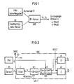
- a vehicle navigation system FNA as is used in a known manner for determining the location of vehicles in the battlefield, and a radar or laser sensor RS, which is arranged on the vehicle and continuously detects the vehicle speed against the ground, provide the necessary data for an exact calculation of the location coordinates.
- a data processing device DVE only accepts the heading angle of the vehicle navigation system FNA and the speed value v of the sensor RS.
- the values of the current speed measurements are integrated into the distance actually traveled. As a result, exact location coordinates are obtained with which the transformation of the assigned target data, based on the location of the weapon system, can be carried out.
- the structure and function of the data processing unit is described on a block diagram in FIG. 2.
- the vehicle speed v supplied by the speed sensor RS passes through a filter F before processing.
- the path segments covered in x and y are calculated from the heading angle and absolute distance by multiplication with the trigonometric functions sin, cos in a further multiplier M2.
- the total distances in x and y result from the integration or summation over ⁇ Sx, ⁇ Sy in the adders A1 and A2.
Abstract
Description
Die Erfindung bezieht sich auf eine Fahrzeugnavigationsanlage mit einer Einrichtung zur Bestimmung des Kurswinkels und der Fahrstrecke zur Orientierung des als Träger eines Waffensystems eingesetzten Fahrzeuges im Gefechtsfeld.The invention relates to a vehicle navigation system with a device for determining the course angle and the route for orienting the vehicle used as a carrier of a weapon system in the battlefield.
Fahrzeugnavigationsanlagen sind zur Ortsbestimmung in unbekanntem Gelände eingesetzt. Die Navigationsdaten enthalten den Kurswinkel und die gefahrene Wegstrecke des Fahrzeuges von einer Bezugsrichtung bzw. Bezugspunkt ausgemessen. Die bei Wegstreckenmessung mittels Zählung der Umdrehungszahl der Antriebsachse erzielbare Genauigkeit wird als ausreichend angesehen.Vehicle navigation systems are used to determine location in unknown terrain. The navigation data contain the heading angle and the distance traveled by the vehicle from a reference direction or reference point. The accuracy that can be achieved when measuring the distance by counting the number of revolutions of the drive axis is considered sufficient.
Die Zielzuweisung an in einem Gefechtsfeld operierende mobile Waffensysteme durch eine zentrale Stelle mit einem Rundsuchsensor ist nur dann sinnvoll, wenn der Standort des Waffensystems bezogen auf den Standort des Rundsuchsensors bekannt ist. Mit den Standortkoordinaten kann eine Transformation der Zieldaten des Rundsuchsensors auf den Standort des Waffensystems vorgenommen werden.The target assignment to mobile weapon systems operating in a battlefield by a central location with a round search sensor is only useful if the location of the weapon system in relation to the location of the round search sensor is known. The location coordinates can be used to transform the target data of the search sensor to the location of the weapon system.
Der Erfindung liegt die Aufgabe zugrunde, bei einer Anordnung der eingangs genannten Art die Aufschaltung des Waffensystems auf ein zugewiesenes Ziel mit geringem zusätzlichen Aufwand zu ermöglichen. Gemäß der Erfindung wird diese Aufgabe dadurch gelöst, daß die mit der eige nen Fahrzeugnavigationsanlage ermittelten Standortkoordinaten zusätzlich zur Durchführung der Transformation der von einer zentralen Stelle gelieferten Zieldaten eines feindlichen Objektes in Anspruch genommen werden.The invention has for its object to enable the connection of the weapon system to an assigned target with little additional effort in an arrangement of the type mentioned. According to the invention, this object is achieved in that with the own NEN vehicle navigation system determined location coordinates are used in addition to performing the transformation of the target data supplied by a central location of an enemy object.
Vor allem die Genauigkeit der Wegstreckenmessung einer Fahrzeugnavigationsanlage kann jedoch aufgrund des Schlupfes der Antriebsmittel gegenüber dem Erdboden u.U. erheblich vermindert und für eine Transformation der Zieldaten ungeeignet sein. Ein größerer Unterschied zwischen dem gemessenem und dem tatsächlichen Standort verringert die Aufschaltwahrscheinlichkeit bei der Einweisung des Waffensystems deutlich. Gemäß einer vorteilhaften Weiterbildung der Erfindung wird die Auswirkung des Schlupfes auf die Standortbestimmung dadurch völlig ausgeschaltet, daß bei jeder Standortänderung die Geschwindigkeit des Fahrzeuges laufend ständig gemessen und in einer Integrationsschaltung, die Teil einer Datenverarbeitungseinrichtung ist, zum tatsächlich zurückgelegten Weg aufintegriert wird.Above all, however, the accuracy of the distance measurement of a vehicle navigation system can possibly be due to the drive means slipping against the ground. considerably reduced and unsuitable for a transformation of the target data. A larger difference between the measured and the actual location significantly reduces the probability of activation when instructing the weapon system. According to an advantageous development of the invention, the effect of the slip on the location determination is completely eliminated by continuously measuring the speed of the vehicle each time the location is changed and integrating it into the path actually traveled in an integration circuit that is part of a data processing device.
Gemäß einer weiteren vorteilhaften Weiterbildung der Erfindung kann die Fahrzeuggeschwindigkeit mittels eines mit dem Dopplereffekt arbeitenden Radar- oder Lasersensors ermittelt werden. Die über den Radar- bzw. Lasersensor laufend erhaltenen Geschwindigkeitsdaten des Fahrzeuges werden vorteilhafterweise zusammen mit dem von der Fahrzeugnavigationsanlage gelieferten Kurswinkel in eine Datenverarbeitungsanlage eingegeben und aus diesen Werten der zurückgelegte Weg den Koordinatenwerten x und y berechnet. Dabei kann die Datenverarbeitungsanlage ein Bestandteil der Fahrzeugnavigationsanlage sein.According to a further advantageous development of the invention, the vehicle speed can be determined by means of a radar or laser sensor working with the Doppler effect. The vehicle speed data obtained continuously via the radar or laser sensor are advantageously entered into a data processing system together with the heading angle supplied by the vehicle navigation system, and the distance traveled, the coordinate values x and y, is calculated from these values. The data processing system can be a component of the vehicle navigation system.
Die Erfindung und weitere Einzelheiten der Erfindung werden anhand eines in den Fig. 1und 2 dargestellten Ausführungsbeispieles in den wesentlichen Teilen näher erläutert.The invention and further details of the invention are illustrated by means of one in FIGS. 1 and 2 Embodiment explained in more detail in the essential parts.
Es zeigen
- Fig. 1 ein Blockschaltbild der erfindungsgemäßen Anordnung,
- Fig. 2 ein Schaltungsbeispiel für die schlupffreie Ermittlung der Wegstrecke.
- 1 is a block diagram of the arrangement according to the invention,
- Fig. 2 shows a circuit example for the slip-free determination of the distance.
Eine Fahrzeugnavigationsanlage FNA, wie sie in bekannter Weise zur Standortbestimmung von Fahrzeugen im Gefechtsfeld eingesetzt wird und ein Radar- oder Lasersensor RS, der am Fahrzeug angeordnet ist und gegenüber dem Erdboden laufend die Fahrzeuggeschwindigkeit ermittelt, liefern die erforderlichen Daten für eine exakte Berechnung der Standortkoordinaten. Eine Datenverarbeitungseinrichtung DVE übernimmt eingangsseitig nur den Kurswinkel der Fahrzeugnavigationsanlage FNA und den Geschwindigkeitswert v des Sensors RS. In einer Integrationsschaltung der Datenverarbeitunseinrichtung DVE werden die Werte der laufenden Geschwindigkeitsmessungen zum tatsächlich zurückgelegten Weg aufintegriert. Als Ergebnis werden genaue Standortkoordinaten erhalten, mit denen die Transformation der zugewiesenen Zieldaten, bezogen auf den Standort des Waffensystems durchgeführt werden kann.A vehicle navigation system FNA, as is used in a known manner for determining the location of vehicles in the battlefield, and a radar or laser sensor RS, which is arranged on the vehicle and continuously detects the vehicle speed against the ground, provide the necessary data for an exact calculation of the location coordinates. On the input side, a data processing device DVE only accepts the heading angle of the vehicle navigation system FNA and the speed value v of the sensor RS. In an integration circuit of the data processing device DVE, the values of the current speed measurements are integrated into the distance actually traveled. As a result, exact location coordinates are obtained with which the transformation of the assigned target data, based on the location of the weapon system, can be carried out.
Der Aufbau und die Funktion der Datenverarbeitungseinheit wird an einem Blockschaltbild in Fig. 2 beschrieben.The structure and function of the data processing unit is described on a block diagram in FIG. 2.
Die vom Geschwindigkeitssensor RS gelieferte Fahrzeuggeschwindigkeit v durchläuft vor der Verarbeitung ein Filter F. Im Zeittakt T wird die geglättete Geschwindigkeit durch einen Schalter S periodisch abgetastet und durch Multiplikation mit Δt=T in einem Multiplizierer M1 die absolut zurückgelegte Distanz bestimmt.The vehicle speed v supplied by the speed sensor RS passes through a filter F before processing. The smoothed speed is in the clock cycle T. periodically scanned by a switch S and the absolute distance covered is determined by multiplication by Δt = T in a multiplier M1.
Aus Kurswinkel und absoluter Distanz werden über Multiplikation mit den trigonometrischen Funktionen sin, cos in einem weiteren Multiplizierer M2 die in x und y zurückgelegten Wegabschnitte berechnet. Die Gesamtstrecken in x und y ergeben sich aus der Integration bzw. Summation über Δ Sx, Δ Sy in den Addierern A1 und A2.The path segments covered in x and y are calculated from the heading angle and absolute distance by multiplication with the trigonometric functions sin, cos in a further multiplier M2. The total distances in x and y result from the integration or summation over Δ Sx, Δ Sy in the adders A1 and A2.
- FNA = FahrzeugnavigationsanlageFNA = car navigation system
- DVE = DatenverarbeitungseinrichtungDVE = data processing device
- RS = Radar- oder Laser-SensorRS = radar or laser sensor
- F = FilterF = filter
- S = SchalterS = switch
- M1,2 = MultipliziererM1.2 = multiplier
- A1,2 = AddiererA1.2 = adder
- ϑ = Kurswinkelϑ = course angle
- v = Fahrzeuggeschwindigkeitv = vehicle speed
- Sx, Sy = zurückgelegte WegabschnitteSx, Sy = traveled sections
- T = Zeittakt für AbtastungT = timing for sampling
- x, y = Achsen im rechtwinkligen Korrdinatensystemx, y = axes in the rectangular coordinate system
Claims (6)
dadurch gekennzeichnet, daß die mit der eigenen Fahrzeugsnavigationsanlage ermittelten Standortkoordinaten zusätzlich zur Durchführung der Transformation der von einer zentralen Stelle gelieferten Zieldaten eines feindlichen Objektes in Anspruch genommen werden.1. Vehicle navigation system with a device for determining the course angle and the route for orienting the vehicle used as a weapon system in the battlefield,
characterized in that the location coordinates determined with the own vehicle navigation system are additionally used to carry out the transformation of the target data of an enemy object supplied by a central location.
dadurch gekennzeichnet, daß bei jeder Standortänderung die Geschwindigkeit des Fahrzeuges laufend gemessen und in einer Integrationsschaltung, die Teil einer Datenverarbeitungseinrichtung (DVE) ist, zum tatsächlich zurückgelegten Weg aufintegriert wird.2. Vehicle navigation system according to claim 1,
characterized in that the speed of the vehicle is measured continuously with each change of location and is integrated in an integration circuit, which is part of a data processing device (DVE), to the path actually traveled.
dadurch gekennzeichnet, daß die Datenverarbeitunseinrichtung (DVE) eingangsseitig mit dem Kurswinkel (ϑ) der Fahrzeugnavigationsanlage (FNA) und mit den Geschwindigkeitswerten (v) eines Geschwindigkeitssensors (RS) beaufschlagt ist.4. Vehicle navigation system according to one of the preceding claims,
characterized in that the data processing device (DVE) is acted upon on the input side with the heading angle (ϑ) of the vehicle navigation system (FNA) and with the speed values (v) of a speed sensor (RS).
dadurch gekennzeichnet, daß die Datenverarbeitunsanlage (DVE) Teil der Fahrzeugnavigationsanlage (FNA) ist.6. Vehicle navigation system according to one of the preceding claims,
characterized in that the data processing system (DVE) is part of the vehicle navigation system (FNA).
Applications Claiming Priority (2)
| Application Number | Priority Date | Filing Date | Title |
|---|---|---|---|
| DE3533041 | 1985-09-17 | ||
| DE3533041 | 1985-09-17 |
Publications (1)
| Publication Number | Publication Date |
|---|---|
| EP0219680A1 true EP0219680A1 (en) | 1987-04-29 |
Family
ID=6281112
Family Applications (1)
| Application Number | Title | Priority Date | Filing Date |
|---|---|---|---|
| EP86112710A Withdrawn EP0219680A1 (en) | 1985-09-17 | 1986-09-15 | Vehicle navigation device |
Country Status (1)
| Country | Link |
|---|---|
| EP (1) | EP0219680A1 (en) |
Cited By (1)
| Publication number | Priority date | Publication date | Assignee | Title |
|---|---|---|---|---|
| RU2692323C1 (en) * | 2018-07-02 | 2019-06-24 | Российская Федерация, от имени которой выступает Министерство обороны Российской Федерации | Lifting mechanism |
Citations (3)
| Publication number | Priority date | Publication date | Assignee | Title |
|---|---|---|---|---|
| DE2013906A1 (en) * | 1969-03-27 | 1970-10-15 | Texas Instruments Inc., Dallas, Tex. (V.St.A.) | Navigation method for a vehicle and system for carrying out this method |
| DE2829577A1 (en) * | 1978-07-05 | 1980-01-24 | Siemens Ag | METHOD AND DEVICE FOR LOCATING VEHICLE VEHICLES |
| DE3310111A1 (en) * | 1982-07-23 | 1984-09-27 | Teldix Gmbh, 6900 Heidelberg | NAVIGATION SYSTEM FOR AGRICULTURAL VEHICLES |
-
1986
- 1986-09-15 EP EP86112710A patent/EP0219680A1/en not_active Withdrawn
Patent Citations (3)
| Publication number | Priority date | Publication date | Assignee | Title |
|---|---|---|---|---|
| DE2013906A1 (en) * | 1969-03-27 | 1970-10-15 | Texas Instruments Inc., Dallas, Tex. (V.St.A.) | Navigation method for a vehicle and system for carrying out this method |
| DE2829577A1 (en) * | 1978-07-05 | 1980-01-24 | Siemens Ag | METHOD AND DEVICE FOR LOCATING VEHICLE VEHICLES |
| DE3310111A1 (en) * | 1982-07-23 | 1984-09-27 | Teldix Gmbh, 6900 Heidelberg | NAVIGATION SYSTEM FOR AGRICULTURAL VEHICLES |
Cited By (1)
| Publication number | Priority date | Publication date | Assignee | Title |
|---|---|---|---|---|
| RU2692323C1 (en) * | 2018-07-02 | 2019-06-24 | Российская Федерация, от имени которой выступает Министерство обороны Российской Федерации | Lifting mechanism |
Similar Documents
| Publication | Publication Date | Title |
|---|---|---|
| DE102019211681B4 (en) | Method of a vehicle for automated parking | |
| EP2755869A1 (en) | Orientation model for a sensor system | |
| DE4130367A1 (en) | VEHICLE OWN POSITION DETECTOR | |
| DE3619824A1 (en) | System for indicating the currently valid maximum speed, or the maximum speed which is safe for the environmental conditions, for road vehicles | |
| CN108490927A (en) | A kind of Target Tracking System and tracking applied to pilotless automobile | |
| DE10021373A1 (en) | Positioning method and navigation device | |
| DE4324531C1 (en) | Method for constructing an environmental map and for determining an individual position in the environment by a self-propelled unit | |
| KR960705292A (en) | Method of determining a directional change during vehicle navigation, apparatus for carrying out such a method, and vehicle comprising such an apparatus | |
| EP0263998B1 (en) | Apparatus for measuring roll or roll angle rate | |
| EP0316888B1 (en) | Device for measuring distance and speed of track-guided vehicles | |
| DE2818202A1 (en) | NAVIGATION DEVICE FOR LAND, AIR OR SEA VEHICLES | |
| EP0219680A1 (en) | Vehicle navigation device | |
| DE3626030A1 (en) | METHOD AND DEVICE FOR DISCOVERING A PRESENT VISUAL INTERRUPTION BETWEEN A PLANE AND A TARGET, ESPECIALLY IN A LASER FIRE CONTROL SYSTEM | |
| EP3739511A1 (en) | Method for embedding local sensor data in a map | |
| DE19919249A1 (en) | Dead reckoning navigation system has autonomous speed and course determination, two optimal filters for providing corrections for error models from speed vectors and course angles | |
| DE112019006440T5 (en) | Path determining device, robot, and path determining method | |
| DE2920565A1 (en) | MEASURING ARRANGEMENT FOR STRUCTURING AND MEASURING WITH AN ELECTRONIC TACHYMETER | |
| CN115061459A (en) | Armored vehicle steering control system and method based on magnetic-sensitive angle sensor | |
| CN114932909A (en) | Slope estimation method for realizing acceleration correction based on complementary filtering | |
| CH635428A5 (en) | DEVICE FOR DETERMINING THE SOLDERING DIRECTION IN A SYSTEM ATTACHED ON A MOVABLE BASE. | |
| DE60024835T2 (en) | INTEGRATED INERTIAL / VEHICLE MOTOR SENSOR NAVIGATION SYSTEM | |
| WO2005030544A2 (en) | Device and method for determining a vehicle motion quantity | |
| DE102021201273A1 (en) | Sensor system for detecting the surroundings of at least one first and one second vehicle unit that is pivotably coupled to one another | |
| DE4008167A1 (en) | Measuring motor vehicle steering angle of lock - by measuring distance travelled perpendicular to vehicle direction of motion of wheels of undriven pair | |
| EP1440289B1 (en) | Navigation system for determining the course of a vehicle |
Legal Events
| Date | Code | Title | Description |
|---|---|---|---|
| PUAI | Public reference made under article 153(3) epc to a published international application that has entered the european phase |
Free format text: ORIGINAL CODE: 0009012 |
|
| AK | Designated contracting states |
Kind code of ref document: A1 Designated state(s): AT BE CH DE FR GB IT LI LU NL SE |
|
| 17P | Request for examination filed |
Effective date: 19870522 |
|
| 17Q | First examination report despatched |
Effective date: 19881216 |
|
| STAA | Information on the status of an ep patent application or granted ep patent |
Free format text: STATUS: THE APPLICATION HAS BEEN WITHDRAWN |
|
| 18W | Application withdrawn |
Withdrawal date: 19910221 |
|
| RIN1 | Information on inventor provided before grant (corrected) |
Inventor name: 1BUETTNER, WINFRIED, DR.-ING. |