CN111896018A - Navigation data processing method, device, equipment and storage medium - Google Patents
Navigation data processing method, device, equipment and storage medium Download PDFInfo
- Publication number
- CN111896018A CN111896018A CN202010749202.1A CN202010749202A CN111896018A CN 111896018 A CN111896018 A CN 111896018A CN 202010749202 A CN202010749202 A CN 202010749202A CN 111896018 A CN111896018 A CN 111896018A
- Authority
- CN
- China
- Prior art keywords
- real
- time
- route
- intersection
- candidate
- Prior art date
- Legal status (The legal status is an assumption and is not a legal conclusion. Google has not performed a legal analysis and makes no representation as to the accuracy of the status listed.)
- Pending
Links
Images


Classifications
-
- G—PHYSICS
- G01—MEASURING; TESTING
- G01C—MEASURING DISTANCES, LEVELS OR BEARINGS; SURVEYING; NAVIGATION; GYROSCOPIC INSTRUMENTS; PHOTOGRAMMETRY OR VIDEOGRAMMETRY
- G01C21/00—Navigation; Navigational instruments not provided for in groups G01C1/00 - G01C19/00
- G01C21/26—Navigation; Navigational instruments not provided for in groups G01C1/00 - G01C19/00 specially adapted for navigation in a road network
- G01C21/34—Route searching; Route guidance
- G01C21/3453—Special cost functions, i.e. other than distance or default speed limit of road segments
- G01C21/3484—Personalized, e.g. from learned user behaviour or user-defined profiles
-
- G—PHYSICS
- G01—MEASURING; TESTING
- G01C—MEASURING DISTANCES, LEVELS OR BEARINGS; SURVEYING; NAVIGATION; GYROSCOPIC INSTRUMENTS; PHOTOGRAMMETRY OR VIDEOGRAMMETRY
- G01C21/00—Navigation; Navigational instruments not provided for in groups G01C1/00 - G01C19/00
- G01C21/26—Navigation; Navigational instruments not provided for in groups G01C1/00 - G01C19/00 specially adapted for navigation in a road network
- G01C21/34—Route searching; Route guidance
- G01C21/3453—Special cost functions, i.e. other than distance or default speed limit of road segments
- G01C21/3492—Special cost functions, i.e. other than distance or default speed limit of road segments employing speed data or traffic data, e.g. real-time or historical
-
- G—PHYSICS
- G01—MEASURING; TESTING
- G01C—MEASURING DISTANCES, LEVELS OR BEARINGS; SURVEYING; NAVIGATION; GYROSCOPIC INSTRUMENTS; PHOTOGRAMMETRY OR VIDEOGRAMMETRY
- G01C21/00—Navigation; Navigational instruments not provided for in groups G01C1/00 - G01C19/00
- G01C21/26—Navigation; Navigational instruments not provided for in groups G01C1/00 - G01C19/00 specially adapted for navigation in a road network
- G01C21/34—Route searching; Route guidance
- G01C21/3453—Special cost functions, i.e. other than distance or default speed limit of road segments
-
- G—PHYSICS
- G01—MEASURING; TESTING
- G01C—MEASURING DISTANCES, LEVELS OR BEARINGS; SURVEYING; NAVIGATION; GYROSCOPIC INSTRUMENTS; PHOTOGRAMMETRY OR VIDEOGRAMMETRY
- G01C21/00—Navigation; Navigational instruments not provided for in groups G01C1/00 - G01C19/00
- G01C21/26—Navigation; Navigational instruments not provided for in groups G01C1/00 - G01C19/00 specially adapted for navigation in a road network
- G01C21/34—Route searching; Route guidance
- G01C21/3407—Route searching; Route guidance specially adapted for specific applications
- G01C21/3415—Dynamic re-routing, e.g. recalculating the route when the user deviates from calculated route or after detecting real-time traffic data or accidents
-
- G—PHYSICS
- G01—MEASURING; TESTING
- G01C—MEASURING DISTANCES, LEVELS OR BEARINGS; SURVEYING; NAVIGATION; GYROSCOPIC INSTRUMENTS; PHOTOGRAMMETRY OR VIDEOGRAMMETRY
- G01C21/00—Navigation; Navigational instruments not provided for in groups G01C1/00 - G01C19/00
- G01C21/26—Navigation; Navigational instruments not provided for in groups G01C1/00 - G01C19/00 specially adapted for navigation in a road network
- G01C21/34—Route searching; Route guidance
- G01C21/36—Input/output arrangements for on-board computers
- G01C21/3605—Destination input or retrieval
- G01C21/362—Destination input or retrieval received from an external device or application, e.g. PDA, mobile phone or calendar application
-
- G—PHYSICS
- G01—MEASURING; TESTING
- G01C—MEASURING DISTANCES, LEVELS OR BEARINGS; SURVEYING; NAVIGATION; GYROSCOPIC INSTRUMENTS; PHOTOGRAMMETRY OR VIDEOGRAMMETRY
- G01C21/00—Navigation; Navigational instruments not provided for in groups G01C1/00 - G01C19/00
- G01C21/26—Navigation; Navigational instruments not provided for in groups G01C1/00 - G01C19/00 specially adapted for navigation in a road network
- G01C21/34—Route searching; Route guidance
- G01C21/36—Input/output arrangements for on-board computers
- G01C21/3691—Retrieval, searching and output of information related to real-time traffic, weather, or environmental conditions
-
- G—PHYSICS
- G01—MEASURING; TESTING
- G01C—MEASURING DISTANCES, LEVELS OR BEARINGS; SURVEYING; NAVIGATION; GYROSCOPIC INSTRUMENTS; PHOTOGRAMMETRY OR VIDEOGRAMMETRY
- G01C21/00—Navigation; Navigational instruments not provided for in groups G01C1/00 - G01C19/00
- G01C21/38—Electronic maps specially adapted for navigation; Updating thereof
- G01C21/3885—Transmission of map data to client devices; Reception of map data by client devices
- G01C21/3896—Transmission of map data from central databases
Landscapes
- Engineering & Computer Science (AREA)
- Radar, Positioning & Navigation (AREA)
- Remote Sensing (AREA)
- Automation & Control Theory (AREA)
- Physics & Mathematics (AREA)
- General Physics & Mathematics (AREA)
- Health & Medical Sciences (AREA)
- General Health & Medical Sciences (AREA)
- Social Psychology (AREA)
- Databases & Information Systems (AREA)
- Atmospheric Sciences (AREA)
- Biodiversity & Conservation Biology (AREA)
- Ecology (AREA)
- Environmental & Geological Engineering (AREA)
- Environmental Sciences (AREA)
- Life Sciences & Earth Sciences (AREA)
- Navigation (AREA)
- Traffic Control Systems (AREA)
Abstract
The application discloses a navigation data processing method, a navigation data processing device, equipment and a storage medium, and relates to the fields of automatic driving, intelligent transportation and the like. The specific implementation scheme is as follows: in the running process of the vehicle, the real-time traffic state information of the local route within a certain distance ahead is acquired in real time, the real-time communication state information of the local route is sent to the server, the server optimizes and adjusts the recommended sequence of each candidate route according to the real-time traffic state information of the local route, the vehicle-mounted terminal can determine the current optimal navigation route according to the adjusted recommended sequence of the candidate route, the navigation route can be dynamically optimized and adjusted according to the real-time traffic state of the local route ahead, and a better navigation route is provided for the vehicle.
Description
Technical Field
The present application relates to an automatic driving and intelligent transportation technology in data processing, and more particularly, to a method, an apparatus, a device, and a storage medium for navigation data processing.
Background
When the user goes out, the information such as accurate navigation route planning and route time-consuming prediction is provided for the user, and the user's trip experience can be remarkably improved. When planning a navigation route, factors influencing a travel plan, such as time consumption of the route at the departure time, road condition congestion degree, existence of sudden traffic accidents or traffic flow control, and the like, are generally considered comprehensively based on historical data, and a planned route is formulated.
Disclosure of Invention
The application provides a navigation data processing method, a navigation data processing device, equipment and a storage medium.
According to a first aspect of the present application, there is provided a method of navigation data processing, comprising:
receiving real-time traffic state information of a local route sent by a vehicle-mounted terminal; according to the real-time traffic state information of the local route, adjusting the recommendation sequence of the candidate route of the vehicle-mounted terminal; and sending the adjusted recommendation sequence of the candidate routes to the vehicle-mounted terminal.
According to a second aspect of the present application, there is provided a method of navigation data processing, comprising:
sending the real-time traffic state information of the local route to a server; receiving a recommended sequence of the candidate route fed back by the server, wherein the recommended sequence of the candidate route is obtained after adjustment according to the real-time traffic state information of the local route; and determining the current optimal navigation route according to the recommendation sequence of the candidate route.
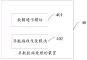
According to a third aspect of the present application, there is provided an apparatus for navigation data processing, comprising:
the data communication module is used for receiving the real-time traffic state information of the local route sent by the vehicle-mounted terminal; the route optimization module is used for adjusting the recommendation sequence of the candidate routes of the vehicle-mounted terminal according to the real-time traffic state information of the local routes; the data communication module is further used for sending the adjusted recommendation sequence of the candidate route to the vehicle-mounted terminal.
According to a fourth aspect of the present application, there is provided an apparatus for navigation data processing, comprising:
the data communication module is used for sending the real-time traffic state information of the local route to the server; the data communication module is further used for receiving a recommendation sequence of the candidate route fed back by the server, wherein the recommendation sequence of the candidate route is obtained after adjustment according to the real-time traffic state information of the local route; and the navigation route optimization module is used for determining the current optimal navigation route according to the recommendation sequence of the candidate route.
According to a fifth aspect of the present application, there is provided an electronic device comprising:
at least one processor; and a memory communicatively coupled to the at least one processor; wherein the memory stores instructions executable by the at least one processor to enable the at least one processor to perform the method of the first aspect.
According to a sixth aspect of the present application, there is provided an electronic device comprising:
at least one processor; and a memory communicatively coupled to the at least one processor; wherein the memory stores instructions executable by the at least one processor to enable the at least one processor to perform the method of the second aspect.
According to a seventh aspect of the present application, there is provided a non-transitory computer readable storage medium having stored thereon computer instructions for causing the computer to perform the method of any one of claims 1-18.
According to the technology of the application, the navigation route can be optimized in real time according to the real-time traffic state information of the local route.
It should be understood that the statements in this section do not necessarily identify key or critical features of the embodiments of the present application, nor do they limit the scope of the present application. Other features of the present application will become apparent from the following description.
Drawings
The drawings are included to provide a better understanding of the present solution and are not intended to limit the present application. Wherein:
FIG. 1 is a schematic diagram of a system architecture of a navigation system according to an embodiment of the present application;
FIG. 2 is a flow chart of a method of navigation data processing provided in a first embodiment of the present application;
FIG. 3 is a flow chart of a method of navigation data processing provided by a second embodiment of the present application;
FIG. 4 is a schematic view of a navigation data processing scenario provided in a second embodiment of the present application;
FIG. 5 is a schematic diagram of a navigation data processing apparatus according to a third embodiment of the present application;
FIG. 6 is a schematic diagram of a navigation data processing device according to a fifth embodiment of the present application;
FIG. 7 is a schematic diagram of an apparatus for processing navigation data according to a sixth embodiment of the present application;
FIG. 8 is a block diagram of an electronic device for implementing a method of navigation data processing of an embodiment of the present application;
fig. 9 is a block diagram of another electronic device for implementing a method of navigation data processing of an embodiment of the present application.
Detailed Description
The following description of the exemplary embodiments of the present application, taken in conjunction with the accompanying drawings, includes various details of the embodiments of the application for the understanding of the same, which are to be considered exemplary only. Accordingly, those of ordinary skill in the art will recognize that various changes and modifications of the embodiments described herein can be made without departing from the scope and spirit of the present application. Also, descriptions of well-known functions and constructions are omitted in the following description for clarity and conciseness.
The application provides a navigation data processing method, a navigation data processing device, a navigation data processing equipment and a storage medium, which are applied to the automatic driving and intelligent traffic technology in the field of data processing, so as to dynamically update a navigation route according to the real-time traffic state information of a local route at the current moment, and achieve the effect of optimizing the navigation route.
The embodiment of the application is applied to a navigation system, and fig. 1 shows a system architecture of the navigation system, and as shown in fig. 1, the navigation system includes a vehicle-mounted terminal (for example, an On Board Unit (OBU) shown in fig. 1) installed On a vehicle, a roadside device, a Multi-access Edge Computing (MEC) server, and a cloud server. As shown by the arrow labeled 1 in fig. 1, when a user first initiates a navigation route planning, a vehicle-mounted terminal or a map navigation APP (Application program) end requests a cloud server to specify a planned route of a start point and an end point. As shown by the arrow labeled 2 in fig. 1, the cloud server returns the candidate route set of the vehicle-mounted terminal or the navigation APP, and also returns global information of each candidate route, including time-consuming data characteristics of each candidate route on each road segment. As shown by the data flows indicated by arrows labeled 3 and 4 in fig. 1, in the driving process of the vehicle, the deployed transportation facilities can be networked based on the sensor and the fifth generation mobile communication (5G), the Road Side device (RSU for short) can interact with the OBU, and provide the OBU with the real-time traffic state information of the local route in the coverage area, such as the waiting time of a traffic signal lamp, the time for passing through the intersection by turning left, going straight, turning right, the real-time traffic time of the next Road section after passing through the intersection via different routes, and the like. Based on the real-time traffic status information of the local route and the global information of the candidate route, the OBU obtains the candidate route after the adjustment and rearrangement through the MEC server for the user to select, as shown by the arrows labeled 5 and 6 in fig. 1.
Fig. 2 is a flowchart of a navigation data processing method according to a first embodiment of the present application. In this embodiment, as shown in fig. 2, the method specifically includes the following steps:
and step S101, the vehicle-mounted terminal sends the real-time traffic state information of the local route to a server.
In this embodiment, the local route may include a route that is within a distance ahead of the vehicle-mounted terminal in the current driving direction, and may include an intersection and/or a road segment.
The real-time traffic state information of the local route is used for determining real-time consumption required by the local route under the current road condition.
For example, the real-time traffic status information of the local route may include real-time traffic information of the local route, and the vehicle-mounted terminal may estimate real-time consumed for passing through the local route under the current traffic condition according to the real-time traffic information of the local route.
Illustratively, the real-time traffic status information of the local route may also include real-time traffic time consumption of individual intersections and/or road segments in the local route.
In addition, the real-time traffic state information of the local route may be obtained by the vehicle-mounted terminal from a road side device, or a cloud server, or other devices, and this embodiment is not specifically limited here.
After the vehicle-mounted terminal acquires the real-time traffic state information of the local route, the real-time traffic state information of the local route is sent to the server, and the server completes reordering of the candidate route according to the real-time traffic state information of the local route.
And S102, the server receives the real-time traffic state information of the local route sent by the vehicle-mounted terminal.
In this embodiment, the server for adjusting the recommended order of the candidate route and other related data processing may be an MEC server, or other server based on edge calculation, or other device having data processing capability and capable of performing data communication with the vehicle-mounted terminal, and this embodiment is not limited in particular here.
And S103, the server adjusts the recommendation sequence of the candidate routes of the vehicle-mounted terminal according to the real-time traffic state information of the local routes.
After receiving the real-time traffic state information of the local route, the server can update the time consumption of each candidate route according to the real-time traffic state information of the local route, rearrange the recommendation sequence of each candidate route according to the updated time consumption, and dynamically optimize the recommendation sequence of the candidate route according to the real-time communication state information of the local route as the updated time consumption is shorter and the recommendation sequence of the candidate route is earlier.
And step S104, the server sends the adjusted recommendation sequence of the candidate routes to the vehicle-mounted terminal.
And step S105, the vehicle-mounted terminal receives the recommended sequence of the candidate routes fed back by the server.
The recommendation sequence of the candidate routes received by the vehicle-mounted terminal is obtained by adjusting the real-time traffic state information of the local routes.
And S106, determining the optimal navigation route by the vehicle-mounted terminal according to the recommendation sequence of the candidate route.
And the vehicle-mounted terminal selects the candidate route with the most front recommendation sequence as the optimal navigation route according to the recommendation sequence of the candidate routes.
According to the embodiment of the application, in the driving process of a vehicle, the real-time traffic state information of the local route in a distance ahead is acquired in real time, the real-time communication state information of the local route is sent to the server, the server optimizes and adjusts the recommendation sequence of each candidate route according to the real-time traffic state information of the local route, the vehicle-mounted terminal can determine the current optimal navigation route according to the adjusted recommendation sequence of the candidate route, the optimal navigation route can be dynamically optimized and adjusted according to the real-time traffic state of the local route ahead, and a better navigation route is provided for the vehicle.
FIG. 3 is a flow chart of a method of navigation data processing provided by a second embodiment of the present application; fig. 4 is a schematic view of a navigation data processing scenario provided in a second embodiment of the present application. On the basis of the first embodiment, in the present embodiment, when the vehicle enters the communication range of the roadside unit in the intersection, the vehicle-mounted terminal receives the real-time traffic state information of the local route transmitted by the roadside unit at the intersection. The real-time traffic status information of the local route comprises the following steps: real-time consuming to reach the intersection from the current position; waiting for time through traffic lights at the intersection; real-time consuming passing the first road segment after passing the intersection. As shown in fig. 3, the method comprises the following specific steps:
and S200, the vehicle-mounted terminal acquires an initial candidate route and a navigation route and carries out vehicle navigation according to the navigation route.
In the embodiment, for a user route starting and ending point (Origin-Destination, abbreviated as OD point) specified by a user, the vehicle-mounted terminal can send the OD point to the cloud server, the cloud server plans a route according to the OD point to obtain at least one candidate route, selects a preference factor according to a navigation route, and determines a recommendation sequence of the candidate route; and sending the candidate routes and the recommendation sequence to the vehicle-mounted terminal.
The navigation route selection preference factor may be a distance, a transit time, a road toll, whether to go at a high speed, and the like, and this embodiment is not specifically limited herein. In addition, the recommendation order of the candidate route may be determined according to one preference factor or a combination of multiple preference factors, and this embodiment is not limited in this embodiment.
In this embodiment, the candidate route planned for the first time is a set of planned routes with optimal prediction given according to information such as historical traffic flow and road conditions in the same period at the departure time (that is, at the time of route planning).
The data of the candidate route fed back to the vehicle-mounted terminal by the cloud server comprises estimated passing time of each road section on the candidate route. The estimated passing time of the road sections refers to the passing time of each road section estimated at the departure time.
If using taAnd expressing the departure time, expressing the acquired candidate route set by K, expressing any one candidate route by K, expressing the link set on the route K by L, expressing the link number in the route by L, and expressing the intersection number in the route by c. Time consuming first planning of an acquired route k Can be expressed as:

wherein f ist(l,ta) Is taThe time of day is estimated to be the time taken to traverse the link.
The vehicle-mounted terminal selects the candidate route with the most front recommended sequence as the navigation route, or the vehicle-mounted terminal displays a plurality of front ranked candidate routes and the recommended sequence thereof through the display device, so that the user can select and determine a final navigation route.
After the navigation route is determined, the vehicle-mounted terminal conducts navigation according to the navigation route, and the vehicle runs along the navigation route.
Step S201, in the running process of the vehicle, every time the vehicle enters the communication range of the road side unit in the intersection, the vehicle-mounted terminal receives the real-time traffic state information of the local route sent by the road side unit of the intersection.
The real-time traffic state information of the local route is determined according to the real-time road condition information of the local route at the current moment.
In this embodiment, in the driving process of the vehicle, when the vehicle terminal enters the communication range of the roadside unit in the intersection at the next intersection where the vehicle is about to arrive, the vehicle terminal may interact with the roadside unit in the intersection to receive the real-time traffic state information of the local route sent by the roadside unit.
In practical application, the passing time of the intersection is influenced by the real-time traffic light, the passing time of the road section may also be changed due to possible traffic events or vehicle accidents on the spot, and the road side unit can feed back the relevant information influencing the passing time of the intersection to the vehicle-mounted terminal.
In a possible implementation manner, the real-time traffic status information of the local route may include real-time traffic status information of the local route, and the vehicle-mounted terminal may estimate real-time consumption for passing through the local route under the current traffic status according to the real-time traffic status information of the local route.
Illustratively, the road side unit can acquire information such as traffic on roads, road conditions and road environments, and control information of traffic lights in intersections in real time, and can send the information to the vehicle-mounted terminal as real-time traffic state information of local routes.
In one possible embodiment, the real-time traffic status information of the local route may also include real-time traffic time consumption of each intersection and/or segment in the local route.
Illustratively, the road side unit can acquire information such as flow, road conditions and road environments on roads in the coverage area of the road side unit, control information of traffic lights in intersections and the like in real time, calculate real-time traffic time consumption of each road section and time for waiting for the traffic lights at the intersections according to the current road information, and send the calculation result to the vehicle-mounted terminal as real-time traffic state information of a local route.
Further, the real-time traffic status information of the local route comprises at least one of:
real-time consuming to reach the next intersection from the current position; waiting for time through traffic lights at the intersection; real-time traffic through the first road segment after the intersection is time consuming.
In practical application, under the influence of traffic flow, road conditions, road environments, traffic signal lamp control information and the like on roads, real-time road conditions of all road sections and intersections are constantly changed, so that the actual passing time of a vehicle reaching all the road sections and intersections is also changed, therefore, the real-time passing state information including the real-time passing time consumption of adjacent road sections and the waiting time consumption of the traffic signal lamps of the intersections is obtained in the driving process of the vehicle, the real-time remaining time of candidate routes is more accurately calculated in the subsequent steps based on the real-time passing state information of local routes, and the candidate routes are reordered based on the real-time remaining time, so that the real-time performance and the accuracy of recommending the candidate routes can be improved.
The waiting time of the traffic lights passing through the intersection comprises at least one of the following steps:
real-time consumption for waiting for a traffic signal lamp when a left turn passes through an intersection is required; real-time consumption for waiting for a traffic signal lamp when the vehicle passes through the intersection in a straight line; turning right through the intersection requires real-time consuming waiting for traffic lights.
Real-time transit through a first road segment after an intersection is time consuming, including at least one of:
real-time passage time consumption of a first road section after left-hand turn passes through the intersection; the real-time passing time of the first road section after the road junction is straightly passed is consumed; real-time passage of the first road segment after a right turn passes through the intersection is time consuming.
In practical application, a crossing may have multiple traffic directions, such as left turn, straight run, right turn, and the like, and the time required for waiting for the traffic light is different when the crossing is passed through in different directions at the same time, so that the real-time remaining time consumption of the candidate route can be further more accurately determined by respectively obtaining the real-time consumption required for waiting for the traffic light when the crossing is passed through in different traffic directions, and the recommendation sequence and the navigation route of the candidate route can be further optimized.
In this embodiment, the real-time traffic status information of the local route is used to determine real-time consumption required for passing through the local route under the current road condition, and this embodiment does not specifically limit which information the real-time traffic status information of the local route specifically includes.
After the vehicle-mounted terminal acquires the real-time traffic state information of the local route, the real-time traffic state information of the local route is sent to the server, and the server completes reordering of the candidate route according to the real-time traffic state information of the local route.
In the step, the real-time traffic state information of the local route sent by the road side unit is received in the communication range of the road side unit entering the intersection, so that the real-time traffic state information of the current local route can be accurately acquired in real time, and the real-time performance and the accuracy of the real-time traffic state information of the current local route are improved.
And step S202, the vehicle-mounted terminal sends the real-time traffic state information of the local route to a server.
In this embodiment, the server for adjusting the recommendation order of the candidate route and processing other related data may be an MEC server, which can improve data processing efficiency. In this embodiment, an MEC server is taken as an example for illustration, and the server may also be implemented by using other electronic devices, which is not specifically limited herein.
And step S203, the server receives the real-time traffic state information of the local route sent by the vehicle-mounted terminal.
After receiving the real-time traffic status information of the local route, the MEC server adjusts the recommended order of the candidate routes of the vehicle-mounted terminal according to the real-time traffic status information of the local route through the subsequent steps S203-S204.
And step S204, the server determines the real-time residual consumed time of the candidate route according to the real-time traffic state information of the local route.
Specifically, the method for determining the real-time consumption of the remaining route of the candidate route according to the real-time traffic state information of the local route comprises the following steps:
determining real-time consumption for passing through the local route according to the real-time traffic state information of the local route; updating the real-time remaining elapsed time for the candidate route including the local route based on the real-time elapsed time for traversing the local route.
In this embodiment, the MEC server may determine real-time elapsed time for passing through the local route according to the real-time traffic status information of the local route, and then update the real-time remaining elapsed time of the candidate route including the local route according to the real-time elapsed time of the local route and the estimated transit time of each road segment in the global route planning information of each candidate route.
And the updated real-time remaining consumed time of the candidate route is the sum of the real-time consumed time of the local route contained in the candidate route and the estimated passing time of each road section in the remaining route after the local route.
Optionally, the vehicle-mounted terminal may further obtain global route planning information of the candidate route; and sending the global route planning information of the candidate route to the MEC server. The MEC server receives global route planning information of the candidate routes sent by the vehicle-mounted terminal, adjusts the recommendation sequence of the candidate routes of the vehicle-mounted terminal according to the real-time traffic state information of the local routes and the global route planning information of the candidate routes, and can further optimize the recommendation sequence of the candidate routes.
Optionally, in the navigation process, when the vehicle-mounted terminal first sends the real-time traffic state information of the local route to the MEC server, the vehicle-mounted terminal may send the global route planning information of each candidate route to the MEC server together, and the MEC server receives and stores the global route planning information of each candidate route. In the subsequent process of the navigation, the MEC server directly uses the stored global route planning information of each candidate route. The global route planning information of the candidate routes comprises process characteristics of the planned routes, estimated passing time of each road section and other time-consuming data characteristics of each candidate route on each road section. The global route planning information may also include other information included in the raw data of the candidate route, which is not described herein again.
Optionally, the vehicle-mounted terminal may further send the global route planning information of each candidate route to the MEC server together each time the real-time traffic status information of the local route is sent to the MEC server.
Optionally, the MEC server may also serve as a cloud server for performing a first-time route, at this time, the MEC server may store the corresponding identification information of the vehicle-mounted terminal after obtaining the planned route according to the OD point of the current navigation, and in a subsequent navigation process, the MEC server may directly use the stored global route planning information of each candidate route.
In one possible embodiment, determining the real-time elapsed time for traversing the local route based on the real-time traffic status information of the local route comprises at least one of:
determining real-time consumption for turning left from the current position to pass through the next intersection according to the real-time traffic state information of the local route; determining real-time consumption for straight going through the next intersection from the current position according to the real-time traffic state information of the local route; and determining real-time consumption for turning right from the current position to pass the next intersection according to the real-time traffic state information of the local route.
In one possible embodiment, determining the real-time elapsed time for traversing the local route based on the real-time traffic status information of the local route comprises at least one of:
determining real-time consumption of turning left from the current position to pass through the next intersection and the first road section later according to the real-time traffic state information of the local route; determining real-time consumption of going straight through the next intersection and the first road section from the current position according to the real-time traffic state information of the local route; and determining real-time consumption for turning right from the current position to pass through the next intersection and the first road section after the next intersection according to the real-time traffic state information of the local route.
Taking the scenario shown in fig. 4 as an example, an implementation of determining the real-time remaining elapsed time of the candidate route according to the real-time traffic status information of the local route is exemplarily described. As shown in FIG. 4, during driving, when the vehicle is at tbWhen the time reaches the position P, the vehicle-mounted terminal enters the communication range of the RSU of the intersection (for example, a circle with a radius r as shown in fig. 4), and it is assumed that the current road segment is l0. For a candidate route requiring the next intersection in the route, the candidate route is divided into the following routes according to the passing mode (including at least one of the following: straight going, left turning and right turning) in the intersection: candidate route L going straight at the intersectionsA route candidate L for right turn at the intersectionrA candidate route L for left turn at the intersectionl. The vehicle-mounted terminal real-timely judges the traffic signal lamp S of the next intersection1The waiting time of the traffic signal lamp for straight going, left turning and right turning passing the intersection is obtained And the next road section l after going straight, turning left and turning right through the intersections、ll、lrReal-time traffic is time consuming. The crossing passing time is influenced by a real-time traffic signal lamp, and the passing time of a road section is changed due to possible traffic events or vehicle accidents on the spot. The RSU feeds back the real-time traffic time information to the vehicle-mounted terminal, the vehicle-mounted terminal sends the real-time traffic state information of the local route and the global route planning information of the initial candidate route to the MEC together, and the MEC is requested to reorder the candidate route. MEC passes status information in real time according to local routeDynamically updating the remaining real-time elapsed time of the candidate route k at the current time tbRecalculating the remaining real-time elapsed time for the candidate route as follows:

wherein lnextIndicates the next road segment after the crossing,/s、ll、lrRespectively straight going, left turning and right turning through the next road section behind the intersection, in order to reach the intersection from the current position point p in real time,
 waiting for the traffic lights passing through the intersection for straight going, left turning, and right turning, respectively, takes time ht(l,tb) For the section l at tbReal time elapsed time of time passing, ht(ll,tb)、ht(ls,tb)、ht(lr,tb) Are each at tbTime section ls、ll、lrThe real-time traffic of the user is time-consuming,
 represents a candidate route LlThe time spent on other road segments following the local route,
 represents a candidate route LsThe time spent on other road segments following the local route,
 represents a candidate route LrTime consuming to go to other road segments after the local route.
In this embodiment, calculating the real-time remaining time consumption of the candidate route, and merging the real-time road information of the local route into the global route planning information of the candidate route, includes: the actual flow, intersection and road environment of the road at the current moment, real-time passing time consumption of the traffic signal lamp for controlling different directions of the intersection and the like. The MEC corrects the real-time residual time consumption of the initial candidate route based on the static global route planning information of the candidate route and the real-time traffic state information of the dynamic local route, and rearranges the recommendation sequence of the candidate route, so that the MEC can guide the user to optimize the navigation route in real time.
And S205, the server sorts the candidate routes according to the real-time residual consumed time to obtain the recommendation sequence of the candidate routes.
After the real-time residual consumed time of each candidate route is obtained, the candidate routes are ranked according to the sequence of the real-time residual consumed time of each candidate route from short to long, and the recommendation sequence of the candidate routes is obtained.
The candidate routes with shorter time consumption are left in real time, and the recommendation sequence of the candidate routes is earlier, so that the recommendation sequence of the candidate routes can be dynamically optimized according to the real-time communication state information of the local routes.
And step S206, the server sends the adjusted recommendation sequence of the candidate routes to the vehicle-mounted terminal.
After the candidate routes are sequenced to obtain the recommendation sequence of the candidate routes, the MEC server sends the adjusted recommendation sequence of the candidate routes to the vehicle-mounted terminal.
Optionally, the MEC server may reorder the candidate routes according to the recommended order, and then send the reordered candidate routes to the vehicle-mounted terminal; or, the MEC server may directly generate the recommendation order of each candidate route to the vehicle-mounted terminal; or, the MEC server may send the recommendation sequence and the real-time remaining time of each candidate route to the vehicle-mounted terminal, which is not described herein again.
And step S207, the vehicle-mounted terminal receives the recommended sequence of the candidate routes fed back by the server.
And the recommendation sequence of the candidate route is obtained after adjustment according to the real-time traffic state information of the local route.
And S208, determining the optimal navigation route by the vehicle-mounted terminal according to the recommendation sequence of the candidate route.
After the recommendation order of the candidate routes is obtained, the vehicle-mounted terminal can select the candidate route with the most front recommendation order as the optimal navigation route.
Alternatively, after determining the optimal navigation route, the vehicle-mounted terminal may directly switch the current navigation route to the optimal navigation route.
Optionally, after determining the optimal navigation route, the vehicle-mounted terminal may send a first prompt message for switching the optimal navigation to the user, and after the user confirms the switching, the current navigation route is switched to the optimal navigation route.
Further, the first prompt information for switching the optimal navigation may further include information such as a real-time remaining duration of the optimal navigation route, a duration that the optimal navigation can be switched to may be shortened, and the like, so that the user may refer to and determine whether to switch the navigation route.
Optionally, after the recommendation sequence of the candidate route is obtained, the vehicle-mounted terminal may further determine the candidate route with the recommendation sequence ranked in the first few digits, and send second prompt information to the user, where the second prompt information may include the recommendation sequence and the real-time remaining time of the candidate route with the recommendation sequence ranked in the first few digits, so that the user can refer to whether to switch the current navigation route to one of the candidate routes, and update the navigation route according to the selection result of the user.
In this embodiment, only a navigation data processing process to reach an intersection is taken as an example for explanation, in the process that a vehicle runs from a starting point to a terminal point, when the vehicle runs to a P position of one intersection, namely, enters a communication range of a road side unit in the intersection, the method provided by the embodiment is used for optimizing a navigation route once, an adjusted route is obtained, the vehicle runs to the position of the next intersection according to the finally determined navigation route, the method provided by the embodiment is continuously used for optimizing the navigation route, the adjusted route is obtained, the vehicle runs to the P ″ position of the next intersection according to the finally determined navigation route, and so on, the continuous real-time update of the user navigation route is realized until the terminal point is reached.
In the embodiment of the application, the traffic signal lamp does not influence the first planned route, but dynamically interferes the current running route in the running process, and adjusts the candidate route scheme. When the vehicle-mounted terminal is about to arrive at the next intersection, the vehicle-mounted terminal can acquire the waiting time and the passing time of turning left, going straight and turning right at the intersection in real time and feed back the waiting time and the passing time to the MEC server, the MEC server intervenes and reorders the subsequent routes according to the real-time consumed time of passing through the intersection in different directions controlled by the traffic signal lamps, issues and returns the reordering results to the vehicle-mounted terminal, and the intersection traffic signal lamps influence the current route planning of the user in real time.
In addition, the candidate route which is firstly planned and acquired when the user goes out is a predicted optimal result which is given according to historical synchronous traffic flow, road condition and other information at the departure time. In the driving process, when the real passing state of a road section changes, the roadside device feeds back the information of the real local route passing state change to the vehicle-mounted terminal, the vehicle-mounted terminal sends the local route passing state change to the MEC server, the MEC server dynamically calculates and adjusts the recommended sequence of the candidate route by combining the global route planning information of the initial candidate route and the real information of the local route passing state change, returns the optimized candidate route to the vehicle-mounted terminal, and guides a user to obtain a real-time more optimal route; the method can influence the route planning scheme in real time by the real-time passing time of the red and green lights of the road in the planned route and the factors influencing the road traffic, such as real-time road conditions of the road, sudden traffic accidents, temporary traffic flow control and the like, adjust the route of the user in time, and provide the real-time and personalized global optimal route for the user by combining the travel habit data of the user.
In another implementation manner of this embodiment, when the vehicle travels on a road segment, the vehicle-mounted terminal may further receive real-time traffic status information of the current road segment sent by the road-side device on the current road segment, and send the real-time traffic status information to the MEC server; if the MEC server determines that abnormal events (such as road control, traffic accidents and the like) exist in the current road section according to the real-time traffic state information of the current road section, readjusting the recommended ordering of the candidate routes, and feeding back the reordered candidate routes to the vehicle-mounted terminal; and the vehicle-mounted terminal determines an optimal navigation route according to the reordered candidate route.
Optionally, the real-time traffic status information of the current road section may further include an estimated traffic time of the current road section. The time that the road cannot normally pass due to different abnormal events may be different, and the passing time can be estimated to reorder the candidate routes.
Optionally, if it is determined that an abnormal event exists in the current road segment, the candidate route may be re-planned to obtain a better navigation route.
In the embodiment of the application, when a vehicle enters a communication range of a road side unit in an intersection in the driving process, road side equipment of the intersection feeds real-time traffic state information of a local route back to a vehicle-mounted terminal, the vehicle-mounted terminal sends the traffic state change of the local route to an MEC (media integrated circuit) server, the MEC server dynamically calculates and adjusts a recommended sequence of the candidate route according to the real-time traffic state information of the local route and global route planning information of the candidate route, the optimized candidate route is returned to the vehicle-mounted terminal, and a user is guided to obtain a real-time more optimal route; the method can comprehensively sequence the candidate routes according to the real-time passing time of the intersection traffic signal lamp, the real-time flow of the adjacent road, the road condition, the emergency and other factors influencing the road traffic, and adjust the recommended sequence of the candidate routes in time, thereby giving real-time and personalized global optimal navigation routes to users.
Fig. 5 is a schematic diagram of a navigation data processing apparatus according to a third embodiment of the present application. The navigation data processing device provided by the embodiment of the application can execute the processing flow provided by the navigation data processing method embodiment, and can be applied to a server, such as an MEC server. As shown in fig. 5, the apparatus 30 for navigation data processing includes: a data communication module 301 and a route optimization module 302.
Specifically, the data communication module 301 is configured to receive real-time traffic status information of the local route sent by the vehicle-mounted terminal.
The route optimization module 302 is configured to adjust a recommendation sequence of candidate routes of the vehicle-mounted terminal according to the real-time traffic state information of the local route.
The data communication module 301 is further configured to send the adjusted recommendation order of the candidate routes to the vehicle-mounted terminal.
The apparatus provided in this embodiment of the present application may be specifically configured to execute the method flow executed by the server in the first embodiment, and specific functions are not described herein again.
According to the embodiment of the application, in the driving process of a vehicle, the real-time traffic state information of the local route in a distance ahead is acquired in real time, the real-time communication state information of the local route is sent to the server, the server optimizes and adjusts the recommendation sequence of each candidate route according to the real-time traffic state information of the local route, the vehicle-mounted terminal can determine the current optimal navigation route according to the adjusted recommendation sequence of the candidate route, the optimal navigation route can be dynamically optimized and adjusted according to the real-time traffic state of the local route ahead, and a better navigation route is provided for the vehicle.
On the basis of the third embodiment, in the fourth embodiment, the route optimization module is further configured to:
determining real-time remaining time consumption of the candidate route according to the real-time traffic state information of the local route; and sequencing the candidate routes according to the real-time residual time consumption to obtain the recommendation sequence of the candidate routes.
In one possible embodiment, the route optimization module is further configured to:
determining real-time consumption for passing through the local route according to the real-time traffic state information of the local route; updating the real-time remaining elapsed time for the candidate route including the local route based on the real-time elapsed time for traversing the local route.
In one possible embodiment, the route optimization module is further configured to:
determining real-time consumption for turning left from the current position to pass through the next intersection according to the real-time traffic state information of the local route; determining real-time consumption for straight going through the next intersection from the current position according to the real-time traffic state information of the local route; and determining real-time consumption for turning right from the current position to pass the next intersection according to the real-time traffic state information of the local route.
In one possible embodiment, the route optimization module is further configured to:
determining real-time consumption of turning left from the current position to pass through the next intersection and the first road section later according to the real-time traffic state information of the local route; determining real-time consumption of going straight through the next intersection and the first road section from the current position according to the real-time traffic state information of the local route; and determining real-time consumption for turning right from the current position to pass through the next intersection and the first road section after the next intersection according to the real-time traffic state information of the local route.
In one possible embodiment, the data communication module is further configured to:
and receiving global route planning information of the candidate route sent by the vehicle-mounted terminal.
In one possible embodiment, the route optimization module is further configured to:
and adjusting the recommendation sequence of the candidate routes of the vehicle-mounted terminal according to the real-time traffic state information of the local routes and the global route planning information of the candidate routes.
In one possible embodiment, the real-time traffic status information of the local route comprises at least one of:
real-time consuming to reach the next intersection from the current position; waiting for time through traffic lights at the intersection; real-time traffic through the first road segment after the intersection is time consuming.
In one possible embodiment, the traffic light waiting through the intersection is time consuming, including at least one of:
real-time consumption for waiting for a traffic signal lamp when a left turn passes through an intersection is required; real-time consumption for waiting for a traffic signal lamp when the vehicle passes through the intersection in a straight line; turning right through the intersection requires real-time consuming waiting for traffic lights.
In one possible embodiment, the real-time passing through the first road segment after the intersection is time consuming, including at least one of:
real-time passage time consumption of a first road section after left-hand turn passes through the intersection; the real-time passing time of the first road section after the road junction is straightly passed is consumed; real-time passage of the first road segment after a right turn passes through the intersection is time consuming.
The apparatus provided in this embodiment of the present application may be specifically configured to execute the method flow executed by the server in the second embodiment, and specific functions are not described herein again.
In the embodiment of the application, when a vehicle enters a communication range of a road side unit in an intersection in the driving process, road side equipment of the intersection feeds real-time traffic state information of a local route back to a vehicle-mounted terminal, the vehicle-mounted terminal sends the traffic state change of the local route to an MEC (media integrated circuit) server, the MEC server dynamically calculates and adjusts a recommended sequence of the candidate route according to the real-time traffic state information of the local route and global route planning information of the candidate route, the optimized candidate route is returned to the vehicle-mounted terminal, and a user is guided to obtain a real-time more optimal route; the method can comprehensively sequence the candidate routes according to the real-time passing time of the intersection traffic signal lamp, the real-time flow of the adjacent road, the road condition, the emergency and other factors influencing the road traffic, and adjust the recommended sequence of the candidate routes in time, thereby giving real-time and personalized global optimal navigation routes to users.
Fig. 6 is a schematic diagram of a navigation data processing device according to a fifth embodiment of the present application. The navigation data processing device provided by the embodiment of the application can execute the processing flow provided by the navigation data processing method embodiment, and can be applied to a vehicle-mounted terminal. As shown in fig. 6, the navigation data processing apparatus 40 includes: a data communication module 401 and a navigation route optimization module 402.
Specifically, the data communication module 401 is configured to send real-time traffic status information of the local route to the server.
The data communication module 401 is further configured to receive a recommendation sequence of the candidate route fed back by the server, where the recommendation sequence of the candidate route is obtained by adjusting according to the real-time traffic state information of the local route.
And a navigation route optimization module 402, configured to determine a current optimal navigation route according to the recommended order of the candidate routes.
The apparatus provided in this embodiment of the present application may be specifically configured to execute the method performed by the vehicle-mounted terminal in the first embodiment, and specific functions are not described herein again.
According to the embodiment of the application, in the driving process of a vehicle, the real-time traffic state information of the local route in a distance ahead is acquired in real time, the real-time communication state information of the local route is sent to the server, the server optimizes and adjusts the recommendation sequence of each candidate route according to the real-time traffic state information of the local route, the vehicle-mounted terminal can determine the current optimal navigation route according to the adjusted recommendation sequence of the candidate route, the optimal navigation route can be dynamically optimized and adjusted according to the real-time traffic state of the local route ahead, and a better navigation route is provided for the vehicle.
Fig. 7 is a schematic diagram of a navigation data processing apparatus according to a sixth embodiment of the present application. On the basis of the fifth embodiment, in the present embodiment, as shown in fig. 7, the apparatus 40 for processing navigation data further includes a data obtaining module 403, configured to obtain global route planning information of the candidate route. The data communication module is further configured to send global routing information for the candidate route to the server.
In one possible embodiment, the data communication module is further configured to:
and in the running process of the vehicle, whenever the vehicle enters the communication range of the road side unit in the intersection, receiving the real-time traffic state information of the local route sent by the road side unit of the intersection.
In one possible implementation, the real-time traffic status information of the local route is determined according to the real-time traffic status information of the local route at the current time.
In one possible embodiment, the real-time traffic status information of the local route comprises at least one of:
real-time consuming to reach the next intersection from the current position; waiting for time through traffic lights at the intersection; real-time traffic through the first road segment after the intersection is time consuming.
In one possible embodiment, the traffic light waiting through the intersection is time consuming, including at least one of:
real-time consumption for waiting for a traffic signal lamp when a left turn passes through an intersection is required; real-time consumption for waiting for a traffic signal lamp when the vehicle passes through the intersection in a straight line; turning right through the intersection requires real-time consuming waiting for traffic lights.
In one possible embodiment, the real-time passing through the first road segment after the intersection is time consuming, and comprises at least one of the following:
real-time passage time consumption of a first road section after left-hand turn passes through the intersection; the real-time passing time of the first road section after the road junction is straightly passed is consumed; real-time passage of the first road segment after a right turn passes through the intersection is time consuming.
In one possible embodiment, the navigation route optimization module is further configured to:
and switching the current navigation route to the optimal navigation route.
The apparatus provided in this embodiment of the present application may be specifically configured to execute the method flow executed by the vehicle-mounted terminal in the second embodiment, and specific functions are not described herein again.
In the embodiment of the application, when a vehicle enters a communication range of a road side unit in an intersection in the driving process, road side equipment of the intersection feeds real-time traffic state information of a local route back to a vehicle-mounted terminal, the vehicle-mounted terminal sends the traffic state change of the local route to an MEC (media integrated circuit) server, the MEC server dynamically calculates and adjusts a recommended sequence of the candidate route according to the real-time traffic state information of the local route and global route planning information of the candidate route, the optimized candidate route is returned to the vehicle-mounted terminal, and a user is guided to obtain a real-time more optimal route; the method can comprehensively sequence the candidate routes according to the real-time passing time of the intersection traffic signal lamp, the real-time flow of the adjacent road, the road condition, the emergency and other factors influencing the road traffic, and adjust the recommended sequence of the candidate routes in time, thereby giving real-time and personalized global optimal navigation routes to users.
According to an embodiment of the present application, an electronic device and a readable storage medium are also provided. As shown in fig. 8, is a block diagram of an electronic device of a method of navigation data processing according to an embodiment of the present application. As shown in fig. 8, the electronic apparatus includes: at least one processor Y01; and a memory Y02 communicatively connected to the at least one processor; the memory Y02 stores instructions executable by the at least one processor Y01, the instructions being executable by the at least one processor Y01 to enable the at least one processor Y01 to perform the process performed by the server in any of the above method embodiments.
Electronic devices are intended to represent various forms of digital computers, such as laptops, desktops, workstations, personal digital assistants, servers, blade servers, mainframes, and other appropriate computers. The electronic device may also represent various forms of mobile devices, such as personal digital processing, cellular phones, smart phones, wearable devices, and other similar computing devices. The components shown herein, their connections and relationships, and their functions, are meant to be examples only, and are not meant to limit implementations of the present application that are described and/or claimed herein.
As shown in fig. 8, the electronic apparatus includes: one or more processors Y01, a memory Y02, and interfaces for connecting the various components, including a high speed interface and a low speed interface. The various components are interconnected using different buses and may be mounted on a common motherboard or in other manners as desired. The processor may process instructions for execution within the electronic device, including instructions stored in or on the memory to display graphical information of a GUI on an external input/output apparatus (such as a display device coupled to the interface). In other embodiments, multiple processors and/or multiple buses may be used, along with multiple memories, as desired. Also, multiple electronic devices may be connected, with each device providing portions of the necessary operations (e.g., as a server array, a group of blade servers, or a multi-processor system). In fig. 8, one processor Y01 is taken as an example.
Memory Y02 is a non-transitory computer readable storage medium as provided herein. The memory stores instructions executable by the at least one processor to cause the at least one processor to perform the method of navigation data processing provided herein. The non-transitory computer-readable storage medium of the present application stores computer instructions for causing a computer to perform the method of navigation data processing provided herein.
The memory Y02 is a non-transitory computer readable storage medium that can be used to store non-transitory software programs, non-transitory computer executable programs, and modules, such as program instructions/modules corresponding to the method of navigation data processing in the embodiments of the present application (for example, the data communication module 301 and the route optimization module 302 shown in fig. 5). The processor Y01 executes various functional applications of the server and data processing, i.e., a method of navigation data processing performed by the server side in the above-described method embodiments, by executing non-transitory software programs, instructions, and modules stored in the memory Y02.
The memory Y02 may include a storage program area and a storage data area, wherein the storage program area may store an operating system, an application program required for at least one function; the storage data area may store data created according to use of the electronic device processed by the navigation data, and the like. Additionally, the memory Y02 may include high speed random access memory, and may also include non-transitory memory, such as at least one magnetic disk storage device, flash memory device, or other non-transitory solid state storage device. In some embodiments, memory Y02 may optionally include memory located remotely from processor Y01, which may be connected to the navigation data processing electronics via a network. Examples of such networks include, but are not limited to, the internet, intranets, local area networks, mobile communication networks, and combinations thereof.
The electronic device of the method of navigation data processing may further include: an input device Y03 and an output device Y04. The processor Y01, the memory Y02, the input device Y03, and the output device Y04 may be connected by a bus or other means, and the bus connection is exemplified in fig. 8.
The input device Y03 may receive input numeric or character information and generate key signal inputs related to user settings and function control of the electronic apparatus for navigation data processing, such as a touch screen, keypad, mouse, track pad, touch pad, pointer stick, one or more mouse buttons, track ball, joystick or other input device. The output device Y04 may include a display device, an auxiliary lighting device (e.g., LED), a tactile feedback device (e.g., vibration motor), and the like. The display device may include, but is not limited to, a Liquid Crystal Display (LCD), a Light Emitting Diode (LED) display, and a plasma display. In some implementations, the display device can be a touch screen.
Various implementations of the systems and techniques described here can be realized in digital electronic circuitry, integrated circuitry, application specific ASICs (application specific integrated circuits), computer hardware, firmware, software, and/or combinations thereof. These various embodiments may include: implemented in one or more computer programs that are executable and/or interpretable on a programmable system including at least one programmable processor, which may be special or general purpose, receiving data and instructions from, and transmitting data and instructions to, a storage system, at least one input device, and at least one output device.
These computer programs (also known as programs, software applications, or code) include machine instructions for a programmable processor, and may be implemented using high-level procedural and/or object-oriented programming languages, and/or assembly/machine languages. As used herein, the terms "machine-readable medium" and "computer-readable medium" refer to any computer program product, apparatus, and/or device (e.g., magnetic discs, optical disks, memory, Programmable Logic Devices (PLDs)) used to provide machine instructions and/or data to a programmable processor, including a machine-readable medium that receives machine instructions as a machine-readable signal. The term "machine-readable signal" refers to any signal used to provide machine instructions and/or data to a programmable processor.
To provide for interaction with a user, the systems and techniques described here can be implemented on a computer having: a display device (e.g., a CRT (cathode ray tube) or LCD (liquid crystal display) monitor) for displaying information to a user; and a keyboard and a pointing device (e.g., a mouse or a trackball) by which a user can provide input to the computer. Other kinds of devices may also be used to provide for interaction with a user; for example, feedback provided to the user can be any form of sensory feedback (e.g., visual feedback, auditory feedback, or tactile feedback); and input from the user may be received in any form, including acoustic, speech, or tactile input.
The systems and techniques described here can be implemented in a computing system that includes a back-end component (e.g., as a data server), or that includes a middleware component (e.g., an application server), or that includes a front-end component (e.g., a user computer having a graphical user interface or a web browser through which a user can interact with an implementation of the systems and techniques described here), or any combination of such back-end, middleware, or front-end components. The components of the system can be interconnected by any form or medium of digital data communication (e.g., a communication network). Examples of communication networks include: local Area Networks (LANs), Wide Area Networks (WANs), and the Internet.
The computer system may include clients and servers. A client and server are generally remote from each other and typically interact through a communication network. The relationship of client and server arises by virtue of computer programs running on the respective computers and having a client-server relationship to each other.
According to an embodiment of the present application, an electronic device and a readable storage medium are also provided. As shown in fig. 9, it is a block diagram of an electronic device of a method of navigation data processing according to an embodiment of the present application. As shown in fig. 9, the electronic apparatus includes: at least one processor X01; and a memory X02 communicatively connected to the at least one processor; the memory X02 stores instructions executable by the at least one processor X01, and the instructions are executed by the at least one processor X01, so that the at least one processor X01 can execute the processing flow executed by the in-vehicle terminal in any of the above method embodiments. The electronic device of the method of navigation data processing may further include: an input device X03 and an output device X04. The processor X01, the memory X02, the input device X03, and the output device X04 may be connected by a bus or other means, and are exemplified by being connected by a bus in fig. 9.
In this embodiment, the electronic device and the readable storage medium are similar to the electronic device and the readable storage medium in the embodiment corresponding to fig. 8, and details of this embodiment are not repeated here.
It should be understood that various forms of the flows shown above may be used, with steps reordered, added, or deleted. For example, the steps described in the present application may be executed in parallel, sequentially, or in different orders, and the present invention is not limited thereto as long as the desired results of the technical solutions disclosed in the present application can be achieved.
The above-described embodiments should not be construed as limiting the scope of the present application. It should be understood by those skilled in the art that various modifications, combinations, sub-combinations and substitutions may be made in accordance with design requirements and other factors. Any modification, equivalent replacement, and improvement made within the spirit and principle of the present application shall be included in the protection scope of the present application.
Claims (23)
1. A method of navigation data processing, comprising:
receiving real-time traffic state information of a local route sent by a vehicle-mounted terminal;
according to the real-time traffic state information of the local route, adjusting the recommendation sequence of the candidate route of the vehicle-mounted terminal;
and sending the adjusted recommendation sequence of the candidate routes to the vehicle-mounted terminal.
2. The method according to claim 1, wherein the adjusting the recommended sequence of the candidate routes of the vehicle-mounted terminal according to the real-time traffic state information of the local routes comprises:
determining real-time remaining time consumption of the candidate route according to the real-time traffic state information of the local route;
and sequencing the candidate routes according to the real-time residual consumed time to obtain the recommendation sequence of the candidate routes.
3. The method of claim 2, wherein the determining a real-time elapsed time for the remaining route of the candidate route from the real-time traffic status information for the local route comprises:
determining real-time consumption for passing through the local route according to the real-time traffic state information of the local route;
updating the real-time remaining elapsed time for the candidate route including the local route based on the real-time elapsed time for traversing the local route.
4. The method of claim 3, wherein the determining a real-time elapsed time for traversing the local route from the real-time traffic status information of the local route comprises at least one of:
determining real-time consumption for turning left from the current position to pass through the next intersection according to the real-time traffic state information of the local route;
determining real-time consumption for straight going through the next intersection from the current position according to the real-time traffic state information of the local route;
and determining real-time consumption for turning right from the current position to pass the next intersection according to the real-time traffic state information of the local route.
5. The method of claim 3, wherein the determining a real-time elapsed time for traversing the local route from the real-time traffic status information of the local route comprises at least one of:
determining real-time consumption of turning left from the current position to pass through the next intersection and the first road section later according to the real-time traffic state information of the local route;
determining real-time consumption of going straight through the next intersection and the first road section from the current position according to the real-time traffic state information of the local route;
and determining real-time consumption for turning right from the current position to pass through the next intersection and the first road section after the next intersection according to the real-time traffic state information of the local route.
6. The method according to claim 1, wherein before adjusting the recommended order of the candidate routes of the vehicle-mounted terminal according to the real-time traffic status information of the local route, the method further comprises:
and receiving global route planning information of the candidate route sent by the vehicle-mounted terminal.
7. The method of claim 6, wherein the adjusting the recommended sequence of the candidate routes of the vehicle-mounted terminal according to the real-time traffic state information of the local routes comprises:
and adjusting the recommendation sequence of the candidate route of the vehicle-mounted terminal according to the real-time traffic state information of the local route and the global route planning information of the candidate route.
8. The method of any of claims 1-7, wherein the real-time traffic status information of the local route comprises at least one of:
real-time consuming to reach the next intersection from the current position;
waiting for time consumption by the traffic lights at the intersection;
real-time traffic through the first road segment after the intersection is time consuming.
9. The method of claim 8, wherein the traffic light wait through the intersection is time consuming, comprising at least one of:
real-time consumption for waiting for a traffic signal lamp when turning left to pass through the intersection is required;
real-time consumption for waiting for a traffic signal lamp when the vehicle passes through the intersection straight;
and the right turn passes through the intersection and needs to wait for the real-time consumption of the traffic signal lamp.
10. The method of claim 8, wherein the real-time passage through the first road segment after the intersection is time consuming, comprising at least one of:
real-time passage time consumption of a first road section after left-hand turn through the intersection;
the real-time passing time of the first road section after the road junction is straightly passed through is consumed;
real-time passage of the first road segment after a right turn through the intersection is time consuming.
11. A method of navigation data processing, comprising:
sending the real-time traffic state information of the local route to a server;
receiving a recommended sequence of the candidate route fed back by the server, wherein the recommended sequence of the candidate route is obtained after adjustment according to the real-time traffic state information of the local route;
and determining the current optimal navigation route according to the recommendation sequence of the candidate route.
12. The method of claim 11, further comprising:
acquiring global route planning information of the candidate route;
and sending the global route planning information of the candidate route to a server.
13. The method of claim 11 or 12, wherein before sending the real-time traffic status information of the local route to the server, further comprising:
and in the running process of the vehicle, whenever the vehicle enters the communication range of the road side unit in the intersection, receiving the real-time traffic state information of the local route sent by the road side unit of the intersection.
14. The method of claim 13, wherein the real-time traffic status information of the local route is determined according to the real-time traffic status information of the local route at the current time.
15. The method of claim 13, wherein the real-time traffic status information of the local route comprises at least one of:
real-time consuming to reach the next intersection from the current position;
waiting for time consumption by the traffic lights at the intersection;
real-time traffic through the first road segment after the intersection is time consuming.
16. The method of claim 15, wherein the traffic light wait through the intersection is time consuming, comprising at least one of:
real-time consumption for waiting for a traffic signal lamp when turning left to pass through the intersection is required;
real-time consumption for waiting for a traffic signal lamp when the vehicle passes through the intersection straight;
and the right turn passes through the intersection and needs to wait for the real-time consumption of the traffic signal lamp.
17. The method of claim 15, wherein the real-time passage through the first road segment after the intersection is time consuming, comprising at least one of:
real-time passage time consumption of a first road section after left-hand turn through the intersection;
the real-time passing time of the first road section after the road junction is straightly passed through is consumed;
real-time passage of the first road segment after a right turn through the intersection is time consuming.
18. The method of claim 11, wherein after determining the optimal navigation route according to the recommended order of the candidate routes, further comprising:
and switching the current navigation route to the optimal navigation route.
19. An apparatus for navigation data processing, comprising:
the data communication module is used for receiving the real-time traffic state information of the local route sent by the vehicle-mounted terminal;
the route optimization module is used for adjusting the recommendation sequence of the candidate routes of the vehicle-mounted terminal according to the real-time traffic state information of the local routes;
the data communication module is further used for sending the adjusted recommendation sequence of the candidate route to the vehicle-mounted terminal.
20. An apparatus for navigation data processing, comprising:
the data communication module is used for sending the real-time traffic state information of the local route to the server;
the data communication module is further used for receiving a recommendation sequence of the candidate route fed back by the server, wherein the recommendation sequence of the candidate route is obtained after adjustment according to the real-time traffic state information of the local route;
and the navigation route optimization module is used for determining the current optimal navigation route according to the recommendation sequence of the candidate route.
21. An electronic device, comprising:
at least one processor; and
a memory communicatively coupled to the at least one processor; wherein the content of the first and second substances,
the memory stores instructions executable by the at least one processor to enable the at least one processor to perform the method of any one of claims 1-10.
22. An electronic device, comprising:
at least one processor; and
a memory communicatively coupled to the at least one processor; wherein the content of the first and second substances,
the memory stores instructions executable by the at least one processor to enable the at least one processor to perform the method of any one of claims 11-18.
23. A non-transitory computer readable storage medium having stored thereon computer instructions for causing the computer to perform the method of any one of claims 1-18.
Priority Applications (5)
| Application Number | Priority Date | Filing Date | Title |
|---|---|---|---|
| CN202010749202.1A CN111896018A (en) | 2020-07-30 | 2020-07-30 | Navigation data processing method, device, equipment and storage medium |
| KR1020210012173A KR102569252B1 (en) | 2020-07-30 | 2021-01-28 | Method and apparatus for processing navigation data, device and storage medium |
| JP2021019419A JP7256833B2 (en) | 2020-07-30 | 2021-02-10 | Navigation data processing method, apparatus, equipment and storage medium |
| US17/207,286 US20210215494A1 (en) | 2020-07-30 | 2021-03-19 | Method and apparatus for processing navigation data, device and storage medium |
| EP21167109.4A EP3842761A3 (en) | 2020-07-30 | 2021-04-07 | Method and apparatus for processing navigation data, device and storage medium |
Applications Claiming Priority (1)
| Application Number | Priority Date | Filing Date | Title |
|---|---|---|---|
| CN202010749202.1A CN111896018A (en) | 2020-07-30 | 2020-07-30 | Navigation data processing method, device, equipment and storage medium |
Publications (1)
| Publication Number | Publication Date |
|---|---|
| CN111896018A true CN111896018A (en) | 2020-11-06 |
Family
ID=73182567
Family Applications (1)
| Application Number | Title | Priority Date | Filing Date |
|---|---|---|---|
| CN202010749202.1A Pending CN111896018A (en) | 2020-07-30 | 2020-07-30 | Navigation data processing method, device, equipment and storage medium |
Country Status (5)
| Country | Link |
|---|---|
| US (1) | US20210215494A1 (en) |
| EP (1) | EP3842761A3 (en) |
| JP (1) | JP7256833B2 (en) |
| KR (1) | KR102569252B1 (en) |
| CN (1) | CN111896018A (en) |
Cited By (6)
| Publication number | Priority date | Publication date | Assignee | Title |
|---|---|---|---|---|
| CN113487903A (en) * | 2021-07-04 | 2021-10-08 | 葛纪侠 | Internet of vehicles intelligent navigation obstacle crossing method and device and electronic equipment |
| CN113722595A (en) * | 2021-09-01 | 2021-11-30 | 北京百度网讯科技有限公司 | Information recommendation method and device, electronic equipment and medium |
| CN113916233A (en) * | 2021-10-20 | 2022-01-11 | 上海擎朗智能科技有限公司 | Navigation route determining method, device, equipment and storage medium |
| CN114509078A (en) * | 2020-11-16 | 2022-05-17 | 中国联合网络通信集团有限公司 | Navigation route recommendation method and server |
| WO2022199384A1 (en) * | 2021-03-22 | 2022-09-29 | 华为技术有限公司 | Map message sending method and apparatus |
| WO2022199393A1 (en) * | 2021-03-23 | 2022-09-29 | 华为技术有限公司 | Navigation method, apparatus, map and system |
Families Citing this family (5)
| Publication number | Priority date | Publication date | Assignee | Title |
|---|---|---|---|---|
| US20200124435A1 (en) * | 2018-10-17 | 2020-04-23 | Toyota Motor North America, Inc. | Distributed route determination system |
| CN114584584A (en) * | 2022-02-28 | 2022-06-03 | 福思(杭州)智能科技有限公司 | System and method for processing vehicle driving data and storage medium |
| WO2023184146A1 (en) * | 2022-03-29 | 2023-10-05 | 京东方科技集团股份有限公司 | Navigation method and system, and cloud server, mobile terminal, electronic device and medium |
| CN115830843B (en) * | 2022-09-21 | 2023-06-30 | 慧之安信息技术股份有限公司 | Private car networking method based on edge calculation |
| CN117894201A (en) * | 2024-03-11 | 2024-04-16 | 湘江实验室 | Road traffic guiding method and device based on global traffic information and related equipment |
Citations (6)
| Publication number | Priority date | Publication date | Assignee | Title |
|---|---|---|---|---|
| CN105096622A (en) * | 2015-08-11 | 2015-11-25 | 吉林大学 | Dynamic route guidance method based on vehicle-road communication |
| CN108180919A (en) * | 2017-12-12 | 2018-06-19 | 沈阳美行科技有限公司 | A kind of optimization method and device of programme path |
| CN108986509A (en) * | 2018-08-13 | 2018-12-11 | 北方工业大学 | Urban area path real-time planning method based on vehicle-road cooperation |
| CN109000676A (en) * | 2018-06-22 | 2018-12-14 | 东华大学 | The paths planning method of predictive information is combined under a kind of VANET environment |
| CN110595493A (en) * | 2019-09-25 | 2019-12-20 | 北京蓦然认知科技有限公司 | Real-time dynamic path planning method and device |
| US20200025584A1 (en) * | 2018-07-23 | 2020-01-23 | Here Global B.V. | Method, apparatus, and computer program product for determining lane level traffic information |
Family Cites Families (11)
| Publication number | Priority date | Publication date | Assignee | Title |
|---|---|---|---|---|
| US7739029B2 (en) * | 2004-09-08 | 2010-06-15 | Aisin Aw Co., Ltd. | Navigation apparatus and method with traffic ranking and display |
| JP4753084B2 (en) * | 2006-09-22 | 2011-08-17 | 住友電気工業株式会社 | Traffic calculation system at intersections |
| DE102011015777A1 (en) * | 2011-04-01 | 2012-10-04 | Volkswagen Aktiengesellschaft | Method and apparatus for carrying out itinerary planning for a vehicle |
| JP6535507B2 (en) * | 2015-05-01 | 2019-06-26 | 株式会社ゼンリン | INFORMATION PROCESSING APPARATUS, ROUTE SEARCH METHOD, AND COMPUTER PROGRAM |
| CN105890588A (en) * | 2016-03-31 | 2016-08-24 | 百度在线网络技术(北京)有限公司 | Display method and device for navigation routes |
| US10545027B2 (en) * | 2017-09-21 | 2020-01-28 | Wipro Limited | Method and system for preventing traffic congestion of vehicles |
| US20200109960A1 (en) * | 2018-10-06 | 2020-04-09 | Firas Al-Jazrawi | Toll tracking and estimating system |
| JP7030675B2 (en) * | 2018-11-27 | 2022-03-07 | 本田技研工業株式会社 | Information processing equipment, control method of information processing equipment, and programs for preferential traffic with consideration |
| JP7126457B2 (en) * | 2019-01-16 | 2022-08-26 | 株式会社ゼンリンデータコム | Navigation system, route searching method, and computer program |
| US20200349509A1 (en) * | 2019-05-01 | 2020-11-05 | Accenture Global Solutions Limited | Determining an optimal route for logistics delivery |
| US20220017115A1 (en) * | 2020-07-14 | 2022-01-20 | Argo AI, LLC | Smart node network for autonomous vehicle perception augmentation |
-
2020
- 2020-07-30 CN CN202010749202.1A patent/CN111896018A/en active Pending
-
2021
- 2021-01-28 KR KR1020210012173A patent/KR102569252B1/en active IP Right Grant
- 2021-02-10 JP JP2021019419A patent/JP7256833B2/en active Active
- 2021-03-19 US US17/207,286 patent/US20210215494A1/en active Pending
- 2021-04-07 EP EP21167109.4A patent/EP3842761A3/en not_active Withdrawn
Patent Citations (6)
| Publication number | Priority date | Publication date | Assignee | Title |
|---|---|---|---|---|
| CN105096622A (en) * | 2015-08-11 | 2015-11-25 | 吉林大学 | Dynamic route guidance method based on vehicle-road communication |
| CN108180919A (en) * | 2017-12-12 | 2018-06-19 | 沈阳美行科技有限公司 | A kind of optimization method and device of programme path |
| CN109000676A (en) * | 2018-06-22 | 2018-12-14 | 东华大学 | The paths planning method of predictive information is combined under a kind of VANET environment |
| US20200025584A1 (en) * | 2018-07-23 | 2020-01-23 | Here Global B.V. | Method, apparatus, and computer program product for determining lane level traffic information |
| CN108986509A (en) * | 2018-08-13 | 2018-12-11 | 北方工业大学 | Urban area path real-time planning method based on vehicle-road cooperation |
| CN110595493A (en) * | 2019-09-25 | 2019-12-20 | 北京蓦然认知科技有限公司 | Real-time dynamic path planning method and device |
Cited By (7)
| Publication number | Priority date | Publication date | Assignee | Title |
|---|---|---|---|---|
| CN114509078A (en) * | 2020-11-16 | 2022-05-17 | 中国联合网络通信集团有限公司 | Navigation route recommendation method and server |
| CN114509078B (en) * | 2020-11-16 | 2024-02-20 | 中国联合网络通信集团有限公司 | Navigation line recommending method and server |
| WO2022199384A1 (en) * | 2021-03-22 | 2022-09-29 | 华为技术有限公司 | Map message sending method and apparatus |
| WO2022199393A1 (en) * | 2021-03-23 | 2022-09-29 | 华为技术有限公司 | Navigation method, apparatus, map and system |
| CN113487903A (en) * | 2021-07-04 | 2021-10-08 | 葛纪侠 | Internet of vehicles intelligent navigation obstacle crossing method and device and electronic equipment |
| CN113722595A (en) * | 2021-09-01 | 2021-11-30 | 北京百度网讯科技有限公司 | Information recommendation method and device, electronic equipment and medium |
| CN113916233A (en) * | 2021-10-20 | 2022-01-11 | 上海擎朗智能科技有限公司 | Navigation route determining method, device, equipment and storage medium |
Also Published As
| Publication number | Publication date |
|---|---|
| EP3842761A3 (en) | 2021-11-24 |
| JP7256833B2 (en) | 2023-04-12 |
| KR20210037621A (en) | 2021-04-06 |
| JP2021096261A (en) | 2021-06-24 |
| EP3842761A2 (en) | 2021-06-30 |
| US20210215494A1 (en) | 2021-07-15 |
| KR102569252B1 (en) | 2023-08-22 |
Similar Documents
| Publication | Publication Date | Title |
|---|---|---|
| CN111896018A (en) | Navigation data processing method, device, equipment and storage medium | |
| CN111721317B (en) | Method and device for generating navigation information | |
| US10139242B2 (en) | Navigation lane guidance | |
| CN110657818A (en) | Path planning method, device and equipment for automatic driving vehicle and storage medium | |
| US20170092124A1 (en) | Building smart traffic control | |
| CN112634632B (en) | Vehicle scheduling method and device, electronic equipment and storage medium | |
| US20190206244A1 (en) | Traffic light control device, traffic light control method, and recording medium | |
| JP4873057B2 (en) | Navigation device | |
| KR20180114302A (en) | Method and system for selecting a stop for traffic demand service | |
| CN111578954A (en) | Navigation prompting method, device, equipment and readable storage medium | |
| CN111681428A (en) | Overflow detection method and device, electronic equipment and storage medium | |
| CN111750889B (en) | Path navigation method and device, electronic equipment and readable storage medium | |
| KR20170095498A (en) | Navigation apparatus and method for providing CCTV footage on plural paths | |
| KR102418055B1 (en) | Apparatus and method for searching route of navigation | |
| CN114627645A (en) | Method, device and equipment for determining real-time running line of vehicle and storage medium | |
| CN102542834A (en) | System and method for solving traffic jam by using vehicle-mounted equipment and unified global positioning system (GPS) navigation | |
| CN110763249A (en) | Method, device and equipment for determining arrival station of automatic driving vehicle and storage medium | |
| JP2019144940A (en) | Routing information provision device | |
| JP2014228531A (en) | Route search device, route search program, and weather information providing apparatus | |
| US20230393573A1 (en) | Generating and transmitting autonomous vehicle prepositioning instructions to improve network coverage | |
| EP3742124A1 (en) | Method, apparatus, and computer program product for traffic dependent route guidance | |
| US11514780B2 (en) | Method, apparatus and computer program product for defining a strand upstream of a direction-based traffic link | |
| CN111768624B (en) | Traffic facility control method, device, equipment and medium | |
| US20240054888A1 (en) | Information provision system, method for providing passenger vehicle information, and recorded program medium | |
| JP2021157152A (en) | Map information management system, and map information management program |
Legal Events
| Date | Code | Title | Description |
|---|---|---|---|
| PB01 | Publication | ||
| PB01 | Publication | ||
| SE01 | Entry into force of request for substantive examination | ||
| SE01 | Entry into force of request for substantive examination |