WO2022049698A1 - 案内情報処理装置、案内情報処理方法及びプログラム - Google Patents
案内情報処理装置、案内情報処理方法及びプログラム Download PDFInfo
- Publication number
- WO2022049698A1 WO2022049698A1 PCT/JP2020/033447 JP2020033447W WO2022049698A1 WO 2022049698 A1 WO2022049698 A1 WO 2022049698A1 JP 2020033447 W JP2020033447 W JP 2020033447W WO 2022049698 A1 WO2022049698 A1 WO 2022049698A1
- Authority
- WO
- WIPO (PCT)
- Prior art keywords
- information
- facility
- user
- guidance information
- route
- Prior art date
- Legal status (The legal status is an assumption and is not a legal conclusion. Google has not performed a legal analysis and makes no representation as to the accuracy of the status listed.)
- Ceased
Links
Images






Classifications
-
- G—PHYSICS
- G01—MEASURING; TESTING
- G01C—MEASURING DISTANCES, LEVELS OR BEARINGS; SURVEYING; NAVIGATION; GYROSCOPIC INSTRUMENTS; PHOTOGRAMMETRY OR VIDEOGRAMMETRY
- G01C21/00—Navigation; Navigational instruments not provided for in groups G01C1/00 - G01C19/00
- G01C21/26—Navigation; Navigational instruments not provided for in groups G01C1/00 - G01C19/00 specially adapted for navigation in a road network
- G01C21/34—Route searching; Route guidance
Definitions
- the present invention relates to a guidance information processing device, a guidance information processing method, and a program.
- map information in addition to landmark names, photographs, and addresses, map information has attributes such as facility categories, related web sites, telephone numbers, business hours, and word-of-mouth.
- attributes such as the distance from the nearest station are also included in the map information.
- Non-Patent Documents 1 and 2 by giving various attributes to the map information, it is possible to present only landmarks having a specific value of a specific attribute to the user.
- the information that can be used by the user and the information that is easy to understand differ depending on the type of disability of the user, the spatial cognitive characteristics, the memory method that he is good at, etc.
- attributes such as whether the map information can be presented visually, audibly, or tactilely are not set.
- the present invention has been made in view of the above points, and an object of the present invention is to contribute to the generation of guidance information suitable for the user.
- the guidance information processing apparatus refers to the first storage unit that stores the position information for each facility, and identifies one or more facilities existing in the route based on the designation by the user.
- the facility specified by the specific unit is described with respect to the facility when guiding the route. It has a selection unit that selects a sensation to be felt by the user based on the spatial cognitive characteristics of the user.
- FIG. 10 It is a figure which shows the system configuration example in 1st Embodiment. It is a figure which shows the hardware configuration example of the guidance information processing apparatus 10 in 1st Embodiment. It is a figure which shows the functional structure example of the guidance information processing apparatus 10 in 1st Embodiment. It is a flowchart for demonstrating an example of the processing procedure executed by a guidance information processing apparatus 10. It is a figure which shows an example of the route information. It is a figure which shows the structural example of the facility information storage part 122. It is a figure which shows an example of the acquisition result of facility information. It is a figure which shows an example of the waypoint list. It is a figure which shows an example of the rule information for a node information.
- FIG. 1 is a diagram showing an example of a system configuration according to the first embodiment.
- the guidance information processing device 10 and one or more output devices 20 are connected to each other via a network such as the Internet.
- the output device 20 is a device that receives input information from the user and outputs information based on the information generated by the guidance information processing device 10 based on the input information.
- Examples of the simple output device 20 include a smartphone, a PC (Personal Computer), and the like.
- the output device 20 is based on the five human senses (sensory modality) such as a liquid crystal display, a force display, an olfactory display, and a speaker. It may be composed of a plurality of devices capable of outputting perceptible sensations or information. For example, if the output device 20 is a portable device such as a smartphone, the user can use the output device 20 at any place.
- the output device 20 is fixed to the user's home or a predetermined place (for example, a place provided for effectively outputting the information generated by the guidance information processing device 10), The user can use the output device 20 at home or at a predetermined place.
- the predetermined place may include attractions such as an amusement park.
- the guidance information processing device 10 is one or more computers that generate information requested by the user (from the output device 20) in a format according to the characteristics of the user's information understanding. In the present embodiment, an example will be described in which a departure point and a destination are input to the output device 20 by the user, and guidance information regarding a route from the departure point to the destination is generated by the guidance information processing device 10.
- FIG. 2 is a diagram showing a hardware configuration example of the guidance information processing apparatus 10 according to the first embodiment.
- the guidance information processing device 10 of FIG. 2 has a drive device 100, an auxiliary storage device 102, a memory device 103, a CPU 104, an interface device 105, and the like, which are connected to each other by a bus B, respectively.
- the program that realizes the processing in the guidance information processing apparatus 10 is provided by a recording medium 101 such as a CD-ROM.
- a recording medium 101 such as a CD-ROM.
- the program is installed in the auxiliary storage device 102 from the recording medium 101 via the drive device 100.
- the program does not necessarily have to be installed from the recording medium 101, and may be downloaded from another computer via the network.
- the auxiliary storage device 102 stores the installed program and also stores necessary files, data, and the like.
- the memory device 103 reads a program from the auxiliary storage device 102 and stores it when there is an instruction to start the program.
- the CPU 104 executes the function related to the guidance information processing device 10 according to the program stored in the memory device 103.
- the interface device 105 is used as an interface for connecting to a network.
- FIG. 3 is a diagram showing a functional configuration example of the guidance information processing apparatus 10 according to the first embodiment.
- the guidance information processing apparatus 10 includes an input unit 11, a waypoint list generation unit 12, a presentable modality imparting unit 13, a guidance information presentation unit 14, and the like. Each of these parts is realized by a process of causing the CPU 104 to execute one or more programs installed in the guidance information processing apparatus 10.
- the guidance information processing device 10 also uses the route information storage unit 121, the facility information storage unit 122, and the rule information storage unit 123. Each of these storage units can be realized by using, for example, a storage device that can be connected to the auxiliary storage device 102 or the guidance information processing device 10 via a network.
- FIG. 4 is a flowchart for explaining an example of a processing procedure executed by the guidance information processing apparatus 10.
- step S101 the input unit 11 receives (accepts) information indicating the departure place and the destination from the output device 20.
- the input unit 11 outputs the input information to the waypoint list generation unit 12.
- the information is information input (designated) by the user to the output device 20.
- the purpose of inputting the starting point and the destination by the user may be various. For example, real-time route guidance (navigation) from the current location may be aimed at, route preparation may be aimed at when going out a few days later, or mere interest-oriented may be aimed at. ..
- the waypoint list generation unit 12 inputs the information indicating the departure point and the destination output from the input unit 11, and routes the route information (hereinafter, referred to as “target route information”) that matches the information. Obtained from the information storage unit 121 (S102).
- FIG. 5 is a diagram showing an example of route information.
- the route information is information expressing a route from a certain point to a certain point by a plurality of nodes and a link connecting the nodes.
- a node is a point required to represent the route as a set of line segments, and the point selected as a node may differ depending on how accurately the route is represented. For example, if there is a substantially straight path between a certain point and a certain point, no node may be provided between the two points. On the other hand, if a curved path is included between a certain point and a certain point, a node necessary for expressing the curve may be provided between the two nodes. That is, unlike POI (Point Of Interest) described later, a node is not necessarily an existing facility or the like, but is a point set for convenience in order to express a route.
- POI Point Of Interest
- the route information shown in FIG. 5 is an example of route information acquired when the departure point is "A station exit 1" and the destination is " ⁇ tower" (that is, the target route information). Example).
- the route information includes the node information of each node in the order of the nodes passing from the departure place to the destination.
- the node information includes attributes such as "latitude / longitude”, “turning direction”, “distance to the next node”, “gradient to the next node”, and “hierarchical movement to the next node”. However, more attributes may be included in the node information.
- the first node information corresponds to the departure place, and the last node information corresponds to the destination.
- the "latitude / longitude" of a certain node is the position information (latitude and longitude) of the point corresponding to the node.
- the "turning direction” of a node is the direction in which the user sees at the node (point).
- the “distance to the next node” of a node is the distance to the next node of the node (hereinafter, simply referred to as "next node”) in the route.
- the “gradient to the next node” of a node is the gradient from that node to the next node.
- “Movement to the next node” of a node is information indicating how many floors the movement of the floor is when the movement of the floor of the building is included between the node and the next node. Is. 0 indicates that there is no floor movement. A value with a positive sign (+) indicates that there is a floor movement of the value in the upward direction. A value with a negative sign (-) indicates that there is a floor movement of
- the route information storage unit 121 may store information that can acquire route information as shown in FIG. 5 by inputting certain two points. For example, information similar to the map information of the navigation system may be stored. In this case, the waypoint list generation unit 12 may search for a route from the departure point to the destination from the map information and generate route information indicating the searched route.
- the waypoint list generation unit 12 identifies the roadside of the route indicated by the target route information (hereinafter referred to as “target route”) and the facility located on the target route with reference to the facility information storage unit 122.
- Information hereinafter, referred to as "facility information" regarding the specified facility (facility passing through in the target route) is acquired from the facility information storage unit 122 (S103).
- FIG. 6 is a diagram showing a configuration example of the facility information storage unit 122.
- the facility information storage unit 122 stores a "facility name”, a "latitude / longitude”, a “genre”, and the like for each facility. However, more attributes may be included in the facility information.
- the "facility name" of a certain facility is the name of the facility.
- the name may be a general name or a unique name such as a specific store name.
- the "latitude / longitude” of a facility is the location information (latitude and longitude) of the facility.
- the "genre” is an attribute that is particularly effective for a facility that is a store, and is a genre to which the facility belongs.
- the facility may be a facility registered as a POI (Point Of Interest) in the navigation system.
- POI Point Of Interest
- the waypoint list generation unit 12 identifies a facility on or along the target route based on the value of "latitude / longitude" of each facility and the target route information, and stores the facility information of the facility in the facility information. It may be obtained from the unit 122.
- the waypoint list generation unit 12 arranges the acquired facility information in the order of appearance when the target route is moved from the departure point to the destination, and is "left and right” and “left and right” for each facility information. Add the "direction" attribute. "Left and right” is information indicating in which direction the facility exists when moving the target route from the departure point to the destination, and is any of "left", “right", “center”, etc. It becomes the value of.
- Left means the left side
- right means the right side
- center means the center (front).
- “Left and right” can be specified based on the “latitude and longitude” of the facility information and the target route.
- "Orientation” is an attribute that is effective for facilities that require vertical movement, such as stairs, steps, and slopes, and is information indicating whether it is up or down.
- step S103 facility information as shown in FIG. 7 is acquired.
- FIG. 7 is a diagram showing an example of the acquisition result of facility information.
- FIG. 7 shows an example in which five facility information was acquired from FIG.
- the facility information in FIG. 7 is arranged in the order of appearance when the target route is moved from the departure point to the destination, and "left and right" and "direction" are added to each facility information.
- the waypoint list generation unit 12 can generate a waypoint list based on the acquired route information (FIG. 5) and the acquired facility information (FIG. 7), and present the generated waypoint list.
- Modality giving unit 13 Output to (S104).
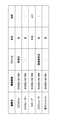
- FIG. 8 is a diagram showing an example of a stopover list.
- the stopover list in FIG. 8 is a node that appears when each node information included in the route information of FIG. 5 and each facility information shown in FIG. 7 move from the departure point of the target route toward the destination. Or the information is arranged in the order of the facilities.
- the node and the facility are not distinguished, it is referred to as "waypoint information"
- the node information and the facility information are not distinguished, it is referred to as "waypoint information”. That is, the waypoint list is a list of waypoint information.
- the presentable modality imparting unit 13 inputs the waypoint list output from the waypoint list generation unit 12, and executes the loop processing of steps S105 to S107 for each waypoint information included in the waypoint list. ..
- the waypoint information that is the processing target in the loop processing is referred to as "target waypoint information”.
- the presentable modality giving unit 13 determines whether the target waypoint information is node information or facility information. For example, if the value of the item in the first column of the target waypoint information includes a character string in the format of "node N" (N is an integer), the presentable modality giving unit 13 may use the target waypoint information. May be determined to be node information, otherwise it may be determined that the target waypoint information is facility information. Alternatively, a flag indicating whether the waypoint information is node information or facility information may be added to each waypoint information in the waypoint list by the waypoint list generation unit 12. In this case, the presentable modality giving unit 13 may determine whether the target waypoint information is node information or facility information based on the flag.
- the presentable modality giving unit 13 reads the rule information regarding the addition of the presentable modality to the node information from the rule information storage unit 123, and the presentable modality giving unit 13 reads the rule information.
- a presentable modality attribute is assigned to the node information (hereinafter, referred to as “target node information”) (S106).
- target node information a presentable modality attribute assigned to the node information (hereinafter, referred to as “target node information”) (S106).
- target node information hereinafter, referred to as “target node information”.
- “modality” means a sensory modality.
- the presentable modality of a node means a feeling (sensory modality) that can be made to the user with respect to the node.
- FIG. 9 is a diagram showing an example of rule information for node information.
- FIG. 9 shows rule information (r1) to (r4).
- the presentable modality giving unit 13 gives "visual" to the target node information based on the rule information (r1). That is, "vision” is specified as a candidate for the sensation of the node related to the target node information.
- the node related to the target node information is a turning angle, and information that the target node information turns to the right / left can be presented by using a force sense display or the like.
- the presentable modality giving unit 13 gives "force sense” to the target node information based on the rule information (r2). That is, "force sense” is specified as a candidate for the sensation felt with respect to the node related to the target node information.
- the presentable modality giving unit 13 uses the "force sense" as the target node information based on the rule information (r3). Give.
- the node information immediately before the target node information means the last node information among the node information before the target node information in the waypoint list. Therefore, the facility information does not correspond to the node information.
- the node related to the target node has a hierarchical movement, and the feeling of ascending / descending can be presented as dynamism information. 13 adds "force sense" to the target node information based on the rule information (r4). That is, "force sense” is specified as a candidate for the sensation felt with respect to the node related to the target node information.
- the sense of "force sense” given based on each of the rules (r2) to (r4) is different. Therefore, the presentable modality attribute may be given so that each sense is distinguished, not simply "force sense”.
- the "force sense” given based on the rule information (r2) is “force sense (right)” or “force sense (left)”, and the “force sense” given based on the rule information (r3).
- “Is a" force sense (gradient) ", and the” force sense “given based on the rule information (r4) may be a” force sense (hierarchical movement) ".
- the presentable modality giving unit 13 reads the rule information for the facility information from the rule information storage unit 123, and the facility information (hereinafter, referred to as “)” according to the rule information.
- a modality attribute that can be presented is added to (referred to as "target facility information") (S107).
- FIG. 10 is a diagram showing an example of rule information for facility information.
- the rule information for the facility information includes the “presentable modality” in association with the facility name.
- the "presentable modality” is information indicating a sense (sensory modality) that can be made to be felt by the user regarding the facility.
- the appearance of the stairs can be presented as visual information, and the footsteps going up and down the stairs can be presented as auditory information.
- the sensation of vibration when going up and down and the sensation of going up and down can be presented as tactile information and force sensation information. Therefore, in the example of FIG. 10, the rule information for imparting "visual", “hearing”, “tactile” and “force” to the stairs (that is, “visual”, “hearing”, “tactile” and “tactile” with respect to the stairs. Rule information) showing that it is possible to make people feel "force” is shown.
- the sound sign toilet can present the appearance as visual information and can also be presented as auditory information because it emits a sound sign, in the example of FIG. 10, the sound sign toilet is "visual" and "auditory”.
- the rule information to give “" that is, the rule information indicating that it is possible to make “visual” and “hearing” felt with respect to the sound sign toilet.
- the appearance of the wall can be presented as visual information
- the state of sound reverberation can be presented as auditory information
- the vibration when traveling through the wall with a white cane or the like can be presented as tactile information.
- the modality that can be presented is not always uniquely determined. Therefore, the sensation to be given and the method of giving the sensation may be stored as a set. For example, when presenting the force sense information of the gradient using a treadmill or the like, the "sense of climbing the gradient" and the inclination control information of the treadmill "+3 degrees" are stored as a set, and the set is stored. It may be given as a modality that can be presented.
- step S107 the presentable modality giving unit 13 identifies the sensory modality related to the presentable modality attribute associated with the facility name of the target facility information as a candidate for the sensation to be felt with respect to the facility related to the target facility information.
- the presentable modality attribute is given to the target facility information.
- each waypoint information in the waypoint list is given a modality attribute that can be presented (that is, a state in which a candidate for a feeling regarding each waypoint information in the waypoint list is specified). It becomes.
- FIG. 11 is a diagram showing an example of a waypoint list to which a modality attribute that can be presented is given.
- the types of modality that can be presented are not limited to this. For example, depending on the type of sensation display that can be presented (the type of sensation display that constitutes the output device 20), a modality that can present a pain sensation or a temperature sensation in addition to these sensations may be used.
- the presentable modality giving unit 13 outputs a waypoint list to which the presentable modality attribute is given (hereinafter, simply referred to as "waypoint list") to the guidance information presenting unit 14.
- the guidance information presenting unit 14 inputs the waypoint list output from the presentable modality giving unit 13, and generates guidance information based on the waypoint list (S108).
- the guidance information may be information showing the location of each waypoint on a map of the area including the target route, information that explains in advance the route from the departure point to the destination of the target route, or the target route. Navigation information that presents the route in real time according to the above movement may be used.
- the information for explaining the route in advance means information for explaining the route in a place different from the target route, such as at home.
- the guidance information presentation unit 14 goes through any one or more of the type of disability of the user, the spatial cognitive characteristics, the memory method that is good at (hereinafter, these are collectively referred to as "user characteristic information"), and the like.
- user characteristic information Based on the presentable modality attributes given to each waypoint information included in the place list, the waypoint information included in the guidance information and the feeling that the user feels when guiding the target route based on the guidance information are selected.
- the guidance information that is easy for the user to understand (that is, suitable for the user) may be generated.
- the user characteristic information may be input by the user in advance. For example, user characteristic information may be input together with the starting point and the destination.
- the user characteristic information may be information indicating a sensory modality that can be felt by the user, information indicating the spatial cognitive characteristics of the user, or information indicating a storage method that the user is good at.
- the guidance information presentation unit 14 transmits the generated guidance information to the output device 20 (S109).
- the output device 20 presents (outputs) guidance regarding the target route based on the guidance information.
- FIG. 12 is a diagram showing a first presentation example of guidance information.
- FIG. 12 shows an example in which the route of the target route is used as guidance information for the hearing impaired to explain in advance using visual information.
- the guidance information presenting unit 14 provides information that can be visually presented to the user's output device 20, such as an image showing the cafe c1, the Braille block b1 and the escalator e1, and the explanatory text t1 showing the directions. Send.
- the waypoint information included in the waypoint list the waypoint information to which "visual" is given as the "presentable modality attribute" is selected as the image transmission target.
- An image may be included in each waypoint information in advance.
- the explanatory text t can be generated based on the waypoint list.
- the output device 20 outputs an image showing the cafe c1, the Braille block b1 and the escalator e1, an explanatory text t1 showing directions, and the like based on the information received from the guidance information presenting unit 14.
- Such an image or explanatory text t1 may be output by a display, a projector, or the like constituting the output device 20. Since FIG. 12 is an example of explaining the route in advance, the explanatory text t1 may change according to the route with the passage of time, and the output image may change with the change of the explanatory text t1. ..
- FIG. 13 is a diagram showing a second presentation example of guidance information.
- FIG. 13 shows an example in which information for which the route of the target route is explained in advance for the visually impaired by using auditory information and tactile information is used as guidance information.
- the guidance information presentation unit 14 transmits information that can be presented audibly or tactilely to the user's output device 20.
- the guidance information presentation unit 14 transmits voice data corresponding to each facility, an output command of a force sense to turn to the right, voice data of an explanation indicating the route of the output route, and the like to the output device 20.
- the target to which the voice data, tactile or force output command is transmitted is given "hearing", “tactile” or "force” as the "presentable modality attribute". It is the waypoint information that has been done.
- the output device 20 outputs voice data or outputs a tactile sense or a force sense based on the information received from the guidance information presenting unit 14.
- the tactile or force sensation may be output by the tactile display or the force sensation display.
- the change in gradient may be output using a treadmill or the like.
- the odor may be output using an olfactory display or the like, or the taste may be output using an electric taste sensation that stimulates the tongue with an electric current to make the taste feel.
- the output format of the guidance information may be changed according to the spatial cognitive characteristics of the user. For example, if the user characteristic information includes information indicating that the user has spatial cognitive characteristics that form a survey map type cognitive map from a bird's-eye view, it is necessary to be able to imagine the entire route. , The guidance information presenting unit 14 shows the whole image of the target route in which the positions of the nodes or facilities related to the waypoint information whose "presentable modality attribute" includes "visual" in the waypoint list are plotted. Guidance information including an image may be generated and the guidance information may be transmitted to the output device 20.
- the guidance information presentation unit 14 relates to the waypoint information in which "visual", “tactile” and “force” are included in the "presentable modality attribute" in the waypoint list.
- Guidance information including an image of a first-person viewpoint including a node or facility may be generated for a target route, and the guidance information may be transmitted to the output device 20.
- the output format of the guidance information may be changed according to the storage method or the like that the user is good at. For example, if the user feature information includes information indicating that the user is good at visually storing the information, the guidance information presenting unit 14 is set in the "presentable modality attribute" in the waypoint list. Images and the like related to waypoint information including "visual sense” may be preferentially output. Further, when the user characteristic information includes information indicating that the user is good at memorizing the information aurally, the guidance information presenting unit 14 is set in the "presentable modality attribute" in the waypoint list. The voice or the like related to the waypoint information including "hearing” may be preferentially output.
- the user characteristic information includes information indicating that the user has a synesthesia such as feeling a color in the sound
- the auditory information is easier to be memorized.
- the voice or the like related to the waypoint information whose "presentable modality attribute" includes “hearing” may be preferentially output.
- a sensory candidate (modality attribute that can be presented) that makes the user feel about each node and each facility in the target route is specified. Therefore, it is possible to contribute to the generation of guidance information suitable for the user (according to the characteristics of the user's information acquisition and information understanding).
- FIG. 14 is a flowchart for explaining a method of generating guidance information according to the spatial cognitive characteristics of the user.
- step S108-1 the guidance information presentation unit 14 determines whether or not the user's spatial cognitive characteristics (hereinafter referred to as “target space cognitive characteristics”) included in the user characteristic information are route map type (survey map type). Or) is determined.
- target space cognitive characteristics hereinafter referred to as “target space cognitive characteristics”.
- the guidance information presenting unit 14 executes the processes from step S108-2 to step S108-6 to guide the route map type. Generate information.
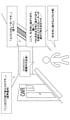
- FIG. 15 is a diagram showing an example of guidance information for the route map type.
- the same parts as those in FIG. 12 or the corresponding parts are designated by the same reference numerals.
- the guidance information presenting unit 14 executes the processes from step S108-7 to step S108-11 for the survey map type. Generate guidance information.
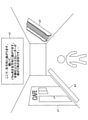
- FIG. 16 is a diagram showing an example of guidance information for the survey map type.
- the same parts as those in FIG. 15 or the corresponding parts are designated by the same reference numerals.
- Both FIGS. 15 and 16 are guidance information for explaining in advance the route from the departure point to the destination of the target route.
- steps S108-2 to S108-6 will be described in detail.
- step S108-2 the guidance information presenting unit 14 generates a first-person viewpoint image regarding the waypoints related to the waypoint information by using the waypoint information whose presentable modality attribute includes “visual”. Include the image in the guidance information. That is, the image is selected as guidance information.
- the image is an image of each facility shown in FIG. In FIG. 15, an image in which routes and facilities are arranged from a first-person viewpoint as if they were actually walking on the spot is generated.
- the guidance information presenting unit 14 uses the waypoint information whose presentable modality attribute includes "hearing” to obtain voice information heard from the direction corresponding to the first-person viewpoint with respect to the waypoint related to the waypoint information. Generate and include the voice information in the guidance information (S108-3). That is, the voice information is selected as guidance information.
- the voice information is the voice information shown by a broken line balloon with respect to the escalator e1 in FIG. In this case, the positional relationship between the current location and the sound source (elevator e1) corresponds to the first-person viewpoint as if actually walking on the spot, and at first, the sound sign is reproduced so that it can be heard from the front right. It is played back so that it can be heard from the right side gradually as it goes straight.
- the voice information may be output from headphones, a speaker of a smartphone, a speaker installed in the environment, or the like.
- the guidance information presentation unit 14 uses the information of "turning direction” and "left and right” in the waypoint list to correspond to the traveling direction and position in the sentence explaining the route (explanatory sentence t1) from the first-person viewpoint.
- the sound sentence (explanatory sentence) is included in the guidance information (S108-4). That is, the explanation is selected as guidance information.
- the explanatory text t1 in FIG. 15 is generated in terms of the direction of travel and the position corresponding to the first-person viewpoint, and is "straight ahead", “right”, “left”, according to the appearance when one is standing on the spot. "Front” etc. are expressed.
- the guidance information presenting unit 14 uses the waypoint information in which the presentable modality attribute includes "force sense", and the force sense information in the direction corresponding to the first-person viewpoint with respect to the waypoint related to the waypoint information. Is included in the guidance information (S108-5). That is, the force sense information is selected as guidance information.
- the lower right of FIG. 15 shows an example of force sensation information when the traction force information corresponding to the traveling direction is presented from the smartphone terminal.
- the direction of travel and the direction of force sensory information correspond to the first-person viewpoint, and when the smartphone is held vertically and horizontally, the force is pulled in the same direction as the direction of travel in the first-person viewpoint.
- Sense information is presented.
- force sensory information may be generated using the technology of Burunabi (registered trademark) (Patent No. 6509698, "TOMOHIRO AMEMIYA, HIDEYUKI ANDO and TARO MAEDA, Lead-Me Interface for a Pulling Sensation from Hand”. -held Devices, ACM Transactions on Applied Perception, Vol. 5, No. 3, Article 15, Publication date: August 2008. ”).
- Burunabi registered trademark
- Patent No. 6509698 Patent No. 6509698, "TOMOHIRO AMEMIYA, HIDEYUKI ANDO and TARO MAEDA, Lead-Me Interface for a Pulling Sensation from Hand”.
- -held Devices ACM Transactions on Applied Perception, Vol. 5, No. 3, Article 15, Publication date: August 2008. ”).
- the guidance information presentation unit 14 generates tactile information in the direction corresponding to the first-person viewpoint with respect to the waypoints related to the waypoint information, using the waypoint information whose presentable modality attribute includes "tactile sensation". Then, the tactile information is included in the guidance information (S108-6). That is, the tactile information is selected as guidance information.
- the tactile information is selected as guidance information.
- FIG. 15 an example of tactile information is shown in the balloon of the Braille block b1.
- the direction of the tactile information corresponds to the first-person viewpoint, and when a device capable of presenting vibration such as a smartphone is held, the vibration is presented on the left side of the device.
- step S108-7 the guidance information presenting unit 14 generates a bird's-eye view image of the waypoints related to the waypoint information by using the waypoint information whose presentable modality attribute includes “visual”. Include the image in the guidance information. That is, the image is selected as guidance information.
- the image is an image of each facility shown in FIG. In FIG. 16, an image in which routes and facilities are arranged is generated from a bird's-eye view as if the map is viewed from above.
- the guidance information presenting unit 14 uses the waypoint information whose presentable modality attribute includes "hearing” to obtain voice information that can be heard from the direction corresponding to the bird's-eye view with respect to the waypoint related to the waypoint information. Generate and include the voice information in the guidance information (S108-8). That is, the voice information is selected as guidance information.
- the positional relationship between the current location and the sound output corresponds to a bird's-eye view as if the map is viewed from above. At first, the sound sign is reproduced so that it can be heard from the left, and then to the left. As you proceed, the display position of the escalator gradually becomes the front, and it is played so that it can be heard from the front.
- the voice information may be output from headphones, a speaker of a smartphone, a speaker installed in the environment, or the like.
- the guidance information presentation unit 14 uses the information of the "turning direction" and "left and right” of the waypoint list to correspond to the traveling direction and the position in the sentence explaining the route (explanatory sentence t1) from the bird's-eye view. Generated by expression and include the sound sentence (explanatory sentence) in the guidance information (SS108-9). That is, the explanation is selected as guidance information.
- the explanatory text t1 in FIG. 16 is generated by expressing the traveling direction and position corresponding to the bird's-eye view, and is "top", “bottom”, “right”, and “left” according to the appearance when the map is viewed from above. "Etc. are expressed.
- the guidance information presenting unit 14 uses the waypoint information whose presentable modality attribute includes "force sense", and the force sense information in the direction corresponding to the bird's-eye view with respect to the waypoint related to the waypoint information. Is included in the guidance information (S108-10). That is, the force sense information is selected as guidance information.
- An example of traction force information when presenting traction force information corresponding to the traveling direction from a smartphone terminal is shown in the lower right of FIG. 16 (for example, an image of Burunabi (registered trademark)). In FIG.
- the direction of travel and the direction of force information correspond to the bird's-eye view, and when the user holds the smartphone vertically and horizontally, it is pulled in the same direction as the direction of travel in the bird's-eye view.
- Power sense information is presented.
- the force sense information may indicate the direction of travel by tilting the smartphone.
- Burunabi registered trademark
- the guidance information presentation unit 14 generates tactile information in the direction corresponding to the bird's-eye view with respect to the waypoints related to the waypoint information, using the waypoint information whose presentable modality attribute includes "tactile sensation". Then, the tactile information is included in the guidance information (S108-11). That is, the tactile information is selected as guidance information.
- the tactile information is selected as guidance information.
- FIG. 16 an example of tactile information is shown in the balloon of the Braille block b1.
- the direction of the tactile information corresponds to the bird's-eye view, and when a device capable of presenting vibration such as a smartphone is held, the vibration is presented on the lower side of the device.
- the waypoint list generation unit 12 is an example of a specific unit.
- the guidance information presentation unit 14 is an example of a selection unit.
- the facility information storage unit 122 is an example of the first storage unit.
- the rule information storage unit 123 is an example of a second storage unit.
- Guidance information processing device 11 Input section 12 Waypoint list generation section 13 Presentable modality addition section 14 Guidance information presentation section 20 Output device 100 Drive device 101 Recording medium 102 Auxiliary storage device 103 Memory device 104 CPU 105 Interface device 106 Display device 107 Input device 121 Route information storage unit 122 Facility information storage unit 123 Rule information storage unit B Bus
Landscapes
- Engineering & Computer Science (AREA)
- Radar, Positioning & Navigation (AREA)
- Remote Sensing (AREA)
- Automation & Control Theory (AREA)
- Physics & Mathematics (AREA)
- General Physics & Mathematics (AREA)
- Navigation (AREA)
Abstract
案内情報処理装置は、施設ごとに位置情報を記憶した第1の記憶部を参照して、ユーザによる指定に基づく経路に存在する1以上の施設を特定する特定部と、前記施設ごとに当該施設に関して感じさせることが可能な感覚を示す情報を記憶した第2の記憶部を参照して、前記特定部が特定した施設について、前記経路の案内に際して当該施設に関して前記ユーザに感じさせる感覚を、前記ユーザの空間認知特性に基づいて選択する選択部と、を有することで、ユーザに適した案内情報の生成に寄与する。
Description
本発明は、案内情報処理装置、案内情報処理方法及びプログラムに関する。
従来より、地図情報に基づいて、目的地までの案内情報を提示するシステムが提案されている。例えば、特許文献1記載の技術では、ユーザが認知しやすいランドマーク情報に基づいて、目的地までの道順等の案内情報をユーザに提示することで、どのような場所を歩くのかを事前にわかりやすく理解させている。
また、地図情報に様々な属性を持たせることで、目的地までの道順等の案内情報の生成に用いる情報の取捨選択等を可能にする技術も提案されている。例えば、非特許文献1では、ランドマークの名称や写真、住所に加えて、施設のカテゴリ、関連webサイト、電話番号、営業時間、口コミ等の属性を地図情報に持たせている。非特許文献2では最寄り駅からの距離等の属性も地図情報に持たせている。
インターネット<URL:https://www.google.com/maps/?hl=ja>
インターネット<URL:https://www.its-mo.com/>
非特許文献1、2では、地図情報に様々な属性を持たせることで、特定の属性の特定の値を持つランドマークのみをユーザに提示するといった処理が可能となっている。
他方において、ユーザの障がいの種類や、空間認知特性、得意とする記憶法等によって、ユーザが利用可能な情報やわかりやすい情報は異なるが、現状では、地図情報に基づいて目的地までの道順等の案内情報を生成する際、その地図情報が視覚で提示可能か、聴覚で提示可能か、触覚で提示可能か等の属性が設定されていない。
本発明は、上記の点に鑑みてなされたものであって、ユーザに適した案内情報の生成に寄与することを目的とする。
そこで上記課題を解決するため、案内情報処理装置は、施設ごとに位置情報を記憶した第1の記憶部を参照して、ユーザによる指定に基づく経路に存在する1以上の施設を特定する特定部と、前記施設ごとに当該施設に関して感じさせることが可能な感覚を示す情報を記憶した第2の記憶部を参照して、前記特定部が特定した施設について、前記経路の案内に際して当該施設に関して前記ユーザに感じさせる感覚を、前記ユーザの空間認知特性に基づいて選択する選択部と、を有する。
ユーザに適した案内情報の生成に寄与することができる。
以下、図面に基づいて本発明の実施の形態を説明する。図1は、第1の実施の形態におけるシステム構成例を示す図である。図1において、案内情報処理装置10と1以上の出力装置20とは、例えば、インターネット等のネットワークを介して接続される。
出力装置20は、ユーザから入力情報を受け付けたり、当該入力情報に基づいて案内情報処理装置10によって生成される情報に基づく出力を行ったりする装置である。簡易な出力装置20の例として、スマートフォンやPC(Personal Computer)等が挙げられるが、出力装置20は、例えば、液晶ディスプレイ、力覚ディスプレイ、嗅覚ディスプレイ、スピーカ等、人の五感(感覚モダリティ)によって知覚できる感覚又は情報を出力可能な複数の装置によって構成されてもよい。例えば、出力装置20が、スマートフォン等、携帯可能な装置であれば、ユーザは、任意の場所で出力装置20を利用することができる。一方、出力装置20が、ユーザの自宅や、所定の場所(例えば、案内情報処理装置10によって生成される情報を効果的に出力するために設けられた場所)に固定されているのであれば、ユーザは、自宅又は所定の場所において出力装置20を利用することができる。所定の場所には、遊園地等のアトラクションが含まれてもよい。
案内情報処理装置10は、ユーザから(出力装置20から)要求された情報を、ユーザの情報理解の特徴に応じた形式で生成する1以上のコンピュータである。本実施の形態では、出発地及び目的地が、ユーザによって出力装置20に入力され、出発地から目的地までの経路に関する案内情報が案内情報処理装置10によって生成される例を説明する。
図2は、第1の実施の形態における案内情報処理装置10のハードウェア構成例を示す図である。図2の案内情報処理装置10は、それぞれバスBで相互に接続されているドライブ装置100、補助記憶装置102、メモリ装置103、CPU104、及びインタフェース装置105等を有する。
案内情報処理装置10での処理を実現するプログラムは、CD-ROM等の記録媒体101によって提供される。プログラムを記憶した記録媒体101がドライブ装置100にセットされると、プログラムが記録媒体101からドライブ装置100を介して補助記憶装置102にインストールされる。但し、プログラムのインストールは必ずしも記録媒体101より行う必要はなく、ネットワークを介して他のコンピュータよりダウンロードするようにしてもよい。補助記憶装置102は、インストールされたプログラムを格納すると共に、必要なファイルやデータ等を格納する。
メモリ装置103は、プログラムの起動指示があった場合に、補助記憶装置102からプログラムを読み出して格納する。CPU104は、メモリ装置103に格納されたプログラムに従って案内情報処理装置10に係る機能を実行する。インタフェース装置105は、ネットワークに接続するためのインタフェースとして用いられる。
図3は、第1の実施の形態における案内情報処理装置10の機能構成例を示す図である。図3において、案内情報処理装置10は、入力部11、経由地リスト生成部12、提示可能モダリティ付与部13及び案内情報提示部14等を有する。これら各部は、案内情報処理装置10にインストールされた1以上のプログラムが、CPU104に実行させる処理により実現される。案内情報処理装置10は、また、経路情報記憶部121、施設情報記憶部122及びルール情報記憶部123を利用する。これら各記憶部は、例えば、補助記憶装置102、又は案内情報処理装置10にネットワークを介して接続可能な記憶装置等を用いて実現可能である。
以下、案内情報処理装置10が実行する処理手順について説明する。図4は、案内情報処理装置10が実行する処理手順の一例を説明するためのフローチャートである。
ステップS101において、入力部11は、出発地及び目的地を示す情報を出力装置20から受信する(受け付ける)。入力部11は、入力された情報を経由地リスト生成部12へ出力する。当該情報は、出力装置20に対してユーザによって入力(指定)された情報である。なお、ユーザによる出発地及び目的地の入力の目的は様々であってよい。例えば、現在地からのリアルタイムでの経路案内(ナビゲーション)が目的とされてもよいし、数日後の外出時における経路の予習が目的とされてもよいし、単なる興味本位が目的とされてもよい。
続いて、経由地リスト生成部12は、入力部11から出力された出発地及び目的地を示す情報を入力とし、当該情報に合致する経路情報(以下、「対象経路情報」という。)を経路情報記憶部121から取得する(S102)。
図5は、経路情報の一例を示す図である。図5に示されるように、経路情報は、或る地点から或る地点までの経路を複数のノードとノード間を接続するリンクとで表現した情報である。ノードとは、当該経路を線分の集合で表現するために必要とされる地点であり、ノードとして選択される地点は、経路をどの程度の精度で表現するかに応じて異なってもよい。例えば、或る地点と或る地点との間がほぼ直線の経路であれば、当該2つの地点の間にはノードは設けられなくてもよい。一方、或る地点と或る地点との間に曲線の経路が含まれるのであれば、当該曲線を表現するために必要なノードが当該2つのノード間に設けられればよい。すなわち、ノードとは、後述されるPOI(Point Of Interest)とは異なり、必ずしも実在する施設等ではなく、経路を表現するために便宜的に設定される地点である。
なお、図5に示される経路情報は、出発地が「A駅1番出口」であり、目的地が「〇〇タワー」である場合に取得される経路情報の例(すなわち、対象経路情報の例)である。
具体的には、経路情報は、出発地から目的地までに経由するノードの順番で、各ノードのノード情報を含む。ノード情報は、「緯度経度」、「曲がる方向」、「次ノードまでの距離」、「次ノードまでの勾配」、「次ノードまでの階層移動」等の属性を含む。但し、これより多くの属性がノード情報に含まれてもよい。なお、経路情報において1番目のノード情報は出発地に対応し、最後のノード情報は目的地に対応する。
或るノードの「緯度経度」は、当該ノードに対応する地点の位置情報(緯度及び経度)である。或るノードの「曲がる方向」は、当該ノード(地点)において、ユーザから見て曲がる方向である。或るノードの「次ノードまでの距離」は、経路において当該ノードの次のノード(以下、単に「次ノード」という。)までの距離である。或るノードの「次ノードまでの勾配」は、当該ノードから次ノードまでの勾配である。或るノードの「次ノードまでの階層移動」とは、当該ノードと次ノードとの間に建造物の階の移動が含まれる場合に、当該階の移動が何階分の移動かを示す情報である。0は、階の移動が無いことを示す。プラスの符号(+)が付与された値は、上り方向に当該値分の階の移動が有ることを示す。マイナスの符号(-)が付与された値は、下り方向に当該値分の階の移動が有ることを示す。
なお、経路情報記憶部121には、或る2地点を入力として、図5に示されるような経路情報を取得可能な情報が記憶されていればよい。例えば、ナビゲーションシステムの地図情報と同様の情報が記憶されていてもよい。この場合、経由地リスト生成部12は、出発地から目的地までの経路を当該地図情報から探索し、探索された経路を示す経路情報を生成してもよい。
続いて、経由地リスト生成部12は、対象経路情報が示す経路(以下、「対象経路」という。)の沿道や対象経路上に位置する施設を施設情報記憶部122を参照して特定し、特定した施設(対象経路において経由する施設)に関する情報(以下、「施設情報」という。)を施設情報記憶部122から取得する(S103)。
図6は、施設情報記憶部122の構成例を示す図である。図6に示されるように、施設情報記憶部122には、施設ごとに、「施設名」、「緯度経度」及び、「ジャンル」等が記憶されている。但し、これより多くの属性が施設情報に含まれてもよい。
或る施設の「施設名」は、当該施設の名称である。当該名称は、一般名称であってもよいし、特定の店舗名等の固有名称であってもよい。或る施設の「緯度経度」は、当該施設の位置情報(緯度及び経度)である。「ジャンル」は、特に店舗である施設に有効な属性であり、当該施設が属するジャンルである。なお、施設は、ナビゲーションシステムにおいてPOI(Point Of Interest)として登録される物でもよい。
例えば、経由地リスト生成部12は、各施設の「緯度経度」の値と、対象経路情報とに基づいて対象経路上又は対象経路沿いの施設を特定し、当該施設の施設情報を施設情報記憶部122から取得してもよい。なお、経由地リスト生成部12は、取得した各施設情報を、対象経路を出発地から目的地の方向に移動した場合の出現順に整列すると共に、当該各施設情報に対して、「左右」及び「向き」の属性を付加する。「左右」は、出発地から目的地の方向に対象経路を移動する際に、いずれの方向に施設が存在するのかを示す情報であり、「左」、「右」及び「中央」等のいずれかの値となる。「左」は、左側を意味し、「右」は、右側を意味し、「中央」は、中央(正面)を意味する。「左右」は、施設情報の「緯度経度」と対象経路とに基づいて特定可能である。「向き」は、階段、段差、坂等、上下方向への移動が必要とされる施設に有効な属性であり、上りであるのか下りであるのかを示す情報である。
したがって、ステップS103では、例えば、図7に示されるような施設情報が取得される。図7は、施設情報の取得結果の一例を示す図である。図7には、図6から5つの施設情報が取得された例が示されている。上記したように、図7における施設情報は、対象経路を出発地から目的地の方向に移動した場合の出現順に整列され、各施設情報には「左右」及び「向き」が付加されている。
続いて、経由地リスト生成部12は、取得した経路情報(図5)及び取得した施設情報(図7)に基づいて経由地リストを生成し、生成した経由地リストを提示可能モダリティ付与部13へ出力する(S104)。
図8は、経由地リストの一例を示す図である。図8における経由地リストは、図5の経路情報に含まれる各ノード情報と、図7に示される各施設情報とが、対象経路の出発地から目的地の方向へ移動した場合に出現するノード又は施設の順番に整列された情報である。なお、以下において、ノード及び施設を区別しない場合「経由地」といい、ノード情報及び施設情報を区別しない場合、「経由地情報」という。すなわち、経由地リストは、経由地情報のリストである。
続いて、提示可能モダリティ付与部13は、経由地リスト生成部12から出力された経由地リストを入力とし、ステップS105~S107のループ処理を、経由地リストに含まれる経由地情報ごとに実行する。以下、当該ループ処理において処理対象とされている経由地情報を「対象経由地情報」という。
ステップS105において、提示可能モダリティ付与部13は、対象経由地情報がノード情報であるのか施設情報であるのかを判定する。例えば、対象経由地情報の1列目の項目の値に「ノードN」(Nは、整数)の形式である文字列が含まれていれば、提示可能モダリティ付与部13は、対象経由地情報がノード情報であると判定し、そうでなければ、対象経由地情報が施設情報であると判定してもよい。又は、経由地リストの各経由地情報に対して、当該経由地情報がノード情報であるのか施設情報であるのかを示すフラグが経由地リスト生成部12によって付与されていてもよい。この場合、提示可能モダリティ付与部13は、当該フラグに基づいて、対象経由地情報がノード情報であるのか施設情報であるのかを判定してもよい。
対象経由地情報がノード情報である場合(S105でYes)、提示可能モダリティ付与部13は、ルール情報記憶部123からノード情報に対しての提示可能モダリティの付与に関するルール情報を読み出し、当該ルール情報に従って当該ノード情報(以下、「対象ノード情報」という。)に対して提示可能モダリティ属性を付与する(S106)。なお、本実施の形態において「モダリティ」とは、感覚モダリティのことを意味する。また、ノードについての提示可能モダリティとは、当該ノードに関してユーザに対して感じさせることが可能な感覚(感覚モダリティ)をいう。
図9は、ノード情報に対するルール情報の一例を示す図である。図9には、ルール情報(r1)~(r4)が示されている。
まず全てのノードはその地点を視覚情報として提示することができるため、提示可能モダリティ付与部13は、ルール情報(r1)に基づいて、対象ノード情報に「視覚」を付与する。すなわち、対象ノード情報に係るノードに関して感じさせる感覚の候補として「視覚」が特定される。
また、対象ノード情報が、「曲がる方向」に値を持つ場合、対象ノード情報に係るノードは曲がり角であり、右/左に曲がるという情報を力覚ディスプレイ等を用いて提示することができるため、提示可能モダリティ付与部13は、ルール情報(r2)に基づいて「力覚」を対象ノード情報に付与する。すなわち、対象ノード情報に係るノードに関して感じさせる感覚の候補として「力覚」が特定される。
また、対象ノード情報の「次ノードまでの勾配」の値が0%でない場合、又は対象ノード情報の「次ノードまでの勾配」の値が0%であるが対象ノード情報の一つ前のノード情報の「次ノードまでの勾配」の値が0%でない場合(すなわち、対象ノード情報の「次ノードまでの勾配」の値が、一つ前のノード情報の「次ノードまでの勾配」と異なる場合)、対象ノード情報に係るノードでは、勾配の傾き及び変化量を力覚として提示できるため、提示可能モダリティ付与部13は、ルール情報(r3)に基づいて「力覚」を対象ノード情報に付与する。すなわち、対象ノード情報に係るノードに関して感じさせる感覚の候補として「力覚」が特定される。なお、対象ノード情報の一つ前のノード情報とは、経由地リストにおいて、対象ノード情報より前のノード情報のうち最後のノード情報をいう。したがって、施設情報は、当該ノード情報には該当しない。
また、対象ノード情報の「次ノードまでの階層移動」の値が0でない場合、対象ノードに係るノードは階層移動があり、その昇降の感覚を力覚情報として提示できるため、提示可能モダリティ付与部13は、ルール情報(r4)に基づいて「力覚」を対象ノード情報に付与する。すなわち、対象ノード情報に係るノードに関して感じさせる感覚の候補として「力覚」が特定される。
なお、ルール(r2)~ルール(r4)のそれぞれに基づいて付与される「力覚」の感覚はそれぞれ異なる。したがって、単に「力覚」ではなく、それぞれの感覚が区別されるように提示可能モダリティ属性が付与されてもよい。例えば、ルール情報(r2)に基づいて付与される「力覚」は「力覚(右)」又は「力覚(左)」とされ、ルール情報(r3)に基づいて付与される「力覚」は「力覚(勾配)」とされ、ルール情報(r4)に基づいて付与される「力覚」は「力覚(階層移動)」とされてもよい。
一方、対象経由地情報が施設情報である場合(S105でNo)、提示可能モダリティ付与部13は、ルール情報記憶部123から施設情報に対するルール情報を読み出し、当該ルール情報に従って当該施設情報(以下、「対象施設情報」という。)に対して提示可能モダリティ属性を付与する(S107)。
図10は、施設情報に対するルール情報の一例を示す図である。図10に示されるように、施設情報に対するルール情報は、施設名に対応付けて「提示可能モダリティ」を含む。「提示可能モダリティ」は、施設に関してユーザに感じさせることが可能な感覚(感覚モダリティ)を示す情報である。
例えば、階段は、見た目を視覚情報として提示可能であり、階段を上り下りする足音は聴覚情報として提示可能である。また、上り下りする時の振動の感覚や昇降の感覚を触覚情報・力覚情報としても提示可能である。そのため、図10の例では、階段に対して「視覚」、「聴覚」、「触覚」及び「力覚」を付与するルール情報(すなわち、階段に関して「視覚」、「聴覚」、「触覚」及び「力覚」を感じさせることが可能であることを示すルール情報)が示されている。
また、音サイントイレは、見た目を視覚情報として提示可能であり、音サインを発するので聴覚情報としても提示可能であるため、図10の例では、音サイントイレに対して「視覚」及び「聴覚」を付与するルール情報(すなわち、音サイントイレに関して「視覚」及び「聴覚」を感じさせることが可能であることを示すルール情報)が示されている。
また、壁は、見た目を視覚情報として提示可能であり、かつ、音の反響の具合を聴覚情報として提示可能であり、白杖等で壁を伝うときの振動を触覚情報として提示可能であるため、図10の例では、壁に対して「視覚」、「聴覚」及び「触覚」を付与するルール情報(すなわち、壁に関して「視覚」、「聴覚」及び「触覚」を感じさせることが可能であることを示すルール情報)が示されている。
また、「○○カフェ」のように、ジャンルが飲食店であれば、見た目を視覚情報として提示可能であることに加えて、コーヒーの香りや味を嗅覚・味覚ディスプレイ等を用いて提示可能であるため、図10の例では、「○○カフェ」に対して「視覚」、「嗅覚」及び「味覚」を付与するルール情報(すなわち、「○○カフェ」に関して「視覚」、「嗅覚」及び「味覚」を感じさせることが可能であることを示すルール情報)が示されている。
なお、提示可能モダリティは、必ずしも一意に定まらない。そこで、付与したい感覚とその感覚の与え方が組にされて記憶されていてもよい。例えば、トレッドミルなどを用いて勾配の力覚情報を提示する場合は、「勾配の昇りの感覚」とトレッドミルの傾き制御情報「+3度」などを組にして記憶させておき、当該組が提示可能モダリティとして付与されてもよい。
ステップS107において、提示可能モダリティ付与部13は、対象施設情報の施設名に対応付けられている提示可能モダリティ属性に係る感覚モダリティを、対象施設情報に係る施設に関して感じさせる感覚の候補として特定し、当該提示可能モダリティ属性を対象施設情報に対して付与する。
ステップS105~S107のループ処理が、経由地リスト(図8)の全ての経由地情報に対して実行されると、当該ループ処理が終了する。この時点において、経由地リストの各経由地情報には提示可能モダリティ属性が付与された状態(すなわち、経由地リストの各経由地情報に係る経由地に関して感じさせる感覚の候補が特定された状態)となる。
図11は、提示可能モダリティ属性が付与された経由地リストの一例を示す図である。なお、提示可能モダリティの種類はこれだけには限られない。例えば、提示可能な感覚ディスプレイの種類(出力装置20を構成する感覚ディスプレイの種類)によっては、これらの感覚以外にも痛覚や温度感覚が提示可能モダリティとされてもよい。
提示可能モダリティ付与部13は、提示可能モダリティ属性が付与された経由地リスト(以下、単に「経由地リスト」という。)を案内情報提示部14へ出力する。
続いて、案内情報提示部14は、提示可能モダリティ付与部13から出力された経由地リストを入力とし、当該経由地リストに基づいて案内情報を生成する(S108)。案内情報は、対象経路を含むエリアの地図上に各経由地の位置が示された情報でもよいし、対象経路の出発地から目的地までの道順を事前に説明する情報でもよいし、対象経路上の移動に応じて当該道順をリアルタイムで提示するナビゲーション情報でもよい。なお、道順を事前に説明する情報とは、例えば、自宅等、対象経路とは異なる場所で当該道順を一通り説明する情報をいう。
この際、案内情報提示部14は、ユーザの障がいの種類、空間認知特性、得意とする記憶法等(以下、これらを総称して「ユーザ特徴情報」という。)のいずれか1以上と、経由地リストに含まれる各経由地情報に付与された提示可能モダリティ属性とに基づいて、案内情報に含める経由地情報、及び案内情報に基づく対象経路の案内に際してユーザに感じさせる感覚について取捨選択を行い、ユーザにとって理解が容易な(すなわち、ユーザに適した)案内情報を生成してもよい。なお、ユーザ特徴情報は、事前にユーザによって入力されてもよい。例えば、出発地及び目的地と共に、ユーザ特徴情報が入力されてもよい。ユーザ特徴情報は、ユーザが感じることが可能な感覚モダリティを示す情報であってもよいし、ユーザの空間認知特性を示す情報でもよいし、ユーザが得意とする記憶法を示す情報でもよい。
続いて、案内情報提示部14は、生成した案内情報を出力装置20へ送信する(S109)。出力装置20は、当該案内情報に基づいて、対象経路に関する案内を提示(出力)する。
図12は、案内情報の第1の提示例を示す図である。図12には、対象経路の道順が聴覚障がい者向けに視覚情報を用いて事前に説明する情報が案内情報とされる例が示されている。
この場合、案内情報提示部14は、ユーザの出力装置20に対して、カフェc1、点字ブロックb1及びエスカレーターe1を示す画像、並びに道順を示す説明文t1等、視覚的に提示が可能な情報を送信する。画像の送信対象として選択されるのは、経由地リストに含まれる経由地情報のうち、「提示可能モダリティ属性」として「視覚」が付与されている経由地情報である。なお、各経由地情報には画像が予め含まれていてもよい。説明文tは、経由地リストに基づいて生成可能である。
出力装置20は、案内情報提示部14から受信した情報に基づいて、カフェc1、点字ブロックb1及びエスカレーターe1を示す画像、並びに道順を示す説明文t1等を出力する。斯かる画像や説明文t1は、出力装置20を構成するディスプレイ又はプロジェクタ等によって出力されてもよい。なお、図12は、事前に道順を説明する例であるため説明文t1が時間の経過とともに道順に従って変化し、説明文t1の変化にともなって、出力される画像が変化するようにしてもよい。
図13は、案内情報の第2の提示例を示す図である。図13には、対象経路の道順が視覚障がい者向けに聴覚情報及び触覚情報を用いて事前に説明する情報が案内情報とされる例が示されている。
この場合、案内情報提示部14は、ユーザの出力装置20に対して、聴覚的又は触覚的に提示が可能な情報を送信する。例えば、案内情報提示部14は、各施設に対応した音声データや、右に曲がる力覚の出力命令や、出力経路の道順を示す説明の音声データ等を出力装置20へ送信する。音声データ、触覚又は力覚の出力命令が送信される対象は、経由地リストに含まれる経由地情報のうち、「提示可能モダリティ属性」として「聴覚」、「触覚」又は「力覚」が付与されている経由地情報である。
出力装置20は、案内情報提示部14から受信した情報に基づいて、音声データを出力したり、触覚又は力覚を出力したりする。触覚又は力覚は、触覚ディスプレイ又は力覚ディスプレイによって出力されてもよい。又は、トレッドミルなどを用いて勾配の変化が出力されてもよい。更に、嗅覚ディスプレイなどを用いて匂いが出力されてもよいし、電流で舌に刺激を与えて味を感じさせる電気味覚などを用いて味が出力されてもよい。
案内情報の出力形式は、ユーザの空間認知特性に応じて変えられてもよい。例えば、俯瞰視点のサーベイマップ型の認知地図を形成する空間認知特性のユーザであることを示す情報がユーザ特徴情報に含まれている場合、経路の全体像がイメージできることが必要だと考えられるため、案内情報提示部14は、経由地リストのうち「提示可能モダリティ属性」に「視覚」が含まれている経由地情報に係るノード又は施設の位置がプロットされた、対象経路の全体像を示す画像を含む案内情報を生成し、当該案内情報を出力装置20へ送信してもよい。
一方、一人称視点のルートマップ型の認知地図を形成する空間認知特性のユーザであることを示す情報がユーザ特徴情報に含まれている場合は、途中にどのような目印があるのかを体験を通してイメージできることが必要だと考えられるため、案内情報提示部14は、経由地リストのうち「提示可能モダリティ属性」に「視覚」、「触覚」及び「力覚」が含まれている経由地情報に係るノード又は施設を含む一人称視点の画像を含む案内情報を対象経路について生成し、当該案内情報を出力装置20へ送信してもよい。
更に、案内情報の出力形式は、ユーザが得意とする記憶法等に応じて変えられてもよい。例えば、情報を視覚的に記憶するのが得意なユーザであることを示す情報がユーザ特徴情報に含まれていれば、案内情報提示部14は、経由地リストのうち「提示可能モダリティ属性」に「視覚」が含まれている経由地情報に係る画像等を優先的に出力対象としてもよい。また、情報を聴覚的に記憶するのが得意なユーザであることを示す情報がユーザ特徴情報に含まれている場合、案内情報提示部14は、経由地リストのうち「提示可能モダリティ属性」に「聴覚」が含まれている経由地情報に係る音声等を優先的に出力対象としてもよい。更に、音に色を感じるような共感覚を持つユーザであることを示す情報がユーザ特徴情報に含まれている場合は、聴覚情報がより記憶しやすいと考えられるため、案内情報提示部14は、「提示可能モダリティ属性」に「聴覚」が含まれている経由地情報に係る音声等を優先的に出力対象としてもよい。
上述したように、第1の実施の形態によれば、対象経路における各ノード及び各施設についてユーザに感じさせる感覚の候補(提示可能モダリティ属性)が特定される。したがって、ユーザに適した(ユーザの情報取得や情報理解の特徴に応じた)案内情報の生成に寄与することができる。
次に、第2の実施の形態について説明する。第2の実施の形態において特に言及されない点については、第1の実施の形態と同様でもよい。第2の実施の形態では、図4のステップS108について、ユーザの空間認知特性に応じた案内情報の生成方法の詳細な一例について説明する。
図14は、ユーザの空間認知特性に応じた案内情報の生成方法を説明するためのフローチャートである。
ステップS108-1において、案内情報提示部14は、ユーザ特徴情報に含まれている、ユーザの空間認知特性(以下、「対象空間認知特性」という。)がルートマップ型か否か(サーベイマップ型か)を判定する。
対象空間認知特性がルートマップ型である場合(S108-1でYes)、案内情報提示部14は、ステップS108-2からステップS108-6までの処理を実行することで、ルートマップ型向けの案内情報を生成する。
図15は、ルートマップ型向けの案内情報の一例を示す図である。図15中、図12と同一部分又は対応する部分には同一符号を付している。
一方、対象空間認知特性がルートマップ型でない場合(S108-1でNo)、案内情報提示部14は、ステップS108-7からステップS108-11までの処理を実行することで、サーベイマップ型向けの案内情報を生成する。
図16は、サーベイマップ型向けの案内情報の一例を示す図である。図16中、図15と同一部分又は対応する部分には同一符号を付している。なお、図15及び図16のいずれもが、対象経路の出発地から目的地までの道順を事前に説明する案内情報である。
まず、ステップS108-2からステップS108-6について詳細に説明する。
ステップS108-2において、案内情報提示部14は、提示可能モダリティ属性に「視覚」が含まれている経由地情報を用いて、当該経由地情報に係る経由地に関して一人称視点の画像を生成し、当該画像を案内情報に含める。すなわち、当該画像が案内情報として選択される。当該画像は、図15に示される各施設の画像である。図15では、実際にその場を歩いているかのような一人称視点で経路や施設が配置された画像が生成する。
続いて、案内情報提示部14は、提示可能モダリティ属性に「聴覚」が含まれている経由地情報を用いて、当該経由地情報に係る経由地に関して一人称視点に対応した方向から聞こえる音声情報を生成し、当該音声情報を案内情報に含める(S108-3)。すなわち、当該音声情報が案内情報として選択される。当該音声情報は、図15において、エスカレーターe1に対する破線の吹き出しによって示される音声情報である。この場合、現在地と音の発生源(エレベーターe1)との位置関係が、実際にその場を歩いているかのような一人称視点に対応しており、最初は音サインが右前方から聞こえるように再生され、直進していくにつれて徐々に真右から聞こえるように再生される。音声情報はヘッドホンから出力されてもよいし、スマートフォンのスピーカ、環境に設置されたスピーカなどから出力されてよい。
続いて、案内情報提示部14は、経由地リストの「曲がる方向」、「左右」の情報を用いて、道順を説明する文章(説明文t1)中の進行方向や位置を一人称視点に対応した表現で生成し、当該音文章(説明文)を案内情報に含める(S108-4)。すなわち、当該説明文が案内情報として選択される。図15の説明文t1は、進行方向や位置が一人称視点に対応した表現で生成されており、自分がその場に立っているときの見え方に従って「直進」、「右」、「左」、「正面」等が表現されている。
続いて、案内情報提示部14は、提示可能モダリティ属性に「力覚」が含まれている経由地情報を用いて、当該経由地情報に係る経由地に関して一人称視点に対応した方向の力覚情報を生成し、当該力覚情報を案内情報に含める(S108-5)。すなわち、当該力覚情報が案内情報として選択される。図15の右下に、スマートフォン端末から進行方向に対応した牽引力情報を提示する場合の力覚情報の例を示す。図15では、進行方向と力覚情報の方向が一人称視点に対応しており、スマートフォンを縦に向けて水平に持っている場合、一人称視点での進行方向と同じ方向に牽引されるような力覚情報が提示される。例えば、ぶるなび(登録商標)の技術が用いられて力覚情報が生成されてもよい(特許第6509698号公報、「TOMOHIRO AMEMIYA, HIDEYUKI ANDO and TARO MAEDA、Lead-Me Interface for a Pulling Sensation from Hand-held Devices、ACM Transactions on Applied Perception, Vol. 5, No. 3, Article 15, Publication date: August 2008.」)。
続いて、案内情報提示部14は、提示可能モダリティ属性に「触覚」が含まれている経由地情報を用いて、当該経由地情報に係る経由地に関して一人称視点に対応した方向の触覚情報を生成し、当該触覚情報を案内情報に含める(S108-6)。すなわち、当該触覚情報が案内情報として選択される。図15では、点字ブロックb1の吹き出しに、触覚情報の一例が示されている。図15では、触覚情報の方向が一人称視点に対応しており、例えばスマートフォンなど振動を提示可能な装置を持っている場合、その装置の左側に振動が提示される。
次に、ステップS108-7からステップS108-11について詳細に説明する。
ステップS108-7において、案内情報提示部14は、提示可能モダリティ属性に「視覚」が含まれている経由地情報を用いて、当該経由地情報に係る経由地に関して俯瞰視点の画像を生成し、当該画像を案内情報に含める。すなわち、当該画像が案内情報として選択される。当該画像は、図16に示される各施設の画像である。図16では、地図を上から眺めているかのような俯瞰視点で経路や施設を配置された画像が生成される。
続いて、案内情報提示部14は、提示可能モダリティ属性に「聴覚」が含まれている経由地情報を用いて、当該経由地情報に係る経由地に関して俯瞰視点に対応した方向から聞こえる音声情報を生成し、当該音声情報を案内情報に含める(S108-8)。すなわち、当該音声情報が案内情報として選択される。図16では、現在地と音を出力するものとの位置関係が、地図を上から眺めているかのような俯瞰視点に対応しており、最初は音サインが左から聞こえるように再生され、左に進んでいくにつれてエスカレーターの表示位置が徐々に正面になり、正面から聞こえるように再生される。音声情報はヘッドホンから出力されてもよいし、スマートフォンのスピーカ、環境に設置されたスピーカなどから出力されてよい。
続いて、案内情報提示部14は、経由地リストの「曲がる方向」、「左右」の情報を用いて、道順を説明する文章(説明文t1)中の進行方向や位置を俯瞰視点に対応した表現で生成し、当該音文章(説明文)を案内情報に含める(SS108-9)。なわち、当該説明文が案内情報として選択される。図16の説明文t1は、進行方向や位置を俯瞰視点に対応した表現で生成しており、地図を上から眺めたときの見え方に従って「上」、「下」、「右」、「左」等が表現されている。
続いて、案内情報提示部14は、提示可能モダリティ属性に「力覚」が含まれている経由地情報を用いて、当該経由地情報に係る経由地に関して俯瞰視点に対応した方向の力覚情報を生成し、当該力覚情報を案内情報に含める(S108-10)。すなわち、当該力覚情報が案内情報として選択される。図16の右下に、スマートフォン端末から進行方向に対応した牽引力情報を提示する場合の力覚情報の例を示す(例えば、ぶるなび(登録商標)のイメージ)。図16では、進行方向と力覚情報の方向が俯瞰視点に対応しており、ユーザがスマートフォンを縦に向けて水平に持っている場合、俯瞰視点での進行方向と同じ方向に牽引されるような力覚情報が提示される。力覚情報は、スマートフォンを傾けるなどして進行方向を提示してもよい。例えば、ぶるなび(登録商標)の技術が用いられて力覚情報が生成されてもよい。
続いて、案内情報提示部14は、提示可能モダリティ属性に「触覚」が含まれている経由地情報を用いて、当該経由地情報に係る経由地に関して俯瞰視点に対応した方向の触覚情報を生成し、当該触覚情報を案内情報に含める(S108-11)。すなわち、当該触覚情報が案内情報として選択される。図16では、点字ブロックb1の吹き出しに、触覚情報の一例が示されている。図16では、触覚情報の方向が俯瞰視点に対応しており、例えばスマートフォンなどの振動を提示可能な装置を持っている場合、その装置の下側に振動が提示される。
なお、本実施の形態において、経由地リスト生成部12は、特定部の一例である。案内情報提示部14は、選択部の一例である。施設情報記憶部122は、第1の記憶部の一例である。ルール情報記憶部123は、第2の記憶部の一例である。 以上、本発明の実施の形態について詳述したが、本発明は斯かる特定の実施形態に限定されるものではなく、請求の範囲に記載された本発明の要旨の範囲内において、種々の変形・変更が可能である。
10 案内情報処理装置
11 入力部
12 経由地リスト生成部
13 提示可能モダリティ付与部
14 案内情報提示部
20 出力装置
100 ドライブ装置
101 記録媒体
102 補助記憶装置
103 メモリ装置
104 CPU
105 インタフェース装置
106 表示装置
107 入力装置
121 経路情報記憶部
122 施設情報記憶部
123 ルール情報記憶部
B バス
11 入力部
12 経由地リスト生成部
13 提示可能モダリティ付与部
14 案内情報提示部
20 出力装置
100 ドライブ装置
101 記録媒体
102 補助記憶装置
103 メモリ装置
104 CPU
105 インタフェース装置
106 表示装置
107 入力装置
121 経路情報記憶部
122 施設情報記憶部
123 ルール情報記憶部
B バス
Claims (4)
- 施設ごとに位置情報を記憶した第1の記憶部を参照して、ユーザによる指定に基づく経路に存在する1以上の施設を特定する特定部と、
前記施設ごとに当該施設に関して感じさせることが可能な感覚を示す情報を記憶した第2の記憶部を参照して、前記特定部が特定した施設について、前記経路の案内に際して当該施設に関して前記ユーザに感じさせる感覚を、前記ユーザの空間認知特性に基づいて選択する選択部と、
を有することを特徴とする案内情報処理装置。 - 前記選択部は、前記ユーザの空間認知特性がルートマップ型であるかサーベイマップ型であるかに基づいて、前記ユーザに感じさせる感覚を選択する、
ことを特徴とする請求項1記載の案内情報処理装置。 - 施設ごとに位置情報を記憶した第1の記憶部を参照して、ユーザによる指定に基づく経路に存在する1以上の施設を特定する特定手順と、
前記施設ごとに当該施設に関して感じさせることが可能な感覚を示す情報を記憶した第2の記憶部を参照して、前記特定手順が特定した施設について、前記経路の案内に際して当該施設に関して前記ユーザに感じさせる感覚を、前記ユーザの空間認知特性に基づいて選択する選択手順と、
をコンピュータが実行することを特徴とする案内情報処理方法。 - 請求項1又は2記載の案内情報処理装置としてコンピュータを機能させることを特徴とするプログラム。
Priority Applications (1)
| Application Number | Priority Date | Filing Date | Title |
|---|---|---|---|
| PCT/JP2020/033447 WO2022049698A1 (ja) | 2020-09-03 | 2020-09-03 | 案内情報処理装置、案内情報処理方法及びプログラム |
Applications Claiming Priority (1)
| Application Number | Priority Date | Filing Date | Title |
|---|---|---|---|
| PCT/JP2020/033447 WO2022049698A1 (ja) | 2020-09-03 | 2020-09-03 | 案内情報処理装置、案内情報処理方法及びプログラム |
Publications (1)
| Publication Number | Publication Date |
|---|---|
| WO2022049698A1 true WO2022049698A1 (ja) | 2022-03-10 |
Family
ID=80491822
Family Applications (1)
| Application Number | Title | Priority Date | Filing Date |
|---|---|---|---|
| PCT/JP2020/033447 Ceased WO2022049698A1 (ja) | 2020-09-03 | 2020-09-03 | 案内情報処理装置、案内情報処理方法及びプログラム |
Country Status (1)
| Country | Link |
|---|---|
| WO (1) | WO2022049698A1 (ja) |
Citations (3)
| Publication number | Priority date | Publication date | Assignee | Title |
|---|---|---|---|---|
| JP2004030464A (ja) * | 2002-06-27 | 2004-01-29 | Casio Comput Co Ltd | 歩行支援装置及びセンタサーバ |
| JP2004286488A (ja) * | 2003-03-19 | 2004-10-14 | Natl Inst For Land & Infrastructure Management Mlit | 歩行者に施設情報を提供するシステム及び方法 |
| JP2008225465A (ja) * | 2007-02-16 | 2008-09-25 | Nagoya Institute Of Technology | デジタルマップ作成システム |
-
2020
- 2020-09-03 WO PCT/JP2020/033447 patent/WO2022049698A1/ja not_active Ceased
Patent Citations (3)
| Publication number | Priority date | Publication date | Assignee | Title |
|---|---|---|---|---|
| JP2004030464A (ja) * | 2002-06-27 | 2004-01-29 | Casio Comput Co Ltd | 歩行支援装置及びセンタサーバ |
| JP2004286488A (ja) * | 2003-03-19 | 2004-10-14 | Natl Inst For Land & Infrastructure Management Mlit | 歩行者に施設情報を提供するシステム及び方法 |
| JP2008225465A (ja) * | 2007-02-16 | 2008-09-25 | Nagoya Institute Of Technology | デジタルマップ作成システム |
Similar Documents
| Publication | Publication Date | Title |
|---|---|---|
| Goodman et al. | Using landmarks to support older people in navigation | |
| Al-Khalifa et al. | Ebsar: Indoor guidance for the visually impaired | |
| Guy et al. | CrossingGuard: exploring information content in navigation aids for visually impaired pedestrians | |
| Goodman et al. | How can we best use landmarks to support older people in navigation? | |
| CN106920002A (zh) | 一种基于移动终端的智能导游方法及装置 | |
| US11402230B2 (en) | Navigation system, apparatus and method for generating navigation message | |
| Kappers et al. | Hand-held haptic navigation devices for actual walking | |
| Balata et al. | Landmark-enhanced route itineraries for navigation of blind pedestrians in urban environment | |
| Richter et al. | A dialog-driven process of generating route directions | |
| EP3665586A1 (en) | Method, apparatus and computer program product for disambiguation of points-of-interest in a field of view | |
| Loeliger et al. | Wayfinding without visual cues: Evaluation of an interactive audio map system | |
| Cœugnet et al. | Helping older pedestrians navigate unknown environments through vibrotactile guidance instructions | |
| Swobodzinski et al. | Seamless wayfinding by a deafblind adult on an urban college campus: a case study on wayfinding performance, information preferences, and technology requirements | |
| JP4677633B2 (ja) | 匂い提示システム | |
| JP7225673B2 (ja) | 案内文生成装置、案内システム、案内文生成方法及びプログラム | |
| Kallioniemi et al. | Evaluating landmark attraction model in collaborative wayfinding in virtual learning environments | |
| WO2020261407A1 (ja) | 案内情報処理装置、案内情報処理方法及びプログラム | |
| Paiva et al. | A mobile application to enhance mobility of people with permanent or temporary mobility disability–a case study in Portugal | |
| Kan‐Kilic et al. | Nonvisual aspects of spatial knowledge: Wayfinding behavior of blind persons in Lisbon | |
| Aziz et al. | An investigation into customisable automatically generated auditory route overviews for pre-navigation | |
| WO2020149257A1 (ja) | 案内文生成装置、案内システム、案内文生成方法及びプログラム | |
| Al-srogy et al. | Spatial knowledge acquisition in GPS vs. non-GPS navigation: A case study of Madinaty City, Egypt | |
| Striegl et al. | Accessible indoor orientation support by landmark-based navigation | |
| Erdenesambuu et al. | Advancing mobility for the visually impaired: a virtual sound-based navigation simulator interface | |
| Barham et al. | The assistant project-creating a smartphone app to assist older people when travelling by public transport |
Legal Events
| Date | Code | Title | Description |
|---|---|---|---|
| 121 | Ep: the epo has been informed by wipo that ep was designated in this application |
Ref document number: 20952436 Country of ref document: EP Kind code of ref document: A1 |
|
| NENP | Non-entry into the national phase |
Ref country code: DE |
|
| 122 | Ep: pct application non-entry in european phase |
Ref document number: 20952436 Country of ref document: EP Kind code of ref document: A1 |
|
| NENP | Non-entry into the national phase |
Ref country code: JP |