WO2020255409A1 - 要素データ管理装置、要素データ管理方法、プログラム及び要素データのデータ構造 - Google Patents
要素データ管理装置、要素データ管理方法、プログラム及び要素データのデータ構造 Download PDFInfo
- Publication number
- WO2020255409A1 WO2020255409A1 PCT/JP2019/024817 JP2019024817W WO2020255409A1 WO 2020255409 A1 WO2020255409 A1 WO 2020255409A1 JP 2019024817 W JP2019024817 W JP 2019024817W WO 2020255409 A1 WO2020255409 A1 WO 2020255409A1
- Authority
- WO
- WIPO (PCT)
- Prior art keywords
- data
- element data
- sensing
- time
- environmental
- Prior art date
- Legal status (The legal status is an assumption and is not a legal conclusion. Google has not performed a legal analysis and makes no representation as to the accuracy of the status listed.)
- Ceased
Links
Images





Classifications
-
- G—PHYSICS
- G06—COMPUTING OR CALCULATING; COUNTING
- G06T—IMAGE DATA PROCESSING OR GENERATION, IN GENERAL
- G06T17/00—Three-dimensional [3D] modelling for computer graphics
- G06T17/005—Tree description, e.g. octree, quadtree
-
- G—PHYSICS
- G06—COMPUTING OR CALCULATING; COUNTING
- G06T—IMAGE DATA PROCESSING OR GENERATION, IN GENERAL
- G06T17/00—Three-dimensional [3D] modelling for computer graphics
- G06T17/05—Geographic models
-
- G—PHYSICS
- G06—COMPUTING OR CALCULATING; COUNTING
- G06F—ELECTRIC DIGITAL DATA PROCESSING
- G06F16/00—Information retrieval; Database structures therefor; File system structures therefor
- G06F16/20—Information retrieval; Database structures therefor; File system structures therefor of structured data, e.g. relational data
- G06F16/29—Geographical information databases
-
- G—PHYSICS
- G06—COMPUTING OR CALCULATING; COUNTING
- G06Q—INFORMATION AND COMMUNICATION TECHNOLOGY [ICT] SPECIALLY ADAPTED FOR ADMINISTRATIVE, COMMERCIAL, FINANCIAL, MANAGERIAL OR SUPERVISORY PURPOSES; SYSTEMS OR METHODS SPECIALLY ADAPTED FOR ADMINISTRATIVE, COMMERCIAL, FINANCIAL, MANAGERIAL OR SUPERVISORY PURPOSES, NOT OTHERWISE PROVIDED FOR
- G06Q50/00—Information and communication technology [ICT] specially adapted for implementation of business processes of specific business sectors, e.g. utilities or tourism
- G06Q50/10—Services
-
- G—PHYSICS
- G06—COMPUTING OR CALCULATING; COUNTING
- G06T—IMAGE DATA PROCESSING OR GENERATION, IN GENERAL
- G06T11/00—Two-dimensional [2D] image generation
- G06T11/10—Texturing; Colouring; Generation of textures or colours
-
- G—PHYSICS
- G06—COMPUTING OR CALCULATING; COUNTING
- G06T—IMAGE DATA PROCESSING OR GENERATION, IN GENERAL
- G06T11/00—Two-dimensional [2D] image generation
- G06T11/40—Filling planar surfaces by adding surface attributes, e.g. adding colours or textures
-
- G—PHYSICS
- G06—COMPUTING OR CALCULATING; COUNTING
- G06T—IMAGE DATA PROCESSING OR GENERATION, IN GENERAL
- G06T17/00—Three-dimensional [3D] modelling for computer graphics
- G06T17/20—Finite element generation, e.g. wire-frame surface description, tesselation
-
- G—PHYSICS
- G06—COMPUTING OR CALCULATING; COUNTING
- G06T—IMAGE DATA PROCESSING OR GENERATION, IN GENERAL
- G06T19/00—Manipulating three-dimensional [3D] models or images for computer graphics
- G06T19/20—Editing of three-dimensional [3D] images, e.g. changing shapes or colours, aligning objects or positioning parts
-
- G—PHYSICS
- G06—COMPUTING OR CALCULATING; COUNTING
- G06F—ELECTRIC DIGITAL DATA PROCESSING
- G06F16/00—Information retrieval; Database structures therefor; File system structures therefor
- G06F16/20—Information retrieval; Database structures therefor; File system structures therefor of structured data, e.g. relational data
- G06F16/22—Indexing; Data structures therefor; Storage structures
- G06F16/2228—Indexing structures
- G06F16/2246—Trees, e.g. B+trees
-
- G—PHYSICS
- G06—COMPUTING OR CALCULATING; COUNTING
- G06T—IMAGE DATA PROCESSING OR GENERATION, IN GENERAL
- G06T2215/00—Indexing scheme for image rendering
- G06T2215/12—Shadow map, environment map
-
- G—PHYSICS
- G06—COMPUTING OR CALCULATING; COUNTING
- G06T—IMAGE DATA PROCESSING OR GENERATION, IN GENERAL
- G06T2219/00—Indexing scheme for manipulating 3D models or images for computer graphics
- G06T2219/20—Indexing scheme for editing of 3D models
- G06T2219/2008—Assembling, disassembling
-
- G—PHYSICS
- G06—COMPUTING OR CALCULATING; COUNTING
- G06T—IMAGE DATA PROCESSING OR GENERATION, IN GENERAL
- G06T2219/00—Indexing scheme for manipulating 3D models or images for computer graphics
- G06T2219/20—Indexing scheme for editing of 3D models
- G06T2219/2012—Colour editing, changing, or manipulating; Use of colour codes
Definitions
- the present invention relates to an element data management device, an element data management method, a program, and a data structure of element data.
- the SLAM Simultaneous Localization and Mapping
- feature points are specified based on sensing data acquired by the tracker, such as an image taken by a camera provided by the tracker. Then, the position or orientation of the tracker is estimated and the environment map is updated based on the specified feature points and the environment map stored in advance.
- life log technology that records human life experiences as digital data such as video, audio, and location information is known.
- the inventor is considering including the environment map as a part of the life log and displaying the environment map at the present time specified by the user.
- the elements of the environmental map at multiple time points are not related to each other, and the utility value is not fully exhibited.
- the present invention has been made in view of the above problems, and one of the objects thereof is to provide an element data management device, an element data management method, a program, and a data structure of element data capable of improving the utility value of an environmental map. There is.
- the element data management device is based on the environmental data generated based on the sensing data acquired by the tracker and the time when the element represented by the environmental data is sensed.
- One of the element data storage unit that stores at least one element data including the sensing time point data associated with the time range in which the existence in the real space is estimated, and the environmental data generated based on the new sensing data. It includes an element data specifying unit that identifies the element data to which the additional environment data, which is a unit or the whole, is associated, and an association unit that associates the element data including the additional environment data with the specified element data.
- the recurrent time receiving unit that accepts the designation of the recurrent time point at which the environmental map should be reproduced and the plurality of element data stored in the element data storage unit are selected.
- the environment map reproduction unit that generates the environment map at the present time is further included.
- the element data includes a link to the other element data
- the reproduction element identification unit is referred to by the link included in the element data in order from the element data which is a given root element.
- the process of identifying the sensing time point data associated with the time range including the recurrent time range is recursively executed from among the other element data to be performed, and the environment map reproduction unit recursively executes the process.
- the environment map at the present time may be generated by synthesizing the environment data included in each of the plurality of reproduction element data specified by executing the process.
- the time range associated with the sensing time point data included in the element data includes a time range associated with the sensing time point data included in the element data referred to by the link included in the element data. It may be.
- the plurality of element data stored in the element data storage unit are arranged on the root side as the time range associated with the sensing time point data included in the element data is longer. The shorter the data, the more the data of the network structure is arranged on the leaf side.
- a plurality of texture data indicating textures associated with each time zone are associated with the element data indicating the mesh, and the environment map reproduction unit attaches the reproduction element data to the mesh indicated by the reproduction element data.
- An environment map to which the texture indicated by the texture data associated with the time zone to which the recurrent time belongs, which is associated with, may be generated.
- a plurality of vertex color data indicating the vertex colors associated with each time zone are associated with the element data indicating the mesh, and the environment map reproduction unit connects the vertex of the mesh indicated by the reproduction element data with the vertex color data.
- An environment map in which the color indicated by the vertex color data associated with the time zone to which the recurrent time belongs, which is associated with the reproduction element data, may be set may be generated.
- the environmental data appearing in the environmental map but based on the sensing data.
- An extinguishing element specifying unit that specifies an extinguished element that does not appear in, and a deleting unit that deletes the extinguished element from the element data in which the extinguished element appears in a part, which is stored in the element data storage unit.
- the association unit further includes, and the association unit associates the extinction environment data representing the extinction element with a time range in which the existence of the extinction element in the real space is estimated based on the time when the extinction element is sensed. The time point data and the new element data including the time point data are generated, and the new element data is associated with the element data in which the disappearing element partially appears.
- the environmental data generated based on the sensing data acquired by the tracker and the existence of the element in the real space based on the time when the element represented by the environmental data is sensed are present.
- Based on new sensing data from the sensing time point data associated with the estimated time range and at least one element data stored in the element data storage unit that stores at least one element data including the included element data. Includes a step of identifying the element data to which the additional environment data, which is a part or all of the generated environment data, is associated, and a step of associating the element data including the additional environment data with the identified element data. ..
- the existence of the environmental data generated based on the sensing data acquired by the tracker and the existence of the element in the real space are estimated based on the time when the element represented by the environmental data is sensed. It is generated based on new sensing data from the sensing time point data associated with the time range and at least one element data stored in the element data storage unit that stores at least one element data including the data.
- the computer is made to execute a procedure for identifying the element data to which the additional environmental data which is a part or all of the environment data is associated, and a procedure for associating the element data including the additional environment data with the identified element data.
- the data structure of the element data is a data structure of the element data, and the environmental data generated based on the sensing data indicating the sensing result by the tracker and the element represented by the environmental data are sensed.
- the sensing time point data included in the element data includes sensing time point data associated with a time range in which the element's presence in real space is estimated based on the time point, and links to other element data.
- the associated time range includes a time range associated with the sensing time point data included in the element data referenced by the link included in the element data.
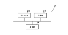
- FIG. 1 is a configuration diagram showing an example of an environmental map management system 1 according to an embodiment of the present invention.
- the environment map management system 1 includes a server 10 and a tracker 12.
- the server 10 and the tracker 12 are connected to a computer network 14 such as the Internet. Then, in the present embodiment, the server 10 and the tracker 12 can communicate with each other.
- the server 10 is, for example, a server computer used by a user of the environment map management system 1.
- the server 10 includes a processor 20, a storage unit 22, and a communication unit 24.
- the processor 20 is, for example, a program control device such as a CPU that operates according to a program installed in the server 10.
- the storage unit 22 is, for example, a storage element such as a ROM or RAM, a hard disk drive, or the like.
- a program or the like executed by the processor 20 is stored in the storage unit 22.
- the communication unit 24 is a communication interface such as a network board or a wireless LAN module.
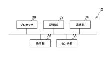
- the tracker 12 is a device that tracks the position and orientation of the user who wears the tracker 12.
- the tracker 12 includes a processor 30, a storage unit 32, a communication unit 34, a display unit 36, and a sensor unit 38.
- the processor 30 is a program control device such as a microprocessor that operates according to a program installed on the tracker 12, for example.
- the storage unit 32 is, for example, a storage element such as a memory. A program or the like executed by the processor 30 is stored in the storage unit 32.
- the communication unit 34 is a communication interface such as a wireless LAN module.
- the display unit 36 is a display arranged in front of the tracker 12, such as a liquid crystal display or an organic EL display.
- the display unit 36 according to the present embodiment can display a three-dimensional image by displaying, for example, an image for the left eye and an image for the right eye.
- the display unit 36 may not be able to display a three-dimensional image and may only display a two-dimensional image.
- the sensor unit 38 is a sensor such as a camera, an inertial sensor (IMU), a geomagnetic sensor (direction sensor), a GPS (Global Positioning System) module, a depth sensor, or the like.
- the camera included in the sensor unit 38 captures an image at a predetermined sampling rate, for example.
- the geomagnetic sensor included in the sensor unit 38 outputs data indicating the direction in which the tracker 12 faces to the processor 30 at a predetermined sampling rate.
- the inertial sensor included in the sensor unit 38 outputs data indicating the acceleration, rotation amount, movement amount, etc. of the tracker 12 to the processor 30 at a predetermined sampling rate.
- the GPS module included in the sensor unit 38 outputs data indicating the latitude and longitude of the tracker 12 to the processor 30 at a predetermined sampling rate.
- the depth sensor included in the sensor unit 38 is, for example, a depth sensor using technologies such as ToF (Time of Flight), Patterned stereo, and Structured Light. The depth sensor outputs data indicating the distance from the tracker 12 to the processor 30 at a predetermined sampling rate.
- the sensor unit 38 may include other sensors such as an RF sensor, an ultrasonic sensor, and an event driven sensor.
- the tracker 12 may include, for example, an HDMI (registered trademark) (High-Definition Multimedia Interface) port, a USB port, an input / output port such as an AUX port, headphones, a speaker, and the like.
- HDMI registered trademark
- AUX AUX Port
- SLAM Simultaneous Localization and Mapping
- self-position estimation for example, at least one of the position and orientation of the tracker 12 is estimated.
- the global position and orientation of the tracker 12 may be estimated.
- the environment map generated in this way is used for various processes such as VR (Virtual Reality) display and AR (Augmented Reality) display.
- the utility value of the environmental map is improved as described below.
- the SLAM processing generates environmental data based on the sensing data acquired by the tracker 12.
- the environmental data is data indicating an object such as a point cloud, a 3D mesh, or a texture, which is generated based on the sensing data by, for example, SLAM processing.
- the environment data generated in this way is accumulated in the server 10 as a part of the life log.
- the environment map at the present time specified by the user is generated based on the environment data stored in the server 10.
- the environment map generated in this way is displayed on the display unit 36 of the tracker 12, for example.
- the storage capacity required to store the environment map becomes enormous. Become.
- the storage capacity required for storing the environment map managed in chronological order can be saved as follows.
- FIG. 3 is a functional block diagram showing an example of the functions implemented by the server 10 and the tracker 12 according to the present embodiment. It is not necessary that all the functions shown in FIG. 3 are implemented in the server 10 and the tracker 12 according to the present embodiment, and functions other than the functions shown in FIG. 3 may be implemented.
- the server 10 includes an element data storage unit 40, a sensing data reception unit 42, a SLAM processing execution unit 44, an element data update unit 46, a recurrent reception unit 48, and a reproduction element.
- a specific unit 50, an environment map reproduction unit 52, and a reproduction environment map transmission unit 54 are included.
- the element data storage unit 40 mainly implements the storage unit 22.
- the sensing data receiving unit 42, the recurrent reception unit 48, and the reproduction environment map transmitting unit 54 are mainly implemented with the communication unit 24.
- the SLAM processing execution unit 44, the element data update unit 46, the reproduction element identification unit 50, and the environment map reproduction unit 52 are mainly implemented with the processor 20.
- the above functions may be implemented by executing a program installed on the server 10 which is a computer and including a command corresponding to the above functions on the processor 20.
- This program may be supplied to the server 10 via a computer-readable information storage medium such as an optical disk, a magnetic disk, a magnetic tape, a magneto-optical disk, or a flash memory, or via the Internet or the like.
- the tracker 12 includes, for example, a sensing data acquisition unit 60, a sensing data transmission unit 62, a recurrent transmission unit 64, a reproduction environment map reception unit 66, and a display control unit 68.
- the sensing data acquisition unit 60 mainly mounts the processor 30 and the sensor unit 38.
- the sensing data transmission unit 62, the recurrent transmission unit 64, and the reproduction environment map reception unit 66 are mainly implemented with the communication unit 34.
- the display control unit 68 mainly mounts the processor 30 and the display unit 36.
- the above functions may be implemented by executing a program installed on the tracker 12 which is a computer and including a command corresponding to the above functions on the processor 30.
- This program may be supplied to the tracker 12 via a computer-readable information storage medium such as an optical disk, a magnetic disk, a magnetic tape, a magneto-optical disk, or a flash memory, or via the Internet or the like.
- the element data storage unit 40 stores, for example, at least one element data.
- the element data according to the present embodiment includes environmental data and sensing time point data.
- the environmental data is, for example, data indicating an object such as a point cloud, a 3D mesh, or a texture, which is generated based on the sensing data by SLAM processing as described above.
- the sensing time point data is data associated with the time point when an element such as an object or a part of the object represented by the environmental data is sensed.
- the representation format of the time point in the sensing time point data is not particularly limited, and is represented by, for example, a date, a date and time, a time, and a time stamp.
- FIG. 4 is a diagram showing an example of a data structure of mesh element data, which is an example of element data according to the present embodiment.
- the mesh element data is data associated with a mesh such as a 3D mesh.
- the mesh element data shown in FIG. 4 includes an element ID, a mesh data, a texture element ID list, sensing time point data, and a child element ID list.
- the element ID included in the mesh element data is the identification information of the mesh element data.
- the mesh data included in the mesh element data is an example of the above-mentioned environmental data, and is data indicating a mesh such as a 3D mesh and the position and orientation in which the mesh is arranged.
- the element ID of the texture element data associated with the mesh element data is set. That is, the texture element ID list is a link to the texture element data associated with the mesh element data. A plurality of element IDs may be set in the texture element ID list.
- the sensing time point data included in the mesh element data includes the occurrence time point data and the disappearance time point data.
- the occurrence time data included in the mesh element data is, for example, data indicating the time when the element represented by the mesh indicated by the mesh data included in the mesh element data is first sensed.
- the disappearance time data included in the mesh element data is, for example, when it is confirmed that the element represented by the mesh indicated by the mesh data included in the mesh element data has disappeared in the real space based on the sensing data. It is the data which shows.
- the disappearance time point data is, for example, data indicating a time point when it is confirmed that the element represented by the mesh has disappeared in the real space based on the latest sensing data.
- the sensing time point data may be data associated with a time range in which the existence of the element in the real space is estimated based on the time point when the element represented by the environmental data is sensed.
- the time range from the time point indicated by the generation time point data included in the mesh element data to the time point indicated by the disappearance time point data corresponds to the time range in which the existence of the element represented by the element data in the real space is estimated.
- values may not be set for at least one of the data at the time of occurrence and the data at the time of disappearance.
- the fact that the extinction time data included in the element data is not set corresponds to the end of the time range in which the existence of the element represented by the element data is estimated in the real space is not set.
- the fact that the occurrence time data included in the element data is not set corresponds to the fact that the start of the time range in which the existence of the element represented by the element data in the real space is estimated is not set.
- the element IDs of other mesh element data associated as child elements of the mesh element data are set.
- a plurality of element IDs may be set in the child element ID list.
- FIG. 5 is a diagram showing an example of a data structure of texture element data, which is another example of element data according to the present embodiment.
- the texture element data is, for example, data associated with a texture attached to a 3D mesh.
- the mesh element data shown in FIG. 5 includes element ID, texture data, and sensing time point data.
- the element ID included in the texture element data is the identification information of the texture element data.
- the texture data included in the texture element data is data indicating the texture to be attached to a mesh such as a 3D mesh.
- the sensing time point data is, for example, data indicating a time point when the texture indicated by the texture data included in the texture element data is sensed.
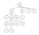
- FIG. 6 is a diagram schematically showing an example of the relationship between the element data according to the present embodiment.
- the elements M1 to M7 shown in FIG. 6 correspond to the mesh element data.
- the elements T1 to T8 shown in FIG. 6 correspond to the texture element data.
- element data having no associated parent element that is, an element in which the element ID of the element data is not set in the child element ID list of any element data stored in the element data storage unit 40.
- the data will be called root element data.
- the element M1 is the root element data.
- the child elements of the element M1 are the element M2 and the element M3. Further, two texture element data (element T1 and element T2) are associated with the element M1. Then, the child elements of the element M2 are the element M4 and the element M5. Further, one texture element data (element T3) is associated with the element M2. One texture element data (element T4) is associated with the element M3. The child elements of element M4 are element M6 and element M7. Further, one texture element data (element T5) is associated with the element M4. One texture element data (element T6) is associated with the element M5. One texture element data (element T7) is associated with the element M6. One texture element data (element T8) is associated with the element M7.
- a plurality of element data are managed by a network structure (for example, a tree structure) in which a plurality of element data are associated with each other.
- the plurality of element data are network structure data arranged on the root side as the time range associated with the sensing time point data included in the element data is longer, and arranged on the leaf side as the time range is shorter. ..
- the sensing data acquisition unit 60 acquires the sensing data generated by the sensor unit 38 of the tracker 12, for example.
- the sensing data acquired by the sensing data acquisition unit 60 may include, for example, an image taken by a camera included in the sensor unit 38 of the tracker 12. Further, the sensing data acquired by the tracker 12 may include the depth data measured by the camera or the depth sensor included in the sensor unit 38 of the tracker 12.
- the sensing data acquired by the tracker 12 may include data indicating the orientation of the tracker 12 measured by the geomagnetic sensor included in the sensor unit 38 of the tracker 12. Further, the sensing data acquired by the tracker 12 may include data indicating the acceleration, rotation amount, movement amount, etc. of the tracker 12 measured by the inertial sensor included in the sensor unit 38.
- the sensing data acquired by the tracker 12 may include data indicating the latitude and longitude of the tracker 12 measured by the GPS module included in the sensor unit 38. Further, the sensing data acquired by the tracker 12 may include a feature point cloud (keyframe).
- the sensing data transmission unit 62 transmits, for example, the sensing data acquired by the sensing data acquisition unit 60 to the server 10.
- sensing data associated with sensing time point data indicating a time point at which sensing by the tracker 12 is performed is transmitted.
- the acquisition and transmission of sensing data in the tracker 12 are repeatedly executed.
- the sensing data receiving unit 42 receives the sensing data transmitted by the tracker 12, for example.
- the SLAM processing execution unit 44 executes SLAM processing including estimation of the position or orientation of the tracker 12 based on the sensing data received by the sensing data receiving unit 42, for example.
- the global position and orientation of the tracker 12 may be estimated.
- the SLAM processing execution unit 44 may execute SLAM processing including relocalization processing, loop closing processing, 3D meshing processing, object recognition processing, and the like.
- the SLAM process may include a plane detection / 3D mesh segmentation process.
- Plane detection / 3D mesh segmentation processing refers to the processing of detecting continuous planes such as the ground and walls and dividing the entire 3D mesh into individual 3D meshes such as the ground, buildings, and trees.
- the SLAM process may include a 3D mesh optimization process.
- the 3D mesh optimization process refers to a process of removing presumed moving objects, dust due to noise, etc., reducing the number of polygons, and smoothing the surface of the mesh from the 3D mesh.
- the SLAM process may include a texture generation process.
- the texture generation process refers to a process of generating a texture image for a 3D mesh based on the colors of the vertices of the mesh.
- the SLAM processing execution unit 44 may store the sensing data received by the sensing data receiving unit 42. Then, the SLAM process may be executed using the time-series sensing data.
- Environmental data such as mesh data and texture data is generated by the above-mentioned SLAM processing executed by the SLAM processing execution unit 44.
- the SLAM processing execution unit 44 may access the element data stored in the element data storage unit 40 and the environment map generated based on the element data when executing the SLAM processing.
- the environmental data based on the new sensing data (the last sensing data received by the server 10) will be referred to as the latest environmental data.
- the element data update unit 46 generates the latest environment map based on a plurality of element data stored in the element data storage unit 40, for example. Then, the element data update unit 46 identifies the difference between a part of the latest environment map and the latest environment data.
- the element data update unit 46 specifies the difference between a part of the latest environment map corresponding to the position of the element appearing in the latest environment data in the real space and the latest environment data.
- the element data update unit 46 represents additional environmental data that is a part or all of the latest environment data and represents an element that does not appear in the latest environment map based on a plurality of element data stored in the element data storage unit 40. To generate.
- the element data update unit 46 specifies, for example, a part of the latest environmental data that represents an element that does not appear in the latest environmental map. If the elements represented by the latest environmental data do not appear in the latest environmental map at all, all of the latest environmental data is specified. Then, the element data update unit 46 generates additional environmental data representing a part or all of the environmental data specified in this way.
- additional environment data There are two types of additional environment data: additional mesh data indicating a mesh and additional texture data indicating a texture.
- the element data update unit 46 generates new element data including the additional environment data generated in this way.
- new element data including additional environment data will be referred to as additional element data.
- new element data including additional mesh data is referred to as additional mesh element data
- new element data including additional texture data is referred to as additional texture element data.
- the element data update unit 46 stores the additional element data in the element data storage unit 40.
- the newly assigned identification information is set in the element ID of the additional mesh element data.
- the additional mesh data is set in the mesh data included in the additional mesh element data.
- the texture element ID of the texture data (for example, additional texture data) indicating the texture of the element represented by the additional mesh data is set.
- the value of the sensing time point data associated with the latest sensing data is set in the value of the occurrence time point data included in the additional mesh element data.
- the element data update unit 46 specifies the mesh element data to which the additional mesh data is associated. For example, the mesh element data of the mesh adjacent to the mesh indicated by the additional mesh data is specified. Then, the element data update unit 46 adds the element ID of the additional mesh element data to the child element ID list of the specified mesh element data. In this way, additional mesh element data is registered as a child element of the specified mesh element data. In this way, the element data update unit 46 associates the additional mesh element data with the specified mesh element data.
- Newly assigned identification information is set in the element ID of the additional texture element data.
- the additional texture data is set in the texture data included in the additional texture element data.
- the value of the sensing time point data associated with the latest sensing data is set in the value of the sensing time point data included in the additional texture element data.
- the element data update unit 46 may specify a mesh to which the texture indicated by the additional texture data is attached. Then, the element ID of the additional texture data may be added to the texture element ID list of the mesh data indicating the mesh.
- the element data update unit 46 identifies an extinguished element that appears in the environmental map but does not appear in the latest environmental data in the latest environmental map. Then, the element data update unit 46 generates the extinction environment data representing the extinction element specified in this way.
- extinction environment data There are two types of extinction environment data: extinction mesh data indicating a mesh and extinction texture data indicating a texture.
- the element data update unit 46 deletes the disappearing element from the element data in which the disappearing element partially appears, for example.
- a part of the mesh data is deleted.
- the element data update unit 46 includes new disappearance environment data and sensing time point data associated with a time range in which the existence of the disappearing element in the real space is estimated based on the time when the disappearing element is sensed. Element data is generated.
- new element data including the extinction environment data will be referred to as extinction element data.
- New element data including the annihilation mesh data will be referred to as annihilation mesh element data.
- new element data including the disappearance texture data will be referred to as disappearance texture element data.
- the element data update unit 46 stores the disappearing element data in the element data storage unit 40.
- Newly assigned identification information is set in the element ID of the disappearance mesh element data.
- the disappearance mesh data is set in the mesh data included in the disappearance mesh element data.
- the texture element ID list included in the disappearance mesh element data the texture element ID of the texture data indicating the texture of the element represented by the disappearance mesh data is set.
- the value of the occurrence time data of the mesh element data in which a part corresponding to the disappearance element is deleted is set as the value of the occurrence time data included in the disappearance mesh element data.
- the mesh element data in which a part corresponding to the disappearing element is deleted is set as the parent element of the disappearing mesh element data.
- the value of the generation time data of the mesh element data which is the parent element of the disappearance mesh element data is set as the value of the generation time data included in the disappearance mesh element data.
- the value of the sensing time point data associated with the latest sensing data is set in the value of the disappearance time point data included in the disappearance mesh element data.
- the element data update unit 46 specifies the mesh element data associated with the disappearance mesh data. For example, the mesh element data in which a part corresponding to the disappearing element is deleted is specified. Then, the element ID of the disappearing mesh element data is added to the child element ID list of the specified mesh element data. In this way, the disappearing mesh element data is registered as a child element of the specified mesh element data.
- Newly assigned identification information is set in the element ID of the disappearing texture element data.
- the disappearance texture data is set in the texture data included in the disappearance texture element data.
- the value of the sensing time point data associated with the latest sensing data is set as the value of the sensing time point data included in the disappearance texture element data.
- the element data update unit 46 may specify a mesh to which the texture indicated by the disappeared texture data is attached. Then, the element ID of the disappearing texture data may be added to the texture element ID list of the mesh data indicating the mesh.
- the element data update unit 46 sets the value of the sensing time point data associated with the latest sensing data to the value of the disappearance time point data included in the element data.
- the time range associated with the sensing time point data included in the element data includes the time range associated with the sensing time point data included in the element data referenced by the link included in the element data. ..
- the time range associated with the sensing time point data included in the mesh element data includes the time range associated with the sensing time point data included in the mesh element data which is a child element of the mesh element data. ..
- the recurrent time transmission unit 64 generates, for example, recurrent time data indicating the recurrent time according to the operation of specifying the recurrent time by the user, and transmits the recurrent time data to the server 10.
- the representation format of the time point in the recurrent data is not particularly limited, and is represented by, for example, a date, a date and time, a time, and a time stamp.
- the re-current time reception unit 48 accepts, for example, the designation of the re-current time, which is the time when the environmental map should be reproduced.
- the recurrent reception unit 48 receives, for example, the recurrent data transmitted from the tracker 12.
- the reproduction element specifying unit 50 identifies, for example, a plurality of element data stored in the element data storage unit 40, including a plurality of sensing time point data associated with a time range including the recurrent time. To do.
- the element data including the sensing time point data associated with the time range including the recurrent time will be referred to as the reproduction element data.
- the mesh element data is the reproduction element data that the re-current time is included between the time point indicated by the occurrence time point data and the time point indicated by the disappearance time point data included in the mesh element data. .. Then, the mesh element data satisfying the condition is specified as the reproduction element data.
- the time point indicated by the occurrence time data is specified as the reproduction element data before the recurrent time.
- the time point indicated by the disappearance time data is specified as the reproduction element data after the re-current time.
- the texture element data that matches the time point indicated by the sensing time point data and the re-current time point is specified.
- the texture element data whose time point indicated by the sensing time point data is closest to the re-current time may be specified.
- the texture element data whose time point indicated by the sensing time point data is closest to the recurrent time may be specified from those whose time point indicated by the sensing time point data is before the recurrent time.
- the environmental map reproduction unit 52 generates an environmental map at the present time again by synthesizing the environmental data included in each of the reproduction element data specified by the reproduction element identification unit 50, for example.
- an environmental map at the time indicated by the recurrent data received from the tracker 12 is generated.
- the environment map generated in this way will be referred to as a reproduction environment map.
- the reproduction environment map transmission unit 54 transmits, for example, the reproduction environment map generated by the environment map reproduction unit 52 to the tracker 12.
- the reproduction environment map generated by the environment map reproduction unit 52 may be transmitted from the position in the environment map corresponding to the position of the tracker 12.
- the reproduction environment map receiving unit 66 receives data such as a reproduction environment map transmitted by the reproduction environment map transmission unit 54, for example.
- the display control unit 68 executes various processes such as VR display and AR display using data such as the reproduction environment map received by the reproduction environment map receiving unit 66.
- the sensing data receiving unit 42 receives the latest sensing data (S101).
- the SLAM processing execution unit 44 executes the SLAM processing based on the sensing data received in the processing shown in S101 (S102).
- the latest environment data is generated by executing the process shown in S102.
- the element data update unit 46 includes the latest environment data generated by the process shown in S102 and a part of the latest environment map generated based on the plurality of element data stored in the element data storage unit 40. , And specify the difference (S103).
- the element data update unit 46 generates the latest environment map by synthesizing a plurality of element data, and specifies the difference between a part of the generated environment map and the latest environment data. May be good.
- the element data update unit 46 generates additional environment data and disappearance environment data based on the specific result in the process shown in S103 (S104).
- the element data update unit 46 selects one of the additional environment data generated in the process shown in S104 that has not been executed in the processes shown in S106 and S107 (S105).
- the element data update unit 46 specifies the element data associated with the additional environment data selected in the process shown in S105 (S106).
- the element data update unit 46 generates additional element data including the additional environment data selected in the process shown in S105, and uses the additional element data as an element associated with the element data specified in the process shown in S106.
- Register (S107) Here, the additional mesh element data is registered as a child element of the element data specified in the process shown in S106.
- the element data update unit 46 confirms whether or not the processes shown in S105 to S107 have been executed for all the additional environment data generated in the process shown in S104 (S108).
- the element data update unit 46 selects one of the disappearance environment data generated in the process shown in S104 that has not been executed in the processes shown in S110 to S114 (S109).
- the element data update unit 46 specifies the element data associated with the disappearance environment data selected in the process shown in S109 (S110).
- the element data update unit 46 determines whether or not the environment data included in the element data specified in the process shown in S110 matches the disappearing environment data selected in the process shown in S109 (S111).
- the element data update unit 46 generates the disappearing element data including the disappearing environment data selected in the process shown in S109, and uses the disappeared element data as an element associated with the element data specified in the process shown in S110.
- Register (S114) Here, the disappearance mesh element data is registered as a child element of the element data specified in the process shown in S110.
- the element data update unit 46 confirms whether or not the processes shown in S109 to S114 have been executed for all the disappearance environment data generated in the process shown in S104 (S115).
- the recurrent reception unit 48 receives the recurrent data transmitted from the tracker 12 (S201).
- the reproduction element specifying unit 50 specifies the mesh indicated by the mesh data included in the root element data (S202).
- the reproduction element specifying unit 50 specifies the texture element data referred to by the texture element ID list included in the root element data, and specifies the texture indicated by the texture data included in the specified texture element data (S203). ..
- the texture element data corresponding to each of the plurality of element IDs is based on the recurrent time indicated by the recurrent time data. One of them is selected. Then, the texture indicated by the texture data included in the selected texture element data is specified.
- the environment map reproduction unit 52 generates a reproduction environment map which is an environment map in which the texture specified by the process shown in S203 is attached to the mesh specified by the process shown in S202 (S204).
- the reproduction element specifying unit 50 specifies the reproduction element data from the mesh element data which is a child element of the root element data (S205).
- the reproduction element specifying unit 50 selects one of the reproduction element data specified in the process shown in S205 that has not been executed the subroutine process shown in FIG. 9 described later (S206).
- reproduction element specifying unit 50 and the environment map reproduction unit 52 execute the subroutine process shown in FIG. 9 with the reproduction element data selected in the process shown in S206 as an argument (S207).
- the reproduction element specifying unit 50 confirms whether or not the subroutine processing shown in FIG. 9 has been executed for all the reproduction element data specified in the process shown in S205 (S208).
- the reproduction environment map transmission unit 54 transmits the reproduction environment map to the tracker 12 (S209), and ends the process shown in this processing example.
- the reproduction element specifying unit 50 specifies the mesh indicated by the mesh data included in the reproduction element data (S301).
- the reproduction element specifying unit 50 specifies the texture element data referred to by the texture element ID list included in the reproduction element data, and specifies the texture indicated by the texture data included in the specified texture element data (S302). ..
- the texture element data corresponding to each of the plurality of element IDs is based on the recurrent time indicated by the recurrent time data. One of them is selected. Then, the texture indicated by the texture data included in the selected texture element data is specified.
- the environment map reproduction unit 52 generates an environment map in which the texture specified by the process shown in S302 is attached to the mesh specified by the process shown in S301, and uses the generated environment map as the reproduction environment map. Add (S303).
- the reproduction element specifying unit 50 confirms whether or not there is a mesh element data that is a child element of the reproduction element data that satisfies the condition of being the reproduction element data (S304).
- the reproduction element specifying unit 50 and the environment map reproduction unit 52 take the child element as an argument for each of the child elements satisfying the condition of being the reproduction element data, as shown in FIG.
- Subroutine processing (S301 to S305) is recursively executed (S305).
- the utility value of the environmental map is improved by making the element data associated with each of the plurality of time points associated with each other as described above.
- the storage capacity required for storing the environment map managed in time series can be saved as compared with the case where the environment map at various time points is stored in time series.
- the reproduction element specifying unit 50 recursively performs a process of specifying the mesh element data which is a child element, in order from the root element data, which satisfies the condition of being the reproduction element data. Execute.
- the time range associated with the sensing time point data included in the element data includes the time range associated with the sensing time point data included in the child element of the element data. Therefore, when it is confirmed that a certain element data does not satisfy the condition of the reproduction element data, it is found that the child element also does not satisfy the condition of the reproduction element data. Therefore, it is not necessary to access the child element. Therefore, the reproduction environment map can be generated without accessing all the element data stored in the element data storage unit 40.
- the sensing time point data included in the texture element data may indicate a time zone such as "morning”, "daytime”, “night”, or the like. Then, when registering the texture element data, a value corresponding to the time zone to which the time point indicated by the sensing time point data associated with the latest sensing data belongs may be set in the sensing time point data. Then, a plurality of texture element data associated with each other in different time zones may be associated with each other by the texture element ID list of the mesh element data.
- the environment map reproduction unit 52 uses the texture element data to display the texture indicated by the texture data associated with the sensing time point data associated with the time zone to which the recurrent time belongs. You may generate a pasted environmental map.
- the texture element data including the sensing time point data associated with the time zone to which the recurrent time belongs is selected from the texture element data referenced by the texture element ID list included in the root element data. You may. Then, the texture indicated by the texture data included in the texture element data may be specified. Then, in the process shown in S204, a reproduced environment map which is an environment map in which the texture specified in this way is attached to the mesh specified in the process shown in S202 may be generated.
- the texture element data including the sensing time point data associated with the time zone to which the recurrent time belongs is selected from the texture element data referred by the texture element ID list included in the root element data. May be done. Then, the texture indicated by the texture data included in the texture element data may be specified. Then, in the process shown in S303, an environment map in which the texture specified in this way is attached to the mesh specified in the process shown in S301 may be added to the reproduced environment map.
- vertex color data indicating the vertex color may be used instead of the texture data.
- the environment map reproduction unit 52 may generate an environment map in which the colors indicated by the vertex color data associated with the reproduction element data are set at the vertices of the mesh indicated by the reproduction element data.
- a plurality of vertex color data associated with each time zone may be associated with the element data indicating the mesh. Then, the environment map reproduction unit 52 sets the color indicated by the vertex color data associated with the reproduction element data and associated with the time zone to which the recurrent time belongs, at the apex of the mesh indicated by the reproduction element data. An environmental map may be generated.
- texture element data according to the present embodiment may be the same data as the mesh element data, which is associated with the time range in which the existence in the real space is estimated.
- the element data at the end (leaf) or the element data having a small number of links with the element data at the end and having a short time range in which the existence in the real space is estimated is the element data. It is highly possible that it is a moving object such as a person. Therefore, such element data may be deleted.
- the number of links between the terminal element data or the element data is a predetermined number or less (for example, 3 or less), and the length of time from the time point indicated by the occurrence time point data to the time point indicated by the extinction time point data is predetermined. Element data shorter than the length of time may be deleted.
- the environment map reproduction unit 52 may generate a four-dimensional environment map including three-dimensional space and time in dimensions based on the environment data corresponding to the sensing data acquired by the tracker. ..
- the environment map reproduction unit 52 may generate a four-dimensional environment map including three-dimensional space and time in dimensions based on a plurality of element data stored in the element data storage unit 40.
- the environment map reproduction unit 52 may generate an environment map for a plurality of recurrent times, and may generate a four-dimensional environment map including the generated plurality of environment maps. Then, the recurrent transmission unit 64 may transmit the generated four-dimensional environment map to the tracker 12.
- the environment map reproduction unit 52 may generate a recurrent environment map received by the recurrent reception unit 48 based on the generated four-dimensional environment map. Then, the recurrent transmission unit 64 may transmit the generated environment map to the tracker 12.
- the newly generated environmental data may not be registered. In this case, the registered environmental data will be used instead of the newly generated environmental data.
- This embodiment can be used, for example, in a scene where an event such as a trip performed at a designated date and time is relived, or a memory is relived at a designated date and time.
- the element data storage unit 40 may also store data indicating the position of the user's viewpoint and the time series in the line-of-sight direction. Then, an environment map of a specific date and time may be generated so that changes in the appearance of the environment map viewed from the viewpoint may be displayed according to the time series of the user's viewpoint and line-of-sight direction at this time. ..
- this embodiment can be used in a scene where the construction process of a specific building is fast-forwarded and reproduced. For example, an environmental map for the same place may be displayed continuously over time.
- the present invention is not limited to the above-described embodiment.
- the division of roles between the server 10 and the tracker 12 is not limited to the above.
- some or all of the functions of the server 10 may be implemented in the tracker 12.
- the tracker 12 may execute the generation of environmental data based on the sensing data. Then, the environment data may be transmitted from the tracker 12 to the server 10.
Landscapes
- Engineering & Computer Science (AREA)
- Physics & Mathematics (AREA)
- Theoretical Computer Science (AREA)
- General Physics & Mathematics (AREA)
- Software Systems (AREA)
- Geometry (AREA)
- Computer Graphics (AREA)
- General Engineering & Computer Science (AREA)
- Databases & Information Systems (AREA)
- Business, Economics & Management (AREA)
- Data Mining & Analysis (AREA)
- Remote Sensing (AREA)
- Tourism & Hospitality (AREA)
- General Health & Medical Sciences (AREA)
- Marketing (AREA)
- Primary Health Care (AREA)
- Strategic Management (AREA)
- General Business, Economics & Management (AREA)
- Architecture (AREA)
- Computer Hardware Design (AREA)
- Human Resources & Organizations (AREA)
- Economics (AREA)
- Health & Medical Sciences (AREA)
- Processing Or Creating Images (AREA)
- Management, Administration, Business Operations System, And Electronic Commerce (AREA)
Abstract
Description
Claims (11)
- トラッカーが取得するセンシングデータに基づいて生成される環境データと、当該環境データが表す要素がセンシングされた時点に基づいて当該要素の実空間における存在が推定される時間範囲に対応付けられるセンシング時点データと、を含む要素データを少なくとも1つ記憶する要素データ記憶部と、
新たなセンシングデータに基づいて生成される環境データに基づいて、当該環境データの一部又は全部である追加環境データが関連付けられる前記要素データを特定する要素データ特定部と、
特定される前記要素データに前記追加環境データを含む前記要素データを関連付ける関連付け部と、
を含むことを特徴とする要素データ管理装置。 - 環境地図を再現すべき時点である再現時点の指定を受け付ける再現時点受付部と、
前記要素データ記憶部に記憶されている複数の前記要素データのうちから、前記再現時点を含む時間範囲に対応付けられる前記センシング時点データを含むものである、再現要素データを複数特定する再現要素特定部と、
特定される複数の前記再現要素データのそれぞれに含まれる前記環境データを合成することで、前記再現時点における環境地図を生成する環境地図再現部と、をさらに含む、
ことを特徴とする請求項1に記載の要素データ管理装置。 - 前記要素データは、他の前記要素データへのリンクを含み、
前記再現要素特定部は、所与のルート要素である前記要素データから順に、当該要素データに含まれる前記リンクにより参照される他の前記要素データのうちから、前記再現時点を含む時間範囲に対応付けられる前記センシング時点データを含むものを特定する処理を再帰的に実行し、
前記環境地図再現部は、再帰的な前記処理の実行によって特定される複数の前記再現要素データのそれぞれに含まれる前記環境データを合成することで、前記再現時点における環境地図を生成する、
ことを特徴とする請求項2に記載の要素データ管理装置。 - 前記要素データに含まれる前記センシング時点データに対応付けられる時間範囲には、当該要素データに含まれるリンクにより参照される前記要素データに含まれる前記センシング時点データに対応付けられる時間範囲が含まれる、
ことを特徴とする請求項3に記載の要素データ管理装置。 - 前記要素データ記憶部に記憶されている複数の要素データは、当該要素データに含まれる前記センシング時点データに対応付けられる時間範囲が長いものであるほどルート側に配置され、短いものであるほどリーフ側に配置されたネットワーク構造のデータである、
ことを特徴とする請求項2に記載の要素データ管理装置。 - メッシュを示す前記要素データには、それぞれ時間帯に対応付けられるテクスチャを示すテクスチャデータが複数関連付けられており、
前記環境地図再現部は、前記再現要素データが示すメッシュに、当該再現要素データに関連付けられている、前記再現時点が属する時間帯に対応付けられる前記テクスチャデータが示すテクスチャが貼られた環境地図を生成する、
ことを特徴とする請求項2から5のいずれか一項に記載の要素データ管理装置。 - メッシュを示す前記要素データには、それぞれ時間帯に対応付けられる頂点色を示す頂点色データが複数関連付けられており、
前記環境地図再現部は、前記再現要素データが示すメッシュの頂点に、当該再現要素データに関連付けられている、前記再現時点が属する時間帯に対応付けられる前記頂点色データが示す色が設定された環境地図を生成する、
ことを特徴とする請求項2から5のいずれか一項に記載の要素データ管理装置。 - 前記要素データ記憶部に記憶されている少なくとも1つの前記要素データに基づく最新の環境地図において、当該環境地図には表れているが前記センシングデータに基づく前記環境データには表れていない消滅要素を特定する消滅要素特定部と、
前記要素データ記憶部に記憶されている、前記消滅要素が一部に表れている前記要素データから当該消滅要素を削除する削除部と、をさらに含み、
前記関連付け部は、前記消滅要素を表す消滅環境データと、前記消滅要素がセンシングされた時点に基づいて当該消滅要素の実空間における存在が推定される時間範囲に対応付けられるセンシング時点データと、を含む新たな前記要素データを生成して、当該新たな要素データを前記消滅要素が一部に表れている前記要素データに関連付ける、
ことを特徴とする請求項1から7のいずれか一項に記載の要素データ管理装置。 - トラッカーが取得するセンシングデータに基づいて生成される環境データと、当該環境データが表す要素がセンシングされた時点に基づいて当該要素の実空間における存在が推定される時間範囲に対応付けられるセンシング時点データと、を含む要素データを少なくとも1つ記憶する要素データ記憶部に記憶されている少なくとも1つの前記要素データのうちから、新たなセンシングデータに基づいて生成される環境データの一部又は全部である追加環境データが関連付けられる前記要素データを特定するステップと、
特定される前記要素データに前記追加環境データを含む前記要素データを関連付けるステップと、
を含むことを特徴とする要素データ管理方法。 - トラッカーが取得するセンシングデータに基づいて生成される環境データと、当該環境データが表す要素がセンシングされた時点に基づいて当該要素の実空間における存在が推定される時間範囲に対応付けられるセンシング時点データと、を含む要素データを少なくとも1つ記憶する要素データ記憶部に記憶されている少なくとも1つの前記要素データのうちから、新たなセンシングデータに基づいて生成される環境データの一部又は全部である追加環境データが関連付けられる前記要素データを特定する手順、
特定される前記要素データに前記追加環境データを含む前記要素データを関連付ける手順、
をコンピュータに実行させることを特徴とするプログラム。 - 要素データのデータ構造であって、
トラッカーによるセンシング結果を示すセンシングデータに基づいて生成される環境データと、
当該環境データが表す要素がセンシングされた時点に基づいて当該要素の実空間における存在が推定される時間範囲に対応付けられるセンシング時点データと、
他の前記要素データへのリンクと、を含み、
前記要素データに含まれる前記センシング時点データに対応付けられる時間範囲には、当該要素データに含まれるリンクにより参照される前記要素データに含まれる前記センシング時点データに対応付けられる時間範囲が含まれる、
ことを特徴とする要素データのデータ構造。
Priority Applications (3)
| Application Number | Priority Date | Filing Date | Title |
|---|---|---|---|
| US17/615,148 US12307591B2 (en) | 2019-06-21 | 2019-06-21 | Element data management apparatus, element data management method, program, and data structure of element data |
| JP2021528627A JP7232909B2 (ja) | 2019-06-21 | 2019-06-21 | 要素データ管理装置、要素データ管理方法、プログラム及び要素データのデータ構造 |
| PCT/JP2019/024817 WO2020255409A1 (ja) | 2019-06-21 | 2019-06-21 | 要素データ管理装置、要素データ管理方法、プログラム及び要素データのデータ構造 |
Applications Claiming Priority (1)
| Application Number | Priority Date | Filing Date | Title |
|---|---|---|---|
| PCT/JP2019/024817 WO2020255409A1 (ja) | 2019-06-21 | 2019-06-21 | 要素データ管理装置、要素データ管理方法、プログラム及び要素データのデータ構造 |
Publications (1)
| Publication Number | Publication Date |
|---|---|
| WO2020255409A1 true WO2020255409A1 (ja) | 2020-12-24 |
Family
ID=74040463
Family Applications (1)
| Application Number | Title | Priority Date | Filing Date |
|---|---|---|---|
| PCT/JP2019/024817 Ceased WO2020255409A1 (ja) | 2019-06-21 | 2019-06-21 | 要素データ管理装置、要素データ管理方法、プログラム及び要素データのデータ構造 |
Country Status (3)
| Country | Link |
|---|---|
| US (1) | US12307591B2 (ja) |
| JP (1) | JP7232909B2 (ja) |
| WO (1) | WO2020255409A1 (ja) |
Families Citing this family (4)
| Publication number | Priority date | Publication date | Assignee | Title |
|---|---|---|---|---|
| US11776218B1 (en) | 2020-10-16 | 2023-10-03 | Splunk Inc. | Networked remote collaboration system |
| US11544904B1 (en) * | 2020-10-16 | 2023-01-03 | Splunk Inc. | Mesh updates in an extended reality environment |
| US11551421B1 (en) | 2020-10-16 | 2023-01-10 | Splunk Inc. | Mesh updates via mesh frustum cutting |
| US11798235B1 (en) | 2020-10-16 | 2023-10-24 | Splunk Inc. | Interactions in networked remote collaboration environments |
Citations (3)
| Publication number | Priority date | Publication date | Assignee | Title |
|---|---|---|---|---|
| JP2009169845A (ja) * | 2008-01-18 | 2009-07-30 | Toyota Motor Corp | 自律移動ロボット及び地図更新方法 |
| JP2018156482A (ja) * | 2017-03-17 | 2018-10-04 | 株式会社東芝 | 移動制御システム、移動制御装置及びプログラム |
| WO2019069524A1 (ja) * | 2017-10-02 | 2019-04-11 | ソニー株式会社 | 環境情報更新装置、環境情報更新方法及びプログラム |
Family Cites Families (6)
| Publication number | Priority date | Publication date | Assignee | Title |
|---|---|---|---|---|
| JP2012248070A (ja) * | 2011-05-30 | 2012-12-13 | Sony Corp | 情報処理装置、メタデータ設定方法、及びプログラム |
| US10429194B2 (en) * | 2016-12-30 | 2019-10-01 | DeepMap Inc. | High definition map updates with vehicle data load balancing |
| US10628686B2 (en) * | 2018-03-12 | 2020-04-21 | Waymo Llc | Neural networks for object detection and characterization |
| US10665028B2 (en) * | 2018-06-04 | 2020-05-26 | Facebook, Inc. | Mobile persistent augmented-reality experiences |
| US11151104B2 (en) * | 2019-05-16 | 2021-10-19 | Microsoft Technology Licensing, Llc | Time systems as data |
| KR102949052B1 (ko) * | 2019-12-20 | 2026-04-07 | 나이앤틱, 스파셜 인크. | 매핑 장치로부터의 로컬 지도 병합 |
-
2019
- 2019-06-21 JP JP2021528627A patent/JP7232909B2/ja active Active
- 2019-06-21 US US17/615,148 patent/US12307591B2/en active Active
- 2019-06-21 WO PCT/JP2019/024817 patent/WO2020255409A1/ja not_active Ceased
Patent Citations (3)
| Publication number | Priority date | Publication date | Assignee | Title |
|---|---|---|---|---|
| JP2009169845A (ja) * | 2008-01-18 | 2009-07-30 | Toyota Motor Corp | 自律移動ロボット及び地図更新方法 |
| JP2018156482A (ja) * | 2017-03-17 | 2018-10-04 | 株式会社東芝 | 移動制御システム、移動制御装置及びプログラム |
| WO2019069524A1 (ja) * | 2017-10-02 | 2019-04-11 | ソニー株式会社 | 環境情報更新装置、環境情報更新方法及びプログラム |
Also Published As
| Publication number | Publication date |
|---|---|
| US12307591B2 (en) | 2025-05-20 |
| JPWO2020255409A1 (ja) | 2021-12-23 |
| JP7232909B2 (ja) | 2023-03-03 |
| US20220237865A1 (en) | 2022-07-28 |
Similar Documents
| Publication | Publication Date | Title |
|---|---|---|
| JP7232909B2 (ja) | 要素データ管理装置、要素データ管理方法、プログラム及び要素データのデータ構造 | |
| KR102417645B1 (ko) | Ar 장면 이미지 처리 방법, 장치, 전자 기기 및 저장 매체 | |
| JP7665839B2 (ja) | Wifi/gpsベースのマップマージを伴うクロスリアリティシステム | |
| EP3649576B1 (en) | Cloud enabled augmented reality | |
| US20250265790A1 (en) | Cross reality system with prioritization of geolocation information for localization | |
| US7535473B2 (en) | Collaborative environments in a graphical information system | |
| JP6094648B2 (ja) | 情報処理システム、情報処理装置、その制御方法、及びプログラム | |
| CN111788606B (zh) | 位置估计装置、位置估计方法和计算机可读存储介质 | |
| CN114175101A (zh) | 用于表面重建即服务的实时反馈 | |
| CN115151948A (zh) | 合并来自建图设备的局部地图 | |
| JP7532539B2 (ja) | 改善された合成および安定した特徴識別情報をサポートする位相的ベースモデル | |
| KR20190089681A (ko) | 파노라마 뷰에 대한 3차원 모델을 생성하는 방법 및 시스템 | |
| KR102314782B1 (ko) | 3차원 증강현실 표시 방법 | |
| US10916066B2 (en) | Methods of virtual model modification | |
| WO2018076372A1 (zh) | 一种航点编辑方法、装置、设备及飞行器 | |
| JP2008230592A (ja) | 解釈型航空機搭載型レーダ・マップの生成の方法およびシステム | |
| JP7495502B2 (ja) | マッピング装置、トラッカー、マッピング方法及びプログラム | |
| KR20240082282A (ko) | 크라우드 소싱 기반 3차원 지도 갱신 방법 및 장치 | |
| WO2023203849A1 (ja) | 空間可視化システム及び空間可視化方法 | |
| US11836420B1 (en) | Constructing a 3D model of a facility based on video streams from cameras at the facility | |
| US11906322B2 (en) | Environment map management device, environment map management system, environment map management method, and program | |
| JP6487545B2 (ja) | 認知度算出装置、認知度算出方法及び認知度算出プログラム | |
| US12306008B2 (en) | Environmental map management apparatus, environmental map management method, and program | |
| KR20230079884A (ko) | 이종 특징들의 통합 최적화 프레임워크를 이용한 영상 처리 방법 및 장치 | |
| WO2021065607A1 (ja) | 情報処理装置および方法、並びにプログラム |
Legal Events
| Date | Code | Title | Description |
|---|---|---|---|
| 121 | Ep: the epo has been informed by wipo that ep was designated in this application |
Ref document number: 19933380 Country of ref document: EP Kind code of ref document: A1 |
|
| ENP | Entry into the national phase |
Ref document number: 2021528627 Country of ref document: JP Kind code of ref document: A |
|
| NENP | Non-entry into the national phase |
Ref country code: DE |
|
| 122 | Ep: pct application non-entry in european phase |
Ref document number: 19933380 Country of ref document: EP Kind code of ref document: A1 |
|
| WWG | Wipo information: grant in national office |
Ref document number: 17615148 Country of ref document: US |