WO2020174649A1 - 情報処理装置、情報処理方法、およびプログラム - Google Patents
情報処理装置、情報処理方法、およびプログラム Download PDFInfo
- Publication number
- WO2020174649A1 WO2020174649A1 PCT/JP2019/007776 JP2019007776W WO2020174649A1 WO 2020174649 A1 WO2020174649 A1 WO 2020174649A1 JP 2019007776 W JP2019007776 W JP 2019007776W WO 2020174649 A1 WO2020174649 A1 WO 2020174649A1
- Authority
- WO
- WIPO (PCT)
- Prior art keywords
- polygon
- area
- information processing
- union
- data
- Prior art date
- Legal status (The legal status is an assumption and is not a legal conclusion. Google has not performed a legal analysis and makes no representation as to the accuracy of the status listed.)
- Ceased
Links
Images







Classifications
-
- G—PHYSICS
- G06—COMPUTING OR CALCULATING; COUNTING
- G06T—IMAGE DATA PROCESSING OR GENERATION, IN GENERAL
- G06T7/00—Image analysis
Definitions
- the embodiment of the present invention relates to an information processing device, an information processing method, and a program.
- the method of processing the map data of the map database is known.
- the conventional technology there are cases where the state of a specific area in the map data cannot be sufficiently grasped.
- the problem to be solved by the present invention is to provide an information processing device, an information processing method, and a program capable of grasping the state of a specific area in map data.
- the information processing apparatus has a data acquisition unit, a data processing unit, and a specific area determination unit.
- the data acquisition unit includes at least a first polygon formed of one or more first lines and a second polygon formed of one or more second lines and included in the area of the first polygon. To obtain statistical data.
- the data processing unit thickens the first line forming the first polygon and the second line forming the second polygon to make the thickened first polygon and the thickened second polygon.
- a first union composed of polygons is generated.
- the specific area determination unit determines, as the specific area, an area of the generated inner ring of the first union that is surrounded by an inner ring that is not included in the area of the second polygon.
- 3 is a flowchart illustrating processing performed by the information processing system according to the first embodiment.
- the flowchart explaining the process performed by the information processing system of 2nd Embodiment The figure which shows the structure of the information processing system of 3rd Embodiment.
- the flowchart explaining the complementary block generation process performed by the information processing system of 3rd Embodiment The figure which shows the structure of the information processing system of 4th Embodiment.
- the flowchart explaining the process performed by the information processing system of 4th Embodiment. The figure which shows the structure of the information processing system of 5th Embodiment.
- the information processing device is realized by one or more processors.
- the information processing device may be a terminal device such as a personal computer, a smartphone, or a tablet terminal that operates at the user's hand, or a cloud server that provides a cloud service.
- the information processing device is a personal computer.
- configurations having the same or similar functions are designated by the same reference numerals. In addition, redundant description of those configurations may be omitted.
- Numerical maps issued by the Geographical Survey Institute which is an example of digital map data, are mainly used for residential areas and urban areas, and include “block data (polygon)”, “house shape data (polygon)”, It includes road data (line), railroad data (line), and water area data (polygon).
- block data polygon
- house shape data polygon
- These data include position information (coordinates) having an accuracy of about 1 m and data (line or polygon) indicating the shape, and attribute data of each polygon or line point (building type, road type, railway type, etc.). Information indicating the land use situation at that coordinate point) is added.
- Digital map data can be used for various machine processing and large-scale data processing. For example, based on the land use classification at each coordinate point on a linear section between certain opposing wireless communication devices, it is possible to grasp the radio wave propagation characteristics of that section mechanically in detail and in large quantities.
- these parts can be uniformly machined as "vacant land”, but as shown in (A) and (B) above, even if the word "vacant land” is used,
- the usage situation is wide-ranging, and for example, it may not be applicable to applications such as mechanically detailed and large-scale estimation of radio wave propagation characteristics according to land use situations.
- the data of representative coordinate points for each town chome exist without omission, but the digital polygon information indicating the area division of that town chome exists only for some residential areas and urban areas. However, this point also hindered mechanical processing.
- the digital map data issued by the Geospatial Information Authority of Japan also has information that directly indicates the land use status itself, but the land use status of the digital map data is not sufficient because of the following situations. is there. (1) The classification of the land use situation is rough and the desired land use situation cannot be obtained. (2) The granularity and resolution of coordinate data are rough at most places. (3) The area is limited, although there are some points with fine grain and resolution. (4) There are many places where information is not provided. (5) The frequency of updating information is low, and there are many places that are far from the actual situation.
- digital map data such as a digital map (basic national land information) issued by the Geographical Survey Institute is provided as vector data.
- vector data all visible features such as topography, rivers, railways, roads, buildings, etc. and invisible things such as administrative circles, vegetation circles, place names, etc. , A point, a line, and a polygon.
- Each of a point, a line, and a polygon has a coordinate and an attribute, and these represent a feature on a map.
- POINT is an arbitrary point on the map.
- the points may be represented by coordinate values (x, y), for example.
- the line is a line segment connecting a plurality of points defined by a plurality of coordinate values (x, y).
- the line may be represented by a combination of a plurality of coordinate values (x, y), for example.
- a polygon is an area closed by a line segment connecting points represented by a plurality of coordinate values (x, y).
- the polygon may be represented by, for example, a combination of a plurality of coordinate values (x, y).
- coordinate values (x, y) expressing points, lines, polygons, etc. for example, latitude/longitude or a value defined by a map projection method can be used.
- Examples of vector data representing digital map data include shape files and GML (Geography Markup Language).
- the vector data is not limited to the above example, and may be in any format as long as it can represent a feature as computer data.
- a union is a new figure created by combining a plurality of figures.
- "generating a union of a plurality of polygons” means generating a new figure (union) created by joining overlapping parts of a plurality of polygons.
- polygons and line segments that make up a union of polygons have a width.
- the outer contour of the polygon or union is called the outer ring
- the inner contour is called the inner ring.
- a plurality of ring-shaped polygons may be formed as an inner ring inside the polygon or the union.
- to thicken a line with a width L means to increase the width of a line to one with a width L/2 and to the other with a width L/2, and thicken a line by a width L in total of one and the other. It is to be.
- thickening a line with a width L means deriving a set of points whose distance from the line is L/2 or less, and the derived set of points is bolded. It is a line.
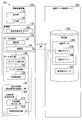
- FIG. 1 is a diagram showing a configuration of an information processing system 10 according to the first embodiment.
- the information processing system 10 includes, for example, an information processing device 100 and a map data providing server 300.
- the information processing apparatus 100 and the map data providing server 300 communicate with each other via a network NW such as the Internet, a WAN (Wide Area Network), or a LAN (Local Area Network).
- NW such as the Internet, a WAN (Wide Area Network), or a LAN (Local Area Network).
- the information processing device 100 includes, for example, a display unit 110, an input unit 120, a storage unit 130, a data acquisition unit 140, a data processing unit 150, and an open space determination unit 190.
- the display unit 110 is, for example, an LCD (Liquid Crystal Display) or the like.
- the display unit 110 displays, for example, the processing result of the open space determination processing of the open space determination unit 190.
- the input unit 120 receives, for example, a user's input (for example, designation of a width L1 described later or designation of map data 360 to be acquired) by operating various keys or buttons.
- the input unit 120 may be configured integrally with the display unit 110 as a touch panel.
- the storage unit 130 is realized by, for example, a storage device including a non-transitory storage medium such as a HDD (Hard Disk Drive) or a flash memory, a RAM (Random Access Memory), a ROM (Read Only Memory), or the like.
- the storage unit 130 stores map data 360 acquired by the communication unit 144 described below.
- the data acquisition unit 140 includes, for example, a reading unit 142 and a communication unit 144.
- the reading unit 142 uses a drive device (not shown) to store the map data 360 recorded in a removable storage medium (non-transitory storage medium) such as a CD-ROM, a DVD-ROM, or a magneto-optical disk. By reading, the map data 360 is acquired and stored in the storage unit 130.
- a removable storage medium non-transitory storage medium
- a magneto-optical disk By reading, the map data 360 is acquired and stored in the storage unit 130.
- the communication unit 144 includes a wireless module for connecting to a cellular network or Wi-Fi network.
- the communication unit 144 communicates with the map data providing server 300 via the network NW, acquires the map data 360, and stores the map data 360 in the storage unit 130, for example.
- the data acquisition unit 140 may include only one of the reading unit 142 and the communication unit 144. Further, the basic map data is read from the recording medium by the reading unit 142 and stored in the storage unit 130, and the difference (update) from the basic map data is acquired by the communication unit 144 via the network NW and stored in the storage unit 130. May be stored.
- the data acquisition unit 140, the data processing unit 150, and the open space determination unit 190 are realized by a hardware processor such as a CPU executing a program (software).
- a hardware processor such as a CPU executing a program (software).
- some or all of these components are hardware (circuits) such as LSI (Large Scale Integration), ASIC (Application Specific Integrated Circuit), FPGA (Field-Programmable Gate Array), GPU (Graphics Processing Unit), etc. Part; including circuitry), or may be realized by cooperation of software and hardware.
- the program may be stored in the storage unit 130 in advance, or may be stored in a removable storage medium (non-transitory storage medium) such as a DVD-ROM or a CD-ROM, and the storage medium is a drive device. It may be installed in the storage unit 130 by being attached to.
- the data processing unit 150 processes the map data 360 acquired by the data acquisition unit 140.
- the data processing unit 150 includes, for example, a polygon thickening unit 152 and a union generation unit 154. These functional units will be described later.
- the map data providing server 300 includes, for example, a storage unit 310.
- the storage unit 310 stores map data 360, for example.
- the map data 360 is digital map data of vector data.
- the map data 360 is, for example, a digital map (national basic information) which is digital map data issued by the Geographical Survey Institute.
- FIG. 2 is a diagram illustrating thickening processing performed by the polygon thickening unit 152 according to the first embodiment.
- the map data 360 includes, for example, a block polygon 370 and a house-shaped polygon 380.
- House-shaped polygon 380 includes house-shaped polygon 380-1, house-shaped polygon 380-2, house-shaped polygon 380-3, and house-shaped polygon 380-4.
- any one of the house-shaped polygons 380-1, 380-2, 380-3, and 380-4 is simply referred to as a house-shaped polygon 380. May be called.
- Each of the block polygon 370 and the house polygon 380 is composed of one or more lines.
- the map data 360 is an example of geographical data.
- the block polygon 370 is an example of a first polygon.
- the house-shaped polygon 380 is an example of a second polygon.
- the polygon thickening unit 152 performs thickening processing.
- the polygon thickening unit 152 for example, thickens the lines forming the block polygon 370 and the house polygon 380 of the map data 360 shown on the left side of FIG.
- the map data 361 shown on the right side of is generated.
- the map data 361 includes a block polygon 370, a block polygon 370A whose line is thicker by width L1 than the house polygon 380, and a house polygon 380A.
- the polygon thickening unit 152 can perform thickening using a general-purpose library. For example, thick line processing can be performed using ST_Buffer defined by OpenGIS (http://www.opengeospatial.org/standards/sfs).
- the width L1 is a tuning parameter, and by adjusting the value of L1 appropriately, it is possible to obtain an inner ring that means a vacant lot.
- the value of L1 can be obtained by trial and error each time according to the map data 360.
- FIG. 3 is a diagram illustrating a union generation process performed by the union generation unit 154 and an inner ring acquisition process performed by the inner ring acquisition unit 156.
- the union generation unit 154 performs a union generation process.
- the union generation unit 154 uses, for example, the map data 361 generated by the thickening process by the polygon thickening unit 152 to generate the city block polygon 370A and the house shape polygon 380A (house shape polygon 380A-1, house shape polygon). 380A-2, house-shaped polygon 380A-3, and house-shaped polygon 380A-4) generate a union 390 which is a polygon in which overlapping portions are combined.
- the union generation unit 154 can perform the union generation process using a general-purpose library.
- Union 390 is an example of a first union.
- the inner ring acquisition unit 156 performs an inner ring acquisition process.
- the inner ring acquisition unit 156 for example, all the inner rings (the inner ring 392, the inner ring 393, the inner ring 394, the inner ring 395) of the union 390 generated by the union generation unit 154. , And the inner ring 396).
- the inner ring acquisition unit 156 can perform the inner ring acquisition process using a general-purpose library.
- the vacant lot determination unit 190 determines the inner ring (inner ring 392, inner ring 393, inner ring 394, inner ring 395, and inner ring 396) obtained in the inner ring acquisition process by the inner ring acquisition unit 156. It is sequentially checked to determine whether each inner ring is included or not included in the house-shaped polygon 380A.
- the inner ring included in the house-shaped polygon 380A means the inside of the building and is not a vacant lot.
- the inner ring that is not included in the house-shaped polygon 380A is a polygon formed in an area having a certain area where there is no building, and thus it can be determined that it is an open-area polygon 400 indicating a vacant land.
- the vacant lot determination unit 190 determines that the inner ring 392 is not included in the area of any house-shaped polygon 380A. Therefore, the open space determination unit 190 determines that the inner ring 392 is an open space, and stores the inner ring 392 in the storage unit 130 as the open space polygon 400.
- the inner ring 393 is included in the area of the house-shaped polygon 380A-1
- the inner ring 394 is included in the area of the house-shaped polygon 380A-2
- the inner ring 395 is included in the area of the house-shaped polygon 380A-3. It is determined that the inner ring 396 is contained in the area of the house-shaped polygon 380A-4.
- the open area determination unit 190 determines that the inner ring 393, the inner ring 394, the inner ring 395, and the inner ring 396 are not open areas.
- the open space determination unit 190 is an example of a specific area determination unit.
- the area surrounded by the open space polygon 400 is an example of the specific area.
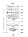
- FIG. 4 is a flowchart illustrating processing performed by the information processing system 10 according to the first embodiment.
- the polygon thickening unit 152 thickens the lines forming the block polygon 370 and the house polygon 380 of the map data 360 with the width L1 (thickening process, step S100).
- the union generation unit 154 generates a union 390 of the block polygon 370 and the house polygon 380 (union generation process, step S110).
- the inner ring acquisition unit 156 obtains all the inner rings (inner ring 392, inner ring 393, inner ring 394, inner ring 395, and inner ring 396) of the union 390 (inner ring acquisition process, step S120). ..
- steps S130 to S170 are executed in a loop.
- the vacant lot determination unit 190 performs vacant lot determination processing to determine whether the inner ring is included in any of the house-shaped polygons 380 (step S144).
- the open area determination unit 190 determines that the inner ring is an open area, and stores the inner ring as the open area polygon 400. It is stored in the unit 130 (step S150).
- the open space determining unit 190 determines that the inner ring is not in the open space (step S160).
- step S170 If it is determined in step S170 that some of the inner rings included in the union 390 have not been processed, the information processing system 10 returns to step S130 and continues the processing. When it is determined in step S170 that processing has been completed for all inner rings included in the union 390, the information processing system 10 ends this flow.
- all the processing (thickening processing, union generation processing, inner ring acquisition processing, vacant land determination processing) performed by the data processing unit 150 and the vacant land determination unit 190 are mechanical. Since it is an algorithm that can be processed according to the above and is a very simple algorithm, it is possible to process enormous data at high speed. Since the processing is performed mechanically, the quality of the generated vacant lot polygons is uniformized.
- FIG. 5 is a figure which shows the structure of 10 A of information processing systems of 2nd Embodiment.
- the information processing system 10A has the same configuration as the information processing system 10 of the first embodiment, but in the information processing device 100A of the information processing system 10A, the data processing unit 150 further includes an inner ring optimization unit 153.
- FIG. 6 is a diagram showing an example of the data processing unit 150 of the information processing system 10A.
- the inner ring (the inner ring 392A to the inner ring 400A) of the union 390A generated by the union generation process by the union generation unit 154 has an angry shape.
- the inner ring optimizing unit 153 performs the inner ring optimizing process on the inner rings 392A to 400A having such an irritating shape, so that the inner ring is appropriately formed into a shape closer to the actual shape of the open space.
- Union 390A is an example of a first union.
- FIG. 7 is a diagram illustrating the inner ring optimization process performed by the inner ring optimization unit 153.
- the inner ring optimization unit 153 first thickens the inner ring 392A to the inner ring 400A with the width L2 to generate the union 390B, and obtains the inner ring 392B of the union 390B.
- the shape of the inner ring 392B of the union 390B obtained by the inner ring optimization unit 153 is a shape in which the abnormally long and narrow portion of the union 390A and the abnormally sharp-edged portion are excluded. This is the effect of thickening the width L2.
- Union 390B is an example of a second union.
- the inner ring optimizing unit 153 thickens the inner ring of the inner ring 392B with a width (L2/2) to obtain the union 390C.
- the outer ring 392C of the union 390C is adopted as the optimized open space polygon 401C. By doing so, the area of the obtained outer ring 392C can be brought close to a value close to the area of the open area polygon 401 before being thickened with the width L2.
- the width L2 is an example of the first width.
- the width L2/2 is an example of the second width.
- Union 390C is an example of a third union.
- FIG. 8 is a flowchart illustrating processing performed by the information processing system 10A of the second embodiment. Steps S100 to S120 are the same as the processing performed by the information processing system 10 of the first embodiment.
- the inner ring optimization process (step S132, step S134, step S136, step S138) is performed before step S144A.
- the polygon thickening unit 152 performs thickening processing to make lines that form the block polygon 370 and the house-shaped polygon 380 (house-shaped polygons 380-1 to 380-4) of the map data 360 wide.
- the line is thickened at L1 (step S100).
- the union generation unit 154 performs union generation processing to generate the union 390A of the block polygon 370 and the house polygon 380 (step S110).
- the inner ring acquisition unit 156 performs an inner ring acquisition process to obtain all the inner rings (inner ring 392A to inner ring 400A) of the union 390A (step S120).
- step S130 to step S170 are executed in a loop for each of all inner rings included in the union 390A.
- the inner ring optimization unit 153 thickens the inner ring (for example, the inner ring 392A in FIGS. 6 and 7) with L2 (step S132).
- the inner ring optimization unit 153 obtains the inner ring (for example, the inner ring 392B of FIGS. 6 and 7) of the thickened inner ring (step S134).
- the inner ring optimization unit 153 thickens the obtained inner ring (for example, the inner ring 392B in FIGS. 6 and 7) with a width L2/2 (step S136).
- the inner ring optimization unit 153 obtains the outer ring of the inner ring thickened with the width L2/2 (for example, the outer ring 392C of FIGS. 6 and 7) (step S138).
- the vacant lot determination unit 190 performs vacant lot determination processing, and determines whether the outer ring obtained by the inner ring optimization unit 153 in step S138 is included in any region of the house-shaped polygon 380 (step S144A). ). If it is determined in step S144A that the outer ring is not contained in any area of the house-shaped polygon 380, the open area determination unit 190 determines that the outer ring is an open area, and stores the outer ring as the open area polygon 400. It is stored in the unit 130 (step S150A). When it is determined in step S144A that the outer ring is included in any area of the house-shaped polygon 380, the open area determination unit 190 determines that the outer ring is not the open area (step S160A).
- step S170 If it is determined in step S170 that some of the inner rings included in the union 390A have not been processed, the information processing system 10A returns to step S130 and continues the processing. When it is determined in step S170 that the processing has been completed for all the inner rings included in the union 390A, the information processing system 10A ends this flow.
- the shape of the obtained open space polygon 400 does not have any jarring, and the shape becomes closer to the actual open space shape.
- the processes (thickening process, union generation process, inner ring acquisition process, inner ring optimization process, open space determination process) performed by the data processing unit 150 and the open space determination unit 190 are all algorithms that can be mechanically processed. Since it can be realized by a combination of the algorithms used in the second embodiment, it is simple and can process a huge amount of data at high speed. Further, since the information processing system 10A performs the processing mechanically, the quality of the generated open space polygon 400 is uniformized.
- FIG. 9 is a diagram showing the configuration of the information processing system 10B of the third embodiment.
- the information processing system 10B has the same configuration as the information processing system 10 of the first embodiment, but the information processing apparatus 100B of the information processing system 10B further includes a complementary block polygon creation unit 145 and is stored in the storage unit 310.
- the generated map data 360A includes, for example, a road/river polygon 450 in addition to the block polygon 370 and the house shape polygon 380.
- the complementary city block polygon creation unit 145 generates a complementary city block polygon 480 from the road/river polygon 450.
- the block polygon 370 is provided only in the urban area.
- the complementary block polygon generation unit 145 generates the complementary block polygons 480 from the road/river polygons 450 that are provided in areas other than the urban area, so that it is possible to generate the open area polygons 400 in areas other than the urban area.
- the complementary block polygon creation unit 145 is an example of a second data processing unit.
- FIG. 10 is a diagram illustrating the complementary block generation processing performed by the complementary block polygon generator 145.
- a block area that means a town street is an area surrounded by one or more of a road, a railroad, a river, and a body of water.
- the complementary block polygon creation unit 145 uses, for example, one of road center line data, railway center line data, river center line data, and water area polygon data included in the map data 360.
- the polygon data (complementary block polygon 480) corresponding to the block polygon 370 is generated as follows.
- the complementary block polygon creation unit 145 thickens all line data, which is included in the map data 360 and forms the road center line, the railway center line, and the river center line, with a width L3. If the line data is thickened, polygon data can be obtained.
- the complementary block polygon creation unit 145 creates road polygons 452A, road polygons 452B, railroad polygons 454, and river polygons 456 by thickening the line data of roads, railways, and rivers.
- the “line represented by the line data forming the road center line, the railway center line, and the river center line” is an example of the third line.
- Each of the road polygon 452A, the road polygon 452B, the railway polygon 454, and the river polygon 456 is an example of the third polygon.
- map data 360 may include roads, railways, rivers, etc. as polygon data instead of line data.
- the complementary block polygon creation unit 145 adopts the polygon data representing the road, railway, and river in the map data 360 as it is as the road polygon 452A, the road polygon 452B, the railroad polygon 454, and the river polygon 456. You can
- the complementary block polygon creation unit 145 obtains the polygon data of each line data obtained by thickening the above and the union of all the water area polygon data. Furthermore, we find all inner rings of the obtained union.
- the obtained inner ring of the union is an area surrounded by at least one of a road, a railroad, a river, and a water area, and therefore becomes polygon data corresponding to a city block polygon. "Polygon data of each line data obtained by thickening and union of all water area polygon data" is an example of the third union.
- the complementary block polygon creation unit 145 checks the overlap between the obtained inner ring of the union and the block polygon 370 included in the map data 360, and the inner ring of the union is outside the block polygon 370. Is a complementary block polygon 480.
- the obtained complementary block polygon 480 can be treated equally as data that approximates a regular block polygon in a place where the block polygon is undeveloped in the map data 360.
- FIG. 11 is a flowchart illustrating the complementary block generation processing performed by the information processing system 10B of the third embodiment.
- the complementary block polygon creation unit 145 acquires the road/river polygon 450 from the map data 360 acquired by the data acquisition unit 140.
- the road/river polygon 450 generates polygon data by thickening all line data, which is included in the road/river polygon 450 and constitutes a road center line, a railway center line, and a river center line, with a width L3 ( Step S200).
- the complementary block polygon creation unit 145 creates a union 390D of polygon data (step S210).
- the complementary block polygon creation unit 145 obtains all the inner rings of the union 390D (step S210).
- step S230 to step S270 are executed in a loop for each of all inner rings included in the union 390D.
- the complementary block polygon creation unit 145 determines whether the inner ring is included in any of the house-shaped polygons 380 (step S240). When it is determined in step S240 that the inner ring is included in any area of the house-shaped polygon 380, the complementary block district polygon creating unit 145 determines that the inner ring is not the complementary block polygon 480 (step S250). ). When it is determined in step S240 that the inner ring is not included in any area of the house-shaped polygon 380, the vacant lot determination unit 190 stores the inner ring in the storage unit 130 as the complementary block polygon 480 (step S260). ..
- step S270 If it is determined in step S270 that some of the inner rings included in the union 390D have not been processed, the information processing system 10B returns to step S230 and continues the processing. When it is determined in step S270 that the processing has been completed for all the inner rings included in the union 390D, the information processing system 10B ends this flow.
- the information processing system 10B of the third embodiment in the numerical map (basic national land information) that is digital map data issued by the Geospatial Information Authority of Japan, blocks other than some urban areas where block polygons are provided. Even in a place where polygons are not provided, the vacant lot determination process can be realized.
- FIG. 12 is a diagram showing the configuration of the information processing system 10C of the fourth embodiment.
- the information processing system 10C has the same configuration as the information processing system 10 of the first embodiment, but the information processing apparatus 100C of the information processing system 10C further includes a land use status determination unit 500, and the storage unit 310 includes:
- the storage unit 310 includes:
- aerial photograph data 455 is stored.
- the storage unit 130 further stores, for example, the aerial photograph determination model 460.
- the land use status determination unit 500 determines the land use status of the open space polygon 400 obtained by the open space determination processing by the open space determination unit 190 based on the aerial photograph data 455 and the aerial photograph determination model 460. Make a decision.
- the aerial photograph data 455 is, for example, data of aerial photographs (for example, aerial photographs and satellite photographs) provided by the Geographical Survey Institute.
- the aerial photograph data 455 includes aerial photograph data of the area corresponding to the map data 360.
- the aerial photograph data 455 is an example of “image data obtained by taking a bird's-eye view of land corresponding to geographical data”.
- the aerial photograph determination model 460 can perform machine learning in advance by using, for example, land use classification as teacher data and aerial photograph data of 128 ⁇ 128 pixels of RGB as input values. It is a trained model that has been built.
- the aerial photograph determination model 460 may be generated in advance by the information processing apparatus 100C and stored in the storage unit 130. Alternatively, the aerial photograph determination model 460 may be generated by another server or computer and transmitted to the information processing device 100C via the network NW.
- the aerial photograph determination model 460 is provided by being recorded in a recording medium.
- the reading unit 142 may read the aerial photograph determination model 460 from the recording medium and store it in the storage unit 130. ..
- the land use status determination unit 500 includes, for example, a rectangular area cutout unit 510 and a photo vacant land determination unit 520.
- FIG. 13 is a diagram illustrating an example of a rectangular area cutout process performed by the rectangular area cutout unit 510.
- the rectangular area cutout unit 510 obtains the minimum value X1 and the maximum value X2 in the longitude direction and the minimum value Y1 and the maximum value Y2 in the latitude direction from the coordinate data forming the open-air polygon 400, respectively.
- a vacant lot determination unit 190 determines a rectangular area 600 that covers the vacant lot polygon 400 determined by the vacant lot determination process. In the obtained rectangular area 600, the lower left coordinates are (X1, Y1) and the upper right coordinates are (X2, Y2).
- Geospatial Information Authority's aerial photographs are provided as tile-shaped data of a certain size, and each tile data contains latitude/longitude information and scale information at the origin in the lower right corner. It is provided.
- the rectangular area cutout unit 510 cuts out the image data of the aerial photograph data 455 of the area corresponding to the rectangular area 600 as the corresponding image data 602.
- the shape of the rectangular area 600 is an example of a “predetermined shape”.
- the rectangular area cutout unit 510 is an example of a “specific area extraction unit”.
- Corresponding image data 602 is an example of “image data corresponding to the area extracted by the specific area extracting unit in the image data”.
- the photo vacant land determination unit 520 uses the aerial photo determination model 460 acquired by the data acquisition unit 140 to determine the land use classification of the corresponding image data 602 cut out by the rectangular area cutout unit 510.
- the land use classification of the corresponding image data 602 is an example of “state of specific area”. Note that, in the present embodiment, the photo vacant land determination unit 520 makes the determination using the learned model constructed by machine learning, but this is an example, and the land use is determined based on image data such as aerial photographs. Other image analysis techniques or analysis methods capable of determining the division may be used.
- FIG. 14 is a flowchart illustrating the processing performed by the information processing system 10C of the fourth embodiment.
- Step S300 is the same as the process shown in the flowchart of FIG. 4 for the first embodiment.
- step S310 to step S350 are executed in a loop for each of all open space polygons 400.
- the rectangular area cutout unit 510 obtains a rectangular area 600 that covers the open area polygon 400 (step S320).
- the rectangular area cutout unit 510 cuts out the image data of the aerial photograph data 455 of the area corresponding to the obtained rectangular area 600 as corresponding image data 602 (step S330).
- the photo vacant land determination unit 520 uses the aerial photo determination model 460 acquired by the data acquisition unit 140 to determine the land use classification of the corresponding image data 602 cut out by the rectangular area cutout unit 510 (step S340). ..
- step S350 If it is determined in step S350 that some of the open space polygons 400 have not been processed yet, the information processing system 10C returns to step S310 and continues processing. When it is determined in step S350 that the processing has been completed for all open space polygons 400, the information processing system 10C ends the present flow.
- the open space polygon 400 is obtained, but also the open space polygon 400 can be subdivided and classified according to the land use classification use of the open space polygon 400. Information can be obtained. Further, according to the information processing system 10C, since the method of cutting out the aerial photograph data 455 is simple, a large amount of processing can be performed at high speed.
- FIG. 15 is a diagram showing the configuration of the information processing system 10D of the fifth embodiment.
- the information processing system 10D has the same configuration as the information processing system 10C of the fifth embodiment, but the information processing apparatus 100D of the information processing system 10D further includes an open space polygon trimming unit 505.
- FIG. 16 is a diagram showing an example of a sub-meshing process in the open space polygon trimming process performed by the open space polygon trimming unit 505.
- the open space polygon 400 obtained by the open space determination unit 190 has various shapes.
- the open space polygon trimming unit 505 generates the submeshed open space polygon 630 by dividing the open space polygon 400 into sub-mesh of a certain size.
- the sub-mesh is assumed to be the simplest square rectangle.
- the size of the sub-mesh is an adjustment parameter. For example, the size of the sub-mesh is about 10 m ⁇ 10 m on the ground.
- the sub-meshed open space polygon 630 is an example of “specific area shape data”.
- the shape of the sub-meshed open space polygon 630 is an example of a “predetermined shape”.
- the open space polygon trimming unit 505 is an example of a “specific area extracting unit”.
- the shape of the sub-meshed open space polygon 630 composed of a plurality of sub-mesh is an example of “a shape formed by connecting a plurality of rectangles so as to be in contact with each other”.
- the sub-mesh is an example of “rectangle”.
- FIG. 17 is a diagram showing an example of sub-meshing compatible image data acquisition processing in the open area polygon trimming processing performed by the open area polygon trimming unit 505.
- the open area polygon trimming unit 505 cuts out the image data of the aerial photograph data 455 of the area corresponding to each sub-mesh as sub-mesh corresponding unit image data for each divided sub mesh.
- the cutout processing is similar to the cutout processing performed by the rectangular area cutout unit 510 of the information processing system 10C according to the fourth embodiment, but the cutout processing performed by the open area polygon trimming unit 505 and the cutout processing performed by the rectangular area cutout unit 510. And, the size of the image data of the aerial photograph data 455 to be cut out is different.
- the air-ground polygon trimming unit 505 cuts out the image data of the aerial photograph data 455 of the area corresponding to all the sub-mesh forming the sub-meshed air-ground polygon 630 as sub-mesh correspondence unit image data, and then acquires the plurality of sub-meshes.
- Sub-mesh corresponding image data 650 is generated by combining the corresponding unit image data according to the arrangement of the original sub-mesh.
- the sub-mesh corresponding image data 650 generated by the open area polygon trimming unit 505 is an aerial photograph trimmed according to the shape of the original open area polygon.
- the sub-mesh corresponding image data 650 is an example of “corresponding area image data”.
- the photo vacant land determination unit 520 uses the aerial photographic determination model 460 acquired by the data acquisition unit 140 to generate the sub-mesh corresponding image generated by the vacant land polygon trimming unit 505.
- the land use classification of the data 650 is determined.
- the land use classification of the sub-mesh corresponding image data 650 is an example of “state of specific area”. Note that, in the present embodiment, the photo vacant land determination unit 520 makes the determination using the learned model constructed by machine learning, but this is an example, and the land use is determined based on image data such as aerial photographs. Other image analysis techniques or analysis methods capable of determining the division may be used.
- FIG. 18 is a flowchart illustrating processing performed by the information processing system 10D according to the fifth embodiment. The same processes as those of the information processing system 10C of the fourth embodiment will be described with the same step numbers.
- Step S300 is the same as the process shown in the flowchart of FIG. 4 for the first embodiment.
- steps S310A to S350A are executed in a loop for each of all open space polygons 400.
- the open space polygon trimming unit 505 divides the open space polygon 400 into sub-mesh of a fixed size to generate a sub-meshed open space polygon 630 (step S320A).
- step S325 to step S333 is executed in a loop for each of all the sub-mesh forming the sub-meshed open space polygon 630.
- the open area polygon trimming unit 505 cuts out the image data of the aerial photograph data 455 of the area corresponding to the sub-mesh as sub-mesh corresponding unit image data and stores it in the storage unit 130 (step S330A).
- step S333 If it is determined in step S333 that there is still a sub-mesh whose processing has not ended, the information processing system 10D returns to step S325 and continues the processing. If it is determined in step S333 that processing has been completed for all sub-meshes, the information processing system 10D proceeds to step S335.
- the open space polygon trimming unit 505 generates the sub-mesh corresponding image data 650 by combining the acquired plurality of sub-mesh corresponding unit image data according to the arrangement of the original sub-mesh (step S335).
- the photo vacant land determination unit 520 uses the aerial photo determination model 460 acquired by the data acquisition unit 140 to determine the land use classification of the sub-mesh corresponding image data 650 cut out by the vacant land polygon trimming unit 505 (step S330A).
- step S350A If it is determined in step S350A that there are still unprocessed open space polygons 400, the information processing system 10D returns to step S310A and continues processing. When it is determined in step S350A that the processing has been completed for all open space polygons 400, the information processing system 10D ends this flow.
- the aerial photograph (corresponding image data 602) used for the determination by the photograph vacant lot determination unit 520 also includes a region other than the vacant lot, so the determination accuracy of the land use classification is sufficiently high. There were times when it wasn't.
- the open space polygon trimming process (sub-meshing process and sub-meshing-compatible image data acquisition process) causes the image data of the aerial photograph data 455 to be closer to the original open space. Since the shape is cut out and the sub-mesh corresponding image data 650 is generated and used for the determination, the determination accuracy of the photo space/ground determination unit 520 is improved.
- the information processing device 100 acquires the map data 360 from the storage unit 310 of the map data providing server 300.
- the map data 360 may be stored in the storage unit 130 of the information processing device 100.
- part or all of the respective processes performed by the information processing device 100, the information processing device 100A, the information processing device 100B, the information processing device 100C, and the information processing device 100D are performed by the map data providing server 300 and other servers. It may be executed, or may be shared and executed with the map data providing server 300 and other servers.
- the open space polygon obtained by the information processing system of the above-described embodiment and modification can be used for prediction of radio wave propagation in wireless communication.
- the communication distance is significantly affected by the presence or absence of an obstacle (or the presence or absence of an open space) in the radio wave propagation path. Therefore, the information processing systems of the embodiment and the modification that facilitate the determination of the presence or absence of an open space can improve the prediction of radio wave propagation in wireless communication.
- the first line forming the first polygon (for example, the city block polygon 370) and the second line forming the second polygon (for example, the house-shaped polygon 380) are thickened,
- a first union (for example, union 390) including a thickened first polygon and a thickened second polygon is generated, and a portion outside the area of the second polygon is generated in the inner ring of the generated first union. Since it is determined that the object is the specific area, it is possible to grasp the state of the specific area in the map data.
Landscapes
- Engineering & Computer Science (AREA)
- Computer Vision & Pattern Recognition (AREA)
- Physics & Mathematics (AREA)
- General Physics & Mathematics (AREA)
- Theoretical Computer Science (AREA)
- Image Analysis (AREA)
- Processing Or Creating Images (AREA)
Abstract
実施形態の情報処理装置は、データ取得部と、データ加工部と、特定領域判定部とを持つ。データ取得部は、1つ以上の第1ラインによって構成される第1ポリゴンと、1つ以上の第2ラインによって構成され第1ポリゴンの領域に包含される第2ポリゴンと、を少なくとも含む地理的データを取得する。データ加工部は、前記第1ポリゴンを構成する前記第1ラインと前記第2ポリゴンを構成する前記第2ラインとを太線化して、前記太線化された第1ポリゴンと前記太線化された第2ポリゴンによって構成される第1ユニオンを生成する。特定領域判定部は、前記生成された第1ユニオンの内環のうち、前記第2ポリゴンの領域に含有されない内環で囲まれる領域を特定領域であると判定する。
Description
本発明の実施形態は、情報処理装置、情報処理方法、およびプログラムに関する。
地図データベースの地図データを加工する方法が知られている。従来の技術では、地図データにおける特定の領域の状態を十分に把握することができない場合があった。
本発明が解決しようとする課題は、地図データにおける特定の領域の状態を把握することができる情報処理装置、情報処理方法、およびプログラムを提供することである。
実施形態の情報処理装置は、データ取得部と、データ加工部と、特定領域判定部とを持つ。データ取得部は、1つ以上の第1ラインによって構成される第1ポリゴンと、1つ以上の第2ラインによって構成され前記第1ポリゴンの領域に包含される第2ポリゴンと、を少なくとも含む地理的データを取得する。データ加工部は、前記第1ポリゴンを構成する前記第1ラインと前記第2ポリゴンを構成する前記第2ラインとを太線化して、前記太線化された第1ポリゴンと前記太線化された第2ポリゴンによって構成される第1ユニオンを生成する。特定領域判定部は、前記生成された第1ユニオンの内環のうち、前記第2ポリゴンの領域に含有されない内環で囲まれる領域を特定領域であると判定する。
以下、実施形態の情報処理装置、情報処理方法、およびプログラムを、図面を参照して説明する。情報処理装置は、一以上のプロセッサにより実現される。情報処理装置は、利用者の手元で動作するパーソナルコンピュータ、スマートフォン、タブレット端末などの端末装置であってもよいし、クラウドサービスを提供するクラウドサーバであってもよい。以下の説明では、情報処理装置はパーソナルコンピュータものとする。以下の説明では、同一または類似の機能を有する構成に同一の符号を付す。そして、それらの構成の重複する説明は省略する場合がある。
まず、実施形態で使用されるデジタル地図データについて説明する。デジタル地図データの一例である、国土地理院が発行する数値地図(国土基本情報)は、主に住宅地や都市部では、「街区データ(ポリゴン)」、「家形データ(ポリゴン)」、「道路データ(ライン)」、「鉄道データ(ライン)」、および「水域データ(ポリゴン)」を含んでいる。これらのデータには、1m程度の精度を有する位置情報(座標)と形状を示すデータ(ラインやポリゴン)に加えて、各ポリゴンやライン点の属性データ(建物種別や道路種別、鉄道種別等、その座標点における土地利用状況を示す情報)が付与されている。
従って、これらのデータの存在する住宅地や都市部については、1m単位で任意の座標点の土地利用状況を機械的に把握することが可能であり、1m単位での土地利用区分を用いた様々な機械処理や大量データ処理にデジタル地図データを使用することができる。例えば、ある対向する無線通信装置間の直線状区間上の各座標点における土地利用区分を元に、その区間の電波伝搬特性を機械的に詳細かつ大量に把握する事が可能である。
ところが、住宅地や都市部などにおける以下の箇所については、土地利用状況を示すデータが存在しない空白地帯となっている。
(A)空き地、駐車場、公園、畑、林など、家形データが存在しない箇所
(B)建物が撤去・新設された後、家形データの更新が間に合っていない箇所
(A)空き地、駐車場、公園、畑、林など、家形データが存在しない箇所
(B)建物が撤去・新設された後、家形データの更新が間に合っていない箇所
これらの箇所は、用途によっては、一律に「空き地」として機械処理することも可能であるが、上記(A)と(B)に示す様に、一言で「空き地」と言っても、土地利用状況は多岐にわたっており、例えば、土地利用状況に応じて電波伝搬特性を機械的に詳細かつ大量に推定する様な用途には適用できないことがあった。
また、街区データについては、町丁目毎の代表座標点のデータは漏れなく存在するものの、その町丁目のエリア区画を示すデジタル・ポリゴン情報は、一部の住宅地や都市部しか存在しておらず、この点も機械処理を妨げるものとなっていた。
また、国土地理院の発行するデジタル地図データには、土地利用状況そのものを直接示す情報も存在するが、以下の様な状況にあるため、デジタル地図データの土地利用状況は、不十分なものである。
(1)土地利用状況を示す分類が荒く、知りたい土地利用状況が得られない。
(2)殆どの箇所は座標データの粒度・分解能が荒い。
(3)粒度・分解能が細かい箇所もあるが、地域が限定されている。
(4)情報が提供されていない箇所も多い。
(5)情報の更新頻度が低く、実態とかい離している箇所も多い。
(1)土地利用状況を示す分類が荒く、知りたい土地利用状況が得られない。
(2)殆どの箇所は座標データの粒度・分解能が荒い。
(3)粒度・分解能が細かい箇所もあるが、地域が限定されている。
(4)情報が提供されていない箇所も多い。
(5)情報の更新頻度が低く、実態とかい離している箇所も多い。
本明細書では、例えば、国土地理院の発行する数値地図(国土基本情報)などのデジタル地図データは、ベクターデータとして提供されているものとする。ベクターデータにおいては、地形、河川、鉄道、道路、建物などの目に見えるものと、行政界、植生界、地名等の目に見えないものとを含めた地上に存在するあらゆる地物が、例えば、ポイント(点)、ライン(線)、およびポリゴン(面)の3つの要素で表現される。ポイントと、ラインと、ポリゴンとのそれぞれが座標と属性を持っており、それらによって地図上において地物を表現する。
ポイントは、地図上における任意の地点である。ポイントは、例えば、座標値(x,y)で表現されてよい。ラインは、複数の座標値(x,y)で定義される複数のポイントを結んだ線分である。ラインは、例えば、複数の座標値(x,y)の組み合わせで表現されてよい。ポリゴンは、複数の座標値(x,y)で表されるポイントを結んだ線分によって閉じられた領域である。ポリゴンは、例えば、複数の座標値(x,y)の組み合わせで表現されてよい。ベクターデータにおいて、ポイント、ライン、ポリゴンなどを表現する座標値(x,y)は、例えば、緯度・経度、あるいは地図投影法により定義された値を用いることができる。デジタル地図データを表現するベクターデータとしては、例えば、シェープファイルやGML(Geography Markup Language)などが挙げられる。しかしながら、ベクターデータは、上記の例に限定されず、コンピューターのデータとして地物を表現できる形式であればどのような形式でもよい。
本明細書では、ユニオンとは、複数の図形を合体させることにより生成された新しい図形のことである。つまり、「複数のポリゴンのユニオンを生成する」とは、複数のポリゴンの相互に重なりあう部分を結合させることにより作られた新しい図形(ユニオン)を生成するという意味である。
本明細書では、ポリゴンや、ポリゴンのユニオンを構成する線分は、幅を持つものとする。幅を持つ線分によって閉じられたポリゴンやユニオンにおいて、そのポリゴンやユニオンの外側の輪郭を外環と呼び、内側の輪郭を内環と呼ぶ。ポリゴンやユニオンの内部に、複数の環状のポリゴンが内環として形成されてもよい。
本明細書では、あるラインを幅Lで太線化するとは、ラインの幅を一方に幅L/2、他方に幅L/2太くして、一方と他方の合計で幅Lだけラインを太線化することである。換言するならば、あるラインを幅Lで太線化するとは、該ラインからの距離が、L/2以下となるポイントの集合を導出することであり、その導出されたポイントの集合が太線化されたラインである。
(第1の実施形態)
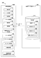
図1は、第1の実施形態の情報処理システム10の構成を示す図である。情報処理システム10は、例えば、情報処理装置100と、地図データ提供サーバ300とを含む。情報処理装置100と、地図データ提供サーバ300とは、例えば、インターネットやWAN(Wide Area Network)、LAN(Local Area Network)等のネットワークNWを介して互いに通信する。
図1は、第1の実施形態の情報処理システム10の構成を示す図である。情報処理システム10は、例えば、情報処理装置100と、地図データ提供サーバ300とを含む。情報処理装置100と、地図データ提供サーバ300とは、例えば、インターネットやWAN(Wide Area Network)、LAN(Local Area Network)等のネットワークNWを介して互いに通信する。
情報処理装置100は、例えば、表示部110、入力部120、記憶部130、データ取得部140、データ加工部150、空地判定部190を含む。
表示部110は、例えば、LCD(Liquid Crystal Display)等である。表示部110は、例えば、空地判定部190の空地判定処理の処理結果を表示する。入力部120は、例えば、各種キーやボタン等の操作によるユーザの入力(例えば後述する幅L1の指定や、取得する地図データ360の指定)を受け付ける。入力部120は、タッチパネルとして表示部110と一体に構成されていてもよい。
記憶部130は、例えば、HDD(Hard Disk Drive)やフラッシュメモリなどの非一過性の記憶媒体を備える記憶装置、RAM(Random Access Memory)、ROM(Read Only Memory)などによって実現される。記憶部130は、後述の通信部144が取得した地図データ360を記憶する。
データ取得部140は、例えば、読取部142と、通信部144とを含む。
読取部142は、例えば、CD-ROM、DVD-ROM、光磁気ディスクなどの着脱可能な記憶媒体(非一過性の記憶媒体)に記録された地図データ360を、ドライブ装置(不図示)によって読み取ることにより、地図データ360を取得し記憶部130に記憶させる。
通信部144は、セルラー網やWi-Fi網と接続するための無線モジュールを含む。通信部144は、例えば、ネットワークNWを介して地図データ提供サーバ300と通信して、地図データ360を取得し、記憶部130に記憶させる。尚、データ取得部140は、読取部142と、通信部144とのうち一方のみ含むものであってもよい。また、基本となる地図データを読取部142によって記録媒体から読み取って記憶部130に記憶させ、基本となる地図データからの差分(アップデート)を通信部144によってネットワークNW経由で取得し記憶部130に記憶させてもよい。
データ取得部140と、データ加工部150と、空地判定部190とは、例えば、CPUなどのハードウェアプロセッサがプログラム(ソフトウェア)を実行することにより実現される。また、これらの構成要素のうち一部または全部は、LSI(Large Scale Integration)やASIC(Application Specific Integrated Circuit)、FPGA(Field-Programmable Gate Array)、GPU(Graphics Processing Unit)などのハードウェア(回路部;circuitryを含む)によって実現されてもよいし、ソフトウェアとハードウェアの協働によって実現されてもよい。プログラムは、予め記憶部130に格納されていてもよいし、DVD-ROMやCD-ROMなどの着脱可能な記憶媒体(非一過性の記憶媒体)に格納されており、記憶媒体がドライブ装置に装着されることで記憶部130にインストールされてもよい。
データ加工部150は、データ取得部140によって取得されたた地図データ360を加工する。データ加工部150は、例えば、ポリゴン太線化部152と、ユニオン生成部154とを含む。これらの機能部については後述する。
地図データ提供サーバ300は、例えば、記憶部310を備える。記憶部310は、例えば、地図データ360を記憶する。地図データ360は、ベクターデータのデジタル地図データである。地図データ360は、例えば、国土地理院が発行するデジタル地図データである数値地図(国土基本情報)である。
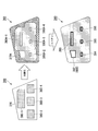
図2は、第1の実施形態のポリゴン太線化部152が行う太線化処理について説明する図である。図示されるように、地図データ360は、例えば、街区ポリゴン370と、家形ポリゴン380とを含む。家形ポリゴン380は、家形ポリゴン380-1、家形ポリゴン380-2、家形ポリゴン380-3、および家形ポリゴン380-4を含む。以下、家形ポリゴン380-1、家形ポリゴン380-2、家形ポリゴン380-3、および家形ポリゴン380-4のうちいずれか1つの任意の家形ポリゴンを、単に、家形ポリゴン380と呼ぶ場合がある。街区ポリゴン370と、家形ポリゴン380とのそれぞれは、1つ以上のラインによって構成される。地図データ360は、地理的データの一例である。街区ポリゴン370は、第1ポリゴンの一例である。家形ポリゴン380は、第2ポリゴンの一例である。
ポリゴン太線化部152は、太線化処理を行う。太線化処理において、ポリゴン太線化部152は、例えば、図2の左側に示される地図データ360の街区ポリゴン370と家形ポリゴン380とを構成するラインを幅L1で太線化することにより、図2の右側に示される地図データ361を生成する。地図データ361は、街区ポリゴン370と、家形ポリゴン380に比べて、ラインが幅L1太くされた街区ポリゴン370Aと、家形ポリゴン380Aを含む。ポリゴン太線化部152は、汎用のライブラリを用いて太線化を行うことができる。例えばOpenGIS(http://www.opengeospatial.org/standards/sfs)が定義するST_Bufferを用いて太線化処理を行うことができる。
幅L1は、チューニングパラメータであり、L1の値を適切に調整することにより、空き地を意味する内環を得ることができる。L1の値は、地図データ360に応じて、都度、試行錯誤して求めることができる。
図3は、ユニオン生成部154が行うユニオン生成処理と、内環取得部156が行う内環取得処理とについて説明する図である。ユニオン生成部154は、ユニオン生成処理を行う。ユニオン生成処理において、ユニオン生成部154は、例えば、ポリゴン太線化部152による太線化処理で生成された地図データ361から、街区ポリゴン370Aと家形ポリゴン380A(家形ポリゴン380A-1、家形ポリゴン380A-2、家形ポリゴン380A-3、および家形ポリゴン380A-4)が相互に重なり合う部分を結合させたポリゴンであるユニオン390を生成する。ユニオン生成部154は、汎用のライブラリを用いてユニオン生成処理を行うことができる。ユニオン390は、第1ユニオンの一例である。
内環取得部156は、内環取得処理を行う。内環取得処理において、内環取得部156は、例えば、ユニオン生成部154によるユニオン生成処理で生成されたユニオン390の全ての内環(内環392、内環393、内環394、内環395、および内環396)を求める。内環取得部156は、汎用のライブラリを用いて内環取得処理を行うことができる。
空地判定部190は、空地判定処理において、内環取得部156による内環取得処理で求められた内環(内環392、内環393、内環394、内環395、および内環396)を順にチェックし、各内環が家形ポリゴン380Aの内部に含まるか含まれないかを判定する。家形ポリゴン380Aの内部に含まれる内環は建物内を意味しており、空き地でない。一方、家形ポリゴン380Aの内部に含まれない内環は、建物の無い一定の面積を持つエリアにできあがったポリゴンとなるので、空き地を示す空地ポリゴン400であると判定できる。
図3の例では、空地判定部190は、内環392は、どの家形ポリゴン380Aの領域にも含有されないと判定する。したがって、空地判定部190は、内環392が空地であると判定し、内環392を空地ポリゴン400として記憶部130に記憶させる。空地判定部190は、内環393は家形ポリゴン380A-1の領域に含有され、内環394は家形ポリゴン380A-2の領域に含有され、内環395は家形ポリゴン380A-3の領域に含有され、内環396は家形ポリゴン380A-4の領域に含有されると判定する。したがって、空地判定部190は、内環393、内環394、内環395、および内環396は、空地ではないと判定する。空地判定部190は、特定領域判定部の一例である。空地ポリゴン400によって囲まれる領域は、特定領域の一例である。
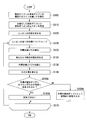
図4は、第1の実施形態の情報処理システム10によって行われる処理を説明するフローチャートである。
まず、ポリゴン太線化部152は、地図データ360の街区ポリゴン370と家形ポリゴン380とを構成するラインを幅L1で太線化する(太線化処理、ステップS100)。次に、ユニオン生成部154は、街区ポリゴン370と家形ポリゴン380とのユニオン390を生成する(ユニオン生成処理、ステップS110)。次に、内環取得部156は、ユニオン390の全ての内環(内環392、内環393、内環394、内環395、および内環396)を求める(内環取得処理、ステップS120)。
次に、ユニオン390に含まれる全ての内環の各々について、ステップS130からステップS170までをループ実行する。ループにおいて、まず、空地判定部190は空地判定処理を行い、内環が家形ポリゴン380のうちいずれかの領域に含有されるか判定する(ステップS144)。ステップS144において、内環が家形ポリゴン380のうちいずれの領域にも含有されないと判定されると、空地判定部190は、内環が空地であると判定し、内環を空地ポリゴン400として記憶部130に記憶させる(ステップS150)。ステップS144において、内環が家形ポリゴン380のうちいずれかの領域に含有されると判定されると、空地判定部190は、内環が空地ではないと判定する(ステップS160)。
ステップS170において、ユニオン390に含まれる内環で処理が終わっていないものがまだあると判定されると、情報処理システム10は、ステップS130に戻って処理を継続する。ステップS170において、ユニオン390に含まれる全ての内環について処理が終わったと判定されると、情報処理システム10は、本フローを終了する。
第1の実施形態の情報処理システム10によれば、データ加工部150と空地判定部190とが行う処理(太線化処理、ユニオン生成処理、内環取得処理、空地判定処理)は、全て機械的に処理できるアルゴリズムであり、且つ、非常にシンプルなアルゴリズムである為、膨大なデータを高速に処理することが可能である。機械的に処理するので、生成される空き地ポリゴンの品質が画一化される。
(第2の実施形態)
次に、第2の実施形態の情報処理システム10Aについて説明する。
図5は、第2の実施形態の情報処理システム10Aの構成を示す図である。情報処理システム10Aは、第1の実施形態の情報処理システム10と同様の構成を有するが、情報処理システム10Aの情報処理装置100Aにおいては、データ加工部150は、内環適正化部153を更に備える。
次に、第2の実施形態の情報処理システム10Aについて説明する。
図5は、第2の実施形態の情報処理システム10Aの構成を示す図である。情報処理システム10Aは、第1の実施形態の情報処理システム10と同様の構成を有するが、情報処理システム10Aの情報処理装置100Aにおいては、データ加工部150は、内環適正化部153を更に備える。
図6は、情報処理システム10Aのデータ加工部150の一例を示す図である。図示されるように、ユニオン生成部154によるユニオン生成処理で生成されたユニオン390Aの内環(内環392A~内環400A)が、イビツな形状となっているものとする。このようなイビツな形状の内環392A~内環400Aに対して、内環適正化部153は、内環適正化処理を行うことにより、内環をより現実の空き地の形状に近い形に適正化する。ユニオン390Aは、第1ユニオンの一例である。
図7は、内環適正化部153の行う内環適正化処理を説明する図である。内環適正化処理において、内環適正化部153は、まず、内環392A~内環400Aを幅L2で太線化してユニオン390Bを生成し、ユニオン390Bの内環392Bを求める。図示されるように、内環適正化部153によって求められたユニオン390Bの内環392Bの形状は、ユニオン390Aの異常に細長い箇所や、異常に鋭角にとがった部分が排除された形状となる。これは幅L2で太線化した効果である。ユニオン390Bは、第2ユニオンの一例である。
ただし、幅L2で太線化された結果、内環392Bの面積が少し狭くなっている。これを元の面積に戻すために、内環適正化処理において、内環適正化部153は、内環392Bの内環を幅(L2÷2)で太線化して、ユニオン390Cを得る。ユニオン390Cの外環392Cを適正化空地ポリゴン401Cとして採用する。こうすることにより、得られた外環392Cの面積を、幅L2で太線化する前の空地ポリゴン401の面積に近い値に近づけることができる。幅L2は、第1幅の一例である。幅L2÷2は、第2幅の一例である。ユニオン390Cは、第3ユニオンの一例である。
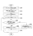
図8は、第2の実施形態の情報処理システム10Aによって行われる処理を説明するフローチャートである。ステップS100からステップS120までは、第1の実施形態の情報処理システム10によって行われる処理と同様である。情報処理システム10Aでは、ステップS130からステップS170のループにおいて、ステップS144Aの前に、内環適正化処理(ステップS132、ステップS134、ステップS136、ステップS138)が行われる。
まず、ポリゴン太線化部152は、太線化処理を行って、地図データ360の街区ポリゴン370と家形ポリゴン380(家形ポリゴン380-1~家形ポリゴン380-4)とを構成するラインを幅L1で太線化する(ステップS100)。次に、ユニオン生成部154は、ユニオン生成処理を行って、街区ポリゴン370と家形ポリゴン380とのユニオン390Aを生成する(ステップS110)。次に、内環取得部156は、内環取得処理を行って、ユニオン390Aの全ての内環(内環392A~内環400A)を求める(ステップS120)。
次に、ユニオン390Aに含まれる全ての内環の各々について、ステップS130からステップS170までをループ実行する。ループにおいて、まず、内環適正化部153は、内環(例えば、図6と図7の内環392A)をL2で太線化する(ステップS132)。次に、内環適正化部153は、太線化された内環の内環(例えば、図6と図7の内環392B)を求める(ステップS134)。 次に、内環適正化部153は、求められた内環(例えば、図6と図7の内環392B)を、幅L2÷2で太線化する(ステップS136)。次に、内環適正化部153は、幅L2÷2で太線化された内環の外環(例えば、図6と図7の外環392C)を求める(ステップS138)。
次に、空地判定部190は空地判定処理を行い、ステップS138で内環適正化部153によって求められた外環が家形ポリゴン380のうちいずれかの領域に含有されるか判定する(ステップS144A)。ステップS144Aにおいて、外環が家形ポリゴン380のうちいずれの領域にも含有されないと判定されると、空地判定部190は、外環が空地であると判定し、外環を空地ポリゴン400として記憶部130に記憶させる(ステップS150A)。ステップS144Aにおいて、外環が家形ポリゴン380のうちいずれかの領域に含有されると判定されると、空地判定部190は、外環が空地ではないと判定する(ステップS160A)。
ステップS170において、ユニオン390Aに含まれる内環で処理が終わっていないものがまだあると判定されると、情報処理システム10Aは、ステップS130に戻って処理を継続する。ステップS170において、ユニオン390Aに含まれる全ての内環について処理が終わったと判定されると、情報処理システム10Aは、本フローを終了する。
第2の実施形態の情報処理システム10Aによれば、得られる空地ポリゴン400の形状にイビツさが無く、より現実の空き地の形状に近い形状となる。また、データ加工部150と空地判定部190とが行う処理(太線化処理、ユニオン生成処理、内環取得処理、内環適正化処理、空地判定処理)は、全て機械的に処理できるアルゴリズムであり、第2の実施形態で用いるアルゴリズムの組み合わせで実現できる為、シンプルであり、膨大なデータを高速に処理することが可能である。また、情報処理システム10Aは、機械的に処理を行うので、生成される空地ポリゴン400の品質が画一化される。
(第3の実施形態)
次に、第3の実施形態の情報処理システム10Bについて説明する。
図9は、第3の実施形態の情報処理システム10Bの構成を示す図である。情報処理システム10Bは、第1の実施形態の情報処理システム10と同様の構成を有するが、情報処理システム10Bの情報処理装置100Bは、補完街区ポリゴン作成部145を更に備え、記憶部310に記憶される地図データ360Aは、例えば、街区ポリゴン370と、家形ポリゴン380とに加えて、道路・河川ポリゴン450を含む。
次に、第3の実施形態の情報処理システム10Bについて説明する。
図9は、第3の実施形態の情報処理システム10Bの構成を示す図である。情報処理システム10Bは、第1の実施形態の情報処理システム10と同様の構成を有するが、情報処理システム10Bの情報処理装置100Bは、補完街区ポリゴン作成部145を更に備え、記憶部310に記憶される地図データ360Aは、例えば、街区ポリゴン370と、家形ポリゴン380とに加えて、道路・河川ポリゴン450を含む。
補完街区ポリゴン作成部145は、道路・河川ポリゴン450から、補完街区ポリゴン480を生成する。例えば、国土地理院が発行するデジタル地図データである数値地図(国土基本情報)では、街区ポリゴン370は、都市部に限って提供されている。補完街区ポリゴン作成部145は、都市部以外でも提供されている道路・河川ポリゴン450から、補完街区ポリゴン480を生成するので、都市部以外でも空地ポリゴン400を生成することを可能にする。補完街区ポリゴン作成部145は、第2データ加工部の一例である。
図10は、補完街区ポリゴン作成部145の行う補完街区生成処理を説明する図である。
一般に、例えば、図10に示されるように、町丁目を意味する街区エリアは、道路と、鉄道と、河川と、水域とのうちいずれか1つ以上によって囲まれたエリアとなる。補完街区ポリゴン作成部145は、この事を利用して、例えば、地図データ360に含まれる、道路中心線データと、鉄道中心線データと、河川中心線データと、水域ポリゴンデータとのうちいずれか1つ以上に基づいて、街区ポリゴン370に相当するポリゴンデータ(補完街区ポリゴン480)を、下記のようにして生成する。
一般に、例えば、図10に示されるように、町丁目を意味する街区エリアは、道路と、鉄道と、河川と、水域とのうちいずれか1つ以上によって囲まれたエリアとなる。補完街区ポリゴン作成部145は、この事を利用して、例えば、地図データ360に含まれる、道路中心線データと、鉄道中心線データと、河川中心線データと、水域ポリゴンデータとのうちいずれか1つ以上に基づいて、街区ポリゴン370に相当するポリゴンデータ(補完街区ポリゴン480)を、下記のようにして生成する。
補完街区ポリゴン作成部145は、まず、地図データ360に含まれる、道路中心線、鉄道中心線、河川中心線を構成する全てのラインデータを幅L3で太線化する。ラインデータを太線化すると、ポリゴンデータを得ることができる。例えば、図10の例では、補完街区ポリゴン作成部145は、道路、鉄道、川のラインデータを太線化することにより、道路ポリゴン452A、道路ポリゴン452B、鉄道ポリゴン454、川ポリゴン456を生成する。「道路中心線、鉄道中心線、河川中心線を構成するラインデータによって表されるライン」は、第3ラインの一例である。道路ポリゴン452Aと、道路ポリゴン452Bと、鉄道ポリゴン454と、川ポリゴン456とのそれぞれは、第3ポリゴンの一例である。
尚、地図データ360は、道路、鉄道、河川などを、ラインデータではなくポリゴンデータとして含んでいてもよい。この場合、補完街区ポリゴン作成部145は、地図データ360における道路、鉄道、河川を表すポリゴンデータを、そのまま、道路ポリゴン452Aと、道路ポリゴン452Bと、鉄道ポリゴン454と、川ポリゴン456として採用することができる。
次に、補完街区ポリゴン作成部145は、上記で太線化して得られた各ラインデータのポリゴンデータおよび、全ての水域ポリゴンデータのユニオンを求める。更に、得られたユニオンの全ての内環を求める。得られたユニオンの内環は、道路と、鉄道と、河川と、水域とのうちいずれか1つ以上によって囲まれたエリアとなるので、街区ポリゴンに相当するポリゴンデータとなる。「太線化して得られた各ラインデータのポリゴンデータおよび、全ての水域ポリゴンデータのユニオン」は、第3ユニオンの一例である。
最後に、補完街区ポリゴン作成部145は、得られたユニオンの内環と、地図データ360に含まれる街区ポリゴン370との重複をチェックし、ユニオンの内環のうち街区ポリゴン370の外部にあるものを補完街区ポリゴン480とする。得られた補完街区ポリゴン480は、地図データ360の中で街区ポリゴンが未整備の場所において、正規の街区ポリゴンを近似するデータとして、同等に扱うことができる。
図11は、第3の実施形態の情報処理システム10Bによって行われる補完街区生成処理を説明するフローチャートである。
まず、補完街区ポリゴン作成部145は、データ取得部140によって取得された地図データ360から道路・河川ポリゴン450を取得する。道路・河川ポリゴン450は、道路・河川ポリゴン450に含まれる、道路中心線、鉄道中心線、河川中心線を構成する全てのラインデータを幅L3で太線化することにより、ポリゴンデータを生成する(ステップS200)。次に、補完街区ポリゴン作成部145は、ポリゴンデータのユニオン390Dを生成する(ステップS210)。次に、補完街区ポリゴン作成部145は、ユニオン390Dの全ての内環を求める(ステップS210)。
次に、ユニオン390Dに含まれる全ての内環の各々について、ステップS230からステップS270までをループ実行する。ループにおいて、まず、補完街区ポリゴン作成部145は、内環が家形ポリゴン380のうちいずれかの領域に含有されるか判定する(ステップS240)。ステップS240において、内環が家形ポリゴン380のうちいずれかの領域に含有されると判定されると、補完街区ポリゴン作成部145は、内環が補完街区ポリゴン480ではないと判定する(ステップS250)。ステップS240において、内環が家形ポリゴン380のうちいずれの領域にも含有されないと判定されると、空地判定部190は、内環を補完街区ポリゴン480として記憶部130に記憶させる(ステップS260)。
ステップS270において、ユニオン390Dに含まれる内環で処理が終わっていないものがまだあると判定されると、情報処理システム10Bは、ステップS230に戻って処理を継続する。ステップS270において、ユニオン390Dに含まれる全ての内環について処理が終わったと判定されると、情報処理システム10Bは、本フローを終了する。
第3の実施形態の情報処理システム10Bによれば、国土地理院が発行するデジタル地図データである数値地図(国土基本情報)において、街区ポリゴンが提供されている一部の都市部以外において、街区ポリゴンが提供されていない場所でも、空地判定処理を実現することができる。
(第4の実施形態)
次に、第4の実施形態の情報処理システム10Cについて説明する。
図12は、第4の実施形態の情報処理システム10Cの構成を示す図である。情報処理システム10Cは、第1の実施形態の情報処理システム10と同様の構成を有するが、情報処理システム10Cの情報処理装置100Cは、土地利用状況判定部500を更に備え、記憶部310は、地図データ360に加えて、例えば、航空写真データ455を記憶する。また、記憶部130は、例えば、航空写真判定モデル460を更に記憶する。
次に、第4の実施形態の情報処理システム10Cについて説明する。
図12は、第4の実施形態の情報処理システム10Cの構成を示す図である。情報処理システム10Cは、第1の実施形態の情報処理システム10と同様の構成を有するが、情報処理システム10Cの情報処理装置100Cは、土地利用状況判定部500を更に備え、記憶部310は、地図データ360に加えて、例えば、航空写真データ455を記憶する。また、記憶部130は、例えば、航空写真判定モデル460を更に記憶する。
情報処理装置100Cにおいては、空地判定部190によって空地判定処理で求められた空地ポリゴン400について、土地利用状況判定部500が、航空写真データ455と航空写真判定モデル460に基づいて、土地利用状況の判定を行う。
航空写真データ455は、例えば、国土地理院が提供する空中写真(例えば航空写真や衛星写真)のデータである。航空写真データ455は、地図データ360に対応する地域の空中写真のデータを含む。航空写真データ455は、「地理的データに対応する土地を俯瞰的に撮像することにより得られた画像データ」の一例である。
例えば、機械学習を適用する場合、航空写真判定モデル460は、例えば、土地利用区分を教師データとして、RGBそれぞれ128×128ピクセルの空中写真のデータを入力値として、事前に械学習を行うことにより構築された学習済みモデルである。航空写真判定モデル460は、あらかじめ情報処理装置100Cで生成されて記憶部130に記憶されていてもよい。または、航空写真判定モデル460は、別のサーバやコンピューターで生成され、ネットワークNWを介して情報処理装置100Cに送信されてもよいし、航空写真判定モデル460は、記録媒体に記録されて提供され、読取部142が記録媒体から航空写真判定モデル460を読取って、記憶部130に記憶させてもよい。
土地利用状況判定部500は、例えば、矩形領域切り出し部510と、写真空地判定部520とを備える。
図13は、矩形領域切り出し部510が行う矩形領域切り出し処理の一例を説明する図である。
矩形領域切り出し部510は、例えば、空地ポリゴン400を構成する座標データの中から、経度方向の最小値X1および最大値X2と、緯度方向の最小値Y1および最大値Y2とをそれぞれ求めることにより、空地判定部190によって空地判定処理で求められた空地ポリゴン400をカバーする矩形領域600を求める。求められた矩形領域600は、左下の座標が(X1,Y1)であり、右上の座標が(X2,Y2)である。
矩形領域切り出し部510は、例えば、空地ポリゴン400を構成する座標データの中から、経度方向の最小値X1および最大値X2と、緯度方向の最小値Y1および最大値Y2とをそれぞれ求めることにより、空地判定部190によって空地判定処理で求められた空地ポリゴン400をカバーする矩形領域600を求める。求められた矩形領域600は、左下の座標が(X1,Y1)であり、右上の座標が(X2,Y2)である。
国土地理院の空中写真(例えば航空写真や衛星写真)は、一定の大きさのタイル形状のデータとして提供されており、各タイルデータには、その右下原点の緯度・経度情報と縮尺情報が提供されている。この情報を元に、矩形領域切り出し部510は、矩形領域600に対応する領域の航空写真データ455の画像データを、対応画像データ602として切り出す。矩形領域600の形状は、「所定形状」の一例である。矩形領域切り出し部510は、「特定領域抽出部」の一例である。対応画像データ602は、「画像データのうち、特定領域抽出部によって抽出された領域に対応する画像データ」の一例である。
写真空地判定部520は、データ取得部140によって取得された航空写真判定モデル460を用いて、矩形領域切り出し部510が切り出した対応画像データ602の土地利用区分を判定する。対応画像データ602の土地利用区分は、「特定領域の状態」の一例である。尚、本実施形態では、写真空地判定部520が、機械学習によって構築された学習済みモデルを用いて判定を行うとしたが、これは一例であり、空中写真などの画像データに基づいて土地利用区分を判定することができる他の画像解析技術や分析手法を用いてもよい。
図14は、第4の実施形態の情報処理システム10Cによって行われる処理を説明するフローチャートである。
まず、データ加工部150が、太線化処理、ユニオン生成処理、および内環取得処理を行い、空地判定部190が、空地判定処理を行って、空地ポリゴン400を生成する(ステップS300)。ステップS300は、第1の実施形態についての図4のフローチャートで示される処理と同様である。
次に、全ての空地ポリゴン400の各々について、ステップS310からステップS350までをループして実行する。ループにおいて、まず、矩形領域切り出し部510は、空地ポリゴン400をカバーする矩形領域600を求める(ステップS320)。矩形領域切り出し部510は、求められた矩形領域600に対応する領域の航空写真データ455の画像データを、対応画像データ602として切り出す(ステップS330)。次に、写真空地判定部520は、データ取得部140によって取得された航空写真判定モデル460を用いて、矩形領域切り出し部510が切り出した対応画像データ602の土地利用区分を判定する(ステップS340)。
ステップS350において、空地ポリゴン400のうちまだ処理が終わっていないものがあると判定されると、情報処理システム10Cは、ステップS310に戻って処理を継続する。ステップS350において、全ての空地ポリゴン400について処理が終わったと判定されると、情報処理システム10Cは、本フローを終了する。
第4の実施形態の情報処理システム10Cによれば、単に空地ポリゴン400を求めるだけでなく、空地ポリゴン400の土地利用区分用途に応じて、空地ポリゴン400を細分化して分類できるので、より高精度な情報取得が可能になる。また、情報処理システム10Cによれば、航空写真データ455を切り出す方法がシンプルであるので、高速で大量な処理が可能である。
(第5の実施形態)
次に、第5の実施形態の情報処理システム10Dについて説明する。
図15は、第5の実施形態の情報処理システム10Dの構成を示す図である。情報処理システム10Dは、第5の実施形態の情報処理システム10Cと同様の構成を有するが、情報処理システム10Dの情報処理装置100Dは、空地ポリゴントリミング部505を更に備える。
次に、第5の実施形態の情報処理システム10Dについて説明する。
図15は、第5の実施形態の情報処理システム10Dの構成を示す図である。情報処理システム10Dは、第5の実施形態の情報処理システム10Cと同様の構成を有するが、情報処理システム10Dの情報処理装置100Dは、空地ポリゴントリミング部505を更に備える。
図16は、空地ポリゴントリミング部505の行う空地ポリゴントリミング処理におけるサブメッシュ化処理の一例を示す図である。図示されるように、空地判定部190によって求められた空地ポリゴン400は、様々な形状である。空地ポリゴントリミング部505は、このような空地ポリゴン400を、一定サイズのサブメッシュに分割することにより、サブメッシュ化空地ポリゴン630を生成する。本実施形態では、サブメッシュは、最も単純である正方形の矩形であるものとする。サブメッシュのサイズは、調整パラメータである。例えば、サブメッシュのサイズは、地上サイズで10m×10m程度である。サブメッシュ化空地ポリゴン630は、「特定領域形状データ」の一例である。サブメッシュ化空地ポリゴン630の形状は、「所定形状」の一例である。空地ポリゴントリミング部505は、「特定領域抽出部」の一例である。複数のサブメッシュによって構成されるサブメッシュ化空地ポリゴン630の形状は、「複数の矩形を互いに接するように繋ぎ合わせた形状」の一例である。サブメッシュは、「矩形」の一例である。
図17は、空地ポリゴントリミング部505の行う空地ポリゴントリミング処理におけるサブメッシュ化対応画像データ取得処理の一例を示す図である。空地ポリゴントリミング部505は、分割したサブメッシュ毎にそのサブメッシュに対応する領域の航空写真データ455の画像データをサブメッシュ対応単位画像データとして切り出す。の切り出し処理は、第4の実施形態の情報処理システム10Cの矩形領域切り出し部510が行う切り出し処理と同様であるが、空地ポリゴントリミング部505の行う切り出しと、矩形領域切り出し部510が行う切り出し処理とでは、切り出す航空写真データ455の画像データのサイズが異なる。空地ポリゴントリミング部505は、サブメッシュ化空地ポリゴン630を構成する全てのサブメッシュに対応する領域の航空写真データ455の画像データをサブメッシュ対応単位画像データとして切り出した後、取得した複数のサブメッシュ対応単位画像データを、元のサブメッシュの配置の通りに結合することにより、サブメッシュ対応画像データ650を生成する。空地ポリゴントリミング部505が生成したサブメッシュ対応画像データ650は、元の空き地ポリゴンの形状に従ってトリミングされた空中写真となる。サブメッシュ対応画像データ650は、「対応領域画像データ」の一例である。
第4の実施形態の情報処理システム10Cと同様に、写真空地判定部520は、データ取得部140によって取得された航空写真判定モデル460を用いて、空地ポリゴントリミング部505が生成したサブメッシュ対応画像データ650の土地利用区分を判定する。サブメッシュ対応画像データ650の土地利用区分は、「特定領域の状態」の一例である。尚、本実施形態では、写真空地判定部520が、機械学習によって構築された学習済みモデルを用いて判定を行うとしたが、これは一例であり、空中写真などの画像データに基づいて土地利用区分を判定することができる他の画像解析技術や分析手法を用いてもよい。
図18は、第5の実施形態の情報処理システム10Dによって行われる処理を説明するフローチャートである。第4の実施形態の情報処理システム10Cと同様な処理には、同じステップ番号を付して説明する。
まず、データ加工部150が、太線化処理、ユニオン生成処理、および内環取得処理を行い、空地判定部190が、空地判定処理を行って、空地ポリゴン400を生成する(ステップS300)。ステップS300は、第1の実施形態についての図4のフローチャートで示される処理と同様である。
次に、全ての空地ポリゴン400の各々について、ステップS310AからステップS350Aまで(第1ループ)をループ実行する。ループにおいて、まず、空地ポリゴントリミング部505は、空地ポリゴン400を、一定サイズのサブメッシュに分割することにより、サブメッシュ化空地ポリゴン630を生成する(ステップS320A)。
次に、サブメッシュ化空地ポリゴン630を構成する全てのサブメッシュの各々について、ステップS325からステップS333まで(第2ループ)をループ実行する。第2ループにおいて、空地ポリゴントリミング部505は、サブメッシュに対応する領域の航空写真データ455の画像データをサブメッシュ対応単位画像データとして切り出して、記憶部130に記憶させる(ステップS330A)。
ステップS333において、処理が終わっていないサブメッシュがまだあると判定されると、情報処理システム10Dは、ステップS325に戻って処理を継続する。ステップS333において、全てのサブメッシュについて処理が終わったと判定されると、情報処理システム10Dは、ステップS335に進む。空地ポリゴントリミング部505は、取得した複数のサブメッシュ対応単位画像データを、元のサブメッシュの配置の通りに結合することにより、サブメッシュ対応画像データ650を生成する(ステップS335)。次に、写真空地判定部520は、データ取得部140によって取得された航空写真判定モデル460を用いて、空地ポリゴントリミング部505が切り出したサブメッシュ対応画像データ650の土地利用区分を判定する(ステップS330A)。
ステップS350Aにおいて、処理が終わっていない空地ポリゴン400がまだあると判定されると、情報処理システム10Dは、ステップS310Aに戻って処理を継続する。ステップS350Aにおいて、全ての空地ポリゴン400について処理が終わったと判定されると、情報処理システム10Dは、本フローを終了する。
第4の実施形態の情報処理システム10Cにおいて、写真空地判定部520が判定に用いる空中写真(対応画像データ602)には、空き地以外の領域も混じる為、土地利用区分の判定精度が十分に高くない場合があった。しかしながら、第5の実施形態の情報処理システム10Dによれば、空地ポリゴントリミング処理(サブメッシュ化処理とサブメッシュ化対応画像データ取得処理)によって、航空写真データ455の画像データから本来の空き地に近い形状が切り出されて、サブメッシュ対応画像データ650が生成され判定に使われるので、写真空地判定部520の判定精度が向上する。
以上、実施形態および変形例について説明した。ただし、実施形態は上記例に限定されない。上述した実施形態では、情報処理装置100は、地図データ360を地図データ提供サーバ300の記憶部310から取得するものとした。しかしながら、地図データ360は、情報処理装置100の記憶部130に記憶されていてもよい。また、情報処理装置100、情報処理装置100A、情報処理装置100B、情報処理装置100C、および情報処理装置100Dによって行われるそれぞれの処理の一部または全部は、地図データ提供サーバ300やその他のサーバで実行されてもよいし、地図データ提供サーバ300やその他のサーバとの間で分担されて実行されてもよい。
上記説明した実施形態および変形例の情報処理システムによって求めた、空地ポリゴンは、無線通信における電波伝搬の予測に利用することができる。無線通信においては、電波伝搬経路における障害物の有無(または空地の有無)によって通信距離が著しく影響を受ける。したがって、空地の有無の判定を容易にする実施形態および変形例の情報処理システムは、無線通信における電波伝搬の予測を向上させることができる。
以上説明した少なくともひとつの実施形態によれば、第1ポリゴン(例えば街区ポリゴン370)を構成する第1ラインと第2ポリゴン(例えば家形ポリゴン380)を構成する第2ラインとを太線化して、太線化された第1ポリゴンと太線化された第2ポリゴンによって構成される第1ユニオン(例えばユニオン390)を生成し、生成された第1ユニオンの内環のうち、第2ポリゴンの領域外のものを特定領域であると判定するので、地図データにおける特定の領域の状態を把握することを可能にする。
本発明のいくつかの実施形態を説明したが、これらの実施形態は、例として提示したものであり、発明の範囲を限定することは意図していない。これら実施形態は、その他の様々な形態で実施されることが可能であり、発明の要旨を逸脱しない範囲で、種々の省略、置き換え、変更を行うことができる。これら実施形態やその変形は、発明の範囲や要旨に含まれると同様に、特許請求の範囲に記載された発明とその均等の範囲に含まれるものである。
10、10A、10B、10C、10D…情報処理システム、100、100A、100B、100C、100D…情報処理装置、145…補完街区ポリゴン作成部、150…データ加工部、152…ポリゴン太線化部、153…内環適正化部、154…ユニオン生成部、156…内環取得部、190…空地判定部、300…地図データ提供サーバ、310…記憶部、500…土地利用状況判定部、505…空地ポリゴントリミング部、510…矩形領域切り出し部、520…写真空地判定部
Claims (12)
- 1つ以上の第1ラインによって構成される第1ポリゴンと、1つ以上の第2ラインによって構成され前記第1ポリゴンの領域に包含される第2ポリゴンと、を少なくとも含む地理的データを取得するデータ取得部と、
前記第1ポリゴンを構成する前記第1ラインと前記第2ポリゴンを構成する前記第2ラインとを太線化して、前記太線化された第1ポリゴンと前記太線化された第2ポリゴンによって構成される第1ユニオンを生成するデータ加工部と、
前記生成された第1ユニオンの内環のうち、前記第2ポリゴンの領域に含有されない内環で囲まれる領域を特定領域であると判定する特定領域判定部と、
を備える情報処理装置。 - 前記データ加工部は、前記太線化された第1ポリゴンと前記太線化された第2ポリゴンとが相互に重なりあう部分を結合させることにより前記第1ユニオンを生成する
請求項1に記載の情報処理装置。 - 前記データ加工部は、前記生成した第1ユニオンの内環を第1幅で太線化して第2ユニオンを生成し、前記生成された第2ユニオンの内環を前記第1幅よりも狭い第2幅で太線化して第3ユニオンを生成し、
前記特定領域判定部は、前記生成された第3ユニオンの外環のうち、前記第2ポリゴンの領域に含有されない外環で囲まれる領域を前記特定領域であると判定する
請求項1または2に記載の情報処理装置。 - 前記データ取得部は、更に、1つ以上の第3ラインと、1つ以上の第4ラインによって構成される第4ポリゴンとのうちいずれか1つ以上を取得し、
前記第3ラインを太線化することにより第3ポリゴンを生成し、前記第3ポリゴンと前記第4ポリゴンのうちいずれか1つ以上によって構成される第3ユニオンを生成する第2データ加工部
を備え、
前記第3ユニオンで囲まれる領域に前記第1ポリゴンが含有される場合、前記特定領域判定部は、前記第3ユニオンの内環で囲まれる領域のうち、前記第2ポリゴンの領域外であるものを前記特定領域であると判定する
請求項1から3のいずれか1項に記載の情報処理装置。 - 前記データ取得部は、更に、前記地理的データに対応する土地を俯瞰的に撮像することにより得られた画像データを取得し、
前記特定領域判定部によって判定された特定領域を包含する、予め設定された所定形状の領域を抽出する特定領域抽出部と、
前記画像データのうち、前記特定領域抽出部によって抽出された領域に対応する画像データに基づいて、前記特定領域の状態を判定する画像判定部と、
を備える請求項1から4のいずれか1項に記載の情報処理装置。 - 前記データ取得部は、更に、領域の状態を教師データとし、画像データを入力データとして、機械学習を行うことにより構築された画像判定モデルを取得し、
前記画像判定部は、前記画像判定モデルに、前記特定領域抽出部によって抽出された領域に対応する画像データを入力することにより、前記特定領域の状態を判定する
請求項5に記載の情報処理装置。 - 前記所定形状は、矩形である
請求項5または6に記載の情報処理装置。 - 前記特定領域抽出部は、前記特定領域を構成する座標の中から、第1方向の最小値と最大値と、前記第1方向と直交する第2方向の最小値と最大値とを抽出し、
前記矩形は、前記第1方向における前記最小値から前記最大値まで延在する線分を一辺とし、前記第2方向における前記最小値から前記最大値まで延在する線分を他の一辺とする矩形である
請求項7に記載の情報処理装置。 - 前記所定形状は、複数の矩形を互いに接するように繋ぎ合わせた形状である
請求項6に記載の情報処理装置。 - 前記特定領域抽出部は、前記特定領域判定部によって判定された特定領域を、前記複数の矩形に分割し、前記分割された特定領域のそれぞれに対応する前記画像データの領域の画像データを取得し、前記所定形状における複数の矩形に従って結合することにより対応領域画像データを生成し、
前記画像判定部とは、前記生成された対応領域画像データに基づいて、前記特定領域の状態を判定する
請求項9に記載の情報処理装置。 - コンピューターが、
1つ以上の第1ラインによって構成される第1ポリゴンと、1つ以上の第2ラインによって構成され前記第1ポリゴンの領域に包含される第2ポリゴンと、を少なくとも含む地理的データを取得し、
前記第1ポリゴンを構成する前記第1ラインと前記第2ポリゴンを構成する前記第2ラインとを太線化して、前記太線化された第1ポリゴンと前記太線化された第2ポリゴンによって構成される第1ユニオンを生成し、
前記生成された第1ユニオンの内環のうち、前記第2ポリゴンの領域に含有されない内環で囲まれる領域を特定領域であると判定する
情報処理装置の情報処理方法。 - コンピューターに、
1つ以上の第1ラインによって構成される第1ポリゴンと、1つ以上の第2ラインによって構成され前記第1ポリゴンの領域に包含される第2ポリゴンと、を少なくとも含む地理的データを取得させ、
前記第1ポリゴンを構成する前記第1ラインと前記第2ポリゴンを構成する前記第2ラインとを太線化させて、前記太線化された第1ポリゴンと前記太線化された第2ポリゴンによって構成される第1ユニオンを生成させ、
前記生成された第1ユニオンの内環のうち、前記第2ポリゴンの領域に含有されない内環で囲まれる領域を特定領域であると判定させる
プログラム。
Priority Applications (2)
| Application Number | Priority Date | Filing Date | Title |
|---|---|---|---|
| PCT/JP2019/007776 WO2020174649A1 (ja) | 2019-02-28 | 2019-02-28 | 情報処理装置、情報処理方法、およびプログラム |
| JP2021501485A JP7143503B2 (ja) | 2019-02-28 | 2019-02-28 | 情報処理装置、情報処理方法、およびプログラム |
Applications Claiming Priority (1)
| Application Number | Priority Date | Filing Date | Title |
|---|---|---|---|
| PCT/JP2019/007776 WO2020174649A1 (ja) | 2019-02-28 | 2019-02-28 | 情報処理装置、情報処理方法、およびプログラム |
Publications (1)
| Publication Number | Publication Date |
|---|---|
| WO2020174649A1 true WO2020174649A1 (ja) | 2020-09-03 |
Family
ID=72238912
Family Applications (1)
| Application Number | Title | Priority Date | Filing Date |
|---|---|---|---|
| PCT/JP2019/007776 Ceased WO2020174649A1 (ja) | 2019-02-28 | 2019-02-28 | 情報処理装置、情報処理方法、およびプログラム |
Country Status (2)
| Country | Link |
|---|---|
| JP (1) | JP7143503B2 (ja) |
| WO (1) | WO2020174649A1 (ja) |
Cited By (1)
| Publication number | Priority date | Publication date | Assignee | Title |
|---|---|---|---|---|
| WO2026023107A1 (ja) * | 2024-07-23 | 2026-01-29 | 三菱電機株式会社 | 学習装置、推論装置、画像生成システム、変化検出システム、画像生成方法、及び画像生成プログラム |
Citations (2)
| Publication number | Priority date | Publication date | Assignee | Title |
|---|---|---|---|---|
| JP2000337894A (ja) * | 1999-05-24 | 2000-12-08 | Fujitsu Ten Ltd | ナビゲーション装置における市街図有無判定方法及び装置及び地図データ記憶 |
| JP2003186390A (ja) * | 2001-08-14 | 2003-07-04 | Navigation Technol Corp | 地理的特徴を表す多角形の重なり部分及び和集合を求める方法 |
-
2019
- 2019-02-28 JP JP2021501485A patent/JP7143503B2/ja active Active
- 2019-02-28 WO PCT/JP2019/007776 patent/WO2020174649A1/ja not_active Ceased
Patent Citations (2)
| Publication number | Priority date | Publication date | Assignee | Title |
|---|---|---|---|---|
| JP2000337894A (ja) * | 1999-05-24 | 2000-12-08 | Fujitsu Ten Ltd | ナビゲーション装置における市街図有無判定方法及び装置及び地図データ記憶 |
| JP2003186390A (ja) * | 2001-08-14 | 2003-07-04 | Navigation Technol Corp | 地理的特徴を表す多角形の重なり部分及び和集合を求める方法 |
Non-Patent Citations (1)
| Title |
|---|
| HONDA KEIICHI ET AL.: "Computer generation of 3-D scenery image based on paper map and aerial pictures", ITE TECHNICAL REPORT, vol. 24, no. 23, 2000, pages 15 - 19 * |
Cited By (1)
| Publication number | Priority date | Publication date | Assignee | Title |
|---|---|---|---|---|
| WO2026023107A1 (ja) * | 2024-07-23 | 2026-01-29 | 三菱電機株式会社 | 学習装置、推論装置、画像生成システム、変化検出システム、画像生成方法、及び画像生成プログラム |
Also Published As
| Publication number | Publication date |
|---|---|
| JP7143503B2 (ja) | 2022-09-28 |
| JPWO2020174649A1 (ja) | 2021-10-28 |
Similar Documents
| Publication | Publication Date | Title |
|---|---|---|
| Albert et al. | Modeling urbanization patterns with generative adversarial networks | |
| US20190130427A1 (en) | Candidate site evaluation system and candidate site evaluation method | |
| US11468999B2 (en) | Systems and methods for implementing density variation (DENSVAR) clustering algorithms | |
| CN111985355A (zh) | 基于深度学习和云计算的遥感建筑物震害评估方法和系统 | |
| US20200380742A1 (en) | Systems and methods for generating road map | |
| CN110428386B (zh) | 地图网格合并方法、装置、存储介质、电子装置 | |
| WO2019225597A1 (ja) | 空き家判定装置、空き家判定方法、記録媒体 | |
| CN112417070B (zh) | 路网拓扑构建方法、装置、电子设备及存储介质 | |
| Crişan et al. | Emergency management using geographic information systems: application to the first romanian traveling salesman problem instance | |
| CN111080080A (zh) | 一种村镇地质灾害风险预估方法及系统 | |
| Kumar et al. | Geographic information systems in urban planning and management | |
| Rambu Ngana et al. | Scenario modelling as planning evidence to improve access to emergency obstetric care in eastern Indonesia | |
| CN112700073B (zh) | 公交线路规划方法和装置 | |
| WO2020174649A1 (ja) | 情報処理装置、情報処理方法、およびプログラム | |
| Sharma et al. | Development of ‘3D city models’ using IRS satellite data | |
| Galton et al. | Anchoring: A new approach to handling indeterminate location in GIS | |
| US10452733B2 (en) | Semantic location and proximity of maps | |
| Mathioulakis et al. | Using the sleuth model to simulate future urban growth in the greater Eastern Attica area, Greece | |
| CN117251438A (zh) | 基于WebGIS的多源数据管理方法及云端共享系统 | |
| Arzoumanidis et al. | Towards a Deep Automatic Generation of Figure-ground Maps | |
| Kazemi et al. | Deriving multi‐scale GEODATA from TOPO‐250K road network Data | |
| Duchêne | Making a map from thematically multi-sourced data: the potential of making inter-layers spatial relations explicit | |
| Ferretti et al. | A spatial decision support tool to study risks and opportunities of complex environmental systems | |
| US12461951B1 (en) | Parcel growth model training system | |
| US20240104676A1 (en) | Artificial intelligence-based parcel graph model generation |
Legal Events
| Date | Code | Title | Description |
|---|---|---|---|
| 121 | Ep: the epo has been informed by wipo that ep was designated in this application |
Ref document number: 19916718 Country of ref document: EP Kind code of ref document: A1 |
|
| ENP | Entry into the national phase |
Ref document number: 2021501485 Country of ref document: JP Kind code of ref document: A |
|
| NENP | Non-entry into the national phase |
Ref country code: DE |
|
| 122 | Ep: pct application non-entry in european phase |
Ref document number: 19916718 Country of ref document: EP Kind code of ref document: A1 |