US8849942B1 - Application programming interface for prefetching map data - Google Patents
Application programming interface for prefetching map data Download PDFInfo
- Publication number
- US8849942B1 US8849942B1 US13/590,931 US201213590931A US8849942B1 US 8849942 B1 US8849942 B1 US 8849942B1 US 201213590931 A US201213590931 A US 201213590931A US 8849942 B1 US8849942 B1 US 8849942B1
- Authority
- US
- United States
- Prior art keywords
- map data
- api
- map
- software application
- geographic area
- Prior art date
- Legal status (The legal status is an assumption and is not a legal conclusion. Google has not performed a legal analysis and makes no representation as to the accuracy of the status listed.)
- Active, expires
Links
Images




Classifications
-
- G—PHYSICS
- G06—COMPUTING OR CALCULATING; COUNTING
- G06F—ELECTRIC DIGITAL DATA PROCESSING
- G06F12/00—Accessing, addressing or allocating within memory systems or architectures
- G06F12/02—Addressing or allocation; Relocation
- G06F12/08—Addressing or allocation; Relocation in hierarchically structured memory systems, e.g. virtual memory systems
- G06F12/0802—Addressing of a memory level in which the access to the desired data or data block requires associative addressing means, e.g. caches
- G06F12/0862—Addressing of a memory level in which the access to the desired data or data block requires associative addressing means, e.g. caches with prefetch
-
- G—PHYSICS
- G06—COMPUTING OR CALCULATING; COUNTING
- G06F—ELECTRIC DIGITAL DATA PROCESSING
- G06F16/00—Information retrieval; Database structures therefor; File system structures therefor
- G06F16/20—Information retrieval; Database structures therefor; File system structures therefor of structured data, e.g. relational data
- G06F16/29—Geographical information databases
-
- G—PHYSICS
- G09—EDUCATION; CRYPTOGRAPHY; DISPLAY; ADVERTISING; SEALS
- G09B—EDUCATIONAL OR DEMONSTRATION APPLIANCES; APPLIANCES FOR TEACHING, OR COMMUNICATING WITH, THE BLIND, DEAF OR MUTE; MODELS; PLANETARIA; GLOBES; MAPS; DIAGRAMS
- G09B29/00—Maps; Plans; Charts; Diagrams, e.g. route diagram
- G09B29/10—Map spot or coordinate position indicators; Map reading aids
- G09B29/106—Map spot or coordinate position indicators; Map reading aids using electronic means
Definitions
- the present disclosure relates to digital maps and, more particularly, to an application programming interface (API) for prefetching map data on a computing device.
- API application programming interface
- mapping and navigation applications are developed primarily for displaying interactive digital maps.
- Other software applications such as web browsers, may display interactive digital maps along with other content.
- a software application To display an interactive digital map, a software application usually requests map data from a map data provider for a particular geographic area.
- a software application executing on a portable device typically requests map data from the map data provider via a wireless communication network in which the portable device operates.
- the software application can only receive map data when the portable device has wireless network coverage that supports a data connection.
- the software application often cannot display a map of the area in which the portable device is located, for example.
- One embodiment of the techniques discussed below is a computer-readable medium storing instructions that implement an API for prefetching map data.
- the map data is prefetched on a computing device having a processor and a display device and configured to communicate with a map data provider via a communication network.
- the API When invoked in a software application executed on the processor, the API is configured to receive a prefetch request for an indicated geographic area from the software application.
- the API In response to the prefetch request, the API is configured to retrieve map data corresponding to the indicated geographic area from the map data provider and store the map data in a map data cache without causing a map image based on the map data to be displayed on the display device, where the map data cache is accessible to the software application only via the API.
- the API is further configured to, subsequently to storing the map data in the map data cache, receive a request to render the map image from the software application and, in response to the request to render the map image, render the map image using the map data stored in the map data cache, where the map image is displayed on the display device.
- Another embodiment of these techniques is a method for prefetching map data in computing device including a memory, a processor, and a display device.
- the method includes allocating a portion of the memory for use as a map data cache that stores map data received from a map data provider via a communication network, and preventing software applications being executed by the processor from accessing the map data cache.
- the method further includes providing an API for use by the software applications.
- the method includes retrieving map data for an indicated geographic area and storing the map data in the map data cache, where a map image based on the map data is not displayed on the display device in response to the API being invoked for prefetching the map data.
- the method includes retrieving the map data from the map data cache and generating a map image using the map data for display on the display device.
- a mobile device is configured to communicate via a wireless communication link and includes a processor, a display device, a network interface communicatively coupled to the wireless communication link, a memory communicatively coupled to the processor, a map data cache disposed in the memory, and instructions stored in the memory that implement an API for prefetching map data.
- the map data cache is not accessible to software applications executing on the mobile device via read or write operations.
- the API when invoked by a software application executing on the mobile device, is configured to, in response to receiving a prefetch request indicating a geographic area from a software application executing on the mobile device, retrieve map data for the indicated geographic area via the network interface and store the map data in the map data cache, where a map image based on the map data is not displayed on the display device in response to receiving the prefetch request.
- the API is configured to cause the map image to be displayed on the display device using the map data stored in the map data cache.
- FIG. 1 is a block diagram of an example communication system in which a software application executing on a portable device invokes an API to prefetch map data from a map data provider;
- FIG. 2 is a block diagram of an example portable device of FIG. 1 ;
- FIG. 3 is a diagram that illustrates prefetching map tiles through which a polyline, supplied to the API of FIG. 1 as a parameter, passes;
- FIG. 4 is a diagram that illustrates prefetching map tiles within a certain radius of the polyline of FIG. 3 ;
- FIG. 5 is a diagram that illustrates prefetching map elements in a vector format within a certain radius of a polyline supplied to the API of FIG. 1 as a parameter;
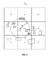
- FIG. 6 schematically illustrates prefetching map elements in a vector format within a certain radius of a point supplied to the API of FIG. 1 as a parameter;
- FIG. 7 is a flow diagram of an example method for providing map data prefetching capability to software applications executing on the portable device of FIG. 1 ;
- FIG. 8 is a flow diagram of an example method for prefetching map data in the portable device of FIG. 1 .
- An Application Programming Interface allows software applications to prefetch map data for a geographic area in advance of a user request or an automated decision to display a digital map image (for simplicity, a “digital map”) of the geographic area.
- a software application invokes the API to specify a polyline or a point, and the API retrieves map data for a geographic area within a certain radius of the polyline or point from a map data provider.
- the API stores the received map data in a map data cache over which the API has exclusive control, so that a software application that invokes the API cannot access the map data cache directly.
- the software application can access the map data cache only via calls to the API.
- the API may control the level of detail of the prefetched map data.
- the software application invokes the API to display a digital map of the geographic area, and the API renders the digital map using the stored map data without requesting the map data from the map data provider.
- FIG. 1 illustrates an example communication system 10 in which a portable device 12 receives map data from a map data provider 14 via a wireless communication network 16 .
- the map data provider 14 in this implementation is a server that communicates with a map database 18 .
- a software application 20 may invoke an API 22 for prefetching and rendering map data in anticipation of losing network coverage, or when the cost of a network connection is expected to rise, for example. More generally, the software application 20 may prefetch map data using the API 22 when there is a significant probability (or certainty) that the map data will be needed at the portable device 12 at a later time, and when the present conditions for receiving data are better than the expected conditions at the later time.
- the software application 20 requests and receives map data from the map data provider 14 on demand.
- the software application 20 may be a mapping application, and a user may request a digital map for a specified location (e.g., “San Francisco, Calif.”).
- the software application 20 generates and transmits a request for map data corresponding to the specified location upon receiving the user request.
- the map data server 14 in response provides the requested map data, and the software application 20 renders and displays a digital map for the specified location.
- the software application 20 may be a navigation application configured to display a digital map for the current location of the portable device 12 .
- the software application 20 automatically generates a request for map data corresponding to this new location.
- the software application 20 may determine that the portable device 12 will soon leave the area of coverage of the wireless communication network 16 , or that the portable device 12 will roam to a wireless network that offers a significantly slower or a significantly more expensive data connection. If the software application 20 or the user can anticipate for which locations map data will be needed, the software application 20 can invoke the API 22 to prefetch map data for some of all of these anticipated locations. In some embodiments, the software application 20 is configured to automatically prefetch map data only if the user explicitly configures the software application 20 to do so, particularly if the software application 20 uses the user's profile to determine which map data should be prefetched. In other embodiments, the software application 20 automatically prefetches map data without the user's explicit configuration, but in any case with user's consent and in accordance with relevant privacy policies.
- the software application 20 may respond to various events or “signals” to determine that map data should be prefetched, and identify the geographic area for which map data should be prefetched. For example, the user may search for driving directions, and the software application 20 may anticipate loss of network coverage along the route from a source location to the destination. If the user configured her user profile so as to allow the software application 20 to prefetch based on driving directions, the software application 20 invokes the API 22 to prefetch map data along the entire route or parts of the route. As another example, the user may configure his user profile so as to cause the software application 20 to unconditionally prefetch map data along a route, regardless of whether the portable device 12 is expected to have network coverage.
- the wireless communication network 16 may be a cellular network, a wireless local area network (WLAN) network, or any other suitable network that provides a data connection to the portable device 12 .
- the map server 14 need not be coupled to the wireless communication network 16 directly.
- the map server 14 operates on a wide area network such as the Internet that is communicatively coupled to the wireless communication network 16 via a gateway, for example.
- the map server 14 may be a single computing device having a memory and a processor that executes instructions stored in the memory, a pool of such devices (each capable of processing a request for map data), a group of such devices that processes requests for map data in a distributed manner, etc.
- the map database 18 similarly may be implemented in any suitable manner on one or multiple physical devices.
- the portable device 12 can be a laptop or tablet computer, a smart phone, a car navigation system, a hand-held global positioning system (GPS) unit, or any other suitable device.
- GPS global positioning system
- An example embodiment of a portable device that can operate in the communication system 10 is discussed next with reference to FIG. 2 .
- An example portable device 50 illustrated in FIG. 2 includes an instruction memory 52 , a processor 54 configured to execute instructions stored in the memory 52 , a display device 56 , a network interface 58 that supports wireless communications, and a storage memory 60 .
- the instruction memory 52 and the storage memory 60 are illustrated separately. It will be understood, however, that the components 52 and 60 also can be regions within the same memory module. More generally, the portable device 50 can include one or several additional processors, memory modules, network interfaces, which may be provided separately or on a same chip or board. Further, the components 52 and 60 may include persistent memory (e.g., flash memory), volatile memory (e.g., RAM), or both.
- persistent memory e.g., flash memory
- volatile memory e.g., RAM
- the instruction memory 52 stores sets of instructions of an operating system (OS) 70 , an API for prefetching and rendering map data 72 , and a software application 74 .
- the OS 70 may be a mobile OS developed specifically for portable devices.
- the OS 70 may include functions that allow the software application to access such data as wireless network parameters (e.g., identity of the wireless network, quality of service), as well as invoke such services as telephony, location determination (e.g., via global positioning service (GPS) or WLAN), wireless network data call origination, etc.
- the OS 70 is a general-purpose operating system that operates on both mobile and stationary devices, such as smartphones and desktop computers, for example.
- the API for prefeteching and rendering map data 72 allows software applications to prefetch map data along a polyline, a point, an arc, etc., or within a shape that encloses a geographic area such as a polygon, a circle, a rectangle, etc., or according to another suitable principle.
- the API 72 in one scenario receives a specification of a polyline as a set of points interconnected by straight line segments.
- the API 72 in one embodiment is provided as a part of a “larger” API for retrieving map data.
- the API 72 may be a component of an API for obtaining map data, business data, driving directions, etc. from a map data provider.
- the API 72 also may share some of the interface exposed to software applications with the larger API.
- the larger API may include a function which the software application 74 invokes to retrieve map data on demand, such that an additional parameter supplied to the function indicates that the software application 74 invokes the API 72 to prefetch map data in advance of an event that triggers the display of the map data.
- the API 72 in general can support fetching as well as prefetching of map data, and the software application 74 can select between fetching and prefetching via special parameters, different function calls, or in any other suitable manner.
- the API 72 can be implemented as one or several functions, a data structure, a messaging scheme, etc. Further, the API 72 may include compiled code that executes directly on the processor 54 or, alternatively, instructions in a any other form such as a scripting language interpreted at runtime by the application 74 .
- the API 72 in one example includes well-documented prototypes of several functions which a developer can include in the code of the software application 74 , as well as instructions that implement these functions. If desired, the implementation instructions can be provided in a binary format unreadable by the developer.
- the API 72 is provided as a part of the OS 70 .
- the software application 74 is “native” to the OS 70 , i.e., the software application 74 is developed to execute specifically on the OS 70 using the function library supported by the OS 70 , including using the functions that are unique to the OS 70 .
- the API 72 alternatively can be developed as a separate module compatible with the OS 70 .
- the software application 74 in other implementations can operate on a variety of platforms, and can operate on the OS 70 using the corresponding porting instructions.
- the software application 74 can be, for example, a mapping application, a navigation application, a shopping guide application, etc. Further, the software application 74 can be a web browser application that invokes the API 72 to display map within an allocated portion of a browser window. In general, the API 72 can be made available to any suitable software application that executes on the portable device 50 . Also, multiple different software applications may invoke the API 72 .
- the software application 74 invokes the API 72 with a prefetch request indicating a certain geographic area, and the API 72 retrieves and stores prefetched map data in a map data cache 80 .
- the software application 74 invokes the API 72 again to render a digital map corresponding to the same geographic area or a portion of that area.
- the API 72 checks the map data cache 80 to see whether the requested map data is already available on the portable device 50 and, if so, retrieves the map data from the map data cache 80 .
- the API 72 then can render a digital map using the stored map data.
- the API 72 is configured to also display the rendered digital map on the display device 56 .
- the API 72 may control the level of detail of the prefetched map data and, in some cases, the zoom level of the prefetched map data.
- the software application 74 may request that map data be prefetched along a specified polyline, and the API 72 in response may prefetch a base map with the zoom at which roads are visible but individual buildings and other structures are not visible.
- the API 72 may prefetch map data that embeds various markers and point of interest (POI) information. In this manner, the API 72 may effectively limit the use of prefetched map data by the software application 74 .
- POI point of interest
- the OS 70 and/or the API 72 may allocate a portion of the memory 60 for use as the map data cache 80 when the API 72 is initialized or when the portable device 50 powers up, for example.
- the software application 74 cannot directly access the map data cache 80 .
- the OS 70 may control access to the map data cache 80 at the level of read and write operations, so that the software application 74 cannot inadvertently or purposefully refer to memory locations within the map data cache 80 .
- the API 72 allocates memory for map data cache 80 without exposing the location of the map data cache 80 to the software application 74 but also without any additional protection from the OS 70 .
- the map data cache 80 stores map data in an encoded format which the software application 74 cannot interpret.
- the map data cache 80 need not be limited to prefetched map data and, according to some implementations, stores all map data received from a map data provider.
- the API 72 may be configured to both save map data to the map data cache and remove map data from the map data cache when necessary. For example, the API 72 may be configured to remove those portions of the map data that are no longer current. As another example, the API 72 may remove the oldest map data once the entire map data cache 80 is occupied.
- the map data in the map data cache 80 can correspond to various types of geographic data including topographical data, street data, urban transit information, and traffic data.
- the geographic data in turn may be schematic or based on photography, such as satellite imagery.
- the map data can be for rendering a digital map in two-dimensional (2D) or three-dimensional (3D) format.
- the map data can conform to any suitable format including a raster format and a vector graphics format, for example.
- a raster format specifies which colors are applied to various pixels that make up an image
- a graphic in a vector graphics format includes mathematical descriptions of points and various shapes (e.g., a line can be specified using a vector graphics format as two endpoints and an indication of thickness and color).
- the map data cache 80 stores map data in a raster format
- the map data may be organized into regular sized component images, or “tiles” corresponding to a certain zoom level.
- a map tile can be a square 128 pixels wide that in the physical world corresponds to a square geographic area that is two hundred meters wide.
- the shapes that make up a digital map are organized according to square map tiles for convenience.
- the shapes stored in the map data cache 80 are not organized into tiles at all.
- the map data in the map data cache 80 includes other information associated with geographic coordinates.
- the API 72 can retrieve business data such as names, hours of operation, customer reviews, etc. for businesses located within a radius of a polyline, a point, within an enclosed polygon, etc.
- map data cache 80 To better illustrate which map data that can be stored in the map data cache 80 , several example approaches are discussed next with reference to FIGS. 3-7 .
- the API 22 , the API 72 , or another suitable API configured to prefetch map data can implement these techniques in the corresponding portable or non-portable device. However, for ease of explanation, the examples of FIGS. 3-7 are discussed with reference to the API 72 .
- a map tile array 100 includes multiple square map tiles that make up a digital map of a certain large geographic area at a relatively low zoom level, which can be preprogrammed in the API 72 or supplied to the API 72 as a parameter.
- the API 72 prefetches map data along a polyline 102 between a source S and a destination D. Because the polyline 102 passes through map tiles 112 - 120 , the API 72 in this implementation prefetches only these map tiles, and does not prefetch the surrounding map tiles (illustrated without shading in FIG. 3 ).
- the API 72 is configured to prefetch map tiles within a certain radius of the polyline 102 .
- the radius as well as the zoom level can be preprogrammed, or the API 72 can receive the radius and the zoom level as parameters.
- the API 72 in this example prefetches, in addition to map tiles 112 - 120 , map tiles 152 - 164 .
- the API 72 can efficiently prefetch map elements corresponding to physical entities (e.g., buildings, parks, bodies of water) that lie within a certain radius of a polyline or a point, and not necessarily prefetch entire map tiles that include these map elements.
- FIG. 5 illustrates prefetching map elements in a vector format within a certain radius of a polyline 102 .
- the virtual lines 202 and 204 demarcate the boundaries of the geographic area for which the API 72 prefetches map data. Each of lines 202 and 204 is at a distance R of the polyline 102 .
- the API 72 prefetches only map elements 220 , 222 , 226 , etc. that are at least partially located within the area bounded by the virtual lines 202 and 204 .
- the API 72 does not prefetch map elements 240 or 242 , for example. Map elements that the API 72 prefetches are illustrated with a fill pattern, and map elements that the API 72 does not prefetch are illustrated without a fill pattern.
- the API 72 in another scenario prefetches map elements corresponding to physical entities within a radius R of a single point 252 .
- the corresponding geographic area is demarcated by a virtual boundary 254 .
- map elements that the API 72 prefetches in this scenario are illustrated with a fill pattern, and map elements that the API 72 does not prefetch are illustrated without a fill pattern.
- map data in these examples need not be associated with map tiles at all, neither at the map data provider nor at the portable device.
- each map element can be positioned on a digital map using global coordinates.
- map tiles can be positioned within the corresponding map tiles using local, tile-specific coordinates.
- an example method 700 for providing map data prefetching capability to software applications can be implemented in a computing device such as the portable device 12 or 50 , for example.
- an operating system that provides an API for prefetching and rendering map data (such as the API 22 or 72 ) implements the method 700 .
- a portion of a memory is allocated to serve as a map data cache.
- access to the map data cache is restricted so as to prevent software applications, such as the software applications 20 and 74 , from accessing the map data cache directly.
- the method 300 includes providing an API for prefetching and rendering map data, to be stored in the map data cache.
- the API has read and write permissions for the map data cache allocated at block 302 . More generally, the API can operate the map data cache in accordance with the techniques discussed above with reference to FIGS. 1-6 .
- FIG. 8 illustrates an example method 350 which the API 22 , the API 72 , or a similar API can implement to provide prefetching capability to a software application.
- the method 350 begins at block 352 , at which a prefetch request for an indicated geographic area is received.
- a software application can invoke the API and directly specify the geographic area using a polyline and a radius.
- the software application invokes the API and indirectly specifies the geographic area as a source, a destination, and a request to prefetch map data along a route that connects the source to the destination.
- Map data then is retrieved from a map data provider at block 354 and stored in the map data cache at block 356 .
- a request is received to render a digital map depicting the entire geographic area for which map data was prefetched at block 354 .
- the request at block 358 sometimes may specify only a portion of the geographic area. For example, if map data is retrieved along a polyline (e.g., a driving route from a source city to a destination city), the request at block 358 may indicate a point proximate to the polyline (e.g., a town on this route).
- a digital map is rendered using the map stored in the map data cache without requesting the map data from a map data provider.
- Modules may constitute either software modules (e.g., code stored on a machine-readable medium) or hardware modules.
- a hardware module is tangible unit capable of performing certain operations and may be configured or arranged in a certain manner.
- one or more computer systems e.g., a standalone, client or server computer system
- one or more hardware modules of a computer system e.g., a processor or a group of processors
- software e.g., an application or application portion
- a hardware module may be implemented mechanically or electronically.
- a hardware module may comprise dedicated circuitry or logic that is permanently configured (e.g., as a special-purpose processor, such as a field programmable gate array (FPGA) or an application-specific integrated circuit (ASIC)) to perform certain operations.
- a hardware module may also comprise programmable logic or circuitry (e.g., as encompassed within a general-purpose processor or other programmable processor) that is temporarily configured by software to perform certain operations. It will be appreciated that the decision to implement a hardware module mechanically, in dedicated and permanently configured circuitry, or in temporarily configured circuitry (e.g., configured by software) may be driven by cost and time considerations.
- the term hardware should be understood to encompass a tangible entity, be that an entity that is physically constructed, permanently configured (e.g., hardwired), or temporarily configured (e.g., programmed) to operate in a certain manner or to perform certain operations described herein.
- hardware modules are temporarily configured (e.g., programmed)
- each of the hardware modules need not be configured or instantiated at any one instance in time.
- the hardware modules comprise a general-purpose processor configured using software
- the general-purpose processor may be configured as respective different hardware modules at different times.
- Software may accordingly configure a processor, for example, to constitute a particular hardware module at one instance of time and to constitute a different hardware module at a different instance of time.
- Hardware and software modules can provide information to, and receive information from, other hardware and/or software modules. Accordingly, the described hardware modules may be regarded as being communicatively coupled. Where multiple of such hardware or software modules exist contemporaneously, communications may be achieved through signal transmission (e.g., over appropriate circuits and buses) that connect the hardware or software modules. In embodiments in which multiple hardware modules or software are configured or instantiated at different times, communications between such hardware or software modules may be achieved, for example, through the storage and retrieval of information in memory structures to which the multiple hardware or software modules have access. For example, one hardware or software module may perform an operation and store the output of that operation in a memory device to which it is communicatively coupled. A further hardware or software module may then, at a later time, access the memory device to retrieve and process the stored output. Hardware and software modules may also initiate communications with input or output devices, and can operate on a resource (e.g., a collection of information).
- a resource e.g., a collection of information
- processors may be temporarily configured (e.g., by software) or permanently configured to perform the relevant operations. Whether temporarily or permanently configured, such processors may constitute processor-implemented modules that operate to perform one or more operations or functions.
- the modules referred to herein may, in some example embodiments, comprise processor-implemented modules.
- the methods or routines described herein may be at least partially processor-implemented. For example, at least some of the operations of a method may be performed by one or processors or processor-implemented hardware modules. The performance of certain of the operations may be distributed among the one or more processors, not only residing within a single machine, but deployed across a number of machines. In some example embodiments, the processor or processors may be located in a single location (e.g., within a home environment, an office environment or as a server farm), while in other embodiments the processors may be distributed across a number of locations.
- the one or more processors may also operate to support performance of the relevant operations in a “cloud computing” environment or as an SaaS.
- a “cloud computing” environment or as an SaaS.
- at least some of the operations may be performed by a group of computers (as examples of machines including processors), these operations being accessible via a network (e.g., the Internet) and via one or more appropriate interfaces (e.g., APIs).
- the performance of certain of the operations may be distributed among the one or more processors, not only residing within a single machine, but deployed across a number of machines.
- the one or more processors or processor-implemented modules may be located in a single geographic location (e.g., within a home environment, an office environment, or a server farm). In other example embodiments, the one or more processors or processor-implemented modules may be distributed across a number of geographic locations.
- an “algorithm” or a “routine” is a self-consistent sequence of operations or similar processing leading to a desired result.
- algorithms, routines and operations involve physical manipulation of physical quantities. Typically, but not necessarily, such quantities may take the form of electrical, magnetic, or optical signals capable of being stored, accessed, transferred, combined, compared, or otherwise manipulated by a machine.
- any reference to “one embodiment” or “an embodiment” means that a particular element, feature, structure, or characteristic described in connection with the embodiment is included in at least one embodiment.
- the appearances of the phrase “in one embodiment” in various places in the specification are not necessarily all referring to the same embodiment.
- Coupled and “connected” along with their derivatives.
- some embodiments may be described using the term “coupled” to indicate that two or more elements are in direct physical or electrical contact.
- the term “coupled,” however, may also mean that two or more elements are not in direct contact with each other, but yet still co-operate or interact with each other.
- the embodiments are not limited in this context.
- the terms “comprises,” “comprising,” “includes,” “including,” “has,” “having” or any other variation thereof, are intended to cover a non-exclusive inclusion.
- a process, method, article, or apparatus that comprises a list of elements is not necessarily limited to only those elements but may include other elements not expressly listed or inherent to such process, method, article, or apparatus.
- “or” refers to an inclusive or and not to an exclusive or. For example, a condition A or B is satisfied by any one of the following: A is true (or present) and B is false (or not present), A is false (or not present) and B is true (or present), and both A and B are true (or present).
Landscapes
- Engineering & Computer Science (AREA)
- Theoretical Computer Science (AREA)
- Physics & Mathematics (AREA)
- General Physics & Mathematics (AREA)
- Databases & Information Systems (AREA)
- General Engineering & Computer Science (AREA)
- Mathematical Physics (AREA)
- Business, Economics & Management (AREA)
- Educational Administration (AREA)
- Educational Technology (AREA)
- Remote Sensing (AREA)
- Data Mining & Analysis (AREA)
- Information Transfer Between Computers (AREA)
Abstract
Description
Claims (23)
Priority Applications (1)
| Application Number | Priority Date | Filing Date | Title |
|---|---|---|---|
| US13/590,931 US8849942B1 (en) | 2012-07-31 | 2012-08-21 | Application programming interface for prefetching map data |
Applications Claiming Priority (2)
| Application Number | Priority Date | Filing Date | Title |
|---|---|---|---|
| US201261678065P | 2012-07-31 | 2012-07-31 | |
| US13/590,931 US8849942B1 (en) | 2012-07-31 | 2012-08-21 | Application programming interface for prefetching map data |
Publications (1)
| Publication Number | Publication Date |
|---|---|
| US8849942B1 true US8849942B1 (en) | 2014-09-30 |
Family
ID=51588289
Family Applications (1)
| Application Number | Title | Priority Date | Filing Date |
|---|---|---|---|
| US13/590,931 Active 2033-01-04 US8849942B1 (en) | 2012-07-31 | 2012-08-21 | Application programming interface for prefetching map data |
Country Status (1)
| Country | Link |
|---|---|
| US (1) | US8849942B1 (en) |
Cited By (23)
| Publication number | Priority date | Publication date | Assignee | Title |
|---|---|---|---|---|
| US20130325317A1 (en) * | 2012-06-05 | 2013-12-05 | Apple Inc. | Smart loading of map tiles |
| US20150189038A1 (en) * | 2011-12-09 | 2015-07-02 | Google Inc. | Method and apparatus for pre-fetching remote resources for subsequent display on a mobile computing device |
| US9245046B2 (en) | 2011-09-26 | 2016-01-26 | Google Inc. | Map tile data pre-fetching based on mobile device generated event analysis |
| US9307045B2 (en) | 2011-11-16 | 2016-04-05 | Google Inc. | Dynamically determining a tile budget when pre-fetching data in a client device |
| US9769030B1 (en) * | 2013-02-11 | 2017-09-19 | Amazon Technologies, Inc. | Page prefetching |
| US9813521B2 (en) | 2011-12-08 | 2017-11-07 | Google Inc. | Method and apparatus for pre-fetching place page data for subsequent display on a mobile computing device |
| US20180158328A1 (en) * | 2016-12-06 | 2018-06-07 | Acyclica Inc. | Infrastructure to vehicle communication protocol |
| US10061625B2 (en) | 2016-03-25 | 2018-08-28 | Google Llc | Navigation application programming interface to accommodate multiple waypoint routing |
| US10117058B2 (en) | 2016-03-23 | 2018-10-30 | At&T Intellectual Property, I, L.P. | Generating a pre-caching schedule based on forecasted content requests |
| US10169110B2 (en) | 2016-03-25 | 2019-01-01 | Google Llc | Navigation application programming interface |
| US20190392054A1 (en) * | 2018-06-20 | 2019-12-26 | Uber Technologies, Inc. | System and method for pre-fetching map data |
| WO2020072074A1 (en) * | 2018-10-05 | 2020-04-09 | Google Llc | Improving offline map data availability |
| US10627243B2 (en) * | 2016-06-23 | 2020-04-21 | Elbit Systems Ltd. | Combined raster and vector data representation |
| US10924356B2 (en) * | 2016-10-14 | 2021-02-16 | Tencent Technology (Shenzhen) Company Limited | Network service scheduling method and apparatus, storage medium, and program product |
| US20210199443A1 (en) * | 2019-12-30 | 2021-07-01 | Gm Cruise Holdings Llc | Dynamic map rendering |
| US11206296B2 (en) * | 2012-11-27 | 2021-12-21 | International Business Machines Corporation | Non-chronological buffering of segments of a media file |
| CN114166230A (en) * | 2021-11-30 | 2022-03-11 | 北京新兴华安智慧科技有限公司 | Data access method and device, electronic equipment and storage medium |
| JPWO2022085173A1 (en) * | 2020-10-23 | 2022-04-28 | ||
| US11454503B2 (en) * | 2016-12-13 | 2022-09-27 | Bayerische Motoren Werke Aktiengesellschaft | Updating a digital map |
| US11687675B1 (en) * | 2022-09-08 | 2023-06-27 | Pezo Tech Llc | Method and system for improving coupling and cohesion of at least one educational program |
| US12418544B2 (en) | 2022-09-08 | 2025-09-16 | Pezo Tech Llc | Method and system for improving enriching experiences |
| US12438714B2 (en) | 2021-07-30 | 2025-10-07 | Pezo Tech Llc | Method and system for improving coupling and cohesion of at least one educational program |
| US12541462B2 (en) * | 2022-07-29 | 2026-02-03 | SK Hynix Inc. | Storage device for maintaining prefetch data, electronic device including the same, and operating method thereof |
Citations (100)
| Publication number | Priority date | Publication date | Assignee | Title |
|---|---|---|---|---|
| US4984279A (en) | 1989-01-04 | 1991-01-08 | Emyville Enterprises Limited | Image processing and map production systems |
| US5345086A (en) | 1962-11-28 | 1994-09-06 | Eaton Corporation | Automatic map compilation system |
| WO1998028714A1 (en) | 1996-12-20 | 1998-07-02 | Cirrus Logic, Inc. | Enhanced texture map data fetching circuit and method |
| US5793310A (en) | 1994-02-04 | 1998-08-11 | Nissan Motor Co., Ltd. | Portable or vehicular navigating apparatus and method capable of displaying bird's eye view |
| US6094685A (en) | 1998-04-14 | 2000-07-25 | Ascend Communications, Inc. | Use of control blocks to map multiple unidirectional connections |
| US6199150B1 (en) | 1997-07-15 | 2001-03-06 | Matsushita Electric Industrial Co., Ltd. | Data memory apparatus forming memory map having areas with different access speeds |
| US6330453B1 (en) | 1998-02-06 | 2001-12-11 | Matsushitas Electric Industrial Co., Ltd. | Map information providing method and system and terminal device used therein |
| US6400690B1 (en) | 1998-10-15 | 2002-06-04 | International Business Machines Corporation | Dual map system for navigation and wireless communication |
| US6442757B1 (en) | 1999-03-15 | 2002-08-27 | Index Systems, Inc. | System and method of channel map correction in an EPG guide |
| US6453233B1 (en) | 1999-08-31 | 2002-09-17 | Denso Corporation | Method of making update information of map data and differential data of map data updating system |
| US20020133491A1 (en) | 2000-10-26 | 2002-09-19 | Prismedia Networks, Inc. | Method and system for managing distributed content and related metadata |
| US6571279B1 (en) | 1997-12-05 | 2003-05-27 | Pinpoint Incorporated | Location enhanced information delivery system |
| US20030187984A1 (en) | 2002-03-29 | 2003-10-02 | International Business Machines Corporation | Method and apparatus for content pre-fetching and preparation |
| US20040203998A1 (en) | 2002-03-28 | 2004-10-14 | Knauerhase Robert C. | Anticipation of communications connectivity changes for mobile devices |
| US20040220730A1 (en) | 2003-05-02 | 2004-11-04 | Sin Etke Technology Co., Ltd. | Off-road navigation system |
| US6853911B1 (en) | 1999-10-12 | 2005-02-08 | Taskin Sakarya | Downloading geographical data to a mobile station and displaying a map |
| US20060026170A1 (en) | 2003-05-20 | 2006-02-02 | Jeremy Kreitler | Mapping method and system |
| US7006820B1 (en) | 2001-10-05 | 2006-02-28 | At Road, Inc. | Method for determining preferred conditions for wireless programming of mobile devices |
| US20060067224A1 (en) | 2004-09-30 | 2006-03-30 | Brother Kogyo Kabushiki Kaisha | Network management |
| US20060080032A1 (en) | 2004-09-07 | 2006-04-13 | Cooper Clive W | System and method of wireless downloads of map and geographic based data to portable computing devices |
| US20060195256A1 (en) | 2004-12-13 | 2006-08-31 | Aisin Aw Co., Ltd. | Systems, methods, and programs for updating map data |
| US7136748B2 (en) | 2003-01-07 | 2006-11-14 | Mitsubishi Denki Kabushiki Kaisha | Map data processing apparatus and center system |
| US20060277271A1 (en) | 2005-06-07 | 2006-12-07 | Yahoo! Inc. | Prefetching content based on a mobile user profile |
| US20070050128A1 (en) | 2005-08-31 | 2007-03-01 | Garmin Ltd., A Cayman Islands Corporation | Method and system for off-board navigation with a portable device |
| US20070080830A1 (en) | 2005-08-11 | 2007-04-12 | Josh Sacks | Techniques for displaying and caching tiled map data on constrained-resource services |
| US20070143014A1 (en) | 2005-12-15 | 2007-06-21 | Minoru Sekine | Map data update method and map data update system |
| US20070242077A1 (en) | 2006-04-14 | 2007-10-18 | Autodesk Canada Co. | Optimized tile-based image storage |
| US20070273558A1 (en) | 2005-04-21 | 2007-11-29 | Microsoft Corporation | Dynamic map rendering as a function of a user parameter |
| US20070282915A1 (en) | 2006-03-31 | 2007-12-06 | Vosshall Peter S | System and method for providing high availability data |
| US7327349B2 (en) | 2004-03-02 | 2008-02-05 | Microsoft Corporation | Advanced navigation techniques for portable devices |
| US20080071988A1 (en) | 2006-09-17 | 2008-03-20 | Nokia Corporation | Adaptable Caching Architecture and Data Transfer for Portable Devices |
| US20080082225A1 (en) | 2006-08-15 | 2008-04-03 | Tomtom International B.V. | A method of reporting errors in map data used by navigation devices |
| US20080102857A1 (en) | 2006-01-23 | 2008-05-01 | Lg Electronics Inc. | Method and apparatus for displaying map information |
| US20080132249A1 (en) | 2006-12-05 | 2008-06-05 | Palm, Inc. | Local caching of map data based on carrier coverage data |
| US20080177469A1 (en) | 2006-08-15 | 2008-07-24 | Pieter Geelen | Method of generating improved map data for use in navigation devices |
| US20080238723A1 (en) | 2007-03-28 | 2008-10-02 | Fein Gene S | Digital Windshield Information System Employing a Recommendation Engine Keyed to a Map Database System |
| US20080291205A1 (en) | 2004-03-23 | 2008-11-27 | Jens Eilstrup Rasmussen | Digital Mapping System |
| US7464109B2 (en) | 2003-09-30 | 2008-12-09 | U-Haul International, Inc. | System and method of compiling real property information from a central database |
| US20090063042A1 (en) | 2007-08-29 | 2009-03-05 | Wayfinder Systems Ab | Pre-fetching navigation maps |
| WO2009027161A1 (en) | 2007-08-29 | 2009-03-05 | Wayfinder Systems Ab | Pre-fetching navigation maps |
| US7502780B2 (en) | 2002-11-27 | 2009-03-10 | Sony United Kingdom Limited | Information storage and retrieval |
| US7502876B1 (en) | 2000-06-23 | 2009-03-10 | Mips Technologies, Inc. | Background memory manager that determines if data structures fits in memory with memory state transactions map |
| US20090125228A1 (en) | 2007-11-09 | 2009-05-14 | Research In Motion Limited | System and method for providing dynamic route information to users of wireless communications devices |
| US20090132163A1 (en) | 2007-08-30 | 2009-05-21 | Wirelesswerx International, Inc. | Configuring and using multi-dimensional zones |
| US20090153563A1 (en) | 2007-12-18 | 2009-06-18 | Radu Tudose | Method For Generating A Digital Map |
| US7551182B2 (en) | 2005-01-18 | 2009-06-23 | Oculus Info Inc. | System and method for processing map data |
| US20090182500A1 (en) | 2008-01-14 | 2009-07-16 | Research In Motion Limited | System and method for dynamically downloading and displaying map data |
| US7571422B2 (en) | 2006-09-21 | 2009-08-04 | Kla-Tencor Technologies Corporation | Method for generating a design rule map having spatially varying overlay budget |
| US20090198767A1 (en) | 2008-02-01 | 2009-08-06 | Gabriel Jakobson | Method and system for associating content with map zoom function |
| US7577520B2 (en) | 2004-01-20 | 2009-08-18 | Xanavi Informatics Corporation | Method for updating map data used in on-vehicle navigation apparatus, map data update system, authentication key generation apparatus and navigation apparatus |
| US7584434B2 (en) | 2001-08-24 | 2009-09-01 | Pioneer Corporation | System and method of displaying map image |
| US20090244095A1 (en) | 2008-04-01 | 2009-10-01 | Research In Motion Limited | Run-time label cache for efficient map labeling |
| US7610147B2 (en) | 2003-03-25 | 2009-10-27 | Mitsubishi Denki Kabushiki Kaisha | Map data processing unit |
| US20090281718A1 (en) | 2008-05-09 | 2009-11-12 | Christophe Gibran | Predictive downloading of map data |
| US20090319188A1 (en) | 2006-07-21 | 2009-12-24 | Teleatlas N.V. | Method for generating a location reference and method for mapping information to a position within a digital map database |
| US20090319177A1 (en) | 2008-06-19 | 2009-12-24 | Microsoft Corporation | Predictive services for devices supporting dynamic direction information |
| US20090326810A1 (en) | 2008-06-26 | 2009-12-31 | Microsoft Corporation | Caching navigation content for intermittently connected devices |
| US20100020091A1 (en) | 2004-03-23 | 2010-01-28 | Google Inc. | Generating and serving tiles in a digital mapping system |
| US7663671B2 (en) | 2005-11-22 | 2010-02-16 | Eastman Kodak Company | Location based image classification with map segmentation |
| US20100106801A1 (en) | 2008-10-22 | 2010-04-29 | Google, Inc. | Geocoding Personal Information |
| US20100106397A1 (en) | 2007-04-06 | 2010-04-29 | Rob Van Essen | Method, navigation device, and server for determining a location in a digital map database |
| US7711473B2 (en) | 2005-12-15 | 2010-05-04 | Alpine Electronics, Inc. | Map data update method and navigation apparatus |
| US7710421B2 (en) | 2005-11-16 | 2010-05-04 | Nissan Motor Co., Ltd. | Map data updating system |
| US20100117810A1 (en) | 2007-11-14 | 2010-05-13 | Fujitsu Ten Limited | In-vehicle device and display control system |
| US7734412B2 (en) | 2006-11-02 | 2010-06-08 | Yahoo! Inc. | Method of client side map rendering with tiled vector data |
| US7739037B2 (en) | 2004-11-18 | 2010-06-15 | Xanavi Informatics Corporation | Map update system, navigation apparatus and providing apparatus |
| US20100153007A1 (en) | 2008-12-15 | 2010-06-17 | Crowley Michael J | Pre-Loading Waypoint Data |
| US20100179940A1 (en) | 2008-08-26 | 2010-07-15 | Gilder Clark S | Remote data collection systems and methods |
| US7796837B2 (en) | 2005-09-22 | 2010-09-14 | Google Inc. | Processing an image map for display on computing device |
| US20100250646A1 (en) | 2009-03-25 | 2010-09-30 | Microsoft Corporation | Mechanism for geo distributing application data |
| US20100274899A1 (en) | 2009-04-28 | 2010-10-28 | Shweta Shrivastava | Transmission of advanced-map information elements in mobile networks |
| US7831387B2 (en) | 2004-03-23 | 2010-11-09 | Google Inc. | Visually-oriented driving directions in digital mapping system |
| US7831383B2 (en) | 2006-08-11 | 2010-11-09 | Denso Corporation | Map display system |
| US20100321399A1 (en) | 2009-06-18 | 2010-12-23 | Patrik Ellren | Maps from Sparse Geospatial Data Tiles |
| US20100333085A1 (en) | 2009-06-25 | 2010-12-30 | Microsoft Corporation | Streaming Optimized Virtual Application Images |
| US20110054776A1 (en) | 2009-09-03 | 2011-03-03 | 21St Century Systems, Inc. | Location-based weather update system, method, and device |
| US7925982B2 (en) | 2006-09-01 | 2011-04-12 | Cheryl Parker | System and method of overlaying and integrating data with geographic mapping applications |
| US20110093515A1 (en) | 2009-10-15 | 2011-04-21 | Mary Elizabeth Albanese | Mobile local search platform |
| US20110098918A1 (en) | 2009-10-28 | 2011-04-28 | Google Inc. | Navigation Images |
| US20110095993A1 (en) | 2009-10-26 | 2011-04-28 | Adobe Systems Incorporated | Zoom adjustment process |
| US7962565B2 (en) | 2001-09-29 | 2011-06-14 | Siebel Systems, Inc. | Method, apparatus and system for a mobile web client |
| US20110161875A1 (en) | 2009-12-29 | 2011-06-30 | Nokia Corporation | Method and apparatus for decluttering a mapping display |
| US7974959B2 (en) | 2006-09-29 | 2011-07-05 | Aisin Aw Co., Ltd. | Map update data supplying apparatus, version table, map data updating system, and map update data supplying method |
| US7975025B1 (en) | 2008-07-08 | 2011-07-05 | F5 Networks, Inc. | Smart prefetching of data over a network |
| US7983659B2 (en) | 2005-05-13 | 2011-07-19 | Vodafone Group Plc | Information delivery apparatus and information delivery system |
| US7996445B2 (en) | 2007-04-27 | 2011-08-09 | Network Appliance, Inc. | Block reallocation planning during read-ahead processing |
| US8005612B2 (en) | 2006-10-05 | 2011-08-23 | Hitachi, Ltd. | Map data distribution system |
| US8010407B1 (en) | 2006-11-14 | 2011-08-30 | Google Inc. | Business finder for locating local businesses to contact |
| US20110213798A1 (en) | 2010-02-26 | 2011-09-01 | Panasonic Corporation | Landmark search apparatus, electronic apparatus and imaging apparatus having the same, and landmark search method |
| US8014796B2 (en) | 2006-03-31 | 2011-09-06 | Research In Motion Limited | Map version control methods and apparatus for updating the use of network-maintained map data sets for mobile communication devices |
| US8032297B2 (en) | 2008-05-08 | 2011-10-04 | Gabriel Jakobson | Method and system for displaying navigation information on an electronic map |
| US20110276263A1 (en) | 2009-03-04 | 2011-11-10 | Mitsuo Shimotani | Map distribution server, map information terminal, and map distribution system using these map distribution server and map information terminal |
| US8060389B2 (en) | 2000-06-07 | 2011-11-15 | Apple Inc. | System and method for anonymous location based services |
| US8078641B2 (en) | 2007-04-25 | 2011-12-13 | Mitac International Corporation | Adjusting spatial operations based on map density |
| US20110316854A1 (en) | 2010-06-23 | 2011-12-29 | Bryan Vandrovec | Global Visualization Process Terrain Database Builder |
| US8095307B2 (en) | 2005-04-29 | 2012-01-10 | Volkswagen Ag | Method for controlling the display of a geographical map in a vehicle and display apparatus for that purpose |
| US20120083995A1 (en) | 2003-05-09 | 2012-04-05 | Dimitri Vorona | System for transmitting, processing, receiving, and displaying traffic information |
| US8204966B1 (en) | 2011-09-26 | 2012-06-19 | Google Inc. | Map tile data pre-fetching based on user activity analysis |
| US8280414B1 (en) | 2011-09-26 | 2012-10-02 | Google Inc. | Map tile data pre-fetching based on mobile device generated event analysis |
| US20130151645A1 (en) * | 2011-12-08 | 2013-06-13 | Google Inc. | Method and apparatus for pre-fetching place page data for subsequent display on a mobile computing device |
-
2012
- 2012-08-21 US US13/590,931 patent/US8849942B1/en active Active
Patent Citations (115)
| Publication number | Priority date | Publication date | Assignee | Title |
|---|---|---|---|---|
| US5345086A (en) | 1962-11-28 | 1994-09-06 | Eaton Corporation | Automatic map compilation system |
| US4984279A (en) | 1989-01-04 | 1991-01-08 | Emyville Enterprises Limited | Image processing and map production systems |
| US5793310A (en) | 1994-02-04 | 1998-08-11 | Nissan Motor Co., Ltd. | Portable or vehicular navigating apparatus and method capable of displaying bird's eye view |
| WO1998028714A1 (en) | 1996-12-20 | 1998-07-02 | Cirrus Logic, Inc. | Enhanced texture map data fetching circuit and method |
| US6199150B1 (en) | 1997-07-15 | 2001-03-06 | Matsushita Electric Industrial Co., Ltd. | Data memory apparatus forming memory map having areas with different access speeds |
| US20080270579A1 (en) | 1997-12-05 | 2008-10-30 | Pinpoint, Incorporated | Location enhanced information delivery system |
| US20060069749A1 (en) | 1997-12-05 | 2006-03-30 | Pinpoint Incorporated | Location enhanced information delivery system |
| US6571279B1 (en) | 1997-12-05 | 2003-05-27 | Pinpoint Incorporated | Location enhanced information delivery system |
| US6330453B1 (en) | 1998-02-06 | 2001-12-11 | Matsushitas Electric Industrial Co., Ltd. | Map information providing method and system and terminal device used therein |
| US6094685A (en) | 1998-04-14 | 2000-07-25 | Ascend Communications, Inc. | Use of control blocks to map multiple unidirectional connections |
| US6400690B1 (en) | 1998-10-15 | 2002-06-04 | International Business Machines Corporation | Dual map system for navigation and wireless communication |
| US6442757B1 (en) | 1999-03-15 | 2002-08-27 | Index Systems, Inc. | System and method of channel map correction in an EPG guide |
| US6453233B1 (en) | 1999-08-31 | 2002-09-17 | Denso Corporation | Method of making update information of map data and differential data of map data updating system |
| US6853911B1 (en) | 1999-10-12 | 2005-02-08 | Taskin Sakarya | Downloading geographical data to a mobile station and displaying a map |
| US8060389B2 (en) | 2000-06-07 | 2011-11-15 | Apple Inc. | System and method for anonymous location based services |
| US7502876B1 (en) | 2000-06-23 | 2009-03-10 | Mips Technologies, Inc. | Background memory manager that determines if data structures fits in memory with memory state transactions map |
| US20020133491A1 (en) | 2000-10-26 | 2002-09-19 | Prismedia Networks, Inc. | Method and system for managing distributed content and related metadata |
| US7584434B2 (en) | 2001-08-24 | 2009-09-01 | Pioneer Corporation | System and method of displaying map image |
| US7962565B2 (en) | 2001-09-29 | 2011-06-14 | Siebel Systems, Inc. | Method, apparatus and system for a mobile web client |
| US7006820B1 (en) | 2001-10-05 | 2006-02-28 | At Road, Inc. | Method for determining preferred conditions for wireless programming of mobile devices |
| US20040203998A1 (en) | 2002-03-28 | 2004-10-14 | Knauerhase Robert C. | Anticipation of communications connectivity changes for mobile devices |
| US7263368B2 (en) | 2002-03-28 | 2007-08-28 | Intel Corporation | Anticipation of communication connectivity changes for mobile devices |
| US20090287750A1 (en) | 2002-03-29 | 2009-11-19 | International Business Machines Corporation | Method and Apparatus for Content Pre-Fetching and Preparation |
| US20030187984A1 (en) | 2002-03-29 | 2003-10-02 | International Business Machines Corporation | Method and apparatus for content pre-fetching and preparation |
| US7502780B2 (en) | 2002-11-27 | 2009-03-10 | Sony United Kingdom Limited | Information storage and retrieval |
| US7136748B2 (en) | 2003-01-07 | 2006-11-14 | Mitsubishi Denki Kabushiki Kaisha | Map data processing apparatus and center system |
| US7610147B2 (en) | 2003-03-25 | 2009-10-27 | Mitsubishi Denki Kabushiki Kaisha | Map data processing unit |
| US20040220730A1 (en) | 2003-05-02 | 2004-11-04 | Sin Etke Technology Co., Ltd. | Off-road navigation system |
| US20120083995A1 (en) | 2003-05-09 | 2012-04-05 | Dimitri Vorona | System for transmitting, processing, receiving, and displaying traffic information |
| US20060026170A1 (en) | 2003-05-20 | 2006-02-02 | Jeremy Kreitler | Mapping method and system |
| US7464109B2 (en) | 2003-09-30 | 2008-12-09 | U-Haul International, Inc. | System and method of compiling real property information from a central database |
| US7577520B2 (en) | 2004-01-20 | 2009-08-18 | Xanavi Informatics Corporation | Method for updating map data used in on-vehicle navigation apparatus, map data update system, authentication key generation apparatus and navigation apparatus |
| US7327349B2 (en) | 2004-03-02 | 2008-02-05 | Microsoft Corporation | Advanced navigation techniques for portable devices |
| US20090128483A1 (en) | 2004-03-02 | 2009-05-21 | Microsoft Corporation | Advanced navigation techniques for portable devices |
| US20080291205A1 (en) | 2004-03-23 | 2008-11-27 | Jens Eilstrup Rasmussen | Digital Mapping System |
| US20100020091A1 (en) | 2004-03-23 | 2010-01-28 | Google Inc. | Generating and serving tiles in a digital mapping system |
| US7831387B2 (en) | 2004-03-23 | 2010-11-09 | Google Inc. | Visually-oriented driving directions in digital mapping system |
| US20060080032A1 (en) | 2004-09-07 | 2006-04-13 | Cooper Clive W | System and method of wireless downloads of map and geographic based data to portable computing devices |
| US20060067224A1 (en) | 2004-09-30 | 2006-03-30 | Brother Kogyo Kabushiki Kaisha | Network management |
| US7739037B2 (en) | 2004-11-18 | 2010-06-15 | Xanavi Informatics Corporation | Map update system, navigation apparatus and providing apparatus |
| US20060195256A1 (en) | 2004-12-13 | 2006-08-31 | Aisin Aw Co., Ltd. | Systems, methods, and programs for updating map data |
| US7551182B2 (en) | 2005-01-18 | 2009-06-23 | Oculus Info Inc. | System and method for processing map data |
| US7839421B2 (en) | 2005-01-18 | 2010-11-23 | Oculus Info Inc. | System and method for processing map data |
| US20070273558A1 (en) | 2005-04-21 | 2007-11-29 | Microsoft Corporation | Dynamic map rendering as a function of a user parameter |
| US8095307B2 (en) | 2005-04-29 | 2012-01-10 | Volkswagen Ag | Method for controlling the display of a geographical map in a vehicle and display apparatus for that purpose |
| US7983659B2 (en) | 2005-05-13 | 2011-07-19 | Vodafone Group Plc | Information delivery apparatus and information delivery system |
| US20060277271A1 (en) | 2005-06-07 | 2006-12-07 | Yahoo! Inc. | Prefetching content based on a mobile user profile |
| US7920968B2 (en) | 2005-07-13 | 2011-04-05 | Google Inc. | Generating human-centric directions in mapping systems |
| US7315259B2 (en) | 2005-08-11 | 2008-01-01 | Google Inc. | Techniques for displaying and caching tiled map data on constrained-resource services |
| US20070080830A1 (en) | 2005-08-11 | 2007-04-12 | Josh Sacks | Techniques for displaying and caching tiled map data on constrained-resource services |
| US20070050128A1 (en) | 2005-08-31 | 2007-03-01 | Garmin Ltd., A Cayman Islands Corporation | Method and system for off-board navigation with a portable device |
| US7796837B2 (en) | 2005-09-22 | 2010-09-14 | Google Inc. | Processing an image map for display on computing device |
| US7710421B2 (en) | 2005-11-16 | 2010-05-04 | Nissan Motor Co., Ltd. | Map data updating system |
| US7663671B2 (en) | 2005-11-22 | 2010-02-16 | Eastman Kodak Company | Location based image classification with map segmentation |
| US7711473B2 (en) | 2005-12-15 | 2010-05-04 | Alpine Electronics, Inc. | Map data update method and navigation apparatus |
| US20070143014A1 (en) | 2005-12-15 | 2007-06-21 | Minoru Sekine | Map data update method and map data update system |
| US20080102857A1 (en) | 2006-01-23 | 2008-05-01 | Lg Electronics Inc. | Method and apparatus for displaying map information |
| US7925624B2 (en) | 2006-03-31 | 2011-04-12 | Amazon Technologies, Inc. | System and method for providing high availability data |
| US20110300848A1 (en) | 2006-03-31 | 2011-12-08 | Research In Motion Limited | Map Version Control Methods And Apparatus For Updating The Use Of Network-Maintained Map Data Sets For Mobile Communication Devices |
| US8014796B2 (en) | 2006-03-31 | 2011-09-06 | Research In Motion Limited | Map version control methods and apparatus for updating the use of network-maintained map data sets for mobile communication devices |
| US20070282915A1 (en) | 2006-03-31 | 2007-12-06 | Vosshall Peter S | System and method for providing high availability data |
| US20070242077A1 (en) | 2006-04-14 | 2007-10-18 | Autodesk Canada Co. | Optimized tile-based image storage |
| US20090319188A1 (en) | 2006-07-21 | 2009-12-24 | Teleatlas N.V. | Method for generating a location reference and method for mapping information to a position within a digital map database |
| US7831383B2 (en) | 2006-08-11 | 2010-11-09 | Denso Corporation | Map display system |
| US20080177469A1 (en) | 2006-08-15 | 2008-07-24 | Pieter Geelen | Method of generating improved map data for use in navigation devices |
| US20080082225A1 (en) | 2006-08-15 | 2008-04-03 | Tomtom International B.V. | A method of reporting errors in map data used by navigation devices |
| US7873465B2 (en) | 2006-08-15 | 2011-01-18 | Tomtom International B.V. | Method of generating improved map data for use in navigation devices |
| US20100131186A1 (en) | 2006-08-15 | 2010-05-27 | Pieter Geelen | Method of generating improved map data for use in navigation devices, map data and navigation device therefor |
| US7925982B2 (en) | 2006-09-01 | 2011-04-12 | Cheryl Parker | System and method of overlaying and integrating data with geographic mapping applications |
| US20080071988A1 (en) | 2006-09-17 | 2008-03-20 | Nokia Corporation | Adaptable Caching Architecture and Data Transfer for Portable Devices |
| US7571422B2 (en) | 2006-09-21 | 2009-08-04 | Kla-Tencor Technologies Corporation | Method for generating a design rule map having spatially varying overlay budget |
| US7974959B2 (en) | 2006-09-29 | 2011-07-05 | Aisin Aw Co., Ltd. | Map update data supplying apparatus, version table, map data updating system, and map update data supplying method |
| US8005612B2 (en) | 2006-10-05 | 2011-08-23 | Hitachi, Ltd. | Map data distribution system |
| US7734412B2 (en) | 2006-11-02 | 2010-06-08 | Yahoo! Inc. | Method of client side map rendering with tiled vector data |
| US8010407B1 (en) | 2006-11-14 | 2011-08-30 | Google Inc. | Business finder for locating local businesses to contact |
| US20080132249A1 (en) | 2006-12-05 | 2008-06-05 | Palm, Inc. | Local caching of map data based on carrier coverage data |
| US20080238723A1 (en) | 2007-03-28 | 2008-10-02 | Fein Gene S | Digital Windshield Information System Employing a Recommendation Engine Keyed to a Map Database System |
| US20100106397A1 (en) | 2007-04-06 | 2010-04-29 | Rob Van Essen | Method, navigation device, and server for determining a location in a digital map database |
| US8078641B2 (en) | 2007-04-25 | 2011-12-13 | Mitac International Corporation | Adjusting spatial operations based on map density |
| US7996445B2 (en) | 2007-04-27 | 2011-08-09 | Network Appliance, Inc. | Block reallocation planning during read-ahead processing |
| US20090063042A1 (en) | 2007-08-29 | 2009-03-05 | Wayfinder Systems Ab | Pre-fetching navigation maps |
| WO2009027161A1 (en) | 2007-08-29 | 2009-03-05 | Wayfinder Systems Ab | Pre-fetching navigation maps |
| US20090132163A1 (en) | 2007-08-30 | 2009-05-21 | Wirelesswerx International, Inc. | Configuring and using multi-dimensional zones |
| US20090125228A1 (en) | 2007-11-09 | 2009-05-14 | Research In Motion Limited | System and method for providing dynamic route information to users of wireless communications devices |
| US20100117810A1 (en) | 2007-11-14 | 2010-05-13 | Fujitsu Ten Limited | In-vehicle device and display control system |
| US20090153563A1 (en) | 2007-12-18 | 2009-06-18 | Radu Tudose | Method For Generating A Digital Map |
| US20090182500A1 (en) | 2008-01-14 | 2009-07-16 | Research In Motion Limited | System and method for dynamically downloading and displaying map data |
| US20090198767A1 (en) | 2008-02-01 | 2009-08-06 | Gabriel Jakobson | Method and system for associating content with map zoom function |
| US20090244095A1 (en) | 2008-04-01 | 2009-10-01 | Research In Motion Limited | Run-time label cache for efficient map labeling |
| US8032297B2 (en) | 2008-05-08 | 2011-10-04 | Gabriel Jakobson | Method and system for displaying navigation information on an electronic map |
| US20090281718A1 (en) | 2008-05-09 | 2009-11-12 | Christophe Gibran | Predictive downloading of map data |
| US20090319177A1 (en) | 2008-06-19 | 2009-12-24 | Microsoft Corporation | Predictive services for devices supporting dynamic direction information |
| US20090326810A1 (en) | 2008-06-26 | 2009-12-31 | Microsoft Corporation | Caching navigation content for intermittently connected devices |
| US7975025B1 (en) | 2008-07-08 | 2011-07-05 | F5 Networks, Inc. | Smart prefetching of data over a network |
| US20100179940A1 (en) | 2008-08-26 | 2010-07-15 | Gilder Clark S | Remote data collection systems and methods |
| US20100106801A1 (en) | 2008-10-22 | 2010-04-29 | Google, Inc. | Geocoding Personal Information |
| US20100153007A1 (en) | 2008-12-15 | 2010-06-17 | Crowley Michael J | Pre-Loading Waypoint Data |
| US20110276263A1 (en) | 2009-03-04 | 2011-11-10 | Mitsuo Shimotani | Map distribution server, map information terminal, and map distribution system using these map distribution server and map information terminal |
| US20100250646A1 (en) | 2009-03-25 | 2010-09-30 | Microsoft Corporation | Mechanism for geo distributing application data |
| US20100274899A1 (en) | 2009-04-28 | 2010-10-28 | Shweta Shrivastava | Transmission of advanced-map information elements in mobile networks |
| US20100321399A1 (en) | 2009-06-18 | 2010-12-23 | Patrik Ellren | Maps from Sparse Geospatial Data Tiles |
| US20100333085A1 (en) | 2009-06-25 | 2010-12-30 | Microsoft Corporation | Streaming Optimized Virtual Application Images |
| US20110054776A1 (en) | 2009-09-03 | 2011-03-03 | 21St Century Systems, Inc. | Location-based weather update system, method, and device |
| US20110093515A1 (en) | 2009-10-15 | 2011-04-21 | Mary Elizabeth Albanese | Mobile local search platform |
| US20110095993A1 (en) | 2009-10-26 | 2011-04-28 | Adobe Systems Incorporated | Zoom adjustment process |
| US20110098917A1 (en) | 2009-10-28 | 2011-04-28 | Google Inc. | Navigation Queries |
| US20120022786A1 (en) | 2009-10-28 | 2012-01-26 | Google Inc. | Navigation Images |
| US20120022787A1 (en) | 2009-10-28 | 2012-01-26 | Google Inc. | Navigation Queries |
| US20110098918A1 (en) | 2009-10-28 | 2011-04-28 | Google Inc. | Navigation Images |
| US20110161875A1 (en) | 2009-12-29 | 2011-06-30 | Nokia Corporation | Method and apparatus for decluttering a mapping display |
| US20110213798A1 (en) | 2010-02-26 | 2011-09-01 | Panasonic Corporation | Landmark search apparatus, electronic apparatus and imaging apparatus having the same, and landmark search method |
| US20110316854A1 (en) | 2010-06-23 | 2011-12-29 | Bryan Vandrovec | Global Visualization Process Terrain Database Builder |
| US8204966B1 (en) | 2011-09-26 | 2012-06-19 | Google Inc. | Map tile data pre-fetching based on user activity analysis |
| US8280414B1 (en) | 2011-09-26 | 2012-10-02 | Google Inc. | Map tile data pre-fetching based on mobile device generated event analysis |
| US20130151645A1 (en) * | 2011-12-08 | 2013-06-13 | Google Inc. | Method and apparatus for pre-fetching place page data for subsequent display on a mobile computing device |
Non-Patent Citations (16)
| Title |
|---|
| Google Developers, "Google Maps API," (2012). Retrieved from the Internet on Aug. 31, 2012: URL:http://developers.google.com/maps/. |
| International Search Report and Written Opinion for Application No. PCT/US2012/051574, dated Feb. 15, 2013. |
| International Search Report and Written Opinion for Application No. PCT/US2012/051577, dated Feb. 15, 2013. |
| International Search Report and Written Opinion for Application No. PCT/US2012/065002, dated Mar. 29, 2013. |
| International Search Report and Written Opinion for Application No. PCT/US2012/065008, dated Mar. 29, 2013. |
| International Search Report for Application No. PCT/US2012/051564, dated Feb. 18, 2013. |
| Kirchner et al. "A Location-aware Prefetchting Mechanism," Project work at Distributed Information Systems Laboratory LSIR (2004). |
| Mapquest, "JavaScript Maps API," (2012). Retrieved from the Internet on Aug. 31, 2012: URL:http://developer.mapquest.com/web/products/featured/javascript. |
| Molina, "Aiming and Guiding Navigation with a Non-visual GPS Application," Department of Design Sciences Faculty of Engineering, Lund University (2010). |
| MSDN, "Get Started Using Bing Maps," (2012). Retrieved from the Internet on Aug. 31, 2012: URL:http://msdn.microsoft.com/en-us/library/dd877180.aspx. |
| Office action for U.S. Appl. No. 13/244,717, dated Nov. 15, 2011. |
| Office action for U.S. Appl. No. 13/244,764, dated Nov. 28, 2011. |
| Piras et al., "Compact GML: merging mobile computing and mobile cartography," CRS4, Center for Advanced Studies, Research and Development in Sardinia (2004). |
| Reichenbacher et al., "The World in Your Pocket-Towards a Mobile Cartography," Proc. of the 20th International Cartographic Conference (2001). |
| Weber, "Mobile Map Browsers: Anticipated User Interaction for Data Pre-Fetching," Thesis, The University of Maine, (2010). |
| Wiki, "API," (2012). Retrieved from the Internet on Aug. 31, 2012: URL:http://wiki.openstreetmap.org/wiki/API. |
Cited By (34)
| Publication number | Priority date | Publication date | Assignee | Title |
|---|---|---|---|---|
| US9245046B2 (en) | 2011-09-26 | 2016-01-26 | Google Inc. | Map tile data pre-fetching based on mobile device generated event analysis |
| US9307045B2 (en) | 2011-11-16 | 2016-04-05 | Google Inc. | Dynamically determining a tile budget when pre-fetching data in a client device |
| US9813521B2 (en) | 2011-12-08 | 2017-11-07 | Google Inc. | Method and apparatus for pre-fetching place page data for subsequent display on a mobile computing device |
| US9491255B2 (en) | 2011-12-09 | 2016-11-08 | Google Inc. | Method and apparatus for pre-fetching remote resources for subsequent display on a mobile computing device |
| US9197713B2 (en) * | 2011-12-09 | 2015-11-24 | Google Inc. | Method and apparatus for pre-fetching remote resources for subsequent display on a mobile computing device |
| US20150189038A1 (en) * | 2011-12-09 | 2015-07-02 | Google Inc. | Method and apparatus for pre-fetching remote resources for subsequent display on a mobile computing device |
| US9453734B2 (en) * | 2012-06-05 | 2016-09-27 | Apple Inc. | Smart loading of map tiles |
| US20130325317A1 (en) * | 2012-06-05 | 2013-12-05 | Apple Inc. | Smart loading of map tiles |
| US11206296B2 (en) * | 2012-11-27 | 2021-12-21 | International Business Machines Corporation | Non-chronological buffering of segments of a media file |
| US9769030B1 (en) * | 2013-02-11 | 2017-09-19 | Amazon Technologies, Inc. | Page prefetching |
| US10560344B1 (en) * | 2013-02-11 | 2020-02-11 | Amazon Technologies, Inc. | Page prefetching |
| US10117058B2 (en) | 2016-03-23 | 2018-10-30 | At&T Intellectual Property, I, L.P. | Generating a pre-caching schedule based on forecasted content requests |
| US10715959B2 (en) | 2016-03-23 | 2020-07-14 | At&T Intellectual Property I, L.P. | Generating a pre-caching schedule based on forecasted content requests |
| US10061625B2 (en) | 2016-03-25 | 2018-08-28 | Google Llc | Navigation application programming interface to accommodate multiple waypoint routing |
| US10169110B2 (en) | 2016-03-25 | 2019-01-01 | Google Llc | Navigation application programming interface |
| US10627243B2 (en) * | 2016-06-23 | 2020-04-21 | Elbit Systems Ltd. | Combined raster and vector data representation |
| US10924356B2 (en) * | 2016-10-14 | 2021-02-16 | Tencent Technology (Shenzhen) Company Limited | Network service scheduling method and apparatus, storage medium, and program product |
| US20180158328A1 (en) * | 2016-12-06 | 2018-06-07 | Acyclica Inc. | Infrastructure to vehicle communication protocol |
| US11454503B2 (en) * | 2016-12-13 | 2022-09-27 | Bayerische Motoren Werke Aktiengesellschaft | Updating a digital map |
| US20190392054A1 (en) * | 2018-06-20 | 2019-12-26 | Uber Technologies, Inc. | System and method for pre-fetching map data |
| US11741135B2 (en) | 2018-10-05 | 2023-08-29 | Google Llc | Improving offline map data availability |
| CN112639766A (en) * | 2018-10-05 | 2021-04-09 | 谷歌有限责任公司 | Improving offline map data availability |
| EP3799639A1 (en) * | 2018-10-05 | 2021-04-07 | Google LLC | Improving offline map data availability |
| WO2020072074A1 (en) * | 2018-10-05 | 2020-04-09 | Google Llc | Improving offline map data availability |
| US11435193B2 (en) * | 2019-12-30 | 2022-09-06 | Gm Cruise Holdings Llc | Dynamic map rendering |
| US20210199443A1 (en) * | 2019-12-30 | 2021-07-01 | Gm Cruise Holdings Llc | Dynamic map rendering |
| US11747147B2 (en) * | 2019-12-30 | 2023-09-05 | Gm Cruise Holdings Llc | Dynamic map rendering |
| JPWO2022085173A1 (en) * | 2020-10-23 | 2022-04-28 | ||
| US12438714B2 (en) | 2021-07-30 | 2025-10-07 | Pezo Tech Llc | Method and system for improving coupling and cohesion of at least one educational program |
| CN114166230A (en) * | 2021-11-30 | 2022-03-11 | 北京新兴华安智慧科技有限公司 | Data access method and device, electronic equipment and storage medium |
| US12541462B2 (en) * | 2022-07-29 | 2026-02-03 | SK Hynix Inc. | Storage device for maintaining prefetch data, electronic device including the same, and operating method thereof |
| US11687675B1 (en) * | 2022-09-08 | 2023-06-27 | Pezo Tech Llc | Method and system for improving coupling and cohesion of at least one educational program |
| US12418544B2 (en) | 2022-09-08 | 2025-09-16 | Pezo Tech Llc | Method and system for improving enriching experiences |
| US12293005B2 (en) | 2022-09-08 | 2025-05-06 | Pezo Tech Llc | Method and system for improving coupling and cohesion of at least one educational program |
Similar Documents
| Publication | Publication Date | Title |
|---|---|---|
| US8849942B1 (en) | Application programming interface for prefetching map data | |
| US12248665B2 (en) | Method and apparatus for supporting user interactions with non-designated locations on a digital map | |
| AU2018211233B2 (en) | Pre-fetching map tile data along a route | |
| US8280414B1 (en) | Map tile data pre-fetching based on mobile device generated event analysis | |
| US11015950B2 (en) | Dynamically controlling map viewport in view of user signals | |
| US9052199B2 (en) | System and method for indicating user location and facing direction on a digital map | |
| AU2012348295B2 (en) | Method and apparatus for pre-fetching place page data for subsequent display on a mobile computing device | |
| US8681176B1 (en) | Rendering a map using style identifiers | |
| US9134886B2 (en) | Providing indoor facility information on a digital map | |
| US9197713B2 (en) | Method and apparatus for pre-fetching remote resources for subsequent display on a mobile computing device | |
| US20170013080A1 (en) | Caching geographic data according to server-specified policy |
Legal Events
| Date | Code | Title | Description |
|---|---|---|---|
| AS | Assignment |
Owner name: GOOGLE INC., CALIFORNIA Free format text: ASSIGNMENT OF ASSIGNORS INTEREST;ASSIGNORS:FOSTER, ANDREW;WANG, ZHENG;HEARNDEN, DAVID;REEL/FRAME:028875/0585 Effective date: 20120817 |
|
| STCF | Information on status: patent grant |
Free format text: PATENTED CASE |
|
| AS | Assignment |
Owner name: GOOGLE LLC, CALIFORNIA Free format text: CHANGE OF NAME;ASSIGNOR:GOOGLE INC.;REEL/FRAME:044277/0001 Effective date: 20170929 |
|
| MAFP | Maintenance fee payment |
Free format text: PAYMENT OF MAINTENANCE FEE, 4TH YEAR, LARGE ENTITY (ORIGINAL EVENT CODE: M1551) Year of fee payment: 4 |
|
| MAFP | Maintenance fee payment |
Free format text: PAYMENT OF MAINTENANCE FEE, 8TH YEAR, LARGE ENTITY (ORIGINAL EVENT CODE: M1552); ENTITY STATUS OF PATENT OWNER: LARGE ENTITY Year of fee payment: 8 |
|
| MAFP | Maintenance fee payment |
Free format text: PAYMENT OF MAINTENANCE FEE, 12TH YEAR, LARGE ENTITY (ORIGINAL EVENT CODE: M1553); ENTITY STATUS OF PATENT OWNER: LARGE ENTITY Year of fee payment: 12 |