US6029515A - Navigation system for diving operations - Google Patents

Navigation system for diving operations Download PDF

Info

Publication number
US6029515A
US6029515A US08/768,842 US76884296A US6029515A US 6029515 A US6029515 A US 6029515A US 76884296 A US76884296 A US 76884296A US 6029515 A US6029515 A US 6029515A
Authority
US
United States
Prior art keywords
base station
mobile unit
diver
information
return direction
Prior art date
Legal status (The legal status is an assumption and is not a legal conclusion. Google has not performed a legal analysis and makes no representation as to the accuracy of the status listed.)
Expired - Lifetime
Application number
US08/768,842
Inventor
Ari Lahteenmaki
Ari Nikkola
Current Assignee (The listed assignees may be inaccurate. Google has not performed a legal analysis and makes no representation or warranty as to the accuracy of the list.)
Suunto Oy
Original Assignee
Suunto Oy
Priority date (The priority date is an assumption and is not a legal conclusion. Google has not performed a legal analysis and makes no representation as to the accuracy of the date listed.)
Filing date
Publication date
Application filed by Suunto Oy filed Critical Suunto Oy
Assigned to SUUNTO OY reassignment SUUNTO OY ASSIGNMENT OF ASSIGNORS INTEREST (SEE DOCUMENT FOR DETAILS). Assignors: LAHTEENMAKI, ARI, NIKKOLA, ARI
Application granted granted Critical
Publication of US6029515A publication Critical patent/US6029515A/en
Anticipated expiration legal-status Critical
Expired - Lifetime legal-status Critical Current

Links

Images

Classifications

    • BPERFORMING OPERATIONS; TRANSPORTING
    • B63SHIPS OR OTHER WATERBORNE VESSELS; RELATED EQUIPMENT
    • B63CLAUNCHING, HAULING-OUT, OR DRY-DOCKING OF VESSELS; LIFE-SAVING IN WATER; EQUIPMENT FOR DWELLING OR WORKING UNDER WATER; MEANS FOR SALVAGING OR SEARCHING FOR UNDERWATER OBJECTS
    • B63C11/00Equipment for dwelling or working underwater; Means for searching for underwater objects
    • B63C11/02Divers' equipment
    • GPHYSICS
    • G01MEASURING; TESTING
    • G01CMEASURING DISTANCES, LEVELS OR BEARINGS; SURVEYING; NAVIGATION; GYROSCOPIC INSTRUMENTS; PHOTOGRAMMETRY OR VIDEOGRAMMETRY
    • G01C21/00Navigation; Navigational instruments not provided for in groups G01C1/00 - G01C19/00
    • G01C21/10Navigation; Navigational instruments not provided for in groups G01C1/00 - G01C19/00 by using measurements of speed or acceleration
    • G01C21/12Navigation; Navigational instruments not provided for in groups G01C1/00 - G01C19/00 by using measurements of speed or acceleration executed aboard the object being navigated; Dead reckoning
    • GPHYSICS
    • G01MEASURING; TESTING
    • G01SRADIO DIRECTION-FINDING; RADIO NAVIGATION; DETERMINING DISTANCE OR VELOCITY BY USE OF RADIO WAVES; LOCATING OR PRESENCE-DETECTING BY USE OF THE REFLECTION OR RERADIATION OF RADIO WAVES; ANALOGOUS ARRANGEMENTS USING OTHER WAVES
    • G01S3/00Direction-finders for determining the direction from which infrasonic, sonic, ultrasonic, or electromagnetic waves, or particle emission, not having a directional significance, are being received
    • G01S3/80Direction-finders for determining the direction from which infrasonic, sonic, ultrasonic, or electromagnetic waves, or particle emission, not having a directional significance, are being received using ultrasonic, sonic or infrasonic waves
    • G01S3/802Systems for determining direction or deviation from predetermined direction
    • G01S3/805Systems for determining direction or deviation from predetermined direction using adjustment of real or effective orientation of directivity characteristics of a transducer or transducer system to give a desired condition of signal derived from that transducer or transducer system, e.g. to give a maximum or minimum signal

Definitions

  • the invention relates to a navigation system and method intended for diving operation in view of facilitating navigation under water to a specific location, in particular, navigation back to the starting point, i.e. to the place from which the diving was started.
  • the invention is mainly characterized in that the arrangement comprises a base station fixed to a location at which the diver wants to arrive, often the starting point of the dive, such as a boat or equivalent, which base station is arranged to transmit a signal to its environment, and a mobile unit carried along by the diver, which mobile unit includes a compass and a locating part, which is adapted to receive the signal transmitted by the base station and convert this signal to information on the return direction of the diver with respect to the base station.
  • the locating part or locating means also combine the information on the return direction with the magnetic information on the direction obtained from the compass so that the information on the return direction is maintained after the signal has been received irrespective of the momentary location and position of the diver and the mobile unit, e.g., regardless of whether the diver has moved from the position at which the signal was received.
  • the method for facilitating navigation for a diver under water to return to an initial location comprises fixing a base station to the initial location, transmitting a signal from the base station, and determining information on a return direction from the current position of a mobile unit being carried along by the diver to the base station.
  • the return direction information step entails receiving the signal transmitted from the base station and converting the signal to information on the return direction (at the time the signal is received or shortly thereafter). Also, the information on the return direction is maintained irrespective of the momentary location and position of the diver by combining the information on the return direction with magnetic information on the current position of the diver obtained from a compass arranged in the mobile unit.
  • the momentary location of the mobile unit with respect to the base station can be determined from the signal transmitted from the base station, e.g., based on the determined intensity of the signal transmitted from the base station and based on the travel time of the signal transmitted from the base station to the mobile unit.
  • the information on the return direction from the current position of the mobile unit carried along by the diver to the base station as well as the momentary location of the mobile unit with respect to the base station can be continually determined, determined at certain predetermined time intervals, or determined at desired time manually by the diver, from the signal transmitted from the base station. Further, in certain embodiments, it is possible to transmit data from the mobile unit to the base station by arranging a transmitter in connection with the mobile unit and arranging a receiver on connection with the base station.
  • the FIGURE illustrates the navigation system in accordance with the invention during diving and can be used in the method in accordance with the invention.
  • the navigation system in accordance with the invention comprises a mobile unit carried along by the diver and a "stationary" base station attached, for example, to a boat or equivalent diving station, which units include means for communicating with one another.
  • the base station is denoted by reference numeral 1
  • the diver is denoted by reference numeral 2
  • the mobile or portable unit is denoted by reference numeral 4.
  • the base station 1 includes a communication module 3 such as a transmitter, which communication module 3 can also constitute a transmitter-receiver in view of more versatile communication between the base station and the diver.
  • the mobile unit 4 includes a compass 5 as well as a locating portion, which consists of a communication module 6 such as a receiver (which communication module 6 can be substituted for by a transmitter-receiver in view of more versatile communication with the base station, if desired) and a processor or an equivalent data processing unit provided with a memory and a display 7.
  • a communication module 6 such as a receiver (which communication module 6 can be substituted for by a transmitter-receiver in view of more versatile communication with the base station, if desired) and a processor or an equivalent data processing unit provided with a memory and a display 7.
  • the transmitter 2 of the base station 1 transmits a signal, which is received by the receiver 6 of the locating part of the mobile unit 4, after which the data processing unit determines the direction from the mobile unit 4 to the base station 1, which direction is displayed, for example, by means of a directional arrow 8 provided in the compass 5.
  • the signal can be based, for example, on ultrasound, on electromagnetic wave movement, for example radio waves, or on light.
  • the determination of the location can be carried out either as constant measurement, as measurements taking place at certain time intervals, or at desired time intervals, or as desired by manually switching on of the system by the diver.
  • the information on the location of the diver in this particular case exclusively the direction to the base station 1, is stored in the memory of the locating part, in which case, by making use of the compass 5, it is possible to maintain the direction backwards upon completion of the dive when it is desirable to return to the starting point even if the determination of location were not carried out as a constant operation.
  • the route R of the diver can be even highly twisting. This has, however, no significance for the determination of the direction (or of the distance).
  • the distance of the diver from the base station 1 is also determined. This can be based, for example, on the locating part measuring the intensity of the signal transmitted by the transmitter 3 of the base station 1 or the time of travel of the signal between the base station 1 and the portable unit 4 while converting this data to a value of distance, which is shown in the display 7.
  • Determination of the direction and the distance to the base station 1 in a situation in which locating has not yet been carried out is performed so that, by means of the locating part, the direction to the base station 1 is sought by means of direction-finding, in which connection, during the intervals when no measurement is carried out, the information on the direction of the base station is maintained based on the information obtained from the compass 5.
  • Measurement of the direction and the distance requires that the locating part points at least approximately in the direction of the base station.
  • the system can be carried into effect as a number of different versions, of which in the most versatile versions, besides determination of the direction and the distance between the base station and the diver, by means of the system it is also possible to transfer other information between the base station and the diver to a limited extent.
  • both the base station and the mobile unit are provided with transmitter-receivers.
  • the base station might, for example, ask the diver to come back, or similarly, the diver might transmit a message in the form of a certain signal to the base station indicating that he needs help.
  • the base station could determine the distance and the direction of the diver in relation to the base station precisely.

Landscapes

  • Engineering & Computer Science (AREA)
  • Radar, Positioning & Navigation (AREA)
  • Remote Sensing (AREA)
  • Physics & Mathematics (AREA)
  • General Physics & Mathematics (AREA)
  • Automation & Control Theory (AREA)
  • Mechanical Engineering (AREA)
  • Ocean & Marine Engineering (AREA)
  • Navigation (AREA)

Abstract

A navigation system and method for diving operation in view of facilitating navigation under water to a specific location, in particular navigation back to a dive starting point, i.e., to the place from which the diving was started. The system includes a base station fixed to the starting point, such as a boat or equivalent, and arranged to transmit a signal to its environment, and a mobile unit carried along by the diver. The mobile unit includes a compass and a locating part which receives the signal transmitted by the base station. The locating part converts the signal to information on the return direction, and combines the information on the return direction with the magnetic information on the direction obtained from the compass, so that the information on the return direction from the position of the diver when the signal is received is maintained irrespective of the momentary location and position of the diver and the mobile unit.

Description

FIELD OF THE INVENTION
The invention relates to a navigation system and method intended for diving operation in view of facilitating navigation under water to a specific location, in particular, navigation back to the starting point, i.e. to the place from which the diving was started.
BACKGROUND OF THE INVENTION
Divers start each dive from a certain starting point, such as a boat or an equivalent base station, from which the diver often moves further away during diving. Thus, at the end of the diving, the diver must find his way back to this starting point, and therefore the diver must be capable of orientating or, more appropriately, navigating under water. Most commonly, this navigation has been carried out by means of a compass, and in some cases, in particular in conditions with poor visibility, a rope has also been used as an aid, which rope has been attached both to the starting point, such as a boat, and to the diver.
When the movement takes place from the base station substantially only in one direction, by means of a compass it is rather easy to find the path back to this base station. The use of a compass in navigation so as to find the base station, i.e., the starting point, however, becomes considerably more difficult if the route passed by the diver has not been linear, if there have been sea currents in the area, or if the base station, such as a boat, has moved away from its place during diving. Moreover, the use of a compass is quite difficult for most divers, for a number of reasons, and its use requires constant attention. Further, when a compass is used, it is necessary to remember any turns that have been made during the diving, to take into account the effects of sea currents, etc.
OBJECTS AND SUMMARY OF THE INVENTION
It is an object of the present invention to provide a novel navigation system and arrangement intended for diving operation to facilitate the ease of the diver and the finding of the correct direction back to the base station or to another initial starting location or to any location at which the diver wants to arrive at.
It is another object of the present invention to provide a new and improved method for directing a diver to a specific location or base station, e.g., a location from which he or she left at the start of the dive.
In view of achieving these objects and others, the invention is mainly characterized in that the arrangement comprises a base station fixed to a location at which the diver wants to arrive, often the starting point of the dive, such as a boat or equivalent, which base station is arranged to transmit a signal to its environment, and a mobile unit carried along by the diver, which mobile unit includes a compass and a locating part, which is adapted to receive the signal transmitted by the base station and convert this signal to information on the return direction of the diver with respect to the base station. The locating part or locating means also combine the information on the return direction with the magnetic information on the direction obtained from the compass so that the information on the return direction is maintained after the signal has been received irrespective of the momentary location and position of the diver and the mobile unit, e.g., regardless of whether the diver has moved from the position at which the signal was received.
By means of the present invention, a number of advantages are obtained compared with the prior art and with the auxiliary equipment currently available to divers, of which advantages, for example, the following can be mentioned. By means of the navigation arrangement in accordance with the invention, the finding or location of the base station, such as the boat or an equivalent starting point, is facilitated considerably.
Further, by means of the arrangement in accordance with the invention, both the effects of sea currents and the effects of a diving route with curves and elbows are eliminated. It results again from this that, during diving, the diver does not have to pay any particular attention to the direction in which he moves, but he can fully concentrate on the original objective of the dive or diving assignment. When the diver wishes to return to his starting point, by means of the arrangement in accordance with the invention it is easy to determine both the direction and the distance to the target.
The method for facilitating navigation for a diver under water to return to an initial location in accordance with the invention comprises fixing a base station to the initial location, transmitting a signal from the base station, and determining information on a return direction from the current position of a mobile unit being carried along by the diver to the base station. The return direction information step entails receiving the signal transmitted from the base station and converting the signal to information on the return direction (at the time the signal is received or shortly thereafter). Also, the information on the return direction is maintained irrespective of the momentary location and position of the diver by combining the information on the return direction with magnetic information on the current position of the diver obtained from a compass arranged in the mobile unit. The momentary location of the mobile unit with respect to the base station can be determined from the signal transmitted from the base station, e.g., based on the determined intensity of the signal transmitted from the base station and based on the travel time of the signal transmitted from the base station to the mobile unit. The information on the return direction from the current position of the mobile unit carried along by the diver to the base station as well as the momentary location of the mobile unit with respect to the base station can be continually determined, determined at certain predetermined time intervals, or determined at desired time manually by the diver, from the signal transmitted from the base station. Further, in certain embodiments, it is possible to transmit data from the mobile unit to the base station by arranging a transmitter in connection with the mobile unit and arranging a receiver on connection with the base station.
Further advantages and characteristic features of the invention will come out in more detail from the following detailed description of the invention.
BRIEF DESCRIPTION OF THE DRAWINGS
The following drawing is illustrative of an embodiment of the invention and is not meant to limit the scope of the invention as encompassed by the claims.
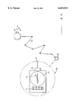
The FIGURE illustrates the navigation system in accordance with the invention during diving and can be used in the method in accordance with the invention.
DETAILED DESCRIPTION OF THE PREFERRED EMBODIMENTS
The navigation system in accordance with the invention comprises a mobile unit carried along by the diver and a "stationary" base station attached, for example, to a boat or equivalent diving station, which units include means for communicating with one another. In the drawing, the base station is denoted by reference numeral 1, the diver is denoted by reference numeral 2 and the mobile or portable unit is denoted by reference numeral 4. The base station 1 includes a communication module 3 such as a transmitter, which communication module 3 can also constitute a transmitter-receiver in view of more versatile communication between the base station and the diver. The mobile unit 4 includes a compass 5 as well as a locating portion, which consists of a communication module 6 such as a receiver (which communication module 6 can be substituted for by a transmitter-receiver in view of more versatile communication with the base station, if desired) and a processor or an equivalent data processing unit provided with a memory and a display 7. Thus, by means of the system, the location of the diver 2 or, more correctly, of the mobile unit 4 carried along by the diver in relation to the base station 1 is determined. In the simplest form of the system, the determination of the location of the mobile unit means just the determination of the direction, i.e., not the actual physical location. This takes place whereby the transmitter 2 of the base station 1 transmits a signal, which is received by the receiver 6 of the locating part of the mobile unit 4, after which the data processing unit determines the direction from the mobile unit 4 to the base station 1, which direction is displayed, for example, by means of a directional arrow 8 provided in the compass 5. The signal can be based, for example, on ultrasound, on electromagnetic wave movement, for example radio waves, or on light.
The determination of the location can be carried out either as constant measurement, as measurements taking place at certain time intervals, or at desired time intervals, or as desired by manually switching on of the system by the diver. The information on the location of the diver, in this particular case exclusively the direction to the base station 1, is stored in the memory of the locating part, in which case, by making use of the compass 5, it is possible to maintain the direction backwards upon completion of the dive when it is desirable to return to the starting point even if the determination of location were not carried out as a constant operation. As is illustrated in the figure in the drawing, the route R of the diver can be even highly twisting. This has, however, no significance for the determination of the direction (or of the distance).
As stated above, by means of the system in accordance with the invention, the distance of the diver from the base station 1 is also determined. This can be based, for example, on the locating part measuring the intensity of the signal transmitted by the transmitter 3 of the base station 1 or the time of travel of the signal between the base station 1 and the portable unit 4 while converting this data to a value of distance, which is shown in the display 7. Determination of the direction and the distance to the base station 1 in a situation in which locating has not yet been carried out is performed so that, by means of the locating part, the direction to the base station 1 is sought by means of direction-finding, in which connection, during the intervals when no measurement is carried out, the information on the direction of the base station is maintained based on the information obtained from the compass 5. Measurement of the direction and the distance requires that the locating part points at least approximately in the direction of the base station. Once the direction of the base station has been determined, this directional information is maintained in the locating part based on the magnetic information on direction obtained from the compass irrespective of whether the diver moves back to the base station along a direct or curved path. However, it is preferable to carry out the determination of the location constantly or at certain time intervals, because in such a case the correct return direction is corrected constantly. In determination of the distance, in order that precise information could be obtained, it is necessary to carry out the measurement constantly or at certain time intervals. If this is not done, the determination of the location must be carried out by direction-finding when needed.
The system can be carried into effect as a number of different versions, of which in the most versatile versions, besides determination of the direction and the distance between the base station and the diver, by means of the system it is also possible to transfer other information between the base station and the diver to a limited extent. In such an embodiment, it is required that both the base station and the mobile unit are provided with transmitter-receivers. As such, by means of a certain signal, the base station might, for example, ask the diver to come back, or similarly, the diver might transmit a message in the form of a certain signal to the base station indicating that he needs help. Also, the base station could determine the distance and the direction of the diver in relation to the base station precisely.
Above, the invention has been described completely by way of example with the aid of the schematic illustration in the accompanying drawing. The invention is, however, not confined to the exemplifying embodiment illustrated in this figure or discussed above, but different embodiments of the invention can show variation within the scope of the inventive idea defined in the accompanying patent claims.

Claims (21)

We claim:
1. A spatial orientation system to facilitate navigation for a diver under water, comprising
a base station fixable at a location to which the diver wants to arrive after completing a dive, said base station comprising transmitter means for transmitting a signal, and
a mobile unit adapted to be carried by the diver, said mobile unit comprising a compass and locating means for determining information on a return direction from the current position of said mobile unit to said base station, said locating means comprising
receiving means for receiving the signal transmitted by said transmitter means of said base station,
converting means for converting the signal to information on the return direction of said mobile unit to said base station upon receipt of the signal by said receiving means, and
combining means for combining said information on the return direction of said mobile unit to said base station from said converting means with magnetic information on the current position of the diver obtained from said compass in order to maintain current information on the return direction irrespective of the momentary location and position of the diver and said mobile unit.
2. The navigation system of claim 1, wherein said locating means of said mobile unit comprises means for determining the location of said mobile unit with respect to said base station from the signal transmitted by said transmitter means of said base station upon receipt of the signal by said locating means.
3. The navigation system of claim 2, wherein said momentary location determining means determine the intensity of said signal transmitted by said transmitter means of said base station and based on the intensity, determine the momentary location of said mobile unit with respect to said base station.
4. The navigation system of claim 2, wherein said momentary location determining means determine the travel time of said signal transmitted by said transmitter means from said base station to said mobile unit and based on the travel time, determine the momentary location of said mobile unit with respect to said base station.
5. The navigation system of claim 2, wherein said locating means of said mobile unit is arranged to continually determine information on the return direction from the current position of said mobile unit to said base station and continually determine the momentary location of said mobile unit with respect to said base station from the signal transmitted by said transmitter means of said base station.
6. The navigation system of claim 2, wherein said locating means of said mobile unit is arranged to determine information on the return direction from the current position of said mobile unit to said base station only at certain predetermined time intervals and determine the momentary location of said mobile unit with respect to said base station from the signal transmitted by said transmitter means of said base station only at certain predetermined time intervals.
7. The navigation system of claim 2, wherein said locating means of said mobile unit is arranged to be manually switched on by the diver to determine information on the return direction from the current position of said mobile unit to said base station and determine the momentary location of said mobile unit with respect to said base station from the signal transmitted by said transmitter means of said base station.
8. The navigation system of claim 1, wherein said base station further comprises receiver means and said mobile unit further comprises transmitter means such that a two-way connection is established between said base station and said mobile unit.
9. The navigation system of claim 1, wherein said transmitter means of said base station are structured and arranged to transmit an ultrasound signal.
10. The navigation system of claim 1, wherein said transmitter means of said base station are structured and arranged to transmit an electromagnetic wave.
11. The navigation system of claim 1, wherein said transmitter means of said base station are structured and arranged to transmit light to be received by said mobile unit.
12. The navigation system of claim 1, wherein said base station is fixed at the location at which the diver began the dive.
13. A method for facilitating navigation for a diver under water to arrive a specific location, comprising
fixing a base station to the location,
transmitting a signal from the base station,
determining information on a return direction from the current position of a mobile unit being carried along by the diver to said base station, said return direction information determining step comprising the steps of receiving the signal transmitted from said base station and converting the signal to information on the return direction, and
maintaining the information on the return direction irrespective of the momentary location and position of the diver by combining the information on the return direction with magnetic information on the current position of the diver obtained from a compass arranged in the mobile unit.
14. The method of claim 13, further comprising the step of:
determining the momentary location of said mobile unit with respect to said base station from the signal transmitted from said base station.
15. The method of claim 13, further comprising the steps of:
determining the intensity of the signal transmitted from said base station, and
determining the momentary location of said mobile unit with respect to said base station based on the intensity.
16. The method of claim 13, further comprising the steps of:
determining the travel time of the signal transmitted from said base station from said base station to said mobile unit, and
determining the momentary location of said mobile unit with respect to said base station based on the travel time.
17. The method of claim 13, further comprising the steps of:
continually determining information on the return direction from the current position of said mobile unit carried along by the diver to said base station, and
continually determining the momentary location of said mobile unit with respect to said base station from the signal transmitted from said base station.
18. The method of claim 13, further comprising the steps of:
determining information on the return direction from the current position of said mobile unto carried along by the diver to said base station only at certain predetermined time intervals, and
determining the momentary location of said mobile unit with respect to said base station from the signal transmitted from said base station only at certain predetermined time intervals.
19. The method of claim 13, further comprising the steps of:
transmitting data from said mobile unit to said base station by arranging a transmitter in connection with said mobile unit and arranging a receiver on connection with said base station.
20. The method of claim 13, wherein said base station is fixed at the location at which the diver began the dive.
21. A spatial orientation system for diving operation to facilitate navigation for a diver under water, comprising
a base station fixable at a location to which the diver wants to arrive after completing a dive, said base station comprising a transmitter for transmitting a signal, and
a mobile unit adapted to be carried by the diver, said mobile unit comprising a compass and a locating system for determining information on a return direction from the current position of said mobile unit to said base station,
said locating system being arranged to receive the signal transmitted by said transmitter of said base station, convert the signal to information on the return direction of said mobile unit to said base station upon receipt of the signal by said locating system, and combine said information on the return direction of said mobile unit to said base station with magnetic information on the current position of the diver obtained from said compass in order to maintain current information on the return direction irrespective of the momentary location and position of the diver and said mobile unit.
US08/768,842 1995-12-21 1996-12-18 Navigation system for diving operations Expired - Lifetime US6029515A (en)

Applications Claiming Priority (2)

Application Number Priority Date Filing Date Title
FI956163A FI107354B (en) 1995-12-21 1995-12-21 Navigation device intended for diving
FI956163 1995-12-21

Publications (1)

Publication Number Publication Date
US6029515A true US6029515A (en) 2000-02-29

Family

ID=8544583

Family Applications (1)

Application Number Title Priority Date Filing Date
US08/768,842 Expired - Lifetime US6029515A (en) 1995-12-21 1996-12-18 Navigation system for diving operations

Country Status (3)

Country Link
US (1) US6029515A (en)
DE (1) DE19649173A1 (en)
FI (1) FI107354B (en)

Cited By (16)

* Cited by examiner, † Cited by third party
Publication number Priority date Publication date Assignee Title
US6272072B1 (en) * 1998-08-14 2001-08-07 Wulich Wave Ltd. Underwater communication method, device, and system utilizing a doppler frequency shift
US6762678B2 (en) 2000-06-27 2004-07-13 Susanne Arens Scuba driver communication and tracking device
US6807127B2 (en) 2001-11-19 2004-10-19 John F. McGeever, Jr. Navigational device for an underwater diver
US20050114024A1 (en) * 2003-10-10 2005-05-26 Johnson Outdoors Inc. System and method for navigating using a digital compass
US20060047428A1 (en) * 2004-08-30 2006-03-02 Adams Phillip M Relative positioning system
US20100110835A1 (en) * 2005-06-15 2010-05-06 Mark Rhodes Underwater navigation
GB2469726A (en) * 2009-04-20 2010-10-27 J & M Inertial Navigation Ltd Personal Navigation Apparatus
US20110141853A1 (en) * 2009-12-16 2011-06-16 Shb Instruments, Inc. Underwater acoustic navigation systems and methods
US8700323B1 (en) * 2009-06-10 2014-04-15 John Souza Underwater navigation system
CN104111072A (en) * 2014-07-28 2014-10-22 福建星网视易信息系统有限公司 Method, device and system for navigation in building
US20160209215A1 (en) * 2014-06-27 2016-07-21 Ariadna Tech Oy Generation of underwater navigational information
US9642415B2 (en) 2011-02-07 2017-05-09 New Balance Athletics, Inc. Systems and methods for monitoring athletic performance
US9772190B2 (en) * 2014-10-14 2017-09-26 Polar Electro Oy Orientation during swimming
US10139469B1 (en) 2014-06-17 2018-11-27 Darren Payne Underwater homing system
US10363453B2 (en) 2011-02-07 2019-07-30 New Balance Athletics, Inc. Systems and methods for monitoring athletic and physiological performance
US11370513B2 (en) 2012-10-08 2022-06-28 Suunto Oy Method of monitoring diving and a system for monitoring or planning a dive

Families Citing this family (2)

* Cited by examiner, † Cited by third party
Publication number Priority date Publication date Assignee Title
DE19914380B4 (en) * 1999-03-30 2004-11-11 Peter Apel Communication and search system for divers
FR2796716B1 (en) * 1999-07-23 2001-12-07 Patrick Mertz ORIENTATION TABLET

Citations (10)

* Cited by examiner, † Cited by third party
Publication number Priority date Publication date Assignee Title
US3489993A (en) * 1967-08-17 1970-01-13 Dynamics Corp America Ultrasonic homing beacon and communication equipment for underwater swimmers
US3736551A (en) * 1970-11-16 1973-05-29 Us Navy Swimmers tactile command navigation apparatus
US4037328A (en) * 1976-06-01 1977-07-26 Her Majesty The Queen In Right Of Canada Spatial orientation device
US4103279A (en) * 1977-07-25 1978-07-25 The United States Of America As Represented By The Secretary Of The Navy Diver navigation system
US5148412A (en) * 1991-02-21 1992-09-15 American Oilfield Divers, Inc. Diver guidance method and system
US5185725A (en) * 1992-04-03 1993-02-09 Dynamics Technology, Inc. Diver locator system
US5187871A (en) * 1992-01-27 1993-02-23 Mcdermott Damien Underwater navigation device
US5241516A (en) * 1992-08-27 1993-08-31 The United States Of America As Represented By The Secretary Of The Navy Diver navigation system
US5303206A (en) * 1992-07-17 1994-04-12 Richard Bemb Method and apparatus for measuring distance and determining direction in a fluid medium
DE4444942A1 (en) * 1994-12-16 1996-06-27 Stn Atlas Elektronik Gmbh Underwater telephony system for submarine communications

Patent Citations (10)

* Cited by examiner, † Cited by third party
Publication number Priority date Publication date Assignee Title
US3489993A (en) * 1967-08-17 1970-01-13 Dynamics Corp America Ultrasonic homing beacon and communication equipment for underwater swimmers
US3736551A (en) * 1970-11-16 1973-05-29 Us Navy Swimmers tactile command navigation apparatus
US4037328A (en) * 1976-06-01 1977-07-26 Her Majesty The Queen In Right Of Canada Spatial orientation device
US4103279A (en) * 1977-07-25 1978-07-25 The United States Of America As Represented By The Secretary Of The Navy Diver navigation system
US5148412A (en) * 1991-02-21 1992-09-15 American Oilfield Divers, Inc. Diver guidance method and system
US5187871A (en) * 1992-01-27 1993-02-23 Mcdermott Damien Underwater navigation device
US5185725A (en) * 1992-04-03 1993-02-09 Dynamics Technology, Inc. Diver locator system
US5303206A (en) * 1992-07-17 1994-04-12 Richard Bemb Method and apparatus for measuring distance and determining direction in a fluid medium
US5241516A (en) * 1992-08-27 1993-08-31 The United States Of America As Represented By The Secretary Of The Navy Diver navigation system
DE4444942A1 (en) * 1994-12-16 1996-06-27 Stn Atlas Elektronik Gmbh Underwater telephony system for submarine communications

Cited By (25)

* Cited by examiner, † Cited by third party
Publication number Priority date Publication date Assignee Title
US6272072B1 (en) * 1998-08-14 2001-08-07 Wulich Wave Ltd. Underwater communication method, device, and system utilizing a doppler frequency shift
US6762678B2 (en) 2000-06-27 2004-07-13 Susanne Arens Scuba driver communication and tracking device
US6807127B2 (en) 2001-11-19 2004-10-19 John F. McGeever, Jr. Navigational device for an underwater diver
US20050114024A1 (en) * 2003-10-10 2005-05-26 Johnson Outdoors Inc. System and method for navigating using a digital compass
US8027785B2 (en) 2004-08-30 2011-09-27 Adams Phillip M Homing display system and method
US20060047428A1 (en) * 2004-08-30 2006-03-02 Adams Phillip M Relative positioning system
US7487043B2 (en) * 2004-08-30 2009-02-03 Adams Phillip M Relative positioning system
US20090171565A1 (en) * 2004-08-30 2009-07-02 Adams Phillip M Diver homing display system and method
US8788201B2 (en) 2004-08-30 2014-07-22 Phillip M. Adams Homing display system
US8315560B2 (en) 2005-06-15 2012-11-20 Wfs Technologies Ltd. Underwater navigation
US20100110835A1 (en) * 2005-06-15 2010-05-06 Mark Rhodes Underwater navigation
GB2469726B (en) * 2009-04-20 2011-06-01 J & M Inertial Navigation Ltd Personal Navigation Apparatus
GB2469726A (en) * 2009-04-20 2010-10-27 J & M Inertial Navigation Ltd Personal Navigation Apparatus
US8700323B1 (en) * 2009-06-10 2014-04-15 John Souza Underwater navigation system
US9645223B2 (en) 2009-12-16 2017-05-09 Shb Instruments, Inc. Underwater acoustic navigation systems and methods
US8654610B2 (en) 2009-12-16 2014-02-18 Shb Instruments, Inc. Underwater acoustic navigation systems and methods
US20110141853A1 (en) * 2009-12-16 2011-06-16 Shb Instruments, Inc. Underwater acoustic navigation systems and methods
US9642415B2 (en) 2011-02-07 2017-05-09 New Balance Athletics, Inc. Systems and methods for monitoring athletic performance
US10363453B2 (en) 2011-02-07 2019-07-30 New Balance Athletics, Inc. Systems and methods for monitoring athletic and physiological performance
US11370513B2 (en) 2012-10-08 2022-06-28 Suunto Oy Method of monitoring diving and a system for monitoring or planning a dive
US10139469B1 (en) 2014-06-17 2018-11-27 Darren Payne Underwater homing system
US20160209215A1 (en) * 2014-06-27 2016-07-21 Ariadna Tech Oy Generation of underwater navigational information
US9746328B2 (en) * 2014-06-27 2017-08-29 Ariadna Tech Oy Generation of underwater navigational information
CN104111072A (en) * 2014-07-28 2014-10-22 福建星网视易信息系统有限公司 Method, device and system for navigation in building
US9772190B2 (en) * 2014-10-14 2017-09-26 Polar Electro Oy Orientation during swimming

Also Published As

Publication number Publication date
FI956163A (en) 1997-06-22
DE19649173A1 (en) 1997-06-26
FI956163A0 (en) 1995-12-21
FI107354B (en) 2001-07-13

Similar Documents

Publication Publication Date Title
US6029515A (en) Navigation system for diving operations
CA2404109A1 (en) Methods and apparatuses for using assistance data relating to satellite position systems
US20040068371A1 (en) Method for determining, recording and sending GPS location data in an underwater environment
CA2292424A1 (en) System, apparatus, and method for geographic positioning of marine fauna
WO2007002246A2 (en) Navigational aid for diver
MY133921A (en) Positioning system, positioning method and positioning device
EP2020608A3 (en) Method and apparatus for determining time for GPS receivers
CA2436706A1 (en) Method and apparatus for determining location using a coarse position estimate
EP0766096A2 (en) Rescue aiding apparatus and search system
US20070140057A1 (en) Location and ranging system for divers
CN110727282A (en) AUV docking method and device and underwater docking system
JP2002311124A (en) Satellite position measuring system
FR2808083B1 (en) METHOD AND DEVICE FOR INSTANT DETERMINATION OF ORIENTATION, BASED ON SATELLITE POSITIONING SIGNALS
JP3204087B2 (en) Tracking radar device
KR20030055893A (en) Service System for Providing Ocean Information
CA2458509C (en) Bistatic azimuth detection system and detection method
CN111537946A (en) Underwater beacon directional positioning system and method
ATE264511T1 (en) METHOD FOR DETERMINING THE ORIENTATION OF A DEFINED AZIMUTAL DIRECTION OF A NAVIGATION DEVICE
CN212301847U (en) Underwater beacon directional positioning system
JP3986512B2 (en) Mobile object display device and mobile object display system
JP3296896B2 (en) Moving object position measurement device
KR101149120B1 (en) Antenna Control unit having satellite search function and method for searching satellite using therefor
JPH05164831A (en) Track display device
WO2000058747A3 (en) Underwater communication method, device, and system utilizing a doppler frequency shift
JP3498051B2 (en) Buoy tracking system

Legal Events

Date Code Title Description
AS Assignment

Owner name: SUUNTO OY, FINLAND

Free format text: ASSIGNMENT OF ASSIGNORS INTEREST;ASSIGNORS:LAHTEENMAKI, ARI;NIKKOLA, ARI;REEL/FRAME:008361/0948

Effective date: 19961202

STCF Information on status: patent grant

Free format text: PATENTED CASE

FPAY Fee payment

Year of fee payment: 4

FEPP Fee payment procedure

Free format text: PAYER NUMBER DE-ASSIGNED (ORIGINAL EVENT CODE: RMPN); ENTITY STATUS OF PATENT OWNER: SMALL ENTITY

Free format text: PAYOR NUMBER ASSIGNED (ORIGINAL EVENT CODE: ASPN); ENTITY STATUS OF PATENT OWNER: SMALL ENTITY

FPAY Fee payment

Year of fee payment: 8

FEPP Fee payment procedure

Free format text: PAYER NUMBER DE-ASSIGNED (ORIGINAL EVENT CODE: RMPN); ENTITY STATUS OF PATENT OWNER: SMALL ENTITY

Free format text: PAYOR NUMBER ASSIGNED (ORIGINAL EVENT CODE: ASPN); ENTITY STATUS OF PATENT OWNER: SMALL ENTITY

FPAY Fee payment

Year of fee payment: 12