US12188867B1 - Method for inversing depth of subsurface chlorophyll-a maxima of oceanic water body based on remote sensing reflectance - Google Patents
Method for inversing depth of subsurface chlorophyll-a maxima of oceanic water body based on remote sensing reflectance Download PDFInfo
- Publication number
- US12188867B1 US12188867B1 US18/890,715 US202418890715A US12188867B1 US 12188867 B1 US12188867 B1 US 12188867B1 US 202418890715 A US202418890715 A US 202418890715A US 12188867 B1 US12188867 B1 US 12188867B1
- Authority
- US
- United States
- Prior art keywords
- remote sensing
- scm
- chlorophyll
- sensing reflectance
- data
- Prior art date
- Legal status (The legal status is an assumption and is not a legal conclusion. Google has not performed a legal analysis and makes no representation as to the accuracy of the status listed.)
- Active
Links
- ATNHDLDRLWWWCB-AENOIHSZSA-M chlorophyll a Chemical compound C1([C@@H](C(=O)OC)C(=O)C2=C3C)=C2N2C3=CC(C(CC)=C3C)=[N+]4C3=CC3=C(C=C)C(C)=C5N3[Mg-2]42[N+]2=C1[C@@H](CCC(=O)OC\C=C(/C)CCC[C@H](C)CCC[C@H](C)CCCC(C)C)[C@H](C)C2=C5 ATNHDLDRLWWWCB-AENOIHSZSA-M 0.000 title claims abstract description 105
- 229930002868 chlorophyll a Natural products 0.000 title claims abstract description 105
- 238000000034 method Methods 0.000 title claims abstract description 56
- XLYOFNOQVPJJNP-UHFFFAOYSA-N water Substances O XLYOFNOQVPJJNP-UHFFFAOYSA-N 0.000 title claims abstract description 47
- 238000004364 calculation method Methods 0.000 claims abstract description 29
- 238000010276 construction Methods 0.000 claims abstract description 5
- 238000013480 data collection Methods 0.000 claims abstract description 5
- 238000012935 Averaging Methods 0.000 claims description 4
- 238000003384 imaging method Methods 0.000 claims description 4
- 238000012545 processing Methods 0.000 claims description 4
- 238000010801 machine learning Methods 0.000 abstract description 16
- 230000006870 function Effects 0.000 description 28
- 230000003287 optical effect Effects 0.000 description 6
- 230000000694 effects Effects 0.000 description 5
- OKTJSMMVPCPJKN-UHFFFAOYSA-N Carbon Chemical compound [C] OKTJSMMVPCPJKN-UHFFFAOYSA-N 0.000 description 2
- 230000009286 beneficial effect Effects 0.000 description 2
- 229910052799 carbon Inorganic materials 0.000 description 2
- 238000004177 carbon cycle Methods 0.000 description 2
- 238000005516 engineering process Methods 0.000 description 2
- 230000004907 flux Effects 0.000 description 2
- 238000012549 training Methods 0.000 description 2
- 241000251468 Actinopterygii Species 0.000 description 1
- 241000238557 Decapoda Species 0.000 description 1
- 230000001419 dependent effect Effects 0.000 description 1
- 238000010586 diagram Methods 0.000 description 1
- 230000007613 environmental effect Effects 0.000 description 1
- 239000000463 material Substances 0.000 description 1
- 230000029553 photosynthesis Effects 0.000 description 1
- 238000010672 photosynthesis Methods 0.000 description 1
- 239000000049 pigment Substances 0.000 description 1
- 238000007781 pre-processing Methods 0.000 description 1
- 238000002360 preparation method Methods 0.000 description 1
- 235000015170 shellfish Nutrition 0.000 description 1
Images


Classifications
-
- G—PHYSICS
- G01—MEASURING; TESTING
- G01N—INVESTIGATING OR ANALYSING MATERIALS BY DETERMINING THEIR CHEMICAL OR PHYSICAL PROPERTIES
- G01N21/00—Investigating or analysing materials by the use of optical means, i.e. using sub-millimetre waves, infrared, visible or ultraviolet light
- G01N21/17—Systems in which incident light is modified in accordance with the properties of the material investigated
- G01N21/55—Specular reflectivity
-
- G—PHYSICS
- G01—MEASURING; TESTING
- G01N—INVESTIGATING OR ANALYSING MATERIALS BY DETERMINING THEIR CHEMICAL OR PHYSICAL PROPERTIES
- G01N33/00—Investigating or analysing materials by specific methods not covered by groups G01N1/00 - G01N31/00
- G01N33/18—Water
-
- G—PHYSICS
- G01—MEASURING; TESTING
- G01N—INVESTIGATING OR ANALYSING MATERIALS BY DETERMINING THEIR CHEMICAL OR PHYSICAL PROPERTIES
- G01N21/00—Investigating or analysing materials by the use of optical means, i.e. using sub-millimetre waves, infrared, visible or ultraviolet light
- G01N21/17—Systems in which incident light is modified in accordance with the properties of the material investigated
- G01N21/25—Colour; Spectral properties, i.e. comparison of effect of material on the light at two or more different wavelengths or wavelength bands
- G01N21/31—Investigating relative effect of material at wavelengths characteristic of specific elements or molecules, e.g. atomic absorption spectrometry
-
- G—PHYSICS
- G01—MEASURING; TESTING
- G01N—INVESTIGATING OR ANALYSING MATERIALS BY DETERMINING THEIR CHEMICAL OR PHYSICAL PROPERTIES
- G01N21/00—Investigating or analysing materials by the use of optical means, i.e. using sub-millimetre waves, infrared, visible or ultraviolet light
- G01N21/17—Systems in which incident light is modified in accordance with the properties of the material investigated
- G01N2021/1793—Remote sensing
-
- G—PHYSICS
- G01—MEASURING; TESTING
- G01N—INVESTIGATING OR ANALYSING MATERIALS BY DETERMINING THEIR CHEMICAL OR PHYSICAL PROPERTIES
- G01N21/00—Investigating or analysing materials by the use of optical means, i.e. using sub-millimetre waves, infrared, visible or ultraviolet light
- G01N21/17—Systems in which incident light is modified in accordance with the properties of the material investigated
- G01N21/55—Specular reflectivity
- G01N2021/557—Detecting specular reflective parts on sample
-
- G—PHYSICS
- G01—MEASURING; TESTING
- G01N—INVESTIGATING OR ANALYSING MATERIALS BY DETERMINING THEIR CHEMICAL OR PHYSICAL PROPERTIES
- G01N2201/00—Features of devices classified in G01N21/00
- G01N2201/12—Circuits of general importance; Signal processing
- G01N2201/126—Microprocessor processing
Definitions
- the disclosure relates to the field of preparation of water color remote sensing technologies, particularly to a method for inversing a depth of a subsurface chlorophyll-a maxima of an oceanic water body based on remote sensing reflectance.
- Chlorophyll-a (also referred to as chl-a) is a main pigment in cells of the marine phytoplankton, and it is an important indicator to measure the amount of the marine phytoplankton.
- the marine phytoplankton provides basic materials and energy for the whole marine ecosystem through photosynthesis.
- the marine phytoplankton is a natural bait for marine organisms such as shellfish, shrimp and fish larvae, and these marine organisms will migrate with the change of the chlorophyll-a concentration.
- a depth of an SCM of an oceanic water body is an important index to estimate a vertical distribution of the chlorophyll-a, a key parameter to estimate a global carbon flux and the global primary productivity, an important index to measure an ecological effect caused by global climate change, and one of key parameters to be solved urgently in ocean color remote sensing.
- a remote sensing reflectance signal in an ocean region is mainly influenced by the vertical distribution and chlorophyll-a concentration, and remote sensing reflectance characteristics generated by distribution of the remote sensing reflectance signal can effectively indicate the depth of the SCM. Inversing and obtaining the depth of the SCM based on the remote sensing reflectance is an important basis for understanding a primary productivity of the ocean, and it is of great significance to water ecological protection, global carbon cycle and global climate change on a macro scale.
- the inversing of the SCM of the oceanic water body mainly includes a method for inversing the depth of the SCM based on a Gaussian kernel function model and a method for inversing the depth of the SCM based on machine learning.
- the details for the above two methods are as follows. (1) For the method for inversing the depth of the SCM based on the Gaussian kernel function model: firstly, it is assumed that the vertical distribution of the chlorophyll-a concentration to a Gaussian function:
- Chla ⁇ ( z ) Chla 0 + h ⁇ ⁇ 2 ⁇ ⁇ ⁇ exp [ - ( Z - Z s ⁇ c ⁇ m ) 2 2 ⁇ ⁇ 2 ] .
- Z scm represents the depth of the SCM, which indicates the depth where the SCM is located, and this method can estimate the depth of the SCM by using a chlorophyll-a concentration in a sea surface inversed by satellite.
- this method is very dependent on an inversion accuracy of the subsurface chlorophyll-a concentration, and the subsurface chlorophyll-a concentration does not all conform to Gaussian function distribution, so the inversion accuracy of this method is lower, and the calculation method is complicated and requires a large amount of calculation.
- this method needs a lot of chlorophyll-a profile data for training.
- a lot of computing resources need to be consumed, which is expensive. Therefore, it is particularly important to propose an algorithm for calculating the depth of the SCM only by remote sensing reflectance.
- the method for inversing the depth of the SCM based on the Gaussian kernel function model and the method for inversing the depth of the SCM based on the machine learning still have the shortcomings of lack of effective optical and physical basis, and can not make good use of the remote sensing reflectance characteristics caused by the depth of the SCM.
- the disclosure provides a method for inversing a depth of an SCM of an oceanic water body based on remote sensing reflectance. It could solve the problem that the method for inversing the depth of the SCM based on the Gaussian kernel function model and the method for inversing the depth of the SCM based on the machine learning still have the shortcomings of lack of effective optical and physical basis.
- a method for inversing a depth of an SCM of an oceanic water body based on remote sensing reflectance includes: step 1, band selection, including: obtaining a remote sensing reflectance data from a moderate-resolution imaging spectroradiometer (MODIS) remote sensing data, and selecting target remote sensing reflectance data corresponding to three bands of 412 nanometers (nm), 555 nm and 678 nm from the remote sensing reflectance data; step 2, R value calculation, including: calculating a difference between a remote sensing reflectance corresponding to the band 412 nm from the target remote sensing reflectance data and a remote sensing reflectance corresponding to the band 678 nm from the target remote sensing reflectance data, and calculating a ratio of the difference to a remote sensing reflectance corresponding to the band 555 nm from the target remote sensing reflectance data as a R value; step 3, data collection, including: obtaining groups of global measured biogeochemical-automatic reporting oceanographic
- the R value is a ratio obtained by an operation of the remote sensing reflectance corresponding to the band 412 nm, the remote sensing reflectance corresponding to the band 678 nm, and the remote sensing reflectance corresponding to the band 555 nm.
- a formula for calculating the R value is expressed as follows:
- R ( R ⁇ r ⁇ s 4 ⁇ 1 ⁇ 2 - R ⁇ r ⁇ s 6 ⁇ 7 ⁇ 8 ) R ⁇ r ⁇ s 5 ⁇ 5 ⁇ 5 ,
- an unknown number X is replaced with the R value obtained based on the remote sensing reflectance corresponding to the band 412 nm, the remote sensing reflectance corresponding to the band 678 nm, and the remote sensing reflectance corresponding to the band 555 nm, and the function expression of the nonlinear model is finally expressed as:
- Z S ⁇ C ⁇ M a 0 + a 1 ⁇ ( R ⁇ r ⁇ s 4 ⁇ 1 ⁇ 2 - R ⁇ r ⁇ s 6 ⁇ 7 ⁇ 8 ) R ⁇ r ⁇ s 5 ⁇ 5 ⁇ 5 + a 2 ( ( R ⁇ r ⁇ s 4 ⁇ 1 ⁇ 2 - R ⁇ r ⁇ s 6 ⁇ 7 ⁇ 8 ) R ⁇ r ⁇ s 5 ⁇ 5 ⁇ 5 ) 2 .
- the calculating a depth of an SCM of each group of the groups of global measured BGC-Argo chlorophyll-a concentration profile data according to the BGC-Argo chlorophyll-a profile, as Z SCM specifically includes:
- Chla ⁇ ( z ) C ⁇ h ⁇ l ⁇ a 0 + h ⁇ ⁇ 2 ⁇ ⁇ ⁇ exp [ - ( Z - Z s ⁇ c ⁇ m ) 2 2 ⁇ ⁇ 2 ] ,
- a 0 , a 1 and a 2 are coefficients obtained by matching the groups of global measured BGC-Argo chlorophyll-a concentration profile data with the group of data and performing nonlinear fitting.
- the R value corresponding to Z SCM obtained by BGC-Argo is obtained by searching and matching a global R value corresponding latitudes, longitudes and time based on latitude and longitude data where the BGC-Argo is located.
- the method further includes: applying the depth of the SCM of the oceanic water body in determining a primary productivity of the oceanic water body, performing water ecological protection of the oceanic water body based on the primary productivity of the oceanic water body, and performing estimation of global carbon cycle and global climate change based on the primary productivity of the oceanic water body to perform environmental protection according to a estimation result to thereby achievie stability and sustainability of a global ecosystem.
- the disclosure provides a method for inversing a depth of an SCM of an oceanic water body based on remote sensing reflectance, which has the following beneficial effects.
- a nonlinear regression model is combined with remote sensing reflectance characteristics correpondings to three bands of 412 nm, 555 nm and 678 nm caused by vertical distribution of different chlorophyll-a concentrations to inverse a depth of an SCM of an ocean water body.
- This method can effectively contain optical characteristic signals caused by the vertical distribution of different chlorophyll-a concentrations, and can simply and quickly retrieve the depth of the SCM of the ocean water body by relying on the remote sensing reflectance data obtained by satellite remote sensing, with a small amount of calculation, which reduces the dependence of machine learning on chlorophyll-a concentrations, sea surface temperature data and sea surface height data, and reduces the calculation resource consumption of running machine learning.
- the method for inversing a depth of an SCM of an oceanic water body based on remote sensing reflectance in the disclosure uses more optical characteristic signals, thus effectively improving the inversion accuracy.
- FIG. 1 illustrates a schematic flow chart of a method for inversing a depth of a subsurface chlorophyll-a maxima of an oceanic water body based on remote sensing reflectance according to an embodiment of the disclosure.
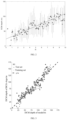
- FIG. 2 illustrates a graph showing a depth regression relationship between R values and depths of the SCM (i.e., SCM depths) according to an embodiment of the disclosure.
- FIG. 3 illustrates a comparison diagram of the depth of the SCM inversed by the method of the disclosure and the depth of the SCM observed by the BGC-Argo.
- a method for inversing a depth of a subsurface chlorophyll-a maxima of an oceanic water body based on remote sensing reflectance includes the following steps.
- band selection is performed, which specifically includes: obtaining a remote sensing reflectance data from a moderate-resolution imaging spectroradiometer (MODIS) remote sensing data, and selecting target remote sensing reflectance data corresponding to three bands of 412 nanometers (nm), 555 nm and 678 nm from the remote sensing reflectance data.
- MODIS moderate-resolution imaging spectroradiometer
- R value calculation is performed, which specifically includes: calculating a difference between a remote sensing reflectance corresponding to the band 412 nm from the target remote sensing reflectance data and a remote sensing reflectance corresponding to the band 678 nm from the target remote sensing reflectance data, and calculating a ratio of the difference to a remote sensing reflectance corresponding to the band 555 nm from the target remote sensing reflectance data as a R value.
- step 3 data collection is performed, which specifically includes: obtaining groups of global measured biogeochemical-automatic reporting oceanographic observers (BGC-Argo) chlorophyll-a concentration profile data, fitting a BGC-Argo chlorophyll-a profile by using a Gaussian function according to the groups of global measured BGC-Argo chlorophyll-a concentration profile data, calculating a depth of an SCM of each group of the groups of global measured BGC-Argo chlorophyll-a concentration profile data according to the BGC-Argo chlorophyll-a profile, as Z SCM , and recording BGC-Argo latitude and longitude data.
- BGC-Argo biogeochemical-automatic reporting oceanographic observers
- the obtained groups of global measured biogeochemical-automatic reporting oceanographic observers (BGC-Argo) chlorophyll-a concentration profile data are data from an equatorial pacific, a northwest pacific, a southern ocean, an indian ocean, an atlantic ocean and other regions, which not only contain higher chlorophyll-a concentration regions, but also contain lower chlorophyll-a concentration regions, and have strong universality.
- model construction is performed, which specifically includes: matching the BGC-Argo latitude and longitude data with MODIS remote sensing reflectance corresponding to latitudes and longitudes, obtaining a grid point through BGC-Argo latitude and longitude positioning, obtaining remote sensing reflectance data of two grid points around the grid point, calculating groups of R values according to the remote sensing reflectance data of the two grid points, averaging the obtained groups of R values to obtain a group of data, and matching the groups of global measured BGC-Argo chlorophyll-a concentration profile data with the group of data to obtain a group of depths of SCM, taking the group of data as an input feature and the group of depths of SCM as an output feature to thereby obtain a matching data set, and drawing a scatter plot for Z SCM and R value by using the matching data set to thereby obtain a nonlinear model.
- Z SCM calculation is performed, which specifically includes: obtaining, according to the nonlinear model obtained in the step 4, a function expression of the nonlinear model, and performing regression processing based on the function expression of the nonlinear model and the group of depths of SCM to obtain the depth of the SCM of the oceanic water body.
- a nonlinear regression model is combined with remote sensing reflectance characteristics correpondings to three bands of 412 nm, 555 nm and 678 nm caused by vertical distribution of different chlorophyll-a concentrations to inverse a depth of an SCM of an ocean water body.
- This method can effectively contain optical characteristic signals caused by the vertical distribution of different chlorophyll-a concentrations, and can simply and quickly retrieve the depth of the SCM of the ocean water body by relying on the remote sensing reflectance data obtained by satellite remote sensing, with a small amount of calculation, which reduces the dependence of machine learning on chlorophyll-a concentrations, sea surface temperature data and sea surface height data, and reduces the calculation resource consumption of running machine learning.
- the R value is a ratio obtained by an operation of the remote sensing reflectance corresponding to the band 412 nm, the remote sensing reflectance corresponding to the band 678 nm, and the remote sensing reflectance corresponding to the band 555 nm.
- a formula for calculating the R value is expressed as follows:
- R ( R ⁇ r ⁇ s 4 ⁇ 1 ⁇ 2 - R ⁇ r ⁇ s 6 ⁇ 7 ⁇ 8 ) R ⁇ r ⁇ s 5 ⁇ 5 ⁇ 5 ,
- an unknown number X is replaced with the R value obtained based on the remote sensing reflectance corresponding to the band 412 nm, the remote sensing reflectance corresponding to the band 678 nm, and the remote sensing reflectance corresponding to the band 555 nm, and the function expression of the nonlinear model is finally expressed as:
- Z S ⁇ C ⁇ M a 0 + a 1 ⁇ ( R ⁇ r ⁇ s 4 ⁇ 1 ⁇ 2 - R ⁇ r ⁇ s 6 ⁇ 7 ⁇ 8 ) R ⁇ r ⁇ s 5 ⁇ 5 ⁇ 5 + a 2 ( ( R ⁇ r ⁇ s 4 ⁇ 1 ⁇ 2 - R ⁇ r ⁇ s 6 ⁇ 7 ⁇ 8 ) R ⁇ r ⁇ s 5 ⁇ 5 ⁇ 5 ) 2 .
- the calculating a depth of an SCM of each group of the groups of global measured BGC-Argo chlorophyll-a concentration profile data according to the BGC-Argo chlorophyll-a profile, as Z SCM specifically includes:
- Chla ⁇ ( z ) C ⁇ h ⁇ l ⁇ a 0 + h ⁇ ⁇ 2 ⁇ ⁇ ⁇ exp [ - ( Z - Z s ⁇ c ⁇ m ) 2 2 ⁇ ⁇ 2 ] ,
- a 0 , a 1 and a 2 are coefficients obtained by matching the groups of global measured BGC-Argo chlorophyll-a concentration profile data with the group of data and performing nonlinear fitting.
- the R value corresponding to Z SCM obtained by BGC-Argo is obtained by searching and matching a global R value corresponding latitudes, longitudes and time based on latitude and longitude data where the BGC-Argo is located.
- the method further includes: applying the depth of the SCM to estimate a vertical distribution of the chlorophyll-a concentration, estimate a global carbon flux and a global primary productivity, and measure an ecological effect caused by global climate change.
- the method in the disclosure has a good effect on inversion of the depth of the SCM, with a mean absolute error (MAE) of 10.87, a determination coefficient R 2 of 0.85 and a root mean square error (RMSE) of 13.75.
- the calculation amount is significantly reduced compared with the method for inversing the depth of the SCM based on the machine learning, effectively reducing the calculation resource consumption and inversion difficulty of inversing the SCM.
- a method for inversing a depth of a subsurface chlorophyll-a maxima of an oceanic water body based on remote sensing reflectance includes the following steps.
- band selection is performed, which specifically includes: obtaining a remote sensing reflectance data from a moderate-resolution imaging spectroradiometer (MODIS) remote sensing data, selecting target remote sensing reflectance data corresponding to three bands of 412 nanometers (nm), 555 nm and 678 nm from the remote sensing reflectance data, and preprocessing the target remote sensing reflectance data to obtain target remote sensing reflectance data.
- MODIS moderate-resolution imaging spectroradiometer
- R value calculation is performed, which specifically includes: calculating a difference between a remote sensing reflectance corresponding to the band 412 nm from the target remote sensing reflectance data and a remote sensing reflectance corresponding to the band 678 nm from the target remote sensing reflectance data, and calculating a ratio of the difference to a remote sensing reflectance corresponding to the band 555 nm from the target remote sensing reflectance data as a R value.
- step 3 data collection is performed, which specifically includes: obtaining groups of global measured biogeochemical-automatic reporting oceanographic observers (BGC-Argo) chlorophyll-a concentration profile data, fitting a BGC-Argo chlorophyll-a profile by using a Gaussian function according to the groups of global measured BGC-Argo chlorophyll-a concentration profile data, calculating a depth of an SCM of each group of the groups of global measured BGC-Argo chlorophyll-a concentration profile data according to the BGC-Argo chlorophyll-a profile, as Z SCM , and recording BGC-Argo latitude and longitude data.
- BGC-Argo biogeochemical-automatic reporting oceanographic observers
- the obtained groups of global measured biogeochemical-automatic reporting oceanographic observers (BGC-Argo) chlorophyll-a concentration profile data are data from an equatorial pacific, a northwest pacific, a southern ocean, an indian ocean, an atlantic ocean and other regions, which not only contain higher chlorophyll-a concentration regions, but also contain lower chlorophyll-a concentration regions, and have strong universality.
- model construction is performed, which specifically includes: matching the BGC-Argo latitude and longitude data with MODIS remote sensing reflectance corresponding to latitudes and longitudes, obtaining a grid point through BGC-Argo latitude and longitude positioning, obtaining remote sensing reflectance data of two grid points around the grid point, calculating R values according to the remote sensing reflectance data of the two grid points, averaging the obtained R values to obtain a group of data, and matching the groups of global measured BGC-Argo chlorophyll-a concentration profile data with the group of data to obtain a group of depths of SCM, taking the group of data as an input feature and the group of depths of SCM as an output feature to thereby obtain a matching data set, and drawing a scatter plot for Z SCM and R value by using the matching data set to thereby obtain a nonlinear model.
- Z SCM calculation is performed, which specifically includes: obtaining, according to the nonlinear model obtained in the step 4, a function expression of the nonlinear model, and performing regression processing based on the function expression of the nonlinear model and R values of remote sensing reflectance with different vertical distribution of chlorophyll-a concentration to obtain the depth of the SCM of the oceanic water body.
- a nonlinear regression model is combined with remote sensing reflectance characteristics correpondings to three bands of 412 nm, 555 nm and 678 nm caused by vertical distribution of different chlorophyll-a concentrations to inverse a depth of an SCM of an ocean water body.
- This method can effectively contain optical characteristic signals caused by the vertical distribution of different chlorophyll-a concentrations, and can simply and quickly retrieve the depth of the SCM of the ocean water body by relying on the remote sensing reflectance data obtained by satellite remote sensing, with a small amount of calculation, which reduces the dependence of machine learning on chlorophyll-a concentrations, sea surface temperature data and sea surface height data, and reduces the calculation resource consumption of running machine learning.
- the R value is a ratio obtained by an operation of the remote sensing reflectance corresponding to the band 412 nm, the remote sensing reflectance corresponding to the band 678 nm, and the remote sensing reflectance corresponding to the band 555 nm.
- a formula for calculating the R value is expressed as follows:
- R ( R ⁇ r ⁇ s 4 ⁇ 1 ⁇ 2 - R ⁇ r ⁇ s 6 ⁇ 7 ⁇ 8 ) R ⁇ r ⁇ s 5 ⁇ 5 ⁇ 5 ,
- an unknown number X is replaced with the R value obtained based on the remote sensing reflectance corresponding to the band 412 nm, the remote sensing reflectance corresponding to the band 678 nm, and the remote sensing reflectance corresponding to the band 555 nm, and the function expression of the nonlinear model is finally expressed as:
- Z S ⁇ C ⁇ M a 0 + a 1 ⁇ ( R ⁇ r ⁇ s 4 ⁇ 1 ⁇ 2 - R ⁇ r ⁇ s 6 ⁇ 7 ⁇ 8 ) R ⁇ r ⁇ s 5 ⁇ 5 ⁇ 5 + a 2 ( ( R ⁇ r ⁇ s 4 ⁇ 1 ⁇ 2 - R ⁇ r ⁇ s 6 ⁇ 7 ⁇ 8 ) R ⁇ r ⁇ s 5 ⁇ 5 ⁇ 5 ) 2 .
- the calculating a depth of an SCM of each group of the groups of global measured BGC-Argo chlorophyll-a concentration profile data according to the BGC-Argo chlorophyll-a profile, as Z SCM specifically includes:
- Chla ⁇ ( z ) C ⁇ h ⁇ l ⁇ a 0 + h ⁇ ⁇ 2 ⁇ ⁇ ⁇ exp [ - ( Z - Z s ⁇ c ⁇ m ) 2 2 ⁇ ⁇ 2 ] ,
- a 0 , a 1 and a 2 are coefficients obtained by matching the groups of global measured BGC-Argo chlorophyll-a concentration profile data with the group of data and performing nonlinear fitting.
- R value data corresponding to Z SCM obtained by BGC-Argo is obtained by searching the global corresponding latitude and longitude and matching the R value corresponding to time through latitude and longitude data where BGC-Argo is located.
- the method in the disclosure has a good effect on inversion of the depth of the SCM, with a mean absolute error (MAE) of 10.87, a determination coefficient R 2 of 0.85 and a root mean square error (RMSE) of 13.75.
- the calculation amount is significantly reduced compared with the method for inversing the depth of the SCM based on the machine learning, effectively reducing the calculation resource consumption and inversion difficulty of inversing the SCM.
Landscapes
- Physics & Mathematics (AREA)
- Chemical & Material Sciences (AREA)
- Health & Medical Sciences (AREA)
- Life Sciences & Earth Sciences (AREA)
- Biochemistry (AREA)
- Analytical Chemistry (AREA)
- General Health & Medical Sciences (AREA)
- General Physics & Mathematics (AREA)
- Immunology (AREA)
- Pathology (AREA)
- Spectroscopy & Molecular Physics (AREA)
- Engineering & Computer Science (AREA)
- Food Science & Technology (AREA)
- Medicinal Chemistry (AREA)
- Investigating Or Analysing Materials By Optical Means (AREA)
Abstract
A method for inversing a depth of a subsurface chlorophyll-a maxima (SCM) of an oceanic water body based on remote sensing reflectance is provided. The method includes: band selection, R value calculation, data collection, model construction, and ZSCM calculation. This method can not only reduce the dependence of machine learning on sea surface chlorophyll-a concentrations, sea surface temperature data and sea surface height data, and reduce the calculation resource consumption of running machine learning, but also effectively improve the inversion accuracy, and effectively reduce the calculation resource consumption and inversion difficulty of inversing the SCM.
Description
This application claims priority to Chinese Patent Application No. 202311760855.X, filed on Dec. 19, 2023, which is herein incorporated by reference in its entirety.
The disclosure relates to the field of preparation of water color remote sensing technologies, particularly to a method for inversing a depth of a subsurface chlorophyll-a maxima of an oceanic water body based on remote sensing reflectance.
Phytoplankton is an important part of an ocean and plays an important role in a marine ecosystem, and contributes about 50% of a global primary productivity. Chlorophyll-a (also referred to as chl-a) is a main pigment in cells of the marine phytoplankton, and it is an important indicator to measure the amount of the marine phytoplankton. As a producer in the marine ecosystem, the marine phytoplankton provides basic materials and energy for the whole marine ecosystem through photosynthesis. Furthermore, the marine phytoplankton is a natural bait for marine organisms such as shellfish, shrimp and fish larvae, and these marine organisms will migrate with the change of the chlorophyll-a concentration. Therefore, a vertical distribution of the chlorophyll-a concentration in the ocean is uneven, however, the chlorophyll-a concentration obtained by traditional remote sensing is often an integral of a concentration of a chlorophyll-a in a whole water column, so observing a vertical structure of the chlorophyll-a concentration has become an urgent problem to be solved in the water color remote sensing technologies. Studies show that there is always a maximum chlorophyll-a concentration in an ocean subsurface, which is called a subsurface chlorophyll-a maxima (SCM). A depth of an SCM of an oceanic water body is an important index to estimate a vertical distribution of the chlorophyll-a, a key parameter to estimate a global carbon flux and the global primary productivity, an important index to measure an ecological effect caused by global climate change, and one of key parameters to be solved urgently in ocean color remote sensing. A remote sensing reflectance signal in an ocean region is mainly influenced by the vertical distribution and chlorophyll-a concentration, and remote sensing reflectance characteristics generated by distribution of the remote sensing reflectance signal can effectively indicate the depth of the SCM. Inversing and obtaining the depth of the SCM based on the remote sensing reflectance is an important basis for understanding a primary productivity of the ocean, and it is of great significance to water ecological protection, global carbon cycle and global climate change on a macro scale.
At present, the inversing of the SCM of the oceanic water body mainly includes a method for inversing the depth of the SCM based on a Gaussian kernel function model and a method for inversing the depth of the SCM based on machine learning. The details for the above two methods are as follows. (1) For the method for inversing the depth of the SCM based on the Gaussian kernel function model: firstly, it is assumed that the vertical distribution of the chlorophyll-a concentration to a Gaussian function:
Zscm represents the depth of the SCM, which indicates the depth where the SCM is located, and this method can estimate the depth of the SCM by using a chlorophyll-a concentration in a sea surface inversed by satellite. However, this method is very dependent on an inversion accuracy of the subsurface chlorophyll-a concentration, and the subsurface chlorophyll-a concentration does not all conform to Gaussian function distribution, so the inversion accuracy of this method is lower, and the calculation method is complicated and requires a large amount of calculation. (2) For the method for inversing the depth of the SCM based on the machine learning: at present, the method needs many parameters, such as sea surface temperature, sea surface height and sea surface chlorophyll-a concentration. Moreover, this method needs a lot of chlorophyll-a profile data for training. In the process of machine learning model training, a lot of computing resources need to be consumed, which is expensive. Therefore, it is particularly important to propose an algorithm for calculating the depth of the SCM only by remote sensing reflectance.
In addition, the method for inversing the depth of the SCM based on the Gaussian kernel function model and the method for inversing the depth of the SCM based on the machine learning still have the shortcomings of lack of effective optical and physical basis, and can not make good use of the remote sensing reflectance characteristics caused by the depth of the SCM.
Aiming at the shortcomings of the related art, the disclosure provides a method for inversing a depth of an SCM of an oceanic water body based on remote sensing reflectance. It could solve the problem that the method for inversing the depth of the SCM based on the Gaussian kernel function model and the method for inversing the depth of the SCM based on the machine learning still have the shortcomings of lack of effective optical and physical basis.
In order to achieve the above objectives, the following technical solutions are provided.
In an embodiment, a method for inversing a depth of an SCM of an oceanic water body based on remote sensing reflectance is provided, which includes: step 1, band selection, including: obtaining a remote sensing reflectance data from a moderate-resolution imaging spectroradiometer (MODIS) remote sensing data, and selecting target remote sensing reflectance data corresponding to three bands of 412 nanometers (nm), 555 nm and 678 nm from the remote sensing reflectance data; step 2, R value calculation, including: calculating a difference between a remote sensing reflectance corresponding to the band 412 nm from the target remote sensing reflectance data and a remote sensing reflectance corresponding to the band 678 nm from the target remote sensing reflectance data, and calculating a ratio of the difference to a remote sensing reflectance corresponding to the band 555 nm from the target remote sensing reflectance data as a R value; step 3, data collection, including: obtaining groups of global measured biogeochemical-automatic reporting oceanographic observers (BGC-Argo) chlorophyll-a concentration profile data, fitting a BGC-Argo chlorophyll-a profile by using a Gaussian function according to the groups of global measured BGC-Argo chlorophyll-a concentration profile data, calculating a depth of an SCM of each group of the groups of global measured BGC-Argo chlorophyll-a concentration profile data according to the BGC-Argo chlorophyll-a profile, as ZSCM, and recording BGC-Argo latitude and longitude data; step 4, model construction, including: matching the BGC-Argo latitude and longitude data with MODIS remote sensing reflectance (i.e., the target remote sensing reflectance data) corresponding to latitudes and longitudes, obtaining a grid point through BGC-Argo latitude and longitude positioning, obtaining remote sensing reflectance data of two grid points around the grid point, calculating groups of R values according to the remote sensing reflectance data of the two grid points, averaging the obtained groups of R values to obtain a group of data, and matching the groups of global measured BGC-Argo chlorophyll-a concentration profile data with the group of data to obtain a group of depths of SCM, taking the group of data as an input feature and the group of depths of SCM as an output feature to thereby obtain a matching data set, and drawing a scatter plot for ZSCM and R value by using the matching data set to thereby obtain a nonlinear model; and step 5, ZSCM calculation, including: obtaining, according to the nonlinear model obtained in the step 4, a function expression of the nonlinear model, and performing regression processing based on the function expression of the nonlinear model and the group of depths of SCM to obtain the depth of the SCM of the oceanic water body.
In an embodiment, in the step 2, the R value is a ratio obtained by an operation of the remote sensing reflectance corresponding to the band 412 nm, the remote sensing reflectance corresponding to the band 678 nm, and the remote sensing reflectance corresponding to the band 555 nm.
In an embodiment, a formula for calculating the R value is expressed as follows:
-
- where Rrs412 represents the remote sensing reflectance corresponding to the band 412 nm, Rrs678 represents the remote sensing reflectance corresponding to the band 678 nm, and Rrs555 represents the remote sensing reflectance corresponding to the band 555 nm.
In an embodiment, the function expression of the nonlinear model is expressed as:
Z SCM =a 0 +a 1 X+a 2 X 2.
Z SCM =a 0 +a 1 X+a 2 X 2.
In an embodiment, an unknown number X is replaced with the R value obtained based on the remote sensing reflectance corresponding to the band 412 nm, the remote sensing reflectance corresponding to the band 678 nm, and the remote sensing reflectance corresponding to the band 555 nm, and the function expression of the nonlinear model is finally expressed as:
In an embodiment, the calculating a depth of an SCM of each group of the groups of global measured BGC-Argo chlorophyll-a concentration profile data according to the BGC-Argo chlorophyll-a profile, as ZSCM, specifically includes:
-
- fitting the BGC-Argo chlorophyll-a profile by using a Gaussian kernel function to obtain the depth of the SCM of each group of the groups of global measured BGC-Argo chlorophyll-a concentration profile data, as ZSCM;
- where a formula for the fitting the BGC-Argo chlorophyll-a profile is expressed as:
-
- where Chla0 represents a chlorophyll-a concentration at a sea surface, σ represents a variance of subsurface chlorophyll-a concentration, h represents a total amount of the subsurface chlorophyll-a concentration within a Gaussian peak width (i.e., 4σ), ZSCM represents a depth of a maximum concentration in the BGC-Argo chlorophyll-a profile, and Z represents a water depth.
In an embodiment, a0, a1 and a2 are coefficients obtained by matching the groups of global measured BGC-Argo chlorophyll-a concentration profile data with the group of data and performing nonlinear fitting.
In an embodiment, in the step 2, the R value corresponding to ZSCM obtained by BGC-Argo is obtained by searching and matching a global R value corresponding latitudes, longitudes and time based on latitude and longitude data where the BGC-Argo is located.
In an embodiment, the method further includes: applying the depth of the SCM of the oceanic water body in determining a primary productivity of the oceanic water body, performing water ecological protection of the oceanic water body based on the primary productivity of the oceanic water body, and performing estimation of global carbon cycle and global climate change based on the primary productivity of the oceanic water body to perform environmental protection according to a estimation result to thereby achievie stability and sustainability of a global ecosystem.
Compared with the related art, the disclosure provides a method for inversing a depth of an SCM of an oceanic water body based on remote sensing reflectance, which has the following beneficial effects.
1. According to the disclosure, a nonlinear regression model is combined with remote sensing reflectance characteristics correpondings to three bands of 412 nm, 555 nm and 678 nm caused by vertical distribution of different chlorophyll-a concentrations to inverse a depth of an SCM of an ocean water body. This method can effectively contain optical characteristic signals caused by the vertical distribution of different chlorophyll-a concentrations, and can simply and quickly retrieve the depth of the SCM of the ocean water body by relying on the remote sensing reflectance data obtained by satellite remote sensing, with a small amount of calculation, which reduces the dependence of machine learning on chlorophyll-a concentrations, sea surface temperature data and sea surface height data, and reduces the calculation resource consumption of running machine learning.
2. Compared with the method for inversing the depth of the SCM based on the Gaussian kernel function model, the method for inversing a depth of an SCM of an oceanic water body based on remote sensing reflectance in the disclosure uses more optical characteristic signals, thus effectively improving the inversion accuracy.
3. By comparing a scatter plot of the depth of the SCM obtained by the method for inversing a depth of an SCM of an oceanic water body based on remote sensing reflectance in the disclosure with a scatter plot of the depth of the SCM obtained by global BGC-Argo data, it can be found that the method in the disclosure has a good effect on inversion of the depth of the SCM, with a mean absolute error (MAE) of 10.87, a determination coefficient R2 of 0.85 and a root mean square error (RMSE) of 13.75. The scatter distribution is concentrated near a function y=x, with a higher inversion accuracy, and a calculation time is only within 10 seconds on an ordinary desktop computer platform. The calculation amount is significantly reduced compared with the method for inversing the depth of the SCM based on the machine learning, effectively reducing the calculation resource consumption and inversion difficulty of inversing the SCM.
In the following, the technical solutions in the embodiments of the disclosure will be clearly and completely described with reference to the attached drawings. Apparently, the described embodiments are only part of the embodiments of the disclosure, but not the whole embodiments. Based on the described embodiments in the disclosure, all other embodiments obtained by ordinary technicians in the field without creative labor belong to the scope of protection of the disclosure.
Referring to FIGS. 1-3 , a method for inversing a depth of a subsurface chlorophyll-a maxima of an oceanic water body based on remote sensing reflectance includes the following steps.
In step 1, band selection is performed, which specifically includes: obtaining a remote sensing reflectance data from a moderate-resolution imaging spectroradiometer (MODIS) remote sensing data, and selecting target remote sensing reflectance data corresponding to three bands of 412 nanometers (nm), 555 nm and 678 nm from the remote sensing reflectance data.
In step 2, R value calculation is performed, which specifically includes: calculating a difference between a remote sensing reflectance corresponding to the band 412 nm from the target remote sensing reflectance data and a remote sensing reflectance corresponding to the band 678 nm from the target remote sensing reflectance data, and calculating a ratio of the difference to a remote sensing reflectance corresponding to the band 555 nm from the target remote sensing reflectance data as a R value.
In step 3, data collection is performed, which specifically includes: obtaining groups of global measured biogeochemical-automatic reporting oceanographic observers (BGC-Argo) chlorophyll-a concentration profile data, fitting a BGC-Argo chlorophyll-a profile by using a Gaussian function according to the groups of global measured BGC-Argo chlorophyll-a concentration profile data, calculating a depth of an SCM of each group of the groups of global measured BGC-Argo chlorophyll-a concentration profile data according to the BGC-Argo chlorophyll-a profile, as ZSCM, and recording BGC-Argo latitude and longitude data. The obtained groups of global measured biogeochemical-automatic reporting oceanographic observers (BGC-Argo) chlorophyll-a concentration profile data are data from an equatorial pacific, a northwest pacific, a southern ocean, an indian ocean, an atlantic ocean and other regions, which not only contain higher chlorophyll-a concentration regions, but also contain lower chlorophyll-a concentration regions, and have strong universality.
In step 4, model construction is performed, which specifically includes: matching the BGC-Argo latitude and longitude data with MODIS remote sensing reflectance corresponding to latitudes and longitudes, obtaining a grid point through BGC-Argo latitude and longitude positioning, obtaining remote sensing reflectance data of two grid points around the grid point, calculating groups of R values according to the remote sensing reflectance data of the two grid points, averaging the obtained groups of R values to obtain a group of data, and matching the groups of global measured BGC-Argo chlorophyll-a concentration profile data with the group of data to obtain a group of depths of SCM, taking the group of data as an input feature and the group of depths of SCM as an output feature to thereby obtain a matching data set, and drawing a scatter plot for ZSCM and R value by using the matching data set to thereby obtain a nonlinear model.
In step 5, ZSCM calculation is performed, which specifically includes: obtaining, according to the nonlinear model obtained in the step 4, a function expression of the nonlinear model, and performing regression processing based on the function expression of the nonlinear model and the group of depths of SCM to obtain the depth of the SCM of the oceanic water body. According to the disclosure, a nonlinear regression model is combined with remote sensing reflectance characteristics correpondings to three bands of 412 nm, 555 nm and 678 nm caused by vertical distribution of different chlorophyll-a concentrations to inverse a depth of an SCM of an ocean water body. This method can effectively contain optical characteristic signals caused by the vertical distribution of different chlorophyll-a concentrations, and can simply and quickly retrieve the depth of the SCM of the ocean water body by relying on the remote sensing reflectance data obtained by satellite remote sensing, with a small amount of calculation, which reduces the dependence of machine learning on chlorophyll-a concentrations, sea surface temperature data and sea surface height data, and reduces the calculation resource consumption of running machine learning.
In an embodiment of the disclosure, the R value is a ratio obtained by an operation of the remote sensing reflectance corresponding to the band 412 nm, the remote sensing reflectance corresponding to the band 678 nm, and the remote sensing reflectance corresponding to the band 555 nm.
In an embodiment of the disclosure, a formula for calculating the R value is expressed as follows:
-
- where Rrs412 represents the remote sensing reflectance corresponding to the band 412 nm, Rrs678 represents the remote sensing reflectance corresponding to the band 678 nm, and Rrs555 represents the remote sensing reflectance corresponding to the band 555 nm.
In an embodiment of the disclosure, the function expression of the nonlinear model is expressed as: ZSCM=a0+a1X+a2X2.
In an embodiment of the disclosure, an unknown number X is replaced with the R value obtained based on the remote sensing reflectance corresponding to the band 412 nm, the remote sensing reflectance corresponding to the band 678 nm, and the remote sensing reflectance corresponding to the band 555 nm, and the function expression of the nonlinear model is finally expressed as:
In an embodiment of the disclosure, the calculating a depth of an SCM of each group of the groups of global measured BGC-Argo chlorophyll-a concentration profile data according to the BGC-Argo chlorophyll-a profile, as ZSCM, specifically includes:
-
- fitting the BGC-Argo chlorophyll-a profile by using a Gaussian kernel function to obtain the depth of the SCM of each group of the groups of global measured BGC-Argo chlorophyll-a concentration profile data, as ZSCM;
- where a formula for the fitting the BGC-Argo chlorophyll-a profile is expressed as:
-
- where Chla0 represents a chlorophyll-a concentration at a sea surface, σ represents a variance of subsurface chlorophyll-a concentration, h represents a total amount of the subsurface chlorophyll-a concentration within a Gaussian peak width (i.e., 4σ), ZSCM represents a depth of a maximum concentration in the BGC-Argo chlorophyll-a profile, and Z represents a water depth.
In an embodiment of the disclosure, a0, a1 and a2 are coefficients obtained by matching the groups of global measured BGC-Argo chlorophyll-a concentration profile data with the group of data and performing nonlinear fitting.
In an embodiment of the disclosure, in the step 2, the R value corresponding to ZSCM obtained by BGC-Argo is obtained by searching and matching a global R value corresponding latitudes, longitudes and time based on latitude and longitude data where the BGC-Argo is located.
In an embodiment, the method further includes: applying the depth of the SCM to estimate a vertical distribution of the chlorophyll-a concentration, estimate a global carbon flux and a global primary productivity, and measure an ecological effect caused by global climate change.
By comparing a scatter plot of the depth of the SCM obtained by the method for inversing a depth of an SCM of an oceanic water body based on remote sensing reflectance in the disclosure with a scatter plot of the depth of the SCM obtained by global BGC-Argo data, it can be found that the method in the disclosure has a good effect on inversion of the depth of the SCM, with a mean absolute error (MAE) of 10.87, a determination coefficient R2 of 0.85 and a root mean square error (RMSE) of 13.75. The scatter distribution is concentrated near a function y=x, with a higher inversion accuracy, and a calculation time is only within 10 seconds on an ordinary desktop computer platform. The calculation amount is significantly reduced compared with the method for inversing the depth of the SCM based on the machine learning, effectively reducing the calculation resource consumption and inversion difficulty of inversing the SCM.
Referring to FIGS. 1-3 , a method for inversing a depth of a subsurface chlorophyll-a maxima of an oceanic water body based on remote sensing reflectance includes the following steps.
In step 1, band selection is performed, which specifically includes: obtaining a remote sensing reflectance data from a moderate-resolution imaging spectroradiometer (MODIS) remote sensing data, selecting target remote sensing reflectance data corresponding to three bands of 412 nanometers (nm), 555 nm and 678 nm from the remote sensing reflectance data, and preprocessing the target remote sensing reflectance data to obtain target remote sensing reflectance data.
In step 2, R value calculation is performed, which specifically includes: calculating a difference between a remote sensing reflectance corresponding to the band 412 nm from the target remote sensing reflectance data and a remote sensing reflectance corresponding to the band 678 nm from the target remote sensing reflectance data, and calculating a ratio of the difference to a remote sensing reflectance corresponding to the band 555 nm from the target remote sensing reflectance data as a R value.
In step 3, data collection is performed, which specifically includes: obtaining groups of global measured biogeochemical-automatic reporting oceanographic observers (BGC-Argo) chlorophyll-a concentration profile data, fitting a BGC-Argo chlorophyll-a profile by using a Gaussian function according to the groups of global measured BGC-Argo chlorophyll-a concentration profile data, calculating a depth of an SCM of each group of the groups of global measured BGC-Argo chlorophyll-a concentration profile data according to the BGC-Argo chlorophyll-a profile, as ZSCM, and recording BGC-Argo latitude and longitude data. The obtained groups of global measured biogeochemical-automatic reporting oceanographic observers (BGC-Argo) chlorophyll-a concentration profile data are data from an equatorial pacific, a northwest pacific, a southern ocean, an indian ocean, an atlantic ocean and other regions, which not only contain higher chlorophyll-a concentration regions, but also contain lower chlorophyll-a concentration regions, and have strong universality.
In step 4, model construction is performed, which specifically includes: matching the BGC-Argo latitude and longitude data with MODIS remote sensing reflectance corresponding to latitudes and longitudes, obtaining a grid point through BGC-Argo latitude and longitude positioning, obtaining remote sensing reflectance data of two grid points around the grid point, calculating R values according to the remote sensing reflectance data of the two grid points, averaging the obtained R values to obtain a group of data, and matching the groups of global measured BGC-Argo chlorophyll-a concentration profile data with the group of data to obtain a group of depths of SCM, taking the group of data as an input feature and the group of depths of SCM as an output feature to thereby obtain a matching data set, and drawing a scatter plot for ZSCM and R value by using the matching data set to thereby obtain a nonlinear model.
In step 5, ZSCM calculation is performed, which specifically includes: obtaining, according to the nonlinear model obtained in the step 4, a function expression of the nonlinear model, and performing regression processing based on the function expression of the nonlinear model and R values of remote sensing reflectance with different vertical distribution of chlorophyll-a concentration to obtain the depth of the SCM of the oceanic water body. According to the disclosure, a nonlinear regression model is combined with remote sensing reflectance characteristics correpondings to three bands of 412 nm, 555 nm and 678 nm caused by vertical distribution of different chlorophyll-a concentrations to inverse a depth of an SCM of an ocean water body. This method can effectively contain optical characteristic signals caused by the vertical distribution of different chlorophyll-a concentrations, and can simply and quickly retrieve the depth of the SCM of the ocean water body by relying on the remote sensing reflectance data obtained by satellite remote sensing, with a small amount of calculation, which reduces the dependence of machine learning on chlorophyll-a concentrations, sea surface temperature data and sea surface height data, and reduces the calculation resource consumption of running machine learning.
In an embodiment of the disclosure, the R value is a ratio obtained by an operation of the remote sensing reflectance corresponding to the band 412 nm, the remote sensing reflectance corresponding to the band 678 nm, and the remote sensing reflectance corresponding to the band 555 nm.
In an embodiment of the disclosure, a formula for calculating the R value is expressed as follows:
-
- where Rrs412 represents the remote sensing reflectance corresponding to the band 412 nm, Rrs678 represents the remote sensing reflectance corresponding to the band 678 nm, and Rrs555 represents the remote sensing reflectance corresponding to the band 555 nm.
In an embodiment of the disclosure, the function expression of the nonlinear model is expressed as: ZSCM=a0+a1X+a2X2.
In an embodiment of the disclosure, an unknown number X is replaced with the R value obtained based on the remote sensing reflectance corresponding to the band 412 nm, the remote sensing reflectance corresponding to the band 678 nm, and the remote sensing reflectance corresponding to the band 555 nm, and the function expression of the nonlinear model is finally expressed as:
In an embodiment of the disclosure, the calculating a depth of an SCM of each group of the groups of global measured BGC-Argo chlorophyll-a concentration profile data according to the BGC-Argo chlorophyll-a profile, as ZSCM, specifically includes:
-
- fitting the BGC-Argo chlorophyll-a profile by using a Gaussian kernel function to obtain the depth of the SCM of each group of the groups of global measured BGC-Argo chlorophyll-a concentration profile data, as ZSCM;
- where a formula for the fitting the BGC-Argo chlorophyll-a profile is expressed as:
-
- where Chla0 represents a chlorophyll-a concentration at a sea surface, σ represents a variance of chlorophyll-a concentration, h represents a total amount of chlorophyll-a concentration within a Gaussian peak width (i.e., 4σ), ZSCM represents a depth of a maximum concentration in the BGC-Argo chlorophyll-a profile, and Z represents a water depth.
In an embodiment of the disclosure, a0, a1 and a2 are coefficients obtained by matching the groups of global measured BGC-Argo chlorophyll-a concentration profile data with the group of data and performing nonlinear fitting.
In an embodiment of the disclosure, R value data corresponding to ZSCM obtained by BGC-Argo is obtained by searching the global corresponding latitude and longitude and matching the R value corresponding to time through latitude and longitude data where BGC-Argo is located.
By comparing a scatter plot of the depth of the SCM obtained by the method for inversing a depth of an SCM of an oceanic water body based on remote sensing reflectance in the disclosure with a scatter plot of the depth of the SCM obtained by global BGC-Argo data, it can be found that the method in the disclosure has a good effect on inversion of the depth of the SCM, with a mean absolute error (MAE) of 10.87, a determination coefficient R2 of 0.85 and a root mean square error (RMSE) of 13.75. The scatter distribution is concentrated near a function y=x, with a higher inversion accuracy, and a calculation time is only within 10 seconds on an ordinary desktop computer platform. The calculation amount is significantly reduced compared with the method for inversing the depth of the SCM based on the machine learning, effectively reducing the calculation resource consumption and inversion difficulty of inversing the SCM.
It should be noted in the description of the disclosure that relational terms such as first and second are merely used to distinguish one entity or operation from another, and do not necessarily require or imply any actual relationship or order between these entities or operations. Moreover, the terms “include”, “contain” or any other variants are intended to cover non-exclusive inclusion, so that the process, method, article or device that includes a series of elements not only includes those elements, but also includes other elements not explicitly listed, or also includes elements inherent to such a process, method, article, or device.
Claims (8)
1. A method for inversing a depth of a subsurface chlorophyll-a maxima (SCM) of an oceanic water body based on remote sensing reflectance, the method comprising:
step 1, band selection, comprising: obtaining a remote sensing reflectance data from a moderate-resolution imaging spectroradiometer (MODIS) remote sensing data, and selecting target remote sensing reflectance data corresponding to three bands of 412 nanometers (nm), 555 nm and 678 nm from the remote sensing reflectance data;
step 2, R value calculation, comprising: calculating a difference between a remote sensing reflectance corresponding to the band 412 nm from the target remote sensing reflectance data and a remote sensing reflectance corresponding to the band 678 nm from the target remote sensing reflectance data, and calculating a ratio of the difference to a remote sensing reflectance corresponding to the band 555 nm from the target remote sensing reflectance data as a R value;
step 3, data collection, comprising: obtaining groups of global measured biogeochemical-automatic reporting oceanographic observers (BGC-Argo) chlorophyll-a concentration profile data, fitting a BGC-Argo chlorophyll-a profile by using a Gaussian function according to the groups of global measured BGC-Argo chlorophyll-a concentration profile data, calculating a depth of an SCM of each group of the groups of global measured BGC-Argo chlorophyll-a concentration profile data according to the BGC-Argo chlorophyll-a profile, as ZSCM, and recording BGC-Argo latitude and longitude data;
step 4, model construction, comprising: matching the BGC-Argo latitude and longitude data with MODIS remote sensing reflectance corresponding to latitudes and longitudes, obtaining a grid point through BGC-Argo latitude and longitude positioning, obtaining remote sensing reflectance data of two grid points around the grid point, calculating groups of R values according to the remote sensing reflectance data of the two grid points, averaging the obtained the groups of R values to obtain a group of data, and matching the groups of global measured BGC-Argo chlorophyll-a concentration profile data with the group of data to obtain a group of depths of SCM, taking the group of data as an input feature and the group of depths of SCM as an output feature to thereby obtain a matching data set, and drawing a scatter plot for ZSCM and R value by using the matching data set to thereby obtain a nonlinear model; and
step 5, ZSCM calculation, comprising: obtaining, according to the nonlinear model obtained in the step 4, a function expression of the nonlinear model, and performing regression processing based on the function expression of the nonlinear model and the group of depths of SCM to obtain the depth of the SCM of the oceanic water body.
2. The method for inversing the depth of the SCM of the oceanic water body based on remote sensing reflectance as claimed in claim 1 , wherein in the step 2, the R value is a ratio obtained by an operation of the remote sensing reflectance corresponding to the band 412 nm, the remote sensing reflectance corresponding to the band 678 nm, and the remote sensing reflectance corresponding to the band 555 nm.
3. The method for inversing the depth of the SCM of the oceanic water body based on remote sensing reflectance as claimed in claim 2 , wherein a formula for calculating the R value is expressed as follows:
where Rrs412 represents the remote sensing reflectance corresponding to the band 412 nm, Rrs678 represents the remote sensing reflectance corresponding to the band 678 nm, and Rrs555 represents the remote sensing reflectance corresponding to the band 555 nm.
4. The method for inversing the depth of the SCM of the oceanic water body based on remote sensing reflectance as claimed in claim 1 , wherein the function expression of the nonlinear model is expressed as: ZSCM=a0+a1X+a2X2.
5. The method for inversing the depth of the SCM of the oceanic water body based on remote sensing reflectance as claimed in claim 4 , wherein an unknown number X is replaced with the R value obtained based on the remote sensing reflectance corresponding to the band 412 nm, the remote sensing reflectance corresponding to the band 678 nm, and the remote sensing reflectance corresponding to the band 555 nm, and the function expression of the nonlinear model is finally expressed as:
6. The method for inversing the depth of the SCM of the oceanic water body based on remote sensing reflectance as claimed in claim 5 , wherein the calculating a depth of an SCM of each group of the groups of global measured BGC-Argo chlorophyll-a concentration profile data according to the BGC-Argo chlorophyll-a profile, as ZSCM, specifically comprises:
fitting the BGC-Argo chlorophyll-a profile by using a Gaussian kernel function to obtain the depth of the SCM of each group of the groups of global measured BGC-Argo chlorophyll-a concentration profile data, as ZSCM;
wherein a formula for the fitting the BGC-Argo chlorophyll-a profile is expressed as:
where Chla0 represents a chlorophyll-a concentration at a sea surface, σ represents a variance of subsurface chlorophyll-a concentration, h represents a total amount of the subsurface chlorophyll-a concentration within a Gaussian peak width, ZSCM represents a depth of a maximum concentration in the BGC-Argo chlorophyll-a profile, and Z represents a water depth.
7. The method for inversing the depth of the SCM of the oceanic water body based on remote sensing reflectance as claimed in claim 6 , wherein a0, a1 and a2 are coefficients obtained by matching the groups of global measured BGC-Argo chlorophyll-a concentration profile data with the group of data and performing nonlinear fitting.
8. The method for inversing the depth of the SCM of the oceanic water body based on remote sensing reflectance as claimed in claim 7 , wherein in the step 2, the R value corresponding to ZSCM obtained by BGC-Argo is obtained by searching and matching a global R value corresponding latitudes, longitudes and time based on latitude and longitude data where the BGC-Argo is located.
Applications Claiming Priority (3)
| Application Number | Priority Date | Filing Date | Title |
|---|---|---|---|
| CN202311760855.X | 2023-12-19 | ||
| CN202311760855.XA CN117744031B (en) | 2023-12-19 | 2023-12-19 | Ocean water subsurface chlorophyll a concentration maximum value depth inversion method based on remote sensing reflectivity |
| PCT/CN2024/106640 WO2025130018A1 (en) | 2023-12-19 | 2024-07-22 | Oceanic-waters subsurface chlorophyll-a maxima depth retrieval method based on remote sensing reflectance |
Related Parent Applications (1)
| Application Number | Title | Priority Date | Filing Date |
|---|---|---|---|
| PCT/CN2024/106640 Continuation WO2025130018A1 (en) | 2023-12-19 | 2024-07-22 | Oceanic-waters subsurface chlorophyll-a maxima depth retrieval method based on remote sensing reflectance |
Publications (1)
| Publication Number | Publication Date |
|---|---|
| US12188867B1 true US12188867B1 (en) | 2025-01-07 |
Family
ID=94176072
Family Applications (1)
| Application Number | Title | Priority Date | Filing Date |
|---|---|---|---|
| US18/890,715 Active US12188867B1 (en) | 2023-12-19 | 2024-09-19 | Method for inversing depth of subsurface chlorophyll-a maxima of oceanic water body based on remote sensing reflectance |
Country Status (1)
| Country | Link |
|---|---|
| US (1) | US12188867B1 (en) |
Cited By (8)
| Publication number | Priority date | Publication date | Assignee | Title |
|---|---|---|---|---|
| CN119918298A (en) * | 2025-04-01 | 2025-05-02 | 中国海洋大学 | Three-dimensional reconstruction method of water environment parameters based on active and passive optical remote sensing |
| CN119962235A (en) * | 2025-01-26 | 2025-05-09 | 中国科学院空天信息创新研究院 | A remote sensing inversion method and device for chlorophyll a concentration |
| CN120014295A (en) * | 2025-01-21 | 2025-05-16 | 内蒙古农业大学 | Canopy chlorophyll content inversion method based on feature extraction and machine learning model |
| CN120032268A (en) * | 2025-04-22 | 2025-05-23 | 自然资源部第二海洋研究所 | A method and system for calculating water body particle attenuation coefficient profile |
| CN120235055A (en) * | 2025-05-29 | 2025-07-01 | 自然资源部第二海洋研究所 | A method, system and computer program for reconstructing three-dimensional data of global chlorophyll concentration |
| CN120561745A (en) * | 2025-07-30 | 2025-08-29 | 中国海洋大学 | Sea surface salinity optical remote sensing inversion method driven by multi-expert deep learning framework |
| CN121364173A (en) * | 2025-12-23 | 2026-01-20 | 华侨大学 | Remote sensing inversion early warning method and system for suspended sediment concentration in dredging area |
| CN121744946A (en) * | 2026-02-26 | 2026-03-27 | 山东科技大学 | A sea-surface-driven method for reconstructing the vertical profile of marine chlorophyll and light field. |
-
2024
- 2024-09-19 US US18/890,715 patent/US12188867B1/en active Active
Non-Patent Citations (2)
| Title |
|---|
| Bouman et al. (Vertical structure in chlorophyll profiles: influence on primary production in the Arctic Ocean. Philos Trans A Math Phys Eng Sci. Oct. 2, 2020;378(2181):20190351. doi: 10.1098/rsta.2019.0351. Epub Aug. 31, 2020. PMID: 32862808; PMCID: PMC7481674.) (Year: 2020). * |
| Gittings et al. (Evaluating tropical phytoplankton phenology metrics using contemporary tools. Sci Rep. Jan. 24, 2019;9(1):674. doi: 10.1038/s41598-018-37370-4. PMID: 30679755; PMCID: PMC6345824.) (Year: 2019). * |
Cited By (9)
| Publication number | Priority date | Publication date | Assignee | Title |
|---|---|---|---|---|
| CN120014295A (en) * | 2025-01-21 | 2025-05-16 | 内蒙古农业大学 | Canopy chlorophyll content inversion method based on feature extraction and machine learning model |
| CN119962235A (en) * | 2025-01-26 | 2025-05-09 | 中国科学院空天信息创新研究院 | A remote sensing inversion method and device for chlorophyll a concentration |
| CN119918298A (en) * | 2025-04-01 | 2025-05-02 | 中国海洋大学 | Three-dimensional reconstruction method of water environment parameters based on active and passive optical remote sensing |
| CN120032268A (en) * | 2025-04-22 | 2025-05-23 | 自然资源部第二海洋研究所 | A method and system for calculating water body particle attenuation coefficient profile |
| CN120235055A (en) * | 2025-05-29 | 2025-07-01 | 自然资源部第二海洋研究所 | A method, system and computer program for reconstructing three-dimensional data of global chlorophyll concentration |
| CN120561745A (en) * | 2025-07-30 | 2025-08-29 | 中国海洋大学 | Sea surface salinity optical remote sensing inversion method driven by multi-expert deep learning framework |
| CN120561745B (en) * | 2025-07-30 | 2025-10-03 | 中国海洋大学 | Sea surface salinity optical remote sensing inversion method driven by multi-expert deep learning framework |
| CN121364173A (en) * | 2025-12-23 | 2026-01-20 | 华侨大学 | Remote sensing inversion early warning method and system for suspended sediment concentration in dredging area |
| CN121744946A (en) * | 2026-02-26 | 2026-03-27 | 山东科技大学 | A sea-surface-driven method for reconstructing the vertical profile of marine chlorophyll and light field. |
Similar Documents
| Publication | Publication Date | Title |
|---|---|---|
| US12188867B1 (en) | Method for inversing depth of subsurface chlorophyll-a maxima of oceanic water body based on remote sensing reflectance | |
| Blais et al. | Chemical and biological oceanographic conditions in the estuary and gulf of St. Lawrence during 2021 | |
| CN117744031B (en) | Ocean water subsurface chlorophyll a concentration maximum value depth inversion method based on remote sensing reflectivity | |
| CN112034480B (en) | A wavelength-optimized method for dual-wavelength marine lidar detection | |
| Garcia et al. | WORLD OCEAN ATLAS 2023. Volume 3: Dissolved Oxygen, Apparent Oxygen Utilization, Dissolved Oxygen Saturation, and 30-year Climate Normal | |
| Schallenberg et al. | Diel quenching of Southern Ocean phytoplankton fluorescence is related to iron limitation | |
| CN104899473A (en) | River section degradation evaluation method | |
| Oliver et al. | Prediction of lake depth across a 17-state region in the United States | |
| CN109406457A (en) | A kind of submerged vegetation spectrum influence on water body bearing calibration based on hyperspectral | |
| Liu et al. | Nutrient transports in the Baltic Sea–results from a 30-year physical–biogeochemical reanalysis | |
| Alevropoulos-Borrill et al. | Ocean-forced evolution of the Amundsen Sea catchment, West Antarctica, by 2100 | |
| Sobocinski et al. | Distribution and abundance of juvenile demersal fishes in relation to summer hypoxia and other environmental variables in coastal Oregon, USA | |
| CN119761185B (en) | A method for seabed topography inversion based on fully connected deep neural networks | |
| CN112329998A (en) | Method for predicting fishery resource abundance based on layered water temperature and application thereof | |
| Wang et al. | Estimation of nitrate concentration and its distribution in the northwestern Pacific Ocean by a deep neural network model | |
| Tao et al. | A phytoplankton class-specific marine primary productivity model using MODIS data | |
| Kahru et al. | Baltic Sea transparency from ships and satellites: Centennial trends | |
| Zakardjian et al. | Biological and chemical signs of upward motions in permanent geostrophic fronts of the Western Mediterranean | |
| Berner et al. | High frequency climate variability of the Norwegian Atlantic Current during the early Holocene period and a possible connection to the Gleissberg cycle | |
| Kolodziejczyk et al. | ISASO2: Recent trends and regional patterns of Ocean Dissolved Oxygen change | |
| Vallino et al. | Estimating estuarine gross production, community respiration and net ecosystem production: A nonlinear inverse technique | |
| CN113763272B (en) | A remote sensing inversion method for photosynthetically active radiation attenuation coefficient of eutrophic lakes | |
| Hood et al. | Remote estimation of nitrogen fixation by Trichodesmium | |
| Azzam et al. | Estimating bathymetry using sentinel-2a for shallow-waters mapping: A case study in Kelapa Dua Island | |
| Kosugi et al. | Air-sea oxygen fluxes in mid-latitude western North Pacific quantified by the array of biogeochemical Argo floats |
Legal Events
| Date | Code | Title | Description |
|---|---|---|---|
| FEPP | Fee payment procedure |
Free format text: ENTITY STATUS SET TO UNDISCOUNTED (ORIGINAL EVENT CODE: BIG.); ENTITY STATUS OF PATENT OWNER: SMALL ENTITY |
|
| FEPP | Fee payment procedure |
Free format text: ENTITY STATUS SET TO SMALL (ORIGINAL EVENT CODE: SMAL); ENTITY STATUS OF PATENT OWNER: SMALL ENTITY |
|
| STCF | Information on status: patent grant |
Free format text: PATENTED CASE |