US10970874B2 - Method and apparatus for performing image feature matching using labeled keyframes in SLAM-based camera tracking - Google Patents
Method and apparatus for performing image feature matching using labeled keyframes in SLAM-based camera tracking Download PDFInfo
- Publication number
- US10970874B2 US10970874B2 US16/370,550 US201916370550A US10970874B2 US 10970874 B2 US10970874 B2 US 10970874B2 US 201916370550 A US201916370550 A US 201916370550A US 10970874 B2 US10970874 B2 US 10970874B2
- Authority
- US
- United States
- Prior art keywords
- keyframes
- information
- grid
- labeled
- feature matching
- Prior art date
- Legal status (The legal status is an assumption and is not a legal conclusion. Google has not performed a legal analysis and makes no representation as to the accuracy of the status listed.)
- Active, expires
Links
Images


Classifications
-
- G—PHYSICS
- G06—COMPUTING OR CALCULATING; COUNTING
- G06T—IMAGE DATA PROCESSING OR GENERATION, IN GENERAL
- G06T7/00—Image analysis
- G06T7/30—Determination of transform parameters for the alignment of images, i.e. image registration
-
- G—PHYSICS
- G06—COMPUTING OR CALCULATING; COUNTING
- G06T—IMAGE DATA PROCESSING OR GENERATION, IN GENERAL
- G06T7/00—Image analysis
- G06T7/70—Determining position or orientation of objects or cameras
- G06T7/73—Determining position or orientation of objects or cameras using feature-based methods
-
- G—PHYSICS
- G06—COMPUTING OR CALCULATING; COUNTING
- G06F—ELECTRIC DIGITAL DATA PROCESSING
- G06F18/00—Pattern recognition
- G06F18/20—Analysing
- G06F18/22—Matching criteria, e.g. proximity measures
-
- G06K9/6201—
-
- G—PHYSICS
- G06—COMPUTING OR CALCULATING; COUNTING
- G06T—IMAGE DATA PROCESSING OR GENERATION, IN GENERAL
- G06T7/00—Image analysis
- G06T7/20—Analysis of motion
- G06T7/246—Analysis of motion using feature-based methods, e.g. the tracking of corners or segments
-
- G—PHYSICS
- G06—COMPUTING OR CALCULATING; COUNTING
- G06T—IMAGE DATA PROCESSING OR GENERATION, IN GENERAL
- G06T7/00—Image analysis
- G06T7/20—Analysis of motion
- G06T7/292—Multi-camera tracking
-
- G—PHYSICS
- G06—COMPUTING OR CALCULATING; COUNTING
- G06T—IMAGE DATA PROCESSING OR GENERATION, IN GENERAL
- G06T7/00—Image analysis
- G06T7/70—Determining position or orientation of objects or cameras
-
- G—PHYSICS
- G06—COMPUTING OR CALCULATING; COUNTING
- G06T—IMAGE DATA PROCESSING OR GENERATION, IN GENERAL
- G06T7/00—Image analysis
- G06T7/70—Determining position or orientation of objects or cameras
- G06T7/73—Determining position or orientation of objects or cameras using feature-based methods
- G06T7/74—Determining position or orientation of objects or cameras using feature-based methods involving reference images or patches
-
- G—PHYSICS
- G06—COMPUTING OR CALCULATING; COUNTING
- G06V—IMAGE OR VIDEO RECOGNITION OR UNDERSTANDING
- G06V10/00—Arrangements for image or video recognition or understanding
- G06V10/20—Image preprocessing
- G06V10/22—Image preprocessing by selection of a specific region containing or referencing a pattern; Locating or processing of specific regions to guide the detection or recognition
- G06V10/225—Image preprocessing by selection of a specific region containing or referencing a pattern; Locating or processing of specific regions to guide the detection or recognition based on a marking or identifier characterising the area
-
- G—PHYSICS
- G06—COMPUTING OR CALCULATING; COUNTING
- G06V—IMAGE OR VIDEO RECOGNITION OR UNDERSTANDING
- G06V10/00—Arrangements for image or video recognition or understanding
- G06V10/70—Arrangements for image or video recognition or understanding using pattern recognition or machine learning
- G06V10/74—Image or video pattern matching; Proximity measures in feature spaces
- G06V10/75—Organisation of the matching processes, e.g. simultaneous or sequential comparisons of image or video features; Coarse-fine approaches, e.g. multi-scale approaches; using context analysis; Selection of dictionaries
- G06V10/757—Matching configurations of points or features
-
- G—PHYSICS
- G06—COMPUTING OR CALCULATING; COUNTING
- G06V—IMAGE OR VIDEO RECOGNITION OR UNDERSTANDING
- G06V10/00—Arrangements for image or video recognition or understanding
- G06V10/94—Hardware or software architectures specially adapted for image or video understanding
- G06V10/95—Hardware or software architectures specially adapted for image or video understanding structured as a network, e.g. client-server architectures
-
- G—PHYSICS
- G06—COMPUTING OR CALCULATING; COUNTING
- G06V—IMAGE OR VIDEO RECOGNITION OR UNDERSTANDING
- G06V20/00—Scenes; Scene-specific elements
- G06V20/10—Terrestrial scenes
-
- G—PHYSICS
- G06—COMPUTING OR CALCULATING; COUNTING
- G06V—IMAGE OR VIDEO RECOGNITION OR UNDERSTANDING
- G06V20/00—Scenes; Scene-specific elements
- G06V20/20—Scenes; Scene-specific elements in augmented reality scenes
-
- G—PHYSICS
- G06—COMPUTING OR CALCULATING; COUNTING
- G06V—IMAGE OR VIDEO RECOGNITION OR UNDERSTANDING
- G06V20/00—Scenes; Scene-specific elements
- G06V20/70—Labelling scene content, e.g. deriving syntactic or semantic representations
-
- H—ELECTRICITY
- H04—ELECTRIC COMMUNICATION TECHNIQUE
- H04L—TRANSMISSION OF DIGITAL INFORMATION, e.g. TELEGRAPHIC COMMUNICATION
- H04L67/00—Network arrangements or protocols for supporting network services or applications
- H04L67/01—Protocols
-
- H04L67/42—
-
- H—ELECTRICITY
- H04—ELECTRIC COMMUNICATION TECHNIQUE
- H04N—PICTORIAL COMMUNICATION, e.g. TELEVISION
- H04N7/00—Television systems
- H04N7/18—Closed-circuit television [CCTV] systems, i.e. systems in which the video signal is not broadcast
- H04N7/183—Closed-circuit television [CCTV] systems, i.e. systems in which the video signal is not broadcast for receiving images from a single remote source
-
- G—PHYSICS
- G06—COMPUTING OR CALCULATING; COUNTING
- G06T—IMAGE DATA PROCESSING OR GENERATION, IN GENERAL
- G06T2207/00—Indexing scheme for image analysis or image enhancement
- G06T2207/10—Image acquisition modality
- G06T2207/10016—Video; Image sequence
-
- G—PHYSICS
- G06—COMPUTING OR CALCULATING; COUNTING
- G06T—IMAGE DATA PROCESSING OR GENERATION, IN GENERAL
- G06T2207/00—Indexing scheme for image analysis or image enhancement
- G06T2207/30—Subject of image; Context of image processing
- G06T2207/30204—Marker
-
- G—PHYSICS
- G06—COMPUTING OR CALCULATING; COUNTING
- G06T—IMAGE DATA PROCESSING OR GENERATION, IN GENERAL
- G06T2207/00—Indexing scheme for image analysis or image enhancement
- G06T2207/30—Subject of image; Context of image processing
- G06T2207/30244—Camera pose
-
- G—PHYSICS
- G06—COMPUTING OR CALCULATING; COUNTING
- G06V—IMAGE OR VIDEO RECOGNITION OR UNDERSTANDING
- G06V2201/00—Indexing scheme relating to image or video recognition or understanding
- G06V2201/10—Recognition assisted with metadata
Definitions
- the present invention relates generally to a method of performing image feature matching using labeled keyframes in SLAM-based camera tracking. More particularly, the present invention relates to a method of calculating a camera pose by comparing image feature matching between keyframes and camera image in the process of constructing a spatial map.
- Simultaneous localization and mapping (SLAM)-based camera tracking technology is to calculate a camera pose including camera position or direction information on the basis of an image input by camera. This is also referred to as visual SLAM (vSLAM).
- SLAM Simultaneous localization and mapping
- a spatial map of 3D point cloud is constructed using an extended Kalman filter method, and the camera pose is calculated.
- this method requires a large amount of computations, it has recently been proposed to calculate the camera pose through feature matching between the camera image and features (for example, keypoints, feature lines, etc.) using keyframes generated in the process of making the spatial map.
- the keypoints are selected by a feature descriptor such as oriented FAST and rotation BRIEF (ORB), and thus the keypoints in the image may be changed according to the feature descriptor.
- the spatial map is constructed as some of camera input images is stored as keyframes. After the spatial map with keyframes is constructed, keyframes to be compared in feature with a camera input image of a user terminal are selected from among keyframes, and a camera pose including the camera position and direction is calculated using a relationship between the keyframes and the image.
- the SLAM-based camera tracking technology is necessary for the development of Augmented Reality (AR) applications.
- AR Augmented Reality
- a camera viewpoint of a user terminal such as a smart phone or a viewpoint of a user wearing smart glasses in real time.
- the SLAM-based camera tracking should operate accurately and reliably, because camera viewpoint tracking technology directly affects immersion in AR contents.
- the 3D point cloud map is constructed with keyframes for small specific areas at present.
- AR contents will be developed for large-scale spaces and other spaces in various regions.
- keyframes are stored in the user terminal or on one or more servers (or cloud servers)
- the search time delay for keyframe selection may increase.
- the image feature matching error rate may increase. This leads to increase in likelihood of camera tracking failures, which directly affects stopping the AR application execution and reducing immersion in contents.
- An object of the present invention is to provide a method capable of lowering feature matching error in SLAM-based camera tracking.
- the present invention proposes a method capable of enhancing the accuracy and stability of image feature matching in feature matching between keyframes and camera image.
- the present invention proposes a method capable of ensuring the execution speed of an application even under a temporary or intermittent computing load.
- a method of performing image feature matching in a SLAM-based camera includes generating labeled keyframes including GPS information and/or first information from an input image; transmitting the labeled keyframes to an AR Apps server; receiving limited promising keyframes on the basis of the labeled keyframes from the AR Apps server; and performing image feature matching between the promising keyframes and the input image, wherein the first information includes weighted grid information, and the weighted grid is applied to perform the image feature matching.
- a terminal performing image feature matching in a SLAM-based camera may be provided.
- the terminal includes a transceiver; and a processor controlling the transceiver, wherein the processor generates labeled keyframes including GPS information and first information from an input image; transmits the labeled keyframes to an AR Apps server; receives limited promising keyframes on the basis of the labeled keyframes from the AR Apps server; and performs image feature matching between the promising keyframes and the input image, in which the first information includes weighted grid information, and the weighted grid is applied to perform the image feature matching.
- the first information included in the labeled keyframes may include a feature descriptor, and the first information may further include at least one of user tag (UTag) information and object tag (OTag) information.
- UTag user tag
- OTag object tag
- the AR app server may generate the promising keyframes through keyframe filtering, and the promising keyframes may be generated on the basis of any one of the GPS information, the user tag (UTag) included in the first information, and the object tag (OTag) information included in the first information.
- the method may further include calculating a difference between latitude and longitude of GPS information received by a terminal and latitude and longitude of the GPS information of the labeled keyframes; and selecting only labeled keyframes for which the calculated difference is less than a threshold value and using the selected labeled keyframes for the image feature matching.
- the generating of the labeled keyframes may include identifying the GPS information by exchanging information with a peripheral server and database; and adding the identified GPS information to the labeled keyframes.
- a size of a grid cell to which the weighted grid may be applied depends on a size of image resolution.
- the first object when applying the weighted grid to a first object, the first object may be selected by combining movement information of objects in the image and change information of the objects.
- a value of the weighted grid may be adjusted using an AR marker assigned to the input image.
- the method may further include applying the weighted grid to a correspondence relationship between keypoints in a camera input image and keypoints in the keyframes, thereby calculating a distance between corresponding points; and when the calculated distance is less than a threshold value, determining that the feature matching is performed and thus calculating a camera pose.
- one or more grid masks to which the weighted grid is applied may be used.
- the image feature matching is performed at high speed by using a soft grid mask.
- the method may further include, when the soft grid mask is applied, setting values for areas around the weighted grid to zero, wherein the image feature matching is performed by correcting weight values in the grid.
- one or more grid masks to which the weighted grid is applied may be used.
- a soft grid mask may be used to perform the image feature matching at high speed.
- an apparatus for performing image feature matching in a SLAM-based camera includes a terminal generating labeled keyframes including GPS information and first information from an input image; an AR Apps server in which AR map and keyframe information are stored; and a computing server inferring the GPS information and recognizing objects in the image using an algorithm; in which the first information includes weighted grid information, and the weighted grid is applied when performing the image feature matching.
- the AR Apps server may generate promising keyframes through keyframe filtering, and the promising keyframes may be generated on the basis of any one of the GPS information, a user tag (UTag) information included in the first information, and an object tag (OTag) information included in the first information.
- UTag user tag
- OTag object tag
- the computing server may identify the GPS information by exchanging information with a peripheral server and database; and add the identified GPS information to the labeled keyframes.
- a method capable of lowering feature matching error in SLAM-based camera tracking can be provided.
- a method capable of enhancing the accuracy and stability of image feature matching in feature matching between key frames and camera image can be provided.
- the present invention can provide a method capable of ensuring the execution speed of an application even under a temporary or intermittent computing load.
- FIG. 1 is a diagram illustrating a network structure for an AR service
- FIG. 2 is a diagram illustrating a network structure for an AR service using labeled keyframes
- FIG. 3 shows an additional information field format of labeled keyframes
- FIG. 4 is a diagram illustrating a process of calculating a camera pose using labeled keyframes
- FIG. 5 is a diagram showing a test result of image feature matching after filtering keyframe by an OTag
- FIG. 6 is a diagram showing a test result of image feature matching after filtering keyframes by an OTag
- FIG. 7 is a diagram illustrating a method of performing image feature matching using a grid
- FIG. 8 is a diagram illustrating a method of performing feature matching between labeled keyframes and image using weighted grid information
- FIG. 9 is a diagram illustrating a method of performing feature matching between labeled keyframes and image using weighted grid information
- FIG. 10 is a diagram illustrating a grid mask whose weights are adjusted using an AR marker
- FIG. 11 is a diagram illustrating a grid mask to which multiple layers are applied.
- FIG. 12 is a diagram illustrating a soft grid mask
- FIG. 13 is a diagram illustrating a method of applying a soft grid mask.
- first, second, and so on are used only for the purpose of distinguishing one element from another, and do not limit the order or importance of the elements unless specifically mentioned.
- first component in an embodiment may be referred to as a second component in another embodiment, and similarly a second component in an embodiment may be referred to as a second component in another embodiment.
- the components described in the various embodiments do not necessarily mean essential components, but some may be optional components. Accordingly, embodiments consisting of a subset of the components described in an embodiment are also included within the scope of this disclosure. Also, embodiments that include other components in addition to the components described in the various embodiments are also included in the scope of the present disclosure.
- FPS stable application execution speed
- FIG. 1 is a diagram illustrating a network structure for an AR service.
- a SLAM-based camera image feature matching system for network utilization for an AR service includes a terminal 110 , an AR Apps server 120 , a computing server 130 , and the like, and database 140 and AR database 150 may be required.
- the terminal 110 may be a device with a camera, a device capable of executing an AR application, and the like.
- the terminal 110 may generate an AR map and keyframes from a map generation engine.
- the terminal 110 includes a transceiver unit and a processor controlling the transceiver unit.
- the processor may generate labeled keyframes including GPS information and/or first information from the input image and transmit the labeled keyframes to the AR Apps server.
- the processor also serves to receive a limited number of promising keyframes on the basis of the labeled keyframes from the AR Apps server, perform feature matching between the promising keyframes and the input image, and so on.
- the first information may include at least one or more information of the input image, information related to the image processing, information related to keyframe filtering, and the like.
- the first information may include keyframe resolution, feature descriptor, user tag information (service information, etc.), object tag information, and the like.
- the first information is not limited to the above-described information, and information related to image processing and keyframe filtering may be included.
- a camera pose that is, information about the position and direction of the camera is required.
- the SLAM-based camera tracking technology may calculate the camera pose by recognizing the space.
- the AR map generation engine may be installed on the terminal 110 equipped with the camera in order to recognize the SLAM-based space, whereby a spatial map may be constructed with features obtained from the camera image.
- a spatial map may be constructed with features obtained from the camera image.
- keypoints in the image are used.
- a 3D point cloud map is constructed from the camera image for the real space, and keyframes of targets to be compared with the current camera image are generated at the time of camera tracking simultaneous with the construction of the AR map.
- FIG. 2 is a diagram illustrating a network structure for an AR service using labeled keyframes.
- the labeled keyframe may refer to a case where additional information is added to the keyframe format.
- the present invention discloses a method of adding the additional information to the keyframe format and using the same, in which such keyframe may be referred to as a labeled keyframe.
- a frame having the same meaning may be applied the same as the labeled keyframe, and is not limited to the above-mentioned name. However, in the following, it is referred to as a labeled keyframe for convenience of explanation.
- the additional information stored in the labeled keyframe may include GPS information and/or first information.
- the GPS information is generated during constructing the spatial map and added to a keyframe labeled with a primary label.
- the device 210 when the device 210 is receiving the GPS information, it is possible to add information to the labeled keyframes. Otherwise, the corresponding field may be void.
- a developer, a service provider, etc. may add a separate tag to the labeled keyframe.
- the added tag may be classified according to a purpose, such as a service name and may be classified according to object information in the image.
- the constructed AR map and the labeled keyframes may be transmitted to an AR Apps server 230 or a cloud server 220 via the network.
- the AR Apps server 230 according to the present invention is the same as the application server 230 or may be included in the cloud server 220 .
- the AR Apps server 230 typically has high performance computing resources.
- the object classification tag may be automatically included in the keyframe by using an object recognition algorithm in the image.
- Keyframes in which the GPS information is not included in the AR Apps server 230 may be transmitted to the computing server 240 .
- the computing server 240 may infer the GPS information and recognize objects in the image using algorithms such as image processing and deep learning that are currently available. During this process, it is possible to automatically or manually update and exchange information with peripheral servers or databases.
- the GPS information used during performing the camera tracking at the AR application user terminal 210 may be added to the labeled keyframes. When the server is automatically labeled, the additional search time required for keyframe selection and labeling may be reduced.
- the GPS information may be automatically generated from the server 240 or the cloud server 220 .
- keyframes at a specific space may be preferentially used with tags added by service providers, developers, etc. (for example, tags different depending on a floor, a room, and the like in a building) for the first information, and keyframes having the common objects may be preferentially used with tags for objects in the image.
- the AR application is executed in the user terminal 210 and location information of the user may be transmitted to the application server 230 when the camera tracking is attempted.
- the process of tracking the camera using the spatial map and the labeled keyframes is performed at the user terminal 210 .
- the promising keyframes may be limited using other tag information in the labeled keyframes. This will be explained later.
- FIG. 3 shows an additional information field format of a labeled keyframe.
- KFL-ID may correspond to an identification number of the labeled keyframe.
- Res is the resolution of the keyframe, and a low resolution keyframe may be generated using a high resolution keyframe.
- Des is a feature descriptor that is used to extract features in the image, such as keypoints, feature lines, and the like.
- the feature descriptor information should be considered for the purpose of keyframe selection, because even the same images are identified as features different from each other according to the feature descriptor.
- the AR Apps server may transmit keyframes including keypoints and spatial map constructed with feature descriptor matching to the user terminal.
- WGrid-N may indicate whether or not a weighted grid is used to perform image feature matching for key areas in the labeled keyframes. When expressed as 4 bits, 0000 may indicate that no weighted grid is used, and 0001 through 1110 may indicate the number of grid layers used in the weighted grid.
- Grid-XY may correspond to row and column information (e. g., 4 ⁇ 4, 8 ⁇ 6, etc.) of the grid.
- the grid to be used at the user terminal does not match the keyframe grid, it is possible to perform conversion using a separate conversion algorithm. For example, it is stable to be expanded and converted into areas including all the grid areas selected in the keyframe.
- Grid-ID may correspond to an identification number of the grid.
- Grid-V may indicate a weight in the grid.
- vector 1111 1122 1122 1111 may indicate that a weight is relatively applied by one to 2 ⁇ 2 area of the right-side middle portion.
- GPS may include GPS latitude and longitude information in pairs.
- Rank may be used to represent keyframes that are frequently referenced from user terminals and expressed in a form, such as 0 ⁇ 9 or 00 ⁇ 99.
- the keyframe may be ordered according to the values.
- bOD may be expressed as 01 in a case of indoor and 10 in a case of outdoor by using 2 bits. 00 is used to indicate no value, and 11 is used for a separate purpose.
- UTag_Byte and UTag_Len may correspond to the number of labels added by the user and the byte length.
- the labeled keyframes may be tagged with a lot of tag information, and thus an indicator indicating the total length is required.
- UTag1 through UTagM may correspond to labels by tags added by the user.
- OTag_Byte and OTag_Len may correspond to the number of objects recognized from the image and the byte length in which the objects are labeled.
- OTag1 through OTagM are labels by tags added by the object recognition algorithm.
- OTag1_t, . . . , and OTagM_t are expiration time limits of object tags of OTag1 through OTagM. When this time is exceeded, the corresponding object tag is invalid and may be deleted in the process.
- KFL-TM may correspond to an indicator indicating an end.
- FIG. 4 is a diagram illustrating a process of calculating a camera pose using labeled keyframes.
- the AR Apps server (or cloud server) 420 may be used as necessary.
- the camera pose may be calculated through image feature matching by using the data.
- information such as feature descriptor, GPS information, and representative image is transmitted from the user terminal 410 to the AR Apps server, the AR Apps server 420 may transmit promising keyframes to the user terminal 410 using the information.
- the UTag used for keyframe filtering in the AR Apps server 420 is a tag added by a service provider, a developer, or the like, and may be set according to the purpose of a service or the like. For example, it is possible to use a tag of a combination of character strings used for identification of keyframes used in OOO AR App, keyframes used in the fifth floor of a building, and the like, arbitrary characters and numerals, or the like.
- the OTag may be added by recognizing objects included in the image and be manually classified by a service provider, a developer, and the like.
- the OTag may be automatically recognized and added by executing object recognition algorithm in a computing server capable of performing machine learning or deep learning.
- the AR Apps server 420 or the computing server has an advantage in system operation because it has high performance resources as well as utilizes idle time to manage resources (keyframes, etc.) capable of being used by a number of users.
- the object tag is valid only until OTag_t, which is the expiration time stamp.
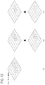
- FIG. 5 is a diagram showing a test result of image feature matching after filtering keyframe by an OTag.
- an upper view (a) corresponds to a result of selecting keyframes through image feature matching for all keyframes.
- a lower view (b) corresponds to a result of selecting keyframes through image feature matching among keyframes labeled with an OTag termed ‘cup’.
- the images on the left in the upper view (a) and the lower view (b) of FIG. 5 are keyframes selected as a result of the most matching keypoints for the camera input image of the user terminal on the right.
- the keyframe selection is performed at the user terminal, it is possible to search keyframes stored in the user terminal, including keyframes downloaded via communication with the server.
- the representative image of the user terminal may be transmitted to the server and the keyframes may be selected through the search of the keyframe at the server.
- the keyframes are transmitted to the user terminal, and selected by performing image feature matching with the current camera image of the user terminal.
- the keyframes in a group of reference targets are arranged in order of decreasing matching through keypoint matching.
- the matching levels are shown as forms of black bars ( 510 , 520 ) according to the number of keypoints.
- the lower view (b) has higher accuracy because some of keyframes labeled by the OTag termed ‘cup’ are filtered, and thus the keyframes are selected from among a small number of keyframes through keypoint matching, thereby improving the accuracy.
- FIG. 6 is a diagram showing a test result of image feature matching after filtering keyframe by an OTag.
- an upper view (a) corresponds to a result obtained after selecting keyframes from among all the keyframes.
- a lower view (b) corresponds to a result of image feature matching after selecting keyframes among keyframes labeled with an OTag pointing to a ‘monitor’.
- FIG. 7 is a diagram illustrating a method of performing image feature matching using a grid.
- the keyframe image is divided into grid areas in the keyframe according to GridXY information (e.g., 4 ⁇ 4, 6 ⁇ 6, 8 ⁇ 10, etc.) included in the first information.
- GridXY information e.g., 4 ⁇ 4, 6 ⁇ 6, 8 ⁇ 10, etc.
- FIG. 7 an 8 ⁇ 8 grid is used.
- the size of a grid cell may vary depending on the size of the image resolution.
- FIGS. 8 and 9 are diagrams illustrating a method of performing feature matching between the labeled keyframe and the image using weighted grid information
- weighted grid information included in the labeled keyframe it is possible to select the keyframe as the accuracy of keyframe selection is increased or the AR Apps execution time is ensured.
- a grid is used for weighted features (e.g., keypoint, feature line, feature object, etc.) is because the grid may be easily expressed in a simple bitmap format for a variety of resolutions, the distribution of features is easy to be known (e.g., feature comparison is difficult when keypoints are gathered in one place), and similar patterns are processed in parallel.
- a weighted grid is applied to the first object.
- the first object may be a grid area or object having characteristics that are considered to be an important factor in image feature matching.
- the first object may be selected by combining the movement information of the object in the image and the change information of the object. More specifically, the first object is to be matched on the basis of a feature that is important for the entire image or is not affected by environmental changes or temporal changes due to dynamic objects. This improves the accuracy and stability of matching. In FIG. 8 , a weight is given to buildings that are difficult to change easily.
- the weighted grid may be manually added by a service provider or a developer, and may be automatically assigned by a computer through comparison of a plurality of keyframes or recognition of an object.
- FIG. 8 although two is used as a weight relative to one, another number may be used.
- the importance of the keypoint (or feature line, feature object, etc.) detected in the grid area is represented according to the weight of the grid.
- each weight in each of grids is equal to one. In other words, it produces the same result as when the grids are not used.
- the correspondence between the keypoints in the camera input image and the keypoints in the keyframe is counted in a unit of one.
- a threshold value di as shown in FIG. 9 .
- the total number of keypoints in the image is N and the number of matched keypoints is Nm
- a ratio therebetween is greater than a predetermined value, that is, Nm/N>M
- each weight of a part of the grids is set to 2.
- the number of keypoints is 780 in (b) of FIG. 8 and fewer than 800 in (a) of FIG. 8 , the camera tracking is normally succeeded by the feature matching for the main object.
- the value of the weighted areas may be a value other than two.
- the feature matching may be performed for the target object to overlap 3D virtual objects.
- the accuracy of keypoint matching may be improved by adding the weight to a fixed object rather than the image feature generated by the change of the natural environment, the moving object, and the like.
- the method may also be extended to feature lines and feature objects in the grid area.
- weighted grids When applying the weighted grids, it is possible to repeatedly use weighted grids and non-weighted grids in a unit of a fixed time.
- the non-weighted grids are temporarily identified, thereby determining how much difference there is between the keyframes and the current camera image, and thus adjusting the weight value in the weighted grid.
- FIG. 10 is a diagram illustrating a grid mask whose weights are adjusted using an AR marker.
- the AR marker when an AR marker is assigned to a camera input image, the AR marker may be weighted automatically and recognized. It is possible to use an image texture or the like as the AR marker.
- the AR marker may be stored in a user terminal or server.
- the grid area for the AR marker may be manually specified by the user.
- Recognition may be stable when the weight value is added to a stationary and flat AR marker.
- FIG. 11 is a diagram illustrating a grid mask applied with multiple layers.
- the grid mask may be calculated in multiple layers.
- the L0 layer may correspond to a default weight.
- L1, . . . , and Lt may correspond to grid layers to which weights are applied for objects that are designated by the user or automatically designated.
- the maximum value of grid position value ⁇ x,y for layer Li other than L0 is calculated, thereby determining grid mask value ⁇ x,y to be finally applied.
- ⁇ x,y max( ⁇ 0,x,y , ⁇ 1,x,y , . . . ⁇ h,x,y ) [Equation 2]
- Each weight of each grid layer may be set for objects detected by the user or automatically. Using this approach, the weighted grid may be automatically stored through communication with the server.
- FIG. 12 is a diagram illustrating a soft grid mask.
- the grid scheme may also be used to guarantee the AR application execution speed.
- a performance of at least 20 FPS has to be guaranteed in an application such as a game
- a large number of features (keypoint, feature line, etc.) in the camera image requires a large amount of calculation, which may not guarantee the performance of 20 FPS.
- the grid mask information which may be expressed in forms of bits may be stored and used together with the keyframes.
- the selection criterion of some areas is such that feature matching is performed only for the areas having a higher weight value from the grid areas and processing of features with low importance is delayed, whereby quick calculation may be possible.
- a soft grid mask may refer to a modified grid mask that performs calculations only on partial grids.
- the grid mask may be partially used to enable high speed image feature matching by determining the grid to which the weighted grid is applied, which is referred to as a soft grid mask.
- the soft grid mask may be implemented as a form that calculates a certain range around weighted grid areas, a form that calculates only weighted grid areas, or a form that calculates only grid areas with high weights.
- the view (a) represents a soft grid mask calculating for a predetermined range around weighted grid areas; (b) represents a soft grid mask calculating for only the weighted grid areas; and (c) represents a soft grid mask calculating for only grid areas with higher weights.
- FIG. 13 is a diagram illustrating a method of applying a soft grid mask.
- new weight ⁇ ′ x,y of the soft grid mask is calculated.
- feature matching is performed between the labeled keyframes and the camera input image to select the keyframes, and the camera pose is calculated using the keyframes.
- the view (a) shows correction of weight values of the soft grid mask calculated for a predetermined range around weighted grid areas;
- (b) shows correction of a weight value of the soft grid mask calculated only for the weighted grid areas;
- (C) shows correction of weight values of the soft grid mask calculated for only grid areas having high weight value.
Landscapes
- Engineering & Computer Science (AREA)
- Theoretical Computer Science (AREA)
- Physics & Mathematics (AREA)
- General Physics & Mathematics (AREA)
- Multimedia (AREA)
- Computer Vision & Pattern Recognition (AREA)
- Software Systems (AREA)
- Signal Processing (AREA)
- Evolutionary Computation (AREA)
- Artificial Intelligence (AREA)
- Data Mining & Analysis (AREA)
- Databases & Information Systems (AREA)
- Computing Systems (AREA)
- Computational Linguistics (AREA)
- Medical Informatics (AREA)
- General Health & Medical Sciences (AREA)
- Health & Medical Sciences (AREA)
- Bioinformatics & Cheminformatics (AREA)
- Life Sciences & Earth Sciences (AREA)
- General Engineering & Computer Science (AREA)
- Bioinformatics & Computational Biology (AREA)
- Evolutionary Biology (AREA)
- Computer Networks & Wireless Communication (AREA)
- Image Analysis (AREA)
- Studio Devices (AREA)
Abstract
Description
(GPSu,x−GPSkf,x)2+(GPSu,y−GPSkf,y)2 <D GPS 2 [Equation 1]
υx,y=max(υ0,x,y,υ1,x,y, . . . υh,x,y) [Equation 2]
Δυ=argminυ
υ′x,y=max(υx,y−Δυ,0) (Equation 41
Claims (20)
Applications Claiming Priority (2)
| Application Number | Priority Date | Filing Date | Title |
|---|---|---|---|
| KR10-2018-0037686 | 2018-03-30 | ||
| KR1020180037686A KR102557049B1 (en) | 2018-03-30 | 2018-03-30 | Image Feature Matching Method and System Using The Labeled Keyframes In SLAM-Based Camera Tracking |
Publications (2)
| Publication Number | Publication Date |
|---|---|
| US20190304133A1 US20190304133A1 (en) | 2019-10-03 |
| US10970874B2 true US10970874B2 (en) | 2021-04-06 |
Family
ID=68054561
Family Applications (1)
| Application Number | Title | Priority Date | Filing Date |
|---|---|---|---|
| US16/370,550 Active 2039-07-16 US10970874B2 (en) | 2018-03-30 | 2019-03-29 | Method and apparatus for performing image feature matching using labeled keyframes in SLAM-based camera tracking |
Country Status (2)
| Country | Link |
|---|---|
| US (1) | US10970874B2 (en) |
| KR (1) | KR102557049B1 (en) |
Cited By (2)
| Publication number | Priority date | Publication date | Assignee | Title |
|---|---|---|---|---|
| US11360731B2 (en) * | 2017-03-30 | 2022-06-14 | Microsoft Technology Licensing, Llc | Sharing neighboring map data across devices |
| US12548322B2 (en) | 2021-10-18 | 2026-02-10 | Samsung Electronics Co., Ltd. | Electronic apparatus and method for identifying content |
Families Citing this family (17)
| Publication number | Priority date | Publication date | Assignee | Title |
|---|---|---|---|---|
| US9589000B2 (en) | 2012-08-30 | 2017-03-07 | Atheer, Inc. | Method and apparatus for content association and history tracking in virtual and augmented reality |
| CN111094893A (en) * | 2017-07-28 | 2020-05-01 | 高通股份有限公司 | Image sensor initialization for robotic vehicles |
| KR102457588B1 (en) * | 2019-12-13 | 2022-10-24 | 주식회사 케이티 | Autonomous robot, location estimation server of autonomous robot and location estimation or autonomous robot using the same |
| KR102383567B1 (en) | 2019-12-16 | 2022-04-06 | 네이버랩스 주식회사 | Method and system for localization based on processing visual information |
| KR20220111716A (en) * | 2019-12-20 | 2022-08-09 | 인터디지털 씨이 페이튼트 홀딩스, 에스에이에스 | Devices and methods for device localization |
| CN111239763A (en) * | 2020-03-06 | 2020-06-05 | 广州视源电子科技股份有限公司 | Object positioning method and device, storage medium and processor |
| CN111881819B (en) * | 2020-07-27 | 2025-01-03 | 北京融链科技有限公司 | Hydrogenation data processing method and device |
| CN112416278B (en) * | 2020-11-10 | 2021-12-03 | 北京五八信息技术有限公司 | Screen sharing method and device, electronic equipment and storage medium |
| KR102467858B1 (en) * | 2020-12-02 | 2022-11-17 | 서울대학교산학협력단 | Collaborative visual simultaneous localization and mapping system and method |
| CN113739813B (en) * | 2021-08-23 | 2026-03-17 | 东风悦享科技有限公司 | A multi-sensor fusion localization method, system, and device for autonomous vehicles. |
| US12483922B2 (en) * | 2022-10-26 | 2025-11-25 | Qualcomm Incorporated | Dynamic distributed extended reality compute |
| KR102731643B1 (en) * | 2022-12-21 | 2024-11-15 | 국립한밭대학교 산학협력단 | Slam system for predicting keypoints and its optimum speed control method |
| WO2025004918A1 (en) * | 2023-06-29 | 2025-01-02 | ソニーグループ株式会社 | Information processing device, information processing method, and information processing system |
| KR20250041962A (en) * | 2023-09-19 | 2025-03-26 | 삼성전자주식회사 | Method of simultaneous localization and mapping and electronic device perfroming thereof |
| KR20250053533A (en) * | 2023-10-13 | 2025-04-22 | 주식회사 큐픽스 | Method of Photo Localization Using Video Motion Analysis |
| US12470687B2 (en) | 2023-12-28 | 2025-11-11 | Samsung Electronics Co., Ltd. | System and method for correcting a mapping drift in an electronic device |
| WO2025143718A1 (en) * | 2023-12-28 | 2025-07-03 | Samsung Electronics Co., Ltd. | System and method for correcting a mapping drift in an electronic device |
Citations (15)
| Publication number | Priority date | Publication date | Assignee | Title |
|---|---|---|---|---|
| US20080215184A1 (en) | 2006-12-07 | 2008-09-04 | Electronics And Telecommunications Research Institute | Method for searching target object and following motion thereof through stereo vision processing and home intelligent service robot using the same |
| US7634336B2 (en) | 2005-12-08 | 2009-12-15 | Electronics And Telecommunications Research Institute | Localization system and method of mobile robot based on camera and landmarks |
| WO2014020318A1 (en) * | 2012-07-30 | 2014-02-06 | Sony Computer Entertainment Europe Limited | Localisation and mapping |
| KR101422084B1 (en) | 2014-05-16 | 2014-08-14 | (주)나인정보시스템 | Multi-viewpoint linked tracking system and method using particle filter in the object area detected by background modeling |
| US20160012588A1 (en) * | 2014-07-14 | 2016-01-14 | Mitsubishi Electric Research Laboratories, Inc. | Method for Calibrating Cameras with Non-Overlapping Views |
| US9367811B2 (en) * | 2013-03-15 | 2016-06-14 | Qualcomm Incorporated | Context aware localization, mapping, and tracking |
| KR20160119105A (en) | 2014-02-07 | 2016-10-12 | 퀄컴 테크놀로지스, 인크. | Live scene recognition allowing scene dependent image modification before image recording or display |
| KR20170126300A (en) | 2016-05-09 | 2017-11-17 | 오드컨셉 주식회사 | Method, apparatus and computer program for matching between the images |
| KR20180009180A (en) | 2016-07-18 | 2018-01-26 | 단국대학교 천안캠퍼스 산학협력단 | System and Method for Multi Object Tracking based on Reliability Assessment of Learning in Mobile Environment |
| US20180268237A1 (en) * | 2014-10-01 | 2018-09-20 | Apple Inc. | Method and system for determining at least one property related to at least part of a real environment |
| US20190080467A1 (en) * | 2017-09-08 | 2019-03-14 | Qualcomm Incorporated | Pose determination with semantic segmentation |
| US20190200154A1 (en) * | 2017-12-21 | 2019-06-27 | Facebook, Inc. | Systems and methods for audio-based augmented reality |
| US20200158517A1 (en) * | 2017-01-19 | 2020-05-21 | Mindmaze Holding Sa | System, methods, device and apparatuses for preforming simultaneous localization and mapping |
| US20200409376A1 (en) * | 2016-02-29 | 2020-12-31 | AI Incorporated | Obstacle recognition method for autonomous robots |
| US20200409387A1 (en) * | 2017-12-05 | 2020-12-31 | Sony Corporation | Image processing apparatus, image processing method, and program |
Family Cites Families (4)
| Publication number | Priority date | Publication date | Assignee | Title |
|---|---|---|---|---|
| US9674507B2 (en) | 2013-04-30 | 2017-06-06 | Qualcomm Incorporated | Monocular visual SLAM with general and panorama camera movements |
| US20140323148A1 (en) * | 2013-04-30 | 2014-10-30 | Qualcomm Incorporated | Wide area localization from slam maps |
| US9524434B2 (en) * | 2013-10-04 | 2016-12-20 | Qualcomm Incorporated | Object tracking based on dynamically built environment map data |
| US10185775B2 (en) | 2014-12-19 | 2019-01-22 | Qualcomm Technologies, Inc. | Scalable 3D mapping system |
-
2018
- 2018-03-30 KR KR1020180037686A patent/KR102557049B1/en active Active
-
2019
- 2019-03-29 US US16/370,550 patent/US10970874B2/en active Active
Patent Citations (15)
| Publication number | Priority date | Publication date | Assignee | Title |
|---|---|---|---|---|
| US7634336B2 (en) | 2005-12-08 | 2009-12-15 | Electronics And Telecommunications Research Institute | Localization system and method of mobile robot based on camera and landmarks |
| US20080215184A1 (en) | 2006-12-07 | 2008-09-04 | Electronics And Telecommunications Research Institute | Method for searching target object and following motion thereof through stereo vision processing and home intelligent service robot using the same |
| WO2014020318A1 (en) * | 2012-07-30 | 2014-02-06 | Sony Computer Entertainment Europe Limited | Localisation and mapping |
| US9367811B2 (en) * | 2013-03-15 | 2016-06-14 | Qualcomm Incorporated | Context aware localization, mapping, and tracking |
| KR20160119105A (en) | 2014-02-07 | 2016-10-12 | 퀄컴 테크놀로지스, 인크. | Live scene recognition allowing scene dependent image modification before image recording or display |
| KR101422084B1 (en) | 2014-05-16 | 2014-08-14 | (주)나인정보시스템 | Multi-viewpoint linked tracking system and method using particle filter in the object area detected by background modeling |
| US20160012588A1 (en) * | 2014-07-14 | 2016-01-14 | Mitsubishi Electric Research Laboratories, Inc. | Method for Calibrating Cameras with Non-Overlapping Views |
| US20180268237A1 (en) * | 2014-10-01 | 2018-09-20 | Apple Inc. | Method and system for determining at least one property related to at least part of a real environment |
| US20200409376A1 (en) * | 2016-02-29 | 2020-12-31 | AI Incorporated | Obstacle recognition method for autonomous robots |
| KR20170126300A (en) | 2016-05-09 | 2017-11-17 | 오드컨셉 주식회사 | Method, apparatus and computer program for matching between the images |
| KR20180009180A (en) | 2016-07-18 | 2018-01-26 | 단국대학교 천안캠퍼스 산학협력단 | System and Method for Multi Object Tracking based on Reliability Assessment of Learning in Mobile Environment |
| US20200158517A1 (en) * | 2017-01-19 | 2020-05-21 | Mindmaze Holding Sa | System, methods, device and apparatuses for preforming simultaneous localization and mapping |
| US20190080467A1 (en) * | 2017-09-08 | 2019-03-14 | Qualcomm Incorporated | Pose determination with semantic segmentation |
| US20200409387A1 (en) * | 2017-12-05 | 2020-12-31 | Sony Corporation | Image processing apparatus, image processing method, and program |
| US20190200154A1 (en) * | 2017-12-21 | 2019-06-27 | Facebook, Inc. | Systems and methods for audio-based augmented reality |
Non-Patent Citations (1)
| Title |
|---|
| Raul Mur-Artal et al., "ORB-SLAM: A Versatile and Accurate Monocular SLAM System", IEEE Transactions on Robotics, Oct. 2015, pp. 1147-1163, vol. 31, No. 5. |
Cited By (2)
| Publication number | Priority date | Publication date | Assignee | Title |
|---|---|---|---|---|
| US11360731B2 (en) * | 2017-03-30 | 2022-06-14 | Microsoft Technology Licensing, Llc | Sharing neighboring map data across devices |
| US12548322B2 (en) | 2021-10-18 | 2026-02-10 | Samsung Electronics Co., Ltd. | Electronic apparatus and method for identifying content |
Also Published As
| Publication number | Publication date |
|---|---|
| US20190304133A1 (en) | 2019-10-03 |
| KR20190114652A (en) | 2019-10-10 |
| KR102557049B1 (en) | 2023-07-19 |
Similar Documents
| Publication | Publication Date | Title |
|---|---|---|
| US10970874B2 (en) | Method and apparatus for performing image feature matching using labeled keyframes in SLAM-based camera tracking | |
| US20230245449A1 (en) | Terminal device, information processing device, object identifying method, program, and object identifying system | |
| US20230199013A1 (en) | Attack situation visualization device, attack situation visualization method and recording medium | |
| CN110853033B (en) | Video detection method and device based on inter-frame similarity | |
| US8977055B2 (en) | Information processing device, object recognition method, program, and terminal device | |
| CN111046125A (en) | Visual positioning method, system and computer readable storage medium | |
| US10636190B2 (en) | Methods and systems for exploiting per-pixel motion conflicts to extract primary and secondary motions in augmented reality systems | |
| CN107369183A (en) | Towards the MAR Tracing Registration method and system based on figure optimization SLAM | |
| Li et al. | Improving OpenStreetMap missing building detection using few‐shot transfer learning in sub‐Saharan Africa | |
| CN111666922A (en) | Video matching method and device, computer equipment and storage medium | |
| KR20210032678A (en) | Method and system for estimating position and direction of image | |
| US12323878B2 (en) | Road side positioning method and apparatus, device, and storage medium | |
| US20200065629A1 (en) | Method for location inference from map images | |
| CN111160307A (en) | Face recognition method and face recognition card punching system | |
| CN111931720A (en) | Method, apparatus, computer device and storage medium for tracking image feature points | |
| CN112862730A (en) | Point cloud feature enhancement method and device, computer equipment and storage medium | |
| WO2023087758A1 (en) | Positioning method, positioning apparatus, computer-readable storage medium, and computer program product | |
| CN114972465A (en) | Image target depth detection method and device, electronic equipment and storage medium | |
| Wang et al. | BevSplat: Resolving height ambiguity via feature-based Gaussian primitives for weakly-supervised cross-view localization | |
| CN110414845B (en) | Risk assessment methods and devices for target transactions | |
| CN108564045A (en) | Data processing method, device, storage medium and the computer equipment of augmented reality | |
| JP7781029B2 (en) | Change detection system, change detection method, and change detection program | |
| KR20220059054A (en) | Method for providing augmented reality content based on update of feature map and apparatus using the same | |
| KR20240002188A (en) | Apparatus and method for visual localization | |
| CN105830095B (en) | Ratings and recommendations for selecting augmented reality markers |
Legal Events
| Date | Code | Title | Description |
|---|---|---|---|
| AS | Assignment |
Owner name: ELECTRONICS AND TELECOMMUNICATIONS RESEARCH INSTIT Free format text: ASSIGNMENT OF ASSIGNORS INTEREST;ASSIGNOR:BANG, JUN SEONG;REEL/FRAME:048745/0839 Effective date: 20190328 Owner name: ELECTRONICS AND TELECOMMUNICATIONS RESEARCH INSTITUTE, KOREA, REPUBLIC OF Free format text: ASSIGNMENT OF ASSIGNORS INTEREST;ASSIGNOR:BANG, JUN SEONG;REEL/FRAME:048745/0839 Effective date: 20190328 |
|
| FEPP | Fee payment procedure |
Free format text: ENTITY STATUS SET TO UNDISCOUNTED (ORIGINAL EVENT CODE: BIG.); ENTITY STATUS OF PATENT OWNER: SMALL ENTITY |
|
| FEPP | Fee payment procedure |
Free format text: ENTITY STATUS SET TO SMALL (ORIGINAL EVENT CODE: SMAL); ENTITY STATUS OF PATENT OWNER: SMALL ENTITY |
|
| STPP | Information on status: patent application and granting procedure in general |
Free format text: DOCKETED NEW CASE - READY FOR EXAMINATION |
|
| STPP | Information on status: patent application and granting procedure in general |
Free format text: NON FINAL ACTION MAILED |
|
| STPP | Information on status: patent application and granting procedure in general |
Free format text: RESPONSE TO NON-FINAL OFFICE ACTION ENTERED AND FORWARDED TO EXAMINER |
|
| STPP | Information on status: patent application and granting procedure in general |
Free format text: PUBLICATIONS -- ISSUE FEE PAYMENT RECEIVED |
|
| STPP | Information on status: patent application and granting procedure in general |
Free format text: PUBLICATIONS -- ISSUE FEE PAYMENT VERIFIED |
|
| STCF | Information on status: patent grant |
Free format text: PATENTED CASE |
|
| MAFP | Maintenance fee payment |
Free format text: PAYMENT OF MAINTENANCE FEE, 4TH YR, SMALL ENTITY (ORIGINAL EVENT CODE: M2551); ENTITY STATUS OF PATENT OWNER: SMALL ENTITY Year of fee payment: 4 |