US10936907B2 - Training a deep learning system for maritime applications - Google Patents
Training a deep learning system for maritime applications Download PDFInfo
- Publication number
- US10936907B2 US10936907B2 US16/537,706 US201916537706A US10936907B2 US 10936907 B2 US10936907 B2 US 10936907B2 US 201916537706 A US201916537706 A US 201916537706A US 10936907 B2 US10936907 B2 US 10936907B2
- Authority
- US
- United States
- Prior art keywords
- image
- images
- maritime
- objects
- training
- Prior art date
- Legal status (The legal status is an assumption and is not a legal conclusion. Google has not performed a legal analysis and makes no representation as to the accuracy of the status listed.)
- Expired - Fee Related
Links
Images


Classifications
-
- G06K9/6256—
-
- G—PHYSICS
- G05—CONTROLLING; REGULATING
- G05D—SYSTEMS FOR CONTROLLING OR REGULATING NON-ELECTRIC VARIABLES
- G05D1/00—Control of position, course, altitude or attitude of land, water, air or space vehicles, e.g. using automatic pilots
- G05D1/02—Control of position or course in two dimensions
- G05D1/0206—Control of position or course in two dimensions specially adapted to water vehicles
-
- G—PHYSICS
- G06—COMPUTING OR CALCULATING; COUNTING
- G06F—ELECTRIC DIGITAL DATA PROCESSING
- G06F18/00—Pattern recognition
- G06F18/20—Analysing
- G06F18/21—Design or setup of recognition systems or techniques; Extraction of features in feature space; Blind source separation
- G06F18/214—Generating training patterns; Bootstrap methods, e.g. bagging or boosting
-
- G—PHYSICS
- G06—COMPUTING OR CALCULATING; COUNTING
- G06N—COMPUTING ARRANGEMENTS BASED ON SPECIFIC COMPUTATIONAL MODELS
- G06N3/00—Computing arrangements based on biological models
- G06N3/004—Artificial life, i.e. computing arrangements simulating life
- G06N3/006—Artificial life, i.e. computing arrangements simulating life based on simulated virtual individual or collective life forms, e.g. social simulations or particle swarm optimisation [PSO]
-
- G—PHYSICS
- G06—COMPUTING OR CALCULATING; COUNTING
- G06N—COMPUTING ARRANGEMENTS BASED ON SPECIFIC COMPUTATIONAL MODELS
- G06N3/00—Computing arrangements based on biological models
- G06N3/02—Neural networks
- G06N3/04—Architecture, e.g. interconnection topology
-
- G—PHYSICS
- G06—COMPUTING OR CALCULATING; COUNTING
- G06N—COMPUTING ARRANGEMENTS BASED ON SPECIFIC COMPUTATIONAL MODELS
- G06N3/00—Computing arrangements based on biological models
- G06N3/02—Neural networks
- G06N3/04—Architecture, e.g. interconnection topology
- G06N3/045—Combinations of networks
-
- G—PHYSICS
- G06—COMPUTING OR CALCULATING; COUNTING
- G06N—COMPUTING ARRANGEMENTS BASED ON SPECIFIC COMPUTATIONAL MODELS
- G06N3/00—Computing arrangements based on biological models
- G06N3/02—Neural networks
- G06N3/04—Architecture, e.g. interconnection topology
- G06N3/0464—Convolutional networks [CNN, ConvNet]
-
- G—PHYSICS
- G06—COMPUTING OR CALCULATING; COUNTING
- G06N—COMPUTING ARRANGEMENTS BASED ON SPECIFIC COMPUTATIONAL MODELS
- G06N3/00—Computing arrangements based on biological models
- G06N3/02—Neural networks
- G06N3/04—Architecture, e.g. interconnection topology
- G06N3/048—Activation functions
-
- G—PHYSICS
- G06—COMPUTING OR CALCULATING; COUNTING
- G06N—COMPUTING ARRANGEMENTS BASED ON SPECIFIC COMPUTATIONAL MODELS
- G06N3/00—Computing arrangements based on biological models
- G06N3/02—Neural networks
- G06N3/08—Learning methods
-
- G—PHYSICS
- G06—COMPUTING OR CALCULATING; COUNTING
- G06N—COMPUTING ARRANGEMENTS BASED ON SPECIFIC COMPUTATIONAL MODELS
- G06N3/00—Computing arrangements based on biological models
- G06N3/02—Neural networks
- G06N3/08—Learning methods
- G06N3/082—Learning methods modifying the architecture, e.g. adding, deleting or silencing nodes or connections
-
- G—PHYSICS
- G06—COMPUTING OR CALCULATING; COUNTING
- G06N—COMPUTING ARRANGEMENTS BASED ON SPECIFIC COMPUTATIONAL MODELS
- G06N3/00—Computing arrangements based on biological models
- G06N3/02—Neural networks
- G06N3/08—Learning methods
- G06N3/088—Non-supervised learning, e.g. competitive learning
-
- G—PHYSICS
- G06—COMPUTING OR CALCULATING; COUNTING
- G06N—COMPUTING ARRANGEMENTS BASED ON SPECIFIC COMPUTATIONAL MODELS
- G06N3/00—Computing arrangements based on biological models
- G06N3/02—Neural networks
- G06N3/08—Learning methods
- G06N3/09—Supervised learning
-
- G—PHYSICS
- G06—COMPUTING OR CALCULATING; COUNTING
- G06N—COMPUTING ARRANGEMENTS BASED ON SPECIFIC COMPUTATIONAL MODELS
- G06N3/00—Computing arrangements based on biological models
- G06N3/02—Neural networks
- G06N3/08—Learning methods
- G06N3/092—Reinforcement learning
-
- G—PHYSICS
- G06—COMPUTING OR CALCULATING; COUNTING
- G06N—COMPUTING ARRANGEMENTS BASED ON SPECIFIC COMPUTATIONAL MODELS
- G06N3/00—Computing arrangements based on biological models
- G06N3/02—Neural networks
- G06N3/08—Learning methods
- G06N3/096—Transfer learning
-
- G—PHYSICS
- G06—COMPUTING OR CALCULATING; COUNTING
- G06T—IMAGE DATA PROCESSING OR GENERATION, IN GENERAL
- G06T11/00—Two-dimensional [2D] image generation
- G06T11/40—Filling planar surfaces by adding surface attributes, e.g. adding colours or textures
-
- G—PHYSICS
- G06—COMPUTING OR CALCULATING; COUNTING
- G06T—IMAGE DATA PROCESSING OR GENERATION, IN GENERAL
- G06T7/00—Image analysis
- G06T7/10—Segmentation; Edge detection
- G06T7/194—Segmentation; Edge detection involving foreground-background segmentation
-
- G—PHYSICS
- G06—COMPUTING OR CALCULATING; COUNTING
- G06T—IMAGE DATA PROCESSING OR GENERATION, IN GENERAL
- G06T7/00—Image analysis
- G06T7/50—Depth or shape recovery
-
- G—PHYSICS
- G06—COMPUTING OR CALCULATING; COUNTING
- G06V—IMAGE OR VIDEO RECOGNITION OR UNDERSTANDING
- G06V10/00—Arrangements for image or video recognition or understanding
- G06V10/70—Arrangements for image or video recognition or understanding using pattern recognition or machine learning
- G06V10/82—Arrangements for image or video recognition or understanding using pattern recognition or machine learning using neural networks
-
- G—PHYSICS
- G06—COMPUTING OR CALCULATING; COUNTING
- G06V—IMAGE OR VIDEO RECOGNITION OR UNDERSTANDING
- G06V20/00—Scenes; Scene-specific elements
-
- G—PHYSICS
- G06—COMPUTING OR CALCULATING; COUNTING
- G06N—COMPUTING ARRANGEMENTS BASED ON SPECIFIC COMPUTATIONAL MODELS
- G06N3/00—Computing arrangements based on biological models
- G06N3/02—Neural networks
- G06N3/04—Architecture, e.g. interconnection topology
- G06N3/047—Probabilistic or stochastic networks
-
- G—PHYSICS
- G06—COMPUTING OR CALCULATING; COUNTING
- G06T—IMAGE DATA PROCESSING OR GENERATION, IN GENERAL
- G06T2207/00—Indexing scheme for image analysis or image enhancement
- G06T2207/10—Image acquisition modality
- G06T2207/10004—Still image; Photographic image
- G06T2207/10012—Stereo images
-
- G—PHYSICS
- G06—COMPUTING OR CALCULATING; COUNTING
- G06T—IMAGE DATA PROCESSING OR GENERATION, IN GENERAL
- G06T2207/00—Indexing scheme for image analysis or image enhancement
- G06T2207/20—Special algorithmic details
- G06T2207/20081—Training; Learning
-
- G—PHYSICS
- G06—COMPUTING OR CALCULATING; COUNTING
- G06T—IMAGE DATA PROCESSING OR GENERATION, IN GENERAL
- G06T2207/00—Indexing scheme for image analysis or image enhancement
- G06T2207/20—Special algorithmic details
- G06T2207/20228—Disparity calculation for image-based rendering
-
- G—PHYSICS
- G06—COMPUTING OR CALCULATING; COUNTING
- G06T—IMAGE DATA PROCESSING OR GENERATION, IN GENERAL
- G06T2207/00—Indexing scheme for image analysis or image enhancement
- G06T2207/30—Subject of image; Context of image processing
- G06T2207/30248—Vehicle exterior or interior
- G06T2207/30252—Vehicle exterior; Vicinity of vehicle
- G06T2207/30261—Obstacle
Definitions
- the disclosure generally relates to autonomous vehicles. More particularly the disclosure generally relates to systems and methods for controlling maritime vessels.
- Certain features have been included in automobiles, such as lane detection and lane centering. However, such applications lack the ability to sense features a maritime vessel may encounter. Further, unlike an automobile, a maritime vessel requires the ability to navigate with or without any external landmarks or objects.
- the image dataset in the maritime space is very sparse. Most of the time it is plain water with short bursts of activities that involve other solid objects around. Designers cannot use a traditional approach that assumes the dataset is evenly distributed among all categories of interest. Doing so will cause a biased neural network that will almost always predict that the scene has plain water in sight. An analogy could be if a neural network that is meant to diagnose cancer from the scan report could always give a negative result and still could be 99% accurate because most of the patients who take a precautionary scan do not have cancer, but the neural network would be rendered useless. Similarly, a neural network trained on an unaltered maritime dataset will always detect every scene as water and would still be 99% accurate but it would likely be unusable for its intended purpose. Eliminating water bias would be beneficial for training a neural network or other artificial intelligence in the maritime space.
- sets of images are used to train artificial intelligence that operate vehicles, such as boats or cars.
- the image sets are made up of images easily found on the internet. Images of roads or open water only include the most common vehicles. The image sets can include many variations of common cars, trucks, and motorcycles on roads and many variations of common sailboats and cargo ships on the water. However, there are limited images available for more obscure vehicles. If a designer wants to train artificial intelligence to recognize double-decker London buses, motorized trikes, or motorized rickshaws, then a U.S.-based image search is unlikely to provide many examples. Similarly, if a designer wants to train artificial intelligence to recognize dragon boats, dhows, or longships on the ocean, then that U.S.-based image search also is unlikely to provide many examples.
- a method is provided in a first embodiment.
- the method comprises training, using a processor, an object detection network with training images to identify and classify objects in images from a sensor system disposed on a maritime vessel. Objects in the images are identified and classified using the processor in an offline mode. Heat maps are generated in the offline mode. Instructions regarding operation of the maritime vessel are sent using the processor based on the objects that are identified. The instructions include a speed or a heading.
- the method can further comprise training, using the processor, the object detection network to send the instructions regarding operation of the maritime vessel based on the objects that are identified.
- the object detection network can be configured to determine an object depth estimate using the processor.
- the object depth can be determined by predicting a disparity map and obtaining the object depth.
- the objects can include a seashore, a watercraft, an iceberg, a static far object, a moving far object, or plain sea.
- the watercraft can include a personal non-powered vessel, recreational powered vessel, sailing yacht, cargo ship, cruise ship, coast guard boat, naval vessel, barge, tugboat, fishing vessel, workboat, under-powered vessel, or anchored vessel.
- Deduplication of the training images using hash outputs can be performed prior to the training.
- the training images can be determined by receiving an initial image of a maritime object at a processor and changing water conditions, sky conditions, and/or light conditions in the image of the maritime object to generate one of the training images using the processor.
- a non-transitory computer readable medium storing a program can be configured to instruct a processor to execute the identifying, the classifying, the generating, and the sending of the first embodiment.
- An object detection network can be configured to be trained using the method of the first embodiment.
- a method is provided in a second embodiment.
- the method comprises receiving an image of a maritime object at a processor and changing water conditions, sky conditions, and/or light conditions in the image of the maritime object to generate a second image using the processor.
- An object detection network can be trained using the second image.
- a plurality of the second image are generated.
- Each of the plurality of the second images has a different one of the water conditions, the sky conditions, or the light conditions.
- Deduplication of the second images can be performed using hash outputs prior to the training.
- the method can further include receiving a background image with the water conditions, the sky conditions, and/or the light conditions to be used in the second image.
- the method can further include generating a mask for the image of the maritime object, synthesizing a background, and blending the background and the image of the maritime object to form the second image.
- the changing can further include blending a region of the image of the maritime object with a region of a background image.
- the changing can further include determining a gradient field of the image of the maritime object.
- the changing can further include determining a gradient field of a background image.
- the changing can further include determining a gradient field of the second image fusing the image of the maritime object and the background image.
- the changing can further include determining divergence of the second image.
- the changing can further include determining a solution for a coefficient matrix.
- the processor may be in electronic communication with a data server.
- the data server can provide the image of the maritime object.
- a non-transitory computer readable medium storing a program can be configured to instruct a processor to execute the method of the second embodiment.
- An artificial intelligence module can be configured to be trained using the second image generated by the method of the second embodiment.
- FIG. 1 is a flowchart of an embodiment of a method in accordance with the present disclosure
- FIG. 2 is a chart showing exemplary object classification in accordance with the present disclosure
- FIG. 3 illustrates exemplary image recognition in accordance with the present disclosure
- FIG. 4 is a diagram of a situational awareness system in accordance with the present disclosure.
- FIG. 5 is a diagram of an operational embodiment in accordance with the present disclosure.
- FIG. 6 is a flowchart of a situational awareness system in accordance with the present disclosure.
- FIG. 7 is an exemplary image and depth map illustrating depth estimation
- FIG. 8 illustrates object depth determination
- FIG. 9A is a block diagram of a system in accordance with the present disclosure.
- FIG. 9B illustrates exemplary data collection and hardware connections
- FIG. 10 is a diagram showing a high-level architecture in accordance with the present disclosure.
- FIG. 11 illustrates an exemplary data collection plan
- FIG. 12 is a diagram of a data pipeline
- FIG. 13 is a diagram related to log files
- FIG. 14 is another diagram related to log files
- FIG. 15 illustrates a neural network for ship classifier type 2 (SCT2)
- FIG. 16 is a diagram showing an individual neural network's lifecycle
- FIG. 17 is a diagram showing a training network, exemplified in an inception Resnet V2 network.
- FIG. 18 is a flowchart of an embodiment in accordance with the present disclosure.
- FIG. 19 illustrates an exemplary gradient field of an image
- FIG. 20 illustrates an exemplary gradient field of a background image
- FIG. 21 illustrates a gradient field of a fused image
- FIG. 22 is an exemplary coefficient matrix
- FIG. 23 is another exemplary coefficient matrix
- FIG. 24 is a flowchart of another embodiment in accordance with the present disclosure.
- FIG. 25 is an exemplary network architecture diagram
- FIG. 26 is a flowchart of a deduplication embodiment in accordance with the present disclosure.
- FIG. 27 is a flowchart of an embodiment of image annotation in accordance with the present disclosure.
- Embodiments disclosed herein include systems, methods, and apparatuses for training deep learning and intelligent sensing system integration for autonomous ships.
- An object detection network which can include a convolutional neural network (CNN), can be trained to identify and classify objects in a real-time offline environment.
- the object detection network can be trained to operate a maritime vessel.
- Maritime objects can be identified and classified using the object detection network.
- the system can identify objects such as seashore, boats, ships, navigation safety hazards, icebergs, plain sea, and other maritime objects in real-time from the image feed received from cameras, RADARs, and/or the output from LIDARs.
- the system may further collect data including water current, wave height, wind velocity, water depth, distance from a static object, distance from a different maritime vessel, type of the moving vessel, and the velocity of the maritime vessel and other maritime vessel.
- the system's maritime navigation map can be aided using an object detection network.
- the object detection network can be used to recognize various types of vessels and objects around the vessel, which can enable navigation in accordance with COLREGS.
- Object depth estimation using deep learning (e.g., the object detection network) on stereoscopic images can predict the context of the stereoscopic output disparity map and improve distance perception of various objects in the environment, for example, by obtaining the depth.
- FIG. 1 illustrates the method 100 of training an algorithm for controlling a maritime vessel.
- the method may include a series of steps, which may be conducted in an exemplary order, or in a different order as necessary for performing the method. Some or all of the steps of the method may be performed in an offline mode.
- a non-transitory computer readable medium can store a program configured to instruct a processor to execute some or all of an embodiment of the method 100 .
- a CNN (such as a CNN in the object detection network) is trained to identify and classify objects in stereo images with a set of training images.
- the training images can be provided to the CNN from a storage medium, such as a server.
- the CNN is optionally trained to send instructions regarding operation of a maritime vessel.
- the CNN is optionally configured at to identify and classify objects in stereo images that are received from a sensor system.
- the CNN is optionally configured at to send instructions regarding operation of the maritime vessel based on the objects that are identified.
- the method may further include identifying objects in the plurality of images. Identification 102 may be performed in an offline mode.
- the objects can include, for example, a seashore, a watercraft, an iceberg, a canal entrance, a lock gate, a bridge, a static far object, a moving far object, plain sea, or other objects.
- the watercraft can include a personal non-powered vessel, recreational powered vessel, sailing yacht, cargo ship, cruise ship, coast guard boat, naval vessel, barge, tugboat, fishing vessel, workboat, under-powered vessel, anchored vessel, or other vessels.
- the objects can also include people and other navigation safety hazards.
- FIG. 2 is a chart showing exemplary object classification.
- FIG. 3 illustrates exemplary image recognition results.
- the method 100 may include receiving a plurality of images from a sensor system.
- the plurality of images may be received via stereo feeds, and the images may be created by transforming frames or parts of the stereo feed into images. Images may be produced from the devices, such as other cameras or thermal cameras, and fused into a single or multiple output disparity maps.
- the method may further include classifying objects in the images.
- Classification 103 may be performed in an offline mode.
- a dataset can be collected by capturing images using multiple cameras attached to the ships.
- the images are classified using labels including, inter alia, powered boat, sailing yacht, cargo ship, cruise ship, coast guard boat, naval vessel, lock bridge, normal bridge, static far object, moving far object, icebergs, and shore.
- the different categories into which the dataset is to be labeled are described above. Given any image, the image is classified into one of the above categories. In addition, if there is an overlap between categories, classifying an image into one of the two categories is sufficient.
- images can be received by a trained neural network, such as an object detection network, image segmentation network, and object identification network.
- the neural network can be trained on the cloud. However, once trained, the neural network binary can be deployed to an offline system to identify objects across particular categories or classify the entire image.
- the neural network can provide a bounding box (e.g., x cross y) or other graphical shape (two-dimensional or three-dimensional) around an object in an image, which can size the object in the image using various methods, which may include using the diagonal length of the shape to infer size.
- the neural network also can provide a classification of the object in the bounding box with a confidence score.
- Training a self-driving vessel to eliminate false positives can be a challenge. Since the decisions in maritime navigation are typically taken in advance when compared to the navigation of a car on the road, objects need to be identified at a distance. Identifying objects accurately at a distance is a challenge. In order to do so, we could create superficial categories like “Far Static Object” or “Far Moving Object” when they are detected at a distance and refine them to their actual categories like a “buoy” or a “canoe” when they get close enough for accurate classification.
- Data can be taken during different times of the year in different places.
- the system that collects data and the system responsible for navigating the ship are same, errors can be eliminated.
- errors can be eliminated.
- the apparatus used to gather machine learning data is the same one that is deployed after the training is completed.
- the same sensors can be installed in similar positions and orientations in any given vessel.
- FIG. 3 illustrates exemplary images having confidence scores determined.
- objects in image 301 may be classified, yielding scored results of 0.99535 for “iceberg,” 0.00358 for “ocean,” and 0.00108 for “boatship.”
- Objects in image 302 may be classified, yielding scored results of 0.00255 for “iceberg,” 0.97706 for “ocean,” and 0.02040 for “boatship.”
- Objects in image 303 may be classified, yielding scored results of 0.00701 for “iceberg,” 0.00162 for “ocean,” and 0.99137 for “boatship.”
- Objects in image 304 may be classified, yielding scored results of 0.20249 for “iceberg,” 0.79449 for “ocean,” and 0.00302 for “boatship.”
- the identification and the classification can include using a CNN in the form of an object detection network, image segmentation network, or an object identification network.
- a CNN or other deep learning module in the object determination network can be trained with at least one set of images.
- a CNN is a type of feed-forward artificial neural network in which the connectivity pattern between its neurons (i.e., pixel clusters) is inspired by the organization of the animal visual cortex. Individual cortical neurons respond to stimuli in a restricted region of space known as the receptive field. The receptive fields of different neurons partially overlap such that they tile the visual field. The response of an individual neuron to stimuli within its receptive field can be approximated mathematically by a convolution operation. CNNs are discussed in more detail later herein.
- the object classification network can perform operations like a scene classifier.
- the object classification network can take in an image frame and classify it into only one of the categories.
- An example of this includes receiving an input from the cameras and classifying the inputs as that of nighttime images or that of a heavy sea state.
- three neural networks may be used.
- One neural network identifies objects in images, one neural network segments the image into regions that need to be classified, and another neural network classifies objects identified by the first neural network.
- Three neural networks may provide improved object detection speed.
- Three neural networks also can classify the whole scene in the image, including time of the day (e.g., dawn, dusk, night), the state of the vessels, if vessels in front are moving or static, and/or classify the watercraft or other objects identified by the object detection network.
- two neural networks may be used.
- One neural network identifies objects in images and another neural network classifies objects identified by the first neural network.
- Two neural networks may provide improved object detection speed.
- Two neural networks also can classify the whole scene in the image, including time of the day (e.g., dawn, dusk, night), if vessels in front are moving or static, and/or classify the watercraft or other objects identified by the object detection network.
- a single neural network may identify objects in an image and classify these objects.
- a second validation neural network can optionally be used for verification of the identification and classification steps. Use of a single neural network may provide sufficient results to operate a vessel.
- the method may further include sending instructions regarding operation of the maritime vessel based on the objects identified.
- the instructions can enable navigation in accordance with COLREGS and any other navigation safety procedures imposed locally by an inland navigation authority, such as a port or river authority.
- the instructions may include, inter alia, an instruction to adjust a speed or a heading of the maritime vessel. Instructions may alternatively, or also, include instructions to adjust propeller pitch, a bow thruster, a stern thruster, an azimuth thruster, the state of anchoring, the state of mooring, or the position of a rudder of a larger maritime vessel.
- the instructions may include instructions to adjust the main thruster, azimuth thruster, pitch of a motor, or a rudder. Additionally, instructions may include suggestions to a pilot, helmsman, or captain to make any of these adjustments.
- the instructions to operate the vessel may not be provided by the object detection network. Rather, a separate algorithm may be used to send the instructions.
- the object detection network may provide weights to a grid over a nautical map, which may include a three-dimensional map constructed with LIDAR, RADAR, automatic identification system (AIS), and/or camera inputs via sensor fusion, which can then be used to make path or route changes.
- RADAR Radar
- LIDAR LIDAR
- compass heading GPS
- other camera feeds Sonar
- vessel specifications safety alerts or bulletins
- information from neighboring vessels sea conditions (e.g., tide, swells, etc.)
- anemometer bolometer
- ultrasound proximity sensor microphone
- weather reports e.g., wind speed, weather bulletins or alerts, or long-term weather forecasts
- the object detection network can use these inputs to determine instructions.
- the method may further include performing stereoscopy.
- the stereoscopy may be performed in an offline mode.
- the stereoscopy may include the process of creating an input disparity map, which may use a CNN to interpret and adjust the map based on context in the scene. In this way, the stereoscopy can be used for depth estimation or distance estimation.
- Two or more cameras may be used to perform stereoscopy, with appropriate lensing and inter-focal length.
- the method may further include generating heat maps.
- the heat maps may be generated in an offline mode. Overlapping heat zones created by the 3D image on the navigation map may be used to determine route feasibility.
- the heat map generation can be optimized to run with GPUs.
- a neural network that generates heat maps can be trained with marine application datasets. Cameras can provide image data for the heat maps, and may provide images of objects at various distances from the maritime vessel.
- a multidimensional (e.g., a two-dimensional) grid map can contain navigation information.
- Each square in the grid has a weight.
- a higher weight may mean the vessel should try to avoid the square with more urgency.
- the path of the vessel can be modified depending on these weights.
- the weights can change dynamically based on objects that are identified and/or classified.
- a path-planning algorithm can be employed to determine the most feasible path based on the weights.
- the method may further include estimating object depth.
- the object depth may be estimated in an offline mode. Estimating the object depth may be accomplished by generating a disparity map and obtaining an object depth, which may be the object's distance from the vessel. This may involve inferring the distance of multiple objects in the environment. Training can be performed using techniques such as those disclosed in “Stereo Matching by Training a Convolutional Neural Network to Compare Image Patches” by Zbontar and LeCun (submitted 2015), the disclosure of which is incorporated by reference in its entirety.
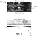
- FIG. 7 is an exemplary image 701 and depth map 702 illustrating depth estimation, wherein image 701 is turned into disparity map 702 to determine object depth.
- Disparity depth map 702 can use shading to depict how far the matter depicted in each pixel is from the camera.
- stereo matching can be used.
- a CNN can be trained to compare image patches for stereo matching.
- FIG. 8 illustrates object depth determination.
- Multiple stereo cameras can provide image input in the form of a visual sensor.
- a stereoscopic image pair can be used to obtain the depth information of objects in the image. This can help determine the distance of the other watercrafts from the maritime vessel being controlled by the processor in the embodiments disclosed herein.
- the visual sensor can be a monocular visual sensor, and may be paired with other sensors, such as LIDAR and/or RADAR.
- Matching cost computation can be performed.
- the solution can learn a similarity measure on small image patches using a CNN. Training is carried out in a supervised manner by constructing a binary classification data set with examples of similar and dissimilar pairs of patches. Experimentation on the algorithm may be needed to obtain the right balance between accuracy and speed needed for autonomous watercraft navigation. The output of the CNN can be used to initialize the stereo matching cost.
- a series of post-processing steps can then be performed: cross-based cost aggregation, semi-global matching, a left-right consistency check, subpixel enhancement, a median filter, and a bilateral filter. While post-processing steps can have drawbacks, post-processing steps may be necessary to achieve desired results. Matching costs can be combined between neighboring pixels with similar image intensities using cross-based cost aggregation. Smoothness constraints can be enforced by semi-global matching. A left-right consistency check can be used to detect and eliminate errors in occluded regions. Subpixel enhancement can be performed and a median filter and a bilateral filter can be applied to obtain the final disparity map.
- FIG. 8 illustrates depth estimation using stereoscopic images 801 and 802 and resulting in disparity map 802 via stereo matching, or stereoscopy.
- stereoscopic images may be, for example data from a monocular visual sensor paired with other sensors, such as LIDAR and/or RADAR.
- a CNN can be trained to compare image patches for stereo matching, or stereoscopy.
- the object depth can be determined by predicting disparity map 802 and obtaining the object depth. This can be performed using techniques such as those disclosed in “Stereo Matching by Training a Convolutional Neural Network to Compare Image Patches” by Zbontar and LeCun (submitted 2015), the disclosure of which is incorporated by reference in its entirety.
- an object depth estimation can be performed via deep learning (for example, the CNN in the object detection network) using stereoscopic images 801 and 802 to obtain the depth of each object in stereoscopic images 801 and 802 .
- the disparity map can use shading to depict how far the matter in each pixel is from the camera.
- the distances of one or more objects in an environment may also be inferred. This inference may be performed based on known properties of known objects.
- the method may further include determining a route feasibility, which can provide a determination of whether a path to a destination is feasible, and the route feasibility may be determined in an offline mode.
- the route feasibility may be determined based on a heat map.
- the method may further include generating a navigation policy.
- the navigation policy may be part of the instructions generated at 104 , or may be used to generate the instructions at 104 .
- generating a navigation policy may be part of determining route feasibility, or a generated navigation policy may be used to determine a route feasibility.
- the navigation policy may be generated in an offline mode. In an instance, a navigation policy may make a map appear infeasible if navigation is not possible.
- a navigation policy can keep a vessel compliant with COLREGS or other national or local navigation requirements, where applicable. Alternatively, different navigational requirements or liberties may be embedded in the navigation policy for, inter alia, navy or coast guard vessels.
- the determined route feasibility and generated navigation policy can be used for navigating complex routes. Where simpler routes are required, such as navigating between two points in a region lacking obstructions or objects, e.g., open sea, the mapping function may be avoided.
- the objects detected can include a variety of objects a maritime vessel may encounter. Such objects may include a seashore, a watercraft, an iceberg, a static far object, a moving far object, or plain sea.
- the watercraft may include a personal non-powered craft, a recreational powered craft, a sailing yacht, a cargo ship, a cruise ship, a coast guard boat, or a naval vessel.
- the objects may be identified and classified using an object detection network, which may employ machine learning.
- the machine learning may employ a CNN.
- FIG. 4 is a diagram of an example situational awareness system 400 in accordance with an embodiment.
- a map may display a vessel in proportionate size and show all other objects around it.
- the map may have zoom capability using two-finger expansion and/or contraction.
- the map may have a grid overlay function with options for changing grid size in the graphical user interface.
- the depth of the matter represented in each pixel on the map may be color coded. For example, depth greater than 80 feet may be light blue and gradually progress to darker shades of blue until those areas less than 40 feet in depth are black.
- Land may be represented as yellow, the vessel navigating may be light green, and other vessels may be red. As such, a two-dimensional grid map 402 is enabled.
- cameras may be prioritized for object classification and matched with AIS data.
- Camera data may be used to infer vessel status based on navigation light patterns and flags displayed by other vessels.
- a microphone may be used to detect honking by vessels alerting on their intention to make a particular maneuver.
- detection and ranging 404 , classification 405 , and the creation of the primary map 406 may occur.
- LIDAR and RADAR may be used to define contours of other objects in the map.
- LIDAR data may be prioritized over RADAR except, for example, during rain, snow, or fog. This is accomplished using LIDARs 408 , RADARs 409 , cameras 410 , AIS receiver 411 , microphone 412 , a marine traffic API 413 , a nautical chart 414 , and a satellite compass 415 .
- FIG. 5 is a diagram of an example operational embodiment 500 . Note the arrows between the localization 501 , mapping 502 , path-planning 503 , and actuation 504 steps. These iterations can repeat at a particular frequency. These iterations can continually change, and the frequency of the iteration can vary. For example, the iterations can change at a higher rate for objections or distances closer to the vessel. Thus, the frequency will be less at a distance farther from the vessel than more proximate the vessel.
- a GPS position is received.
- a current yaw, pitch, and roll of the vessel are determined.
- the vessel is also located on a nautical chart.
- mapping 502 the vessel and its trajectory based on current attitude is plotted on a nautical map.
- the map is populated with RADAR signatures.
- the map is populated with AIS messages, and populations are annotated using a vision sensor.
- constraints are defined based on populated areas. Constraints of future trajectories are added based on the current attitude of all populations. COLREG maneuver constraints are added based on annotations of the population.
- a path is determined based on A* path planning.
- A* path planning comprises the process of finding a path between multiple points/nodes.
- a difference between actual attitude and planned attitude is determined.
- the steering and thrust of the vessel are then actuated until the difference is minimized.
- FIG. 6 is a flowchart of an example situational awareness system 600 in accordance with an embodiment.
- a GPS position is obtained.
- a stored nautical chart for 10 ⁇ 10 nautical miles around the GPS position is obtained.
- static objects and depth information from the nautical chart may be used to populate the map.
- AIS receiver data for 10 ⁇ 10 nautical miles around the GPS position is obtained.
- the AIS receiver data is populated on the map. If internet access is available, at 606 , the map is compared with the local marine traffic authority's map and missing information is added to the map.
- LIDAR data is obtained and used to populate the map.
- RADAR data is obtained and used to populate the map.
- objects on the map are annotated based on camera data.
- duplicate objects are removed and error checks are run.
- a consolidated two-dimensional map is displayed on the monitors.
- a system in another embodiment, as illustrated in a system includes a sensor system and a processor for deep learning and intelligent sensing system integration for autonomous ships.
- the sensor system may be disposed on the maritime vessel and may be used to collect data used to navigate the maritime vessel.
- the data may be collected using a variety of inputs, and may include a plurality of images.
- Such inputs may include, inter alia, a stereoscopic camera, a RADAR system, or a compass.
- a stereoscopic camera as employed in some embodiments may include one or more individual camera systems configured to collect stereoscopic images.
- a stereoscopic camera as employed herein may include two or more lenses and one or more images using sensors configured to collect a stereogram by employing stereopsis. The distance to each point in the field of view can thus be determined based on calculating the disparity in position at each lens.
- the sensors that are deployed include a stereoscopic marine cameras, a satellite compass, a gyro compass, and/or RADAR.
- a router can be in electronic communication with the sensors. These particular components are merely examples, and other similar components can be used.
- a control unit or CNN may be in electronic communication with some or all of these sensors. The control unit or CNN also may be in electronic communication with other types of sensors.
- sensors can use customized marine communication protocols that are incompatible with a Windows and other PC operating systems. Therefore, these sensors can be integrated using third-party converters and drivers. Other types of software can be used instead of the software listed in this example.
- FIG. 9A is a block diagram of a system 200 .
- the CNN can be created and trained to identify and classify objects in a real time offline environment. In simple terms, the system can identify seashore, boats, ships, icebergs, plain sea and other possible maritime objects in real time based on an image feed from the cameras.
- Wind speed can be determined from an ultrasound anemometer or other devices. Other weather information can be transmitted to the processor.
- a processor may be in electronic communication with the sensor system 200 .
- the processor may be configured to receive a plurality of images from the sensor system and execute one or more of the steps of method 100 .
- An electronic storage device may be provided to store data used in the identification and classification.
- the dimensions, characteristics, or profiles of the objects may be stored thereon in a library of entries. Additional information that can be stored may include sensor readings, videos, measurements, navigation setting for the vessel, or other data. Such data may be encrypted and may include a digital signature. This data can be used to develop a profile of the vessel, for navigation, for training of personnel, for training of machine learning modules, or for other useful purposes. This data can also be used for example, for insurance claims or for other investigations.
- FIG. 9A is a block diagram of a system 200 and FIG. 9B is a diagram showing a high-level architecture in accordance with the present disclosure.
- the system 200 in FIG. 9A includes a control unit 205 , such as the control unit 205 seen in FIG. 9B .
- the control unit 205 includes a processor 202 and a memory 203 , and may be powered by power supply 910 .
- the control unit 205 is in electronic communication with sensors and other devices, represented by the box 201 . Such sensors may include marine stereo cameras 911 , RADAR 912 , satellite compass & GPS 913 , and gyro compass 914 .
- the control unit 205 also is in electronic communication with a maritime vessel control system 204 .
- the control unit 205 also may be in electronic communication with a power supply (not illustrated).
- the box 201 can include a sensor system disposed on the maritime vessel.
- the sensor system can include a pair of stereoscopic cameras, a RADAR system, and a compass.
- Other components, such as those disclosed herein, are possible.
- the processor 202 is configured to receive images from the sensor system, identify objects in the images in an offline mode, classify objects in the images in the offline mode, and send instructions regarding operation of the maritime vessel based on the objects that are identified.
- the processor 202 can send instructions to the maritime vessel control system 204 , which can control speed, steering, and other functions of the maritime vessel.
- the instructions can enable navigation in accordance with COLREGS.
- the processor 202 can be configured to perform stereoscopy, generate heat maps, and/or estimate object depth. These functions can be performed in an offline mode. Object depth can be estimated by predicting a disparity map and obtaining the object depth. The processor 202 also can be configured to infer the distance of multiple objects in an environment.
- the processor 202 can be configured to determine or predict route feasibility, which can be performed in an offline mode.
- the processor 202 can be configured to determine a navigation policy, which can be performed in an offline mode.
- the control unit 205 can include a deep learning module 206 (e.g., an object detection network module) and/or the processor 202 can be configured to operate a deep learning module 206 .
- the deep learning module 206 can be stored on the memory 203 .
- the processor 202 can include TensorFlow layers. One or more of receiving the identifying the objects, classifying the objects, and sending the instructions can be based on a CNN.
- the deep learning module 206 can include a CNN with other algorithms or software components before and/or after the CNN.
- Resnet can be used before or after the CNN.
- One or more of identifying the objects, classifying the objects, and sending the instructions includes training the CNN with a set of training images.
- the deep learning module 206 (e.g., the CNN module) can be trained.
- the deep learning module can be trained to identify and classify objects in images.
- the deep learning module 206 also can be trained to send instructions regarding operation of a maritime vessel, estimate distances or depths in stereo images, or develop a route for a maritime vessel.
- All videos from the various sensors can be converted to images and compared to other images.
- Unique images can be found. A degree of desired uniqueness can be tuned by adjusting a uniqueness factor. This can be used to generate a dataset. Most plain sea images can be removed from the dataset so that the dataset is not overwhelmed with open sea images. The number of open sea images may be approximately equal to the number of, for example, boat or iceberg images.
- the classification of the images in the training dataset can be verified.
- the processor 202 may be in communication with and/or include a memory 203 .
- the memory 203 can be, for example, a Random-Access Memory (RAM) (e.g., a dynamic RAM, a static RAM), a flash memory, a removable memory, and/or so forth.
- RAM Random-Access Memory
- instructions associated with performing the operations described herein can be stored within the memory 203 and/or a storage medium (which, in some embodiments, includes a database in which the instructions are stored) and the instructions are executed at the processor 202 .
- the memory 203 can include a library of entries.
- the processor 202 includes one or more modules and/or components.
- Each module/component executed by the processor 202 can be any combination of hardware-based module/component (e.g., a field-programmable gate array (FPGA), an application specific integrated circuit (ASIC), a digital signal processor (DSP)), software-based module (e.g., a module of computer code stored in the memory 203 and/or in the database, and/or executed at the processor), and/or a combination of hardware- and software-based modules.
- FPGA field-programmable gate array
- ASIC application specific integrated circuit
- DSP digital signal processor
- software-based module e.g., a module of computer code stored in the memory 203 and/or in the database, and/or executed at the processor
- Each module/component executed by the processor 202 is capable of performing one or more specific functions/operations as described herein.
- the modules/components included and executed in the processor 202 can be, for example, a process, application, virtual machine, and/or some other hardware or software module/component.
- the processor 202 can be any suitable processor configured to run and/or execute those modules/components.
- the processor 202 can be any suitable processing device configured to run and/or execute a set of instructions or code.
- the processor can be a general purpose processor, a central processing unit (CPU), an accelerated processing unit (APU), a field-programmable gate array (FPGA), an application specific integrated circuit (ASIC), a digital signal processor (DSP), and/or the like.
- the component(s), e.g., component(s) shown in FIG. 9A , executed by the processor 202 can include a deep learning module 206 (e.g., a CNN module configured to execute one or more of the steps of method 100 ).
- the processor 202 may further include a TensorFlow module configured to execute one or more of the steps of method 100 .
- the deep learning module 206 can have one of the configurations described further herein. Rooted in neural network technology, deep learning is a probabilistic graph model with many neuron layers, commonly known as a deep architecture. Deep learning technology processes the information such as image, text, voice, and so on in a hierarchical manner. In using deep learning in the present disclosure, feature extraction is accomplished automatically using learning from data. This is advantageous over previous approaches, which extract features based on experts' understanding of a set of images. For example, objects in images can be classified using the deep learning module based on the one or more extracted features.
- a non-transitory computer-readable storage medium may be configured to store a program that can instruct a processor to execute one or more of the steps of method 100 .
- Offline mode can mean that the control unit 205 or processor 202 does not rely on internet from outside the vessel.
- the control unit 205 or processor 202 may be connected to the vessel's Wi-Fi, which can provide connections to sensors, vessel systems, or other measurement devices. While the offline mode may not rely on internet from outside the vessel, this does not include GPS, AIS, or satellite compass data.
- the control unit 205 may cache the last data in offline mode, but can operate without an internet connection.
- Offline mode can be overcome by storing data locally onto the ships on, for example, 20 TB hard disks or other large storage units.
- the hard disks can be physically extracted when they reach the port.
- the data from all the ships can be uploaded onto the cloud and a series of pre-processing may be done to keep only one copy of a similar experience but keep all copies of unique experiences. Then the data may be sent for annotation.
- the neural network can be trained on the new set of data and the binary file is created which is deployed back onto the ship over the air when the ship is in port.
- a synchronizing software can update the cloud with the data present in the onboard hard disk.
- the Intel NUC computer present in the ship may be connected to the internet using a mobile internet dongle present in the ship and/or using ports' Wi-Fi when a ship docks for loading and/or unloading.
- FIG. 11 illustrates an example data collection plan. In this way, multiple vessels 1101 , 1102 , and 1103 having connections via port or mobile internet may communicate with a cloud server 1104 .
- FIG. 12 is a diagram of a data pipeline.
- the data collected by an Actisense Device is pushed to cloud storage from the on-board computer.
- the data pipeline processes this data from cloud storage and imports it into a platforms database, such as, for example, MongoDB, using, for example, Python and Bash scripts.
- a platforms database such as, for example, MongoDB
- Python and Bash scripts The whole process is described in FIG. 12 .
- the whole process can be invoked in a continuously running script in a virtual machine in a cloud computing system.
- Bash script For each log file in cloud storage, or other cloud computing system, the following happens as the Bash script is called.
- a file is downloaded from cloud storage to cloud computing using, for example, GoogleDriveAPI v3 for Python. This is done in Python Script 1.
- the downloaded log file is converted to JSON using CANBOAT's Analyzer. This is done in Python Script 2. Each data packet is checked with the previous packet if any of the same “msg_type.” If the new packet contains the same data as the previous packet it is ignored. If not it is added to a JSON file and set as the previous packet. Only the first occurring data packet of each second is considered for each “msg_type.” At the end of processing of the file the previous state is saved as a separate JSON and used for subsequent file. This is also done in Python Script 2. Using mongoimport the data in the JSON file created is loaded into the platforms database. All supporting files created are removed. Once all the files in cloud storage for the particular ship and pole are downloaded the Bash script sleeps for five minutes and looks for new files uploaded to cloud storage.
- FIG. 13 and FIG. 14 are diagrams related to log files.
- the logger can create log files with timestamp to milliseconds, so that querying the log files may be easier. Nested folders for day and hour can be created to better classify the files.
- the log files can be stored in cloud storage on a one way sync (e.g., Google File Stream).
- a branch of the pipeline can decode the NMEA network into JSON files and uploads into the local platforms database server (or other similar platforms or database programs) real time for the captain.
- the pipeline includes extracting NMEA data from a compass and redirecting it to Python to store it in a buffer.
- a subprocess is a library in Python that lets one run terminal commands, redirect the console output to a buffer in memory, and return a Python generator for that pointer.
- a generator lets one iterate over the console output once saving memory after iterating over an element.
- the NMEA logs are generated line by line and are stored in the buffer one per line. Since the logs can be generated infinitely, the program may run forever.
- the buffer variable may be known or available, so readline can be used to read once per line.
- a log file is created and the line is saved in a log file.
- Information can continue to be saved in a single file for up to, for example, one minute. After the minute is up, the file can be changed using the new timestamp and buffering can start into the new one. After an hour is up, folders are changed and new files are created there. After a day is up, a new folder above the current folders is created. The period to save to a single file or folder can vary, and the description herein is merely exemplary. The data may then be uploaded to cloud storage or another cloud storage service.
- NMEA data may be automatically saved into a dummy.log file whenever one line of NMEA data is obtained.
- a decoder may be run on the file. This can generate a JSON file with just one dictionary of data. This can be read back and timestamped.
- the file may be formatted and uploaded to the platform database or another location. This generates compass logs into the offline platform database (or other similar platforms or database programs). This process may take approximate one millisecond. This may be an acceptable time period because the compass does not generally generate data so fast that the buffer will fill up before one millisecond is up.
- one line of log is not saved to a file every time. Instead, the line of log is sent back into the Python buffer and saved in the platform database or another location. This can reduce the time by half, but may require a particular decoder configuration.
- the decoder may be a C++ application that runs in the command prompt.
- the code for these logs may be completely modular and run by functions.
- the code also may be reusable.
- the same code was used to classify RADAR data into Pcap files and upload it to cloud storage.
- the same code is used to classify the RADAR logs and timestamp it. This code was modified to change the terminal command to get the RADAR logs from the Ethernet network. To do this a command that captures network data is used.
- An application for example, a Java application, was developed that uses these RADAR files to create a view of the RADAR on an application.
- the RADAR logs are bigger than log files.
- the files were compressed.
- Gzip compression was used as a compression algorithm in one instance, but other compression algorithms can be used. Compression reduces the size of the Pcap files to be, for example, 10% the size of the original file in an efficient manner. Files may be compressed before uploading to cloud storage.
- Training data may be inputted to model training (e.g., CNN training), which may be performed in any suitable manner.
- the model training may include inputting the training data to the deep learning model (e.g., a CNN) and modifying one or more parameters of the model until the output of the model is the same as (or substantially the same as) the labels assigned to the data.
- Model training may generate one or more trained models, which may then be sent to model selection, which is performed using validation data.
- the results that are produced by each one or more trained models for the validation data that is input to the one or more trained models may be compared to the labels assigned to the validation data to determine which of the models is the best model. For example, the model that produces results that most closely match the validation data labels may be selected as the best model.
- Test data may then be used for model evaluation of the model that is selected (e.g., the best model).
- Model evaluation may be performed in any suitable manner.
- the test data may be input to the best model and the results produced by the best model for the test data may be compared to the labels for the test data to determine how closely the results produced by the best model match the labels.
- Best model may also be sent, to model deployment in which the best model may be sent to the maritime vessel for use (post-training mode). The best model may then be applied to additional images, data, output, etc. generated by or provided to the maritime vessel.
- reinforcement learning of the CNN is tuned.
- the CNN can learn settings on different objects and perform the same action.
- the CNN may need to learn each individual object because each of the ships or boats is unique and has unique performances.
- Reinforcement learning can be used to tune the actuators like thrusters, propellers, rudder, etc.
- the sensitivity of these components can change from ship to ship.
- the existing network can be retained with the new batch of images.
- the CNN can be trained with images that show a ship or boat that changes over time.
- Barnacles, wear-and-tear, and changes in fuel type can all affect operation or performance of a ship or boat.
- a synthetic data generator can be used to accommodate changes to the ship or boat over time. These changes also can be accommodated by modifying existing images in a library to show various changes as disclosed with respect to FIG. 18 .
- the vessel may identify and classify objects using deep learning techniques, such as one or more CNNs.
- TensorFlow's Inception network provides such a CNN.
- the configuration of a CNN may change based on the sensor information that is provided or the type of maritime vessel.
- Deep learning also known as deep structured learning, hierarchical learning or deep machine learning
- Deep learning is a branch of machine learning based on a set of algorithms that attempt to model high-level abstractions in data.
- the input layer receives an input, it passes on a modified version of the input to the next layer.
- Deep learning is part of a broader family of machine learning methods based on learning representations of data.
- An observation e.g., an image
- An observation can be represented in many ways such as a vector of intensity values per pixel, or in a more abstract way as a set of edges, regions of particular shape, etc. Some representations are better than others at simplifying the learning task (e.g., face recognition or facial expression recognition.
- Deep learning can provide efficient algorithms for unsupervised or semi-supervised feature learning and hierarchical feature extraction.
- neural networks with deep architecture including, but not limited to, Deep Belief Networks (DBN), Restricted Boltzmann Machines (RBM), and Auto-Encoders.
- DBN Deep Belief Networks
- RBM Restricted Boltzmann Machines
- Auto-Encoders Another type of deep neural network, a CNN, can be used for image classification.
- a TensorFlow architecture to illustrate the concepts of a CNN. The actual implementation may vary depending on the size of images, the number of images available, and the nature of the problem.
- Other layers may be included in the object detection network besides the neural networks disclosed herein.
- the neural network framework may be TensorFlow 1.0.
- the algorithm may be written in Python.
- the deep learning model is a machine learning model.
- Machine learning can be generally defined as a type of artificial intelligence (AI) that provides computers with the ability to learn without being explicitly programmed.
- AI artificial intelligence
- Machine learning focuses on the development of computer programs that can teach themselves to grow and change when exposed to new data.
- Machine learning explores the study and construction of algorithms that can learn from and make predictions on data. Such algorithms overcome following strictly static program instructions by making data driven predictions or decisions, through building a model from sample inputs.
- the deep learning model is a generative model.
- a generative model can be generally defined as a model that is probabilistic in nature. In other words, a generative model is one that performs forward simulation or rule-based approaches.
- the generative model can be learned (in that its parameters can be learned) based on a suitable training set of data.
- the deep learning model is configured as a deep generative model.
- the model may be configured to have a deep learning architecture in that the model may include multiple layers, which perform a number of algorithms or transformations.
- the deep learning model is configured as a neural network.
- the deep learning model may be a deep neural network with a set of weights that model the world according to the data that it has been fed to train it.
- Neural networks can be generally defined as a computational approach, which is based on a relatively large collection of neural units loosely modeling the way a biological brain solves problems with relatively large clusters of biological neurons connected by axons. Each neural unit is connected with many others, and links can be enforcing or inhibitory in their effect on the activation state of connected neural units.
- Neural networks typically consist of multiple layers, and the signal path traverses from front to back.
- the goal of the neural network is to solve problems in the same way that the human brain would, although several neural networks are much more abstract.
- Modern neural network projects typically work with a few thousand to a few million neural units and millions of connections.
- the neural network may have any suitable architecture and/or configuration known in the art.
- the deep learning model used for the maritime applications disclosed herein is configured as an AlexNet.
- an AlexNet includes a number of convolutional layers (e.g., 5) followed by a number of fully connected layers (e.g., 3) that are, in combination, configured and trained to classify images.
- the deep learning model used for the maritime applications disclosed herein is configured as a GoogleNet.
- a GoogleNet may include layers such as convolutional, pooling, and fully connected layers such as those described further herein configured and trained to classify images.
- GoogleNet architecture may include a relatively high number of layers (especially compared to some other neural networks described herein), some of the layers may be operating in parallel, and groups of layers that function in parallel with each other are generally referred to as inception modules. Other of the layers may operate sequentially. Therefore, GoogleNets are different from other neural networks described herein in that not all of the layers are arranged in a sequential structure.
- the parallel layers may be similar to Google's Inception Network or other structures.
- the deep learning model used for the maritime applications disclosed herein is configured as a Visual Geometry Group (VGG) network.
- VGG networks were created by increasing the number of convolutional layers while fixing other parameters of the architecture. Adding convolutional layers to increase depth is made possible by using substantially small convolutional filters in all of the layers. Like the other neural networks described herein, VGG networks were created and trained to classify images. VGG networks also include convolutional layers followed by fully connected layers.
- the deep learning model used for the maritime applications disclosed herein is configured as a deep residual network.
- a deep residual network may include convolutional layers followed by fully-connected layers, which are, in combination, configured and trained for image classification.
- the layers are configured to learn residual functions with reference to the layer inputs, instead of learning unreferenced functions.
- these layers are explicitly allowed to fit a residual mapping, which is realized by feedforward neural networks with shortcut connections.
- Shortcut connections are connections that skip one or more layers.
- a deep residual net may be created by taking a plain neural network structure that includes convolutional layers and inserting shortcut connections, which thereby takes the plain neural network and turns it into its residual learning counterpart.
- the deep learning model used for the maritime applications disclosed herein includes one or more fully connected layers configured for classifying defects on the specimen.
- a fully connected layer may be generally defined as a layer in which each of the nodes is connected to each of the nodes in the previous layer.
- the fully connected layer(s) may perform classification based on the features extracted by convolutional layer(s), which may be configured as described further herein.
- the fully connected layer(s are configured for feature selection and classification. In other words, the fully connected layer(s) select features from a feature map and then classify the objects in the image(s) based on the selected features.
- the selected features may include all of the features in the feature map (if appropriate) or only some of the features in the feature map.
- the deep learning model may output an image classification, which may include a classification result per image with a confidence associated with each classification result.
- the results of the image classification can also be used as described further herein.
- the image classification may have any suitable format (such as an image or object ID, an object description such as “iceberg,” etc.).
- the image classification results may be stored and used as described further herein.
- the information determined by the deep learning model includes features of the images extracted by the deep learning model.
- the deep learning model includes one or more convolutional layers.
- the convolutional layer(s) may have any suitable configuration known in the art and are generally configured to determine features for an image as a function of position across the image (i.e., a feature map) by applying a convolution function to the input image using one or more filters.
- the deep learning model (or at least a part of the deep learning model) may be configured as a CNN.
- the deep learning model may be configured as a CNN, which is usually stacks of convolution and pooling layers, to extract local features.
- the embodiments described herein can take advantage of deep learning concepts such as a CNN to solve the normally intractable representation inversion problem.
- the deep learning model may have any CNN configuration or architecture known in the art.
- the one or more pooling layers may also have any suitable configuration known in the art (e.g., max pooling layers) and are generally configured for reducing the dimensionality of the feature map generated by the one or more convolutional layers while retaining the most important features.
- the features determined the deep learning model may include any suitable features described further herein or known in the art that can be inferred from the input described herein (and possibly used to generate the output described further herein).
- the features may include a vector of intensity values per pixel.
- the features may also include any other types of features described herein, e.g., vectors of scalar values, vectors of independent distributions, joint distributions, or any other suitable feature types known in the art.
- the deep learning model described herein is a trained deep learning model.
- the deep learning model may be previously trained by one or more other systems and/or methods.
- the deep learning model is already generated and trained and then the functionality of the model is determined as described herein, which can then be used to perform one or more additional functions for the deep learning model.
- the features are extracted from images using a CNN.
- the CNN has one or more convolutional layers, and each convolutional layer is usually followed by a subsampling layer.
- Convolutional networks are inspired by visual systems structure.
- the visual cortex contains a complex arrangement of cells. These cells are sensitive to small sub-regions of the visual field, called a receptive field. A small region in the input is processed by a neuron in the next layer. Those small regions are tiled up to cover the entire input images.
- Each node in a convolutional layer of the hierarchical probabilistic graph can take a linear combination of the inputs from nodes in the previous layer, and then applies a nonlinearity to generate an output and pass it to nodes in the next layer.
- CNNs To emulate the mechanism of the visual cortex, CNNs first convolve the input image with a small filter to generate feature maps (each pixel on the feature map is a neuron corresponds to a receptive field). Each map unit of a feature map is generated using the same filter. In some embodiments, multiple filters may be used and a corresponding number of feature maps will result.
- a subsampling layer computes the max or average over small windows in the previous layer to reduce the size of the feature map, and to obtain a small amount of shift invariance. The alternate between convolution and subsampling can be repeated multiple times.
- the final layer is fully connected traditional neural network. From bottom to top, the input pixel value was abstracted to local edge pattern to object part to final object concept.
- a CNN is used herein to illustrate the architecture of an exemplary deep learning system
- the present disclosure is not limited to a CNN.
- Other variants of deep architectures may be used in embodiments; for example, Auto-Encoders, DBNs, and RBMs, can be used to discover useful features from unlabeled images.
- CNNs may comprise of multiple layers of receptive fields. These are small neuron collections, which process portions of the input image or images. The outputs of these collections are then tiled so that their input regions overlap, to obtain a better representation of the original image. This may be repeated for every such layer. Tiling allows CNNs to tolerate translation of the input image.
- CNN may have 3D volumes of neurons.
- the layers of a CNN may have neurons arranged in three dimensions: width, height and depth. The neurons inside a layer are only connected to a small region of the layer before it, called a receptive field. Distinct types of layers, both locally and completely connected, are stacked to form a CNN architecture. CNNs exploit spatially local correlation by enforcing a local connectivity pattern between neurons of adjacent layers.
- the architecture thus ensures that the learnt filters produce the strongest response to a spatially local input pattern. Stacking many such layers leads to non-linear filters that become increasingly global (i.e., responsive to a larger region of pixel space). This allows the network to first create good representations of small parts of the input, and then assemble representations of larger areas from them.
- each filter is replicated across the entire visual field. These replicated units share the same parameterization (weight vector and bias) and form a feature map. This means that all the neurons in a given convolutional layer detect exactly the same feature. Replicating units in this way allows features to be detected regardless of their position in the visual field, thus constituting the property of translation invariance.
- CNNs may include local or global pooling layers, which combine the outputs of neuron clusters. Pooling layers may also consist of various combinations of convolutional and fully connected layers, with pointwise nonlinearity applied at the end of or after each layer. A convolution operation on small regions of input is introduced to reduce the number of free parameters and improve generalization.
- One advantage of CNNs is the use of shared weight in convolutional layers, which means that the same filter (weights bank) is used for each pixel in the layer. This also reduces memory footprint and improves performance.
- a CNN architecture may be formed by a stack of distinct layers that transform the input volume into an output volume (e.g., holding class scores) through a differentiable function.
- the convolutional layer has a variety of parameters that consist of a set of learnable filters (or kernels), which have a small receptive field, but extend through the full depth of the input volume.
- each filter may be convolved across the width and height of the input volume, computing the dot product between the entries of the filter and the input and producing a two-dimensional activation map of that filter.
- the network learns filters that activate when they see some specific type of feature at some spatial position in the input.
- Every entry in the output volume can thus also be interpreted as an output of a neuron that looks at a small region in the input and shares parameters with neurons in the same activation map.
- CNNs may exploit spatially local correlation by enforcing a local connectivity pattern between neurons of adjacent layers. For example, each neuron is connected to only a small region of the input volume. The extent of this connectivity is a hyperparameter called the receptive field of the neuron. The connections may be local in space (along width and height), but always extend along the entire depth of the input volume. Such an architecture ensures that the learnt filters produce the strongest response to a spatially local input pattern.
- training the CNN includes using transfer learning to create hyperparameters for each CNN. Transfer learning may include training a CNN on a very large dataset and then use the trained CNN weights as either an initialization or a fixed feature extractor for the task of interest.
- Depth of the output volume controls the number of neurons in the layer that connect to the same region of the input volume. All of these neurons will learn to activate for different features in the input. For example, if the first CNN layer takes the raw image as input, then different neurons along the depth dimension may activate in the presence of various oriented edges, or blobs of color.
- Stride controls how depth columns around the spatial dimensions (width and height) are allocated. When the stride is 1, a new depth column of neurons is allocated to spatial positions only 1 spatial unit apart. This leads to heavily overlapping receptive fields between the columns, and to large output volumes.
- Zero padding provides control of the output volume spatial size. In particular, sometimes it is desirable to preserve exactly the spatial size of the input volume.
- a parameter-sharing scheme may be used in layers to control the number of free parameters. If one patch feature is useful to compute at some spatial position, then it may also be useful to compute at a different position. In other words, denoting a single 2-dimensional slice of depth as a depth slice, neurons in each depth slice may be constrained to use the same weights and bias.
- the forward pass in each depth slice of the layer can be computed as a convolution of the neuron's weights with the input volume. Therefore, it is common to refer to the sets of weights as a filter (or a kernel), which is convolved with the input.
- the result of this convolution is an activation map, and the set of activation maps for each different filter are stacked together along the depth dimension to produce the output volume.
- parameter sharing may not be effective, for example, when the input images to a CNN have some specific centered structure, in which completely different features are expected to be learned on different spatial locations.
- pooling is a form of non-linear down-sampling.
- max pooling partitions the input image into a set of non-overlapping rectangles and, for each such sub-region, outputs the maximum.
- the function of the pooling layer may be to progressively reduce the spatial size of the representation to reduce the amount of parameters and computation in the network, and hence to also control overfitting.
- a pooling layer may be positioned in-between successive cony layers in a CNN architecture.
- Another layer in a CNN may be a ReLU (Rectified Linear Units) layer.
- This is a layer of neurons that applies a non-saturating activation function.
- a ReLU layer may increase the nonlinear properties of the decision function and of the overall network without affecting the receptive fields of the convolution layer.
- the high-level reasoning in the neural network is completed via fully connected layers.
- Neurons in a fully connected layer have full connections to all activations in the previous layer. Their activations can hence be computed with a matrix multiplication followed by a bias offset.
- dropout techniques may be utilized to prevent overfitting.
- dropout techniques are a regularization technique for reducing overfitting in neural networks by preventing complex co-adaptations on training data.
- the term “dropout” refers to dropping out units (both hidden and visible) in a neural network.
- individual nodes may be either “dropped out” of the CNN with probability 1-p or kept with probability p, so that a reduced CNN remains.
- incoming and outgoing edges to a dropped-out node may also be removed. Only the reduced CNN is trained. Removed nodes may then be reinserted into the network with their original weights.
- the probability a hidden node will be retained may be approximately 0.5.
- the retention probability may be higher.
- CNNs may be used in embodiments of the present disclosure. Different CNNs may be used based on certain information inputs, applications, or other circumstances.
- FIG. 26 is a flowchart of a deduplication embodiment. Steps are taken to prepare images for annotation. These images can then be used for training a neural network in the objection detection network. Videos from one or more ships are uploaded onto Google Drive. These videos are then parallel downloaded into CCR temporary memory. Using ffmpeg these frames are parsed into jpgs (1 every 15 seconds of video), which are saved in a separate folder in the CCR temporary memory.
- an algorithm is used to analyze the likeness of two images and to delete one of the images if they are at least 75% similar. Only images within the same half hour are checked against each other to increase efficiency.
- Hash outputs can be used for images. Hash outputs within a threshold can be considered the same image or same object. A hashing function based on different features in an image like pixel colors, gradient, hue, saturation, corners, or other features can be used.
- FIG. 27 is a flowchart of an embodiment of image annotation.
- the deduplicated images are downloaded from Google Drive onto an Amazon EC2 instance.
- a Script is run to create an empty XML for each image that will later receive the annotation.
- the link to the batch is added to the redirect section of the target annotator in MongoDB or other similar platforms or database programs.
- a script is run to find the first image in the batch, and the name of the first image is put at the end of the redirect link.
- a script is run to check the number of each category the annotator has boxed. If the classification numbers are reasonable, the annotation XMLs are uploaded to Google Drive.
- the IPs of the cameras are passed into the Script using a CSV. For every IP in the CSV, a new thread is created, which has four subthreads. One subthread reads frames for the live http stream using OpenCV (the rtsp stream was found to have up to 3 seconds of lag) and puts each frame into a multiprocessing Queue object. Then, the two worker threads run object detection on the frames in the input Queue and put the frames with boundary boxes into the output Queue (also a multiprocessing Queue object). The number of worker threads can be changed to maximize speed depending on the system. The first thread also pulls images from the output Queue and puts them into an input stream Queue. The fourth thread starts a flask server instance and runs it using the input stream Queue to stream a video to the local network.
- the penultimate layer of TensorFlow's Inception (neural-network) is retrained with images of plain sea, boat, ships, and icebergs. Image recognition is performed on the new network to validate the accuracy using testing images, in an offline environment.
- three training datasets are used.
- the KITTI stereo data set is a collection of rectified image pairs taken from two video cameras mounted on the roof of a car, roughly 54 centimeters apart. The images were recorded while driving in and around the city of Düsseldorf, in sunny and cloudy weather, at daytime. The images were taken at a resolution of 1240 ⁇ 376. A rotating laser scanner mounted behind the left camera recorded ground truth depth, labeling around 30% of the image pixels.
- the 2012 data set contains 194 training and 195 testing images, while the 2015 data set contains 200 training and 200 testing images. There is a subtle but important difference introduced in the newer data set: vehicles in motion are densely labeled and car glass is included in the evaluation. This emphasizes the method's performance on reflective surfaces.
- the image pairs of the Middlebury stereo data set are indoor scenes taken under controlled lighting conditions. Structured light was used to measure the true disparities with higher density and precision than in the KITTI dataset. The data sets were published in five separate works in the years 2001, 2003, 2005, 2006, and 2014.
- the neural networks of stereo depth estimation are not data dependent as they do not detect objects. Thus, the neural network needs to see objects at a similar distance in the maritime implementation.
- the neural network may perform better if it is trained on a maritime dataset because the distance-image mapping learned from the car data set is lesser than the one it would try to predict in the maritime space.
- Maritime data can be gathered to create a data set and potentially re-train the neural network.
- the ship classifier uses Inception-v3 (open source) and trains the penultimate layer.
- Inception-v3 is a pre-trained deep learning model. It was developed by Google and has been trained for the ImageNet Competition using the data from 2012. This model has high classification performance and is available in TensorFlow.
- the penultimate layer of the Inception-v3 is retrieved as a feature vector for each image.
- the last layer of the CNN corresponds to the classification step.
- the categories that it will be outputted may not correspond to the categories in the Product Image Classification dataset for maritime applications.
- the output of the next-to-last layer corresponds to features that are used for the classification in Inception-v3. These features can be useful for training another classification model, so the output of this layer is extracted.
- transfer learning This approach is referred to as transfer learning, and can take a pre-trained model and use it to extract image features that are then used to train a new classifier.
- a set of labeled images in a cloud storage bucket are preprocessed to extract the image features from the penultimate layer of the Inception network.
- Each image can be processed independently and in parallel using cloud dataflow.
- Each image is processed to produce its feature representation in the form of a k-dimensional vector of floats (e.g., 2,048 dimensions).
- the preprocessing can include converting the image format, resizing images, and/or running the converted image through a pre-trained model to get the embeddings.
- the output may be written back to cloud storage so that it can be reused for training.
- FIG. 15 A neural network can be graphically represented as in FIG. 15 .
- FIG. 16 is a diagram showing an individual neural network's lifecycle and
- FIG. 17 is a diagram showing the inception Resnet V2 network.
- the first layer includes (d+1) units; each represents a feature of image. There is one extra unit representing the bias.
- Inception V2 it is not necessary to use Inception V2 and this is merely used as an example.
- the best-in-class current network can be used and the last few layers can be retrained for marine purposes.
- hidden units The second layer in neural network is referred to as hidden units.
- m+1 denotes the number of hidden units in hidden layer.
- Hidden units can be considered as the learned features extracted from the original data set. Since a number of hidden units can represent the dimension of learned features in neural network, an appropriate number of hidden units can be selected by a user. Too many hidden units may lead to the slow training phase while too few hidden units may cause an under-fitting problem.
- the third layer is referred to as the output layer.
- the value of lth unit in the output layer represents the probability of a certain image belongs to the category “l.” Since twelve possible label categories are present, there are twelve units in the output layer.
- the parameters in neural network model are the weights associated with the hidden layer units and the output layers units. In a neural network with three layers (input, hidden, output), two matrices may be used to represent the model parameters.
- W(1) ⁇ Rm ⁇ (d+1) is the weight matrix of connections from input layer to hidden layer. Each row in this matrix corresponds to the weight vector at each hidden layer unit.
- W(2) ⁇ Rk ⁇ (m+1) is the weight matrix of connections from hidden layer to output layer. Each row in this matrix corresponds to the weight vector at each output layer unit. It can be assumed that there are n training samples when performing learning task of neural network.
- the number of hidden layers will likely be more than three in a neural network that is designed for maritime applications.
- the activation function used here is sigmoid, but other activation functions are possible.
- Regularization can be performed to avoid an overfitting problem.
- the learning model can be best fit with the training data, but may give poor generalization when tested with validation data.
- a regularization term can be added into an error function to control the magnitude of parameters in neural network.
- the objective function can be written as follows.
- d is the number of pixels in an image
- m+1 is the number of hidden units
- l is the probability of the output category
- k is the number of output units in the output layer
- W(1) are the weights attached to the first layer of the neural network
- W(2) are the weights attached to the second layer of the neural network
- J is the loss function
- ⁇ is the regularization coefficient (e.g., hyper parameter).
- neural networks may be used to detect objects and classify them in accordance with the present disclosure.
- Embodiments disclosed herein also can provide a rare ship category, crawl the data, and synthesize data to different water environments. While disclosed with respect to ships, the techniques can be applied to other vehicles such as land or air vehicles. The techniques also can be applied to other objects such as manufacturing defects (e.g., microcracks or other microscopic defects), faces, medical diagnostic information (e.g., tumors), or other objects that are commonly identified by artificial intelligence.
- manufacturing defects e.g., microcracks or other microscopic defects
- faces e.g., medical diagnostic information
- other objects that are commonly identified by artificial intelligence.
- FIG. 18 is a flowchart of an embodiment.
- a mask of the target image e.g., image of a maritime object or other object
- the background image and the mask can be synthesized or otherwise determined.
- the background image and the target image can then be blended to form a second image (e.g., a synthesized image).
- the second image can have different water conditions, sky conditions, and/or light conditions when compared to the target image, but may still include the maritime object in the target image.
- the mask before blending may be a binary mask.
- the target to be put on the background image may be white or black.
- the gradient field of an image e.g., an image of a maritime object
- the gradient field v of the image g can be determined.
- the gradient field V (pathchGradientC, patchGradientY) of g can be determined.
- An exemplary gradient field V is shown in FIG. 19 .
- FIG. 20 illustrates an exemplary gradient field of a background image.
- variable destination is the background image.
- the gradient field (destinationGradientC, destinationGradientY) of the background image is obtained as shown in FIG. 20 .
- the gradient field of the second (fused) image is determined.
- the fused image is the combination of the image and the background image.
- the gradient field of the ROI is covered to the gradient field of S.
- a mask is obtained. In an instance, ⁇ area's value is 0 and the other area's value is 1. This can be seen in FIG. 21 .
- a fourth step the divergence of the fused image can be solved.
- the gradient value of each pixel can be obtained.
- the gradient may need to be guided to obtain the divergence.
- the fused image has more divergence, then it can help better train a model for an artificial intelligence module.
- the coefficient matrix is solved.
- the equations can be solved for each of the three channels, and the pixel R,G,B value for each point can be determined.
- a pixel's RGB value can be obtained.
- the whole image can be seen as the matrix.
- the ROI may be the matrix that is used with the coefficient matrix.
- Embodiments disclosed herein can use Python, Matlab, Keras, and/or TensorFlow.
- FIG. 24 illustrates an embodiment of the method 1000 .
- an image of a maritime object is received.
- a background image also can optionally be received.
- water conditions, sky conditions, and/or light conditions are changed to generate a second image.
- the second image of the method 1000 can be used to train an artificial intelligence system.
- An additional embodiment relates to a non-transitory computer-readable medium storing program instructions executable on a controller for performing a computer-implemented method for generating data of obscure maritime vessels or other objects.
- An electronic data storage unit or other storage medium may contain non-transitory computer-readable medium that includes program instructions executable on a processor.
- the computer-implemented method may include any step(s) of any method(s) described herein.
- Program instructions implementing methods such as those described herein may be stored on computer-readable medium, such as in the electronic data storage unit or other storage medium.
- the computer-readable medium may be a storage medium such as a magnetic or optical disk, a magnetic tape, or any other suitable non-transitory computer-readable medium known in the art.
- the program instructions may be implemented in any of various ways, including procedure-based techniques, component-based techniques, and/or object-oriented techniques, among others.
- the program instructions may be implemented using ActiveX controls, C++ objects, JavaBeans, Microsoft Foundation Classes (MFC), Streaming SIMD Extension (SSE), or other technologies or methodologies, as desired.
- An additional embodiment relates to a processor configured to operate any step(s) of any method(s) described herein.
- An additional embodiment relates to an artificial intelligence module configured to be trained using a second image (e.g., synthesized image) generated using any method(s) described herein.
- the artificial intelligence module can be or can include a CNN that is trained to identify and classify objects in an image.
- results of an image search for dhows is received, such as from a server. Only five images are included. This may not be a sufficient number to train an artificial intelligence system. To train the artificial intelligence, each of those five images of dhows can be altered using the embodiments disclosed herein. Thus, the dhows in the five images are synthesized in various second images. Each of these second images can include one of the dhows with different water, sky, and/or light conditions.
- one of the dhows on a calm sea during a cloudless day can be synthesized into second images of that same dhow on rough or choppy seas, at dawn or dusk, in cloudy conditions, in stormy conditions, in hazy conditions, near a shore, near an island, near an iceberg, or in other variations.
- This can provide a library of different dhow images that can be used to train the artificial intelligence system.
- Water conditions can include calm water, choppy water, water conditions resulting from a storm, or huge waves.
- Sky conditions can include various weather conditions (rain, fog, hurricane, light clouds, heavy clouds), eclipse, or northern lights.
- the size or placement of the dhow can be vary in the second images.
- the direction the dhow is facing can be reversed in the second images.
- the heading of the dhow can be changed in the second images.
- the dhow can be skewed or rotated to make it appear as if it has different headings.
- other objects can be added to the image. These include buoys, bridges, icebergs, animals, lighthouses, people (e.g., man overboard), other moving objects, or other static objects.
- FIG. 25 is a network architecture diagram that illustrates connections to an offline system and how the offline system communicates with the cloud.
- the network architecture diagram is related to use on a maritime vessel with a set of cameras and sensors at the bow and another set of cameras and sensors at the stern.
- the same system may be used to gather machine learning data may be the system deployed to operate a maritime vessel once training is complete.
- the steps of the method described in the various embodiments and examples disclosed herein are sufficient to carry out the methods of the present invention.
- the method consists essentially of a combination of the steps of the methods disclosed herein.
- the method consists of such steps.
Landscapes
- Engineering & Computer Science (AREA)
- Theoretical Computer Science (AREA)
- Physics & Mathematics (AREA)
- General Physics & Mathematics (AREA)
- Evolutionary Computation (AREA)
- Artificial Intelligence (AREA)
- Data Mining & Analysis (AREA)
- General Health & Medical Sciences (AREA)
- Health & Medical Sciences (AREA)
- Computing Systems (AREA)
- Software Systems (AREA)
- General Engineering & Computer Science (AREA)
- Life Sciences & Earth Sciences (AREA)
- Mathematical Physics (AREA)
- Biomedical Technology (AREA)
- Biophysics (AREA)
- Computational Linguistics (AREA)
- Molecular Biology (AREA)
- Computer Vision & Pattern Recognition (AREA)
- Multimedia (AREA)
- Radar, Positioning & Navigation (AREA)
- Aviation & Aerospace Engineering (AREA)
- Remote Sensing (AREA)
- Automation & Control Theory (AREA)
- Medical Informatics (AREA)
- Databases & Information Systems (AREA)
- Evolutionary Biology (AREA)
- Bioinformatics & Computational Biology (AREA)
- Bioinformatics & Cheminformatics (AREA)
- Image Analysis (AREA)
- Traffic Control Systems (AREA)
Abstract
Description
[V(2)+V(4)+V(6)+V(8)]−4*V(5)=div(5)
Claims (18)
Priority Applications (1)
| Application Number | Priority Date | Filing Date | Title |
|---|---|---|---|
| US16/537,706 US10936907B2 (en) | 2018-08-10 | 2019-08-12 | Training a deep learning system for maritime applications |
Applications Claiming Priority (3)
| Application Number | Priority Date | Filing Date | Title |
|---|---|---|---|
| US201862717746P | 2018-08-10 | 2018-08-10 | |
| US201862724349P | 2018-08-29 | 2018-08-29 | |
| US16/537,706 US10936907B2 (en) | 2018-08-10 | 2019-08-12 | Training a deep learning system for maritime applications |
Publications (2)
| Publication Number | Publication Date |
|---|---|
| US20200050893A1 US20200050893A1 (en) | 2020-02-13 |
| US10936907B2 true US10936907B2 (en) | 2021-03-02 |
Family
ID=69407238
Family Applications (1)
| Application Number | Title | Priority Date | Filing Date |
|---|---|---|---|
| US16/537,706 Expired - Fee Related US10936907B2 (en) | 2018-08-10 | 2019-08-12 | Training a deep learning system for maritime applications |
Country Status (2)
| Country | Link |
|---|---|
| US (1) | US10936907B2 (en) |
| WO (1) | WO2020033967A1 (en) |
Cited By (16)
| Publication number | Priority date | Publication date | Assignee | Title |
|---|---|---|---|---|
| US11412175B2 (en) * | 2018-01-16 | 2022-08-09 | Korea Advanced Institute Of Science And Technology | Super-resolution method and device using linewise operation |
| US20220309774A1 (en) * | 2021-03-24 | 2022-09-29 | Samsung Electronics Co., Ltd. | Method and apparatus for classifying images using an artificial intelligence model |
| WO2023009501A1 (en) * | 2021-07-26 | 2023-02-02 | ShipIn Systems Inc. | System and method for automatic detection of visual events in transportation environments |
| US11748887B2 (en) * | 2019-04-08 | 2023-09-05 | Nvidia Corporation | Segmentation using an unsupervised neural network training technique |
| WO2023181041A1 (en) * | 2022-03-22 | 2023-09-28 | Orca Ai Ltd. | Neural network estimation of a distance to a marine object using camera |
| WO2023203509A1 (en) | 2022-04-19 | 2023-10-26 | Instituto De Telecomunicações | Image data compression method and device using segmentation and classification |
| US11908189B2 (en) | 2021-02-12 | 2024-02-20 | ShipIn Systems Inc. | System and method for bandwidth reduction and communication of visual events |
| US11956569B2 (en) | 2018-01-16 | 2024-04-09 | Korea Advanced Institute Of Science And Technology | Image processing method and device using a line-wise operation |
| US11962937B2 (en) | 2018-01-16 | 2024-04-16 | Korea Advanced Institute Of Science And Technology | Method and device of super resolution using feature map compression |
| US12154054B2 (en) | 2022-10-26 | 2024-11-26 | ShipIn Systems Inc. | System and method for maritime vessel risk assessment in response to maritime visual events |
| US20250111808A1 (en) * | 2022-09-16 | 2025-04-03 | Ny Corporation | Shipboard advertising system, shipboard advertising method, and shipboard advertising program |
| US12307904B2 (en) * | 2022-02-01 | 2025-05-20 | Nhk Spring Co., Ltd. | System, boat, and electronic device |
| WO2025233258A1 (en) * | 2024-05-06 | 2025-11-13 | Tkms Atlas Elektronik Gmbh | Computer-implemented method for training a base model with further training data |
| US12477084B2 (en) | 2024-04-26 | 2025-11-18 | ShipIn Systems Inc. | System and method for automatic detection of maritime blackout events |
| US12595031B1 (en) | 2022-02-16 | 2026-04-07 | Brunswick Corporation | Wake vision system and method |
| KR102955985B1 (en) * | 2022-09-26 | 2026-04-23 | 김준연 | A multi-channel artificial intelligence network-based ship detection, classification, and tracking system |
Families Citing this family (53)
| Publication number | Priority date | Publication date | Assignee | Title |
|---|---|---|---|---|
| KR102415508B1 (en) * | 2017-03-28 | 2022-07-01 | 삼성전자주식회사 | Convolutional neural network processing method and apparatus |
| JP6757378B2 (en) * | 2018-08-28 | 2020-09-16 | 株式会社モルフォ | Image identification device, image identification method and image identification program |
| WO2020050498A1 (en) * | 2018-09-04 | 2020-03-12 | 씨드로닉스㈜ | Method and device for sensing surrounding environment using image segmentation |
| KR102005560B1 (en) * | 2018-09-04 | 2019-08-07 | 씨드로닉스(주) | Method for acquiring object information and apparatus for performing the same |
| US11776250B2 (en) | 2018-09-04 | 2023-10-03 | Seadronix Corp. | Method and device for situation awareness |
| US11514668B2 (en) | 2018-09-04 | 2022-11-29 | Seadronix Corp. | Method and device for situation awareness |
| EP4648403A3 (en) | 2018-10-04 | 2026-01-28 | Seadronix Corp. | Ship and harbor monitoring device and method |
| US11447224B2 (en) * | 2019-09-12 | 2022-09-20 | Wesley Zhou | Driving zone control for personal watercraft |
| KR102812660B1 (en) * | 2019-10-18 | 2025-05-26 | 한국전자통신연구원 | Apparatus and Method for Automatic Sailing of Ship and Recording Medium |
| US10699715B1 (en) * | 2019-12-27 | 2020-06-30 | Alphonso Inc. | Text independent speaker-verification on a media operating system using deep learning on raw waveforms |
| WO2021152547A1 (en) * | 2020-01-31 | 2021-08-05 | Element Ai Inc. | Method and system for localization with supervision |
| JP7403340B2 (en) * | 2020-02-17 | 2023-12-22 | 株式会社日立製作所 | A system that determines whether an object recognition model can be used. |
| CN111401297A (en) * | 2020-04-03 | 2020-07-10 | 天津理工大学 | Triphibian robot target recognition system and method based on edge calculation and neural network |
| EP3893223A1 (en) * | 2020-04-08 | 2021-10-13 | VTT SenseWay Oy | Detection capability verification for vehicles |
| CN111551959B (en) * | 2020-04-22 | 2022-06-10 | 中国民用航空飞行学院 | Airplane wake vortex identification method and device, readable medium and electronic equipment |
| US11222237B2 (en) * | 2020-04-28 | 2022-01-11 | Omron Corporation | Reinforcement learning model for labeling spatial relationships between images |
| CN113570098A (en) * | 2020-04-28 | 2021-10-29 | 鸿富锦精密电子(天津)有限公司 | Shipment volume prediction method, shipment volume prediction device, computer device, and storage medium |
| JP7486355B2 (en) * | 2020-06-18 | 2024-05-17 | 古野電気株式会社 | Ship target detection system, ship target detection method, reliability estimation device, and program |
| CN111783630B (en) * | 2020-06-29 | 2022-07-01 | 上海高德威智能交通系统有限公司 | Data processing method, device and equipment |
| CN111898204A (en) * | 2020-07-13 | 2020-11-06 | 哈尔滨工程大学 | A numerical calculation method for ships with rudder propellers |
| CN111754396B (en) * | 2020-07-27 | 2024-01-09 | 腾讯科技(深圳)有限公司 | Facial image processing method, device, computer equipment and storage medium |
| SE544401C2 (en) * | 2020-09-17 | 2022-05-10 | Saab Ab | A watercraft vehicle and a method of manoeuvring the vehicle |
| TWI784349B (en) | 2020-11-16 | 2022-11-21 | 國立政治大學 | Saliency map generation method and image processing system using the same |
| US11151855B1 (en) * | 2020-11-30 | 2021-10-19 | GAT Airline Ground Support, Inc. | Video analytics platform for real-time monitoring and assessment of airplane safety processes |
| US20220171019A1 (en) * | 2020-11-30 | 2022-06-02 | Navico Holding As | Radar display features |
| TWI792108B (en) * | 2020-12-02 | 2023-02-11 | 財團法人船舶暨海洋產業研發中心 | Inland river lidar navigation system for vessels and operation method thereof |
| WO2022144426A1 (en) * | 2021-01-04 | 2022-07-07 | Flumensys Technologies B.V. | Autonomous vessel and infrastructure for supporting an autonomous vessel on inland waterways |
| US11847390B2 (en) | 2021-01-05 | 2023-12-19 | Capital One Services, Llc | Generation of synthetic data using agent-based simulations |
| US12106026B2 (en) | 2021-01-05 | 2024-10-01 | Capital One Services, Llc | Extensible agents in agent-based generative models |
| US12566950B2 (en) | 2021-01-05 | 2026-03-03 | Capital One Services, Llc | Generation of secure synthetic data based on true-source datasets |
| CN112966635B (en) * | 2021-03-19 | 2022-05-31 | 北京理工大学 | Low-resolution time sequence remote sensing image-oriented moving ship detection method and device |
| CN117121046A (en) | 2021-03-26 | 2023-11-24 | 哈曼国际工业有限公司 | Methods, devices and systems for automatic labeling |
| GB202108455D0 (en) * | 2021-06-14 | 2021-07-28 | Smiths Detection France S A S | Sharing of experience without communication of data or knowledge |
| IL284155A (en) * | 2021-06-17 | 2023-01-01 | Israel Aerospace Ind Ltd | A system and method for navigation with an updated learning machine |
| US12024269B2 (en) | 2021-07-02 | 2024-07-02 | Mastercraft Boat Company, Llc | System and method for identifying when a water-sports participant has fallen |
| US12573188B2 (en) * | 2021-07-21 | 2026-03-10 | The Cleveland Clinic Foundation | Object counting system using convolutional neural network for medical procedures |
| CN113705567B (en) * | 2021-08-25 | 2024-02-02 | 浙江国际海运职业技术学院 | Ship crack detection method, system, equipment and computer readable storage medium |
| US12147496B1 (en) * | 2021-11-03 | 2024-11-19 | Amazon Technologies, Inc. | Automatic generation of training data for instance segmentation algorithms |
| CN114648068B (en) * | 2022-03-23 | 2026-01-30 | 烟台大学 | A method and device for unmanned surface vessel target identification based on intelligent formation position transformation |
| WO2023193923A1 (en) * | 2022-04-07 | 2023-10-12 | Saab Technologies B.V. | Maritime traffic management |
| US12190698B2 (en) * | 2022-05-04 | 2025-01-07 | Matthew Cole Hendrickson | Systems and methods for automatic spotting and safety indicator deployment |
| SE546575C2 (en) * | 2022-06-08 | 2024-12-03 | Cpac Systems Ab | A marine surround sensing system |
| EP4296968A1 (en) * | 2022-06-21 | 2023-12-27 | Abb Schweiz Ag | Method for labelling a water surface within an image, method for providing a training dataset for training, validating, and/or testing a machine learning algorithm, machine learning algorithm for detecting a water surface in an image, and water surface detection system |
| CN115296856B (en) * | 2022-07-12 | 2024-04-19 | 四川大学 | Evolutionary learning method for encrypted traffic network threat detector based on ResNet-AIS |
| CN115457454B (en) * | 2022-08-16 | 2025-10-24 | 浙江大华技术股份有限公司 | Target detection method, device and storage medium |
| KR102936166B1 (en) * | 2023-02-16 | 2026-03-09 | 컨트롤에프 주식회사 | Apparatus and method for 3d reproduction of marine weather information using 3d stereo camera technology and stereo vision technology |
| CN116206190A (en) * | 2023-03-06 | 2023-06-02 | 华南理工大学 | Indoor navigation system based on Web application and semantic information and control method thereof |
| CN115965825B (en) * | 2023-03-17 | 2023-06-20 | 南京信息工程大学 | A Lightweight Network-Based Classification Method for Ship Icebergs in Multispectral Satellite Imagery |
| US12228931B2 (en) * | 2023-05-22 | 2025-02-18 | Navico, Inc. | Systems and methods for managing positions of watercrafts |
| US20250022221A1 (en) * | 2023-07-12 | 2025-01-16 | David Ellison | System and method for facilitating interactions with digital virtual clone |
| US12555370B2 (en) | 2024-02-06 | 2026-02-17 | SeaSatellites, Inc. | Range estimation in autonomous maritime vehicles |
| CN119007104B (en) * | 2024-07-29 | 2025-10-03 | 华南理工大学 | A method for identifying urban waterlogging depth based on intelligent image classification |
| CN119180920B (en) * | 2024-08-26 | 2025-09-19 | 武汉大学 | Electronic chart generation method, device, equipment and storage medium |
Citations (66)
| Publication number | Priority date | Publication date | Assignee | Title |
|---|---|---|---|---|
| JP2001272248A (en) | 1999-09-27 | 2001-10-05 | Koden Electronics Co Ltd | Integrated monitoring device for ships and its utilization device |
| US20010048763A1 (en) | 2000-05-30 | 2001-12-06 | Takeshi Takatsuka | Integrated vision system |
| US7035166B2 (en) | 2002-10-21 | 2006-04-25 | Farsounder, Inc. | 3-D forward looking sonar with fixed frame of reference for navigation |
| US20060170769A1 (en) | 2005-01-31 | 2006-08-03 | Jianpeng Zhou | Human and object recognition in digital video |
| US7127348B2 (en) | 2002-09-20 | 2006-10-24 | M7 Visual Intelligence, Lp | Vehicle based data collection and processing system |
| US20060274381A1 (en) | 2002-04-25 | 2006-12-07 | Microsoft Corporation | System and method facilitating document image compression utilizing a mask |
| US7202776B2 (en) | 1997-10-22 | 2007-04-10 | Intelligent Technologies International, Inc. | Method and system for detecting objects external to a vehicle |
| US7386226B2 (en) | 2003-05-29 | 2008-06-10 | Olympus Corporation | Stereo camera system and stereo optical module |
| US20090290788A1 (en) | 2007-12-21 | 2009-11-26 | Nathaniel Bogan | System and method for performing multi-image training for pattern recognition and registration |
| US20090292468A1 (en) | 2008-03-25 | 2009-11-26 | Shunguang Wu | Collision avoidance method and system using stereo vision and radar sensor fusion |
| US20100066587A1 (en) | 2006-07-14 | 2010-03-18 | Brian Masao Yamauchi | Method and System for Controlling a Remote Vehicle |
| US20100232677A1 (en) | 2006-05-23 | 2010-09-16 | Pilkington Group Limited | Glazing inspection method |
| US8050863B2 (en) | 2006-03-16 | 2011-11-01 | Gray & Company, Inc. | Navigation and control system for autonomous vehicles |
| US8049658B1 (en) | 2007-05-25 | 2011-11-01 | Lockheed Martin Corporation | Determination of the three-dimensional location of a target viewed by a camera |
| US8150621B1 (en) | 2009-04-07 | 2012-04-03 | The United States of America as represeneted by the Secretary of the Navy | Command and control of autonomous surface vehicle |
| US8350894B2 (en) | 2009-04-17 | 2013-01-08 | The Boeing Company | System and method for stereoscopic imaging |
| US20130208125A1 (en) | 2007-11-28 | 2013-08-15 | Patrick B. Richardson | Infrared camera modes for maritime applications |
| US8527445B2 (en) | 2010-12-02 | 2013-09-03 | Pukoa Scientific, Llc | Apparatus, system, and method for object detection and identification |
| US20130282210A1 (en) | 2012-04-24 | 2013-10-24 | Harris Corporation | Unmanned maritime vehicle with inference engine and knowledge base and related methods |
| WO2013181631A2 (en) | 2012-06-01 | 2013-12-05 | Thompson Melissa A | Method and apparatus for improving nautical and vehicular safety in a nautical or vehicular craft |
| US8612129B2 (en) | 2011-05-23 | 2013-12-17 | Ion Geophysical Corporation | Marine threat monitoring and defense system |
| US8639426B2 (en) | 2010-07-15 | 2014-01-28 | George C Dedes | GPS/IMU/video/radar absolute/relative positioning communication/computation sensor platform for automotive safety applications |
| US20140147039A1 (en) * | 2011-08-01 | 2014-05-29 | Google Inc. | Techniques for feature extraction |
| US8849483B2 (en) | 2011-04-13 | 2014-09-30 | California Institute Of Technology | Target trailing with safe navigation with colregs for maritime autonomous surface vehicles |
| US20140293062A1 (en) | 2011-07-08 | 2014-10-02 | Norsk Elektro Optikk As | Hyperspectral Camera and Method for Acquiring Hyperspectral Data |
| US8989948B2 (en) | 2010-06-15 | 2015-03-24 | California Institute Of Technology | Systems and methods for automated vessel navigation using sea state prediction |
| US9031809B1 (en) | 2010-07-14 | 2015-05-12 | Sri International | Method and apparatus for generating three-dimensional pose using multi-modal sensor fusion |
| US9066085B2 (en) | 2012-12-13 | 2015-06-23 | Delphi Technologies, Inc. | Stereoscopic camera object detection system and method of aligning the same |
| US20150234045A1 (en) * | 2014-02-20 | 2015-08-20 | Mobileye Vision Technologies Ltd. | Navigation based on radar-cued visual imaging |
| US9164511B1 (en) | 2013-04-17 | 2015-10-20 | Google Inc. | Use of detected objects for image processing |
| US9396415B2 (en) | 2014-04-01 | 2016-07-19 | Superfish Ltd. | Neural network image representation |
| US20160260204A1 (en) | 2013-11-14 | 2016-09-08 | Tencent Technology (Shenzhen) Company Limited | Image processing method and apparatus |
| US9454816B2 (en) | 2013-10-23 | 2016-09-27 | International Electronic Machines Corp. | Enhanced stereo imaging-based metrology |
| US20160358043A1 (en) * | 2015-06-05 | 2016-12-08 | At&T Intellectual Property I, L.P. | Hash codes for images |
| US9542626B2 (en) | 2013-09-06 | 2017-01-10 | Toyota Jidosha Kabushiki Kaisha | Augmenting layer-based object detection with deep convolutional neural networks |
| WO2017136014A2 (en) | 2015-11-13 | 2017-08-10 | Flir Systems, Inc. | Video sensor fusion and model based virtual and augmented reality systems and methods |
| US9734583B2 (en) | 2014-06-30 | 2017-08-15 | Collin Walker | Systems and methods for controlling vehicle position and orientation |
| US9739881B1 (en) | 2016-03-24 | 2017-08-22 | RFNAV, Inc. | Low cost 3D radar imaging and 3D association method from low count linear arrays for all weather autonomous vehicle navigation |
| WO2017167902A1 (en) | 2016-03-31 | 2017-10-05 | A.P. Møller - Mærsk A/S | Container ship |
| US20170291670A1 (en) | 2016-04-08 | 2017-10-12 | Texas Marine & Offshore Projects LLC | Autonomous workboats and methods of using same |
| CN107609601A (en) | 2017-09-28 | 2018-01-19 | 北京计算机技术及应用研究所 | A ship target recognition method based on multi-layer convolutional neural network |
| US9877009B2 (en) | 2015-02-24 | 2018-01-23 | HypeVR | Lidar stereo fusion live action 3D model video reconstruction for six degrees of freedom 360° volumetric virtual reality video |
| US20180052457A1 (en) | 2016-08-16 | 2018-02-22 | Samsung Electronics Co., Ltd. | Stereo camera-based autonomous driving method and apparatus |
| US20180059677A1 (en) | 2016-08-24 | 2018-03-01 | GM Global Technology Operations LLC | Vision-based on-board real-time estimation of water film thickness |
| US20180059679A1 (en) | 2016-09-01 | 2018-03-01 | Ford Global Technologies, Llc | Depth map estimation with stereo images |
| US20180074493A1 (en) | 2016-09-13 | 2018-03-15 | Toyota Motor Engineering & Manufacturing North America, Inc. | Method and device for producing vehicle operational data based on deep learning techniques |
| WO2018052875A1 (en) | 2016-09-15 | 2018-03-22 | Google Llc | Image depth prediction neural networks |
| US9963215B2 (en) | 2014-12-15 | 2018-05-08 | Leidos, Inc. | System and method for fusion of sensor data to support autonomous maritime vessels |
| WO2018086133A1 (en) | 2016-11-14 | 2018-05-17 | SZ DJI Technology Co., Ltd. | Methods and systems for selective sensor fusion |
| US9989964B2 (en) | 2016-11-03 | 2018-06-05 | Mitsubishi Electric Research Laboratories, Inc. | System and method for controlling vehicle using neural network |
| US20180164812A1 (en) | 2016-12-14 | 2018-06-14 | Samsung Electronics Co., Ltd. | Apparatus and method for generating training data to train neural network determining information associated with road included in image |
| KR20180065411A (en) | 2016-12-07 | 2018-06-18 | 한국해양과학기술원 | System and method for automatic tracking of marine objects |
| US10007269B1 (en) | 2017-06-23 | 2018-06-26 | Uber Technologies, Inc. | Collision-avoidance system for autonomous-capable vehicle |
| CN108256634A (en) | 2018-02-08 | 2018-07-06 | 杭州电子科技大学 | A kind of ship target detection method based on lightweight deep neural network |
| US10019907B2 (en) | 2015-09-11 | 2018-07-10 | Qualcomm Incorporated | Unmanned aerial vehicle obstacle detection and avoidance |
| US10019002B2 (en) | 2016-10-13 | 2018-07-10 | Navico Holding As | Unmanned vehicle control and operation in a marine environment |
| US20180205444A1 (en) * | 2017-01-17 | 2018-07-19 | Harris Corporation | System for monitoring marine vessels providing expected passenger determination features and related methods |
| US20180216958A1 (en) | 2015-07-20 | 2018-08-02 | Lg Electronics Inc. | Autonomous vehicle and autonomous vehicle system having same |
| US10062010B2 (en) | 2015-06-26 | 2018-08-28 | Intel Corporation | System for building a map and subsequent localization |
| US20180247160A1 (en) | 2017-02-27 | 2018-08-30 | Mohsen Rohani | Planning system and method for controlling operation of an autonomous vehicle to navigate a planned path |
| US20190130292A1 (en) * | 2017-10-30 | 2019-05-02 | Sap Se | Dynamic self-learning system |
| US20190244059A1 (en) * | 2018-02-06 | 2019-08-08 | Hrl Laboratories, Llc | Machine vision system for recognizing novel objects |
| US20190258885A1 (en) * | 2018-02-19 | 2019-08-22 | Avigilon Corporation | Method and system for object classification using visible and invisible light images |
| US20190311227A1 (en) * | 2018-04-06 | 2019-10-10 | Dropbox, Inc. | Generating searchable text for documents portrayed in a repository of digital images utilizing orientation and text prediction neural networks |
| US20190354770A1 (en) * | 2018-05-15 | 2019-11-21 | Genetec Inc. | Transaction Monitoring |
| US20200130830A1 (en) * | 2017-07-03 | 2020-04-30 | SZ DJI Technology Co., Ltd. | Neural network-based image target tracking by aerial vehicle |
-
2019
- 2019-08-12 US US16/537,706 patent/US10936907B2/en not_active Expired - Fee Related
- 2019-08-12 WO PCT/US2019/046208 patent/WO2020033967A1/en not_active Ceased
Patent Citations (67)
| Publication number | Priority date | Publication date | Assignee | Title |
|---|---|---|---|---|
| US7202776B2 (en) | 1997-10-22 | 2007-04-10 | Intelligent Technologies International, Inc. | Method and system for detecting objects external to a vehicle |
| JP2001272248A (en) | 1999-09-27 | 2001-10-05 | Koden Electronics Co Ltd | Integrated monitoring device for ships and its utilization device |
| US20010048763A1 (en) | 2000-05-30 | 2001-12-06 | Takeshi Takatsuka | Integrated vision system |
| US20060274381A1 (en) | 2002-04-25 | 2006-12-07 | Microsoft Corporation | System and method facilitating document image compression utilizing a mask |
| US7127348B2 (en) | 2002-09-20 | 2006-10-24 | M7 Visual Intelligence, Lp | Vehicle based data collection and processing system |
| US7035166B2 (en) | 2002-10-21 | 2006-04-25 | Farsounder, Inc. | 3-D forward looking sonar with fixed frame of reference for navigation |
| US7386226B2 (en) | 2003-05-29 | 2008-06-10 | Olympus Corporation | Stereo camera system and stereo optical module |
| US20060170769A1 (en) | 2005-01-31 | 2006-08-03 | Jianpeng Zhou | Human and object recognition in digital video |
| US8050863B2 (en) | 2006-03-16 | 2011-11-01 | Gray & Company, Inc. | Navigation and control system for autonomous vehicles |
| US20100232677A1 (en) | 2006-05-23 | 2010-09-16 | Pilkington Group Limited | Glazing inspection method |
| US20100066587A1 (en) | 2006-07-14 | 2010-03-18 | Brian Masao Yamauchi | Method and System for Controlling a Remote Vehicle |
| US8049658B1 (en) | 2007-05-25 | 2011-11-01 | Lockheed Martin Corporation | Determination of the three-dimensional location of a target viewed by a camera |
| US20130208125A1 (en) | 2007-11-28 | 2013-08-15 | Patrick B. Richardson | Infrared camera modes for maritime applications |
| US20090290788A1 (en) | 2007-12-21 | 2009-11-26 | Nathaniel Bogan | System and method for performing multi-image training for pattern recognition and registration |
| US20090292468A1 (en) | 2008-03-25 | 2009-11-26 | Shunguang Wu | Collision avoidance method and system using stereo vision and radar sensor fusion |
| US8150621B1 (en) | 2009-04-07 | 2012-04-03 | The United States of America as represeneted by the Secretary of the Navy | Command and control of autonomous surface vehicle |
| US8350894B2 (en) | 2009-04-17 | 2013-01-08 | The Boeing Company | System and method for stereoscopic imaging |
| US8989948B2 (en) | 2010-06-15 | 2015-03-24 | California Institute Of Technology | Systems and methods for automated vessel navigation using sea state prediction |
| US9031809B1 (en) | 2010-07-14 | 2015-05-12 | Sri International | Method and apparatus for generating three-dimensional pose using multi-modal sensor fusion |
| US8639426B2 (en) | 2010-07-15 | 2014-01-28 | George C Dedes | GPS/IMU/video/radar absolute/relative positioning communication/computation sensor platform for automotive safety applications |
| US8527445B2 (en) | 2010-12-02 | 2013-09-03 | Pukoa Scientific, Llc | Apparatus, system, and method for object detection and identification |
| US8849483B2 (en) | 2011-04-13 | 2014-09-30 | California Institute Of Technology | Target trailing with safe navigation with colregs for maritime autonomous surface vehicles |
| US8612129B2 (en) | 2011-05-23 | 2013-12-17 | Ion Geophysical Corporation | Marine threat monitoring and defense system |
| US20140293062A1 (en) | 2011-07-08 | 2014-10-02 | Norsk Elektro Optikk As | Hyperspectral Camera and Method for Acquiring Hyperspectral Data |
| US20140147039A1 (en) * | 2011-08-01 | 2014-05-29 | Google Inc. | Techniques for feature extraction |
| US20130282210A1 (en) | 2012-04-24 | 2013-10-24 | Harris Corporation | Unmanned maritime vehicle with inference engine and knowledge base and related methods |
| WO2013181631A2 (en) | 2012-06-01 | 2013-12-05 | Thompson Melissa A | Method and apparatus for improving nautical and vehicular safety in a nautical or vehicular craft |
| US9066085B2 (en) | 2012-12-13 | 2015-06-23 | Delphi Technologies, Inc. | Stereoscopic camera object detection system and method of aligning the same |
| US9164511B1 (en) | 2013-04-17 | 2015-10-20 | Google Inc. | Use of detected objects for image processing |
| US9542626B2 (en) | 2013-09-06 | 2017-01-10 | Toyota Jidosha Kabushiki Kaisha | Augmenting layer-based object detection with deep convolutional neural networks |
| US9454816B2 (en) | 2013-10-23 | 2016-09-27 | International Electronic Machines Corp. | Enhanced stereo imaging-based metrology |
| US20160260204A1 (en) | 2013-11-14 | 2016-09-08 | Tencent Technology (Shenzhen) Company Limited | Image processing method and apparatus |
| US20150234045A1 (en) * | 2014-02-20 | 2015-08-20 | Mobileye Vision Technologies Ltd. | Navigation based on radar-cued visual imaging |
| US9664789B2 (en) | 2014-02-20 | 2017-05-30 | Mobileye Vision Technologies Ltd. | Navigation based on radar-cued visual imaging |
| US9396415B2 (en) | 2014-04-01 | 2016-07-19 | Superfish Ltd. | Neural network image representation |
| US9734583B2 (en) | 2014-06-30 | 2017-08-15 | Collin Walker | Systems and methods for controlling vehicle position and orientation |
| US9963215B2 (en) | 2014-12-15 | 2018-05-08 | Leidos, Inc. | System and method for fusion of sensor data to support autonomous maritime vessels |
| US9877009B2 (en) | 2015-02-24 | 2018-01-23 | HypeVR | Lidar stereo fusion live action 3D model video reconstruction for six degrees of freedom 360° volumetric virtual reality video |
| US20160358043A1 (en) * | 2015-06-05 | 2016-12-08 | At&T Intellectual Property I, L.P. | Hash codes for images |
| US10062010B2 (en) | 2015-06-26 | 2018-08-28 | Intel Corporation | System for building a map and subsequent localization |
| US20180216958A1 (en) | 2015-07-20 | 2018-08-02 | Lg Electronics Inc. | Autonomous vehicle and autonomous vehicle system having same |
| US10019907B2 (en) | 2015-09-11 | 2018-07-10 | Qualcomm Incorporated | Unmanned aerial vehicle obstacle detection and avoidance |
| WO2017136014A2 (en) | 2015-11-13 | 2017-08-10 | Flir Systems, Inc. | Video sensor fusion and model based virtual and augmented reality systems and methods |
| US9739881B1 (en) | 2016-03-24 | 2017-08-22 | RFNAV, Inc. | Low cost 3D radar imaging and 3D association method from low count linear arrays for all weather autonomous vehicle navigation |
| WO2017167902A1 (en) | 2016-03-31 | 2017-10-05 | A.P. Møller - Mærsk A/S | Container ship |
| US20170291670A1 (en) | 2016-04-08 | 2017-10-12 | Texas Marine & Offshore Projects LLC | Autonomous workboats and methods of using same |
| US20180052457A1 (en) | 2016-08-16 | 2018-02-22 | Samsung Electronics Co., Ltd. | Stereo camera-based autonomous driving method and apparatus |
| US20180059677A1 (en) | 2016-08-24 | 2018-03-01 | GM Global Technology Operations LLC | Vision-based on-board real-time estimation of water film thickness |
| US20180059679A1 (en) | 2016-09-01 | 2018-03-01 | Ford Global Technologies, Llc | Depth map estimation with stereo images |
| US20180074493A1 (en) | 2016-09-13 | 2018-03-15 | Toyota Motor Engineering & Manufacturing North America, Inc. | Method and device for producing vehicle operational data based on deep learning techniques |
| WO2018052875A1 (en) | 2016-09-15 | 2018-03-22 | Google Llc | Image depth prediction neural networks |
| US10019002B2 (en) | 2016-10-13 | 2018-07-10 | Navico Holding As | Unmanned vehicle control and operation in a marine environment |
| US9989964B2 (en) | 2016-11-03 | 2018-06-05 | Mitsubishi Electric Research Laboratories, Inc. | System and method for controlling vehicle using neural network |
| WO2018086133A1 (en) | 2016-11-14 | 2018-05-17 | SZ DJI Technology Co., Ltd. | Methods and systems for selective sensor fusion |
| KR20180065411A (en) | 2016-12-07 | 2018-06-18 | 한국해양과학기술원 | System and method for automatic tracking of marine objects |
| US20180164812A1 (en) | 2016-12-14 | 2018-06-14 | Samsung Electronics Co., Ltd. | Apparatus and method for generating training data to train neural network determining information associated with road included in image |
| US20180205444A1 (en) * | 2017-01-17 | 2018-07-19 | Harris Corporation | System for monitoring marine vessels providing expected passenger determination features and related methods |
| US20180247160A1 (en) | 2017-02-27 | 2018-08-30 | Mohsen Rohani | Planning system and method for controlling operation of an autonomous vehicle to navigate a planned path |
| US10007269B1 (en) | 2017-06-23 | 2018-06-26 | Uber Technologies, Inc. | Collision-avoidance system for autonomous-capable vehicle |
| US20200130830A1 (en) * | 2017-07-03 | 2020-04-30 | SZ DJI Technology Co., Ltd. | Neural network-based image target tracking by aerial vehicle |
| CN107609601A (en) | 2017-09-28 | 2018-01-19 | 北京计算机技术及应用研究所 | A ship target recognition method based on multi-layer convolutional neural network |
| US20190130292A1 (en) * | 2017-10-30 | 2019-05-02 | Sap Se | Dynamic self-learning system |
| US20190244059A1 (en) * | 2018-02-06 | 2019-08-08 | Hrl Laboratories, Llc | Machine vision system for recognizing novel objects |
| CN108256634A (en) | 2018-02-08 | 2018-07-06 | 杭州电子科技大学 | A kind of ship target detection method based on lightweight deep neural network |
| US20190258885A1 (en) * | 2018-02-19 | 2019-08-22 | Avigilon Corporation | Method and system for object classification using visible and invisible light images |
| US20190311227A1 (en) * | 2018-04-06 | 2019-10-10 | Dropbox, Inc. | Generating searchable text for documents portrayed in a repository of digital images utilizing orientation and text prediction neural networks |
| US20190354770A1 (en) * | 2018-05-15 | 2019-11-21 | Genetec Inc. | Transaction Monitoring |
Non-Patent Citations (33)
| Title |
|---|
| Baranski et al., "Enhancing positioning accuracy in urban terrain by fusing data from a GPS receiver, inertial sensors, stereo-camera and digital maps for pedestrian navigation", Sensors, May 25, 2012, issue 12(6), pp. 5764-5801. |
| Bergamasco et al., "Multi-view horizon-driven sea plane estimation for stereo wave imaging on moving vessels.", Computers & geosciences, Oct. 1, 2016, 95, pp. 105-117. |
| Choi et al., "Design of Multi-Sensor-Based Open Architecture Integrated Navigation System for Localization of UGV", Journal of Positioning, Navigation, and Timing, Jan. 1, 2012, issue 1(1), pp. 35-43. |
| Girshick, "Fast r-cnn.", Proceedings of the IEEE international conference on computer vision, Dec. 31, 2015, pp. 1440-1448. |
| Hamzah & Ibrahim, Literature Survey on Stereo Vision Disparity Map Algorithms, J. of Sensors, vol. 2016, 8742920, 2016. |
| Huntsberger et al., "Stereo vision-based navigation for autonomous surface vessels," Journal of Field Robotics, 28.1, 3-18, Jan. 2011. |
| Huntsberger et al., "Stereo vision-based navigation for autonomous surface vessels.", Journal of Field Robotics Jan. 28, 2011, 28, No. 1 : pp. 3-18. |
| Huntsberger et al., "Stereo vision—based navigation for autonomous surface vessels.", Journal of Field Robotics Jan. 28, 2011, 28, No. 1 : pp. 3-18. |
| Hussein et al., "Autonomous off-road navigation using stereo-vision and laser-rangefinder fusion for outdoor obstacles detection.", IEEE Intelligent Vehicles Symposium (IV), Aug. 8, 2016, IEEE, pp. 104-109. |
| Jarvis, Ray, "Tele-autonomous watercraft navigation", Experimental Robotics, Jan. 25, 2002, VII, pp. 543-550, Springer, Berlin, Heidelberg. |
| Jiao et al., "A densely connected end-to-end neural network for multiscale and multiscene SAR ship detection", IEEE Access, May 2, 2018, vol. 6: pp. 20881-20892. |
| Kim et al., "Probabilistic ship detection and classification using deep learning.", Applied Sciences, Jun. 5, 2018, vol. 8, issue No. 6, p. 936. |
| Krause et al., "3D object representations for fine-grained categorization," Dec. 2, 2013. |
| Larson et al., "Autonomous navigation and obstacle avoidance for unmanned surface vehicles.", Unmanned Systems Technology VIII, May 9, 2006, International Society for Optics and Photonics, vol. 6230, p. 623007. |
| Li et al., "DeepUNet: a deep fully convolutional network for pixel-level sea-land segmentation.", IEEE Journal of Selected Topics in Applied Earth Observations and Remote Sensing 11, May 31, 2018, No. 11, pp. 3954-3962. |
| Liu et al., "Learning a rotation invariant detector with rotatable bounding box.", arXiv preprint arXiv:1711.09405, Nov. 26, 2017. |
| Liu et al., "Unmanned surface vehicles: An overview of developments and challenges.", Annual Reviews in Control 41 (2016), Jan. 1, 2016, pp. 71-93. |
| Mou et al., "Wide-baseline stereo-based obstacle mapping for unmanned surface vehicles.", Sensors, May 3, 2018, vol. 18, Issue No. 4, pp. 1085. |
| Muhovic et al., "Depth Fingerprinting for Obstacle Tracking using 3D Point Cloud.", 23rd Computer Vision Winter Norkshop, Feb. 7, 2018, pp. 71-78. |
| Muller et al., "Survey on ranging sensors and cooperative techniques for relative positioning of vehicles.", Sensors, Jan. 30, 2017, vol. 17, Issue No. 2, pp. 271. |
| Ngeno et al., "Ship Identification for Port Security using Faster Region Convolution Neural Network.", IEICE General conference, Dec. 31, 2017, BS-1, vol. 12. |
| Nomura et al., "A feasibility study of accurate 3D measurement of ships using dense stereo vision system.", Techno-Ocean, Apr. 3, 2017, IEEE, pp. 562-565. |
| Prasad et al., "Video processing from electro-optical sensors for object detection and tracking in a maritime environment: a survey", IEEE Transactions on Intelligent Transportation Systems, Aug. 1, 2017, vol. 18, Issue No. 8, pp. 1993-2016. |
| Redmon et al., "You only look once: Unified, real-time object detection.", Proceedings of the IEEE conference on computer vision and pattern recognition, Dec. 31, 2016, pp. 779-788. |
| Ren et al., "Faster r-cnn: Towards real-time object detection with region proposal networks.", Advances in neural information processing systems, Dec. 31, 2015, pp. 91-99. |
| Simrad, "Marine electronics for powerboats and sporthshing", Jan. 1, 2017, retrieved from http://ww2.simrad-yachting.com/Root/Catalogs/SimradYachting/2017/simrad2017_Catalog_Final.pdf. |
| Singh et al., "Optimal path planning of unmanned surface vehicles." Indian Journal of geo marine sciences, Jul. 31, 2018, vol. 47, Issue 07, pp. 1325-1334. |
| Sport Fishing, "Top electronics technology for your midsize to large center console", Apr. 30, 2018, retrieved from https://www.sportfishingmag.com/top-electronics-technology-for-your-midisze-to-large-center-console/. |
| Steccanella et al., "Deep Learning Waterline Detection for Low-Cost Autonomous Boats.", International Conference on Intelligent Autonomous Systems, Dec. 31, 2017. pp. 613-625. Springer, Cham. |
| Sun, Yu, Oct. 6, 2016, "Sensors on AV", retrieved from http://oview.xintech.org/2016/10/06/sensors-on-av/. |
| Wikipedia, Thermography, retrieved from https://en.wikipedia.org/wiki/Thermography on Oct. 21, 2020 (last modified Oct. 20, 2020). |
| WIPO, ISR for PCT/US2019/046208, Nov. 5, 2019. |
| Zbontar et al., Stereo Matching by Training a Convolutional Neural Network to Compare Image Patches, J. Mach. Learning Research 17 (2016) 1-32. |
Cited By (22)
| Publication number | Priority date | Publication date | Assignee | Title |
|---|---|---|---|---|
| US11974069B2 (en) | 2018-01-16 | 2024-04-30 | Korea Advanced Institute Of Science And Technology | Image processing method and device using feature map compression |
| US11412175B2 (en) * | 2018-01-16 | 2022-08-09 | Korea Advanced Institute Of Science And Technology | Super-resolution method and device using linewise operation |
| US11956569B2 (en) | 2018-01-16 | 2024-04-09 | Korea Advanced Institute Of Science And Technology | Image processing method and device using a line-wise operation |
| US11962937B2 (en) | 2018-01-16 | 2024-04-16 | Korea Advanced Institute Of Science And Technology | Method and device of super resolution using feature map compression |
| US11968472B2 (en) | 2018-01-16 | 2024-04-23 | Korea Advanced Institute Of Science And Technology | Image pipeline processing method and device |
| US12450748B1 (en) | 2019-04-08 | 2025-10-21 | Nvidia Corporation | Segmentation using an unsupervised neural network training technique |
| US11748887B2 (en) * | 2019-04-08 | 2023-09-05 | Nvidia Corporation | Segmentation using an unsupervised neural network training technique |
| US11908189B2 (en) | 2021-02-12 | 2024-02-20 | ShipIn Systems Inc. | System and method for bandwidth reduction and communication of visual events |
| US20220309774A1 (en) * | 2021-03-24 | 2022-09-29 | Samsung Electronics Co., Ltd. | Method and apparatus for classifying images using an artificial intelligence model |
| US12394190B2 (en) * | 2021-03-24 | 2025-08-19 | Samsung Electronics Co., Ltd. | Method and apparatus for classifying images using an artificial intelligence model |
| US12406489B2 (en) | 2021-07-26 | 2025-09-02 | ShipIn Systems Inc. | System and method for automatic detection of visual events in transportation environments |
| WO2023009501A1 (en) * | 2021-07-26 | 2023-02-02 | ShipIn Systems Inc. | System and method for automatic detection of visual events in transportation environments |
| US12307904B2 (en) * | 2022-02-01 | 2025-05-20 | Nhk Spring Co., Ltd. | System, boat, and electronic device |
| US12595031B1 (en) | 2022-02-16 | 2026-04-07 | Brunswick Corporation | Wake vision system and method |
| WO2023181041A1 (en) * | 2022-03-22 | 2023-09-28 | Orca Ai Ltd. | Neural network estimation of a distance to a marine object using camera |
| WO2023203509A1 (en) | 2022-04-19 | 2023-10-26 | Instituto De Telecomunicações | Image data compression method and device using segmentation and classification |
| US20250111808A1 (en) * | 2022-09-16 | 2025-04-03 | Ny Corporation | Shipboard advertising system, shipboard advertising method, and shipboard advertising program |
| US12525154B2 (en) * | 2022-09-16 | 2026-01-13 | Ny Corporation | Shipboard advertising system, shipboard advertising method, and shipboard advertising program |
| KR102955985B1 (en) * | 2022-09-26 | 2026-04-23 | 김준연 | A multi-channel artificial intelligence network-based ship detection, classification, and tracking system |
| US12154054B2 (en) | 2022-10-26 | 2024-11-26 | ShipIn Systems Inc. | System and method for maritime vessel risk assessment in response to maritime visual events |
| US12477084B2 (en) | 2024-04-26 | 2025-11-18 | ShipIn Systems Inc. | System and method for automatic detection of maritime blackout events |
| WO2025233258A1 (en) * | 2024-05-06 | 2025-11-13 | Tkms Atlas Elektronik Gmbh | Computer-implemented method for training a base model with further training data |
Also Published As
| Publication number | Publication date |
|---|---|
| WO2020033967A1 (en) | 2020-02-13 |
| US20200050893A1 (en) | 2020-02-13 |
Similar Documents
| Publication | Publication Date | Title |
|---|---|---|
| US10936907B2 (en) | Training a deep learning system for maritime applications | |
| US10782691B2 (en) | Deep learning and intelligent sensing system integration | |
| KR102604969B1 (en) | Autonomous navigation method using image segmentation | |
| EP3881221B1 (en) | System and method for measuring the distance to an object in water | |
| Wu et al. | Cooperative unmanned surface vehicles and unmanned aerial vehicles platform as a tool for coastal monitoring activities | |
| CN114596335B (en) | An unmanned boat target detection and tracking method and system | |
| US10895802B1 (en) | Deep learning and intelligent sensing systems for port operations | |
| Zhang et al. | A object detection and tracking method for security in intelligence of unmanned surface vehicles | |
| Dong et al. | ShipGAN: Generative Adversarial Network based simulation-to-real image translation for ships | |
| US12437408B2 (en) | System and method of feature detection for airborne bathymetry | |
| KR20220107446A (en) | System for predicting wave information through machine learning of sea level image using lidar | |
| CN117351345A (en) | A maritime target recognition and positioning method based on stereo vision | |
| Wang et al. | Aerial fluvial image dataset for deep semantic segmentation neural networks and its benchmarks | |
| Eustache et al. | Marine Object Detection Using LiDAR on an Unmanned Surface Vehicle. | |
| CN116704688A (en) | Ocean buoy passive defense method and system | |
| Sun et al. | DBEENet: Dual-branch edge-enhanced network for semantic segmentation of USV maritime images | |
| US20240420483A1 (en) | Bird's eye view (bev) semantic mapping systems and methods using monocular camera | |
| US12555370B2 (en) | Range estimation in autonomous maritime vehicles | |
| KR102650152B1 (en) | System and method for detection of pirate ship by using 4d radar and computer-readable recording medium including the same | |
| Coyle | Efficient Grid‐Based Clustering and Concave Hull Extraction for Unstructured Point Clouds | |
| Mentzelos | Object localization and identification for autonomous operation of surface marine vehicles | |
| Wang et al. | AN AUTONOMOUS OBSTACLE AVOIDANCE METHODOLOGY FOR UNCREWED SURFACE VEHICLES FACILITATED BY DEEP-LEARNING BASED OBJECT DETECTION. | |
| Liebergall et al. | Comparing Standard and High Dynamic Range Imagery for Maritime Object Detection | |
| Dahlin et al. | Semantic Segmentation in Marine Environment: Using 2D spherical projection and convolutional neural networks | |
| Landaeta | Assessing High Dynamic Range Imagery Performance for Object Detection in Maritime Environments |
Legal Events
| Date | Code | Title | Description |
|---|---|---|---|
| FEPP | Fee payment procedure |
Free format text: ENTITY STATUS SET TO UNDISCOUNTED (ORIGINAL EVENT CODE: BIG.); ENTITY STATUS OF PATENT OWNER: SMALL ENTITY |
|
| FEPP | Fee payment procedure |
Free format text: ENTITY STATUS SET TO SMALL (ORIGINAL EVENT CODE: SMAL); ENTITY STATUS OF PATENT OWNER: SMALL ENTITY |
|
| AS | Assignment |
Owner name: BUFFALO AUTOMATION GROUP INC., NEW YORK Free format text: ASSIGNMENT OF ASSIGNORS INTEREST;ASSIGNORS:SURESH, THIRU VIKRAM;KHAKHARIA, MOHIT ARVIND;REEL/FRAME:050360/0851 Effective date: 20180823 |
|
| AS | Assignment |
Owner name: BUFFALO AUTOMATION GROUP INC., NEW YORK Free format text: ASSIGNMENT OF ASSIGNORS INTEREST;ASSIGNORS:KHAKHARIA, MOHIT ARVIND;SURESH, THIRU VIKRAM;REEL/FRAME:050475/0377 Effective date: 20180909 |
|
| STPP | Information on status: patent application and granting procedure in general |
Free format text: NON FINAL ACTION MAILED |
|
| STPP | Information on status: patent application and granting procedure in general |
Free format text: RESPONSE TO NON-FINAL OFFICE ACTION ENTERED AND FORWARDED TO EXAMINER |
|
| STPP | Information on status: patent application and granting procedure in general |
Free format text: FINAL REJECTION MAILED |
|
| STPP | Information on status: patent application and granting procedure in general |
Free format text: DOCKETED NEW CASE - READY FOR EXAMINATION |
|
| STPP | Information on status: patent application and granting procedure in general |
Free format text: NOTICE OF ALLOWANCE MAILED -- APPLICATION RECEIVED IN OFFICE OF PUBLICATIONS |
|
| STCF | Information on status: patent grant |
Free format text: PATENTED CASE |
|
| FEPP | Fee payment procedure |
Free format text: MAINTENANCE FEE REMINDER MAILED (ORIGINAL EVENT CODE: REM.); ENTITY STATUS OF PATENT OWNER: SMALL ENTITY |
|
| LAPS | Lapse for failure to pay maintenance fees |
Free format text: PATENT EXPIRED FOR FAILURE TO PAY MAINTENANCE FEES (ORIGINAL EVENT CODE: EXP.); ENTITY STATUS OF PATENT OWNER: SMALL ENTITY |
|
| STCH | Information on status: patent discontinuation |
Free format text: PATENT EXPIRED DUE TO NONPAYMENT OF MAINTENANCE FEES UNDER 37 CFR 1.362 |
|
| FP | Lapsed due to failure to pay maintenance fee |
Effective date: 20250302 |